Article

Phanerozoic Burial and Erosion History of the Southern Canadian Shield from Apatite (U-Th)/He Thermochronology

1
Department of Geological Sciences, University of Colorado Boulder, Boulder, CO 80309, USA
2
School of Geography, Earth and Atmospheric Sciences, University of Melbourne, Melbourne, VIC 3010, Australia
*
Author to whom correspondence should be addressed.
Minerals 2024, 14(1), 57; https://doi.org/10.3390/min14010057
Submission received: 2 November 2023 / Revised: 14 December 2023 / Accepted: 29 December 2023 / Published: 1 January 2024
(This article belongs to the Section Mineral Geochemistry and Geochronology)

Abstract

:
Patterns of Phanerozoic burial and erosion across the cratonic interior of North America can help constrain the continental hypsometric history and the potential influence of dynamic topography on continental evolution. Large areas of the Canadian Shield currently lack Phanerozoic sedimentary cover, but thermochronology data can help reconstruct the previous extent, thickness, and erosion of Phanerozoic strata that once covered the craton. Here, we report apatite (U-Th)/He (AHe) data for 15 samples of Precambrian basement rocks and 1 sample of Triassic kimberlite from a 1400 km–long east–west transect across the southern Canadian Shield. Single-grain basement AHe dates range from >500 Ma in the west to <250 Ma in the east. AHe dates for the kimberlite in the middle of the transect overlap with the pipe’s Triassic eruption age. These data, combined with previous apatite fission-track data, geologic constraints, and thermal history modeling, are used to constrain the first-order regional thermal history that we interpret in the context of continental burial and erosion. Our burial and erosion model is characterized by Paleozoic burial that was greater to the east, unroofing that migrated eastward through Jurassic time, and little to no post-Triassic burial. This pattern suggests dynamic and tectonic forces related to Appalachian convergence, subduction cessation, and later rifting as drivers. The AHe data contribute to efforts to collect thermochronology data across the Canadian Shield to map out continental-scale burial and erosion patterns. The outcomes can be used to refine mantle dynamic models and test how dynamic topography, far-field tectonics, and other effects influence the surface histories of continental interiors.

1. Introduction

The cratonic interior of North America underwent multiple long-wavelength burial and erosion episodes during the Phanerozoic [1,2]. Although some of this history is preserved in sedimentary rocks of intracratonic basins and passive margin sequences, this rock record is missing elsewhere owing to erosion. The extent and history of these missing Phanerozoic units are important for understanding the causes of past intervals of intra-continental subsidence and uplift, as well as for constraining the history of Phanerozoic flooding and global sea-level change [3,4,5,6,7,8,9].
The low-temperature thermochronology of Archean and Proterozoic basement, when combined with the geologic context, can reveal past burial by sedimentary rocks later removed by erosion. Apatite fission-track (AFT) thermochronology has long been used to decipher heating and cooling events attributed to the burial and erosion of different parts of the Canadian Shield [10,11,12,13,14,15,16]. More recently, (U-Th)/He thermochronology has been combined with geologic information across the shield with the aim of reconstructing continent-wide burial and erosion patterns [7,17,18,19,20,21,22]. For example, these studies inferred that Paleozoic burial thinned across hundreds of kilometers toward the continental interior, that Phanerozoic burial was lowest in the central shield, and that subsequent unroofing migrated toward the plate margin across the Slave Craton. These first-order burial and erosion patterns can be explained by the dynamically induced vertical motion of this continental interior during the Pangea supercontinent assembly and breakup [7,8].
We further expand this work by reporting new apatite (U-Th)/He (AHe) data for a NW–SE transect of samples extending across the southern Superior Craton into the adjacent Grenville Province, a region that we refer to collectively as the southern Canadian Shield (Figure 1A). We interpret the broad implications of these new AHe data, as well as existing AFT dates for these same samples [13], in the context of the regional Phanerozoic sedimentary record of deposition and unroofing as recorded in the Sloss sedimentary sequences in adjacent regions [1,2]. We then synthesize thermochronology and geologic information to develop a regional thermal history that we interpret as a first-order model for long-wavelength Phanerozoic burial and erosion history across the region that can be tested and refined with future work.

2. Geologic Background

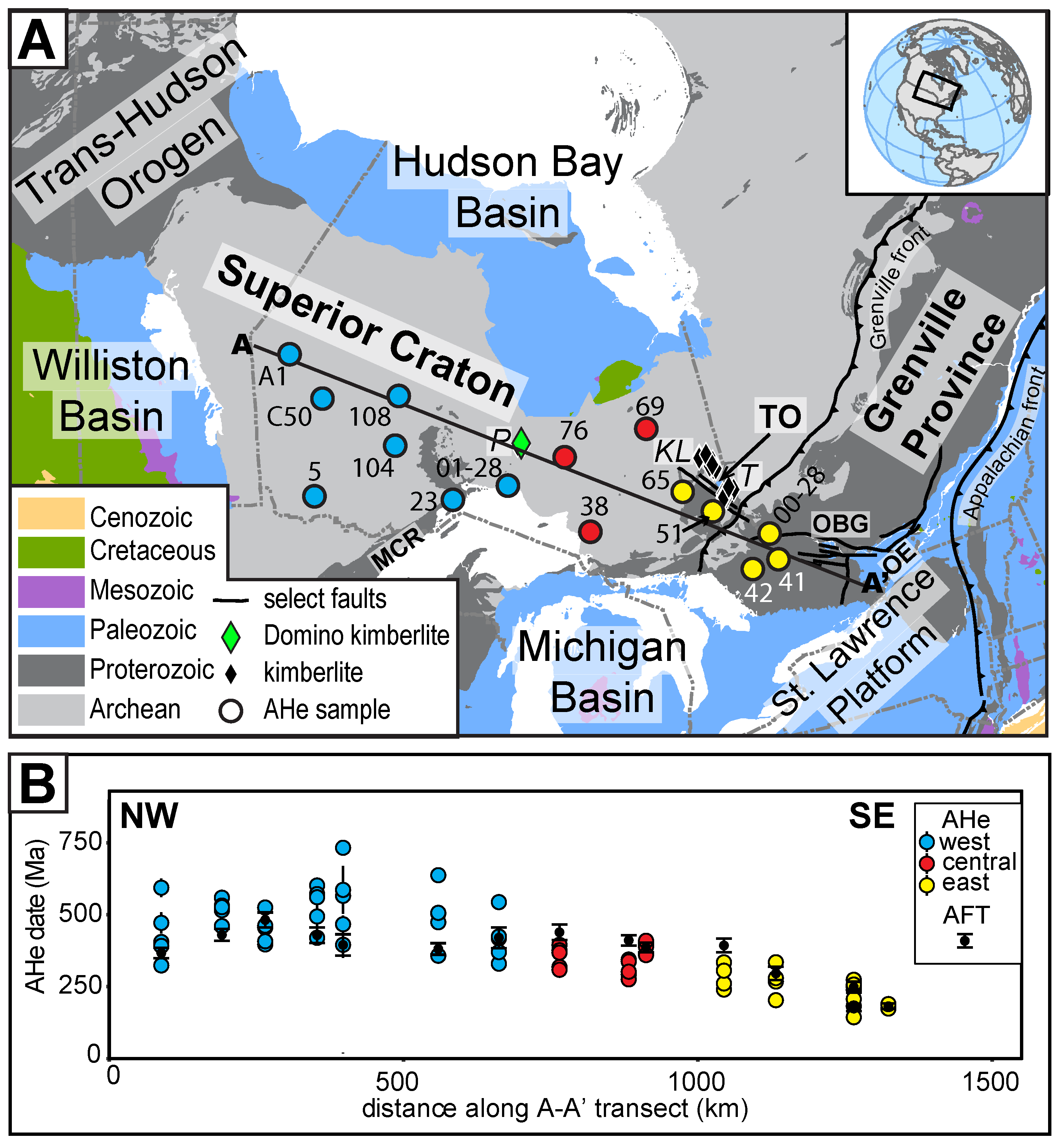
2.1. Geologic Setting

Our study region includes portions of the Archean Superior Craton and Mesoproterozoic Grenville Province. The Superior Craton is composed of several protocontinental blocks ranging from 3800 to 2800 Ma in age and was assembled from 2720 to 2680 Ma in a series of orogenic events (Figure 1A; e.g., [23,24]). The Grenville orogeny reworked the eastern Superior Craton from ~1090 to 980 Ma, with its now-eroded core forming the Mesoproterozoic Grenville Province (Figure 1A). In the Mesoproterozoic, the Midcontinent Rift affected the southern edge of the Superior Craton (Figure 1A; [25]). Subsequent Neoproterozoic rifting resulted in the intrusion of 590 Ma Grenville dikes and formation of several WNW-trending grabens, such as the Ottawa–Bonnechere graben in the Grenville Province (Figure 1A; [26,27]). Multiple phases of the Appalachian orogeny later impacted the eastern margin of the continent [28].
Kimberlites emplaced across the southern Canadian Shield include the ~220 Ma Pagwachuan field [29], located in the central part of our sample transect, as well as the 165–146 Ma Kirkland Lake and 155–126 Ma Timiskaming clusters [30,31], which are located closer to our transect’s eastern end (Figure 1A). The Kirkland Lake and Timiskaming fields form part of a broader corridor of kimberlites across the Canadian Shield characterized by a southeast-younging trend that coincides with the proposed track of the Great Meteor mantle plume [30]. Although the host rock of the Kirkland Lake and Timiskaming kimberlites at their currently exposed level is Precambrian basement, the pipes contain Ordovician to Middle Devonian marine sedimentary xenoliths [30,32,33]. This sedimentary xenolith suite, combined with the currently exposed kimberlite facies, implies up to 700 m of net denudation of the kimberlite pipes below the Jurassic to Cretaceous paleosurface. These relationships indicate that the craton was at sea level during Ordovician and Middle Devonian time and that up to 700 m of these units still buried the region at the time of kimberlite eruption [32,34]; note that this does not preclude the possibility that these kimberlites were buried post-emplacement by additional sedimentary rocks that were denuded before the present.
The kimberlite xenolith suites, along with sedimentary units preserved within down-dropped fault blocks such as the Timiskaming outlier, provide direct constraints on the Phanerozoic history of sedimentation and erosion in our study region. However, the Phanerozoic sequences preserved within the surrounding depositional areas—the Hudson Bay Basin to the north, the Williston Basin to the west, the Michigan Basin to the south, and the St. Lawrence Hudson Platform to the southeast (Figure 1A)—put these limited constraints into the broader depositional context. The sedimentary record within these basins and across the North American craton can be simplified into two main intervals of maximum burial across the craton separated by intervals of more substantial erosion, further subdivided into the six transgressive–regressive “Sloss” sequences [2].
For the first main burial phase, deposition began in the early to middle Cambrian to the west (modern coordinates) and in the Early Ordovician farther east (i.e., the Sauk sequence; [35,36]). Nonconformable deposition of these sequences on the Precambrian basement indicates that the craton was at the surface by these times in these places. The Middle Ordovician to Devonian included perhaps the widest transgression of the Phanerozoic (i.e., the Tippecanoe sequence). Stratigraphic and faunal similarities between the Hudson Bay Basin, Timiskaming outlier, St. Lawrence Platform, and Williston Basin suggest inundation of much of the Canadian Shield, including our study region, during this interval [35,37,38]. The onset of this transgression is roughly coeval with the beginning of the Taconic phase of the Appalachian orogeny and the shift from passive margin subsidence to convergence at the eastern Laurentian margin [35], while subsequent regression may be related to the onset of the Acadian phase of the Appalachian orogeny [35,39]. During the Early Devonian to Mississippian, another epeiric seaway likely connected the Hudson Bay and St. Lawrence Platform and extended over the current area of the Timiskaming outlier (i.e., Kaskaskia sequence) [33,35]. During the late Mississippian through Pennsylvanian (i.e., Absaroka sequence), the onset of the Alleghenian phase of the Appalachian orogeny occurred, and deposition was largely absent from basins north and east of the craton.
Interregional unconformities and hiatuses imply a subsequent, significant erosive episode, particularly in the western and central craton, from Pennsylvanian to Triassic time [35], which separates the first and second main burial phases. A final period of deposition occurred during Early Jurassic and later (i.e., Zuni and Tejas sequences). These units occurred primarily in the Williston Basin and may have blanketed part of the western Superior Craton, but their distribution was likely limited in the central and eastern craton [2,40].

2.2. Previous Thermochronology of the Superior Craton and Grenville Province

A variety of 40Ar/39Ar data constrains the mid-temperature thermal history across the southern Superior Craton and adjacent Grenville Province. 40Ar/39Ar closure temperatures are ~500 °C for hornblende and ~400−300 °C for biotite and muscovite [41,42,43]. Across the southern Superior Craton, hornblende and mica 40Ar/39Ar dates are commonly a few 100 Myr younger than zircon U-Pb results that date rock crystallization (generally ~2600 to 2400 Ma, e.g., [44]). These data indicate that reheating above ~350 °C did not occur after Archean to Mesoproterozoic time. Additionally, pseudotachylite 40Ar/39Ar dates from the 1850 Ma Sudbury impact structure and multi-diffusion domain modeling of K-feldspar 40Ar/39Ar data from Archean and Paleoproterozoic basement suggest that the Superior Craton cooled below 200−150 °C after ~1000 Ma [45,46]. In the southwestern Grenville Province, biotite 40Ar/39Ar dates are commonly ~1000−870 Ma, indicating that Phanerozoic heating above ~350 °C did not occur here after this time [47,48].
Previous low-temperature thermochronology data for basement rocks from the larger region include zircon (U-Th)/He (ZHe, sensitive to ~200 to <50 °C [49]), AFT (sensitive to ~110−60 °C, [50]), and AHe (sensitive to ~90−30 °C, e.g., [18]) results. These data generally indicate cooling during the late Neoproterozoic, heating and cooling during the Paleozoic, and possibly a second heating and cooling phase from the Late Cretaceous-Eocene to the present. These heating and cooling intervals have been interpreted as recording the burial and erosion of the Canadian Shield. To the west, in the Trans-Hudson Orogen and westernmost Superior Craton, AHe data record >3 km of unroofing between 650 and 440 Ma, with moderate reheating during Phanerozoic burial [21]. In the Williston Basin to the west, AFT data also suggest late Paleozoic heating and burial [51]. In the western Superior Craton, AFT data from exposed basement samples and from a 1.15 km–deep core hole indicate late Neoproterozoic unroofing of the craton, several kilometers of Paleozoic burial and erosion, and a possibly a lower magnitude phase of burial and erosion during the Late Cretaceous to early Tertiary [10,11,14,52]. In the southern craton, basement AFT data near the Michigan Basin suggest 2−5 km of late Paleozoic burial [12]. Core hole AFT data from the eastern Superior Craton suggest Ordovician to Carboniferous burial [53]. ZHe and AHe data from the eastern Superior Craton and western Grenville Province, combined with other geologic data, support >5 km of exhumation between ca. 590 and 470 Ma, with later reheating during Phanerozoic burial [22]. ZHe and AHe data from rift flanks of the Ottawa embayment in the Grenville Province also record late Paleozoic and Mesozoic burial [54]. Previous AFT data from the study region, including for the same samples analyzed for AHe in this study, were interpreted to record a Paleozoic heating–cooling event, likely related to burial under sedimentary cover that was thicker across the Grenville Province under foreland sediments shed from the Appalachian orogenic belt [13]. In summary, these results collectively record a first-order history consistent with exhumation during the late Neoproterozoic, burial and erosion during the Paleozoic, and potentially a lower magnitude episode of burial and erosion between Cretaceous time and the present that re-exhumed basement across the region to the surface.

3. Materials and Methods

3.1. (U-Th)/He Background and Samples

AHe thermochronology is used to constrain the thermal history of rocks by exploiting the radiogenic production and accumulation of 4He in U-Th-Sm-bearing minerals and the diffusive loss of that He at higher temperatures. This thermochronometer is sensitive to temperatures of ~30 to 90 °C, depending on radiation damage and grain size. Greater radiation damage increases the He retentivity of apatite (e.g., [55]). Apatite accumulates radiation damage proportional to its effective uranium concentration (eU) and the time spent below the damage annealing temperature. This damage can later be annealed at higher temperatures, thereby reducing the apatite He retentivity [56]. For samples that experienced slow cooling or partial He loss during heating, the radiation-damage effect can appear as a positive correlation between date and eU. In contrast, samples that return the same AHe date regardless of eU may have cooled more rapidly through the temperature sensitivity range of all the dated apatites and/or undergone complete He loss during heating [57]. Grain size also affects apatite He retentivity and can cause positive date–size correlations in samples that underwent a protracted thermal history [58], although kinetic effects from radiation damage may have greater leverage on the dates and obscure grain size patterns. (U-Th)/He datasets can be simulated using kinetic models that account for the influence of both radiation damage and grain size on (U-Th)/He data [57,59]. In general, protracted thermal histories, like those associated with deep-time cratonic datasets, amplify dispersion because of kinetics and other effects, while dispersion is minimized for younger samples with rapid cooling histories (summary in [60]).
We targeted basement samples of 15 Archean and Mesoproterozoic gneisses, tonalites, granodiorites, and granites along an ~1400 km NW–SE transect across the southern Canadian Shield (Figure 1A; Table S1, Supplementary Materials). Apatite crystals were previously separated from these rock samples as part of an apatite fission-track (AFT) study, for which results were reported in [61] and spatially visualized in [13]. Samples with the highest quality apatite crystals (abundant, inclusion-free, whole crystals) from this AFT investigation were selected for AHe analysis. We acquired no new AFT data in this study, but for completeness, we include unpublished details of the existing AFT data in Tables S2–S4.
We additionally obtained a sample of the Triassic Domino kimberlite from the Pagwachuan kimberlite cluster from De Beers Canada. This sample is located in the middle of the transect, and its eruption was dated at 220 ± 7.8 Ma through perovskite U-Pb analysis [29]. The substantially younger age of the Triassic Domino kimberlite relative to the host Precambrian basement means that its (U-Th)/He data can isolate the craton’s post-Triassic thermal history. Apatite grains were separated from this sample using standard crushing, grinding, water density, magnetic, and heavy liquid lithium metatungstate methods at the University of Colorado Boulder (CU).

3.2. (U-Th)/He Analytical Methods
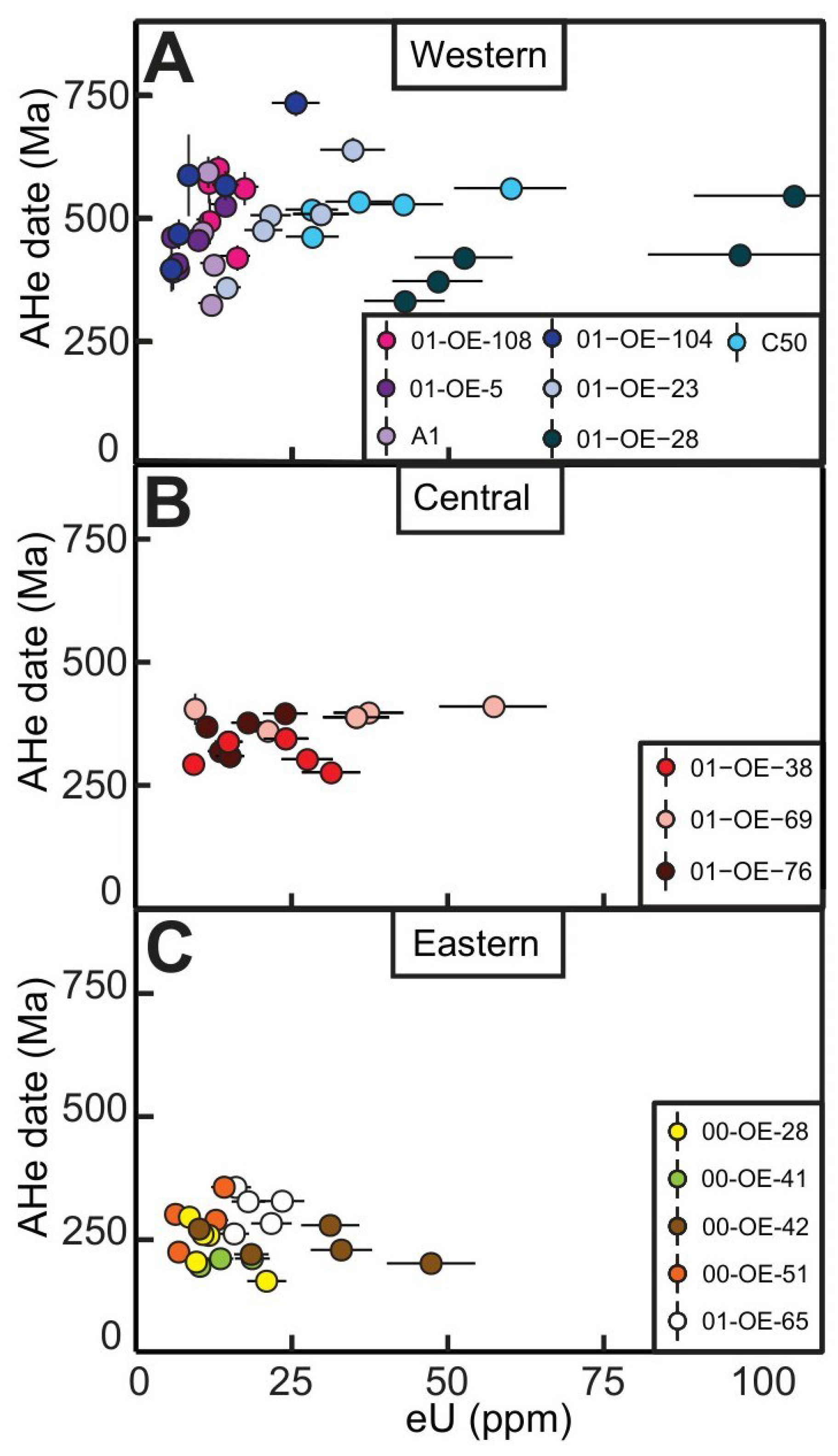
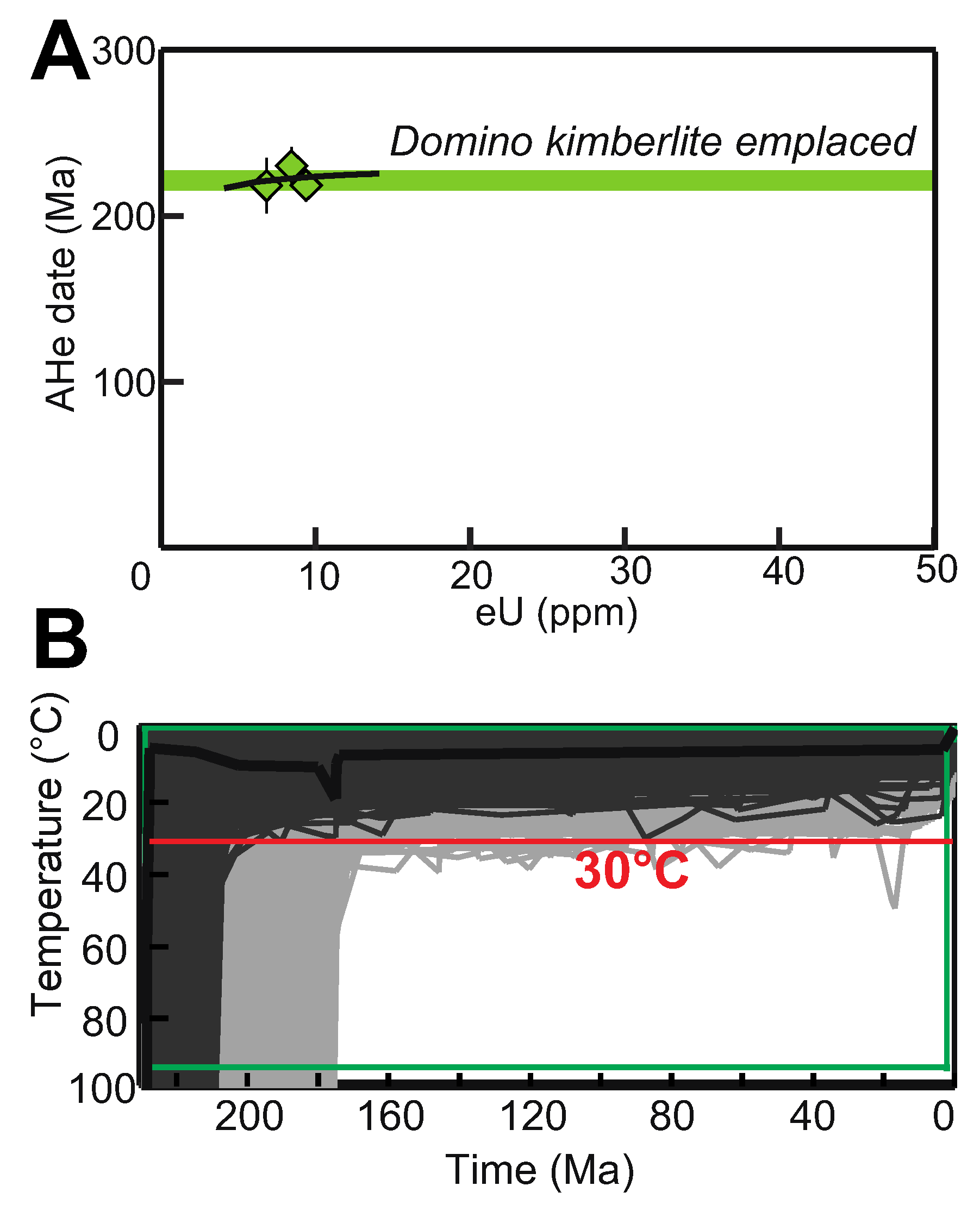
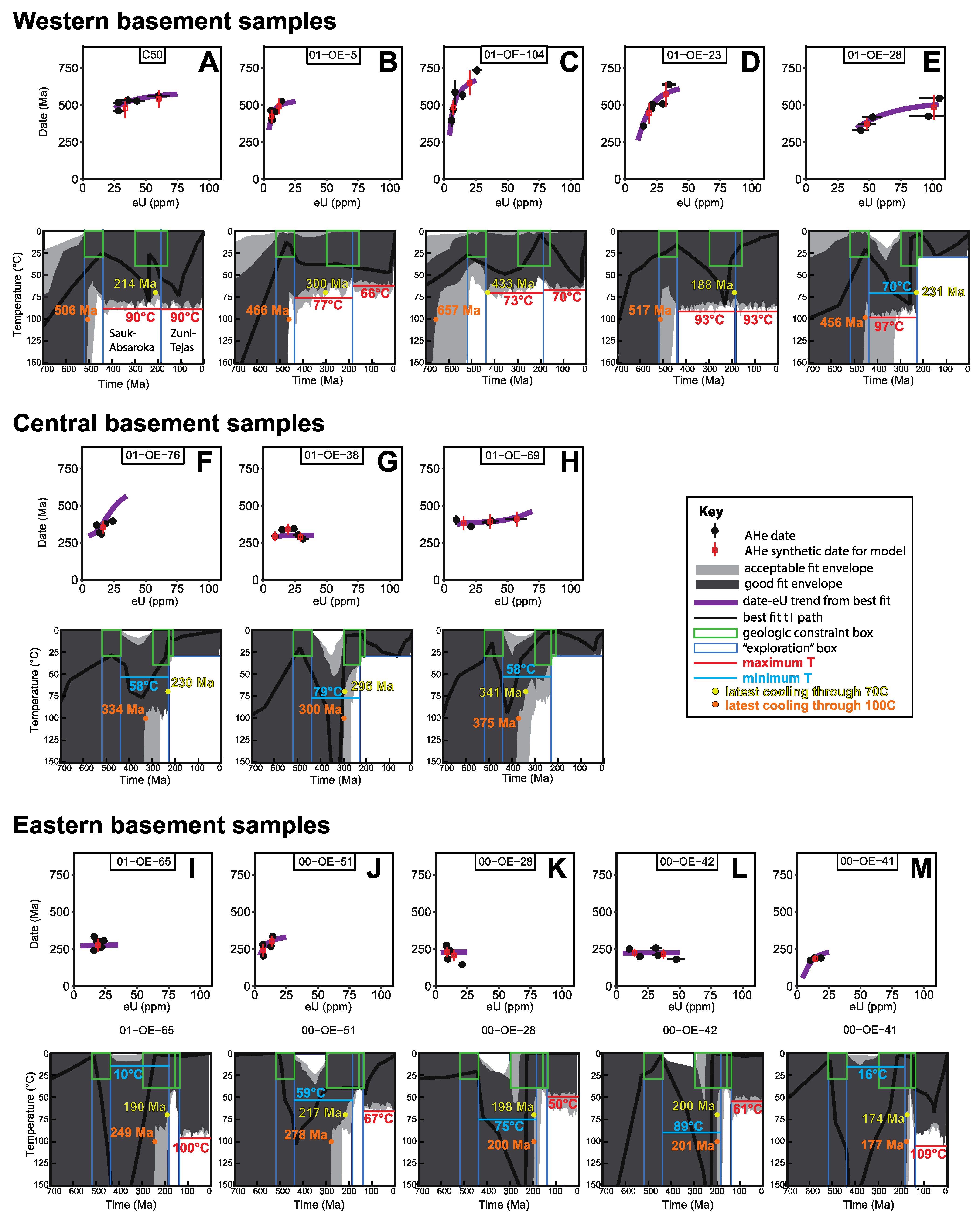
All AHe data were acquired in the Thermochronology Research and Instrumentation Lab (TRaIL) at CU. Euhedral, clear, and inclusion-free grains were selected, photographed, and dimensionally measured using a Leica M165 binocular microscope with transmitted, polarized light and a calibrated digital camera. Single grains were then packed into Nb tubes for analysis. He measurements were taken on an ASI Alphachron extraction and measurement line. Nb packets were lased under vacuum at 6A for 5 min to extract radiogenic 4He and then lased a second time to ensure complete mineral degassing. The resultant gas was spiked with 3He and measured in a quadrupole mass spectrometer. Each aliquot was spiked with a 235U, 230Th, and 145Nd tracer and dissolved in HNO3 for 2 h at 80 °C. U, Th, and Sm measurements were taken on a Thermo-Finnigan Element2 sector field ICPMS or an Agilent 7900 quadrupole ICPMS at CU. Uncertainties on individual grain dates are reported and plotted at 2σ and include the propagated analytical uncertainties for U, Th, Sm, and He. Uncertainties on eU are estimated, reported, and plotted at 15% of the eU value based on the estimates of [62]. All grains with <5 ppm eU were discarded as at risk for He implantation because low-eU crystals are most susceptible to bias from this effect [63].

4. Results

We obtained a total of 75 AHe analyses from the sample suite. All data are reported in Table S1 following the (U-Th)/He reporting recommendations of [64]. Figure 1B shows the individual AHe dates for each sample plotted onto a NW–SE transect line across the study area (transect location in Figure 1A). AHe date–eU plots for basement samples grouped by western, central, and eastern sample suites are in Figure 2, with the Domino kimberlite AHe date–eU plot in Figure 3A. AHe date-equivalent spherical radius plots for basement samples are in Figure S1, but they lack clear correlations and, therefore, are not discussed further below. For the basement samples, we do not report mean sample dates because this summary statistic is only appropriate for samples expected to have normally distributed date populations [60], which is not true for many of the samples in our dataset, such as those with date–eU correlations. For the kimberlite sample, we do report a mean sample date and the associated sample standard error because its reproducible dates suggest that this summary statistic is appropriate [60].
The basement AHe dates are oldest in the western ~500 km of the sample transect and generally decrease eastward (Figure 1B). The seven western samples exhibit the greatest variability in individual AHe dates, ranging from 733 ± 26 to 330 ± 6 Ma (Figure 1B and Figure 2A). These samples show substantial intra-sample date scatter (four samples with >18% dispersion) and include samples (N = 4) with AHe date–eU correlations. The three samples in the central part of the transect yield individual AHe dates of 410 ± 13 to 292 ± 13 Ma that are generally younger and more reproducible (5–11% dispersion) than those of the western suite (Figure 1B and Figure 2B). The five eastern samples, in general, are still younger than those in the western and central suites, with single-grain dates from 335 ± 18 to 144 ± 9 Ma (Figure 1B and Figure 2C). When compared with the existing AFT data for these same samples, AHe dates from western samples are older than the AFT results, while central and eastern samples have AHe dates that overlap with or are younger than the AFT dates.
The Domino kimberlite sample, located in the middle of our transect, yielded three AHe dates with a mean and 1σ standard error of 222 Ma ± 4 Ma (Figure 2D). This result overlaps with the pipe’s emplacement age of 220 ± 7.8 Ma [29].

5. Discussion

5.1. Geologic Context, Data Patterns, and Model Framework

The regional geologic context (Section 2.1) indicates that the dominant control on the regional Phanerozoic thermal history of the southern Canadian Shield was likely the deposition and erosion of Paleozoic and Mesozoic strata like those preserved in surrounding intracratonic basins and as outliers in down-dropped blocks on the craton. Phanerozoic volcanic and metamorphic activity was limited, making such processes unlikely to explain the first-order data patterns. We, therefore, interpret our results in the context of the two broad burial phases: one in the Paleozoic to early Mesozoic and one in the late Mesozoic to Cenozoic, separated by an erosional interval.
Several first-order conclusions can be drawn from the qualitative data patterns when interpreted within this burial and erosion context. First, AHe dates older than the ~520 to 440 Ma onset of burial in basins adjacent to the study region are found only in the western samples, implying that Phanerozoic heating/burial was insufficient to completely reset the AHe dates (Figure 1B). In contrast, all AHe dates from the central and eastern samples are younger than 440 Ma, suggesting hotter Phanerozoic temperatures and greater Phanerozoic burial eastward. Second, our dataset contains few basement AHe dates as young as the late Mesozoic–Cenozoic burial phase, indicating that heating/burial in this interval either did not occur or was not hot enough to fully reset the AHe dates (Figure 1B and Figure 2). These results are consistent with a history of Paleozoic–early Mesozoic burial by strata that were thicker to the east, followed by possible burial by late Mesozoic and younger units of lesser thickness. This interpretation assumes that the entire study region underwent a similar interval of pre-Paleozoic residence at low temperatures, which appears reasonable given previous inference of multi-kilometer exhumation in late Neoproterozoic to early Paleozoic time [10,11,14,21,22] to develop the Great Unconformity erosion surface across the southern and central Canadian Shield [21,22].
The pattern of high intrasample AHe-date dispersion in western samples is also compatible with a history characterized by greater Phanerozoic heating and burial eastward. This date dispersion is amplified for samples that underwent protracted thermal histories, partial resetting, and partial radiation-damage annealing during reheating and burial such that differences in He-diffusion kinetics caused by variable radiation damage, grain size, zonation, and other factors are magnified and can be expressed as a broad array of dates [60]. In contrast, samples that were heated enough to anneal radiation damage and thus reduce differences in He retentivity among the apatite grains or that rapidly cooled through the AHe temperature sensitivity range (~90–30 °C) yield more reproducible dates. Thus, the greater AHe date dispersion of western samples relative to those in the central part of the transect can be explained by a regional thermal history characterized by an early protracted history during which the apatite grains accumulated radiation damage, followed by a heating event that was cooler in the west, causing only partial damage annealing and He loss, and hotter to the east, where it induced complete damage annealing and He loss.
The differences in AHe and AFT dates across the region are further compatible with greater heating and damage annealing eastward. Western samples include those with AHe dates older than AFT dates, while central and eastern samples have AHe dates universally younger than or overlapping with the AFT dates (Figure 1B). Patterns of AHe dates older than AFT dates (also called “inverted” dates) are predicted by radiation damage accumulation and annealing models for He diffusion and have been observed previously in Precambrian basement datasets. Such inverted dates can be explained by the accumulation of sufficient radiation damage, such that the AHe system becomes sensitive to higher temperatures than the AFT system and thus records older dates for the same thermal history [65]. Consequently, in our dataset, the inverted dates in some western samples is explicable by partial resetting and partial annealing during Phanerozoic burial, while the more typical relationships of AHe overlapping with or younger than AFT to the east are consistent with full resetting and annealing during burial.
In summary, the regional geologic context implies a Phanerozoic thermal history characterized by reheating during one or more burial episodes. The coherent pattern of younger AHe dates, generally less intrasample AHe date dispersion, and more typical AHe–AFT date relationships eastward is qualitatively consistent with a Phanerozoic heating/burial magnitude that was greater in the east. Greater Phanerozoic heating/burial eastward was also inferred previously from the AFT dataset for these samples [13]. Next, we quantitatively test this interpretation using inverse thermal history modeling.

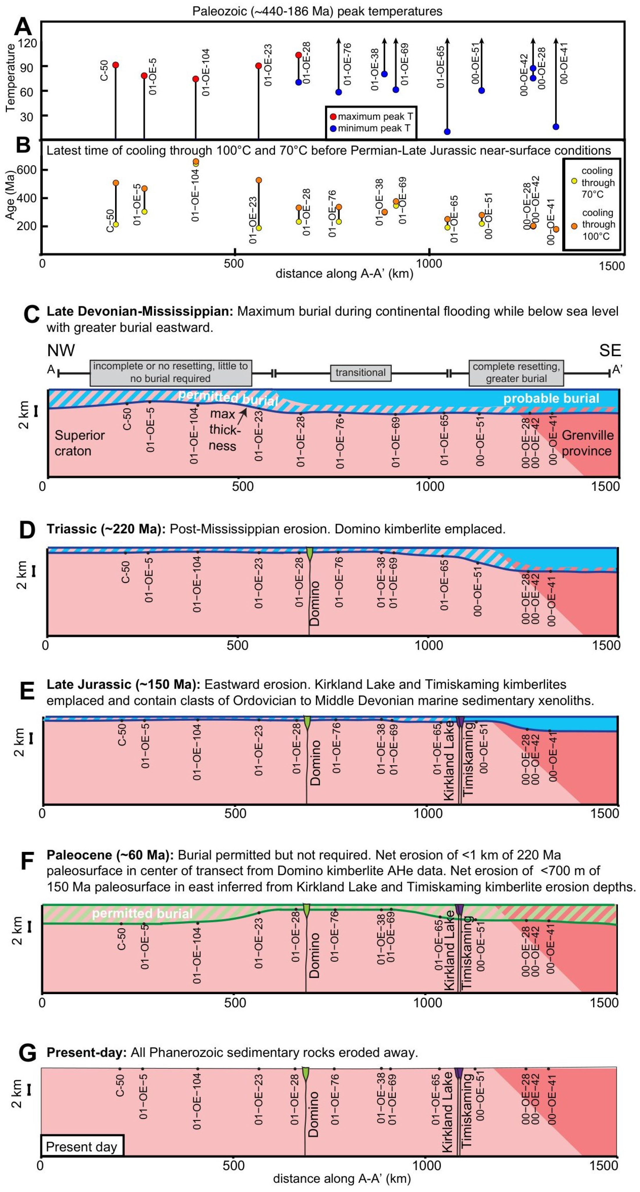
5.2. Testing Phanerozoic Burial and Erosion across the Southern Canadian Shield

Several approaches and software programs are available for inverse thermal history modeling to decipher the time–temperature (tT) paths that can explain both the thermochronology and geologic data in a thermochronology study. The choice of strategy is affected by the probable complexity of the tT path and the geologic context [60,66,67,68,69]. We chose to use HeFTy [70] because geologic and geochronologic data can be easily incorporated into inverse thermal history simulations, making it effective for the hypothesis testing approach we employed [60]. HeFTy also does not automatically favor simple cooling-only tT paths, which may be an inappropriate bias for deep-time studies in cratonic regions that are commonly characterized by multiple phases of heating/burial and cooling/erosion over hundreds of millions of years. HeFTy uses a Monte-Carlo approach to generate random time–temperature (tT) paths that pass through a set of user-defined tT constraints based on supporting geological data, calculates the goodness of fit of the dates predicted by each tT path relative to the input data, and displays all “good” and “acceptable” paths [70].
We adopted a model framework that tested whether two Phanerozoic heating and cooling episodes, as would be caused by burial and erosion during the two main Phanerozoic cratonic transgressive and regressive phases, could coherently explain the thermochronology data patterns across the southern Canadian Shield. We tested this hypothesis by beginning each sample simulation with tT constraints based on local 40Ar/39Ar data, requiring cooling/erosion to near-surface conditions by the onset of sedimentation in adjacent basins at ~520−440 Ma, allowing subsequent reheating/burial and then cooling/erosion to another near-surface constraint based on the regional Mesozoic unconformity, then allowing a post-Triassic reheating/burial phase and ending at present-day surface conditions. We also modeled the AHe data from the Triassic Domino kimberlite to determine the maximum allowable post-emplacement reheating in the central part of the transect, beginning at 900−1000 °C at the 220 ± 7.8 Ma age of pipe emplacement and allowing post-eruption heating of up to 100 °C (Figure 3B). Based on this kimberlite model result (see Section 5.3), we restricted heating to <30 °C after 220 Ma in the central basement sample models. For eastern samples, we imposed a constraint requiring tT paths to cool to upper crustal temperatures (<40 °C, assuming a maximum depth of ~1.75 km, surface temperature of 5 °C, and cratonic geothermal gradient of 20 °C/km) by 165−125 Ma when the Kirkland Lake and Timiskaming kimberlites erupted. We adopted this constraint because observations suggest no more than 700 m of pipe erosion since kimberlite emplacement [32,34]. The 1.75 km depth was to allow for lateral variations and not overly constrain the model. However, these eastern sample models permit post-emplacement heating and burial because observations do not preclude subsequent burial of the kimberlite.
We carried out three sets of simulations for the basement samples: one for the AHe data (Figure 4); one for the AFT dates and track lengths (the AFT models; Figure S3); and one combining the AHe dates, AFT dates, and track lengths (the AHe + AFT models; Figure S4). We focus primarily on the results of the AHe simulations in our discussion because the Domino kimberlite is important for constraining the post-emplacement cooling history; for this sample, we have only AHe data, and the track-length data are limited by the lack of angle-to-c-axis information and the absence of compositional data. However, all sets of simulations yield similar broad patterns with secondary differences in their temperature and timing outcomes that do not change the conclusions drawn below about the regional burial and erosion history.
Thermal history modeling demands a choice of how to input the thermochronology data. For AHe data input, we used a standard method in which synthetic grains are generated by averaging the date, eU, and equivalent spherical radii values for apatite grains within subgroups for each sample [60,68]. The aim of this approach was to bin apatite grains into kinetic populations of similar He retentivity while also capturing the observed dispersion within each eU subgroup that exceeds the analytical uncertainty on the individual dates. We imposed an uncertainty on each synthetic grain that is the larger of the standard deviation of dates within the bin or 12% of their mean. Two western samples that exhibit substantial AHe data dispersion not correlated with eU were excluded from the modeling (A1, 01-OE-108). We used the radiation damage accumulation and annealing model (RDAAM) for helium diffusion in apatite [18] and the annealing model of [71] for AFT annealing. Full details of modeling are in Table S5 and Figure S2.

5.3. Thermal History Modeling Results

The AHe data from the Triassic Domino kimberlite were simulated to constrain the maximum post-eruption burial temperature. The result shows rapid post-emplacement cooling and limits reheating to <30 °C (Figure 3B). As noted above, we applied this reheating limit as a tT constraint in the thermal history simulations of basement samples in the center of our transect by limiting post–220 Ma heating to <30 °C.
All thermal history models of the AHe data yielded good-fit tT paths, indicating that a history compatible with the regional geologic context, characterized by one or two Phanerozoic heating/burial and cooling/erosion episodes, can explain the data (Figure 4). Figure 5A,B summarize several key constraints from each model along the NW–SW transect. For the Paleozoic–early Mesozoic burial time frame, the westernmost samples suggest maximum peak temperatures of 73–97 °C, and most do not require any heating to explain the data (Figure 4A–D). In contrast, eastern samples appear to require heating, with minimum peak temperatures of 10–89 °C (Figure 4I–M). The latest permitted time of cooling through temperatures of 100 °C and 70 °C before near-surface temperatures in Permian–Late Jurassic time is older to the west and younger for samples in the eastern 400 km of the transect, suggesting later erosion to the east (Figure 5B). Post–186 Ma heating and burial are permitted by some samples but not required by any of the data.

5.4. Phanerozoic Burial and Erosion Model for the Southern Canadian Shield

We constructed a series of cross-sections along our transect across the southern Canadian Shield for five different snapshots in time that summarize our preferred interpretations (Figure 5C–G). Although these reconstructions were limited by our relatively coarse sample density, this model is intended to represent the first-order Phanerozoic history across the region, exploit the available geologic information, honor the thermal history modeling results, and be consistent with previous interpretation of the AFT data [13]. To convert temperatures derived from the thermal history models into burial depth estimates (Figure 5A, right axis on plot), we assume a 5 °C surface temperature based on the current approximate mean annual temperature of the region and a typical cratonic geotherm of 20 °C/km based on a modern mean heat flow value of ~43 mW/m2 for the southern Superior Craton [72,73]. We refer to absolute sedimentary thicknesses below primarily to facilitate a sense of relative burial magnitudes across the craton and to emphasize the overall spatial patterns, but we avoid overinterpreting specific burial and erosion values because of uncertainty in how the surface temperatures and heat flow changed through time. Although isolated areas of higher (>50 mW/m2) and lower (<30 mW/m2) heat flow occur in the study region, the systematic northwest-to-southeast younging pattern of our thermochronology data do not align with this heat flow heterogeneity, suggesting other controls on the first-order thermochronology data patterns. No abrupt difference in burial and erosion history is required by our dataset across the Grenville Front, so our reconstructions show no dramatic change at this boundary. This interpretation appears reasonable given that lithospheric thicknesses and heat flow are roughly similar across this boundary, and the southwestern Grenville Province is thought to be underlain by Archean crust similar to the Superior Craton [74].
Our reconstructions feature eastward-thickening Paleozoic burial and limited or no Cretaceous and younger re-burial. In the west, no Paleozoic burial is required by the thermal history modeling results, although multi-kilometer burial is allowed. In the east, >3 km of burial is favored based on the thermal history simulation results for most samples (Figure 5A,C). Here, Ordovician to Devonian marine sedimentary xenoliths in the Jurassic Kirkland Lake and Timiskaming kimberlites document this burial event and show that the shield was inundated and below sea level in early Paleozoic time [32,33]. Although our thermal history models are insensitive to the precise timing of maximum burial, Late Devonian to Mississippian is likely because units in this age range occur in the Timiskaming outlier, and an epeiric seaway connecting the Hudson Bay and St. Lawrence Platform has been inferred in this interval [33,35]. Exhumation likely occurred during the Pennsylvanian to Triassic erosional episode, as suggested by interregional unconformities and stratigraphic data [35]. The Domino kimberlite was emplaced at 220 Ma, and the overlap in kimberlite AHe date and emplacement age implies that the central craton was buried by ≤1 km of Paleozoic overburden (Figure 5D) in the Late Triassic. In contrast, the thermochronology data are consistent with post-Triassic cooling and exhumation of the sedimentary package farther east (Figure 5D). By the Late Jurassic (~150 Ma; Figure 5E), the eastern sedimentary cover was likely reduced to ≤700 m based on the inferred erosion depths of the Kirkland Lake kimberlites that were emplaced then [32,34]. During Paleocene time (~60 Ma; Figure 5F), burial by sedimentary rocks is permitted but not required by the data.
A combination of mantle dynamic and tectonic effects can explain the burial and erosion patterns across our transect. Dynamic subsidence associated with Pangea assembly, as well as far-field tectonic effects from Appalachian orogenesis, may have caused subsidence during the Paleozoic [8,15]. The eastward-thickening burial pattern is attributable to sedimentary detritus shed from the Appalachian orogenic belt, consistent with suggestions from previous AFT studies in the region [10,11,12,13,53,75]. Subsequent uplift and erosion may be due to the cessation of subduction along the eastern Laurentian margin and associated mantle warming that caused the uplift of cratonic North America from ~330 to 250 Ma [7,8]. Passive margin rejuvenation, plate reorganization, and increased heat flow and exhumation from the Great Meteor hotspot or other asthenospheric upwelling during the Late Jurassic to Cretaceous have been invoked to explain Late Jurassic to Cretaceous cooling to the southeast of our study area in the Adirondacks and Appalachians [76,77,78,79] and may also have variably affected our easternmost study area. No burial is required after 186 Ma across the region, but if deposition did occur, it likely affected the western part of our transect because of distal dynamic subsidence from Farallon slab subduction [3]. The outcomes of this work can be used to better test and calibrate mantle dynamic models that provide a potential explanation for low-amplitude, long-wavelength burial, erosion, and elevation change in the interior of the southern Canadian Shield distal from the plate boundaries.

6. Conclusions

Phanerozoic AHe dates across an approximately 1400 km–long region of the southern Canadian Shield, together with geologic information and existing AFT data, constrain a spatially variable regional thermal history that we interpret in the context of cratonic burial and erosion. AHe dates for basement samples are older in the west than the east. In the center of the transect, AHe dates from the Domino kimberlite suggest little or no heating after shallow emplacement, indicating ≤1 km of burial and exhumation since ~220 Ma. Using thermal history modeling of these data, we find that two Phanerozoic heating/burial and cooling/erosion episodes across the southern Canadian Shield, caused by continental inundation during the two main Phanerozoic transgressive and regressive phases, can coherently explain the regional thermochronology data patterns. Our preferred burial and erosion model was constructed from geologic information, quantitative thermal history constraints derived from inverse modeling of thermochronology data, and simple geothermal gradient assumptions. Our results provide limits on the maximum allowed or minimum required heating from 440 to 186 Ma. In the western craton, Phanerozoic burial is not necessarily required, but farther east, >3 km of burial appears needed to explain the data. Sedimentary xenoliths in kimberlites indicate that the craton was at sea level in the early Paleozoic. The timing and eastward-thickening nature of this first burial phase suggest that subduction at the Appalachian margin and perhaps other geodynamic effects associated with Pangea assembly may have caused subsidence of the shield. Erosion in the easternmost part of the transect likely occurred later than farther west, which may have resulted from uplift because of the cessation of subduction along the Appalachian margin. In the central part of our transect, AHe dates for the Domino kimberlite limit post–220 Ma burial to ≤1 km, and in the east, kimberlite-hosted sedimentary xenoliths and inferred pipe erosion levels suggest that ≤700 m of Paleozoic strata remained on the craton by Jurassic time. This burial and erosion model can be refined in the future with higher-density thermochronology datasets that can better constrain more detailed variation in thermal histories across the region that may reflect the influence of the Great Meteor hotspot, faulting, or other effects.

Supplementary Materials

The following supporting information can be downloaded at https://www.mdpi.com/article/10.3390/min14010057/s1, Table S1: Apatite (U-Th)/He data; Table S2: Apatite fission-track data from basement rock samples; Table S3: Apatite fission-track date modeling input; Table S4: Apatite fission-track lengths; Table S5: (a) Part 1: Thermal history model input table; (b) Part 2: Thermal history model input table. Figure S1: Apatite (U-Th)/He date vs. grain radius plots for basement samples; Figure S2: Model structure based on geologic context used in thermal history models for full model durations. The tT constraint boxes are placed to limit the tT space explored based on independent geologic information, while exploration boxes are placed to ensure that the full tT space within the box is explored (i.e., to enable cooling and heating paths to be tested that otherwise would not be). (A) Model structure for the Domino kimberlite. (B) Simplified geologic map of the southern Canadian Shield showing basement samples subdivided into groups with slightly different tT constraints was applied based on the available geologic information: (C) no kimberlite constraint applied, (D) Domino kimberlite constraint applied, and (E) eastern kimberlite constraint applied. Models and samples marked with an asterisk indicate 1140–1100 Ma model start time because of location in Grenville Province or near Midcontinent Rift. Refer to the text for more details regarding the kimberlite constraints. See Table S5 for full description of the rationale for all geologic constraints used in the thermal history simulations. Numbers on constraint boxes correspond with those in Table S5. Figure S3: Track-length distributions (top plots) and thermal history modeling results (bottom plots) of AFT date and track-length data. Thermal history models are annotated as in Figure S3. Figure S4: Thermal history modeling results of combined apatite (U-Th)/He (AHe) data, apatite fission-track (AFT) dates, and track-length distributions. Thermal history models are annotated as in Figure S3. Models for samples that failed to find any fits to the data are not shown. Over long timescales, for thermal histories characterized by partial He loss and partial fission-track annealing, small inconsistencies in kinetic models for He diffusion and track-length annealing are amplified. This can make it challenging to fit both AHe and AFT data simultaneously, as manifested by the greater difficulty of finding fits for the western and central basement samples. Figure S5: Thermal history modeling results of apatite (U-Th)/He data from Precambrian basement samples, showing constraint points of each time–temperature path. Figure S6: Thermal history modeling results of apatite (U-Th)/He data from Precambrian basement samples, showing the full duration of each model.

Author Contributions

Conceptualization, R.M.F.; methodology, R.M.F. and J.R.M.; software, C.P.S.; validation, C.P.S.; formal analysis, J.R.M. and C.P.S.; investigation, J.R.M. and C.P.S.; resources, R.M.F.; data curation, C.P.S. and B.P.K.; writing—original draft preparation, C.P.S.; writing—review and editing, R.M.F. and C.P.S.; visualization, C.P.S.; supervision, R.M.F.; project administration, R.M.F. and C.P.S.; funding acquisition, R.M.F. All authors have read and agreed to the published version of the manuscript.

Funding

This research was funded by National Science Foundation (NSF) grant EAR-1450181 to RMF. NSF EAR-1126991 and -1559306 to RMF provided support for the instrumentation in the CU TRaIL used to acquire the (U-Th)/He data.

Data Availability Statement

All data used in the report may be found at https://doi.org/10.17605/OSF.IO/MN94V (accessed on 31 December 2023).

Acknowledgments

We thank Mike Hartley (De Beers) for access to the Domino kimberlite sample. We appreciate helpful comments from three anonymous reviewers that improved the clarity of the manuscript.

Conflicts of Interest

The authors declare no conflicts of interest.

References

  1. Sloss, L.L. Sequences in the Cratonic Interior of North America. Geol. Soc. Am. Bull. 1963, 74, 93–114. [Google Scholar] [CrossRef]
  2. Sloss, L.L. Tectonic Evolution of the Craton in Phanerozoic Time. In Sedimentary Cover: North American Craton; Sloss, L.L., Ed.; Geological Society of America: Boulder, CO, USA, 1988; Volume D-2, pp. 25–51. [Google Scholar]
  3. Mitrovica, J.X.; Beaumont, C.; Jarvis, G.T. Tilting of Continental Interiors by the Dynamical Effects of Subduction. Tectonics 1989, 8, 1079–1094. [Google Scholar] [CrossRef]
  4. Gurnis, M. Phanerozoic Marine Inundation of Continents Driven by Dynamic Topography above Subducting Slabs. Nature 1993, 364, 589–593. [Google Scholar] [CrossRef]
  5. Burgess, P.M.; Gurnis, M.; Moresi, L. Formation of Sequences in the Cratonic Interior of North America by Interaction between Mantle, Eustatic, and Stratigraphic Processes. Geol. Soc. Am. Bull. 1997, 109, 1515–1535. [Google Scholar] [CrossRef]
  6. Liu, L.; Spasojevic, S.; Gurnis, M. Reconstructing Farallon Plate Subduction Beneath North America Back to the Late Cretaceous. Science 2008, 322, 934–938. [Google Scholar] [CrossRef] [PubMed]
  7. Flowers, R.M.; Ault, A.K.; Kelley, S.A.; Zhang, N.; Zhong, S. Epeirogeny or Eustasy? Paleozoic–Mesozoic Vertical Motion of the North American Continental Interior from Thermochronometry and Implications for Mantle Dynamics. Earth Planet. Sci. Lett. 2012, 317–318, 436–445. [Google Scholar] [CrossRef]
  8. Zhang, N.; Zhong, S.; Flowers, R.M. Predicting and Testing Continental Vertical Motion Histories since the Paleozoic. Earth Planet. Sci. Lett. 2012, 317–318, 426–435. [Google Scholar] [CrossRef]
  9. Tasistro-Hart, A.R.; Macdonald, F.A. Phanerozoic Flooding of North America and the Great Unconformity. Proc. Natl. Acad. Sci. USA 2023, 120, e2309084120. [Google Scholar] [CrossRef]
  10. Crowley, K.D.; Ahern, J.L.; Naeser, C.W. Origin and Epeirogenic History of the Williston Basin: Evidence from Fission-Track Analysis of Apatite. Geology 1985, 13, 620–623. [Google Scholar] [CrossRef]
  11. Crowley, K.D.; Kuhlman, S.L. Apatite Thermochronometry of Western Canadian Shield: Implications for Origin of the Williston Basin. Geophys. Res. Lett. 1988, 15, 221–224. [Google Scholar] [CrossRef]
  12. Crowley, K.D. Thermal History of Michigan Basin and Southern Canadian Shield from Apatite Fission Track Analysis. J. Geophys. Res. 1991, 96, 697–711. [Google Scholar] [CrossRef]
  13. Kohn, B.P.; Gleadow, A.J.W.; Brown, R.W.; Gallagher, K.; Lorencak, M.; Noble, W.P. Visualizing Thermotectonic and Denudation Histories Using Apatite Fission Track Thermochronology. Rev. Mineral. Geochem. 2005, 58, 527–565. [Google Scholar] [CrossRef]
  14. Feinstein, S.; Kohn, B.; Osadetz, K.; Everitt, R.; O’Sullivan, P. Variable Phanerozoic Thermal History in the Southern Canadian Shield: Evidence from an Apatite Fission Track Profile at the Underground Research Laboratory (URL), Manitoba. Tectonophysics 2009, 475, 190–199. [Google Scholar] [CrossRef]
  15. Pinet, N. Far-Field Effects of Appalachian Orogenesis: A View from the Craton. Geology 2016, 44, 83–86. [Google Scholar] [CrossRef]
  16. Kohn, B.; Gleadow, A. Application of Low-Temperature Thermochronology to Craton Evolution. In Fission-Track Thermochronology and Its Application to Geology; Malusà, M.G., Fitzgerald, P.G., Eds.; Springer Textbooks in Earth Sciences, Geography and Environment; Springer International Publishing: Cham, Switzerland, 2019; pp. 373–393. ISBN 978-3-319-89419-5. [Google Scholar]
  17. Flowers, R.M.; Mahan, K.H.; Bowring, S.A.; Williams, M.L.; Pringle, M.S.; Hodges, K.V. Multistage Exhumation and Juxtaposition of Lower Continental Crust in the Western Canadian Shield: Linking High-Resolution U-Pb and 40Ar/39Ar Thermochronometry with Pressure-Temperature-Deformation Paths: Multistage Exhumation of Lower Crust. Tectonics 2006, 25, TC4003. [Google Scholar] [CrossRef]
  18. Flowers, R.M. Exploiting Radiation Damage Control on Apatite (U–Th)/He Dates in Cratonic Regions. Earth Planet. Sci. Lett. 2009, 277, 148–155. [Google Scholar] [CrossRef]
  19. Ault, A.K.; Flowers, R.M.; Bowring, S.A. Phanerozoic Burial and Unroofing History of the Western Slave Craton and Wopmay Orogen from Apatite (U–Th)/He Thermochronometry. Earth Planet. Sci. Lett. 2009, 284, 1–11. [Google Scholar] [CrossRef]
  20. Ault, A.K.; Flowers, R.M.; Bowring, S.A. Phanerozoic Surface History of the Slave Craton. Tectonics 2013, 32, 1066–1083. [Google Scholar] [CrossRef]
  21. Sturrock, C.P.; Flowers, R.M.; Macdonald, F.A. The Late Great Unconformity of the Central Canadian Shield. Geochem. Geophys. Geosystems 2021, 22, e2020GC009567. [Google Scholar] [CrossRef]
  22. Peak, B.A.; Flowers, R.M.; Macdonald, F.A. Ediacaran-Ordovician Tectonic and Geodynamic Drivers of Great Unconformity Exhumation on the Southern Canadian Shield. Earth Planet. Sci. Lett. 2023, 619, 118334. [Google Scholar] [CrossRef]
  23. Percival, J.A.; Skulski, T.; Sanborn-Barrie, M.; Stott, G.M.; Leclair, A.D.; Corkery, M.T.; Boily, M. Geology and Tectonic Evolution of the Superior Province, Canada. Tecton. Styles Can. Lithoprobe Perspect. Spec. Pap. 2012, 49, 321–378. [Google Scholar]
  24. Hynes, A.; Rivers, T. Protracted Continental Collision—Evidence from the Grenville Orogen. Can. J. Earth Sci. 2010, 47, 591–620. [Google Scholar] [CrossRef]
  25. Swanson-Hysell, N.L.; Hoaglund, S.A.; Crowley, J.L.; Schmitz, M.D.; Zhang, Y.; Miller, J.D. Rapid Emplacement of Massive Duluth Complex Intrusions within the North American Midcontinent Rift. Geology 2021, 49, 185–189. [Google Scholar] [CrossRef]
  26. Kumarapeli, P.S. Vestiges of Iapetan Rifting in the Craton West of the Northern Appalachians. Geosci. Can. 1985, 12, 54–59. [Google Scholar]
  27. Kamo, S.L.; Krogh, T.E.; Kumarapeli, P.S. Age of the Grenville Dike Swarm, Ontario-Quebec: Implications for the Timing of Iapetan Rifting. Can. J. Earth Sci. 1995, 32, 273–280. [Google Scholar] [CrossRef]
  28. Hatcher, R.D. The Appalachian Orogen: A Brief Summary. In From Rodinia to Pangea: The Lithotectonic Record of the Appalachian Region; Tollo, R.P., Bartholomew, M.J., Hibbard, J.P., Karabinos, P.M., Eds.; Geological Society of America Memoir; Geological Society of America: Boulder, CO, USA, 2010; pp. 1–19. ISBN 978-0-8137-1206-2. [Google Scholar]
  29. Delgaty, J.; Fulop, A.; Seller, M.; Hartley, M.; Zayonce, L.; Januszczak, N.; Kurszlaukis, S. Ontario’s Newest Kimberlite Cluster—The Pagwachuan Cluster. In Proceedings of the 11th International Kimberlite Conference, Gaborone, Botswana, 18–22 September 2017; p. 4. [Google Scholar]
  30. Heaman, L.M.; Kjarsgaard, B.A. Timing of Eastern North American Kimberlite Magmatism: Continental Extension of the Great Meteor Hotspot Track? Earth Planet. Sci. Lett. 2000, 178, 253–268. [Google Scholar] [CrossRef]
  31. Heaman, L.M.; Kjarsgaard, B.A.; Creaser, R.A. The Temporal Evolution of North American Kimberlites. Lithos 2004, 76, 377–397. [Google Scholar] [CrossRef]
  32. Sage, R.P. Kimberlites of the Lake Timiskaming Structural Zone; Ontario Geological Survey: Sudbury, ON, Canada, 1996; p. 435. [Google Scholar]
  33. McCracken, A.D.; Armstrong, D.K.; Bolton, T.E. Conodonts and Corals in Kimberlite Xenoliths Confirm a Devonian Seaway in Central Ontario and Quebec. Can. J. Earth Sci. 2000, 37, 1651–1663. [Google Scholar] [CrossRef]
  34. Field, M.P.; Scott Smith, B.H. Contrasting Geology and near Surface Emplacement of Kimberlite Pipes in Southern Africa and Canada. In Proceedings of the 7th International Kimberlite Conference, Cape Town, South Africa, 14 April 1999; Volume 1, pp. 214–237. [Google Scholar]
  35. Sanford, B.V. St. Lawrence Platform—Geology. In Sedimentary Cover of the Craton in Canada; Stott, D.F., Aitken, J.D., Eds.; Geology of Canada; Geological Survey of Canada: Ottawa, ON, Canada, 1993; Chapter 11; pp. 723–786. [Google Scholar]
  36. Norris, A.W. Hudson Platform—Geology. In Sedimentary Cover of the Craton in Canada; Stott, D.F., Aitken, J.D., Eds.; Geology of Canada; Geological Survey of Canada: Ottawa, ON, Canada, 1993; pp. 653–700. [Google Scholar]
  37. Osadetz, K.G.; Haidl, F.M. Tippecanoe Sequence, Middle Ordovician to Lowest Devonian: Vestiges of a Great Epeiric Sea. In Western Canada Sedimentary Basin: A Case Study; Ricketts, B.D., Ed.; Special Publication; Canadian Society of Petroleum Geologists: Calgary, AB, Canada, 1989; pp. 121–137. [Google Scholar]
  38. Johnson, M.E.; Lescinsky, H.L. Depositional Dynamics of Cyclic Carbonates from the Interlake Group (Lower Silurian) of the Williston Basin. Palaios 1986, 1, 111–121. [Google Scholar] [CrossRef]
  39. Johnson, M.D.; Armstrong, D.K.; Sanford, B.V.; Telford, P.G.; Rutka, M.A. Paleozoic and Mesozoic Geology of Ontario. In Geology of Ontario; Ontario Geological Survey: Sudbury, ON, Canada, 1992; Volume 4, Chapter 20, Part 2; pp. 907–1008. [Google Scholar]
  40. Porter, J.W.; Price, R.A.; McCrossan, R.G. The Western Canada Sedimentary Basin. Philos. Trans. R. Soc. A Math. Phys. Eng. Sci. 1982, 305, 169–192. [Google Scholar] [CrossRef]
  41. Harrison, T.M. Diffusion of 40Ar in Hornblende. Contrib. Mineral. Petrol. 1981, 78, 324–331. [Google Scholar] [CrossRef]
  42. Dahl, P.S. The Effects of Composition on Retentivity of Argon and Oxygen in Hornblende and Related Amphiboles: A Field-Tested Empirical Model. Geochim. Et Cosmochim. Acta 1996, 60, 3687–3700. [Google Scholar] [CrossRef]
  43. Schaen, A.J.; Jicha, B.R.; Hodges, K.V.; Vermeesch, P.; Stelten, M.E.; Mercer, C.M.; Phillips, D.; Rivera, T.A.; Jourdan, F.; Matchan, E.L.; et al. Interpreting and Reporting 40Ar/39Ar Geochronologic Data. GSA Bull. 2021, 133, 461–487. [Google Scholar] [CrossRef]
  44. Kellett, D.A.; Pehrsson, S.; Skipton, D.R.; Regis, D.; Camacho, A.; Schneider, D.A.; Berman, R. Thermochronological History of the Northern Canadian Shield. Precambrian Res. 2020, 342, 105703. [Google Scholar] [CrossRef]
  45. Thompson, L.M.; Spray, J.G.; Kelley, S.P. Laser Probe Argon-40/Argon-39 Dating of Pseudotachylyte from the Sudbury Structure: Evidence for Postimpact Thermal Overprinting in the North Range. Meteorics Planet. Sci. 1998, 33, 1259–1269. [Google Scholar] [CrossRef]
  46. McDannell, K.T.; Zeitler, P.K.; Schneider, D.A. Instability of the Southern Canadian Shield during the Late Proterozoic. Earth Planet. Sci. Lett. 2018, 490, 100–109. [Google Scholar] [CrossRef]
  47. Cosca, M.A.; Sutter, J.F.; Essene, E.J. Cooling and Inferred Uplift/Erosion History of the Grenville Orogen, Ontario: Constraints from 40Ar/39Ar Thermochronology. Tectonics 1991, 10, 959–977. [Google Scholar] [CrossRef]
  48. Busch, J.P.; van der Pluijm, B.A.; Hall, C.M.; Essene, E.J. Listric Normal Faulting during Postorogenic Extension Revealed by 40Ar/39Ar Thermochronology near the Robertson Lake Shear Zone, Grenville Orogen, Canada. Tectonics 1996, 15, 387–402. [Google Scholar] [CrossRef]
  49. Guenthner, W.R.; Reiners, P.W.; Ketcham, R.A.; Nasdala, L.; Giester, G. Helium Diffusion in Natural Zircon: Radiation Damage, Anisotropy, and the Interpretation of Zircon (U-Th)/He Thermochronology. Am. J. Sci. 2013, 313, 145–198. [Google Scholar] [CrossRef]
  50. Green, P.F.; Duddy, I.R.; Gleadow, A.J.W.; Tingate, P.R.; Laslett, G.M. Thermal Annealing of Fission Tracks in Apatite 1. A Qualitative Description. Chem. Geol. 1986, 59, 237–253. [Google Scholar] [CrossRef]
  51. Osadetz, K.G.; Kohn, B.P.; Feinstein, S.; O’Sullivan, P.B. Thermal History of Canadian Williston Basin from Apatite Fission-Track Thermochronology—Implications for Petroleum Systems and Geodynamic History. Tectonophysics 2002, 349, 221–249. [Google Scholar] [CrossRef]
  52. Pinet, N.; Kohn, B.P.; Lavoie, D. The Ups and Downs of the Canadian Shield: 1—Preliminary Results of Apatite Fission Track Analysis from Hudson Bay Region; Geological Survey of Canada: Ottawa, ON, Canada, 2016; p. 59. [Google Scholar]
  53. Lorencak, M.; Kohn, B.P.; Osadetz, K.G.; Gleadow, A.J.W. Combined Apatite Fission Track and (U–Th)/He Thermochronometry in a Slowly Cooled Terrane: Results from a 3440-m-Deep Drill Hole in the Southern Canadian Shield. Earth Planet. Sci. Lett. 2004, 227, 87–104. [Google Scholar] [CrossRef]
  54. Hardie, R.A.; Schneider, D.A.; Garver, J.I. (U-Th)/He Thermochronology of the Ottawa Embayment, Eastern Canada: The Temperature-Time History of an Ancient, Intracratonic Rift Basin. J. Geol. 2017, 125, 659–680. [Google Scholar] [CrossRef]
  55. Shuster, D.L.; Flowers, R.M.; Farley, K.A. The Influence of Natural Radiation Damage on Helium Diffusion Kinetics in Apatite. Earth Planet. Sci. Lett. 2006, 249, 148–161. [Google Scholar] [CrossRef]
  56. Shuster, D.L.; Farley, K.A. The Influence of Artificial Radiation Damage and Thermal Annealing on Helium Diffusion Kinetics in Apatite. Geochim. Et Cosmochim. Acta 2009, 73, 183–196. [Google Scholar] [CrossRef]
  57. Flowers, R.M.; Ketcham, R.A.; Shuster, D.L.; Farley, K.A. Apatite (U-Th)/He Thermochronometry Using a Radiation Damage Accumulation and Annealing Model. Geochim. Et Cosmochim. Acta 2009, 73, 2347–2365. [Google Scholar] [CrossRef]
  58. Reiners, P.W.; Farley, K.A. Influence of Crystal Size on Apatite (U-Th)/He Thermochronology: An Example from the Bighorn Mountains, Wyoming. Earth Planet. Sci. Lett. 2001, 188, 413–420. [Google Scholar] [CrossRef]
  59. Gautheron, C.; Tassan-Got, L.; Barbarand, J.; Pagel, M. Effect of Alpha-Damage Annealing on Apatite (U-Th)/He Thermochronology. Chem. Geol. 2009, 266, 157–170. [Google Scholar] [CrossRef]
  60. Flowers, R.M.; Ketcham, R.A.; Enkelmann, E.; Gautheron, C.; Reiners, P.W.; Metcalf, J.R.; Danišík, M.; Stockli, D.F.; Brown, R.W. (U-Th)/He Chronology: Part 2. Considerations for Evaluating, Integrating, and Interpreting Conventional Individual Aliquot Data. GSA Bull. 2023, 135, 137–161. [Google Scholar] [CrossRef]
  61. Lorencak, M. Low Temperature Thermochronology of the Canadian and Fennoscandian Shields: Integration of Apatite Fission Track and (U-Th)/He Methods. Ph.D. Thesis, University of Melbourne, Melbourne, Australia, 2003. [Google Scholar]
  62. Baughman, J.S.; Flowers, R.M.; Metcalf, J.R.; Dhansay, T. Influence of Radiation Damage on Titanite He Diffusion Kinetics. Geochim. Et Cosmochim. Acta 2017, 205, 50–64. [Google Scholar] [CrossRef]
  63. Murray, K.E.; Orme, D.A.; Reiners, P.W. Effects of U–Th-Rich Grain Boundary Phases on Apatite Helium Ages. Chem. Geol. 2014, 390, 135–151. [Google Scholar] [CrossRef]
  64. Flowers, R.M.; Zeitler, P.K.; Danišík, M.; Reiners, P.W.; Gautheron, C.; Ketcham, R.A.; Metcalf, J.R.; Stockli, D.F.; Enkelmann, E.; Brown, R.W. (U-Th)/He Chronology: Part 1. Data, Uncertainty, and Reporting. GSA Bull. 2023, 135, 104–136. [Google Scholar] [CrossRef]
  65. Flowers, R.M.; Kelley, S.A. Interpreting Data Dispersion and “Inverted” Dates in Apatite (U-Th)/He and Fission-Track Datasets: An Example from the US Midcontinent. Geochim. Et Cosmochim. Acta 2011, 75, 5169–5186. [Google Scholar] [CrossRef]
  66. Vermeesch, P.; Tian, Y. Reply to the Comment on the Reply to the Comment on Vermeesch and Tian (2014). Earth-Sci. Rev. 2020, 203, 102879. [Google Scholar] [CrossRef]
  67. Gallagher, K.; Ketcham, R.A. Comment on the Reply to the Comment on “Thermal History Modelling: HeFTy vs. QTQt” by Vermeesch and Tian, Earth-Science Reviews (2014), 139, 279–290. Earth-Sci. Rev. 2020, 203, 102878. [Google Scholar] [CrossRef]
  68. Murray, K.E.; Goddard, A.L.S.; Abbey, A.L.; Wildman, M. Thermal History Modeling Techniques and Interpretation Strategies: Applications Using HeFTy. Geosphere 2022, 18, 1622–1642. [Google Scholar] [CrossRef]
  69. Abbey, A.L.; Wildman, M.; Stevens Goddard, A.L.; Murray, K.E. Thermal History Modeling Techniques and Interpretation Strategies: Applications Using QTQt. Geosphere 2023, 19, 493–530. [Google Scholar] [CrossRef]
  70. Ketcham, R.A. Forward and Inverse Modeling of Low-Temperature Thermochronometry Data. Rev. Mineral. Geochem. 2005, 58, 275–314. [Google Scholar] [CrossRef]
  71. Ketcham, R.A.; Carter, A.; Donelick, R.A.; Barbarand, J.; Hurford, A.J. Improved Modeling of Fission-Track Annealing in Apatite. Am. Mineral. 2007, 92, 799–810. [Google Scholar] [CrossRef]
  72. Perry, H.K.C.; Jaupart, C.; Mareschal, J.-C.; Bienfait, G. Crustal Heat Production in the Superior Province, Canadian Shield, and in North America Inferred from Heat Flow Data. J. Geophys. Res. 2006, 111, B04401. [Google Scholar] [CrossRef]
  73. Jaupart, C.; Mareschal, J.-C.; Bouquerel, H.; Phaneuf, C. The Building and Stabilization of an Archean Craton in the Superior Province, Canada, from a Heat Flow Perspective. J. Geophys. Res. Solid Earth 2014, 119, 9130–9155. [Google Scholar] [CrossRef]
  74. White, D.J.; Forsyth, D.A.; Asudeh, I.; Carr, S.D.; Wu, H.; Easton, R.M.; Mereu, R.F. A Seismic-Based Cross-Section of the Grenville Orogen in Southern Ontario and Western Quebec. Can. J. Earth Sci. 2000, 37, 12. [Google Scholar] [CrossRef]
  75. Pinet, N. The Ups and Downs of the Canadian Shield: 2—Preliminary Results of Apatite Fission-Track Analysis from a 3.6 Km Vertical Profile, LaRonde Mine, Quebec; Geological Survey of Canada: Ottawa, ON, Canada, 2018; p. 8385. [Google Scholar]
  76. Crough, S.T. Mesozoic Hotspot Epeirogeny in Eastern North America. Geology 1981, 9, 2–6. [Google Scholar] [CrossRef]
  77. Roden-Tice, M.K.; West, D.P., Jr.; Potter, J.K.; Raymond, S.M.; Winch, J.L. Presence of a Long-Term Lithospheric Thermal Anomaly: Evidence from Apatite Fission-Track Analysis in Northern New England. J. Geol. 2009, 117, 627–641. [Google Scholar] [CrossRef]
  78. Taylor, J.P.; Fitzgerald, P.G. Low-Temperature Thermal History and Landscape Development of the Eastern Adirondack Mountains, New York: Constraints from Apatite Fission-Track Thermochronology and Apatite (U-Th)/He Dating. Geol. Soc. Am. Bull. 2011, 123, 412–426. [Google Scholar] [CrossRef]
  79. Amidon, W.H.; Roden-Tice, M.; Anderson, A.J.; McKeon, R.E.; Shuster, D.L. Late Cretaceous Unroofing of the White Mountains, New Hampshire, USA: An Episode of Passive Margin Rejuvenation? Geology 2016, 44, 415–418. [Google Scholar] [CrossRef]
Figure 1. (A) Simplified geologic map of the southern Canadian Shield, showing major geologic provinces and intracratonic basins, significant kimberlite fields (P—Pagwachuan field with the Domino kimberlite, KL—Kirkland Lake, T—Timiskaming), and locations of other geologic features mentioned in the text. MCR—Midcontinent Rift, TO—Timiskaming outlier, OBG—Ottawa–Bonnechere graben, OE—Ottawa embayment. Section line A–A’ marks location of transect line used in (B). (B) New single-grain AHe dates for basement samples versus distance along section line A–A’. AHe uncertainties are 2σ propagated analytical uncertainties. In many cases, the AHe date uncertainty is smaller than the symbol. AFT data are from [13], with uncertainty reported at 1σ.
Minerals 14 00057 g001
Figure 2. AHe date vs. eU plots for basement samples from the (A) western, (B) central, and (C) eastern parts of the transect. AHe uncertainties are 2σ propagated analytical uncertainties. eU uncertainties are 15% of the eU value.
Minerals 14 00057 g002
Figure 3. (A) AHe date vs. eU plot for the Domino kimberlite sample of the Pagwachuan kimberlite field. Uncertainties are the same as in Figure 2. Horizontal green bar marks the pipe’s 220 ± 7.8 Ma emplacement age. Black curve shows date–eU trend predicted by the best-fit tT path in (B). (B) Thermal history model results for Domino kimberlite AHe data. Best-fit (black), good-fit (dark gray), and acceptable-fit (light gray) tT paths are shown. Maximum reheating temperature allowed by the model is indicated by red horizontal bar. Models are truncated at 100 °C for visual clarity. See Table S5 for additional information regarding model inputs and their rationale and Figure S2 for the full model structure.
Minerals 14 00057 g003
Figure 4. Results of thermal history modeling of AHe data for basement samples. (AM) AHe date vs. eU plots (top panels) and corresponding thermal history simulations (bottom panels). AHe uncertainties are 2σ propagated analytical uncertainties. See Table S5 for additional information regarding model inputs and their rationale and Figure S2 for the full temperature and time duration of the models with all imposed tT constraints from geologic data. During the Paleozoic–early Mesozoic burial interval, a red line is shown for the maximum temperature if it is below the upper bound of the imposed tT constraint box. During the late Mesozoic–Cenozoic burial interval, a red line is shown for the maximum temperature for those models not restricted to <30 °C (this restriction was applied to the tT simulations of the central basement samples because of the Domino kimberlite constraint as described in the text). For both intervals, a blue line is shown for the minimum temperature if it is >10 °C. The constraint points from which these are taken are shown in Figure S4. Cooling times and maximum/minimum temperatures are derived from the good-fit tT paths. Plots are truncated at 700 Ma and 150 °C for visual clarity; full durations are shown in Figure S5. Two western samples (A1, 01-OE-108) with substantial AHe data dispersion were not simulated.
Minerals 14 00057 g004
Figure 5. Summary of constraints from the thermal history models on (A) maximum and minimum peak temperatures from ~440 to 186 Ma and (B) latest time of cooling through 100 °C and 70 °C before near-surface conditions in Permian–Late Jurassic time. Approximate burial depths marked on right axis of (A) correspond to the temperatures on the left axis, assuming a 20 °C/km geotherm and 5 °C surface temperature. (CG) Preferred burial and erosion model for the Superior Craton and western part of the Grenville Province along section line A–A’ in Figure 1A. Solid blue shading shows the approximate required Paleozoic–early Mesozoic burial thickness, hatched blue shading shows the approximate permitted Paleozoic to early Mesozoic burial magnitude, and hatched green shading shows the approximate permitted Cretaceous and younger burial thickness. These estimates are derived by combining the thermal history modeling results with the geothermal gradient and surface temperature assumptions as described in the text.
Minerals 14 00057 g005
Disclaimer/Publisher’s Note: The statements, opinions and data contained in all publications are solely those of the individual author(s) and contributor(s) and not of MDPI and/or the editor(s). MDPI and/or the editor(s) disclaim responsibility for any injury to people or property resulting from any ideas, methods, instructions or products referred to in the content.

