Review

Comparison of the Late Miocene Sediments and Early Quaternary Red Paleosols in the Penghu Islands, Taiwan and Zhangpu, Fujian

1
Fujian Province Key Laboratory of Agro-Ecological Processes in Hilly Red Soil, Agriculture Ecological Institute, Fujian Agricultural Academy Sciences, No. 247, Wusi Road, Fuzhou 350013, China
2
Department of Agricultural Chemistry, National Taiwan University, No. 1, Sec. 4, Roosevelt Road, Taipei 10617, Taiwan
3
Department of Chemical and Materials Engineering, National University of Kaohsiung, Kaohsiung City 81148, Taiwan
*
Authors to whom correspondence should be addressed.
Minerals 2023, 13(4), 531; https://doi.org/10.3390/min13040531
Submission received: 7 March 2023 / Revised: 1 April 2023 / Accepted: 7 April 2023 / Published: 9 April 2023

Abstract

:
This study aims to compare the clay mineralogy and whole-soil major chemistry of elements in late Miocene soil sediments and early Quaternary red paleosols in the Penghu Islands, (Pescadores), Taiwan, and Zhangpu Volcanic Park, Fujian. There were the late Miocene Chu Wan (CWI and CWII), Shiao Men Yu (SMY) and two intergrade red soils, Chu Wan (CW(irs)) and Shiao Men Yu (SMY(irs)), with three distinctive zones of different dominating kaolins in the profiles of the Penghu Islands. A Tong Wei (TW) paleosol of early Quaternary basaltic eruptions in the Penghu Islands was collected. The Anzei (AZ), Si Yu (HY) and Chianmei (CM) paleosols were sampled from the Penghu Islands and Yulinshi (YLS) paleosols near the Zhangpu Volcanic Park for this study. The CW and SMY paleosols erupted in the late Miocene, and the other paleosols erupted on the Penghu Islands. These paleosols were fractionated into clay fractions and subjected to soil physical and chemical analyses. Kaolin minerals were dominant in the CW(irs) and SMY(irs) paleosols. The top layer (layer one) in the CW(irs) was 7 Å-halloysite, and order/disordered kaolinites were present in layers two and three. The CW(irs) and SMY(irs) hexagonal-like, platy kaolinites (0.1–0.2 µm in diameter), spheroidal and hollow 7 Å-halloysite (layer 1) was determined with transmission electron microscopic (TEM) investigations. The early Quaternary red soil of TW consisted of kaolinite, illite, vermiculite and smectite clay assemblages. Late Miocene paleosols were classified as fine, kaolinite, hyperthermic and Typic Rhodic Paleudults, and the early Quaternary red paleosols were classified as fine, mixed, hyperthermic and Typic Rodistalf, respectively. Late Miocene paleosols contained more clays, lower SiO2/Al2O3 and higher chemical index of weathering (CIW) than early Quaternary paleosols. The kaolin, illite, smectite and vermiculite mineralogy, physical and chemical properties of paleosols and landscapes in the Zhangpu YLS, Fujian, were similar to those of late Miocene sediments and early Quaternary red paleosols in the Penghu Islands.

1. Introduction

In 1992, Chen [1] conducted a field trip to investigate localities of paleosols in the Penghu Islands (Pescadores), Taiwan, and tried to interpret the geology and stratigraphy of these paleosols with basaltic eruptions (Figure 1A). The total area of the Penghu Islands is 127 km2 (Penghu County). Wang et al. [2] analyzed reddish paleosol profiles on sediments of this area and compiled field morphological data, such as the paleosol structure and horizonation (Figure 1B). Lee [3] investigated the chronology and geochemistry of basaltic rocks from the Penghu Islands and mafic dikes from eastern Fujian, including implications for the mantle evolution of SE China since the late Miocene. According to their studies, the paleosols contained large amounts of kaolin minerals and pedogenic hematite nodules. The dominant vegetation comprised the botany blanket flower (Figure 1C). The kaolin mineralogy in these paleosols of the Penghu Islands has been clearly reported [2]. These characteristics imply that these paleosols experienced a climate that previously favored hydrolysis of Fe oxides [4,5].
These basalt eruptions and soils of the Yulinshi (YLS) near the Zhangpu Volcanic Park are shown in Figure 1D,E. The dominant vegetation comprised a century plant (i.e., American aloe) (Figure 1F). Thus, this study aimed to investigate and compare the kaolin and clays in paleosols developed from volcanic basaltic eruptions, and to examine the similarities among the physical and chemical properties of paleosols and the mineralogical properties between the Penghu Islands, Taiwan, and the Zhangpu volcanic area, Fujian.
Penghu basalt erupted quietly, as pyroclastic deposits are comparatively rare. The eruption procedures may have included nine successive flows. Penghu basalt is the main type, with the rock commonly weathering into a rusty brown mass with well-developed spheroidal weathering. The upper surfaces of basalt flows decomposed into red soil under the tropical sun and poor surface drainage. Basalt is either dense and compact or amygdaloidal.
The Penghu Islands, including 64 islets that were formed due to volcanic fissure eruptions, are located approximately 60 km west of Taiwan (Figure 2). All the islands are low, flat-topped tablelands consisting of three or four layers of muddy clastic sediments [6]. Lee [3] described the contact between the sediments and the upper basalt lava as an unconformity, possibly of late Miocene age [7,8,9]. The geological setting of the Penghu Islands is similar to that of red paleosols that occurred during the Zhangpu volcanic eruptions in Fujian. The distance between the Penghu Islands and the Zhangpu volcanic area is approximately 180 km. The upper surfaces of basalt flows usually weathered to red soils under a tropical climate. Leung and Lai [10] classified these soils as young reddish brown lateritic ones. Chen [1] and Lee [3] determined the K–Ar age of the top layer of basalt lava to be 8 Ma.
The landscapes and geological settings of the Zhangpu volcanic area, covering the Zhangpu and Longhai counties, including the Zhangpu National Volcanic Park, are similar to those of the Penghu Islands [11]. Essentially, the eruption of volcanic basalts occurred several times at the same ages (i.e., 8, 10 and 12 Ma). The basalts in the first and third stages belong to the tholeiitic series, consisting of quartz tholeiite and olivine tholeiite. The altered basalt in the third stage is only exposed in the study area. The petrochemical and geochemical features of Cenozoic basalt show that the chemical compositions and trace element contents are sharply different from those of Mesozoic basalts. The K–Ar age of the quartz tholeiite near the Tianma and Niutou Mountains ranges from 16.57 to 19.26 Ma in the Fotan group [12,13]. The total area of the Zhangpu volcanic area is approximately 318 km2. The distance between the Penghu Islands and Zhangpu volcanic area is approximately 180 km east and west of the Taiwan Strait (Figure 2A,B). Most volcanic eruptions of lava were deposited in the Taiwan Strait. There are two small islets, namely, the Linjin Islet and Nanding Island, with columnar basalts on the island. The distance between the two islets (i.e., the Linjin Islet and Nanding Island) is located approximately 2 to 9 km from the seashore, with areas of 0.07 and 0.16 km2, respectively. Nanding Island is composed of 1.40 million tons of columnar basalts [14].
Fan [15] reported that the Fujian Taiwan Cenozoic basalts on either side of the Taiwan Strait could be classified according to their petrological characteristics into three types: (1) The inland Fujian basalts are alkali basalts, belonging to the nonoceanic and interpolate type. (2) The coastal area of Fujian is mainly tholeiite, belonging to the transition and plate border type. Additionally, (3) the two series of Taiwan–Penghu belong to the ocean type. Sun et al. [16] applied the laser 40Ar/39Ar dating method to detect four volcanic rocks in the Zhangpu–Longhai area, indicating that the age of the volcano was approximately 10.1–14.8 Ma. These basalts are part of the Fotan group. The time interval was in the middle–late period of the Miocene. Zheng et al. [17] illustrated that abundant insect-bearing ambers cooccurred with diagnostic plant fossils in outcrops. Fotan group fossils have demonstrated that a highly diverse tropical ecosystem existed during the early Neogene in southeastern China. Their studies also reported a robust 40Ar/39Ar age of 14.7 ± 0.4 Ma of the Fotan fossils.
The landscape and columnar basalts in the Zhangpu volcanic area are the same as those on the Penghu Islands (Figure 1A,D). It is also shown that the shorter pseudohexagonal shapes of the columnar basalts laid with orientation on the beach of the Zhangpu Volcanic Park. Some columnar basalts can be used to view the ejective and trace of root cavities. Recently, the Penghu Islands have been under the territory of Taiwan, and the Zhangpu volcanic area belongs to the mainland territory. The knowledge of these basalt eruptions remains obscured due to political isolation. Thus, this study aimed to investigate the kaolins and clays in paleosols developed from different locations of volcanic basaltic eruptions and to examine the similarities among the physical and chemical properties of the paleosols and the mineralogical properties between the Penghu Islands and nearby the Zhangpu Volcanic Park.

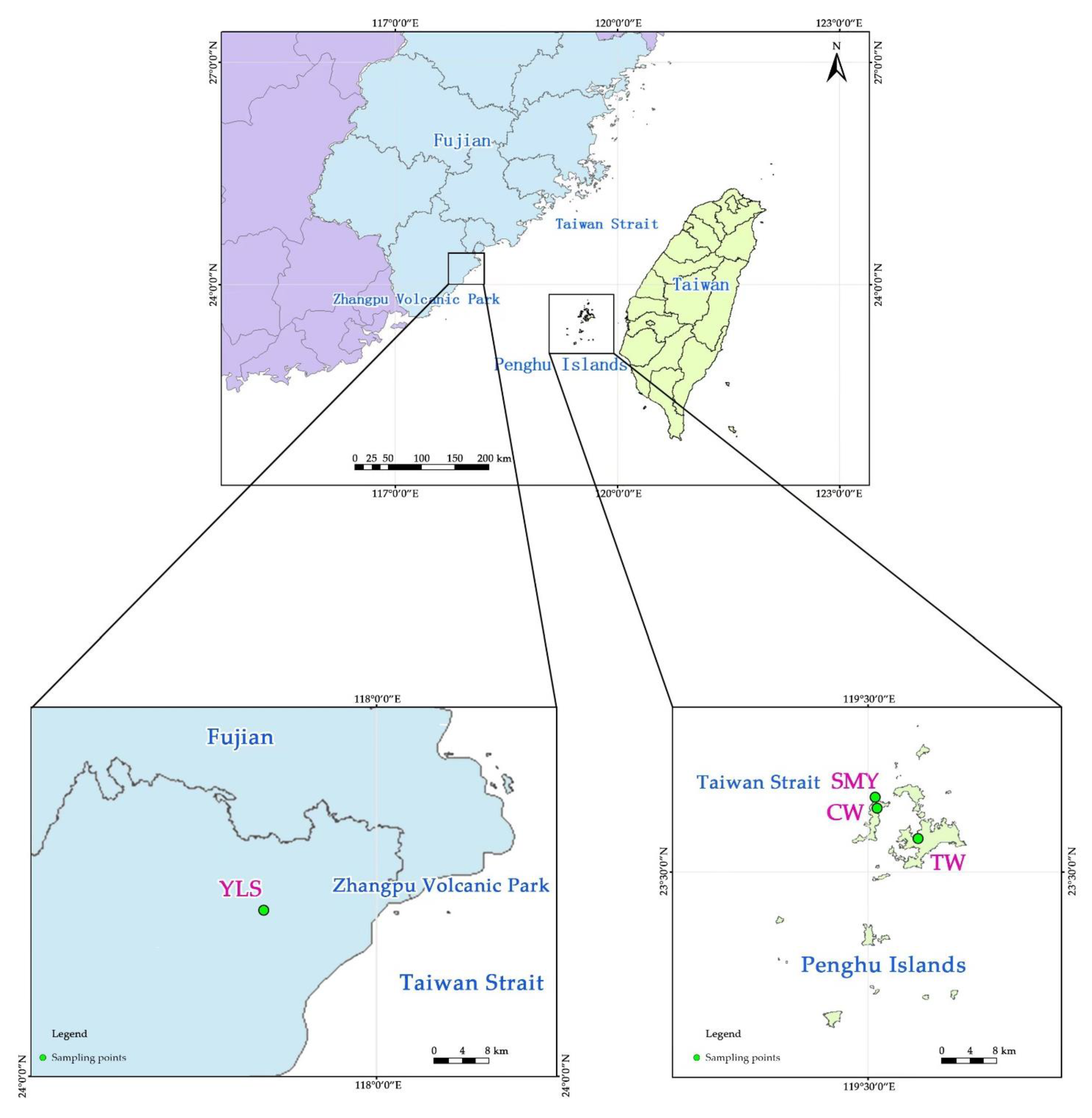
2. Materials and Methods
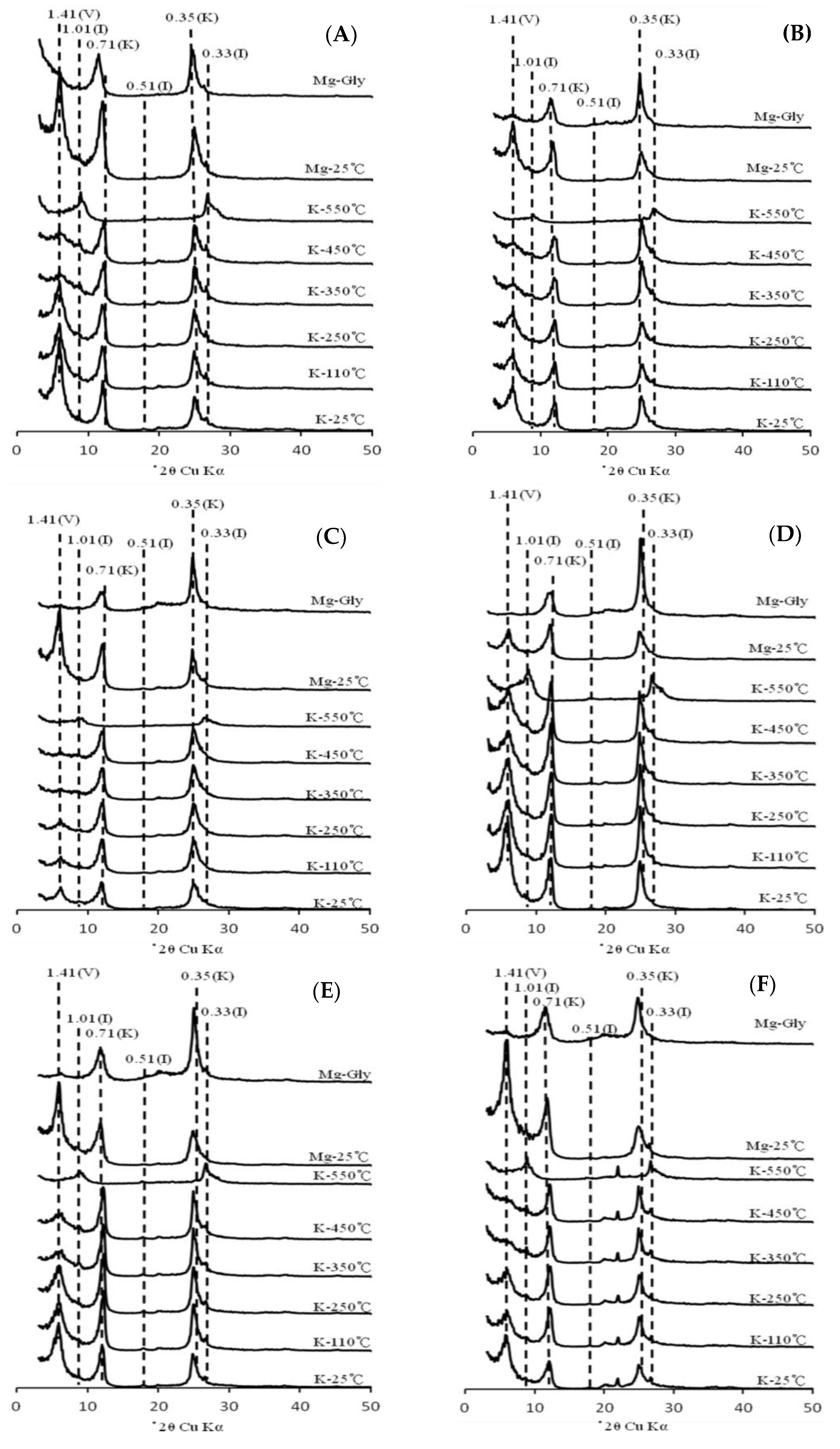
The annual precipitation of the study area was approximately 1013 mm, with approximately 70% falling during the summer (July and August). The mean annual air temperature was 22.9 °C. Summer rainfall characteristically occurred as thunderstorms and rainfall associated with typhoons and wind in the winter with low soil fertility. The bedrocks of all sample sites consisted of basalts from volcanic eruptions.
Field descriptions of the Anzei (AZ), Siyu (SY), Chianmei (CM), Tong Wei (TW), Chu Wan (CW) and Shiao Men Yu (SMY) paleosols were outlined by Wang et al. [8,9]. The TW pedon had well-developed pedogenic features, such as prismatic soil structures, soil horizons and yellow–red to dark reddish colors (5 YR or 7.5 YR). At depths from 405 to 483 cm, there was a clay- and free Fe-oxide (Fed)-enriched horizon, suggesting that this part of the profile was a former pedon that was covered by basaltic lava.
The CWI, CWII and SYM paleosols buried by the late Miocene basalts were morphologically similar to three distinctive layers. Some fossil root traces were detected in the uppermost layer [8]. In the CWI and CII profiles (late Miocene), the clay contents throughout the profiles ranged from 40% to 83% [7]. The pedon had dark reddish colors (10R 3/4 to 10R 4/8), darker than the TW (early Quaternary) pedon. The Fed contents in the CW pedon were slightly greater than those in the TW pedon, suggesting that it was more intensely weathered in the late Miocene climate.
Two late Miocene paleosols, three layers of the intergrade red soils (irs) from CW (CW(irs)) and SMY (SMY(irs)), overlaid on CWI (separated into 17 horizons) and CWII (separated into 20 horizons), early Quaternary red soils of the TW (separated into 11 horizons) and another reference TW pedon (A, B1 and B2 soil horizons); the A horizon of the AZ, Hsi Yu (HY) and CM soils on the Penghu Islands were also collected for comparison. The CW(irs) paleosol was overlaid by one layer, 5 to 7 m in thickness, of onion-like intense weathered basalts. Both paleosols were conspicuously reddish in color (Munsell soil color 10R) [8,18]. The Yulinshi (YLS) pedon was located near the Zhangpu Volcanic Park and was also collected for this study (Figure 2). The YLS paleosols were separated into six layers; we collected six horizons of paleosols, i.e., 0–2 (1), 2–20 (2), 20–40 (3), 40–60 (4), 60–80 (5) and >80 (6) cm, 11 layers, i.e., 0–2, 2–10, 10–20, 20–30, 30–40, 40–50, 50–60, 60–70, 70–80, >80 cm, and rock.
Three layers (layers 1, 2 and 3) of the deposited soil sediments (irs) in the CWI(irs), CWII(irs), and SMY(irs) between 10 and 12 Ma basaltic eruptions were collected for this study. The late Miocene paleosols were moderately kaolinized and classified as fine, kaolinite, hyperthermic and Typic Rhodic Paleustalf [19]. Two paleosols from the Penghu Island groups were located in the range of latitudes 23°34′ N and 23°38′ N and longitudes 119°35′ E and 119°29′ E, respectively. The distance between these two paleosols was approximately 1 km (Figure 1B). The YLS paleosol was located at 24°11′ N and 117°52′ E in the Zhangpu volcanic area and classified as fine, mixed, hyperthermic and Typic Rhodistalf (Figure 1E).
Soil samples were air-dried, ground and passed through a 2 mm sieve and stored in plastic bottles. The organic carbon content was determined with a CHN analyzer (Carlo Erba nitrogen analyzer). The soil pH was determined in a 1:5 (w/w) slurry of soil and deionized water using the glass electrode method. The particle size distribution was determined through the use of the pipette method [20]. The free iron oxide contents (i.e., Fed and Ald) were determined with the citrate–bicarbonate–dithionite method of Mehra and Jackson [21].
Samples for the elemental analysis were ground to pass a 0.105 mm sieve and analyzed using inductively coupled plasma-atomic emission spectrometry (ICP-AES, Perkin-Elmer, Waltham, MA, USA, model Optima 2000 DV, NY) after microwave digestion in an aqua regia/hydrofluoric acid mixture. Powder X-ray diffraction (XRD) of the sand, silt and clay fractions was carried out with a Rigaku Geigerflux X-ray diffractometer with CuKα radiation (current 15 mA, tube voltage 35 kV). A Ni filter was used on the oriented specimen. The YLS (1 to 6) paleosol samples were removed from organic matter using a 30% H2O2 solution, heated at 70 °C, treated with a dithionite–citrate–bicarbonate solution to remove free sesquioxides and then dispersed and fractionated into 2 µm clays. The K- and Mg-saturated clays were examined using heating treatments at 110°, 250°, 350°, 450° and 550 °C and glycerol salvation [22]. The cation-exchange capacity was used to semiquantitatively analyze smectite [18]. Kaolinite was estimated from the XRD peak intensity at 0.71 Å [23]. The illite contents were estimated through the potassium compositions. One drop of clay suspension was added to a carbon-coated grid, which was stored in a desiccator under vacuum for 1 d. The operating voltage for the transmission electron microscope (TEM) analysis was 75 kV. A Hitachi H-7100 TEM was employed to differentiate 7 Å halloysite from kaolinite, according to the particle morphology.
The chemical index of weathering (CIW) was calculated using major element chemistry. Harnois [24] defined the CIW as follows:
CIW = ( Al 2 O 3 Al 2 O 3 + CaO + Na 2 O ) × 100 %
The abundances of kaolinite and smectite or vermiculite in the clay fractions of the red soil of the CW, AZ, CM, TW (early quaternary), Penghu and YLS (Zhangpu) profiles were also semiquantitatively determined from X-ray diffractograms using the following formulae:
Kaolinite = ( Hk 001 × Wk 001 Hk 001 × Wk 001 + Hs 001 × Ws 001 ) × 100 %
Smectite = ( Hs 001 × Ws 001 Hk 001 × Wk 001 + Hs 001 × Ws 001 ) × 100 %

3. Results

The soil pH and Fed and clay contents of the CW(irs) and SMY(irs) of the intergrade red soils ranged from 6.6 to 7.1, from 5.8 to 9.8 g kg−1 and from 39.1% to 82.3%, respectively (Table 1). The soil pH ranged from 6.1 to 8.0 in the early Quaternary red soils of the TW pedons and from 6.6 to 8.0 in the CWI and CWII profiles, with low contents of organic carbon [7]. The Fed contents of the TW pedons ranged from 2.21 to 10.7 g kg−1. A high accumulation of Fed contents in the 20–40 cm of the CWI and CII pedons was correlated to the 10R of the Munsell soil color chart. The Fed contents in the CWI pedon were slightly higher than those in the CII pedon. Low amounts of Ald were present in the CWI, CWII and TW pedons [7]. The soil pH of the CW(irs) and SMY(irs) pedons was in the neutral range, with high clay contents. The soil pH and clay contents of the YLS paleosols ranged from 5.8 to 6.2 with neutral conditions and from 21.2(%) to 33.8(%), respectively (Table 1). The organic carbon contents of the CW(irs) and YLS pedons ranged from 0.3 to 4.5 g kg−1 and from 10.4 to 56.6 g kg−1, respectively. The organic carbon content decreased with increasing soil depth. The Fed concentrations of the CW(irs) and SMY(irs) pedons ranged from 6.8 to 9.8 and from 4.7 to 6.1 g kg−1, respectively. The Fed concentrations of the YLS pedon ranged from 79.2 to 131.5 g kg−1 (Table 1). The Fed concentrations were much higher than those of the CW(irs)# and SMY(irs). The quartz, feldspar, magnetite, kaolinite (halloysite), vermiculite and hematite of clay minerals were the major mineralogical components.
There were minor amounts of quartz and feldspar in coarse fractions of both CW and SMY paleosols of the late Miocene eruption, as determined with a powder X-ray diffraction analysis. There was no illite, smectite, vermiculite, chlorite or mixed-layer clays present in the paleosol profiles. Two distinctive layers (layers one, two and three) appeared in each CW(irs) and SMY(irs) late Miocene soil sediment between 12 and 10 Ma of basaltic eruptions (i.e., Penghu paleosols). In the three layers (one, two and three) in descending order, the clay contents in the CW(irs) and SMY(irs) pedons ranged from 39.1% to 82.3%, respectively (Table 1). The powder XRD analysis showed that 7 Å-halloysite was present in the top layer (layer one), and that the order/disorder of kaolinite was present on layers two and three of the CW(irs) and SMY(irs) pedons. The relative crystallinity of KGa-1 (reference kaolinite supplied by the Clays and Clay Minerals Society) was 79.5 (R elative crystallinity = (001 peak height) ÷ (width at 1/2 peak height)). The CW(irs) and SMY(irs) were hexagonal-like, platy kaolinites (0.1–0.2 µm in diameter) and spheroidal, hollow 7 Å-halloysite (layer one), determined with the use of TEM investigations [8].
The soil pH, organic carbon and CaCO3 contents of the reference TW pedon (A, B1 and B2 soil horizons, and of early Quaternary age) and the horizon of the AZ, SY and CM soils ranged from 7.1 to 8.2, from 1.2% to 41.1% and from 0.8% to 45.7%, respectively.
The soil texture ranged from clay, clay loam, silty loam and sandy clay loam with base saturation and cation exchange capacities ranging from 86% to 100% and from 11.7 to 41.1 cmol(C) kg−1, respectively. The dithionite–citrate–bicarbonate extracted Fed and Ald ranging from 8.4 to 107.0 and from 4.1 to 9.7 g kg−1, respectively [18]. In general, the clay contents in the late Miocene in the Penghu Islands were higher than those of the YLS pedon in the Zhangpu volcanic area; however, the sand showed the reverse trend (Table 1).
Oriented slides of the XRD analysis with K- and Mg-saturated clay of the reference TW (TWI, A, B1 and B2 horizons, and of early Quaternary age) and A horizon from the AZ, SY and CM paleosols (Penghu Island) showed that kaolinite, illite, smectite and vermiculite were present in the soil clays. Greene-Kelly tests indicated that these smectites were tetrahedral-substituted beidellite or nontronite, due to the lack of Si in the basalt rock. The mean layer charge of these smectites ranged from 0.48 to 0.52 cmol(c)/O10(OH)2 [18,25,26].
X-ray diffractograms showed both kaolinite and smectite in the clay fractions of the TW pedon. From the semiquantitative analysis, approximately 48% to 95% of the clay reached maximum at 405 and 460 cm [7]. In general, kaolinite contents decreased and smectite increased with increasing soil depth [8]. Although kaolinite and smectite coexisted in the TW pedon, they could have formed in different soil environments. Kaolinite booklets were observed in the silt fractions of the CWI and CII pedons. The major elemental compositions in all soil samples could be divided into three groups according to their abundance: (I) Fe, Al and Si; (II) Ti and Mg; and (III) Ca, Mn, Na and K. The amounts of group I elements were much greater than those of other groups [9]. This finding was characteristic of lateritic soils, resulting from prolonged weathering.
The Ti concentration was fairly constant with increasing soil depth. The Ti concentrations in the YLS pedon were slightly low than those of the SMY(irs) pedon (Table 2). The Mg concentration was much more abundance than that of K, Ca and Na in the CWI, CII (late Miocene) and TW (early Quaternary age) pedons. We suggest that these results were attributed to the influx of seawater in the profile and the subsequent fluctuation of the groundwater level. The Mn concentration also showed a large peak at 500 cm. The elemental distribution in the late Miocene paleosols (CWI and CWII) was also variable.
The Ca concentration on the uppermost horizon in the TW pedon (early Quaternary) was greater than that of all lower horizons [9], because of its fossil shell fragment contents. In the same pedon, there were two peaks for the Mg concentration at a depth of 200 cm. The K2O, CaO and MgO contents in the YLS pedon were higher than those of the SMY pedon (Table 2). The Na2O contents showed the reverse trend. The Fe2O3 and MnO concentrations at SMY and YLS were approximately the same. The SiO2 concentrations of the YLS pedon were greater than those of the SMY pedon, and the Al2O3 concentrations showed different trends. Late Miocene paleosols (i.e., SMY pedon) contained more clay, less SiO2/Al2O3 and a higher chemical index of weathering (CIW) than those of the YLS pedon.
The soil physical and chemical properties of the Zhangpu (i.e., YLS) paleosols were similar to those of the Penghu paleosols. The soil texture of the YLS paleosols ranged from sandy sand, sandy clay, sandy loam, sandy clay loam to sand clay (Table 1). X-ray diffraction patterns of the YLS paleosol clays are shown in Figure 3. X-ray diffraction patterns of the Zhangpu (YLS) clays indicated the presence of kaolinite, illite and vermiculite. The semiquantitative clay minerals are summarized in Table 3. There was only tetrahedral-substituted smectite (i.e., nontronite or beidellite) present in the AZ, SY, CM and TW paleosols (Penghu Island) due to the lack of Si, which developed due to the early Quaternary basalt rocks. Smectite clay was characterized by the Greene-Kelly test of a LiNO3 solution and alkylammonium [18,25,26,27]. Kaolin clays were only present in the CW and SMY paleosols of the late Miocene.

4. Discussion

4.1. Chemical Index of Weathering (CIW) Values

Due to the low amounts of Na and Ca elements in the pedons, all CIW values were very large, indicating that the mobile base elements were strongly depleted during soil formation compared with Al [9]. For the TW pedon, the CIW values ranged from 88.9% to 97.8%. The A horizon (0–15 cm) contained more Ca than the lower soil horizons and, consequently, had smaller CIW values than those below the basaltic parent materials. The CIW values of 96.2 to 97.8 between 15 and 483 cm indicated that the TW pedon was intensively weathered. However, the CIW values of the CWI and CWII samples were even greater than that of the TW pedon. The CIW of the SMY paleosols ranged from 94.7% to 96.7%, also indicating a high weathering sequence. However, the CIW values of the YLS paleosols in the Zhangpu volcanic district were in the range from 89.7% to 96.5%, which was close to the Penghu Islands. This result was consistent with the field observations and mineral assemblages. The pH of the TW, CWI and CWII pedons ranged from 6.1 to 8.0 [7]. The soil pH of the surface horizon (0–15 cm) was 8.0. This finding suggested the possibility of seawater intrusions in the past [7]. Of course, global changes in the past merit further research.

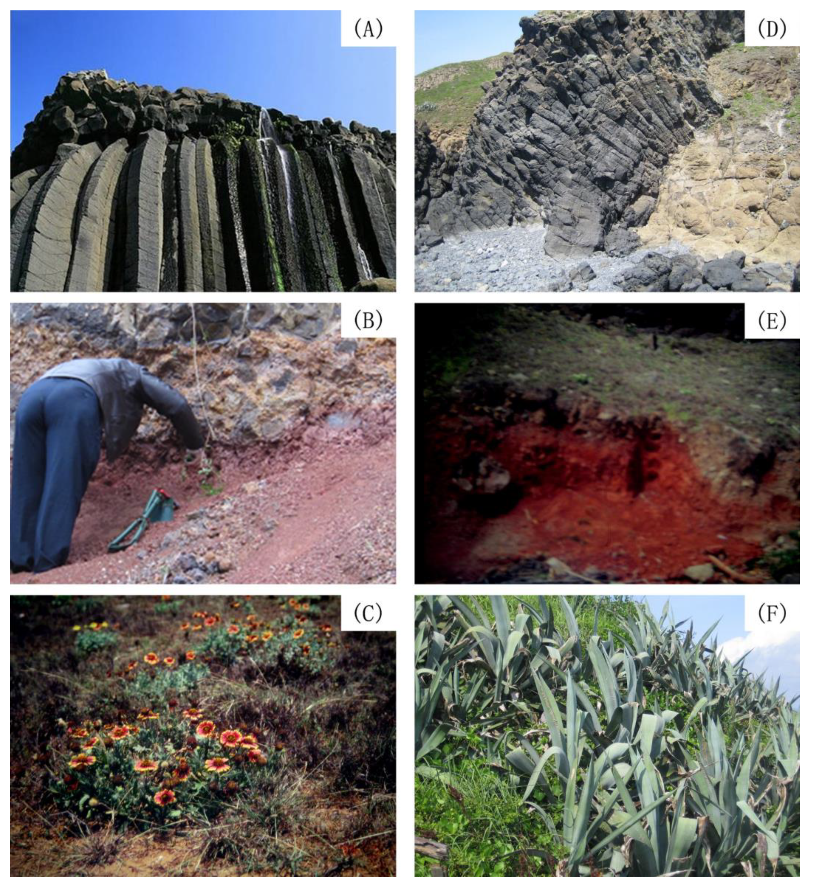
4.2. Geological Settings of the Penghu Islands and Zhangpu Volcanic Park

The Penghu Islands in the Taiwan Strait exposed basalts of Pleistocene age, as given in earlier reports. The age of the basalts was recently dated to the Miocene through the use of the K–Ar method. These basalts covered the entire island group and formed flat-topped tablelands, reaching a maximum elevation of 50 m above sea level. Horizons of sand, clay and carbonized wood fragments were interbedded with basalt flows. The sediments contained mollusks and foraminifera, indicating a reported Pleistocene age and a shallow marine environment. Recent paleotectonic studies have suggested that these fossils may be older, possibly Pliocene or even late Miocene, with further studies, thus, needed. The Penghu basalt and its associated extensive plateau sediments were believed to form a thin blanket directly overlying the basement, which was exposed on Hua Yu Island. This basement comprised quartz porphyry with quartz veins and xenoliths of phyllite and orthoquartzite, and yielded a radiometric age of 55 Ma [28,29,30]. This porphyritic rock was considered to be related to the granite batholith exposed in Fujian. Eastward of the main islands to the Penghu Islands, a thin wedge of Neogene sediments generally intervened between the basalt flows and the basement. One hole drilled on Penghu recorded 320 m of basalt overlying approximately 200 m of Neogene sediments, which, in turn, overlaid a Miocene basement composed of indurated siliceous shale and quartzite [6].

4.3. Oceanic Trench Biota of the Penghu Island Group and Zhangpu Volcanic Area

The large amount of ice formed during the Ice Age siphoned off only an average depth of approximately 80 m, allowing for previously independent biota to be covered. The large amount of ice covered the Taiwan Strait and Penghu trench, forming a continent [6]. Fossils discovered in Penghu and southern parts of Taiwan revealed the migration of elephants, buffalos, Pere David’s deer and the axis from northern mainland. As the Ice Age ceased as Earth’s temperature rose, so did the sea level, submerging the land and fossilized animals between the mainland and Taiwan to form what is currently the Taiwan Strait [6]. Due to the strong current, many buried fossils washed up into the sea trenches between Penghu and Taiwan. The number of fossils has increased over time.
The Penghu oceanic trench biota and local geology settings revealed that there was an event at the end of the last Ice Age (i.e., one to three Ma) that formed a Tungshan land-bridge between the mainland and Taiwan (http://www.fjbwy.com.index.asp (22 February 2020) and http://www.ntm.gov.tw (22 February 2020)); [7]. Thus, we speculated that it was continental land during the Ice Age. More in-depth research on the history of global climate changes is needed.

4.4. Mid-Miocene Zhangpu Biota Reveals a Rich Rainforest Biome in Penghu, Taiwan

Based on material preserved in amber and associated sedimentary rocks from southeastern China, Wang et al. [31] reported a rich middle Miocene rainforest biome, the Zhangpu biota (e.g., 14.7 Ma ago), which showed that the mid-Miocene rainforest reached 24° N to the east and was more widespread than previously estimated. Their results may be indicative of not only the highlighted role of tropical forests, acting as evolutionary museums of biodiversity at a generic level, but also suggest that the mid-Miocene climate optimum (MMCO) probably strongly shaped the east biota via the northern expansion of the megathermal rainforest biome, especially in Penghu, Taiwan. The Zhangpu provided an ideal snapshot for biodiversity redistribution during global warning, and further in-depths studies are needed.

5. Conclusions

The whole-soil major element chemistry and mineral assemblages indicated that the moderately laterized CWI, CWII, CW(irs), SMY and SMY(irs) (late Miocene) paleosols were slightly more intensely weathered than the AZ, SY, CM, TW (early Quaternary) and YLS paleosols. However, pedogenesis continued in the TW pedon through the Quaternary age, whereas all the CW and SMY profiles were buried by the upper basalt, thus, terminating the pedogenic processes. An investigation of whole-profile chemistry and field observations implied that during the soil-forming processes, the high sea level, tide and episode input some nonpedogenic materials into the profiles that could have influenced the soil-forming processes in the Penghu Islands and Zhangpu volcanic district.
The kaolinite and smectite mineralogy and physical and chemical properties of the paleosols and landscapes in the Zhangpu volcanic area, Fujian, were similar to those of paleosols on early Quaternary (i.e., TW) sediments on the Penghu Islands, Taiwan. From the Penghu oceanic trench biota and local geology settings, we speculated that it was a continental land during the Ice Age. The marine geology, tectonics and landscape between the Penghu Islands of Taiwan and Zhangpu Volcanic Park, Fujian, of the Taiwan Strait, merit further exploration on the history of global climate change. On the other hand, the Zhangpu Volcanic Park is a reserved district that covers an area of approximately 318 km2. It was not easy and legal to collect proper paleosols for this study. Thus, further in-depth research is encouraged to expand the collection of rock and paleosols beyond the territory of the National Park.

Author Contributions

All authors contributed to the study conception and design. The material preparation, data collection, data analysis and revision of figures were performed by X.L. and M.W. The first draft of the manuscript was written by M.W., with help from X.L. and W.W.; L.D. and C.O. helped in the collection of paleosols and soil analyses. All authors commented on previous versions of the manuscript. All authors have read and agreed to the published version of the manuscript.

Funding

This study was supported by the projects NSC 96-2313-B-002-021 of the National Science Council, Taiwan, and CXTD2021009-1 of the Fujian Academy of Agriculture Sciences, Fujian.

Data Availability Statement

The datasets used and/or analyzed during the current study are available from the corresponding author on reasonable request.

Acknowledgments

This article dedicate to Zhu Hejian, Fujian Normal University, Fuzhou, Fujian province, China.

Conflicts of Interest

The authors declare that they have no known competing financial interests or personal relationships that could have appeared to influence the work reported in this paper.

References

  1. Chen, P.Y. A Review and Discussion about the Stratigraphic Subdivisions and Some Problems Concerning the Structural of the Penghu Islands; Special Issue No. 6; Central Geological Survey: Taipei, Taiwan, 1992; pp. 9–38.
  2. Wang, W.M.; Yeh, H.W.; Wang, M.K.; Chen, P.Y. A study of some palesols in Penghu Islands. J. Chin. Agri. Chem. Soc. 1996, 34, 417–428, (In Chinese with English Abstract). [Google Scholar]
  3. Lee, C.Y. Chronology and Geochemistry of Basaltic Rocks from Penghu Islands and Mafic Dikes from East Fujian: Implications fro the Mantle Evolution of SE China since Late Miocene. Ph.D. Thesis, Graduate Institute of Geology, National Taiwan University, Taipei, Taiwan, 1994; 226p. [Google Scholar]
  4. Van Houten, F.B. Climatic significance of red beds. In Descriptive Paleoclimatology; Nairn, A.E.M., Ed.; Interscience Publication: New York, NY, USA, 1961; pp. 89–139. [Google Scholar]
  5. Jenny, H. Pedogenesis of horizons and profiles. In The Soil Resource, Origin and Behavior; Jenny, H., Ed.; Springer: New York, NY, USA, 1980; 175p. [Google Scholar]
  6. Ho, C.S. An Introduction to the Geology of Taiwan Explanatory Text of the Geologic Map of Taiwan. In Central Geological Survey; The Ministry of Economic Affairs: Taipei, Taiwan, 1988; 192p. [Google Scholar]
  7. Wang, W.M. The Comparative Study of the Geochemistry and Weathering Chemistry of the Modern Soils and the Late Miocene Palesols in the Penghu Islands (Pescadores), Taiwan. Ph.D Thesis, National Taiwan University, Taipei, Taiwan, 1997; 166p. [Google Scholar]
  8. Wang, W.M.; Yeh, H.W.; Chen, P.Y.; Wang, M.K. Kaolin mineralogy of clays in paleosol, profiles on the late-Miocene sediments in Penghu Islands (Pescadores), Taiwan. Clays Clay Miner. 1998, 46, 1–9. [Google Scholar]
  9. Wang, M.K.; Wang, W.M.; Chiang, P.N.; Chen, Y.M.; Chang, C.M. Clay mineralogy and major element chemistry of the early quaternary and Late Miocene paleosols on Penghu Islands (Pescadores), Taiwan. Soil Sci. 2007, 172, 486–498. [Google Scholar] [CrossRef]
  10. Leung, K.W.; Lai, C.Y. Soil development study of the reddish brown lateric soils in Penghu County, Taiwan, China. J. Taiwan Agric. Res. 1965, 14, 1–14, (In Chinese with English Abstract). [Google Scholar]
  11. Zhu, H.J.; Tan, B.H.; Chen, J.F.; Zheng, J.M.; Jiang, Y.F. Properties, formation and fertility of Vertisol in Fujian Province. Pedosphere 1995, 5, 11–20. [Google Scholar]
  12. Lin, C.C.; Chiu, Y.; Lu, H.C.; Huang, T.Y. Geology and minerals resources of the Penghu Island Group. Taiwan Min. Ind. 1957, 9, 26–38. [Google Scholar]
  13. Lu, Q.D.; Zhu, G.L.; Qin, Z.Y. Geochemical feature and genesis of the Mesozoic and Cenozoic basalt in Fujian Province. Region. Geol. China 2000, 19, 85–91, (In Chinese with English Abstract). [Google Scholar]
  14. Fujian Local Chronicles Compilation Committee. Chronicle of Fujian Province - Chronicle of Geology and Mineral Resources.; China Local Records Press: Beijing, China, 1996. (In Chinese) [Google Scholar]
  15. Fan, Q.C. Correlation of Cenozoic basalt in Fujian-Taiwan area. J. Oceanogr. Taiwan Strait 1987, 6, 174–179, (In Chinese with English Abstract). [Google Scholar]
  16. Sun, D.X.; Lu, T.Y.; Shen, X.L.; Xu, L. High-precision lazer “40Ar/39Ar age of volcanic rocks in Longhai-Zhangpu area, Fujian Province. Geol. Bull. China 2019, 38, 1511–1520. [Google Scholar]
  17. Zheng, D.R.; Shi, G.; Zhang, H.C.; Wang, W.M. Age constraints on Neogene tropical rainforest in China and its relation to the Middle Miocene Climate Optimum. Palaeogeogr. Palaeoclimatol. Palaeoeclogy 2019, 518, 82–88. [Google Scholar] [CrossRef]
  18. Pai, C.W.; Wang, M.K.; Wang, M.W.; Houng, K.H. Smectites in iron-rich calcareous soil and black soils of Taiwan. Clays Clay Miner. 1999, 4, 389–398. [Google Scholar]
  19. Soil Survey Staff. Keys to Soil Taxonomy, 9th ed.; US Department of Agriculture, NRCS: Washington, DC, USA, 2006.
  20. Gee, G.W.; Bauder, J.W. Particle-size analysis. In Methods of Soil Analysis. Part 1: Physical and Mineralogical Methods; Klute, A., Ed.; America Society Agronomy Monograph, 9; Academic Press: Madison, WI, USA, 1986; pp. 383–411. [Google Scholar]
  21. Mehra, O.P.; Jackson, M.L. Iron oxide removal from soils and clays by a dithionite-citrate system buffered with sodium bicarbonate. Clays Clay Miner. 1960, 7, 317–327. [Google Scholar] [CrossRef]
  22. Jackson, M.L. Soil Chemical Analysis. Advanced Course, 2nd ed.; University of Wisconsin: Madison, WI, USA, 1979. [Google Scholar]
  23. Brindley, C.W. Quantitative X-ray minerals analysis of clays. In Crystal Structures of Clay Minerals and Their X-ray Identification; Brindley, G.W., Brown, B., Eds.; Monograph No. 5; Mineralogical Society: London, UK, 1980; pp. 411–438. [Google Scholar]
  24. Harnois, L. The CIW index: A new chemical index of weathering. Sedim. Geol. 1988, 55, 319–322. [Google Scholar] [CrossRef]
  25. Pai, C.W.; Wang, M.K.; King, H.B.; Chiu, C.Y.; Hwong, J.-L. Hydroxy-interlayered minerals of forest soils in A-Li Mountain, Taiwan. Geoderma 2004, 123, 245–255. [Google Scholar] [CrossRef]
  26. Pai, C.W.; Wang, M.K.; King, H.B.; Hwong, J.L. Layer charges of vermiculite in two forest Inceptsols in northern Taiwan. Clay Miner. 2006, 41, 587–596. [Google Scholar] [CrossRef]
  27. Greene-Kelly, R. Identification of montmorillonites. J. Soil Sci. 1953, 4, 233–237. [Google Scholar] [CrossRef]
  28. Lin, Y.K. Cenozoic basalts and their volcanism in Tian, a-Niutou Shan area, Fujian Province. Acta Ptrologica Sinca 1992, 8, 376–385, (In Chinese with English Abstract). [Google Scholar]
  29. Jahn, B.M.; Chen, P.Y.; Yen, T.P. Rb-Sr ages of granitic rocks in southeastern China and their tectonic significance. Geol. Soc. Am. Bull. 1976, 86, 763–776. [Google Scholar] [CrossRef]
  30. Jahn, B.M.; Zhao, X.H.; Li, J.L. Formation and tectonic evolution of southeastern China and Taiwan. Isot. Geochem. Constrains Tectonophys. 1990, 183, 145–160. [Google Scholar] [CrossRef]
  31. Wang, B.; Shi, G.; Xu, C.P.; Spicer, R.A.; Perrichoy, V.; Schmidt, A.R.; Peng, H.; Liu, X.Y.; Gao, T.P.; Wang, Z.X.; et al. The Mid-Miocene Zhangpu biota reveals and outstandingly rich rainforest biome in East Asia. Environ. Stud. Sci. Adv. 2021, 7, eabg0625. [Google Scholar] [CrossRef] [PubMed]
Figure 1. Columnar basaltic eruptions, paleosol structures and vegetation of the Penghu Islands (AC) and Zhangpu volcanic area (DF) (courtesy of https://zh.m.wikipedia.org (22 December 2022) and https://baike.baidu.com (22 December 2022)).
Minerals 13 00531 g001
Figure 2. The distance between the Penghu Islands and Zhangpu volcanic area is approximately 180 km. The Penghu Islands are located on the east side of Zhangpu volcanic area. CW: Chu Wan; SMY: Shiao Men Yu; TW: Tong Wei (Penghu); YLS: Yulinshi (Fujian).
Minerals 13 00531 g002
Figure 3. X-ray diffraction patterns of the (A) YLS (1), (B) YLS (2), (C) YLS (3), (D) YLS (4), (E) YLS (5) and (F) YLS (6) clay samples. Note: I: illite; K: kaolinite; V: vermiculite.
Minerals 13 00531 g003
Table 1. Selected soil physical and chemical properties of the late Miocene sediments in the CW(irs), SMY(irs) and YLS pedons.
PedonDepthpH *CFedParticle Size AnalysisMineral
SandSiltClay
cm g kg−1g kg−1 %
CW(irs)#
10–306.64.59.828.032.339.7H, Q, F, He *
230–607.00.66.9<3.016.380.4K, Q, F, He
3>606.50.36.831.028.350.7K, Q, F, He
SMY(irs)
10–246.8- *4.726.63539.1H, Q, F, He
224–727.1-5.8<2.015.582.3K, Q, F, He
3>726.6-6.14.827.567.5K, Q, F, He
YLS
10–26.056.679.253.025.921.2K, Q, F, V, He
22–205.930.5108.148.129.422.5K, Q, F, V, He
320–405.823.1120.752.523.723.8M, K, Q, F, He
440–605.918.0131.540.329.129.8M, K, Q, F, He
560–805.815.6127.040.226.133.8M, K, Q, F, He
6>806.210.4107.363.213.023.8M, K, Q, F, He
*-: not detected; F: feldspar; H: halloysite; He: hematite; K: kaolinite; M: mica; Q: quartz; V: vermiculite.
Table 2. Chemical and elemental concentrations of the late Miocene sediments in the SMY and YLS pedons.
PedonDepthK2ONa2OCaOMgOFe2O3MnOAl2O3SiO2TiO2
cm%
SMY#0–50.422.060.030.9012.050.3227.2836.164.79
5–80.252.060.020.6912.080.2230.8735.974.79
8–120.242.090.020.6812.120.1830.1839.424.55
12–150.232.210.030.7112.450.1931.0739.454.22
15–200.252.210.030.8013.510.2531.8639.314.11
20–250.262.230.040.7816.690.4031.3338.994.04
25–300.252.320.030.6215.240.1725.5738.474.84
30–350.262.060.030.6713.560.2731.9140.504.03
35–400.251.920.050.7015.950.4129.8038.623.91
40–500.231.870.040.7018.820.5229.3536.814.00
50–600.222.010.050.7216.850.2830.4639.863.82
60–700.211.900.040.7417.000.2031.4939.714.01
70–800.221.750.040.6616.200.2631.9540.973.84
YLS0–21.531.052.231.8614.570.2216.2241.283.38
2–101.420.891.311.6616.080.2318.0442.223.82
10–201.380.771.101.6516.460.2318.1842.773.82
20–301.220.710.811.5717.100.2218.7641.593.78
30–401.200.781.131.7817.060.2119.2241.773.60
40–500.970.580.841.6417.230.1919.8340.503.30
50–600.920.550.781.7517.390.1820.1141.233.17
60–700.860.540.761.7917.340.1820.5040.923.03
70–800.890.560.901.9716.870.1820.7241.542.83
>801.110.911.842.5214.730.1620.6443.522.30
Rock2.002.967.656.5611.480.1615.4048.792.26
Table 3. Semiquantitation of the CW(irs), SMY(irs) (Penghu Islands) and YLS (Zhangpu, Fujian) soil clay minerals using XRD diffraction analyses.
PedonDepthKaoliniteIlliteSmectiteVermiculite
cm
CW(irs)0–30++++++ *---
30–60++++++---
>60+++++++---
SMY(irs)0–24++++++---
24–72++++++---
>72+++++++---
YLS0–2+++++++-+++
2–20++++++-++++
20–40++++++---
40–60+++++---
60–80++++---
>80+++++++---
* Symbol of “-”: not detectable through semiquantitation of XRD reflection peaks. +: 0%–10%; ++: 10%–20%; +++: 20%–30%; ++++: 30%–40%; +++++: 40%–50%; ++++++: 50%–60%; and +++++++: 60%–70%.
Disclaimer/Publisher’s Note: The statements, opinions and data contained in all publications are solely those of the individual author(s) and contributor(s) and not of MDPI and/or the editor(s). MDPI and/or the editor(s) disclaim responsibility for any injury to people or property resulting from any ideas, methods, instructions or products referred to in the content.

