1. Introduction
Mali is located in the West African Craton (
Figure 1), hosting thirteen gold mine sites. There are several gold projects under development (Seribaya, Wiliwili, Sitakily, Dandôko, Baboto, Hamdallaye, Bourdala, etc.). It is the third highest African gold producer and contributes to world production. Eight of the industrial gold mines are located in Western Mali. Today, gold represents 7% of the global gross domestic product (GDP); therefore, it has an important place in Mali’s socio-economic development. There are several others unknown structures controlling gold indications under laterite cover, which is generally thick. Known exploration methods are sometimes inappropriate for characterizing structures related to gold mineralization under laterite cover, which handicap new gold deposit discoveries.
To assist gold exploration in the Kedougou-Kenieba Inlier (KKI), recent studies, using geological [
1,
2,
3,
4,
5,
6,
7,
8] and geophysical methods [
9,
10,
11,
12], have identified numerous gold bearing structures in different directions (N-S, NE-SW, NW-SE, and in some localities are E-W). Some of these structures are not spatially related to gold. The Malian government and its partners have initiated geological mapping at a scale of 1/200,000 combined with regional geophysical airborne surveys and geochemical sampling [
6,
13]. The geodatabase gathered during these projects has helped to discover the Gara, Kofi, Diambaye I and II, and Fekola gold deposits. Nevertheless, the development of many other gold deposits still remains slow due to the lack of sufficient information on their structural control [
9,
11]. Because of the thick laterite cover, direct exploration methods are often unable to provide the necessary information to understand the behavior of gold mineralization structures in this part of Mali.
For this reason, geophysical methods are mainly used to guide geologists to better understand these structures. These approaches have been utilized in the research for gold deposits [
11,
12,
13,
14]. In areas with thick laterite and silt cover, geophysical methods are more useful in structure characterization and mineral exploration [
10,
11,
14,
15], particularly in Western Mali [
9,
10,
11,
12,
13]. Here, they have played an important role in exploration, from gold showing to gold deposits. Geophysical methods contribute to the identification of shear, silicification, and faults zones, which are generally related to gold mineralization in this part of the West Africa Craton (WAC). Electromagnetic methods have been used for a long time in groundwater investigations. Since the end of the Second World War, this method has been used in mining exploration. Electromagnetic surveying is a useful tool in geological mapping and mineral prospection [
12,
14,
16,
17,
18] through the determination of the conductivity/resistivity of metalliferous structures. EM methods have particular characteristics (coupling to the ground follow, the physical response to pore fluids, and the speed of data acquisition) which are not shared with other geophysical methods [
17]. These particularities give them a veritable asset in exploring natural resources.
In this study, the available airborne electromagnetic method (AEM) data are used to specify structures (shear, silicification, and fault zones) that are strongly associated with gold mineralization. In addition, the quality of the geophysical signatures of these structures has been defined through the analysis of conductivity values. This study aims to guide gold exploration in Western Mali where we have noticed thick laterite and silt cover.
The identified lineaments were ground-proven with the main goal of determining structural trends and their relationship to gold mineralization. This study has allowed for determining the conductive N-S and NE-SW structures held in gold mineralization. These structures have been qualified to be good conductors that characterize the persistence of conductivity in the three orders of electromagnetic signals. Additionally, these structures have mostly coincided with silicification and shear zones in the Kenieba area.
Geological Setting
The West African Craton (WAC) hosts two Precambrian Shields (Reguibat and Leo) and two Precambrian Inliers (
Figure 1), namely Kayes and Kedougou-Kenieba [
1,
6,
11,
19]. The last one hosts the study area (
Figure 1 and
Figure 2), and both inliers appear in the middle of the Paleozoic basin (Taoudeni, Illemeden, etc.). The West African Craton (WAC) is composed of Precambrian formations [
6,
20,
21,
22,
23,
24,
25,
26] which are modeled by Eburnean orogeny, dated to 2.1 Ga [
27].
Figure 1.
Geological map of West African Craton ([
28], simplified).
Figure 1.
Geological map of West African Craton ([
28], simplified).
Essentially composed of Paleoproterozoic formations commonly called Birimian, the Kedougou-Kenieba Inlier (KKI) appeared in the Senegal and Mali territories (
Figure 1 and
Figure 2). The Malian part covers 7200 km
2 and represents 35% of the total area of Kedougou-Kenieba Inlier (KKI). The Birimian formations of this inlier are divided into two main domains: the supergroup of Mako to the west and the one of Dialé-Daléma to the east [
11,
12,
19,
29], separated by the Senegal–Malian Shear-Zone (SMSZ) and the Main Transcurrence Zone (MTZ). The Mako Group is mainly magmatic with some sedimentary heterogeneity (greywackes, sericite bearing schist, etc.) and the one of Dialé-Daléma is mainly sedimentary with some magmatic rocks, such as granite, granodiorite, diorite, etc. [
11,
19,
29]. The sector of Kenieba is located in the Dialé-Daléma supergroup, precisely in the series of Kofi in the east of this supergroup (
Figure 2).
The Kofi group contains two heavy plutonic bodies, which are Gamaye and Yatia [
2], and some doleritic dykes. The age of Gamaye pluton has been defined as 2045 ± 27 Ma [
30]. We also noticed a sedimentary complex zone dominated by carbonate bearing and quartzo-feldspathic rocks [
3,
6]. This complex is associated with mafic dykes and intermediate to acid rocks [
8], and is affected by an intense tourmalinization and albitization [
8,
31]. Albitization was probably produced after a magmatic phenomena because it was only observed along the Senegal–Malian Shear-Zone (SMSZ), as a product of the hydrothermal activities of albitites [
1]. Tourmalinized sandstones are dated to 2093 ± 7 Ma [
32] and are the main facies that host the gold mineralization in Loulo deposits. Many other gold deposits, such as Gara, Kofi, Sitakili, Segala, etc., are situated within the Kofi group (
Figure 2).
MTZ and SMSZ are recognized as major accidents of KKI. These ones and their secondary structures were produced during four tectonic events:
- -
D
1 is described as a compressive phase NW-SE [
2] and is dated at 2070 to 2093 Ma [
33]. It is associated with magmatic accretion [
7];
- -
D
2 dated between 2045 and 1950 Ma [
30], and the D
2 phase is recognized as a senestral overlap with fold deformation [
21,
34,
35,
36]. During this phase, intrusive bodies such as Gamaye pluton take place [
36,
37], accompanying the metamorphism activity [
38,
39]. The SMSZ and MTZ accidents have been linked to this phase [
40];
- -
D
3, with a dextral shearing [
2,
7], started 100 Ma after the D
2 event [
22]. It is associated with extensive deformation in some places of the Diale-Dalema groups [
7]. NE-SW trends have been identified [
1,
7,
11], and also in some places NW-SE trends [
1,
7]. D
3 is thought to control gold mineralization in Loulo deposits [
2] and other places in KKI [
11]. Some of those structures are conductors [
12] and are related to gold mineralization [
11];
The last phase, D
4, has been identified as extensive in the Diale-Dalema basin [
7], and shows the end of Eburnean orogeny.
2. Methodology
The electromagnetic (EM) method is able to characterize groundwater quality in the rock, clay mineral presence, and lithology variation [
41]. In mineral exploration the resistivity depends on the presence of silicification zones and quartz-rich material, while the conductivity is outlined by the presence of sulfide, graphite and others metal-bearing material. The EM data can be collected with the artificial (time domain) or natural (frequency domain) source current. All phenomena of this geophysical method are explained by Maxwell [
42] through four mathematical equations, based on the electromagnetic induction principle:
In this study, airborne electromagnetic methods (AEM) were used in the time domain (TDEM). The AEM was developed after the Second World War for mineral deposit exploration, and became one of the most useful geophysical methods in mineral exploration [
43]. The abundance of artisanal mining sites is an indication of the presence of visible or coarse gold. According to various studies [
12,
44], visible or coarse gold are typical of low-sulfide Au–Quartz veins.
This technique consists of flying over the study area with a helicopter that carries an emitter and receiver (
Figure 3A). The AEM is very efficient in the characterization of conductive bodies [
12,
45], such as massive sulfides. In the Precambrian domain, airborne electromagnetic methods constitute a true asset in identifying fault zones, and conductive and resistive bodies related to gold deposits [
12].
AEM surveys require using a helicopter connected to a current transmitter and Electromagnetic (EM) receiver loop (
Figure 3). The EM data were collected by Fugro Airborne Surveys Corporation, Ottawa, Canada in 2002 with the GEOTEM
® System using the aircraft type CASA-212-200. They were collected for the “Système Minier–SYSMIN” project in Mali funded by the European Community and pre-process using INTREPID
®2005 software. The survey parameters are as follows: flight lines interval—400 m, flight height—120 m, survey line direction—N135°/315°, control lines—N045° with 4000 m line spacing [
13]. These data were collected in the time domain (TDEM) and they involve the primary magnetic field and three orders of conductivity values. The specifications of EM survey data were as follows: basic frequency—75 Hz, impulsion—4 ms, emitter loop—3 turns, dipolar moment—4.65 × 10⁵ Am
2, receptor—sensor with 3 induction coils with sample frequency of 10 Hz corresponding to 6.5 m and 20 channels of measurement.
The measured parameters are the primary field and the conductivity values (electrical field) that contain three orders. The first order has an amplitude between 993.7 and 14,659.9 micro-Siemens. The amplitude range of the second order is between 3130 and 22,397.953 micro-Siemens. For the third order, the amplitude is lower than the previous ranges with values between 153.306 and 909.202 micro-Siemens. The conductance components are calculated through the dipolar moment [
6,
12].
3. Data Interpretation
The conductivity maps (
Figure 4A–C) related to the study area show that high conductance values concentrate in the center and the eastern parts of the Kenieba area. These anomalies are orientated N-S to NE-SW. For low conductivity values, similar directions have been noted mainly in the western part of the study area (
Figure 4A–C). In some places, it is noticed that N-S and NE-SW trends are cross-cut by NW-SE structures. The three conductivity orders give the same forms of anomalies, but the limits and directions are mostly different depending on the magnitude of conductivity order (i.e., first, second and third). A polygonal form can be drawn for some anomalies. The superposition of different directions (
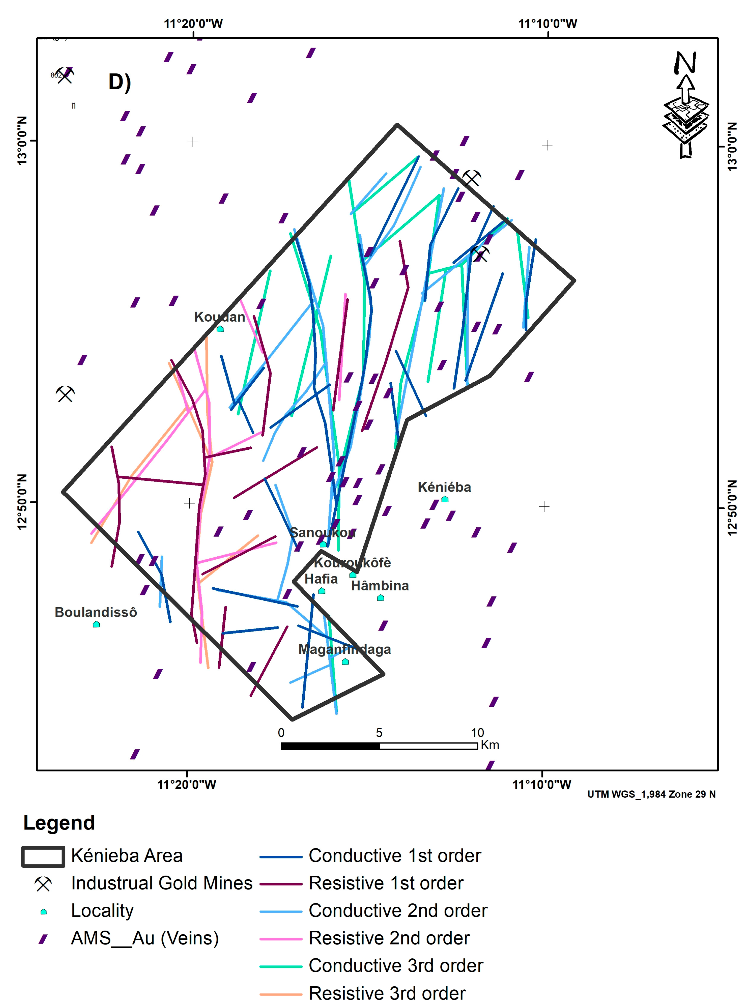
Figure 4D) shows the relevant responses of geological structures. It also proves the efficiency of the airborne electromagnetic method (AEM) in the characterization of conductivity bodies.
For the high conductivity values, anomalies are often not continued but keep the same trend. This is more accentuated in the third-order conductivity map (
Figure 4C). However, the presence of good conductor bodies is observed, and their signal response persists in the three orders conductivity. Previous studies show that in good conductor zones, the secondary field is of long duration [
45]. The high presence of the amplitude in three orders of conductivity proves that the issued signal of geological bodies is saved by a maximum of the channel. Kearey et al. [
45] noted that this is due to deep conductors. The same has been remarked in Kenieba, where conductors can be characterized as deep ones.
Data interpretation was followed by ground proving. During this phase, interpreted lineaments were recognized as series of quartz–albite veining, silicification zones, and various dykes particularly of basic compositions. Geological bodies have the same bearing as the interpreted lineaments.
4. Results
The analysis of the different conductivity maps allows us to detect geological bodies in the study area (N-S and NE-SW structures). This proves the efficiency of airborne electromagnetic methods in characterizing Birimian structures in Kédougou-Kéniéba Inlier (KKI). It allows the identification of conductive bodies in Precambrian domains.
The results indicate the coincidence of lineaments generated from different conductivity orders (
Figure 4D). Most of the interpreted lineaments were recognized in the surface and represent geological structures. Thus, we can draw out the main structural frameworks of the Kéniéba area.
Airborne electromagnetic method (AEM) data interpretations allow for identifying conductive bodies’ distributions in two domains: high and low. The first one is concentrated in the center and the eastern part of the Kenieba area, with prevalent N-S and NE-SW directions and rare NW-SE structures (
Figure 5). The second domain is located in the western part of the studied area and is characterized by the low conductivity values corresponding to the resistivity province with the same direction (N-S and NE-SW). All structures are recognized as Birimian within Western Mali. They are generally related to gold mineralization (major AMS and gold deposits) in the KKI.
It is noticed that the conductive bodies have high amplitude signals and are expressed in three orders of conductivity (
Figure 5). This allows us to classify those bodies as good conductors. They have a strong spatial correlation with Artisanal Mining Sites (AMS), which are mostly composed of quartz veins and/or stockworks (
Figure 6). It is important to outline that only conductors with N-S and NE-SW directions seem to link to gold mineralization (
Figure 5 and
Figure 6). In this part of KKI, geological field observations show a large zone of deeply silicified metasediments that coincide with high-conductivity zones. The abundance of quartz veins, including stockworks, testifies to this silicification. Fault zones, as secondary structures of the Senegal–Malian Shear-Zone (SMSZ), have been described. They coincide with the high conductivity area (
Figure 6). However, in the southern part, a field check shows the coincidence between tourmaline sandstones and interpreted conductors. The tourmaline sandstones constitute the mineralized formation in Loulo gold deposits, and are associated with NE-SW and N-S oriented structures. The spatial relation between some AMS, tourmaline sandstones, and conductors confirms gold’s correlation with conductivity bodies in the Kenieba area. During the field study, an anticline structure was identified in the northern part, dominated by high conductivity values (
Figure 6). Nearby quartz–albite veins with arsenopyrite are noted (
Figure 7). They are mainly N-S orientated. Quartz–albite veins constitute the mineralized formations of Diambaye, Segala, and Kofi gold deposits in the eastern part of Western Mali (
Figure 6).
These observations confirm the efficiency of airborne electromagnetic methods (AEM) in mapping conductors, such as sulfides-bearing and low-sulfide quartz–gold veins, indicators of gold mineralization in KKI.
Resistive bodies are marked by low values of conductivity, and are focalized in the south-western part of the Kéniéba area (
Figure 4C,
Figure 5 and
Figure 6). They mainly have N-S and NE-SW orientations. In some places, they are cross-cut by conductive bodies and have a weak spatial correlation with AMS, but a strong correlation with dolerite and diorite rocks. Exceptionally, rare resistive structures have been noticed in a set of conductors in metasediments in the central part of the studied area, as shown in
Figure 6. The presence of those structures can signify deep silicification, which is generally related to gold mineralization (
Figure 6).
From this study, it appears that only conductive structures with N-S and NE-SW trends control gold mineralization in this part of KKI. These structures can be qualified as good conductors with high responses. This suggests that EM methods allow their characterization. In the field study, they coincide with tourmaline sandstones, quartz–albite veins, fault, and silicification zones. The identified structures hold mineralized zones in major AMS and known gold deposits in Western Mali. They are conductive and constitute the secondary structure splays of the Senegal–Malian Shear Zone (SMSZ).
5. Discussion
This study shows the concordance of different orders of conductivity trends defined from AEM data analysis. This testifies to the coherence of identified structures, and allows for drawing the main structural framework (N-S, NE-SW and some NW-SE). These trends are known from previous studies [
1,
7,
9,
10,
11]. They are classified into conductive and resistive domains [
12].
The identified conductors, N-S and NE-SW, hold high-amplitude signals for different conductivity orders, which proves the good response of the secondary electromagnetic field in the Kenieba region. The secondary field of good conductors are thought to have high amplitude [
45]. Therefore, the described conductors in the Kenieba area can be considered as good, and are able to hold gold mineralization.
The conductor bodies are essentially located in the east and the center of the study area, where many Artisanal Mining Sites (AMS) are present (
Figure 6). Conductive structures have a good correlation with major AMS and gold deposits, which are composed of sulfide-bearing tourmaline sandstones and quartz veins (veins and stockworks). Thus, these structures can be considered as controlling gold mineralizations in Western Mali [
2,
4,
8,
11,
12]. Some of the identified lineaments correspond to shear zones representing the secondary structures of the Senegal–Malian Shear Zone (SMSZ). This has been highlighted by previous studies in this region [
10,
11,
12]. From the spatial relation between conductors, AMS and gold deposits, shown in
Figure 6, it can be concluded that only N-S and NE-SW conductors are related to gold mineralization [
12].
During the ground follow-up, a good spatial correlation between a fold zone (anticline) and a conductive lineament was noticed. In the same zone, the presence of quartz–albite veins containing arsenopyrite (
Figure 7) shows the efficiency of electromagnetic methods. In the West African Craton (WAC), arsenopyrite is associated with gold mineralization in the Tabakoto, Segala, Diambaye and Kofi deposits [
47].
To the south, the good spatial correlation between tourmaline sandstones and conductive lineaments shows the importance of these lithologies as gold-bearing materials in Loulo gold deposit [
2]. This one is controlled by the D
3 tectonic phase [
8] with dextral shearing NE-SW [
1,
7,
11]. Structures related to this phase are known as secondary to SMSZ. This also confirms that conductive structures control mineralization [
12], particularly the NE-SW ones in Kedougou Kenieba Inlier [
11]. Consequently, this can be used as a tool to prioritize exploration targets in the Kenieba area.
Resistive structures have an N-S and NE-SW azimuth. These structures are located in the western part of the study area and are generally cross-cut by conductive ones. Resistive structures in the Kenieba sector have a poor spatial correlation to AMS and gold deposits, but seem to have a mineralizing function (
Figure 6) in gold remobilization [
9].
Field observations have revealed that resistant lineaments coincide with dykes of dolerite and diorite composition [
6,
11]. Within metasediment formations, there are some resistive structures together with conductive ones (
Figure 6). This explains the intense silicification zones noted during field verification. In Western Mali, gold mineralization is associated with quartz veining and silicification in Segala and Kofi gold deposits [
47].
Different directions (N-S, NE-SW, and NW-SE) outlined during EM data interpretations correspond to the azimuth measured by geologists of the “Direction Nationale de la Géologie et des Mines (DNGM)” in surface geology. These trends are known as Birimian structures that host gold deposits in the West African Craton (WAC). Thus, electromagnetic methods can be used widely in gold exploration to prioritize different targets in the Kedougou Kenieba Inlier (KKI).
6. Conclusions
Electromagnetic data interpretations of the Kenieba area allow us to identify the conductive and resistive structures confirmed by fieldwork. N-S and NE-SW directions are prevalent, with some NW-SE-bearing structures. These trends are considered as splays of the Senegal–Malian Shear-Zone (SMSZ) in KKI.
Conductive structures have high-amplitude signals and are described as good conductors. Their N-S and NE-SW trends have a strong spatial correlation with Artisanal Mining Sites (AMS), where many mineralized quartz veins (veins and stock-works) have been described. In KKI, these structures are known as Birimian. Some conductive lineaments coincide with tourmaline sandstones, proving that these facies are conductive. They have high-conductivity signals and host many AMS, which contain a large zone of silicification, tourmaline sandstones, and sulfide-bearing quartz–albite veins. Gold mineralization is associated with these facies in the Loulo, Segala, and Kofi gold deposits. The ground check described arsenopyrite-bearing quartz–albite veins in a fold zone. Arsenopyrite is a good indicator mineral of gold in the Diambaye, Tabakoto, Segala, and Kofi deposits. The present study confirms that gold mineralization is controlled by N-S and NE-SW conductors in this part of KKI. Therefore, airborne electromagnetic methods (AEM) can help to highlight exploration targets.
Resistive structures have low conductivity and correspond to intermediate and basic dykes (diorites and dolerites), and deeply silicified zones. It can be concluded that these structures have poor spatial correlation with artisanal mining sites. It is thought that they have played a role in the remobilization of gold-bearing fluids. However, the strong silicified zones, resistive bodies, can sustain AMS and gold mineralization in Segala and Kofi deposits.
Studies by various authors confirm that gold mineralization is controlled by N-S and NE-SW structures in Kedougou Kenieba Inlier (KKI). The present study leads to the conclusion that N-S and NE-SW conductivity can be the key structures controlling gold mineralization in Western Mali. These structures are good conductors, which are easy to be identified by EM or other resistivity methods, proving that electromagnetic methods can be used as tools to prioritize gold targets during mineral exploration in KKI.
Author Contributions
A.Y.K., S.S. and B.T. took part to the field campaigns for geological observations; S.S. and B.T. gave geophysical data; A.Y.K., I.H.N., A.A., M.H.I. and S.Q. analyzed and interpreted the geophysical data and made these figures. A.Y.K., compiled geophysical data with the data of geological observations, made the other figures and wrote the manuscript. All authors have read and agreed to the published version of the manuscript.
Funding
This research has been funded by the “Programme de Formation des Formateurs “(PFF) of Malian Universities and EurekaGeo SARL, Geoscientist Consulting.
Acknowledgments
We would like to express our sincere thanks to the Programme de Formation des Formateurs (PFF) of Malian universities for their financial support. Our sincere gratitude to the Direction Nationale de la Géologie et des Mines and Fugro for giving the opportunity to participate in the fieldwork and EurekaGeo SARL for their data assignation. The authors are indebted to Dean Liu and anonymous reviewers for their comments which helped to improve the original version of this manuscript.
Conflicts of Interest
The authors declare no conflict of interest for this work.
References
- Dabo, M.; Aïfa, T. Late Eburnean deformation in the Kolia-Boboti sedimentary basin, Kédougou-Kéniéba Inlier, Sénégal. J. Afr. Earth Sci. 2011, 60, 106–116. [Google Scholar] [CrossRef]
- Lambert-Smith, J.S.; Lawrence, D.M.; Vargas, C.A.; Boyce, A.J.; Trelaor, P.J.; Herbert, S. The Gounkoto Au deposit, West Africa: Constraints on ore genesis and volatile sources from petrological, fluid inclusion and stable isotope data. Ore Geol. Rev. 2016, 78, 606–622. [Google Scholar] [CrossRef]
- Lambert-Smith, J.S.; Lawrence, D.M.; Müller, W.; Trelaor, P.J. Palaeotectonic setting of the south-eastern Kédou-gou-Kéniéba, West Africa: New insights from igneous trace element geochemistry and U-Pb zircon ages. Precambrian Res. 2016, 274, 110–135. [Google Scholar] [CrossRef]
- Masurel, Q.; Miller, J.; Hein, K.A.; Hanssen, E.; Thébaud, N.; Ulrich, S.; Kaisin, J.; Tessougue, S. The Yatela gold deposit in Mali, West Africa, The final product of a long-lived history of hydrothermal alteration and Weathering. J. Afr. Earth Sci. 2016, 113, 73–87. [Google Scholar] [CrossRef]
- Masurel, Q.; Miller, J.; Hein, K.A.; Hanssen, E.; Thébaud, N.; Ulrich, S.; Kaisin, J.; Tessougue, S. The Yatela gold deposit: 2 billion years in the making. J. Afr. Earth Sci. 2015, 112, 548–569. [Google Scholar] [CrossRef]
- Feybesse, J.M.; Sidibé, Y.T.; Konaté, C.M.; Lacomme, A.; Zammit, C.; Guerrot, C. BRGM, CPG and DNGM. Notice Explicative de la Carte Géologique de La République du Mali à 1/200.000; Feuille n° ND-29-I/ND-29-II, Kéniéba-Bafing Makana; Ministère des Mines, de l’Énergie et de l’Eau: Bamako, Mali, 2006; 34p.
- Diatta, F.; N’diaye, P.M.; Diène, M.; Amponsah, P.O.; Ganne, J. The structural evolution of the Dialé-Daléma basin, Kédougou-Kéniéba Inlier, Eastern Senegal. J. Earth Sci. 2017, 129, 923–933. [Google Scholar] [CrossRef]
- Lawrence, D.M.; Treloar, P.J.; Rankin, A.H.; Harbidge, P.; Holliday, J. The geology and mineralogy of the Loulo mining district, West Africa: Evidence for two distinct styles of orogenic gold mineralistion. Econ. Geol. 2013, 108, 199–227. [Google Scholar] [CrossRef]
- Koné, A.Y. Apport de la Géophysique dans la Caractérisation des Gîtes Métallifères du Paléoprotérozoïque du Secteur de Kossanto (Mali Ouest): Méthode Magnétique. Master’s Thesis, Université de Carthage, Carthage, Tunisia, 2017. [Google Scholar]
- Diallo, M.; Baratoux, L.; Dufréchou, G.; Jessell, M.W.; Vanderhaeghe, O.; Ly, S.; Baratoux, D. Structures of Paleoproterozoic Kédougou-Kéniéba Inlier (Senegal-Mali) deduced from gravity and aeromagnetic data. J. Afr. Earth Sci. 2020, 162, 103732. [Google Scholar] [CrossRef]
- Koné, A.Y.; Nasr, I.H.; Belkheria, W.; Inoubli, M.H.; Amiri, A.; Ly, S. Structural Setting of Western Mali Insights from Magnetic Data Analysis. In On Significant Applications of Geophysical Methods; Sundararajan, N., Eshagh, M., Saibi, H., Meghraoui, M., Giroux, B., Eds.; Advances in Science, Technology & Innovation (IEREK Interdisciplinary Series for Sustainable Development); Springer: Cham, Switzerland, 2019. [Google Scholar] [CrossRef]
- Koné, A.Y.; Nasr, I.H.; Belkhiria, W.; Inoubli, M.H.; Sangaré, S.; Traoré, B. Structural controls of gold mineralization in Western Mali: Insights from Electromagnetic data analysis. In Proceedings of the International Workshop on Gravity, Electrical & Magnetic Methods and Their Applications, Xi’an, China, 19–22 May 2019; pp. 383–385. [Google Scholar]
- Feybesse, J.M.; Sidibé, Y.T.; Konaté, C.M.; Lacomme, A.; Zammits, C.; Lambert, A.; Guerrot, C.; Liégois, J.P.; Waele, B.D.; Miehe, J.M.; et al. Projet de Cartographie Géologique du Birimien Malien- Rapport de fin de Contrat; Volume 1: Résumé, Avant-propos-Rappels- Introduction et Première partie- Récapitulatif des activités liées à la collecte, au traitement et à l’Interpretation des données. Volume 2: Deuxième partie-Détail des activités ménées au cours du projet événements administratifs et techniques. Volume 3: Troisième partie-Rapports techniques établis par les ex-perts-Bamako(Mali); Ministères des Mines, de l’Energie et de l’Eau: Bamako, Mali, 2006.
- Doyle, H.A. Geophysical exploration for exploration for gold a review. Geophysics 1990, 55, 134–146. [Google Scholar] [CrossRef]
- Boyd, D.M.; Isles, D.J. Geological Interpretation of Airborne Magnetic Surveys-40 Years On. In Proceedings of the Exploration 7 Fifth Decennial International Conference on Mineral Exploration, Toronto, ON, USA, 9–12 September 2007; pp. 491–505. [Google Scholar]
- Weiss, C.J. Project APhiD: A Lorenz-gauged A-ϕ decomposition for parallelized computation of ultra-broadband electro-magnetic induction in a fully heterogeneous Earth. Comput. Geosci. 2013, 58, 40–52. [Google Scholar] [CrossRef]
- Fitterman, D. Tools and Techniques: Active-Source Electromagnetic Methods; U.S. Geological Survey: Long Island City, NY, USA, 2015; pp. 295–333.
- Evrard, M.; Dumont, G.; Hermans, T.; Chouteau, M.; Francis, O.; Pirard, E.; Nguyen, F. Geophysical Investigation of the Pb-Zn Deposit of Lontzen-Poppelsberg, Belgium. Minerals 2018, 8, 233. [Google Scholar] [CrossRef]
- Bassot, J.P. Étude géologique du Sénégal oriental et de ses confins guinéo-maliens. Mémoire Bureau Rech. Géologique Minière 1966, 40, 13–32. [Google Scholar]
- Rocci, G. Essai d’interprétation des mesures géochronologiques de la structure de l’Ouest africain. Science Terre 1966, 10, 3–4. [Google Scholar]
- Milési, J.P.; Feybesse, J.L.; Ledru, P.; Dommanget, A.; Quedraogo, M.F.; Marcoux, E.; Prost, A.; Vinchon, C.; Sylvain, J.P.; Johan, V.; et al. Les mineralisations aurifères de l’Afrique de l’Ouest: Leurs relations avec l’évolution lithostructurale au Protérozoïque inférieur. Chron. Rech. Minière 1989, 497, 93–98. [Google Scholar]
- Liégeois, J.P.; Claessens, W.; Camara, D.; Klerkx, J. Short-lived Eburnean orogeny in southern Mali: Geology, tectonics, U-Pb and Rb-Sr geochronology. Precambrian Res. 1991, 50, 111–136. [Google Scholar] [CrossRef]
- Hirdes, W.; Davis, D.; Eisenlohr, B. Reassessment of Proterozoic granitoid ages in Ghana on the basis of U/Pb zircon and monazite dating. Precambrian Res. 1992, 56, 89–96. [Google Scholar] [CrossRef]
- Dia, A.; Van Schmus, W.R.; Kröner, A. Isotopic constraint on the age and formation of Paleoproterozoic volcanic arc complex in the Kedougou Inlier, Eastern Senegal, West Africa. J. Afr. Earth Sci. 1997, 24, 197–213. [Google Scholar] [CrossRef]
- Potrel, A.; Peucat, J.; Fanning, C. Archean crustal evolution of the West African Craton: Example of the Amsaga Area (Reguibat Rise). U-Pb and Sm-Nd evidence for crustal growth and recycling. Precambrian Res. 1998, 90, 107–117. [Google Scholar] [CrossRef]
- Hirdes, W.; Davis, D. U–Pb Geochronology of Paleoproterozoic Rocks in the Southern Part of the Kedougou-Kéniéba Inlier, Senegal, West Africa: Evidence for Diachronous Accretionary Development of the Eburnean Province. Precambrian Res. 2002, 118, 83–99. [Google Scholar] [CrossRef]
- Oberthür, T.; Vetter, U.; Davis, D.W.; Amanor, J.A. Age constraints on gold mineralization and Paleoproterozoic crustal evolution in the Ashanti belt of southern Ghana. Precambrian Res. 1998, 89, 129–143. [Google Scholar] [CrossRef]
- Markwitz, V.; Hein, A.A.K.; Jessell, M.W.; Miller, J. Metallogenic portfolio of the West Africa Craton. Ore Geol. Rev. 2016, 78, 558–563. [Google Scholar] [CrossRef]
- Dabo, M.; Aïfa, T.; Gassama, I.; Ngom, P.M. Thrust to trangression and transtensional tectonics during the Paleoproterozoic evolution of the Birimian Greenstone Belt of Mako, Kédougou-Kéniéba Inlier, Eastern Senegal. J. Afr. Earth Sci. 2018, 148, 14–29. [Google Scholar] [CrossRef]
- Bassot, J.P.; Caen-Vachette, M. Données géochronologiques nouvelles sur les granitoïdes de l’Est du Sénégal: Implication sur l’histoire géologique du Birrimien dans cette région. In Géologie Africaine; Klerkx, J., Michot, J., Eds.; Tervuren, Belgique, 1984; pp. 191–209. [Google Scholar]
- Dabo, M. Tectonique et Minéralisation Aurifère dans les Formations Birrimiens de Frandi-Boboti, Boutonnière de Kédou-gou-Kéniéba, Sénégal. Ph.D Thesis, Université de Rennes, Rennes, France, 2011. [Google Scholar]
- Boher, M.; Abouchami, W.; Michard, A.; Albarede, F.; Arndt, N.T. Crustal growth in West Africa at 2.1 Ga. J. Geophys. Res. Space Phys. 1992, 97, 345–369. [Google Scholar] [CrossRef]
- Feybesse, J.L.; Milési, J.P. The Archean/Proterozoic contact zone in West Africa: A mountain belt of decollement thrustinf and folding on a continental margin related to 2, 1 Ga convergence of Archean craton. Precambrian Res. 1994, 69, 199–227. [Google Scholar] [CrossRef]
- Bassot, J.P.; Dommanget, A. Mise en évidence d’un accident majeur affectant le Protérozoïque inférieur des confins Sé-négalo-Maliens. Compte Rendus d’Académie Sci. II 1986, 302, 1101–1110. [Google Scholar]
- Ledru, P.; Milesi, J.P.; Vinchon, C.; Ankrah, P.; Johan, V.; Marcoux, E. Geology of the birimian series of Ghana. In Proceedings of the International Conference and Workshop on the Geology and Exploration in Ghana and in Selected Other Precambrian Terrains, Ghana Geological Survey Deposit, Accra, Ghana, 1988; pp. 26–27. [Google Scholar]
- Ledru, P.; Pons, J.; Feybesses, J.L.; Dommanget, A.; Diallo, M.; Vinchon, C. Tectonique Transcurrence et évolution poly-cyclique dans le Birrimien, protérozoïque inférieur du Sénégal-Mali (Afrique de l’Ouest). C.R Académies Sci. Paris II 1989, 308, 117–122. [Google Scholar]
- Pons, J.; Debat, P.; Oudin, C.H.; Valero, J. Emplacement kinematics of the syntectonic Saraya granite (Senegal, West Africa). Bull. Société Geol. 1991, 162, 1075–1082. [Google Scholar]
- Lemoine, S. Le décrochement ductile de Brobo, un linéament éburnéen majeur, son role possible dans l’orogenèse éburnéenne en Côte d’Ivoire. C.R Académie Sci. II 1982, 295, 601–606. [Google Scholar]
- Vidal, M.; Guibert, P. Un nouveau décrochement ductile nord-sud dans le Birimien d’Afrique de l’Ouest: Le couloir de cisaillement senestre de Wango Fitini (Côte d’Ivoire). Compte Rendus Académie Sci. Fr. II 1984, 229, 1085–1090. [Google Scholar]
- Ledru, P.; Pons, J.; Milesi, J.; Feybesse, J.; Johan, V. Transcurrent tectonics and polycyclic evolution in the lower proterozoic of Senegal-Mali. Precambrian Res. 1991, 50, 337–354. [Google Scholar] [CrossRef]
- Bedrosian, P.A.; Bizall, L.; Benjamin, M.B. Airborne Electromagnetic Data and Processing within Leach Lake Basin, Fort Irwin, California; Open-File Report 1024G; U.S. Geological Survey: Reston, VA, USA, 2013. [CrossRef]
- Maxwell, J.C. A Treatise on Electricity and Magnetism; Oxford University Press: Oxford, UK, 1987; Volume 1. [Google Scholar]
- Legault, J.M. Airborne Electromagnetic System-State of the Art and Futures Directions; GEOTECH Ltd.: Aurora, ON, USA, 2015; Volume 40. [Google Scholar]
- Klein, T.L.; Day, W.C. Descriptive and Grade-Tonnage Models of Archean Low-Sulfide Au-Quartz Veins and a Revised Grade-Tonnage Model of Homestake Au; Open-File Report 94-250; U.S. Geological Survey: Reston, VA, USA, 1994. [CrossRef]
- Kearey, P.; Brooks, M.; Hill, I. An Introduction to Geophysical Exploration, 3rd ed.; Wiley Blackwell Science: Oxford, UK, 2002. [Google Scholar]
- Viezzoli, A. Rethink Groundwater Mapping and Management Strategies for Unconventional Hydrocarbons Using Airborne EM; Geoconvention Focus: Calgary, AB, Canada, 2014. [Google Scholar]
- Endeavour Mining. Mineral Resource and Reserve Update for the Tabakoto Gold Mine. Mali, West Africa; Technical Report; Tabakoto Gold Mine: Kenieba, Mali, 2015. [Google Scholar]
| Publisher’s Note: MDPI stays neutral with regard to jurisdictional claims in published maps and institutional affiliations. |
© 2021 by the authors. Licensee MDPI, Basel, Switzerland. This article is an open access article distributed under the terms and conditions of the Creative Commons Attribution (CC BY) license (http://creativecommons.org/licenses/by/4.0/).

 ,
, 


