Article

Reoccupying Ecological Land for Excessively Expanded Rust Belt Cities in Traditional Grain Bases: An Eco-Economic Trade-Off Perspective

1
Institute of Land Management, Northeastern University, Shenyang 110169, China
2
College of Earth Sciences, Jilin University, Changchun 130061, China
*
Author to whom correspondence should be addressed.
Land 2020, 9(9), 297; https://doi.org/10.3390/land9090297
Submission received: 20 July 2020 / Revised: 19 August 2020 / Accepted: 25 August 2020 / Published: 26 August 2020

Abstract

:
The optimization of ecological resource allocation is increasingly seen as a potential solution for urban revitalization and sustainable land use planning, and the key point is to assess and simulate the spatial arrangement of the ecological land. In this study, we proposed a conceptual framework with the aim of reoccupying ecological resources for rust belt cities from the perspective of eco-economic trade-offs. The ecological security pattern, the urban development pattern, and the ecological quality of cropland were constructed and evaluated to measure the development level of an ecological system and a socio-economic system. Furthermore, the results were used as the constraints that influenced land use distribution to simulate the ecological land reoccupation pattern. The suitable area, the preservation area, the configurable area, and the unsuitable area in the reoccupation pattern accounted for 6.94%, 49.97%, 28.17%, and 0.69%, respectively. Significantly, under strict cropland protection policies, the available space for ecological land expansion was heavily compressed. Therefore, the emphasis on agricultural production should be reexamined to release more space for ecological resources. This method could be an effective pathway to alleviate the pressures on urban and natural space caused by the competition between land-use activities, such as economic development, agricultural production, and ecological conservation. The findings are expected to promote urban revitalization, green agriculture, and sustainable social development in rust belt cities, and provide certain references for the utilization of land resources and regional policy making.

1. Introduction

Undoubtedly, rapid urbanization and its accompanying economic growth, infrastructure construction, and modernized agriculture have brought tremendous benefits to people’s lives [1,2,3]. However, the excessive exploitation of natural resources including renewable and non-renewable resources such as minerals, forest, water, and soil has caused certain negative environmental consequences such as air quality issues, soil pollution, and habitat fragmentation, with a subsequent decline of ecosystem services and increase of urban thermal temperature [4,5,6,7]. By 2019, the urbanization rate in China had reached 60.60% [8]. As one of the remarkable characteristics in this process, urban impervious surface expansion inevitably encroaches on a large amount of cropland and ecological resources that are endowed with significant ecological value for providing ecosystem services, which further contribute to severe conflicts between economic development and ecological environmental protection [9,10]. Therefore, it is widely seen as a key issue to make trade-off decisions between conserving ecological resources and economic growth to achieve optimal resource use and global sustainable development, particularly with limited land space [11].
Ecological land could be defined as a land use type that embodies considerable or potential ecological value by maintaining regional ecological security and offering ecosystem services, which is considered to be a crucial indicator of socio-ecological adaptability and resilience [12,13,14]. For the past decades, the external disturbances, which mainly refer to the influences of human activities and natural variations on the environmental components, have continuously exacerbated the eco-environmental vulnerability [15]. Meanwhile, the deterioration of natural habitats has further led to decreased productivity and economic losses, as well as affected the commodity prices and investment climate, thus setting up a vicious circle [16]. Scholars have studied ecological land from different scales and perspectives, including ecological land identification, ecological land classification, ecosystem service valuation, and the relationships between ecological land and resident health [17,18,19,20]. In addition, studies related to the optimal allocation of ecological land have mostly focused on solving regional environmental problems, and it has been verified that the rational planning of ecological land could be a useful way to improve social benefits and living satisfaction [12,21,22,23,24]. At present, such studies and policies integrated with bottom line thinking have been gradually enriched, that is, to guarantee the core ecological functions by determining the minimum ecological land demand, which has risen to a national strategic level [25,26]. However, as a complex eco-economic system coupling the natural eco-environmental system and the socio-economic system, ecological land use should not only aim at maintaining ecological stability but also seek harmonious development with the economic system.
Benefiting from fertile soil conditions and abundant natural resources, Northeast China has become a crucial base for commodity grain production and heavy industry after the People’s Republic of China was founded [27,28]. However, the market reform and industrial structural transformation since 1990s has caused severe urban decline and formed large numbers of rust belt cities, which are currently facing common dilemmas that constrain urban development [29]. First, the industrial production activities in most rust belt cities consume vast natural resources and decreased the quantity and quality of ecological land, implying low land use efficiency and an irrational land resource arrangement [30]. Second, accompanying the recession of traditional industries, a certain amount of abandoned land and underutilized land was left behind, especially in the built-up areas and peri-urban areas, posing an obstacle to urban renewal and economic recovery [31]. Third, during the past 20 years, 62% of the increased built-up area in Northeast China has been converted from cropland [32]. Under the multiple effects of urban expansion, heavy industrial pollution, and imbalanced planting structures, the ecological quality of the cropland could not be guaranteed. In addition, strict cropland protection policies such as the “requisition-compensation balance” have required that if cropland was occupied by construction activities, an equal quality and amount of cropland should be supplemented, which has normally been grassland, forestland, and other ecological land use types [33]. As a result, the ecological landscape has been constantly destroyed, divided, and fragmented, making the coordinated development between ecological land and economic systems uncertain.
In a broad sense, the ultimate purpose of land use is to maximize the comprehensive social, economic, and ecological benefits. However, there are always trade-off relationships between separate objectives. Current problems mainly lie in the lack of ecological benefits as social and economic benefits increase, resulting in imbalances in the land distribution. Therefore, it is necessary to deal with the new trade-offs between ecological security and urban development to provide sufficient space for long-term objectives, which is also crucial for the revitalization of rust belt cities in the postindustrial era. In this paper, we proposed a conceptual framework for ecological land optimization from the perspective of eco-economic trade-offs. Ecological security, urban economic development, and ecological quality of cropland were selected as the influencing factors of ecological land arrangements. Changchun city, a typical rust belt city in Northeast China, was taken as a case study. The ecological security pattern (ESP), the urban development pattern (UDP), and the cropland ecological quality (CEQ) were established and assessed as the spatial constraints to explore the suitability of the reoccupation of ecological land in the study area. The main goals of this study were the following: (1) to propose a trade-off approach of the ecological land optimization, (2) to simulate the reoccupation pattern of ecological land in a rust belt city of the traditional grain bases, and (3) to provide information for land management giving consideration to both economic growth and ecological protection.

2. Materials and Methods
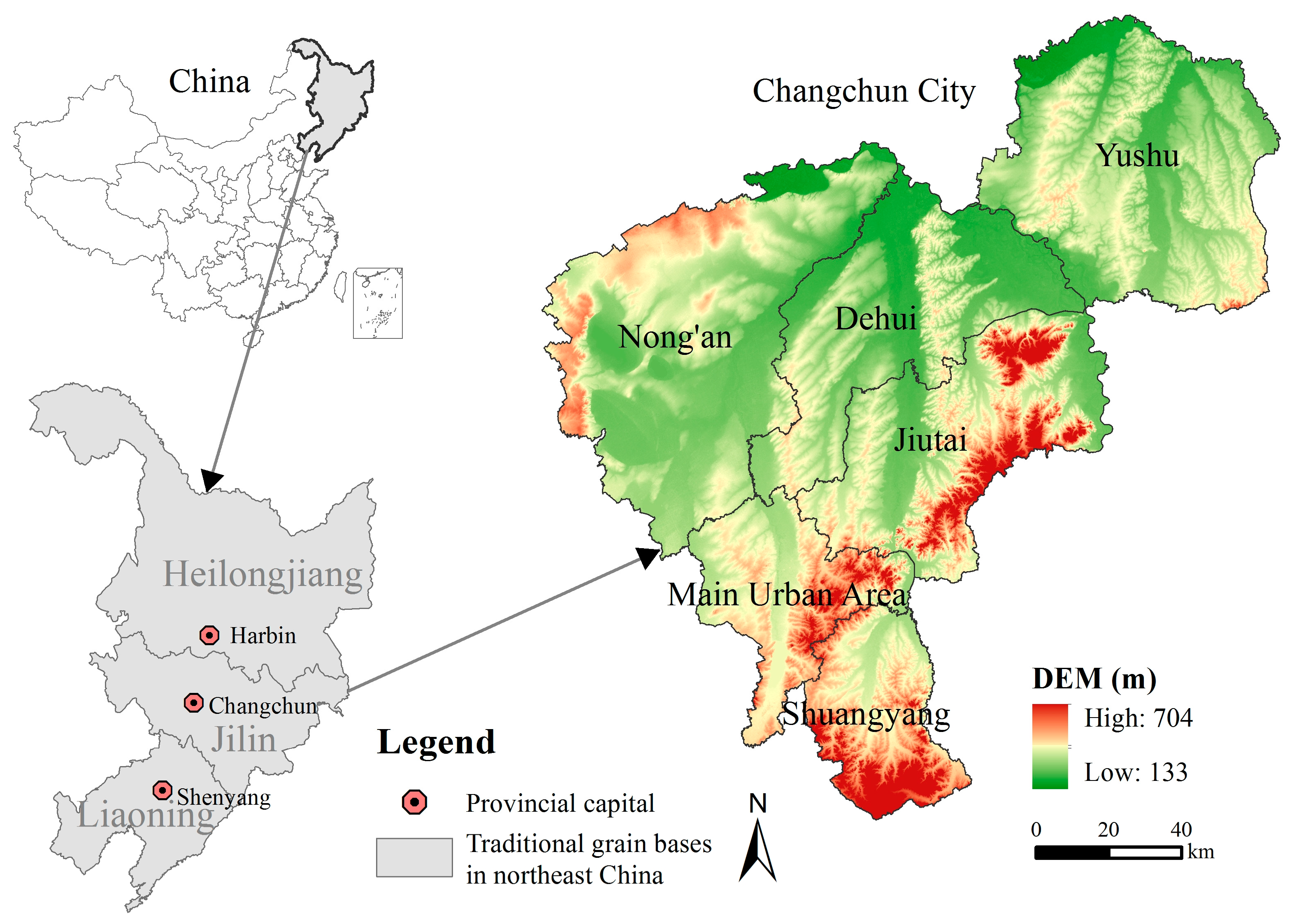
2.1. Study Area

Changchun city is the capital of Jilin Province and an economic center in Northeast China (Figure 1). Administratively, it is comprised of seven districts, two county-level units and one county, covering a total area of 20,595 km2. Changchun city lies in the hinterland of the Songliao plain, with an altitude between 250 and 350 m and is characterized by a continental monsoon climate. As one of the famous black soil regions in the world, the zonal soils are dark brown soil, black soil, and chernozem. Cropland accounts for more than 70% of the administrative area, whereas ecological land constitutes approximately 20% of the total area and is mainly distributed in the eastern forest region and the western farming-pastoral ecotone. However, the urbanization process and inappropriate land use has dramatically decreased the amount of ecological land and aggravated ecological risks in recent years. Due to the exhaustion of resources and the transformation of traditional heavy industry such as machinery, steel, and automobiles, the city has gradually acquired typical features of rust belt cities. Among them, the heavy metal soil contamination, land degradation, land abandonment, and other negative consequences further threaten the regional ecological security and agricultural production, hindering green development and urban renewal in this region.

2.2. Land Classification and Data Sources

Ecological land could provide considerable ecosystem services and plays an important role in maintaining regional ecological security. Although the concept was formally proposed in 1999, there is still no uniform definition and it is not included as a land use category in the “Current Land Use Classification” system, which is the predominant land use classification criteria for land regulation and management in China. Thus, we identified four ecological land use types by taking account of the definition of ecological land in this paper and the current land use classification system: forestland (F), grassland (G), water (W), and other ecological land (OEL, including saline—alkaline land, sandy land, bare land, and marshland). The remaining land was classified as cropland (C) and construction land (CL). More details are given a previous study that we conducted [30].
The land use data used in this study were derived from the National Land Survey database, in 2015, and were reclassified and integrated according to the classification criterion in this study. The soil type data were extracted from the Second National Soil Survey database. The digital elevation model (DEM) data were provided by the Computer Network Information Center of Chinese Academy of Sciences at a spatial resolution of 30 m (http://www.gscloud.cn). The normalized difference vegetation index (NDVI) data were obtained from the MOD13Q1 product of the United States Geological Survey (USGS) at a spatial resolution of 250 m (https://earthexplorer.usgs.gov). The unit size was 5 × 5 km2 for evaluating the ecological quality of cropland by referring to former studies and assessing the scope of the study area [34]. To keep the data units consistent, in view of the study area, the raster data were resampled to a 50 × 50 m2 cell size and the vector data were converted into raster data with an output cell size of 50 × 50 m2 [34].

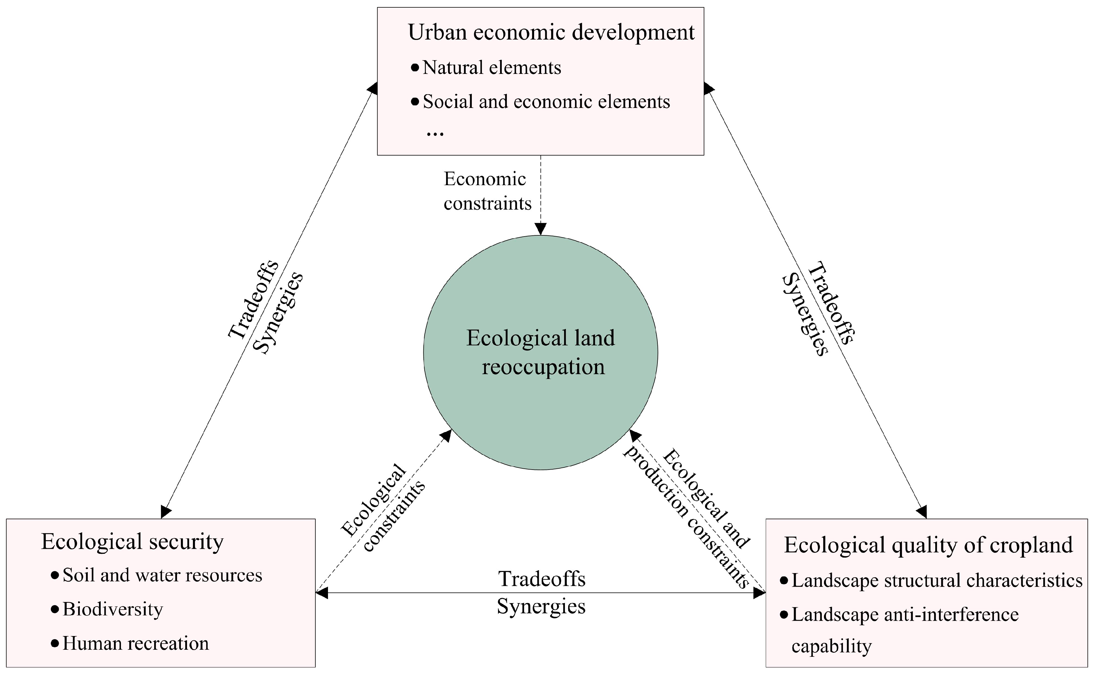
2.3. Theoretical Framework of Ecological Land Optimization

This section developed a theoretical framework for reoccupying ecological land in rust belt cities from the perspective of eco-economic trade-offs (Figure 2). Trade-offs refer to a situation in which some resources or features are lost while other resources or features are gained on account of different demands [35,36]. In recent years, trade-off analysis has been broadly applied in studies such as land use multifunctions, house selecting, and relationships between the rural production space and dwelling space [16,37,38]. Presently, social demands for ecological protection, food production, and residential environment have continuously intensified land use conflicts which hint at a mismatch between socio-economic and ecological systems. In this study, by identifying the trade-off relationships between the ecological requirements and the socio-economic targets, three aspects were determined to be the functional mappings of an “eco-economic” system, which were regional ecological security, urban economic development, and cropland ecological quality.
For one thing, ecological security could be considered to be a comprehensive reflection of various ecological processes in ecosystems, such as species movement, material circulation, and human recreation, implying both natural and cultural meanings [39]. It shows great significance in indicating regional ecological environmental health and guiding resources allocation [40]. Improving ecological security is one of the objectives of ecological land reoccupation, and could also be an appropriate measure to balance the economic development and ecological environmental protection. Therefore, this study takes regional ecological security as the ecological constraint for ecological land allocation. In addition, land resources are exploited and utilized for multiple goals, the most important of which is to satisfy the demands of economic development. Given the limited land resources, the shortage of construction land that can be used for production and dwellings is progressively increasing, and excessive urban expansion has become a crucial incentive for the encroachment of ecological land [41]. Urban economic development should be regarded as the economic constraint for reoccupying ecological land in the framework. In addition, as a crucial component of an eco-economic system, cropland embodies both production and ecological functions. In grain production areas, food security is undoubtedly the key issue for regional development, and it is first and foremost to strictly protect cropland in terms of quantity, quality, and ecology [30]. The ecological quality of cropland could be seen as an index to reflect the cropland landscape integrity and ecological suitability. Taking it as the spatial constraint of regional ecological land allocation would be helpful to make up for the lack of attention to cropland paid by the component of ecological security. Therefore, cropland ecological quality has been determined to be the eco-production constraint for ecological land reoccupation, and is as important as ecological security and urban economic development, and therefore further enriches and strengthens the framework of an eco-economic trade-off analysis.
In the framework, ecological security is mainly related to the capacity of ecosystem to satisfy human needs and maintain functional health and structural integrity, which could be assessed by simulating potential ecological processes in space [39,40]. According to the local conditions and the ecological conservation requirement, water and soil resources protection, biodiversity conservation, and human recreation security are chosen as the representative ecological processes to construct the ESP as the ecological constraint to ecological land reoccupation. In general, urban development is associated with multiple factors, which can be summarized as natural elements and socio-economic elements. For example, topographic conditions would directly affect the direction and intensity of urban expansion, and the growth of urban population leads to a corresponding increase in the demand for housing, transportation, and other service facilities [42,43]. In this study, the UDP was constructed by selecting relevant natural and socio-economic indexes and as the economic constraint for ecological land reoccupation. CEQ is the result of external disturbances and pressures acting on the cropland landscape, which could be represented through landscape structural characteristics and landscape anti-interference ability [44]. Therefore, a CEQ index was established to evaluate the ecological quality of cropland, thus as the third constraint in the framework (for the specific analysis process, see Supplementary Material S1).

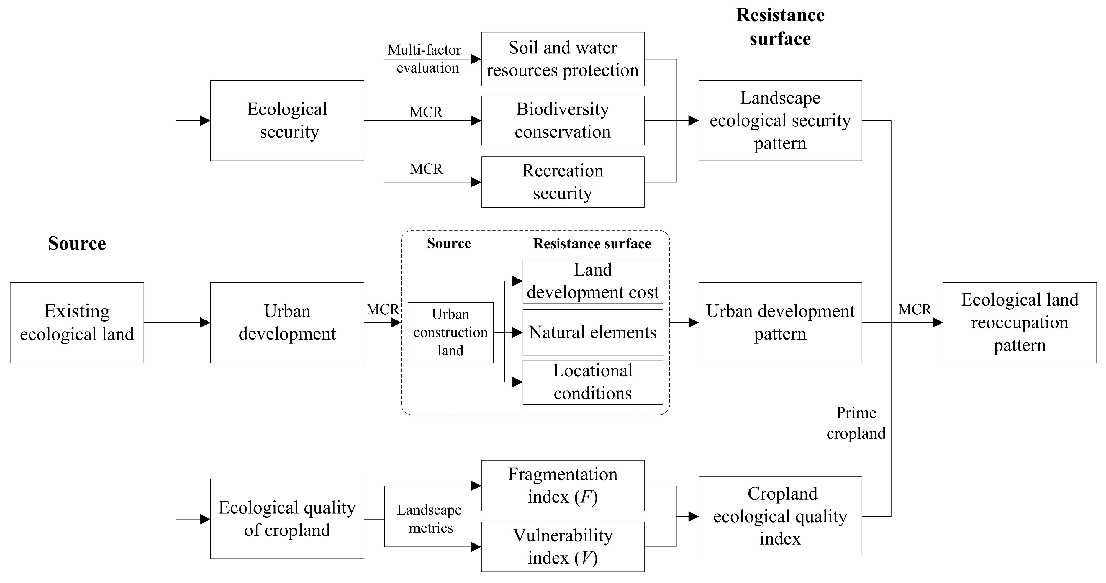
2.4. Analysis Methods and Process

2.4.1. Minimal Cumulative Resistance Model

On the basis of the trade-off analysis framework proposed in the manuscript, ecological security, urban development, and ecological quality of cropland can be seen as the spatial constraints for ecological land reoccupation. It is a feasible way to quantify the impact of constraints on ecological land by evaluating the suitability of overcoming multiple resistances and acquiring space, which can be achieved by the minimal cumulative resistance (MCR) model. The MCR refers to the resistance during the horizontal motion from a source to a destination in a heterogeneous space, which reflects the movement trends of matters. It was put forward by Knaapen, in 1992, and modified by Yu, in 1996, and has been proven to be applicable in landscape pattern simulation, land suitability assessment, and other research fields [45,46,47,48]. In this study, the MCR model was used to explore the suitable expansion direction of ecological land according to the calculation results of the minimal cumulative resistance value. The calculation process was performed using the “cost-distance” tool in the ArcGIS software (10.5, ESRI, Redlands, CA, USA). The formula is as follows:
M C R = f min j = n i = m ( D i j × R i )  
where MCR is the value of the minimal cumulative resistance, Dij is the spatial distance from source j to unit i, Ri is the resistance coefficient of unit i, and f is the function of the product of MCR and the variables.

2.4.2. Analysis Procedure

To clearly illustrate the analysis process, we presented an integrated and extensible optimization procedure, as shown in Figure 3, which basically included the following three steps: (1) determining the source, (2) building the resistance surfaces of the constraint elements, and (3) demarcating the spatial pattern for ecological land reoccupation. In this paper, the existing ecological land was selected as the extendable source. The single resistance surface could be specifically represented by the ecological security pattern, the urban development pattern, and the spatial distribution of cropland ecological quality index (for the specific analysis methods, see Supplementary Material S1).
To better understand the spatial distribution characteristics, we divided the simulation and assessment results of the ESP, UDP, and CEQ into four grades combining with a literature review and local conditions by using the Jenks natural breaks classification method, which arranges data into classes based on natural groups that can be realized in the ArcGIS software (Table 1) [44,49,50]. In order to indicate the level of ecological security from low to high, by consulting the local conditions and literature review, the ESP was classified into four regions, which were the core ecotope, the basic ecotope, the main ecotope, and the ideal ecotope [40,51]. Similarly, the UDP was divided into the suitable area, the buffer area, the restricted area, and the forbidden area to show the level of suitability of urban development and expansion by taking former studies as references [52]. The evaluation results of the CEQ were divided into four grades from Level I to Level IV considering the value ranges and previous experience, in which Level I indicated the highest ecological quality and Level IV indicated the lowest ecological quality [44]. The resistance coefficients of each grade were assigned to build the resistance surfaces after consulting former studies [50]. Conclusively, the comprehensive resistance surface was generated by overlaying the single resistance surfaces with equal weights and the ecological land reoccupation pattern was formulated by calculating the minimal cumulative resistance under scenarios involving different constrains. The results were divided into four levels to present the suitability of spatial expansion of ecological land, which were the suitable area, the preservation area, the configurable area, and the unsuitable area, by using the geometric interval integrated classification method in ArcGIS software [53,54].

3. Results

3.1. Spatial Distribution of the Constraint Elements

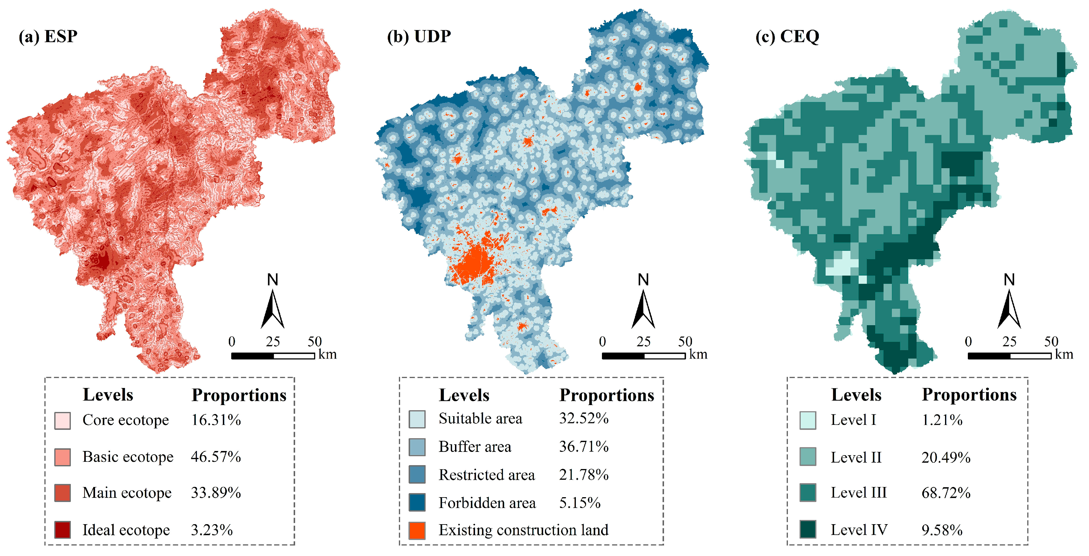
3.1.1. Ecological Security Pattern

By integrating single ecological processes, a comprehensive ecological security pattern was built and the core ecotope, the basic ecotope, the main ecotope, and the ideal ecotope, respectively accounted for 16.31%, 46.57%, 33.89%, and 3.23% of the total study area (Figure 4a). In terms of the spatial distribution, the core ecotope basically covered the main ecological sources and corridors with significant ecological value, and it formed an interconnected ecological network within the region, which created the key space for meeting the minimum ecological demands. The basic ecotope areas were mainly distributed around the core ecotope areas, and the land resources in these regions could satisfy the regional ecosystem service requirements together with the main ecotope, and the negative effects of external disturbances on the core ecotope could be mitigated, such as urban expansion. The ideal ecotope was the optimal situation of ecological land allocation, that is, the area was completely composed of ecological land, and the ecological benefits of land use would be maximized.

3.1.2. Urban Development Pattern

The suitability of urban development indicated a decreasing trend from the urban center to the urban fringe (Figure 4b). The grading results showed that the suitable development area accounted for 32.52% of the total study area, which was a relatively high proportion. In this case, if the constraints such as natural conservation and grain production were not taken into account, urban sprawl was very likely to occur. In the buffer area, restructuring industrial structure and allocating ecological land could be useful ways to achieve coordinated development between economic activities and ecological protection, and the land use efficiency would be accordingly enhanced. The restricted area and the forbidden area accounted for 21.78% and 5.15%, respectively. In these regions, production and construction activities should be strictly controlled and the land use structure needs to be optimized appropriately. Such measures would not only raise the ecological quality of land but also be an effective approach for restraining urban expansion.

3.1.3. Ecological Quality of Cropland

The CEQ evaluation results were divided into the following four grades: Level I (CEQ ≤ 0.61), Level II (0.61 < CEQ ≤ 0.75), Level III (0.75 < CEQ ≤ 0.9), and Level IV (CEQ > 0.9) (Figure 4c). The units in Level II and Level III accounted for 89% of the total units, which were widely distributed in typical traditional farming areas such as Dehui City, Yushu City, and Nong’an County. The concentrated cropland and large-scale agricultural production model in the farming area contributed to maintaining the ecological quality, displaying a relatively average and stable level of CEQ. The unit numbers in Level I were relatively low, accounting for approximately 1% of the total units. They were mainly distributed in the urban built-up area in the south and sporadically in the agro-pastoral ecotone in the west. In urban built-up areas, the land was mostly covered by impervious surfaces with little cropland, and the CEQ was barely affected in this region. The Level IV regions accounted for approximately 10% of the total units and were mostly gathered in the eastern forest area. Affected by the topography, reclamation, and other interference factors, the patches of cropland were increasingly fragmented, and this inevitably led to high ecological risks and a low level of CEQ.

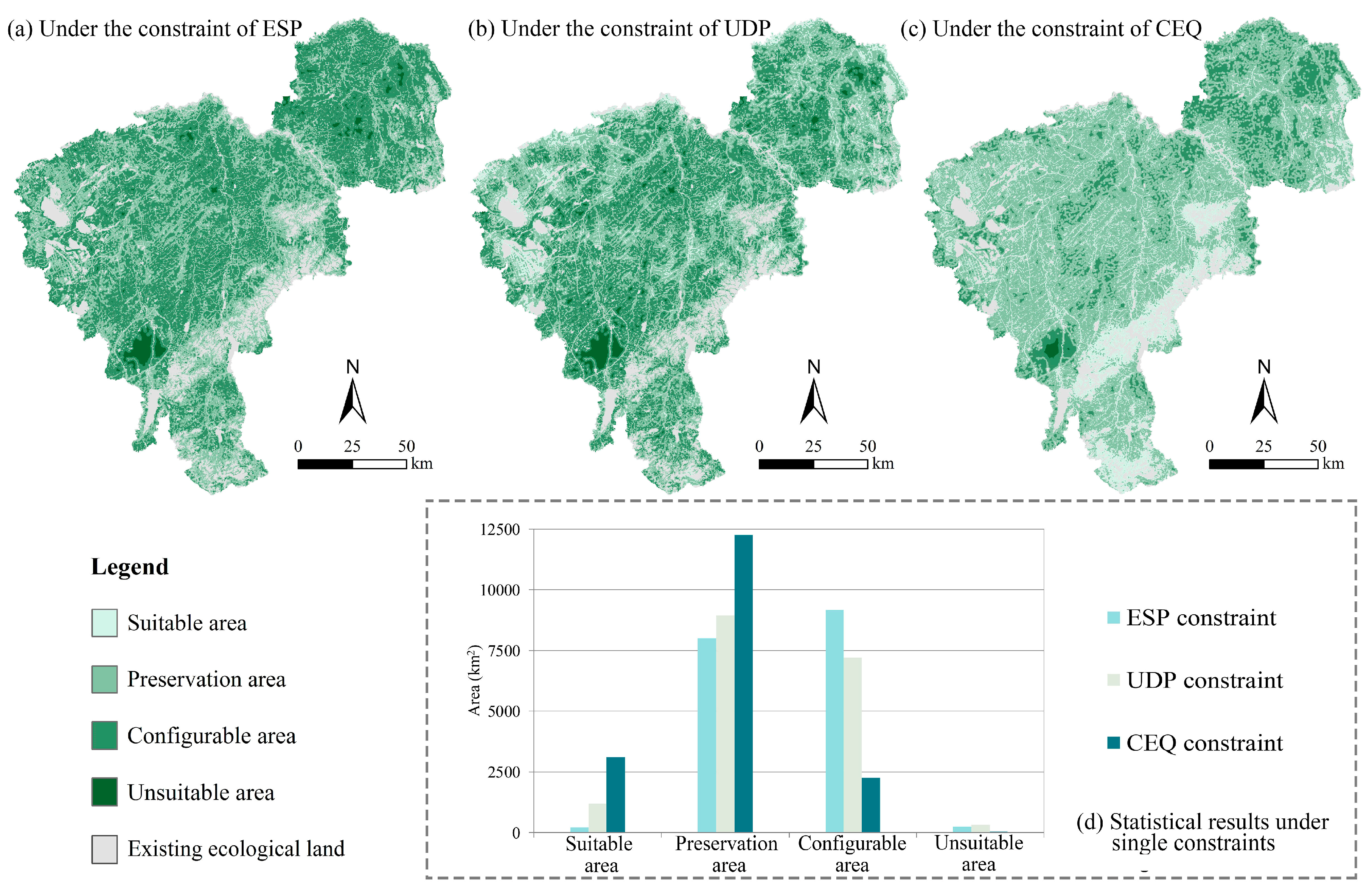
3.2. Simulation Results of Ecological Land Reoccupation Considering Single Constraints

Three scenarios of ecological land reoccupation under the single constraints of the ESP, UDP, and CEQ were individually simulated. The statistical results indicated that the preservation area and the configurable area for ecological land expansion consumed significant proportions in the three scenarios, whereas the proportions of suitable area and unsuitable area were relatively small (Figure 5d). Under the restriction of the ESP, the suitability of ecological land expansion showed a weakening trend from the existing ecological land to external land, which pointed out the appropriate spatial direction of the supplemented ecological land (Figure 5a). Combined with the ecological significance of the ecological security pattern, we speculated that by optimizing the ecological land that carried the key ecological processes, the fragmentation of the ecological land patches could be gradually reduced and the connectivity of ecological corridors could be strengthened to elevate the level of regional ecological security. Restricted by the UDP, the suitable expansion area and the preservation area were mainly distributed around the concentrated ecological land in the western and eastern regions, whereas the unsuitable area was concentrated in the main urban region (Figure 5b). Influenced by the intensive socio-economic activities, the resistance value of the ecological land expansion within the urban built-up areas was relatively large, which made it difficult to convert construction land to ecological land. The simulation process considering the constraint of UDP not only evaluated the suitability of ecological land expansion but also indicated the geospatial trade-off between ecological protection and economic development. The results would be beneficial to realize the bidirectional optimization of construction land and ecological land, especially in the conflict-ridden peri-urban areas. Under the constraint of the CEQ, the preservation area took the largest proportion and was widely distributed in the farming region (Figure 5c). The suitable area mainly covered the forest region in the east, where it also faced high ecological risks and environmental issues and could further decrease the ecological quality of cropland and threaten the high-quality cropland in surrounding areas. To relieve the ecological pressure on cropland, measures such as agricultural structural adjustment and ecological fertile cropland construction should be implemented to promote the cropland ecosystem and the development of multifunctional agriculture.

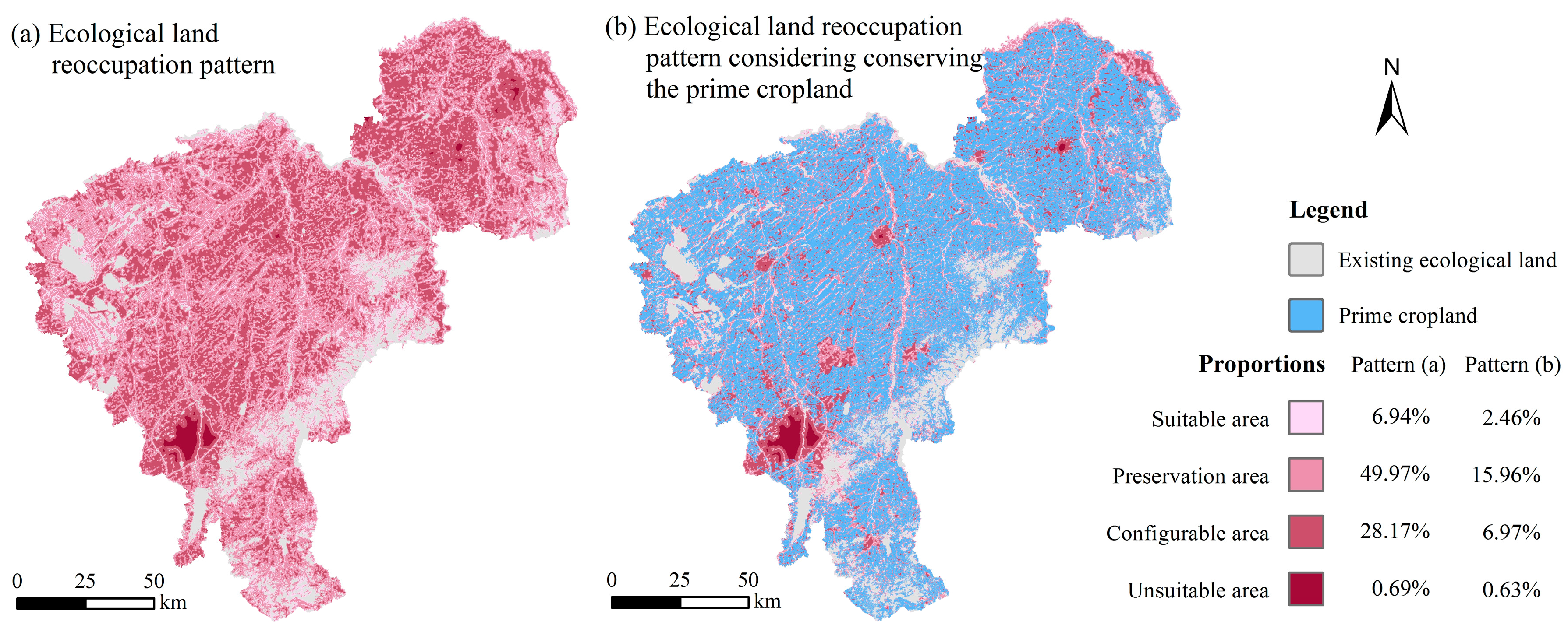
3.3. Comprehensive Simulation Results of Ecological Land Reoccupation Considering Multiple Constraints

Ultimately, we constructed a comprehensive ecological land reoccupation pattern by considering the overall constraints of the ESP, UDP, and CEQ (Figure 6a). The results showed the proportions of the suitable area, the preservation area, the configurable area, and the unsuitable area were respectively 6.94%, 49.97%, 28.17%, and 0.69%. The suitable area was distributed in the west of the study area, where widespread overgrazing, soil degradation, and salinization have aggravated the vulnerability of the regional ecological environment and made it a famous ecologically fragile region in Jilin Province. In view of this, ecological restoration projects using engineering techniques should receive more attention to reverse the trend of environmental deterioration as soon as possible. In the typical farming regions of the central and northeastern parts of the study area, the suitable area for ecological land reoccupation were mainly scattered or distributed in bands around the existing ecological land. In this region, building sheltering forest belts could be an appropriate method to increase the amount of ecological land, regulate the microclimate, and prevent wind erosion, which are beneficial for improving the ecological performance of agricultural land use. Within the urban region, the violent expansion of construction land has remarkably damaged the natural landscape, especially in the peri-urban area, and brought such problems including soil pollution, land abandonment, and cropland fragmentation. The closely connected distribution pattern between construction land and cropland could be a potential threat to cropland quality. In this case, delimiting urban growth boundaries, reclaiming abandoned industrial land, and establishing ecological belts according to the simulation results could reduce the conflicts between urban development and cropland protection, and promote the intensive utilization of construction land. In addition, the prime cropland preservation area (delimited by the land management department to strictly maintain the amount of cropland) was overlaid on the ecological land reoccupation pattern as another restriction to food security in traditional grain bases (Figure 6b). As a result, the proportions of the suitable area, the preservation area, the configurable area, and the unsuitable area experienced a distinct decline and decreased to 2.46%, 15.96%, 6.97%, and 0.63%, respectively, which greatly compressed the expandable space of ecological land.

4. Discussion

4.1. Ecological Land Optimization Mode of Rust Belt Cities in Farming Areas

It seems that the negative effects caused by social development and industrial transformation were inescapable in the post industrialization period. However, the problems, which embody the inexorable law of urban development, still remain unresolved across the world [55,56]. Remarkable land conversions have been observed in the rapid urbanization process, such as an expanded amount of construction land, a decreased amount of ecological land, and fragmented cropland, posing an urgent situation for land resource allocation. According to the simulation results, the suitable expansion area for ecological land mainly expands outwardly from the existing ecological land. In other words, it is a viable option to form a concentrated ecological land use mode with good connectivity and integrated corridors to advance regional ecological security. Quantitatively, the space that is suitable to be reoccupied and converted to ecological land is relatively ample, which provides favorable conditions for urban ecological planning and urban renewal. Given the national strategic role of the traditional grain base, the demands for grain production in this region should not be ignored. Therefore, it is also necessary to set sufficient space for high-quality prime cropland and outside room to prevent this region from experiencing excessive human interference.
Unlike other typical rust belt cities, the population urbanization rate in Changchun city is still growing rapidly, meaning that farmers are more willing to move to the urban region to engage in the service industry and other businesses. It could be explained from a certain point of view that the economic benefits of agricultural production or the planting industry are not attractive enough to farmers and other stakeholders, and this may lead to the problems such as vacant villages and abandoned cropland. To turn the situation around, some local governments have taken a series of actions such as investing in high-tech industries and developing multifunctional and modernized agriculture, demonstrating a commitment to change the face of their city [27,57,58]. For example, the investment and redevelopment in cultural events and sports was the first step in the transformation in Hamilton and it has shown remarkable evidence of urban improvement [58]. However, in the long run, it might be more essential to rationally allocate ecological resources to build a green, efficient, and sustainable city, which could also be an opportunity for postindustrial cities to achieve revitalization.

4.2. Managerial Implications

As a result of industrial decline and outflow of population, Northeast China, epitomized by Changchun city, has experienced continuous economic downturns for a long time. The “Revitalizing the Old Industrial Base of Northeast China” policy proposed in 2003 aimed to revive the economy in Northeast China. However, large areas of ecological land were also removed due to the remarkable urban expansion. In addition to urbanization and industrialization, the loss of ecological resources has also been linked to agricultural encroachment [57,59]. Since the 1990s, China has enacted a series of measures such as agricultural tax relief to boost grain production and cropland protection, which also have led to massive illegal cultivation. The unreasonable farming practices and policy-driven conversions of dry land to paddy land have further resulted in uneven distributions of water and soil resources, and the degradation of wetlands and grasslands. As reported by Mao, 60% of China’s lost natural wetland resources have been due to agricultural reclamation [60]. It has been suggested that excessive agricultural protection could trigger a chain reaction in the ecological environment [61].
In response to the above problems, China has put forward diverse ecological protection policies since the 1980s. Studies have showed that good policies and a reasonable ecological land structure could sufficiently improve the environment. For example, Hu analyzed the relationships between the NDVI and economic growth in the Pearl River Delta region, over the past 20 years, and believed that afforestation and good economic policies could be helpful to achieve rapid economic development and improved vegetation coverage, simultaneously [62]. Obviously, for the rust belt cities in traditional grain bases, the urban land abandonment and inefficient use of cropland provide available room for the reoccupation of ecological resources. Therefore, more synthetic and forward-looking measures should be taken to promote the coordinated development between land use and eco-economic system and improve regional land management.
First, we should pay more attention to the utilization of ecological resources. Currently, regional ecosystem services are still declining despite the implementation of policies that have reversed the massive loss of natural resources to some extent, such as the increased forestland identified in recent years [63]. However, the utilization quality of ecological resources still needs to be further strengthened. For rust belt cities, the reclamation of abandoned industrial and mining lands could be beneficial to optimize the land use patterns, urban landscape, and living conditions, but the effectiveness of such ecological conservation projects has yet to be measured. Second, the overemphasis on food production should be reduced. Although food security needs to be fully guaranteed, it seems that agricultural production is in a state of being overprotected and serious impacts on the degradation of natural ecological resources have been detected [30,61]. With technological advancements and slowing population growth, grain output yield per unit area has been greatly increased, which has been able to meet the needs of society. It is not feasible to keep reclaiming low-quality cropland and occupying ecological resources with the strict quantity requirements of cropland protection as the only reason, and the utilization mode of cropland should be gradually greened and modernized to reduce the impacts on the natural ecosystem. Third, urban expansion should be scientifically and smartly controlled. Rust belt cities are now facing problems of low utilization efficiency and an unreasonable internal structure of their land use. Unlike other rust belt cities that are shrinking, the rate of land urbanization in this study area has been kept at a high level, which means that the urban sprawl has not been completely contained [64]. Thus, it would be necessary to focus on the enhancement of the urban development quality from a long-term perspective. Moreover, equal consideration should be given to the intensive use of construction land, the allocation of the green space within the city, and the ecological protection of the surrounding cropland. This is an urgent affair for urban green development and an inexorable trend for global sustainable development.

5. Conclusions

This paper proposed a conceptual framework for reoccupying the ecological land from the perspective of eco-economic trade-offs in a rust belt city in Northeast China. We quantified the influencing factors of the eco-economic system for the allocation of ecological land and simulated the distribution of ecological land reoccupation in a geographic space. The ecological land reoccupation pattern under the restrictions of the ESP, the UDP, and the CEQ showed similar characteristics in the quantity distribution while the difference in the spatial distribution was distinct. The simulation results under the co-constraints indicated that the suitable area for ecological land reoccupation was mainly distributed around the existing ecological sources and the unsuitable area basically covered the built-up region, which represented the spatial trade-offs between ecological protection and economic development. However, under the strict cropland protection policies such as the prime cropland preservation, the space for ecological land reoccupation was intensively compressed and divided. Thus, it is also a crucial issue for this region to consider whether the agricultural protection policies should be reevaluated and reformulated.
The results of this study implied that reasonable measures and policies, such as the construction of an ecological corridor, ecological restoration, and the demarcation of urban development boundaries, could be possible ways to optimize regional ecological land, which was also of great significance for the urban revitalization and sustainable development in rust belt cities; and the results could also provide references for regional land use planning and ecological resource management. It is worth noting that there still exist a lot of conflicts during the implementation of ecological conservation strategies, urban development planning, and cropland protection policies, ranging from the central government to the local government, which create obstacles for resource management. Therefore, better integration of interdepartmental planning and policies is needed to satisfy the interests of the different stakeholders.

Supplementary Materials

The following are available online at https://www.mdpi.com/2073-445X/9/9/297/s1, Supplementary material S1: Specific methods used in the construction of resistance surfaces.

Author Contributions

Conceptualization, S.L. and D.W.; methodology, S.L. and W.L.; software, S.L.; validation, H.L. and G.L.; formal analysis, S.L. and W.L.; investigation, H.L. and J.G.; resources, D.W.; data curation, D.W. and H.L.; writing—original draft preparation, S.L.; writing—review and editing, D.W. and H.L.; visualization, S.L.; supervision, G.L.; project administration, S.L.; funding acquisition, S.L. and J.G. All authors have read and agreed to the published version of the manuscript.

Funding

This research was funded by the Philosophy and Social Science Project of Shenyang, China (grant number 18052Q), the Fundamental Research Funds for the Central University (grant number N181403004, N171403002), the Postdoctoral Fund of Northeastern University (grant number 20190322), and the Ministry of Education Humanities and Social Sciences Foundation Youth Project of China (grant number 19YJC630037).

Acknowledgments

The authors would like to acknowledge the valuable comments and recommendations made by the reviewers.

Conflicts of Interest

The authors declare no conflict of interest.

References

  1. Bai, X.M.; Chen, J.; Shi, P.J. Landscape urbanization and economic growth in China: Positive feedbacks and sustainability dilemmas. Environ. Sci. Technol. 2012, 46, 132–139. [Google Scholar] [PubMed]
  2. Cai, Z.Y.; Liu, Q.; Cao, S.X. Real estate supports rapid development of China’s urbanization. Land Use Policy 2020, 95, 104582. [Google Scholar] [CrossRef]
  3. Martin, D.J.; Chen, Y.W.; Simon, J.; Lu, H.Y.; Zhao, M.X.; Yang, Q.H.; Zhang, C.N. Explaining city branding practices in China’s three mega-city regions: The role of ecological modernization. J. Clean. Prod. 2018, 179, 527–543. [Google Scholar]
  4. Lambin, E.F.; Meyfroidt, P. Global land use change, economic globalization, and the looming land scarcity. Proc. Natl. Acad. Sci. USA 2011, 108, 3465–3472. [Google Scholar] [CrossRef] [Green Version]
  5. Song, W.; Bryan, C.P.; Amin, T. Urban expansion and its consumption of high-quality farmland in Beijing, China. Ecol. Indic. 2015, 54, 60–70. [Google Scholar] [CrossRef]
  6. Wang, J.L.; Zhou, W.Q.; Steward, T.A.P.; Yu, W.J.; Li, W.F. A multiscale analysis of urbanization effects on ecosystem services supply in an urban megaregion. Sci. Total Environ. 2019, 662, 824–833. [Google Scholar] [CrossRef]
  7. He, B.J.; Zhao, Z.Q.; Shen, L.D.; Wang, H.B.; Li, L.G. An approach to examining performances of cool/hot sources in mitigating/enhancing land surface temperature under different temperature backgrounds based on Landsat 8 image. Sustain. Cities Soc. 2018, 44, 416–427. [Google Scholar] [CrossRef]
  8. National Bureau of Statistics of China. Statistical Communiqué of the People’s Republic of China on the 2019 National Economic and Social Development; The National Bureau of Statistics of China: Beijing, China, 2020. (in Chinese) [Google Scholar]
  9. Chen, J. Rapid urbanization in China: A real challenge to soil protection and food security. Catena 2007, 69, 1–15. [Google Scholar] [CrossRef]
  10. Danish; Ulucak, R.; Khan, S.U.D. Determinants of the ecological footprint: Role of renewable energy, natural resources, and urbanization. Sustain. Cities Soc. 2020, 54, 101996. [Google Scholar] [CrossRef]
  11. Kuusaana, E.D.; Eledi, J.A. Customary land allocation, urbanization and land use planning in Ghana: Implications for food systems in the Wa Municipality. Land Use Policy 2015, 48, 454–466. [Google Scholar] [CrossRef]
  12. Guo, X.D.; Chang, Q.; Liu, X.; Bao, H.M.; Zhang, Y.P.; Tu, X.Y.; Zhu, C.X.; Lv, C.Y.; Zhang, Y.Y. Multi-dimensional eco-land classification and management for implementing the ecological redline policy in China. Land Use Policy 2018, 74, 15–31. [Google Scholar] [CrossRef]
  13. Zhang, Y.Z.; Hu, Y.F.; Zhuang, D.F. A highly integrated, expansible, and comprehensive analytical framework for urban ecological land: A case study in Guangzhou, China. J. Clean. Prod. 2020, 268, 122360. [Google Scholar] [CrossRef]
  14. Colding, J. ‘Ecological land-use complementation’ for building resilience in urban ecosystems. Landsc. Urban Plan. 2007, 81, 46–55. [Google Scholar] [CrossRef]
  15. Nguyen, K.A.; Liou, Y.A. Global mapping of eco-environmental vulnerability from human and nature disturbances. Sci. Total Environ. 2019, 664, 995–1004. [Google Scholar] [CrossRef]
  16. Zhang, Y.N.; Long, H.L.; Tu, S.S. Spatial identification of land use functions and their tradeoffs/synergies in China: Implications for sustainable land management. Ecol. Indic. 2019, 107, 105550. [Google Scholar] [CrossRef]
  17. Tan, Y.Z.; Zhao, Y.; Cao, Y.; He, J. Research Progress on Regional Ecological Land Classification in China. China Land Sci. 2016, 30, 28–36. (In Chinese) [Google Scholar]
  18. Zhou, R.; Wang, X.J.; Su, H.L.; Lou, Y.L. Identification and security pattern of ecological land in Pingdingshan newly developed area. Acta Ecol. Sin. 2015, 35, 2003–2012. (In Chinese) [Google Scholar]
  19. Wu, A.B.; Zhao, Y.X. Analysis of ecological land pattern evolution and ecosystem service value in Bashang plateau. Trans. Chin. Soc. Agric. Eng. 2017, 33, 283–290. (In Chinese) [Google Scholar]
  20. Ekkel, E.D.; De, V.S. Nearby green space and human health: Evaluating accessibility metrics. Landsc. Urban Plan. 2017, 157, 214–220. [Google Scholar] [CrossRef]
  21. Hasala, D.; Supak, S.; Rivers, L. Green infrastructure site selection in the Walnut Creek wetland community: A case study from southeast Raleigh, North Carolina. Landsc. Urban Plan. 2020, 196, 103743. [Google Scholar] [CrossRef]
  22. Afriyanie, D.; Julian, M.M.; Riqqi, A.; Akbar, R.; Djoko, S.A.S.; Kustiwan, I. Re-framing urban green spaces planning for flood protection through socio-ecological resilience in Bandung City, Indonesia. Cities 2020, 101, 102710. [Google Scholar] [CrossRef]
  23. Bertram, C.; Rehdanz, K. The role of urban green space for human well-being. Ecol. Econ. 2015, 120, 139–152. [Google Scholar] [CrossRef] [Green Version]
  24. Sharifi, E.; Larbi, M.; Omrany, H.; Boland, J. Climate change adaptation and carbon emissions in green urban spaces: Case study of Adelaide. J. Clean. Prod. 2020, 254, 120035. [Google Scholar] [CrossRef]
  25. Jiang, B.; Bai, Y.; Wong, C.P.; Xu, X.B.; Alatalo, J.M. China’s ecological civilization program-Implementing ecological redline policy. Land Use Policy 2019, 81, 111–114. [Google Scholar] [CrossRef]
  26. Gao, J.; Zou, C.; Zhang, K.; Xu, M.J.; Wang, Y. The establishment of Chinese ecological conservation redline and insights into improving international protected areas. J. Environ. Manag. 2020, 264, 110505. [Google Scholar] [CrossRef]
  27. Deng, X.Z.; Huang, J.K.; Rozelle, S.; Uchida, E. Cultivated land conversion and potential agricultural productivity in China. Land Use Policy 2006, 23, 372–384. [Google Scholar] [CrossRef]
  28. Xie, L.; Yang, Z.S.; Cai, J.M.; Cheng, Z.; Wen, T.; Song, T. Harbin: A rust belt city revival from its strategic position. Cities 2016, 58, 26–38. [Google Scholar] [CrossRef]
  29. Pei, P.; Fan, Y. Study on Revitalizing Northeast China through a new road of industrialization. Can. Soc. Sci. 2008, 4, 74–80. [Google Scholar]
  30. Liu, S.H.; Wang, D.Y.; Lei, G.P.; Li, H.; Li, W.B. Elevated risk of ecological land and underlying factors associated with rapid urbanization and overprotected agriculture in northeast China. Sustainability 2019, 11, 6203. [Google Scholar] [CrossRef] [Green Version]
  31. Li, W.B.; Wang, D.Y.; Li, H.; Wang, J.G.; Zhu, Y.L.; Yang, Y.W. Quantifying the spatial arrangement of underutilized land in a rapidly urbanized rust belt city: The case of Changchun City. Land Use Policy 2019, 83, 113–123. [Google Scholar] [CrossRef]
  32. Mao, D.H.; He, X.Y.; Wang, Z.M.; Tian, Y.L.; Xiang, H.X.; Yu, H.; Man, W.D.; Jia, M.M.; Ren, C.Y.; Zheng, H.F. Diverse policies leading to contrasting impacts on land cover and ecosystem services in Northeast China. J. Clean. Prod. 2019, 240, 117961. [Google Scholar] [CrossRef]
  33. Liu, L.; Liu, Z.J.; Gong, J.Z.; Wang, L.; Hu, Y.M. Quantifying the amount, heterogeneity, and pattern of farmland: Implications for China’s requisition-compensation balance of farmland policy. Land Use Policy 2019, 81, 256–266. [Google Scholar] [CrossRef]
  34. Zhou, H.; Lei, G.P.; Yang, X.X. Land Use Change Pattern and Its Spatial Differentiation in Typical Basin of Sanjiang Plain. Trans. Chin. Soc. Agric. Mach. 2017, 48, 142–151. (In Chinese) [Google Scholar]
  35. Thomas, H. Decisions with multiple objectives: Preferences and value trade-offs. J. Oper. Res. Soc. 1977, 28, 602–603. [Google Scholar]
  36. Rodrígue, J.P.; Douglas, B.T.; Bennett, E.M.; Cumming, G.S. Trade-offs across space, time, and ecosystem services. Ecol. Soc. 2005, 11, 709–723. [Google Scholar]
  37. Zhang, B.L.; Jiang, G.H.; Qu, Y.B. Trade-off of productive and dwelling space of rural settlement in developed areas. Trans. Chin. Soc. Agric. Eng. 2019, 35, 253–261. (In Chinese) [Google Scholar]
  38. Zhang, S.Y.; Shi, Z.Q.; Song, X.Q.; Deng, W. Space trade-offs analysis in the urban floating population residential self-selection: A case study of Chengdu. Geogr. Res. 2018, 37, 2554–2566. [Google Scholar]
  39. Fu, Y.J.; Shi, X.Y.; He, J.; Yuan, Y.; Qu, L.L. Identification and optimization strategy of county ecological security pattern: A case study in the Loess Plateau, China. Ecol. Indic. 2020, 112, 106030. [Google Scholar] [CrossRef]
  40. Wang, R.H.; Li, X.Y.; Zhang, S.W.; Li, Y.B.; Cao, C. Research for landscape ecological security pattern and early warning in farming-pastoral zone of northeast China: A case study of Tongyu County in Jilin Province. Geogr. Geo-Inf. Sci. 2014, 30, 111–115. (In Chinese) [Google Scholar]
  41. Mao, D.H.; Wang, Z.M.; Wu, J.G.; Wu, B.F.; Zeng, Y.; Song, K.S.; Yi, K.P.; Luo, L. China’s wetlands loss to urban expansion. Land Degrad. Dev. 2018, 29, 2644–2657. [Google Scholar] [CrossRef]
  42. Azhdari, A.; Sasani, M.A.; Soltani, A. Exploring the relationship between spatial driving forces of urban expansion and socioeconomic segregation: The case of Shiraz. Habitat Int. 2018, 81, 33–44. [Google Scholar] [CrossRef]
  43. Luo, J.J.; Zhang, X.L.; Wu, Y.Z.; Shen, J.H.; Shen, L.Y.; Xing, X.S. Urban land expansion and the floating population in China: For production or for living? Cities 2017, 74, 219–228. [Google Scholar] [CrossRef]
  44. Pei, H.; Wei, Y.; Wang, X.; Qin, Z.; Hou, C. Method of cultivated land landscape ecological security evaluation and its application. Trans. Chin. Soc. Agric. Eng. 2014, 30, 212–219. (In Chinese) [Google Scholar]
  45. Knaapen, J.P.; Scheffer, M.; Harms, B. Estimating habitat isolation in landscape planning. Landsc. Urban Plan. 1992, 23, 1–16. [Google Scholar] [CrossRef]
  46. Yu, K.J. Security patterns and surface model in landscape ecological planning. Landsc. Urban Plan. 1996, 36, 1–17. [Google Scholar] [CrossRef]
  47. Pan, J.H.; Liu, X. Assessment of landscape ecological security and optimization of landscape pattern based on spatial principal component analysis and resistance model in arid inland area: A case study of Ganzhou District, Zhangye City, Northwest China. Chin. J. Appl. Ecol. 2015, 26, 3126–3136. (In Chinese) [Google Scholar]
  48. Liu, X.F.; Shu, J.M.; Zhang, L.B. Research on applying minimal cumulative resistance model in urban land ecological suitability assessment: As an example of Xiamen City. Acta Ecol. Sin. 2010, 30, 421–428. (In Chinese) [Google Scholar]
  49. Jenks, G.F. The data model concept in statistical mapping. Int. Yearb. Cartogr. 1967, 7, 186–190. [Google Scholar]
  50. Liu, S.H.; Wang, D.Y.; Li, H.; Li, W.B.; Zhu, Y.L.; Wu, W.J. The Ecological Security Pattern and Its Constraint on Urban Expansion of a Black Soil Farming Area in Northeast China. ISPRS Int. J. Geo-Inf. 2017, 6, 263. [Google Scholar]
  51. Huang, M.Y.; Yue, W.Z.; Feng, S.R.; Cai, J.J. Analysis of spatial heterogeneity of ecological security based on MCR model and ecological pattern optimization in the Yuexi county of the Dabie Mountain Area. J. Nat. Resour. 2019, 34, 771–784. (In Chinese) [Google Scholar]
  52. Wang, S.Y.; Ou, M.H. Zoning for regulating of construction land based on landscape security pattern. Acta Ecol. Sin. 2013, 33, 4425–4435. (In Chinese) [Google Scholar]
  53. Meng, J.J.; Wang, Y.; Wang, X.D.; Zhou, Z.; Sun, N. Construction of landscape ecological security pattern in Guiyang based on MCR model. Resour. Environ. Yangtze Basin 2016, 25, 1052–1061. (In Chinese) [Google Scholar]
  54. Su, Y.X.; Zhang, H.O.; Chen, X.Z.; Huang, G.Q.; Ye, Y.Y.; Wu, Q.T.; Huang, N.S.; Kuang, Y.Q. The ecological security patterns and construction land expansion simulation in Gaoming. Acta Ecol. Sin. 2013, 33, 1524–1534. (In Chinese) [Google Scholar]
  55. Marciniak, R.W.; Sikorska, D.; Krauze, K. Residents’ awareness of the role of informal green spaces in a post-industrial city, with a focus on regulating services and urban adaptation potential. Sustain. Cities Soc. 2020, 59, 102236. [Google Scholar] [CrossRef]
  56. Draus, P.; Roddy, J.; Mcduffie, A. “It’s about half and half”: Austerity, possibility and daily life inside a depopulated Detroit neighborhood. City Cult. Soc. 2018, 14, 37–46. [Google Scholar] [CrossRef]
  57. Hu, X.H.; Yang, C. Building a role model for rust belt cities? Fuxin’s economic revitalization in question. Cities 2017, 72, 245–251. [Google Scholar] [CrossRef]
  58. Jakar, G.S.; Dunn, J.R. (Turning Rust into Gold?) Hamilton, Ontario and a Canadian perspective of shrinking and declining cities. Cities 2019, 94, 1–10. [Google Scholar] [CrossRef]
  59. Guo, Y.H.; Tong, L.J.; Mei, L. The effect of industrial agglomeration on green development efficiency in Northeast China since the revitalization. J. Clean. Prod. 2020, 258, 120584. [Google Scholar] [CrossRef]
  60. Mao, D.H.; Luo, L.; Wang, Z.M.; Wilson, M.C.; Zeng, Y.; Wu, B.F.; Wu, J.G. Conversions between natural wetlands and farmland in China: A multiscale geospatial analysis. Sci. Total Environ. 2018, 634, 550–560. [Google Scholar] [CrossRef]
  61. Liu, T.; Liu, H.; Qi, Y.J. Construction land expansion and cultivated land protection in urbanizing China: Insights from national land surveys, 1996–2006. Habitat Int. 2015, 46, 13–22. [Google Scholar] [CrossRef]
  62. Hu, M.M.; Xia, B.C. A significant increase in the normalized difference vegetation index (NDVI) during the rapid economic development in the Pearl River Delta of China. Land Degrad. Dev. 2018, 30, 359–370. [Google Scholar]
  63. Wang, Y.H.; Brandt, M.; Zhao, M.F.; Xing, K.X.; Wang, L.H.; Tong, X.W.; Xue, F.; Kang, M.Y.; Jiang, Y.; Fensholt, R. Do afforestation projects increase core forests? Evidence from the Chinese Loess Plateau. Ecol. Indic. 2020, 117, 106558. [Google Scholar] [CrossRef]
  64. Li, F.; Tian, C.H. Construction land quotas as a tool for managing urban expansion. Landsc. Urban Plan. 2020, 195, 103727. [Google Scholar]
Figure 1. Overview map of the study area.
Land 09 00297 g001
Figure 2. Theoretical framework of the ecological land optimization trade-offs.
Land 09 00297 g002
Figure 3. Analysis procedure and methods.
Land 09 00297 g003
Figure 4. The classification results of (a) Ecological security pattern (ESP); (b) Urban development pattern (UDP); and (c) Cropland ecological quality (CEQ).
Land 09 00297 g004
Figure 5. Ecological land reoccupation pattern under the single constraints of (a) the ESP; (b) the UDP; (c) the CEQ; and (d) the statistical results.
Land 09 00297 g005
Figure 6. Ecological land reoccupation pattern. (a) Based on multiple constraints; (b) Considering conserving the prime cropland.
Land 09 00297 g006
Table 1. Single resistance surface classification and resistance coefficients.
ConstraintsResistance SurfaceClassificationDescriptionsResistance Coefficients
Ecological securityEcological security patternCore ecotopeThe core ecotope is the crucial area that guarantees the key ecological process, and construction activities should be strictly prohibited in this region. The basic ecotope and the main ecotope could meet most ecosystem service requirements with great potential for improvement. The ideal ecotope refers to the area that can maximize the ecological benefits of land use, which is an optimal situation.10
Basic ecotope20
Main ecotope50
Ideal ecotope100
Urban developmentUrban development patternSuitable areaThe urban development pattern could represent the suitability of economic activities. Considering the perspective of ecological priority, the forbidden area is the bottom line for ecological land protection. The suitable area, the buffer area and the restricted area can be developed according to their resistance values from small to large.100
Buffer area50
Restricted area20
Forbidden area10
Ecological quality of croplandLevels of cropland ecological qualityLevel IThe higher the level of CEQ is, the better the ability of cropland to withstand external interferences. Optimizing the quantity and structure of the ecological land in low ecological quality areas would enhance the ecosystem service function of cropland and mitigate the risks.100
Level II50
Level III20
Level IV10

