Exploring Forest Change Spatial Patterns in Papua New Guinea: A Pilot Study in the Bumbu River Basin

 ,
, 


Abstract
:
1. Introduction
2. Materials and Methods
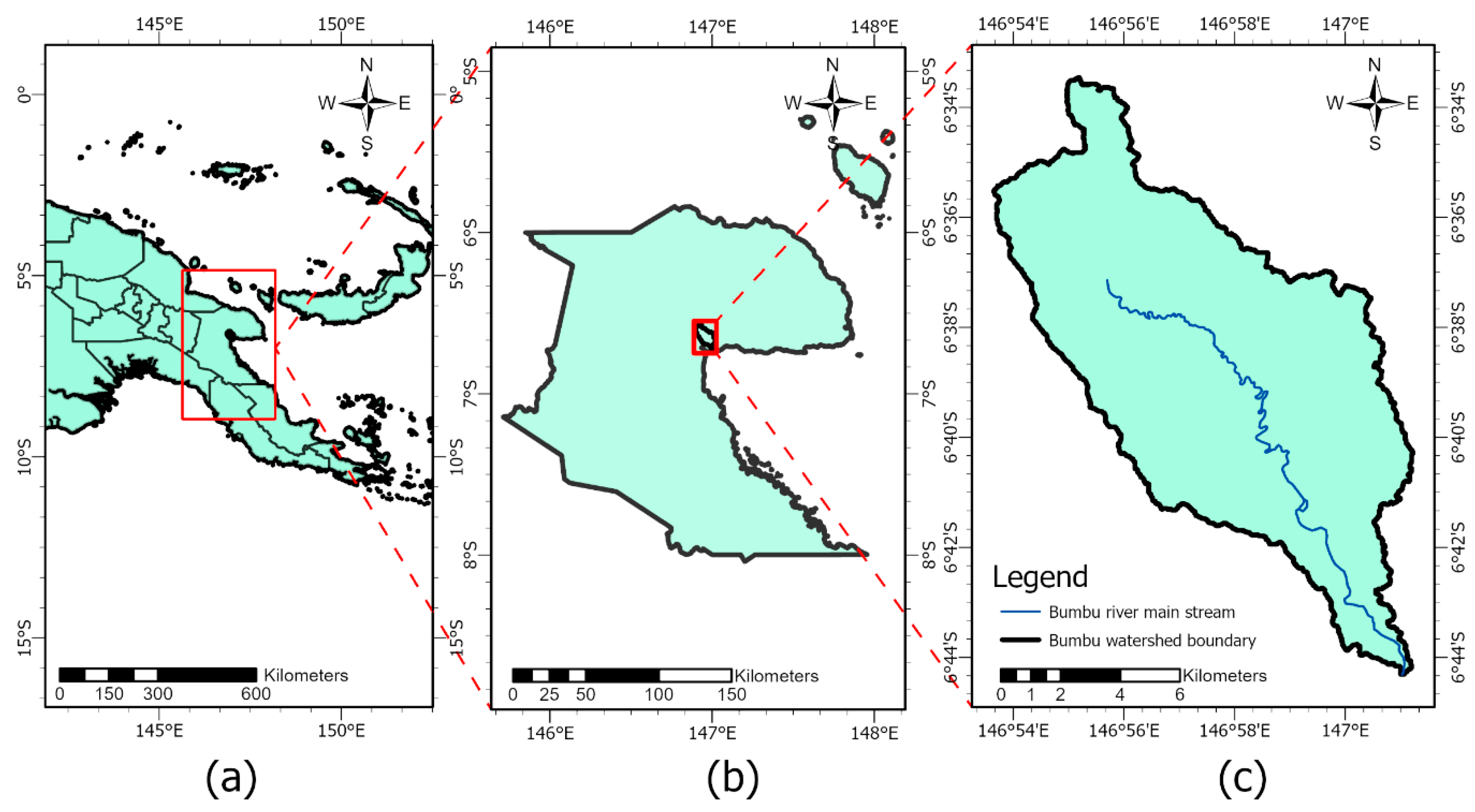
2.1. Study Area
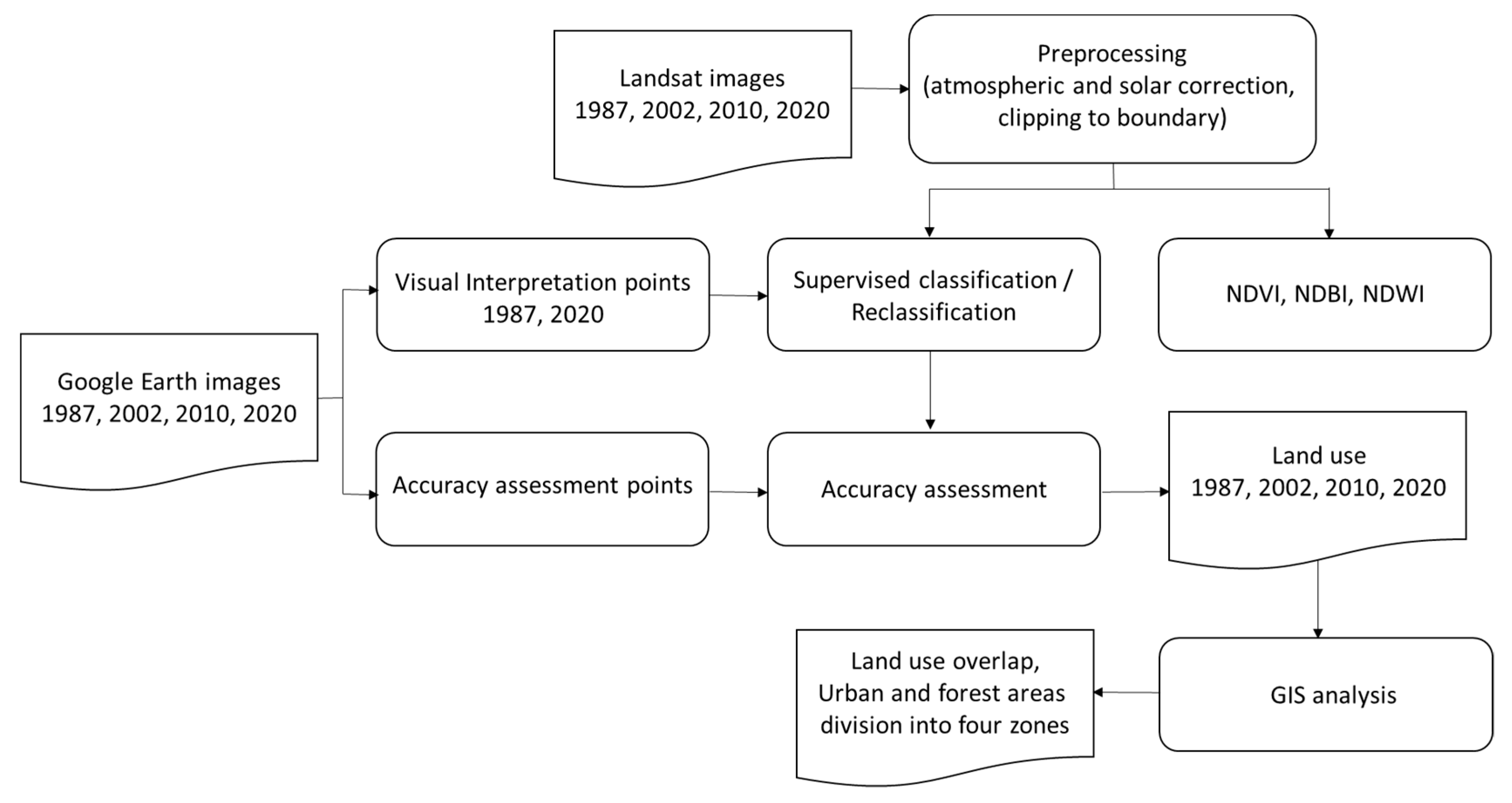
2.2. Data Collection/Preprocessing
2.3. Spatial Analysis
2.3.1. Pre-Classification
2.3.2. Supervised Classification
2.3.3. Re-Classification
2.3.4. Accuracy Assessment
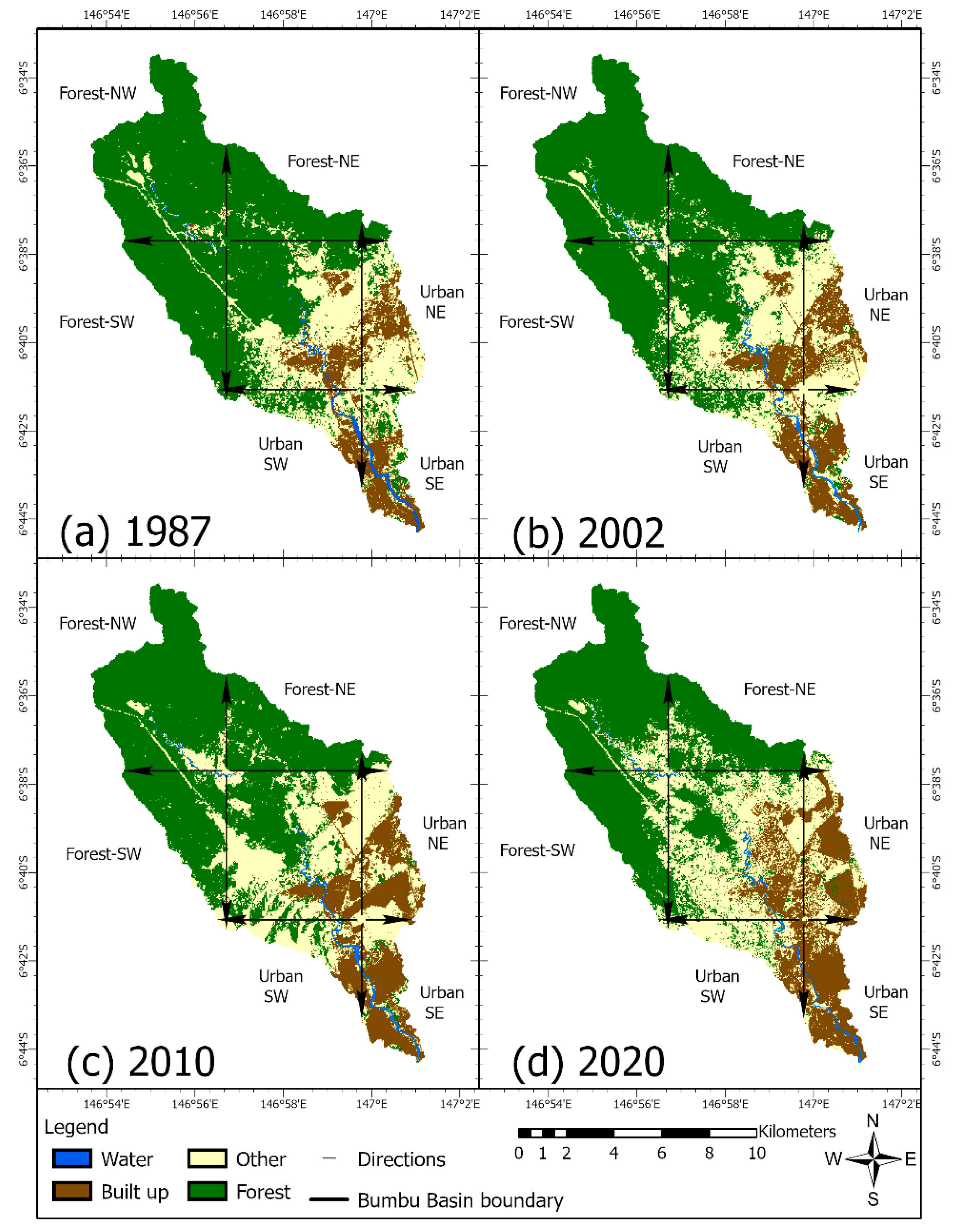
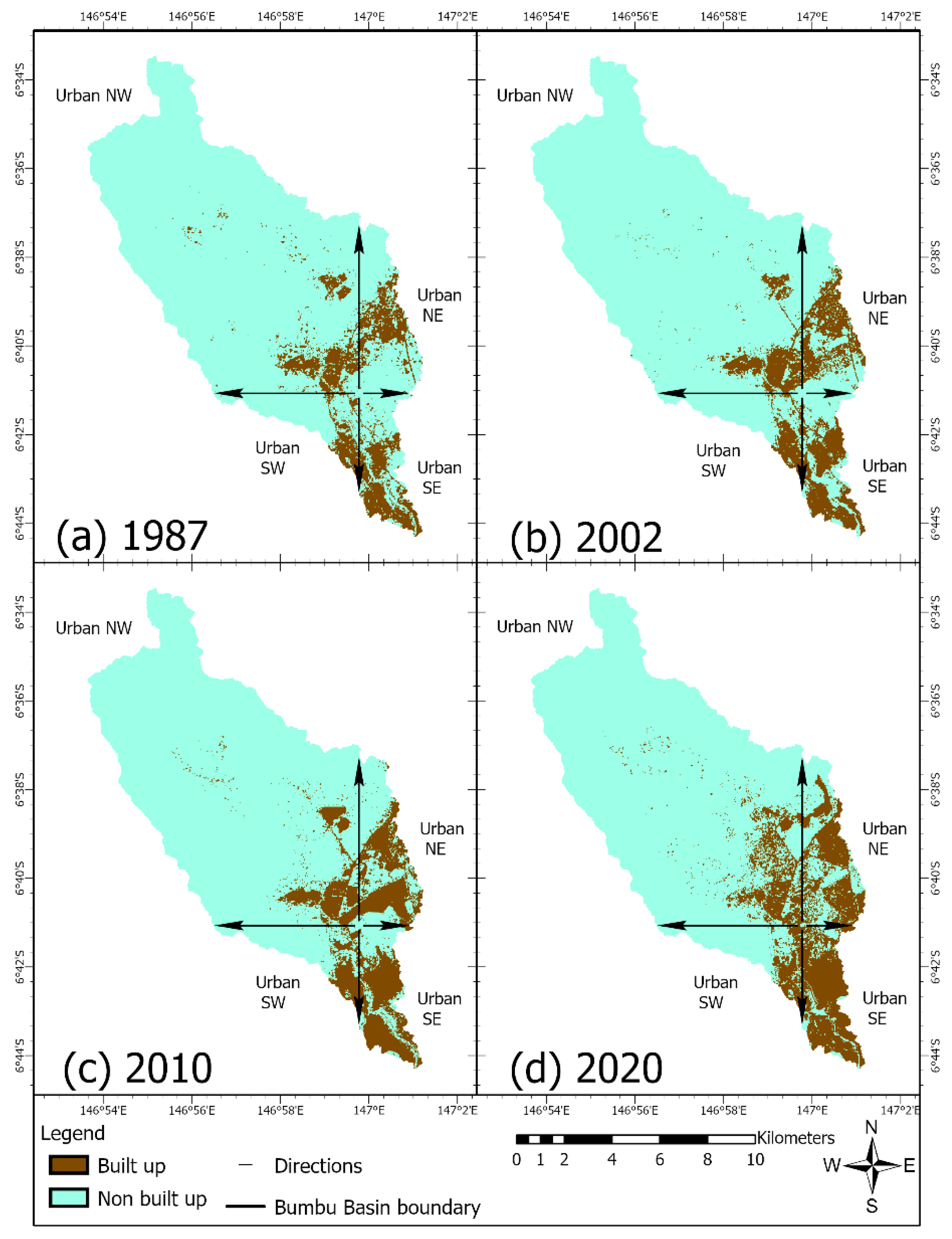
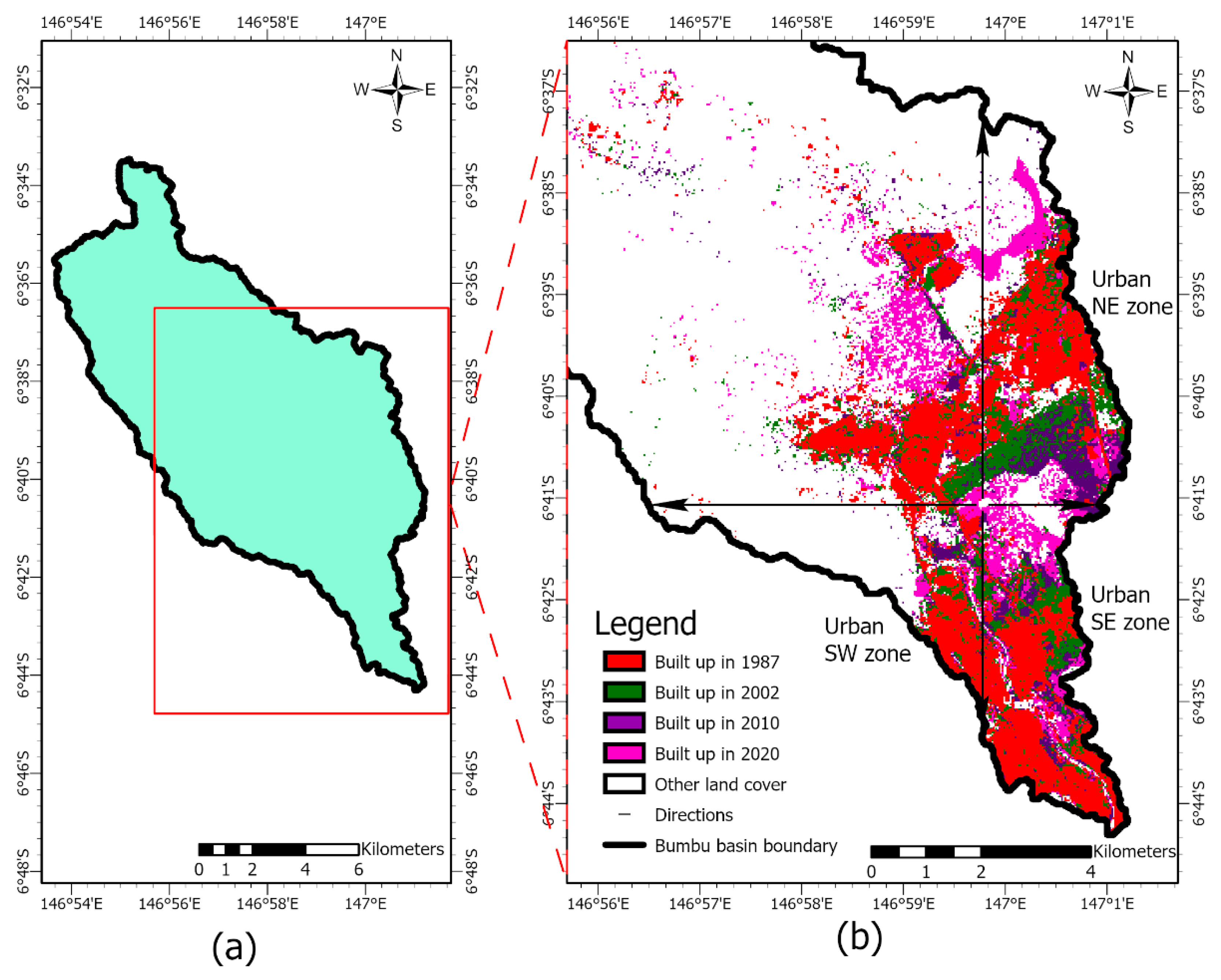
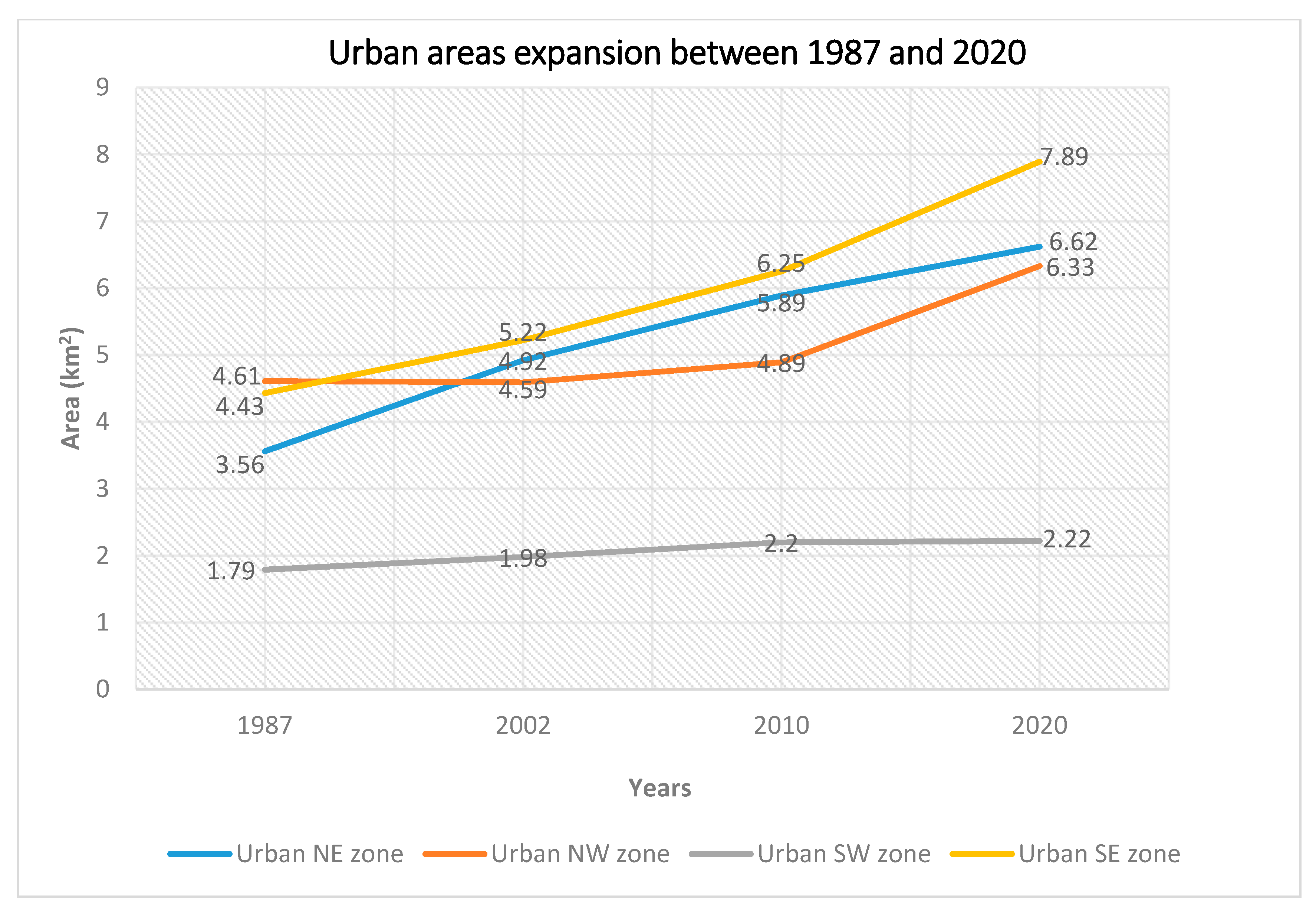
3. Results
4. Discussion
5. Conclusions
6. Future Tasks
6.1. Annual Land-Use Land Cover (LULC) Change Analysis
6.2. Improved Classification of Regenerated Forests
6.3. Integration with Water Quality Data
Author Contributions
Funding
Acknowledgments
Conflicts of Interest
References
- Watson, R.T.; Noble, I.R.; Bolin, B.; Ravindranath, N.H.; Verardo, D.J.; Dokken, D.J. Land Use, Land-Use Change and Forestry: A Special Report of the Intergovernmental Panel on Climate Change; Cambridge University Press: Cambridge, UK, 2000. [Google Scholar]
- Turner, B.; Meyer, W.B.; Skole, D.L. Global land-use/land-cover change: Towards an integrated study. Ambio. Stockh. 1994, 23, 91–95. [Google Scholar]
- Turner, B.L. The sustainability principle in global agendas: Implications for understanding land-use/cover change. Geogr. J. 1997, 163, 133–140. [Google Scholar]
- Braimoh, A.K.; Osaki, M. Land-use change and environmental sustainability. Sustain. Sci. 2009, 5, 5–7. [Google Scholar] [CrossRef] [Green Version]
- Sahoo, S.; Sil, I.; Dhar, A.; Debsarkar, A.; Das, P.; Kar, A. Future scenarios of land-use suitability modeling for agricultural sustainability in a river basin. J. Clean. Prod. 2018, 205, 313–328. [Google Scholar] [CrossRef]
- Hansen, A.J.; DeFries, R.S.; Turner, W. Land use change and biodiversity. In Land Change Science; Springer: Dordrecht, The Netherlands, 2012; pp. 277–299. [Google Scholar]
- Jaafar, W.S.W.M.; Maulud, K.N.A.; Kamarulzaman, A.M.M.; Raihan, A.; Sah, S.M.; Ahmad, A.; Saad, S.N.M.; Azmi, A.T.M.; Syukri, N.K.A.J.; Khan, W.R. The Influence of Deforestation on Land Surface Temperature—A Case Study of Perak and Kedah, Malaysia. Forests 2020, 11, 670. [Google Scholar] [CrossRef]
- Nelson, G.C.; Geoghegan, J. Deforestation and land use change: Sparse data environments. Agric. Econ. 2002, 27, 201–216. [Google Scholar] [CrossRef]
- Vadjunec, J.M.; Gomes, C.V.A.; Ludewigs, T. Land-use/land-cover change among rubber tappers in the Chico Mendes Extractive Reserve, Acre, Brazil. J. Land Use Sci. 2009, 4, 249–274. [Google Scholar] [CrossRef]
- Clark, S.; Bolt, K.; Campbell, A. Protected Areas: An Effective Tool to Reduce Emissions from Deforestation and Forest Degradation in Developing Countries; UNEP-WCMC: Cambridge, UK, 2008. [Google Scholar]
- Houghton, R.A. Tropical deforestation as a source of greenhouse gas emissions. Trop. Deforestation Clim. Chang. 2005, 13. [Google Scholar]
- Ningal, T.F.; Hartemink, A.E.; Bregt, A.K. Land use change and population growth in the Morobe Province of Papua New Guinea between 1975 and 2000. J. Environ. Manag. 2008, 87, 117–124. [Google Scholar] [CrossRef]
- Shearman, P.L.; Ash, J.; Mackey, B.; Bryan, J.E.; Lokes, B. Forest conversion and degradation in Papua New Guinea 1972–2002. Biotropica 2009, 41, 379–390. [Google Scholar] [CrossRef] [Green Version]
- Filer, C.; Keenan, R.J.; Allen, B.J.; McAlpine, J.R. Deforestation and forest degradation in Papua New Guinea. Ann. For. Sci. 2009, 66, 813. [Google Scholar] [CrossRef] [Green Version]
- Shearman, P.L.; Bryan, J.; Ash, J.; Mackey, B.; Lokes, B. Deforestation and degradation in Papua New Guinea: A response to Filer and colleagues, 2009. Ann. For. Sci. 2010, 67, 300. [Google Scholar] [CrossRef]
- Sasaki, N. Carbon emissions due to land-use change and logging in Cambodia: A modeling approach. J. For. Res. 2006, 11, 397–403. [Google Scholar] [CrossRef]
- Tang, L.; Shao, G. Drone remote sensing for forestry research and practices. J. For. Res. 2015, 26, 791–797. [Google Scholar] [CrossRef]
- Rex, F.E.; Silva, C.A.; Corte, A.P.D.; Klauberg, C.; Mohan, M.; Cardil, A.; Da Silva, V.S.; De Almeida, D.R.A.; Garcia, M.; Broadbent, E.N.; et al. Comparison of Statistical Modelling Approaches for Estimating Tropical Forest Aboveground Biomass Stock and Reporting Their Changes in Low-Intensity Logging Areas Using Multi-Temporal LiDAR Data. Remote. Sens. 2020, 12, 1498. [Google Scholar] [CrossRef]
- Hansen, M.C.; Potapov, P.V.; Moore, R.; Hancher, M.; Turubanova, S.A.; Tyukavina, A.; Kommareddy, A. High-resolution global maps of 21st-century forest cover change. Science 2013, 342, 850–853. [Google Scholar] [CrossRef] [Green Version]
- Hansen, A.J.; Neilson, R.P.; Dale, V.H.; Flather, C.H.; Iverson, L.R.; Currie, D.J.; Shafer, S.; Cook, R.; Bartlein, P.J. Global Change in Forests: Responses of Species, Communities, and Biomes. BioScience 2001, 51, 765–779. [Google Scholar] [CrossRef]
- Song, X.-P.; Hansen, M.; Stehman, S.V.; Potapov, P.V.; Tyukavina, A.; Vermote, E.F.; Townshend, J.R. Global land change from 1982 to 2016. Nature 2018, 560, 639–643. [Google Scholar] [CrossRef]
- Pratihast, A.K.; Devries, B.; Avitabile, V.; De Bruin, S.; Kooistra, L.; Tekle, M.; Herold, M. Combining Satellite Data and Community-Based Observations for Forest Monitoring. Forests 2014, 5, 2464–2489. [Google Scholar] [CrossRef] [Green Version]
- Popkin, G. Satellite alerts track deforestation in real time. Nature 2016, 530, 392–393. [Google Scholar] [CrossRef] [Green Version]
- Williams, D.L.; Goward, S.; Arvidson, T. Landsat. Photogramm. Eng. Remote. Sens. 2006, 72, 1171–1178. [Google Scholar] [CrossRef]
- Banskota, A.; Kayastha, N.; Falkowski, M.J.; Wulder, M.A.; Froese, R.E.; White, J.C. Forest Monitoring Using Landsat Time Series Data: A Review. Can. J. Remote Sens. 2014, 40, 362–384. [Google Scholar] [CrossRef]
- Yan, H.; Liu, J.; Huang, H.Q.; Tao, B.; Cao, M. Assessing the consequence of land use change on agricultural productivity in China. Glob. Planet. Chang. 2009, 67, 13–19. [Google Scholar] [CrossRef]
- Tomar, V.; Kumar, P.; Rani, M.; Gupta, G.; Singh, J. A satellite-based biodiversity dynamics capability in tropical forest. Electron. J. Geotech. Eng. 2013, 18, 1171–1180. [Google Scholar]
- Pettorelli, N.; Safi, K.; Turner, W. Satellite remote sensing, biodiversity research and conservation of the future. Philos. Trans. R. Soc. B Boil. Sci. 2014, 369, 20130190. [Google Scholar] [CrossRef] [PubMed]
- Kalnay, E.; Cai, M. Impact of urbanization and land-use change on climate. Nature 2003, 423, 528–531. [Google Scholar] [CrossRef]
- Sekac, T.; Jana, S.K. Change detection of Busu river course in Papua New Guinea-impact on local settlements using remote sensing and GIS technology. Int. J. Sci. Eng. Res. 2013, 5, 891–899. [Google Scholar]
- Irons, J.R.; Dwyer, J.; Barsi, J.A. The next Landsat satellite: The Landsat Data Continuity Mission. Remote Sens. Environ. 2012, 122, 11–21. [Google Scholar] [CrossRef] [Green Version]
- Jana, S.K.; Sekac, T.; Pal, D.K. Study of Changing River Courses and Estimation of Reduction of Available Land Reserved for Development in Lae City of Papua New Guinea using GIS and Remote Sensing Technology; International Journal of Advance Research, IJOAR: Singapore, 2014; p. 5. [Google Scholar]
- Crook, K.A. Quaternary uplift rates at a plate boundary, Lae urban area, Papua New Guinea. Tectonophysics 1989, 163, 105–118. [Google Scholar] [CrossRef]
- Young, N.E.; Anderson, R.; Chignell, S.M.; Vorster, A.G.; Lawrence, R.; Evangelista, P.H. A survival guide to Landsat preprocessing. Ecology 2017, 98, 920–932. [Google Scholar] [CrossRef] [Green Version]
- U.S. Geological Survey: Landsat 7 (L7) Data Users Handbook LSDS-1927; version 2.0; U.S. Geological Survey: Reston, VA, USA, 2019.
- U.S. Geological Survey: Landsat 8 (L8) Data Users Handbook LSDS-1574; version 5.0; U.S. Geological Survey: Reston, VA, USA, 2019.
- Zha, Y.; Gao, J.; Ni, S. Use of normalized difference built-up index in automatically mapping urban areas from TM imagery. Int. J. Remote Sens. 2003, 24, 583–594. [Google Scholar] [CrossRef]
- Hamad, R. A remote sensing and GIS-based analysis of urban sprawl in Soran District, Iraqi Kurdistan. SN Appl. Sci. 2019, 2, 24. [Google Scholar] [CrossRef] [Green Version]
- Hamad, R.; Kolo, K.; Balzter, H. Post-War Land Cover Changes and Fragmentation in Halgurd Sakran National Park (HSNP), Kurdistan Region of Iraq. Land 2018, 7, 38. [Google Scholar] [CrossRef] [Green Version]
- ESRI. ArcMap 10.2; ESRI: Redlands, CA, USA, 2014. [Google Scholar]
- Hsiao, L.-H.; Cheng, K.-S. Assessing Uncertainty in LULC Classification Accuracy by Using Bootstrap Resampling. Remote Sens. 2016, 8, 705. [Google Scholar] [CrossRef] [Green Version]
- Samanta, S.; Pal, D.K. Change Detection of Land Use and Land Cover over a Period of 20 Years in Papua New Guinea. Nat. Sci. 2016, 8, 138–151. [Google Scholar] [CrossRef] [Green Version]
- Wang, Q.; Blackburn, G.A.; Onojeghuo, A.O.; Dash, J.; Zhou, L.; Zhang, Y.; Atkinson, P. Fusion of Landsat 8 OLI and Sentinel-2 MSI Data. IEEE Trans. Geosci. Remote Sens. 2017, 55, 3885–3899. [Google Scholar] [CrossRef] [Green Version]
- Clerici, N.; Calderón, C.A.V.; Posada, J.M. Fusion of Sentinel-1A and Sentinel-2A data for land cover mapping: A case study in the lower Magdalena region, Colombia. J. Maps 2017, 13, 718–726. [Google Scholar] [CrossRef] [Green Version]
- Reiche, J.; Hamunyela, E.; Verbesselt, J.; Hoekman, D.; Herold, M. Improving near-real time deforestation monitoring in tropical dry forests by combining dense Sentinel-1 time series with Landsat and ALOS-2 PALSAR-2. Remote Sens. Environ. 2018, 204, 147–161. [Google Scholar] [CrossRef]
- Wang, T.; Kazak, J.K.; Han, Q.; De Vries, B. A framework for path-dependent industrial land transition analysis using vector data. Eur. Plan. Stud. 2019, 27, 1391–1412. [Google Scholar] [CrossRef]
- Mohan, M.; Silva, C.A.; Klauberg, C.; Jat, P.; Catts, G.; Cardil, A.; Hudak, A.T.; Dia, M. Individual Tree Detection from Unmanned Aerial Vehicle (UAV) Derived Canopy Height Model in an Open Canopy Mixed Conifer Forest. Forests 2017, 8, 340. [Google Scholar] [CrossRef] [Green Version]
- Zhang, J.; Hu, J.; Lian, J.; Fan, Z.; Ouyang, X.; Ye, W. Seeing the forest from drones: Testing the potential of lightweight drones as a tool for long-term forest monitoring. Boil. Conserv. 2016, 198, 60–69. [Google Scholar] [CrossRef]
- Noor, N.M.; Abdullah, A.A.A.; Abdullah, A.; Ibrahim, I.; Sabeek, S. 3D city modeling using MULTIROTOR drone for city heritage conservation. Plan. Malays. J. 2019, 17. [Google Scholar] [CrossRef] [Green Version]
- Cureton, P. Drone Futures: UAS in Landscape and Urban Design; Routledge: Abingdon, Oxfordshire, UK, 2020. [Google Scholar]
- Silva, C.A.; Valbuena, R.; Pinagé, E.; Mohan, M.; Almeida, D.R.A.; Broadbent, E.N.; Jaafar, W.S.W.M.; Papa, D.D.A.; Cardil, A.; Klauberg, C.; et al. F orest G ap R: An r Package for forest gap analysis from canopy height models. Methods Ecol. Evol. 2019, 10, 1347–1356. [Google Scholar] [CrossRef] [Green Version]
- Jaafar, W.S.W.M.; Woodhouse, I.H.; Silva, C.A.; Omar, H.; Maulud, K.N.A.; Hudak, A.T.; Klauberg, C.; Cardil, A.; Mohan, M. Improving Individual Tree Crown Delineation and Attributes Estimation of Tropical Forests Using Airborne LiDAR Data. Forests 2018, 9, 759. [Google Scholar] [CrossRef] [Green Version]
- Srinivasan, S.; Popescu, S.; Eriksson, M.; Sheridan, R.D.; Ku, N.-W. Multi-temporal terrestrial laser scanning for modeling tree biomass change. For. Ecol. Manag. 2014, 318, 304–317. [Google Scholar] [CrossRef]
- Srinivasan, S.; Popescu, S.; Eriksson, M.; Sheridan, R.D.; Ku, N.-W. Terrestrial Laser Scanning as an Effective Tool to Retrieve Tree Level Height, Crown Width, and Stem Diameter. Remote Sens. 2015, 7, 1877–1896. [Google Scholar] [CrossRef] [Green Version]
- Corte, A.P.D.; Rex, F.E.; De Almeida, D.R.A.; Sanquetta, C.R.; Silva, C.A.; Moura, M.M.; Wilkinson, B.; Zambrano, A.M.A.; Neto, E.M.D.C.; Veras, H.F.P.; et al. Measuring Individual Tree Diameter and Height Using GatorEye High-Density UAV-Lidar in an Integrated Crop-Livestock-Forest System. Remote Sens. 2020, 12, 863. [Google Scholar] [CrossRef] [Green Version]
- De Almeida, D.R.A.; Broadbent, E.; Zambrano, A.M.A.; Wilkinson, B.; Ferreira, M.; Chazdon, R.L.; Meli, P.; Gorgens, E.; Silva, C.A.; Stark, S.; et al. Monitoring the structure of forest restoration plantations with a drone-lidar system. Int. J. Appl. Earth Obs. Geoinf. 2019, 79, 192–198. [Google Scholar] [CrossRef]
- Brown, C. Asia-Pacific Forestry Sector Outlook Study; Working Papers Series; FAO: Rome, Italy, 1997. [Google Scholar]
- Ministry of Foreign Affairs of Japan. Protecting the Forests of Papua New Guinea. 2016. Available online: https://www.mofa.go.jp/files/000286363.pdf (accessed on 13 August 2020).


| Class | Description |
|---|---|
| 1-Water | Water bodies and wet river banks |
| 2-Urban/Built-up area | Residential, industrial, buildings occupied spaces, and transportation |
| 3-Other | Barren land, logging, slight vegetation, and agricultural land |
| 4-Forest | Forest and dense forest |
| Class | Water | Built-Up | Other | Forest | Total | User’s Accuracy (%) | Commission Error (%) | |
|---|---|---|---|---|---|---|---|---|
| Error Matrix 1987 | 1-Water | 43 | 0 | 0 | 0 | 43 | 100 | 0 |
| 2-Built-up | 0 | 43 | 1 | 3 | 47 | 91.5 | 8.5 | |
| 3-Other | 7 | 7 | 48 | 0 | 62 | 77.4 | 22.6 | |
| 4-Forest | 0 | 0 | 1 | 47 | 48 | 97.9 | 2.1 | |
| Total | 50 | 50 | 50 | 50 | 200 | |||
| Omission Error (%) | 14 | 14 | 4 | 6 | ||||
| Producer’s accuracy (%) | 86 | 86 | 96 | 94 | ||||
| Overall accuracy | 90.5% | |||||||
| Kappa | 0.87 | |||||||
| Error Matrix 2002 | 1-Water | 38 | 1 | 0 | 0 | 39 | 97.4 | 2.6 |
| 2-Built-up | 1 | 41 | 1 | 0 | 43 | 95.3 | 4.6 | |
| 3-Other | 10 | 8 | 48 | 3 | 69 | 69.6 | 30.4 | |
| 4-Forest | 1 | 0 | 1 | 47 | 49 | 95.9 | 4.1 | |
| Total | 50 | 50 | 50 | 50 | 200 | |||
| Omission Error (%) | 24 | 18 | 4 | 6 | ||||
| Producer’s accuracy (%) | 76 | 82 | 96 | 94 | ||||
| Overall accuracy | 87% | |||||||
| Kappa | 0.83 | |||||||
| Error Matrix 2010 | 1-Water | 44 | 0 | 0 | 0 | 44 | 100 | 0 |
| 2-Built-up | 2 | 46 | 0 | 0 | 48 | 95.8 | 4.2 | |
| 3-Other | 4 | 3 | 48 | 2 | 57 | 84.2 | 15.8 | |
| 4-Forest | 0 | 1 | 2 | 48 | 51 | 94.1 | 5.9 | |
| Total | 50 | 50 | 50 | 50 | 200 | |||
| Omission Error (%) | 12 | 8 | 4 | 4 | ||||
| Producer’s accuracy (%) | 88 | 92 | 96 | 96 | ||||
| Overall accuracy | 93% | |||||||
| Kappa | 0.91 | |||||||
| Error Matrix 2020 | 1-Water | 47 | 0 | 0 | 0 | 47 | 100 | 0 |
| 2-Built-up | 1 | 44 | 1 | 0 | 46 | 95.6 | 4.3 | |
| 3-Other | 1 | 4 | 42 | 2 | 49 | 85.7 | 14.3 | |
| 4-Forest | 1 | 2 | 7 | 48 | 58 | 82.8 | 17.2 | |
| Total | 50 | 50 | 50 | 50 | 200 | |||
| Omission Error (%) | 6 | 12 | 16 | 4 | ||||
| Producer’s accuracy (%) | 94 | 88 | 84 | 96 | ||||
| Overall accuracy | 90.5% | |||||||
| Kappa | 0.87 | |||||||
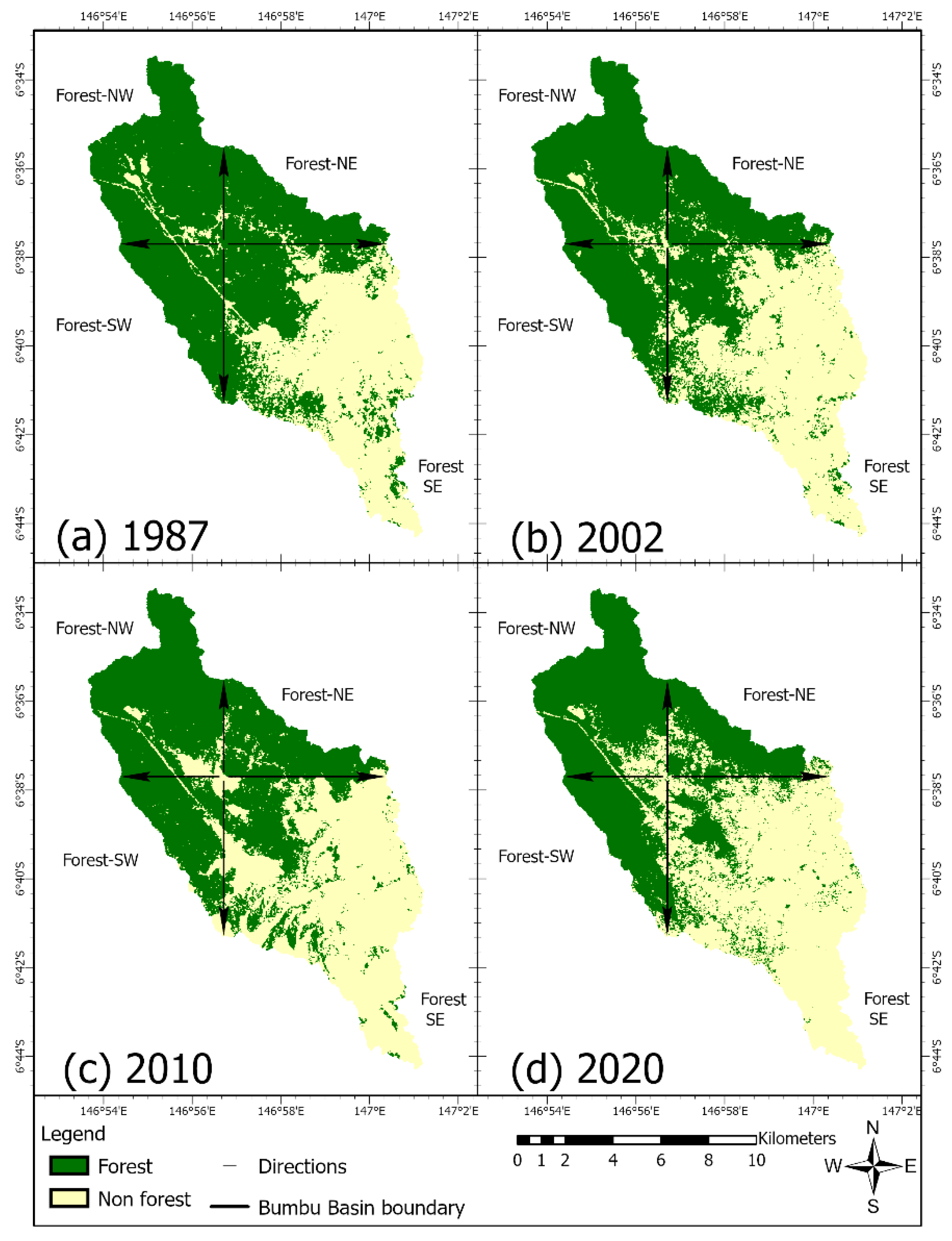
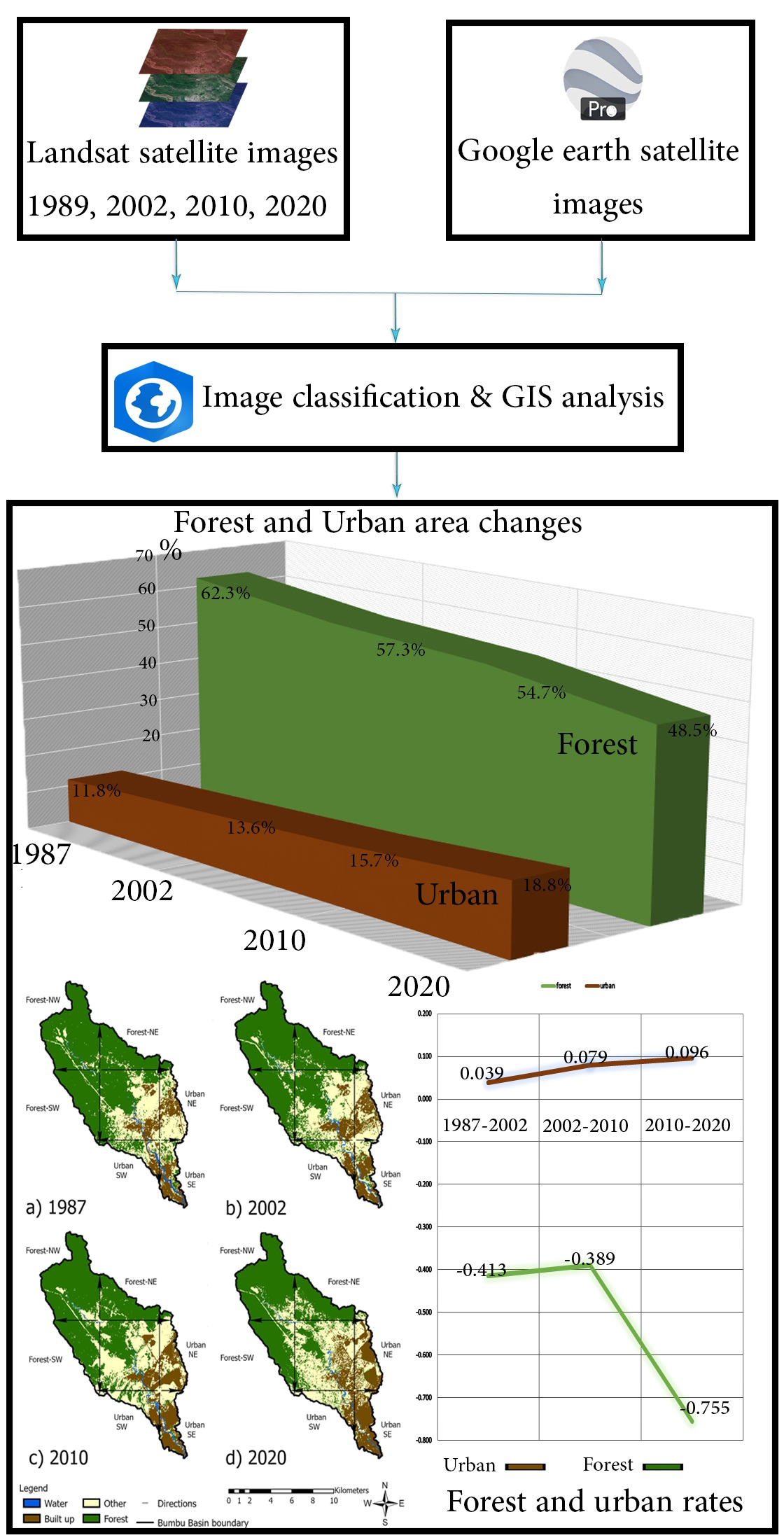
| Class Name | 1987 | 2002 | 2010 | 2020 | ||||
|---|---|---|---|---|---|---|---|---|
| km2 | % | km2 | % | km2 | % | km2 | % | |
| Water | 1.35 | 1.10 | 1.18 | 0.96 | 1.16 | 0.95 | 0.91 | 0.74 |
| Built-up | 14.39 | 11.76 | 16.71 | 13.65 | 19.23 | 15.71 | 23.06 | 18.84 |
| Other | 30.37 | 24.81 | 34.42 | 28.12 | 35.03 | 28.62 | 39 | 31.86 |
| Forest | 76.29 | 62.33 | 70.09 | 57.26 | 66.98 | 54.72 | 59.43 | 48.55 |
| Total | 122.4 | 100 | 122.4 | 100 | 122.4 | 100 | 122.4 | 100 |
| Zone/Period | 1987–2002 | 2002–2010 | 2010–2020 | Total (1987–2020) | ||||
|---|---|---|---|---|---|---|---|---|
| Area (km2) | Rate (km2 year−1) | Area (km2) | Rate (km2 year−1) | Area (km2) | Rate (km2 year−1) | Area (km2) | Rate (km2 year−1) | |
| Urban NE | 1.36 | 0.091 | 0.97 | 0.121 | 0.73 | 0.073 | 3.06 | 0.093 |
| Urban NW | −0.02 | −0.001 | 0.3 | 0.038 | 1.44 | 0.144 | 1.72 | 0.052 |
| Urban SW | 0.19 | 0.013 | 0.22 | 0.028 | 0.02 | 0.002 | 0.43 | 0.013 |
| Urban SE | 0.79 | 0.053 | 1.03 | 0.129 | 1.64 | 0.164 | 3.46 | 0.105 |
| Total Area | 2.32 | 2.52 | 3.83 | 8.67 | ||||
| Zone/Period | 1987–2002 | 2002–2010 | 2010–2020 | Total (1987–2020) | ||||
|---|---|---|---|---|---|---|---|---|
| Area (km2) | Rate (km2 year−1) | Area (km2) | Rate (km2 year−1) | Area (km2) | Rate (km2 year−1) | Area (km2) | Rate (km2 year−1) | |
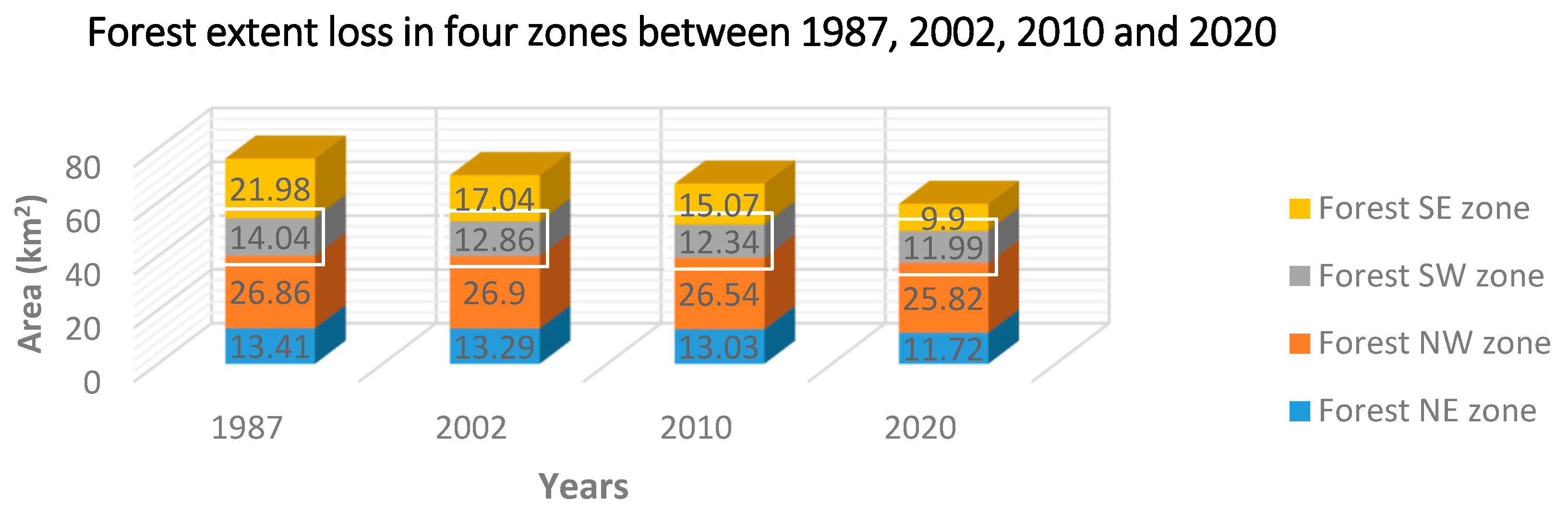
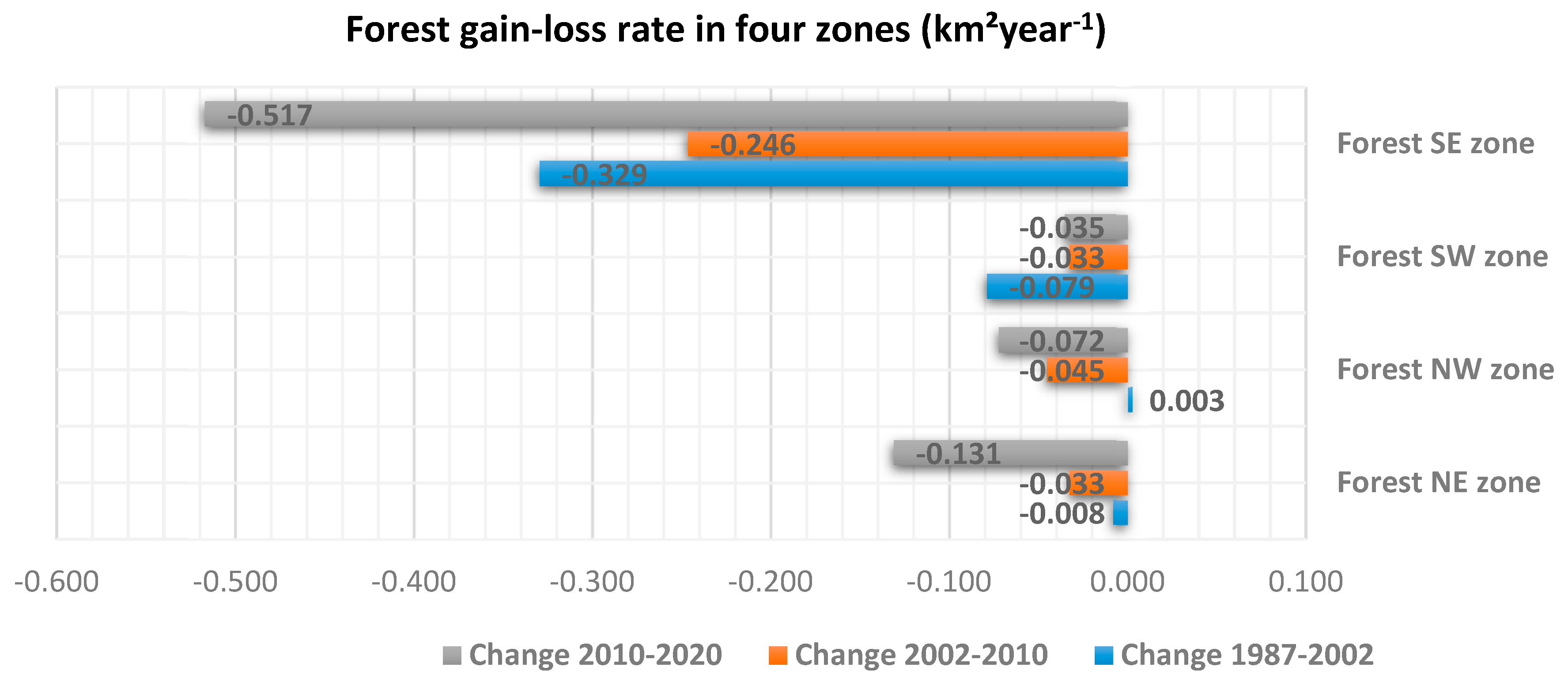
| Forest NE | −0.12 | −0.008 | −0.26 | −0.033 | −1.31 | −0.131 | −1.69 | −0.051 |
| Forest NW | 0.04 | 0.003 | −0.36 | −0.045 | −0.72 | −0.072 | −1.04 | −0.032 |
| Forest SW | −1.18 | −0.079 | −0.52 | −0.033 | −0.35 | −0.035 | −2.05 | −0.062 |
| Forest SE | −4.94 | −0.329 | −1.97 | −0.246 | −5.17 | −0.517 | −12.08 | −0.366 |
| Total area | −6.2 | −3.11 | −7.55 | −16.86 | ||||
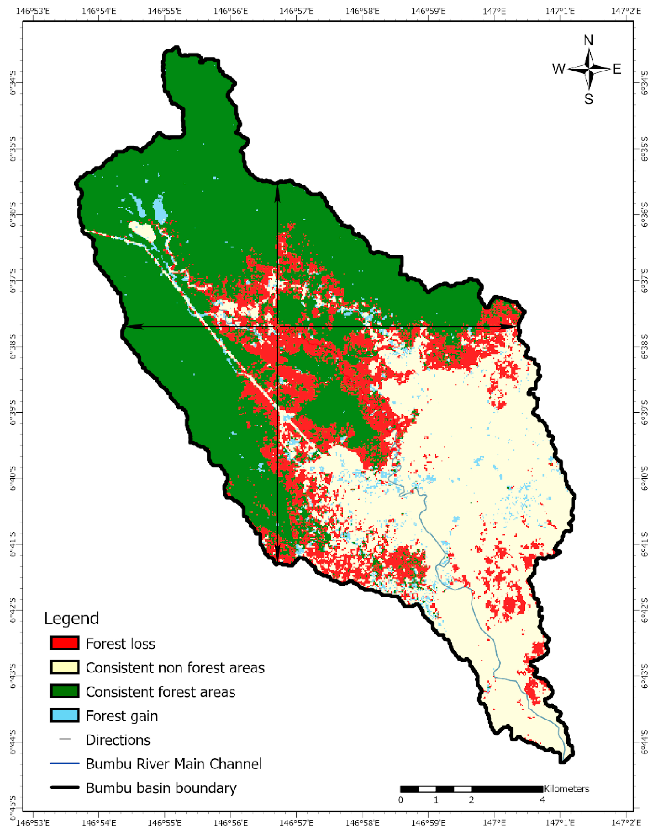
| Period | 1987–2020 Area Change (km2) |
|---|---|
| Consistent forest area | 56.29 |
| Consistent non-forest area | 42.98 |
| Forest gain | 3.15 |
| Forest loss | 20.01 |
© 2020 by the authors. Licensee MDPI, Basel, Switzerland. This article is an open access article distributed under the terms and conditions of the Creative Commons Attribution (CC BY) license (http://creativecommons.org/licenses/by/4.0/).
Share and Cite
Doaemo, W.; Mohan, M.; Adrah, E.; Srinivasan, S.; Dalla Corte, A.P. Exploring Forest Change Spatial Patterns in Papua New Guinea: A Pilot Study in the Bumbu River Basin. Land 2020, 9, 282. https://doi.org/10.3390/land9090282
Doaemo W, Mohan M, Adrah E, Srinivasan S, Dalla Corte AP. Exploring Forest Change Spatial Patterns in Papua New Guinea: A Pilot Study in the Bumbu River Basin. Land. 2020; 9(9):282. https://doi.org/10.3390/land9090282
Chicago/Turabian StyleDoaemo, Willie, Midhun Mohan, Esmaeel Adrah, Shruthi Srinivasan, and Ana Paula Dalla Corte. 2020. "Exploring Forest Change Spatial Patterns in Papua New Guinea: A Pilot Study in the Bumbu River Basin" Land 9, no. 9: 282. https://doi.org/10.3390/land9090282
APA StyleDoaemo, W., Mohan, M., Adrah, E., Srinivasan, S., & Dalla Corte, A. P. (2020). Exploring Forest Change Spatial Patterns in Papua New Guinea: A Pilot Study in the Bumbu River Basin. Land, 9(9), 282. https://doi.org/10.3390/land9090282