1. Introduction
In different places, particularly Europe and North America, sustainability plans and territorial planning at different scales recognise the benefits of ecosystems because they promote conservation and green infrastructure in the territory. There is limited guidance on how to conceptualize and use ecosystem services in the context of land use management and territorial planning [
1].
Territorial planning is a particularly relevant decision-making process in which instruments such as National Park Plans constitute political documents used to shape ideological positions. How relationships between humans and nature are built and which environmental issues should be prioritized are an important part of this ideological position [
2].
One of the most important aspects of territorial planning is the environmental dimension and its relationship with sustainable development. It is precisely in this sphere that ecosystem services should be evaluated, as National Park Management Plans must be seen as a tool for conserving the environment in which zoning proposals play an important role [
3]. Zoning protects ecologically rich areas, often excluded from development, which serve as open spaces, recreational areas, aeration corridors, ecological corridors and buffer zones (for example, parks and areas with vegetation). This is one of the spheres in which the evaluation of ecosystem services in the parks could be considered [
4].
The European Charter for Territorial Planning, approved in May 1983, defines territorial planning as “a scientific discipline, an administrative technique and a policy”, the objectives of which are summarized in the promotion of a balanced socio-economic development of regions, responsible management of natural resources, improvement in the quality of life and the protection of the environment. In Spain, competences in the area of Territorial Planning are transferred to Regional Areas.
Since the entry of Spain into the then European Economic Community, Spanish rural policy has been based primarily on community agricultural policy and its objectives, programs and financial instruments.
Finding that the Spanish rural environment continues to show a development differential with respect to the urban environment, especially in certain rural areas, has revealed the deficiencies of this essentially agrarian model, and the need to make a change in the approach of public policies which, in order to attend to frequently marginalized territories and populations, has had to move from an agrarian and sector approach, to one that is fundamentally territorial and integral [
5].
As a result, Law 45/2007, for the sustainable development of the rural environment, was promulgated on 13 December 2007. The foundations of an own rural policy are established as a State policy, fully adapted to the particular economic, social and environmental conditions of the Spanish rural environment, which allows the application of the instruments of European policies to complement conventional sector policies, to ensure sustainable development in the rural environment.
The analyses of the factors that affect a territory are often complex and unattainable. This has resulted in the drafting of comprehensive NPMPs (National Park Management Plans) that have been introduced, sometimes irregularly and inefficiently, in the territory, given the complexity of all the physical and social agents involved [
6].
The organization of the territory must serve to reduce and correct imbalances [
7] and create territorial cohesion and integration. This is associated with the coordination principle that some authors call “internal coherence”, which takes into account policies, imaginary landscape, visions of development and relations with the environment, recognizing diversity or heterogeneity within the territories [
8,
9].
Changes in the forms of production, consumption and mobility are affecting spatial organization. Global and local aspects are unimaginably connected [
10,
11]. Therefore, the repeated failure of plans as long-term anticipation of a territorial model demonstrates the simplicity of urban planning techniques and the complexity of the construction of the territory on which these techniques are applied [
12]. This reality brings to the foreground the sustainability of a land occupation model based on mass consumption of the three basic elements of the environment: soil, air and water [
13].
A qualitative methodology that simplifies the diagnosis of and comparison between different territories is applied, checking the planning carried out, its degree of compliance and assessing the impacts. A general solution involves the ability to predict or describe the state of the soil and territory in terms of state factors. The factorial approach that Jenny applied to soil is essentially an ecological one which treats it as a component of a larger ecosystem [
14,
15]. Previously, the interdependence of state factors and difficulty of quantifying these factors and states of the system have been the main obstacles to obtaining a solution [
16,
17]. These are common problems in the analysis of ecosystems and the territory as support, and methods have been developed to address and solve them [
18]. However, it is not easy to apply attempts to solve the state factor equation to complex system analyses [
19].
The purpose of this paper is to apply a qualitative approach to assess planning that has been applied to the territory and thus improve its implementation. The “factorial” approach considers the territory in the context of the ecosystem and the landscape, and the interrelationships between the territory and other factors. While the factor approach has been criticized by some soil scientists, it is widely used by ecologists, geomorphologists, geologists and others who treat the soil as part of an ecosystem or landscape mosaic. Although this utility does not depend on a solution to Jenny’s equation, as evidenced by geomorphologists [
20] (pp. 166–167), solutions have been sought for a long time [
15,
19,
21,
22].
The conceptual model of factors or factor equation has been widely used in environmental sciences. The main source of frustration for some scientists has been the effort to obtain a mathematical solution to the function [
15]:
where S is the soil (territory), and the annotations in brackets, climatic, biotic, topographic, parental material and time factors, respectively. The endpoints represent unspecified factors, such as wind deposition, which could be important locally, or others. It is believed that a general solution to the equation is not possible at this time, and that the best approach is to increase the number of solutions of the various univariate functions in a wide range of landscapes [
23,
24,
25]. The obstacles to a general solution are the complexity of the system and its interrelationships (that is, many degrees of freedom) and the difficulty of quantifying some factors. Hence, this function is qualitative. In this way, it can be applied to the territory, where several factors are also interrelated.
Several authors have proposed a reassessment of the problem, since the analytical systems and different methods are available to analyse the interrelations from qualitative information [
25,
26,
27]. These methods have been successfully applied to a series of problems in ecology, earth and environmental sciences, which are characterized by complex interdependencies between variables and quantification difficulties [
27,
28,
29,
30]. Thus, for instance, the factor equation provides a good index for the study of agrosystems [
26] because it links the factors that determine evolutionary processes. Its expression in the implicit form would be A (S, C, V, L, G, t) = 0 where S is equal to soil, C climate, V vegetation, L (lithos, rock, topography), G equals to geoform, the relief, and t the development time that includes the chronology and intensity of the other factors. These factors are not totally independent of each other. Climate, for example, can have an effect on the other factors, including changes in intensity which, associated with climatic pulsations, influence the degree of development of the agrosystem [
26], from the initial stage to the final or zonal, climax. The factor equation in its application to the analysis of soils can be expressed in the explicit form S = f(cl,o,r,p,t,& .) given by Jenny in 1941, which is still being transmitted today [
25,
29,
30].
The purpose and scope of Jenny’s state factor or factor equation is to provide the context and conditions within which the evolution of the territory is formed and developed. As Jenny [
15] (p. 385) says, “… the factors are not formatters, or creators, or forces: they are variables (state factors) that define the state of the system”. Jenny makes clear in his factorial approach that the soil component, or territory in our case, cannot be considered isolated from its physical and biotic environment. We also consider the human factor as intervention and modification of the territory [
30].
A geographical study will be carried out (climate, soil, rock, fauna, flora and human action), which can be applied to any territory. This methodology, based on the factor equation (or state factor), or CLORPT [
15], can be used by planning experts to unify criteria and be able to measure and summarize what degree of compliance has been made in that planning. The application of the factor equation indicates a positive or negative action on the territory, nature or landscape. Therefore, it is essential to follow an established order: first, an introduction to guide the work; second, a geographical diagnosis; third, a qualitative analysis of the application of the factor equation (table and result); finally, a final assessment that clarifies and strengthens the objectives set.
3. Results. Diagnosis of the Factor Equation
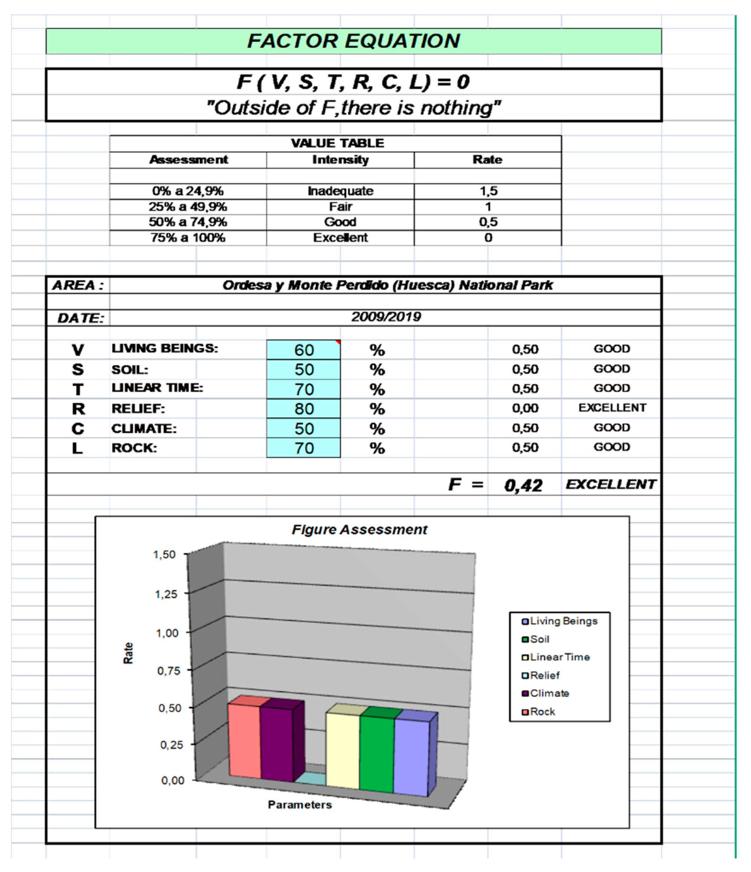
The Ordesa National Park Management Plan has been analysed. The final weight of the factors is reflected in the intensity given to them based on the analysis of the diagnosis of each one and the delphi survey.
Depending on the intensity of the different factors in the environment, we have assessed
Table 3, according to the following criteria:
3.1. Living Beings
(a) Vegetation: excellent intensity. In general, the main factors that condition the environment and vegetation development are: mountain climate, convergence of diverse climatic influences, altitude above sea level, geomorphological variation, location (solar orientation), situation of the North/South gradient, limestone substrate and slight human influence. The vegetation of the area has the following features:
Vegetation deeply conditioned by geomorphology and climate.
Wide representation of ecosystems corresponding to their extension, differences in altitude and existing slopes (from 700 m to 3500 m).
Three large units of vegetation, Mediterranean character, mountain character and high alpine mountains.
The flora of the Park consists of about 1400 species, which represents almost 45% of the Aragonese Pyrenees plants.
The potential vegetation of the area responds to climatic factors, as well as to the dominant topographic and lithological conditions, identifying, basically, with the deciduous forest of oaks, beech and pine trees. However, the current plant landscape is a clear example of the forest and pasture farms that have traditionally been worked by man in the area. This is due to the fact that the potential vegetation responds to topographic, climatological and lithological factors, configuring green spaces of utmost importance. Vascular plants are predominant in the Osca area. There are no threatened species in the Ordesa y Monte Perdido National Park. This is due, fundamentally, to social awareness, which is very acceptable from the point of view of nature and landscape conservation, in addition to following a correct operating pattern thanks in part to the public bodies of Aragón. There are no threatened species at present but, in recent years, the landscape of the National Park has changed considerably, and this causes biodiversity problems when alien species are introduced, either intentionally or accidentally found outside their natural range. The species are as follows:
- -
Asparagus officinalis (asparagus).
- -
Juglans orientalis (walnut).
- -
Fair medicine (alfalfa).
- -
Prunus sativa (plum).
- -
Pyrus dulcis (peral)
- -
Rosa gallica (rosal).
(b) Fauna: good intensity. The Ordesa y Monte Perdido National Park, being located between Continental and Mediterranean Europe, has numerous wildlife species of different types. As can be seen, it has an abundant number of birds (capercaillie, bearded vulture, golden eagle, black vulture, etc.) in the high mountain areas, but not as many as the average of National Parks. In clear contrast, there are a significant number of mammals (54), practically doubling the average of National Parks; clear examples would be: roe deer, wild boar, otters, etc. The rest of the fauna (reptiles, amphibians and fish), bear little weight in terms of quantity and importance; In addition, as in the case of fish, the number is much lower than the average of National Parks, as is logical. In the case of amphibians, only the Pyrenean triton is worth mentioning. Finally, although the vertebrate fauna in the National Park is a good example of variety and quantity, it is below average, due to the shortage of the three groups named above. There are some threatened species and others with few specimens. The great variety of environments determines great fauna richness and a wide representation of animal species. The greater or lesser presence of bird species marks the influence of the vegetal floors: in the upper levels of altitude, only 27% of the known species in Upper Aragon are represented; in the subalpine pine forests and scrublands, the number of species rises to 49%; at the montane level, 74% of the species are reached and the population becomes much more varied, and on the Mediterranean floor, abundance reaches 99%. From the point of view of biological wealth, one of the fundamental points is vertebrate fauna.
(c) Anthropic element: good intensity. Humanized landscape job creation within the park and in the nearby towns or villages, but this involves pollution of nature and the environment, since in addition, it has an important contingent of visitors. The presence of population in the environment is due to factors such as the splendid landscapes and its important hydrographical network and low demographic pressure. The influx of visitors is increasing and has had to be regulated at certain times such as Easter and summer in recent years. There is a humanized Pyrenean landscape around the Ordesa y Monte Perdido National Park. The influence of human beings can be seen, to a large extent, in the Sobrarbe area and National Park, in two ways:
Positively: job creation within the National Park and in nearby towns or villages.
Negatively: pollution of nature and the atmosphere, threat to flora and fauna, alteration of biodiversity and ecosystems and plant endemism.
3.2. Soil
(a) Support
Edaphology: fair intensity. Soils, according to their functionality, have a lot to do with lithology; because they are limestone type soils, with numerous chemical weathering processes, they are very poor for agricultural and livestock activities. Also, as a consequence of the almost complete existence of limestone soil in the Ordesa y Monte Perdido National Park, soils are significantly degraded or destroyed due to: weathering, erosion, transport and sedimentation. The problem is made worse by constant rain and snow, which significantly affects the development of plants and, to a lesser extent, fauna existing in the area. However, there are good pastures for livestock in the valleys.
Water: good intensity. The hydrological regime of the two great rivers of the Park, the Ara and the Cinca, is of the snowy type, that is to say, the greatest flows occur with the spring thaw. The shortage of winter precipitation (compared to equinoctial stages) and, above all, cold temperatures explain the prolonged period of low water levels in these rivers between December and March. Innovation in the area has a great hydrological and geomorphologic influence, especially due to rainfall in late winter and early spring. There is debugging in the cores and any spillage without purification is prohibited. As a result, there are hardly any lakes while the underground systems are extensive, being able to overcome slopes of more than 1000 m that emerge in upwellings, giving rise to a surface hydrographic network.
(b) Support System
Road network: fair intensity. This is due to the existence of important infrastructure, which is concentrated in Barbastro and Sabiñánigo, leaving the rest of the territory connected by secondary and tertiary roads. The existing road network has given little response to the large influx of visitors and access is regulated. In general, the existing road constitutes a system of low-level service with many critical points, some of them very dangerous, to which we must add the strong limitations of the large number of physical barriers in the territory. The infrastructure and installations in the nuclei must be improved, maintaining the environmental and cultural values present there, and restricting residential actions outside the existing ones. It is about making conservation compatible with reasonable and controlled urban development, respecting the rights of the inhabitants.
Railway network: Fair intensity. There are only two railway stations in Monzón and Sabiñánigo.
Energy infrastructure-electricity: good intensity. High voltage power line in the Bujaruelo valley from Lapazosa hill to the San Antón ravine, and the Nerín supply power line.
Natural gas: inadequate intensity. Practically non-existent.
Telecommunications: good intensity. There is an automatic weather station belonging to the European Reintegration Network (ERIN), in Lapazosa and Fanlo, and a phone line from Fanlo to Nerín. The provision of a telecommunications infrastructure, both in coverage and service capacity, reflects imbalances in the field.
Supply-sanitation: good intensity. The municipalities are supplied with water and wastewater treatment, although the slope and dispersion of the population make it difficult and water purification is more expensive. All inhabitants have their water purified. The implementation of the water treatment plant was a great benefit for the hydrographic network, although with a scrupulous control of discharges within the park, since all the nuclei of the protection zone must have their water purified and spillage is not allowed inside the Park.
Solid urban waste: good intensity. All municipalities have an MSW collection service, although still pending expansion and generalization (recycling and treatment), which is difficult, since the dispersion of the population in very small towns greatly complicates waste management, making it more costly.
Services and equipment: good intensity. Services and equipment are acceptable, the population level is low and most inhabitants work in the farming sector.
Population mobility: fairly reduced due to the fact that the villages in the area are very small and considerably difficult to access. In general, the existing road constitutes a system of low-level service with many critical points, some of them very dangerous, to which we must add the strong limitations of the large number of physical barriers in the territory. The infrastructure and installations in the nuclei must be improved, maintaining the environmental and cultural values present there, and restricting residential actions outside the existing ones.
Industrial land: inadequate intensity. Non-existent.
Logistics platform: inadequate intensity. Non-existent.
3.3. Relief
Excellent intensity. Regarding the relief, we find an excellent result, with 80%. This is because it conditions the rest of geographic factors directly and indirectly. In addition, it is very rich in geological forms, thanks to the diversity of existing heights (from 700 to 3500 metres). In general, it presents a mosaic of ecosystems with great floristic and fauna diversity (combination of glacial and karstic modelling, canyons and valleys, and variability of climatic altitude and orientations throughout the Park). Therefore, it can be said that it constitutes a landscape of true contrasts:
Extreme dryness of the highlands.
Green valleys covered with forests and meadows crossed by water in the form of waterfalls.
Diversity of plant formations
The morphology of the National Park is a fundamental part of its relief. It has the following characteristics:
The basic morphology of the Park is due to two orogenies, but mainly, to the folding and alpine elevation of the Tertiary era, later moulded by glacial erosion during the Quaternary era, giving rise to a series of clearly defined glacial valleys and cirques.
Two key areas can be distinguished within the relief (the high areas of the park (altitudes above 2000 m) are extremely arid, since all the water from precipitation is quickly collected by the karst system), and the bottoms of the valleys (covered with lush vegetation dominated by beech and fir trees).
Tenacious modelling work of glacial ice, the most precise manifestations of which are the typical trough profile of the valley or the remains of the ancient Quaternary glaciers still present at the highest altitudes.
3.4. Climate
Good intensity due to air quality being rated as good to very good. Occasional flooding can occur during equinoctial periods, and permanent cold and intense frosts hinder the stability of people in populations in Sobrarbe. However, these negative effects are palliated “relatively” by the surplus of water; that is to say, there are no periods of drought or related problems and with this the quantity and diversity of vegetation is increased. The most important factors that are, or may be, involved in the definition of a mountain climate are: altitude, latitude, orientation and continentality. Strong thermal contrasts as the atmosphere become weaker and permeable due to height. The orientation or arrangement of the relief establishes sharp contrasts between sunny and shady spots, and between rainy slopes windward and dry slopes leeward due to the Foehn effect. Differences between the north and south slopes: the former is colder and cloudier than the latter but receives a greater volume of rainfall because the southwest winds are wetter than those from the northwest.
3.5. Rock
Good intensity. It is evaluated while taking into account the difficulty of the land for human activities of management and agriculture. Limestone and limestone formations predominate in mountainous landscapes, while depressions are formed by alluvial terraces of marls, sandstones and silts, as well as molars and glazes of mineral matrix. The rock is related to the relief and the ground, that is, with two geographical factors analysed; the result is good, since the rock will adjust to the result previously extracted. Most of the rock in the National Park is limestone, overlaying the karst and river erosion of the landscape with multiple caves, canyons, chasms, etc.
3.6. Linear Time
Good intensity. The park has exceptional qualities in terms of landscape, lithological, relief and climate values, although, in terms of soils, infrastructure and socio-economic flows it must be improved. Regarding ecological/historical time, it has been observed how, through a chronological follow-up based on the National Park legislation, the Sobrarbe town of Oscense has evolved in a very favourable way socially and economically. From the 80s onwards, there has been a transformation in the National Park, thanks to protection and conservation measures, the creation of the NPMP, etc., although there is a negative element, which is the sign of human action on the territory.
Many changes have occurred in the National Park since its creation (1918) until the present, both from natural (climate, vegetation, relief …) and social and economic perspectives, promulgated through laws. The most significant are:
- -
August, 1918:
Declaration of the National Park.
Regulation and application of provincial and regional boundaries.
Natural aspects and nature conservation not promoted.
- -
Expansion and reclassification in 1982 (important transformations):
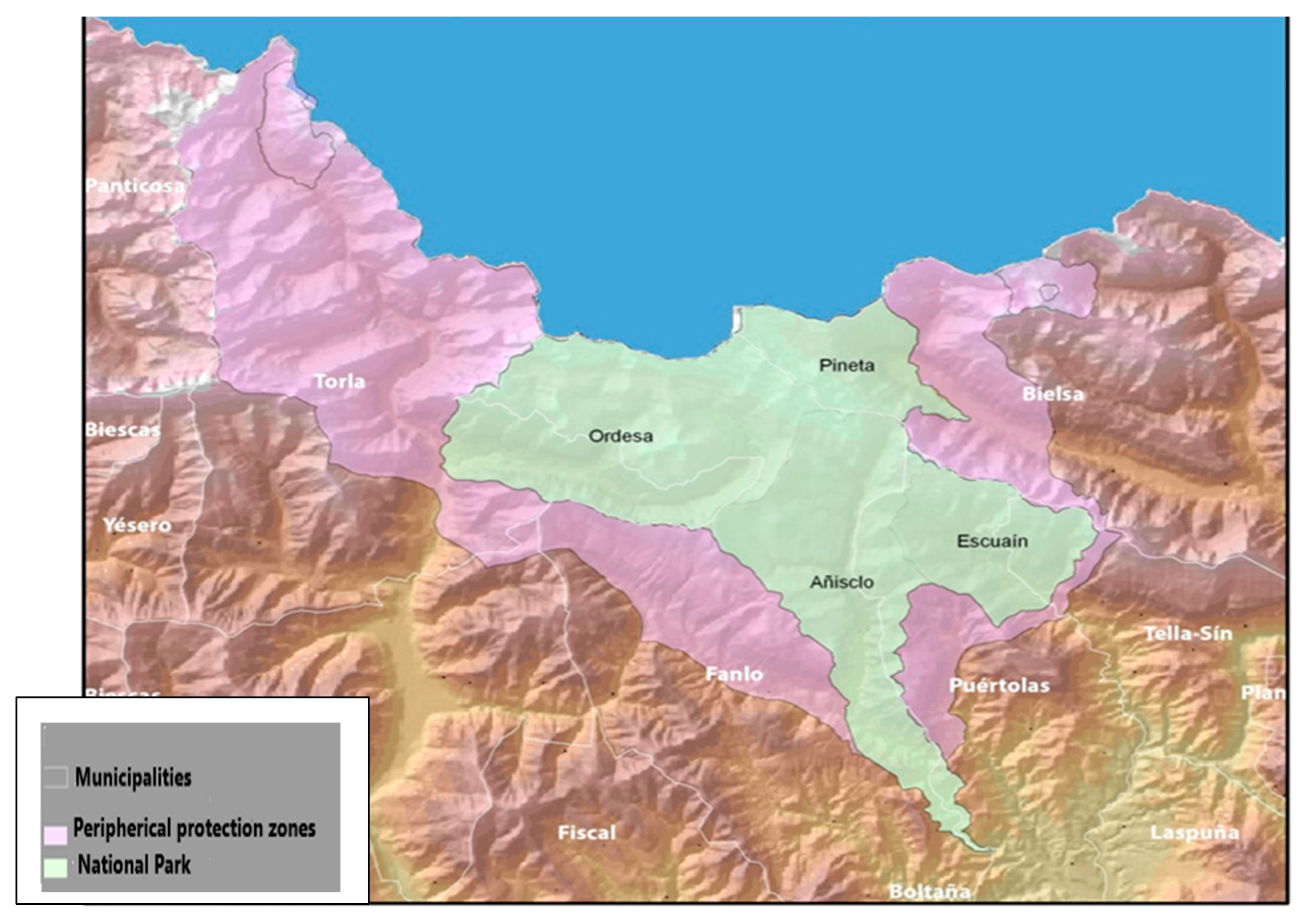
The Ordesa y Monte Perdido National Park, with a total area of 15,608 hectares, includes the municipalities of Bielsa, Fanlo, Puértolas, Tella-Sin and Torla, in the province of Huesca.
No activity may be carried out that could alter the elements and dynamic of the ecosystems in the National Park.
The first National Parks Management Plan (NPMP), which deals with uses of farming activity, was implemented.
National Park territory is classified to all intents and purposes as non-urbanizable land under special protection.
- -
80s and 90s:
Evident changes in supranational networks.
Approved certification and appointments: UNESCO World Heritage, Conservation Diploma, Biosphere Reserve, SPA (Special Protection Areas for birds).
- -
National Parks Management Plan approval in 1995, with the following changes:
- -
Zoning:
The superficial distribution of the different areas is as follows: Reserve land: 770 hectares, Areas of restricted use: 14,817.03 hectares, Areas of moderate use: 11.11 hectares, Areas of specialised use: 8.86 hectares, Development for public use and areas of special cultural, natural and geological importance.
- -
ROYAL DECREE 117/2005, of 24 May:
- -
ROYAL DECREE 778/2006, of 23 June:
Functions and services of the State Administration transferred to the Autonomous Region of Aragón, related to nature conservation.
Two types of values are established: Natural and Cultural.
- -
ROYAL DECREE 49/2015, of 8 April:
In short, the evolution of the Ordesa y Monte Perdido National Park has changed significantly over time, as we have observed in the legislation.
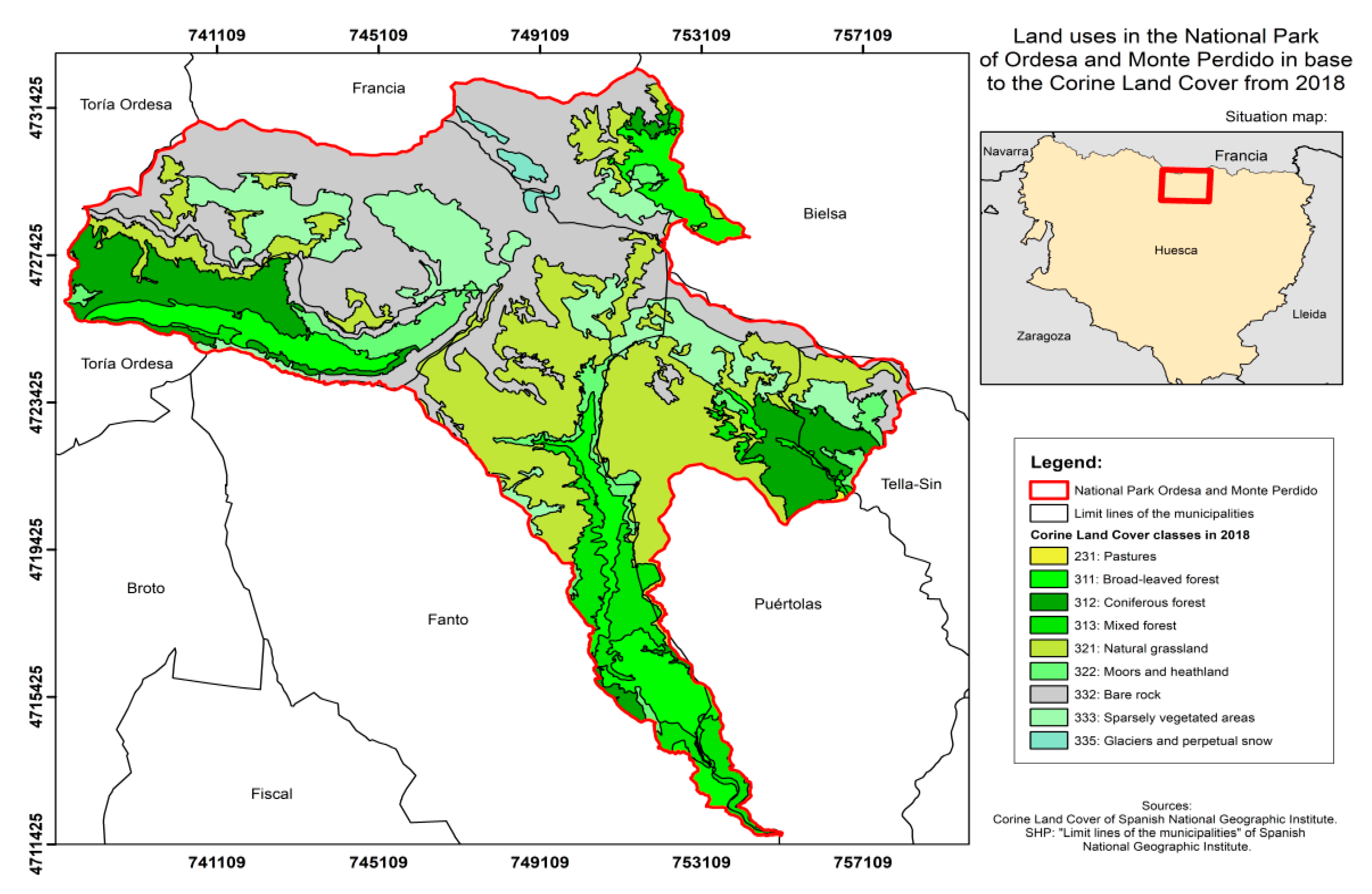
The analysis of the National Park diagnosis has a final result of 0.42, which is excellent (as close as possible to 0). This park has a whole humanized landscape in its surroundings. The houses are built in the typical architectural style of Aragón. Special protection is established for traditional livestock activities, compatible with the conservation of the environment, which have helped shape the landscape and configure some of its most characteristic systems (
Table 1,
Figure 1).
Growing sensitivity to issues related to nature conservation has delayed projects of new transit routes which, for some time, were considered necessary for the maintenance of mountain populations. The two sections of road that enter the park are subject to strict regulation, and are occasionally closed to maximum influx resulting in the introduction of alternative collective transport to access the interior of the park. New constructions are subject to strict regulations.
The Ordesa y Monte Perdido National Park has exceptional qualities in terms of landscape, lithology, fauna, flora, relief and climate. Its territorial-environmental value is mainly landscape and nature.
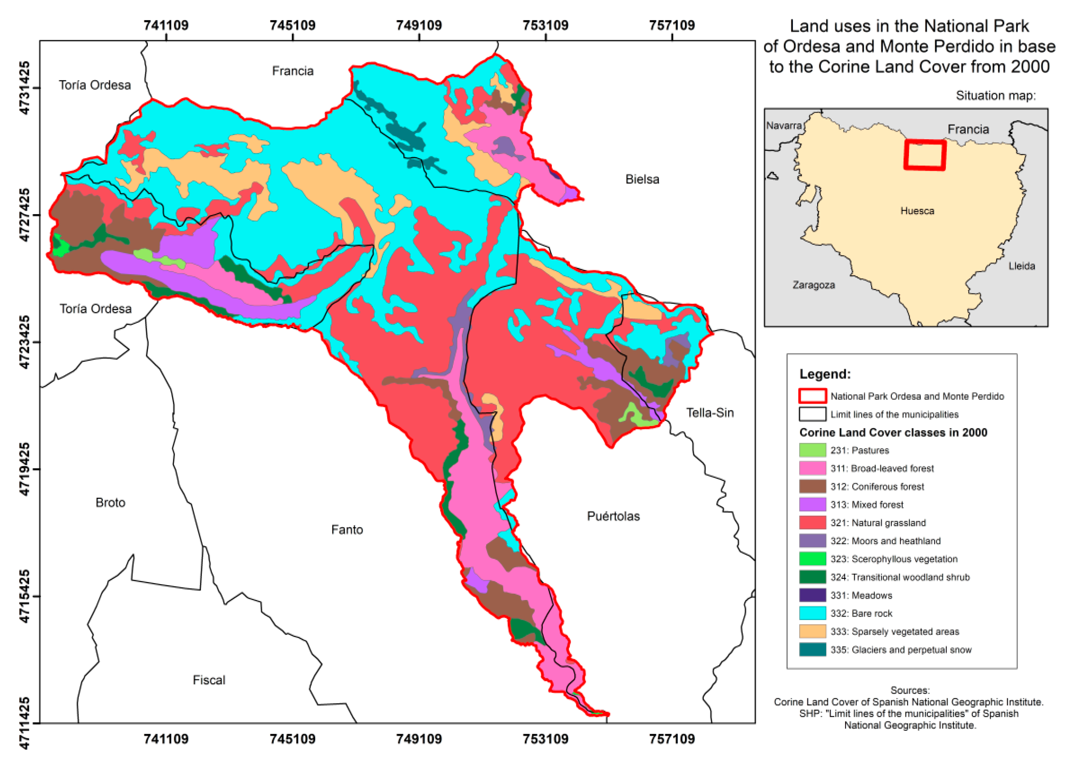
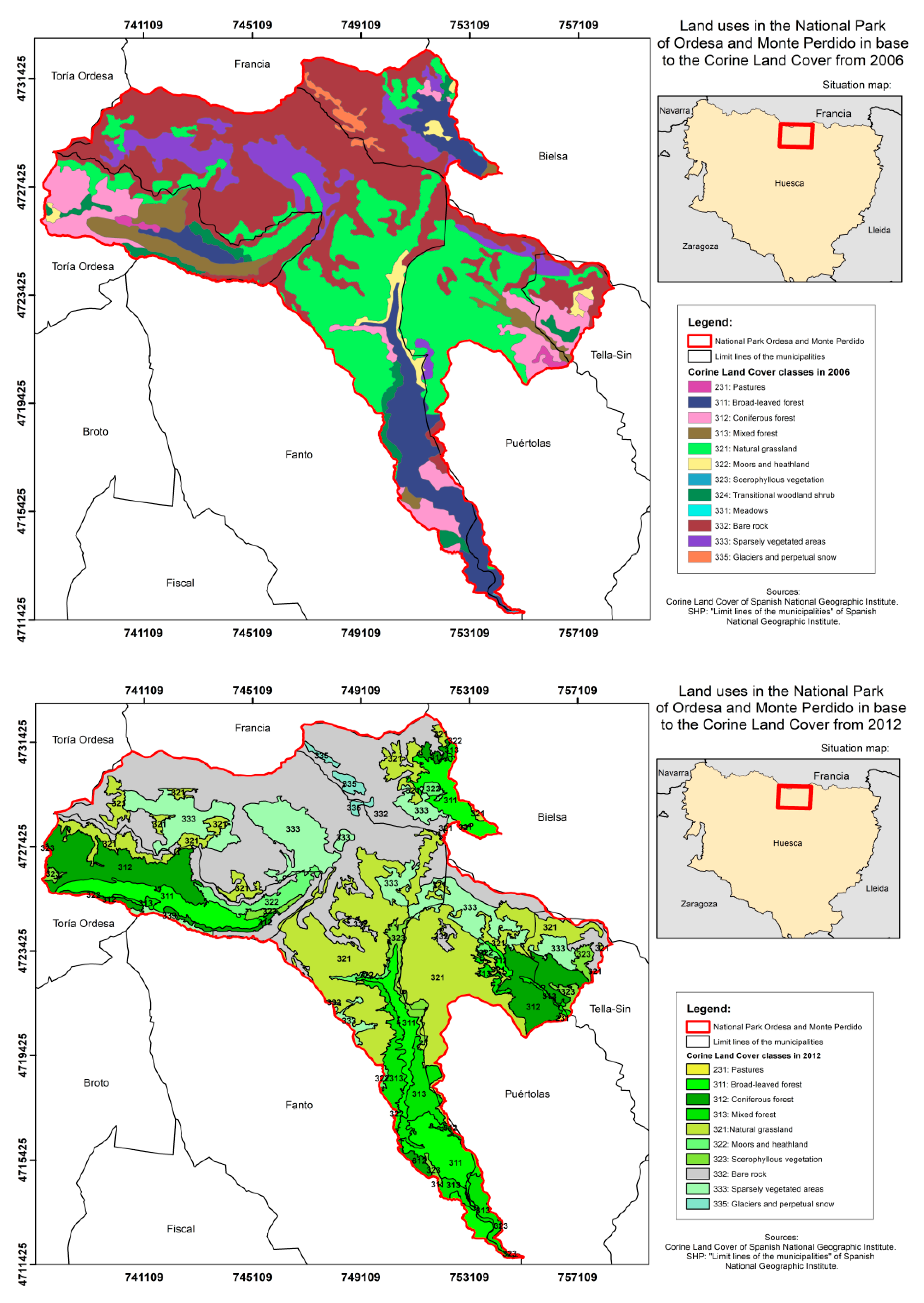
Fewer noticeable changes have taken place in the shape and structure of the territory [
34]. Land use has changed little between 2000 and 2018, as can be seen in the maps taken from the Corine land cover (
Figure 3).
4. Discussion
The advantages of using this qualitative model is that both objective and subjective attributes can be used, as long as the subjective attributes can be converted into scores with a wide range (assessment, intensity, rate) (
Figure 3) and the experts’ opinion can be found in these ranges. Besides, we can easily identify latent problems when making the diagnosis. Using this system, a numerical value is assigned to each factor in the equation after making the diagnosis. Each numerical evaluation is then assigned a qualitative score. The same is applied to the whole group of factors, obtaining an alpha numerical value as the result, which will guide us through the weaknesses and/or strong points of the park(s) from a territorial and spatial perspective, as they indicate a positive or negative action on the territory/land, nature or landscape.
One of the disadvantages is that how useful this method is depends on the capacity of the researchers to compile a sufficient set of attributes. If important attributes are excluded or overlooked, the value of the procedure is reduced. If the sets of variables observed are very similar to each other and different from other elements, they will be assigned only one factor by the state factor analysis. This analysis requires knowledge of planning and of each factor as some of them are correlated.
This simple qualitative methodology simplifies diagnosis and comparison between different territories. Thus, we can verify the planning performed and analyse its impacts. The state factor equation (CLORPT) can be used by experts in planning to unify criteria and measure and sum up to what extent the planning has been carried out. Using this systematization, we can deal with the mutual interrelationships in time much more easily. The CLORPT function enables us to understand the potential of the park or territory and manage them in order to reach their full potential.
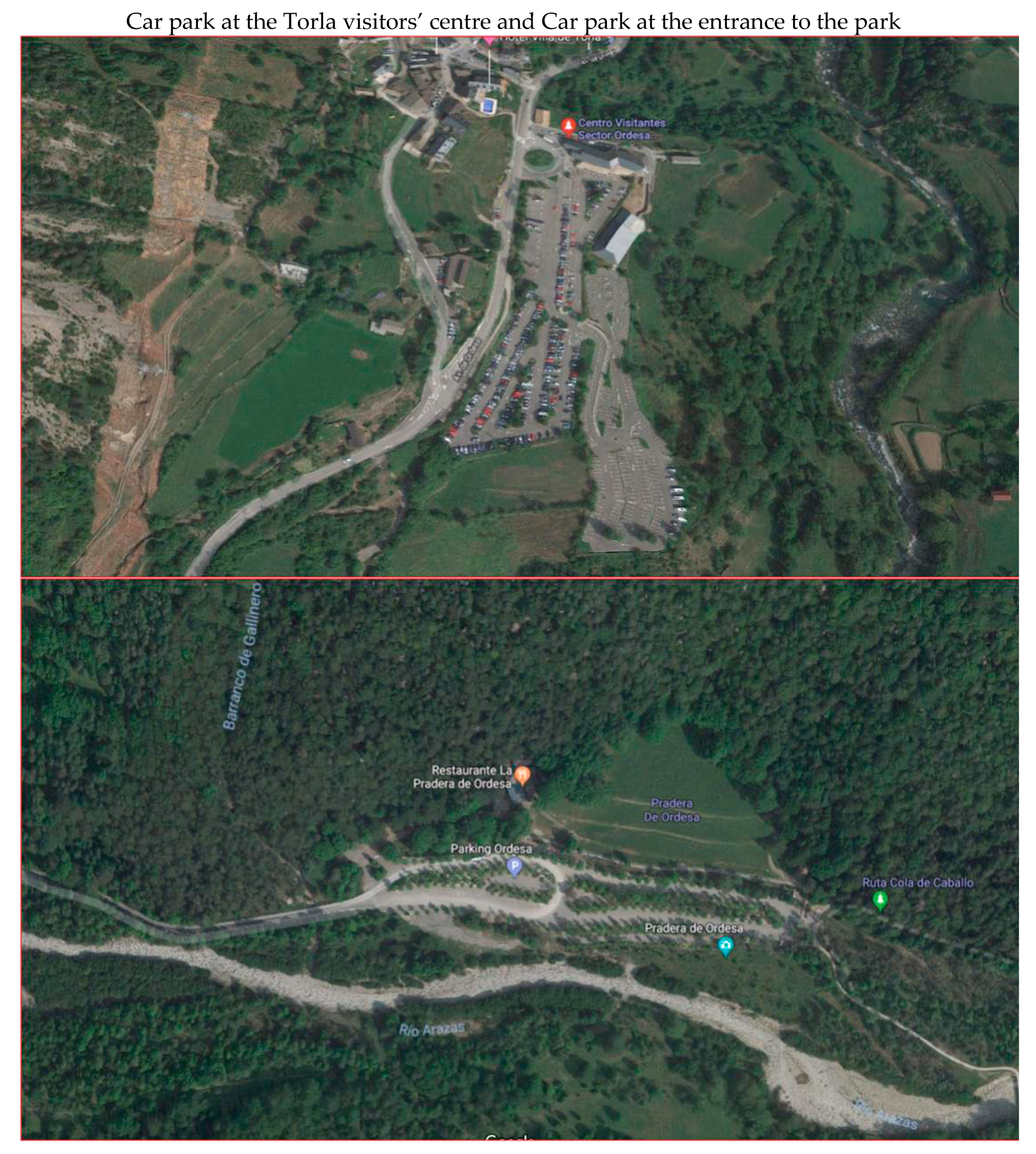
This structure gives the territory certain ecological-forest value on a regional level, particularly with regard to the landscape. It has a large influx of tourists, with more than 600,000, annual visitors 669, and this has given rise to many problems in the state of conservation of the park and in the safety of 670 visitors.
The Ministry of Environment set up the Tourist Access Plan in 1998 to reduce the impact of vehicles. Regarding the administration and management of the environment, the attitude can be described as very respectful towards these values. Thus, a parking lot has been built in Torla, with a capacity for 386 cars and 17 coaches, enabling buses to access Ordesa Valley.
4.1. The Response to Alternative Scenarios
The main contribution of the diagnosis by factors is methodological in accordance with the importance of the role that each of these components has in the process of development.
Three actions should be carried out: (1) Define the territorial use strategies, occupation and management of urban and rural land. (2) Design and adopt management instruments and procedures to regulate the actions of different sectors that affect the structure of the territory. (3) The definition of programs and projects that specify these objectives, ensuring that the foreseen actions are carried out as few planning proposals are implemented within the proposed period of time.
A decision support system on an individual case basis may suggest alternatives and provide decision makers with expert knowledge regarding control and concerns in land management choices to protect resources. Decision-makers can delineate site-specific and restrictive practices, develop sustainable strategies and provide support to property owners through conservation techniques and ecologically responsible farming [
35]. In addition, we are talking about processes that can take considerable time to reveal the agents that originate them or contribute to their development. Nonetheless, we consider this dual methodological approach to be a very valuable tool to understand the global process of transformation of the landscape. These processes of landscape transformation must be considered by territory managers, given their implications for biodiversity, water resources management, protection of soil quality or the prevention of forest fires. Changes in the functionality of the landscape emphasize the role of livestock activity and its relationship to the coexistence of other activities, whether these are related to tourism or to environmental conservation [
35].
The management and protection of these spaces produce a clash between two elements. On the one hand, the need to protect them from any impact that could irreversibly alter their environmental configuration. On the other, the right of society to access these spaces to carry out different activities (social and economic, cultural, recreational, research) and to know and enjoy such valuable resources. The popularization of national parks as a tourist destination, and easier access to them as a result of advances in means of transport and improved infrastructures, have given rise to overcrowding, which prevents the experience from being enjoyable, or even worse, may cause this protected natural environment to deteriorate [
36].
Problems detected are:
Traffic congestion derived from the accumulation of visitors.
Low level of economic integration. There are few administrative promotions and a monospecific economy based on farming.
Supply of tourist accommodation and complementary activities, lack of equipment and services, flow of visitors with high seasonality and low level of average daily expenditure, negative perception of the local population of hiking activities, (since it does not generate income, but it does conflicts: traffic, garbage, invasion of meadows, etc.).
Appearance of residential areas with second homes, isolated in the rural environment. The construction of these houses is discordant with building typologies.
4.2. Limitations
Using the scenarios described, areas of great value can be easily identified, and management control efforts can focus on these priority areas. Moreover, the present research is an effective source of awareness and empowerment for decision makers and landscape planners, through the knowledge of expected changes and their impacts. Thus, the generated scenarios have the advantage of serving as a basis for producing a decision support system for the region. In this sense, the study by Ford et al. (2012) [
37] is a basic reference. He focuses on the challenge represented by conserving national parks for future generations. All over the world, many are already experiencing degradation of their natural resources due to overcrowding.
The maintenance of natural resources must be ensured, and the quality of landscapes, flora, fauna, water and natural resources, human activities and management monitored as follows:
(a) Respect natural habitats and restore those that have undergone some alteration and favour the conservation and recovery of the cultural heritage of the park and its peripheral protection zone.
(b) Visits must be made compatible with the conservation of the park. It would be advisable to widen some roads, improve parking facilities, increase installations and conserve the built heritage of interest (
Figure 4).
(c) Constructions must be respected and stopped in areas that still retain their natural values, taking into account that the social, economic and community development of the park environment must be favoured.
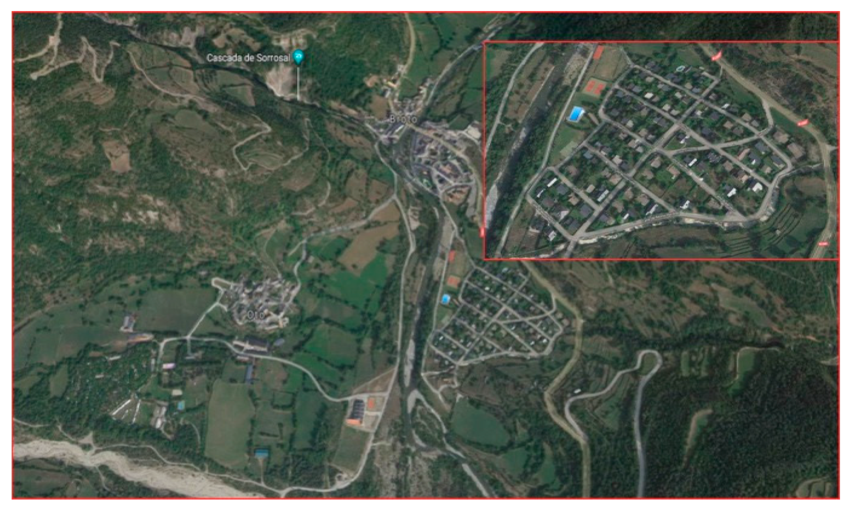
(d) In the consolidated area of municipalities, it would be desirable to adjust the conditions of urban development to facilitate harmonious and orderly development. It is necessary to rationalize the plot model and building within the plot, creating a balance between free space and built space, expanding the options of uses compatible with the main one. Isolated residential areas of second homes in the rural environment, such as the one in Formigal (
Figure 5), should be avoided as they do not blend with surrounding buildings.
5. Conclusions
The result is excellent because there have been small areas of change, as can be seen on the land use maps, and expansive activities have been limited. Land use is where the most effective and beneficial (or harmful) impacts can be seen in ecosystem services (support, provisioning, regulation, cultural services).
However, links between local, regional and national plans are limited and planning processes and territorial planning are highly politicised, focused on the short term (when a national or local government is in power), which hinders the possibility of continuity or following up valuable actions that will lead to sustainability.
In critical times for the relationship between the environment and society, when issues such as climate change or the risk of natural events, amongst others, are discussed on a daily basis, it is essential to identify fields of research and major action that will enable many of the observed negative tendencies to be improved and reversed. Territorial planning is one of these fields, as it contemplates instruments which, when applied at different scales, can have a positive effect on land in the short, medium and long term. Its positive effect will be even greater if the environmental component also takes into consideration ecosystem services in Ordesa park, thus bringing the land closer to the desired objectives of sustainability [
38].
This strategy also highlights the difficulties that exist for the approval of these instruments (red tape, multiple institutions involved, the need for public consultation, amongst others) and how this finally translates to a lack of information on the state of ecosystems. This method makes things easier and enables the identification of the social and economic limits and needs of each territory so that the necessary measures are implemented to guarantee sustainable use of biodiversity, natural resources in general and the associated ecosystem services [
39].
The Monte Perdido Massif (3355 m) dominates its orography, with the tops of the Tres Sorores, from where the valleys of Ordesa, Pineta, Añisclo and Escuaín extend. A landscape of great contrasts: the extreme aridity of the highlands, where rain and thaw water seeps through cracks and sinks, contrasts with the green valleys, covered by forests and meadows, where the water forms waterfalls and crosses canyons and ravines. The need to protect the integrity of the gea, fauna, flora, waters, atmosphere and, ultimately, the set of ecosystems of the mountain range of Monte Perdido, led to the extension of the original National Park to the current 15,608 hectares. This park had undergone few changes in land use between 2000 and 2018.
The distribution of vegetation manifests the climatic environment but also integrates the action of the passage of man. The entire territory has great forest and plant value, depending on its diversity and the quality of the environment. There are numerous beech forests.
In general, it presents a mosaic of ecosystems where there is a great floristic and fauna diversity (combination of glacial and karstic modelling, canyons and valleys, and the variability of climatic altitude and orientations existing throughout the Park). Therefore, it can be said that it constitutes a landscape of true contrasts:
Extreme dryness of the highlands.
Green valleys, covered with forests and meadows crossed by water in the form of waterfalls.
Diversity of plant formations.
The majority of the soil of the National Park is limestone, there is significant degradation or destruction of the soils, motivated by the following causes: weathering, erosion, transport and sedimentation. In addition, it is exacerbated by the constant rain or snow, which significantly affects the development of living beings, especially plants and, to a lesser extent, the fauna existing in the area.
Anthropic elements discordant with the landscape also reduce environmental quality by eliminating the natural elements that have been replaced by their new location, although the nuclei of the environment retain their stone buildings and historical centres.
We have analysed the situation in this territory because the NPMP has been followed without any sense, giving rise to a considerable number of problems. This method is applicable to other different Management Plans (MP) and other territories, both rural and urban. These plans analyse the different factors very well but are not systematized because they are often unattainable. As a result, many proposals have not been carried out. To address these problems, the new and innovative method of factor equation—the systematizing method—which explains how to follow these MPs and where to act in the first place, is applied.
The cause of some problems is neither legislation nor plans, but their interpretation. With this method, everyone has to study the same factors, which leads to a general opinion about the territory and the order of priority of actions. In this way, plans would be implemented much more efficiently until the result of the equation progressively approached zero (excellent). To do this, natural resources must be maintained and natural habitats respected.
This method gives a unique vision that does not depend on the specialist who applies it, since this vision is the result of systematizing all factors and, therefore, broad quartiles have been used so that the opinions of different experts have the same final result. Despite depending on specialists, the systematization of a result is easily interpretable. Not all factors can be covered at the same time and this causes many discussions when applying plans. The equation factor avoids this situation, indicating where to act first and which subsequent actions need to be taken.


