Article

Multi-Criteria Decision Analysis for the Land Evaluation of Potential Agricultural Land Use Types in a Hilly Area of Central Vietnam

1
Faculty of Geoscience and Geography, Göttingen University, 37077 Göttingen, Germany
2
Cartography, GIS and Remote Sensing Department, Göttingen University, 37077 Göttingen, Germany
3
Faculty of Land Resources and Agricultural Environment, University of Agriculture and Forestry, Hue University, Hue 0234, Vietnam
*
Author to whom correspondence should be addressed.
Submission received: 20 May 2019 / Revised: 29 May 2019 / Accepted: 31 May 2019 / Published: 3 June 2019

Abstract

:
Land evaluation is a process that is aimed at the sustainable development of agricultural production in rural areas, especially in developing countries. Therefore, land evaluation involves many aspects of natural conditions, economic, and social issues. This research was conducted in a hilly region of Central Vietnam to assess the land suitability of potential agricultural land use types that are based on scientific and local knowledge. In the frame of this research, Participatory Rural Appraisal (PRA); Analytical Hierarchy Analysis (AHP); Geographic Information System (GIS); and, scoring based scientific literature and local knowledge were applied for Multi-Criteria Decision Analysis (MCDA) for land use evaluation. The results of the PRA survey reveal that five plants offer great agricultural potential in the research area, namely rice, cassava, acacia, banana, and rubber. The land suitability of each plant type varies, depending on physical conditions as well as economic and social aspects. Acacia and cassava represent the most suitable plant types in the research area. Recommendations regarding agricultural land use planning in the A Luoi district are brought forward based on the land evaluation results. The combination of scientific and local knowledge in land assessment based on GIS technology, AHP, and PRA methods is a promising approach for land evaluation.

Graphical Abstract

1. Introduction

Today’s world population of 7.5 billion is projected to rise to 9.7 billion until 2050 [1]. Demographic developments, changing consumption patterns, and climate change are expected to reinforce the pressure on land and to increase the risk of food insecurity, especially in developing countries [2]. While the United Nations, with the second Sustainable Development Goal (SDG), strives to end all forms of hunger and malnutrition until 2030, to date, 793 million people still suffer from undernourishment [3]. The goal of the United Nations can only be achieved if growth agricultural production exceeds population growth through a sustainable intensification of existing, but limited, agricultural land [2]. Meanwhile, land resources are central to agricultural production and inseparably connected with food security [2]. Therefore, research regarding land resources should be carried out in a comprehensive way when considering the physical as well as socio-economic factors [4]. On the regional scale, the active participation of stakeholders can lead to a better and informed decision making process [5].
Vietnam is an agricultural country in Southeast Asia that is characterized by population pressure and land scarcity [6]. In 2016, 64% of the Vietnamese population resided in rural regions and 42% of the total labor force worked in the agricultural sector [7]. Therefore, the effective management of land resources for agricultural production in Vietnam is an essential requirement for food security and sustainable rural development. Despite the area of agricultural land expanding from 22% in 2005 to 39% in 2016, the productivity and the value of agricultural production in Vietnam still remains lower in comparison to other countries of the region, such as Thailand and China [7]. The inappropriate use of agricultural land is a major constraint to agricultural production in Vietnam [8].
Land evaluation is a process for predicting the land’s suitability for a specific land use type (LUT) in a given area. Land evaluation provides a rational basis for land use planning [9], especially in developing countries, where an increase of arable land, which is often limited by negative effects of land degradation and environmental issues [10]. Distinct methods and models have been applied for land evaluation, such as Linear Combination, Simple limitation, fuzzy-logic modelling, the use of Artificial Neural Networks, and the Analytical Hierarchy Process (AHP) [11,12,13,14,15,16]. Despite some limitations, the AHP is still the most commonly applied method for land evaluation, especially on a small scale [17,18,19].
Determining the requirements for a LUT and scoring the suitability level has significant impact on land evaluation results [20]. The Food and Agriculture Organization of the United Nations (FAO) (1996) [21] suggested that climate, soil, and landform are the necessary requirements for land evaluation from an ecological perspective. Sys et al. (1993) [22] provided the reference values for physical crop requirements for fifty crop types that are commonly cultivated in the tropical and sub-tropical regions. These values have been applied by many researchers for land suitability evaluation [23,24,25,26,27]. However, the crop requirements that were provided by Sys et al. (1993) [22] are not detailed enough for smaller areas with specific characteristics.. Therefore, most of the researchers modified the original crop requirements document to adapt to local conditions, experiences, and data availability [28,29]. Local knowledge in land evaluation is very significant for land use decision-making and land management in rural areas [30]. The integrated method of scientific and local knowledge in land evaluation can lead to improved sustainable agricultural production [31]. A combination of biophysical surveying, spatial modeling, and participatory methods are needed for effective land evaluation, according to the FAO (2007) [20].
Research on land evaluation requires a large amount of spatial data, which Geographical Information Systems (GIS) are capable of easily and efficiently handling. Therefore, many researchers have used GIS for land evaluation [32,33,34], a process, which enables the integration of multiple attributes and different criteria that are involved in decision-making. Land evaluation can be seen as a multi-criteria decision analysis (MCDA) process [35], which, when combined with GIS, can become a powerful approach for land evaluation [34,36]. GIS techniques play an indispensable role in spatial analysis, whereas MCDA provides a rich collection of tools for structuring decision problems, as well as evaluating and prioritizing alternative decisions [34].
This paper describes the integration of GIS and AHP methods that are based on scientific and local knowledge to determine the land suitability for some potential agricultural LUTs in a hilly district of Central Vietnam.

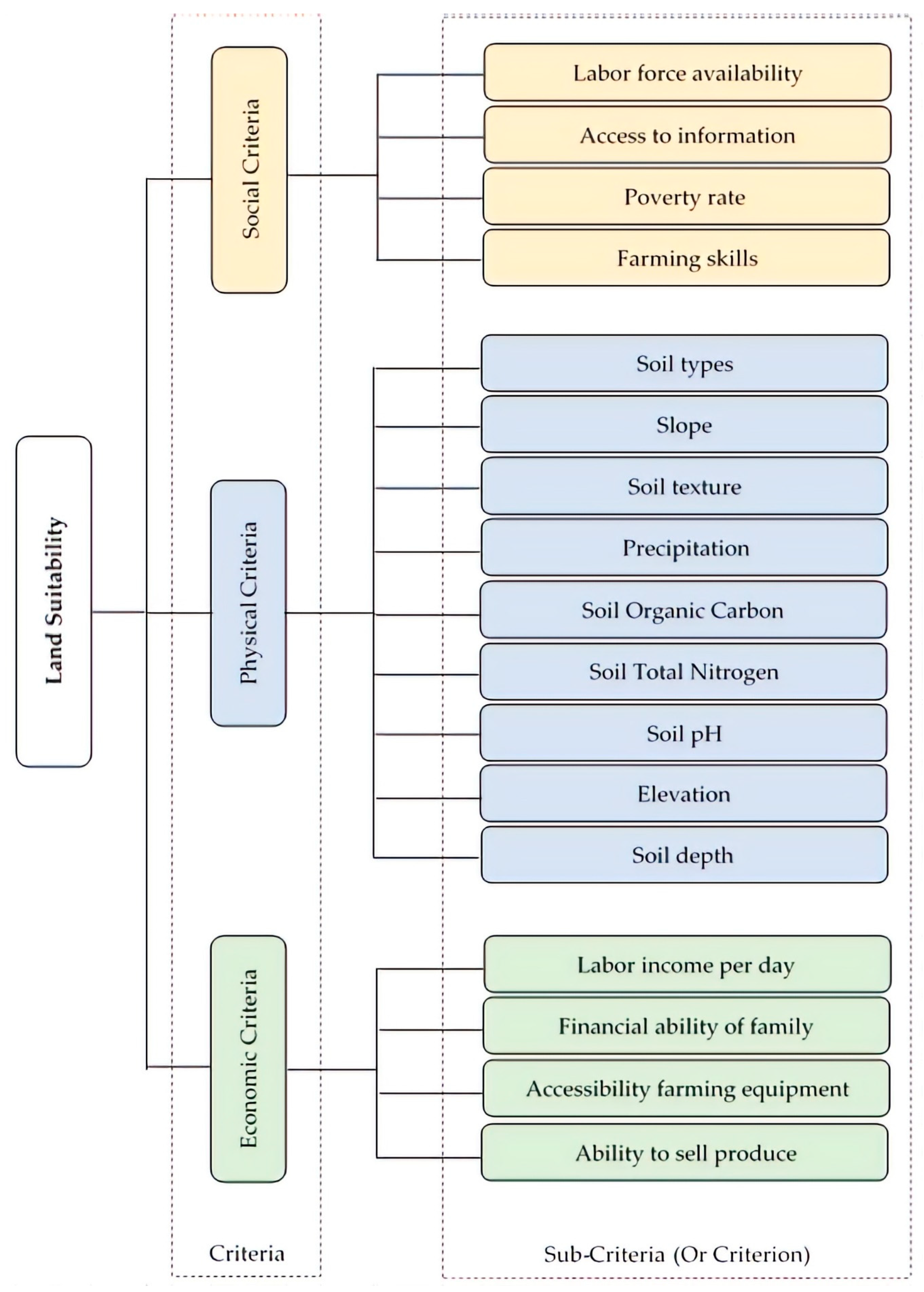
2. Materials and Methods

2.1. Reseach Area

The study area “A Luoi district” is located between 107° E to 107°30′ E and 16° N to 16°30′ N and it is situated around 60 km west of Hue city, in Central Vietnam (Figure 1). The climate at the research site shows tropical monsoon characteristics with an annual rainy season from September to December. The average yearly precipitation amounts to 3180 mm, according to statistics from 2005 to 2015. The average temperature reaches its maximum in May and its minimum in January at 25 °C and 17 °C, respectively [37]. The research site exhibits a low mountainous topography, with elevations ranging from 60 m to 1760 m above sea level, and decreasing from west to east. The slope in the area is complex and steep, with an average of more than 20 degrees. According to the international soil classification system [38], there are four soil types within the research area, including acrisols (ferralic) (75%), acrisols (arenic) (14%), acrisols (humic) (6%), and acrisols (hyperdystric) (5%) [39].
A Luoi district has an area of 122,415 hectares (ha), of which 60,105 ha (49%) are covered by protected forests, 57,492 ha (47%) are agricultural land (including production forests), 2318 ha (2%) represent water bodies, and 2500 ha (2%) are residential and infrastructural areas [40].
Four ethnic minority groups are living in the research area, namely the Ta Oi, Co Tu, Van Kieu, and Pa Ko, accounting for 75% of the total population. The majority Kinh people occupy 25%. In 2015, the total population was 47,115 inhabitants with 12,405 households. The households living below the poverty line occupied 37% of the total households. The poverty line was defined as a monthly income per person less than 26 Euro [37].
Agricultural production and collection of forest products are the main livelihoods of the majority of local people. Agricultural labor accounts for 75% of the entire labor force [37]. Acacia, rice, rubber, cassava, and banana are the five main agricultural crops. In addition, there are a number of minor crops, such as corn, peanuts, and vegetables, which occupy a rather small area and do not have a significant impact on local people’s livelihoods [37]. The lack of basic resources, such as financing options and modern agricultural knowledge, is one of the main obstacles to sustainable livelihood development, especially in agricultural cultivation [14].

2.2. Material

Input information plays an essential role for land evaluation. For each LUT, different values and ranges of criteria exist, defining the different suitability levels. For the selection of criteria, the available data, the cultivation history, and both local and worldwide knowledge need to be considered [41]. The available datasets for land evaluation included geospatial as well as descriptive information. In total, six teen land characteristics were chosen as the input layers for the land evaluation process listed in Table 1.

2.3. Methods

2.3.1. Participatory Rural Appraisal (PRA)

The PRA method enables the capturing of opinions from farmers and other key actors in agricultural and rural research [45]. In our study, the PRA method was used to select the potential crops as well as the assessment of physical and socio-economic aspects in respect to land suitability evaluation. The group discussion was implemented in eleven focus groups, with three to five people per group. The groups consisted of members of the Agricultural Department of the commune or district, the Natural Resources and Environment Department, the Labor and Social Affairs Department, and the Industry and Commerce Department of A Luoi district. Additionally, members of the district or commune committees, academics from Hue University, and farmers of the region participated in the discussions. Moreover, individual interviews were conducted with soil scientists and agronomy experts for the land evaluation regarding physical criteria (Table 2).

2.3.2. Criteria Weighting According to Analytical Hierarchy Process (AHP)

The AHP theory that was developed by Thomas L. Saaty (1987) [46] is a MCDA approach. In scientific research on GIS-based land suitability evaluation, the approach is frequently applied for criteria weighting [15,47,48,49,50]. The AHP is a method for deriving a priority scale through pairwise comparison of attributes based on participant judgments [51]. The weighting of criteria through the AHP method was implemented, as follows:
(1) Selection of criteria and setting-up a hierarchy structure.
The hierarchical structure is composed of three levels with the overarching goal of determining the land suitability index for each LUT (Figure 2). The second and third levels show the criteria and sub-criteria influencing the decision. Each sub-criteria has different attributes describing specific characteristics, which have influence on the scoring algorithm for various LUTs. These characteristics need to have substantial influence on the productivity, feasibility, or sustainability of the agricultural land use [52]. In addition, critical values and a notable variation of criterion must be prevalent within the study area [53]. The final set of sub-criteria were selected and categorized with reference to the relevant literature [48,54,55,56,57], local expert knowledge, as well as local cropping guidelines that were provided by Nguyen et al. (2015) [52].
(2) Construction of pairwise comparison matrices according to the relative importance of each criterion (or sub-criterion).
The comparison matrices were derived from the experts’ judgments and constructed, as described by Mu and Perevra-Rojas (2017) [58]. A numerical scale that was developed by Saaty (2008) [51] was used to compare these criteria (or sub-criteria), as shown in Table 3.
The geometric mean was applied to synthesize group judgments, as it represents the only mathematically correct way to aggregate reciprocal judgments [59,60]. The Original Matrix (A), which compares the priorities of all criteria against each other, was constructed.
A =   ( 1 C 12 C 1 i C 1 j C 1 n C 21 1 C 2 i C 2 j C 2 n C i 1 C i 2 1 C i j C i n C j 1 C j 2 C j i 1 C j n C n 1 C n 2 C n i C n j 1 )
C i j =   ( k = 1 m a i j k ) 1 m
where:
  • C i j is important level of criterion i as compared to criterion j
  • a i j k is important level of criterion i as compared to criterion j according to expert k t h
  • m is number of expert involves to discussion
Subsequently, the Normalized Matrix (B) is calculated from the A as Lee et al. (2012) [61].
B = ( c ¯ 11 c ¯ 12 c ¯ 1 i c ¯ 1 j c ¯ 1 n c ¯ 21 c ¯ 22 c ¯ 2 i c ¯ 2 j c ¯ 2 n c ¯ i 1 c ¯ i 2 c ¯ i i c ¯ i j c ¯ i n c ¯ j 1 c ¯ j 2 c ¯ j i c ¯ j j c ¯ j n c ¯ n 1 c ¯ n 2 c ¯ n i c ¯ n j c ¯ n n )
C ¯ i j =   C i j i = 1 n C i j
where:
  • C ¯ i j is normalized value of C i j
  • i = 1 n C i j is sum of C i j by column j from matrix A
  • n is number of compared criteria
From the matrix B, the criteria weights can be derived, as follows:
w i =   j = 1 n C ¯ i j n
W =   ( w 1 w 2 w i w j w n )  
where:
  • w i is the weight of criterion i
  • j = 1 n C ¯ i j is sum of C i j by row j from matrix B
(3) Validating the consistency of the final matrix of judgments.
A certain degree of inconsistency can be expected for criteria weightings based on group judgments. The consistency ratio enables the validation of the participant’s answers by giving some indication on the compatibility and rationality between compared criteria. The consistency ratio was calculated, as suggested by Mu and Perevra-Rojas (2017) [58] and Saaty (1987) [46].
C R = C I R I
where:
  • C R is Consistency Ratio
  • R I is Random Index has already been provides by Saaty (1987) [46] as Table 4.
C I is Consistency Index (CI) is then obtained by calculating:
C I =   λ m a x n n 1
λ m a x =   j = 1 n w i C i j w i n
According to Saaty (1987) [46], an inconsistency of 10% is acceptable. Hence, the weights of a judgment matrix characterized by a CR ≤ 0.1 can be used for further analysis.

2.3.3. Deriving Scores for Criteria Levels

The level of each criterion ranges between the minimum and maximum values in the region, which results in a distinct LUT performance, depending on the respective LUT. Therefore, the scores need to be assigned indicating the suitability level of each attribute of each criterion for a given land use type [9].
Many authors [55] refer to the land evaluation guidebook by Sys et al. (1993) [22], which summarizes crop requirements for the tropics and sub-tropics. However, this guideline shows significant shortcomings, as it does not provide information regarding some essential criteria (soil total nitrogen, elevation, soil type), and additionally does not contain reference values for acacia requirements. Moreover, no information on economic or social criteria are given by Sys et al. (1993) [22], which are, for the growth of some crops, equally important as the physical characteristics of an area. Due to these reasons, we introduced an attribute scoring based on the opinions of local stakeholders that were gathered from the PRA survey, in addition to the common scoring approach that was derived from Sys et al. (1993) [22]. We combined the scores according to Sys et al. (1993) [22], where possible, with scores that were derived from the PRA survey and assigned a weight of 50% to each scoring approach in the final suitability map. In those cases, in which the literature does not provide any information, the PRA scores were fully applied for further analysis. A scale from three to nine was used to reflect the increment from a very unsuitable condition to very suitability conditions for a particular LUT (Table 5).

2.3.4. Suitability Classification

The suitability can be measured with the suitability index (Si) (Table 6), which represents a function of the weight and the score of each level of criterion regarding certain LUT. According to Huynh (2008) [14], the suitability index for one land mapping unit (LMU) and one LUT is described, as follows:
S i = i = 1 n X ¯ i w i
X ¯ i =   v = 1 u X i v u
where:
  • Si = suitability index for a particular LMU and LUT
  • X ¯ i = Score of i t h criterion
As a result of the PRA survey, a threshold of 5.0, which is equivalent to the level N according to Sys et al. (1993) [22], is used as a threshold for the areas that are unsuitable for the evaluated LUTs, which will be excluded from further analysis in our research.

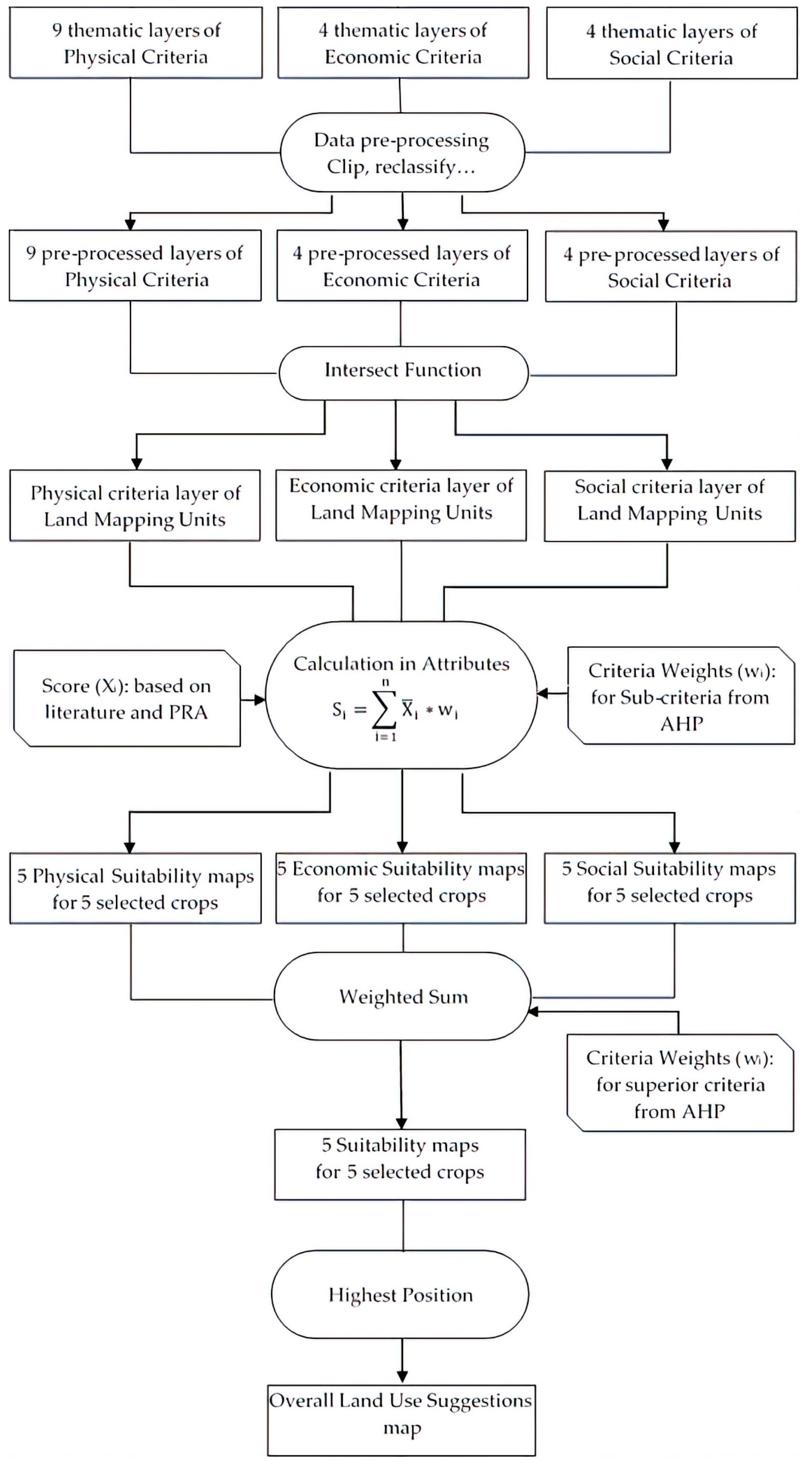
2.3.5. GIS Based Land Suitability Evaluation

Seventeen thematic layers were created corresponding to the seventeen selected criteria for the land evaluation process. These maps were classified based on the PRA survey and literature. Afterwards, an intersection of all the layers was carried out to receive the land mapping units. The maps of land mapping units form the basis for analyzing the physical, economic, and social suitability of each land unit with respect to certain crop types. The calculation of suitability indices was performed using the attribute table of the vector layers, as suggested by Huynh (2008) [14]. The output of the suitability mapping will contain fifteen maps for all five crops showing their suitability with respect to the physical, economic, or social criteria. To receive the overall suitability, the three criteria-maps need to be overlaid for each crop. The weighted sum is used to create overall suitability maps for each crop. From the suitability maps of each kind of crop, the highest position tool was applied to analyze the most suitable land use for a particular land unit (Figure 3).

3. Results

3.1. Selected Crops for Land Suitability Evaluation

The group discussions led to the assumption that seven main crops are currently being cultivated in A Luoi district: acacia (Acacia spp.), cassava (Manihot esculenta), rice (Oryza sativa), rubber (Hevea brasiliensis), banana (Musa spp.), coffee (Coffea canephora), and different vegetables.
The pairwise comparison for the selection of land use type was conducted in-group discussions with 25 participants from different backgrounds. The result (Table 7) indicates that acacia, cassava, rice, rubber, and banana represent the most promising LUTs, and will hence be evaluated in this research.

3.2. Characteristics of Physical, Economic and social LMUs

The LMUs map contained 987 land units for different physical, economic, and social criteria.

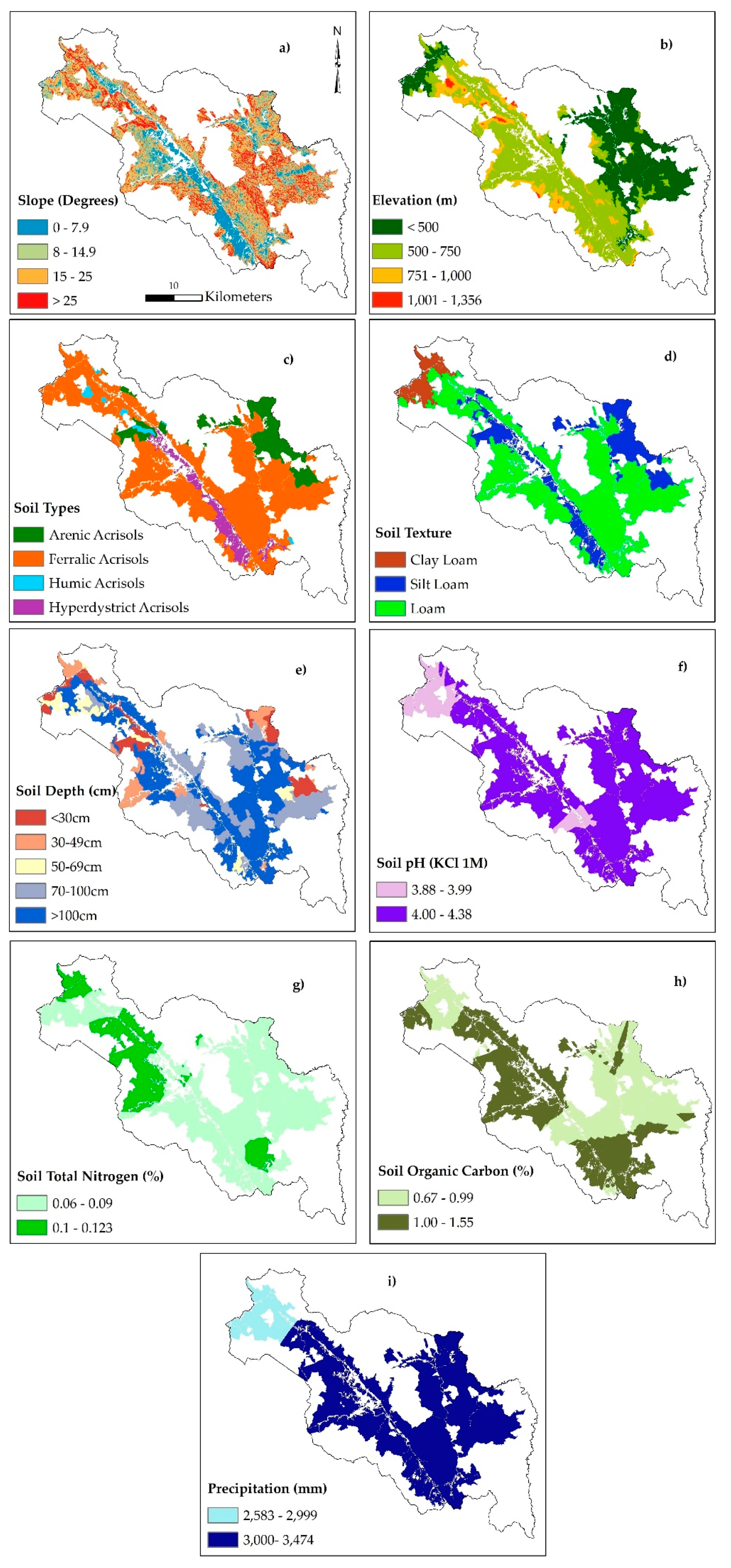
3.2.1. Layers of Physical Characteristics

There are nine physical characteristics layers present in Figure 4.
* Slope: 13,500 hectares of the total study area, mainly located in the center of the valley, show moderate slope levels between 0 and 7.9 degrees. The slope level rises with increasing distance from the valley and the highest slope levels of more than 25 degrees are found along the mountainsides in the western part of the district.
* Elevation: The center of the valley and the eastern part of the district exhibit a low elevation level, with approximately 2000 hectares underneath the elevation thresholds of 500 m. Nearly 30,000 hectares of the studied area show elevation levels between 501 and 750 m. The remaining parts, especially in the west, mostly exceed an elevation of 1000 m above sea level.
* Soil type: The acrisol only represents the prevalent reference soil group within the research area. Acrisols (ferralic) cover the largest parts with 43,500 hectares and are scattered all over the district. Acrisols (arenic) occupy the second largest area with a size of 8700 hectares in the central east of the district. Acrisols (hyperdystric) can be exclusively found in the valley intersecting the district and Acrisols (humic) exclusively occur in small patches, mainly in the north-west of the district.
* Soil texture: Pure loam occupies the largest extent with an overall area of around 40,400 hectares. Clay loam is present on only 3500 hectares in the north and silt loam occupies 13,600 hectares in the valley and in the eastern parts of the district.
* Soil depth: A soil depth of more than 100 cm is prevalent on nearly 30,000 hectares, followed by a soil depth of 70–100 cm occupying about 15,000 hectares. Soil depths of less than 70 cm can be found on only 25% of the evaluated area.
* Soil pH: The soil in the entire area can be referred to as acidic. The soil pH ranges from 3.9 to 4.4. The soil pH of the central district is higher than in the remaining regions.
* Soil total nitrogen: The soil total nitrogen contents in the region vary between 0.06 and 0.12 percent of the soil weight. The lowest soil nitrogen levels can be found in the eastern region of the district, while higher ones can be measured in the central west, in the valley, as well as in the southern part.
* Soil organic carbon: The average soil organic carbon contents in the region range between 0.67 and 1.55% of the soil weight. Similar to soil total nitrogen contents, soil organic carbon shows the highest levels in the valley and in the southern part of the district, while the soil organic carbon contents in the eastern part remain low.
* Precipitation: Due to the high mountains in the west, the precipitation in A Luoi district is rather high, varying between 2500 mm and 3500 mm. Rainfall levels reach their maximum in the center of the district.

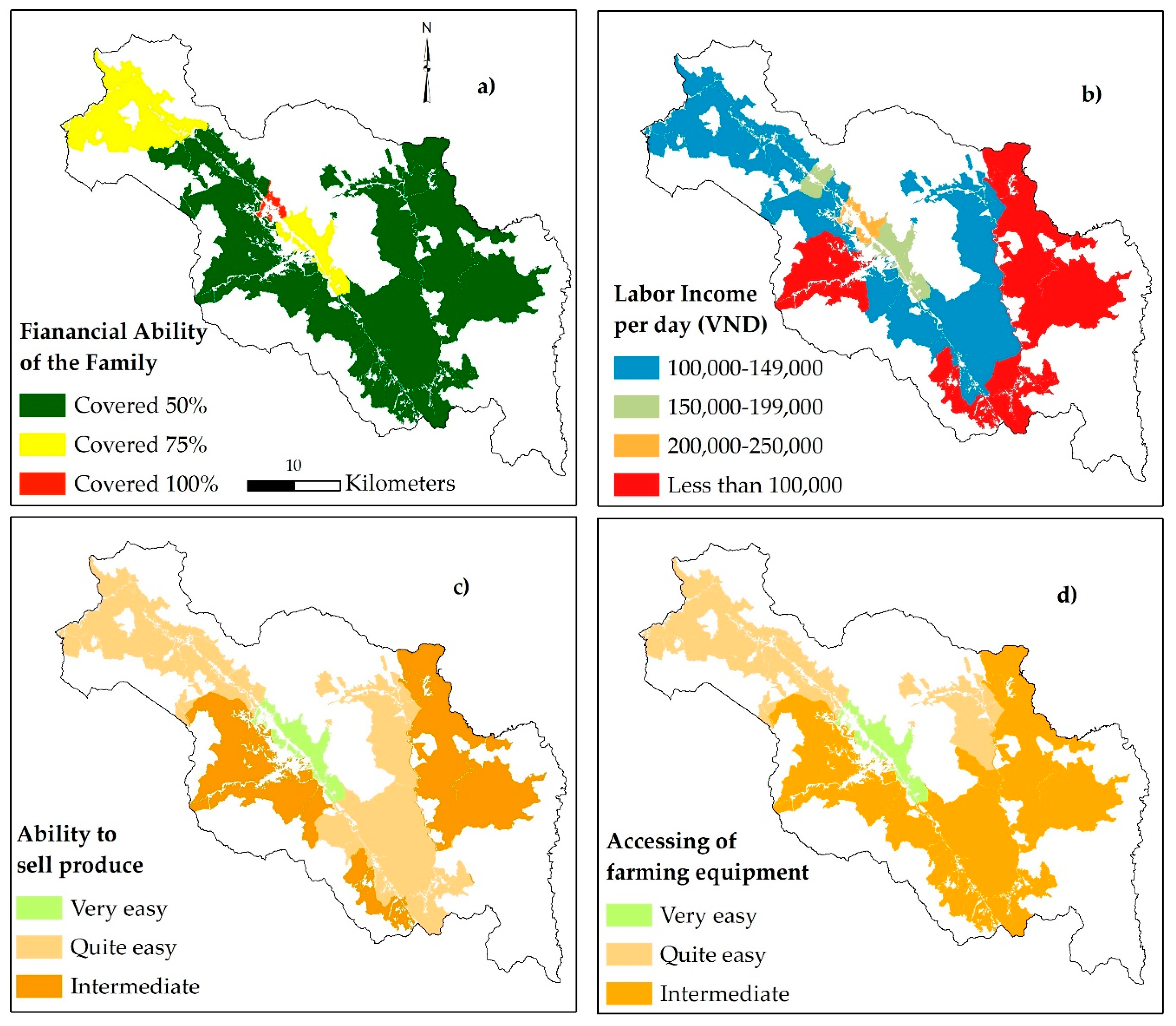
3.2.2. Layers of Economic Characteristics

There are four economic characteristic of economic layers as show in Figure 5.
* Financial ability of the family: This criterion refers to the financial ability of the family to invest in agricultural cultivation. The households in the center of the district are able to cover larger amounts of financial requirements for cropping by their own means.
* Labor income per day: The criterion describes the daily average income of a farmer who spends one day of work on the respective crop. The labor income per day plays an essential role in commercial LUTs, such as rubber, acacia, and banana. The income of people, who live in the communes that are located in the center of the district and in the lower terrain area, is higher than the labor income of other communes, as these offer other income opportunities. On average, their income amounts to more than 150,000 VND per day. While the labor income in the north was estimated between 100,000 and 149,000 VND per day on average, in the mountainous communes along the southern and eastern district border, labor income falls below the line of 100,000 VND.
* Ability to sell produce: The communes along the main road (national road) can quite easily sell their products. For the mountainous communes, located far away from the main roads, as well as the large rural commune of Huong Nguyen, the selling of produce is more challenging.
* Accessibility of farming equipment: This criterion describes the ability of a farm family to purchase farming equipment. Again, the communes located in favorable areas have better access to the inputs and agricultural machinery than other communes do.

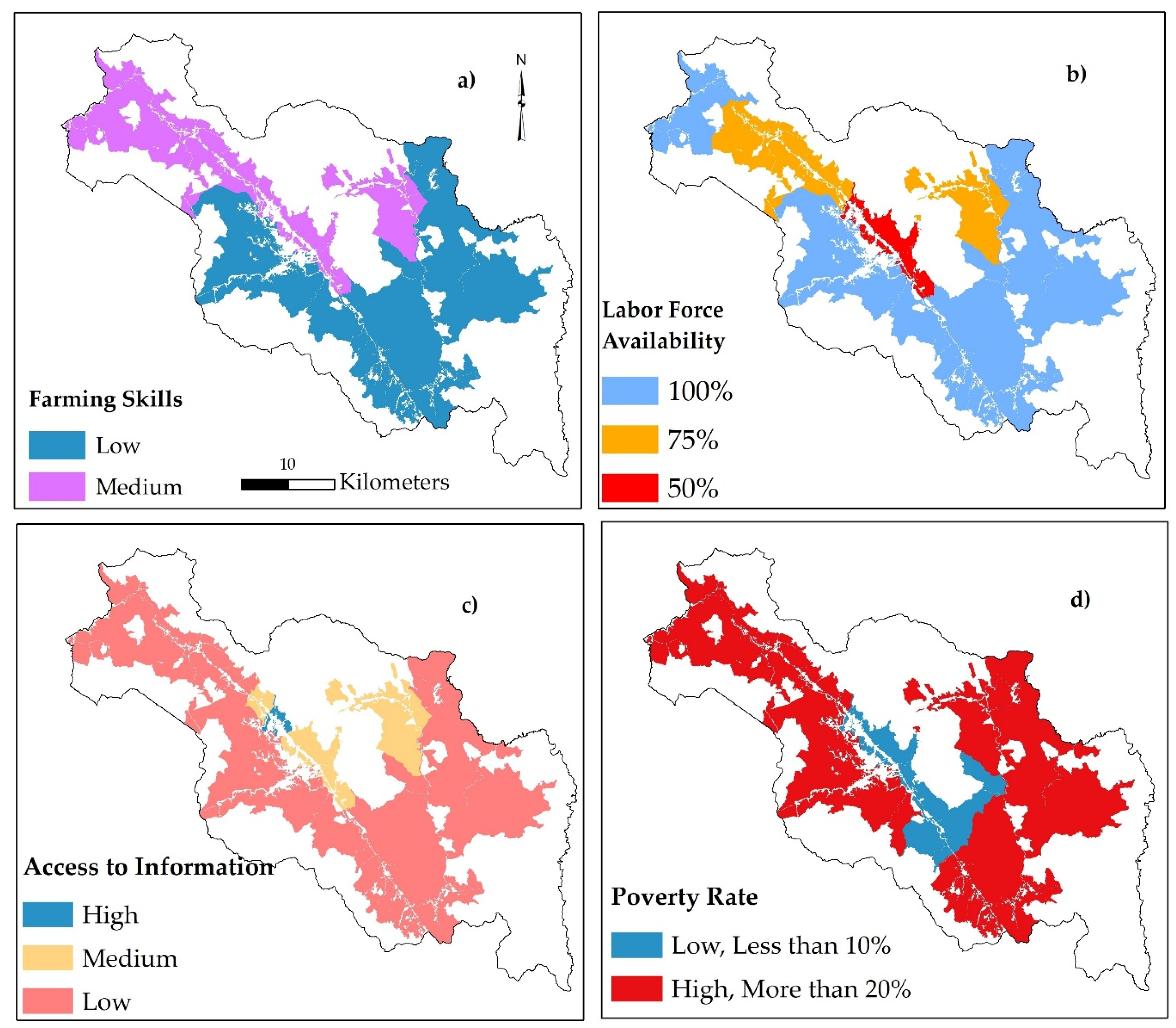
3.2.3. Layers of Social Characteristics

There are four social characteristics layers present in Figure 6.
* Farming skills: One of the most challenging issues of farmers in the A Luoi district is the level of farming skills. Farming skills are vital, especially for agricultural LUTs, like rubber and banana. In general, most local farmers practice agriculture based on their experiences.
* Labor force availability: This criterion refers to the potential agricultural labor force that each household in the commune can provide. The local people in the central area have other income opportunities apart from agriculture, as already described in the context of labor income per day. As a result, the labor force that is available for agricultural production is lower than in rural and mountainous communes.
* Access to information: The information regarding agricultural practices and technologies is crucial for agricultural production, especially for commercial LUTs. According to the experts, only the inhabitants of A Luoi Town, which is characterized by favorable infrastructural conditions, are, on average, highly informed regarding new developments in the sector. Other communes in the valley and around A Luoi Town, as well as Hong Ha commune, are assigned a medium level of information, while the mountainous communes show a low level of information accessibility.
* Poverty rate: The criterion estimates the share of commune’s inhabitants living below the poverty line, which is defined at 700,000 VND per month. Around 37% of all households in the A Luoi district live below the poverty line. A low poverty rate is assigned to the least rural communes, as A Luoi Town and the adjacent communes in the valley. A high population living below the defined poverty line characterizes the remaining regions.

3.3. Criteria Weights and Scores

The criteria weighting shows the differences in the importance level of each criterion (or sub-criterion) on the different LUTs (Table 8). In general, the economic aspects play an essential role in commercial LUTs, such as rubber, acacia, and banana. Hence, on the highest level of the hierarchy, the overall economic criterion was assigned a considerably higher priority for the commercial crops (all > 0.5) than for rice and cassava. As opposed to this, physical and social criteria seem to be more critical for rice and cassava LUTs than the economic criteria. Moreover, each sub-criterion has a different impact on the particular LUT. For example, with respect to physical conditions, soil quality criteria generally have a stronger influence than terrain criteria. Regarding economic criteria, the commercial agricultural LUTs (acacia, rubber, and banana) are mostly influenced by criteria that are associated with the market.
The scoring of the attribute of criteria (Table 9) is the assessment of the LUTs suitability with the particular attribute of each sub-criteria related to physical, economic, and social conditions. Regarding the criteria scoring, the attributes of all criteria were rated for each LUT with respect to the specific LUT requirements. For physical criteria, the scoring was carried out based on the PRA surveys as well as on literature that Sys et al. (1993) [22] provided. The result shows that the PRA scoring and literature scoring approach show similarities, but differ in their magnitude. Concerning physical criteria, low pH values, high levels of slope, as well as low soil fertility in the region are a limiting factor for all kinds of agricultural land use. On the contrary, the main soil texture attributes and precipitation levels are favorable regarding the majority of LUTs. With respect to economic criteria, low levels of economic criteria are assigned for most commercial LUTs. Regarding the prevailing social conditions within the study area, the differences between the commercial LUTs, except acacia, to the non-commercial LUTs can be observed. A low level of farming skills and information access, as well as a high poverty rate, in a more negative score for commercial crops. In general, the remaining LUTs are more resilient to unfavorable social circumstances.

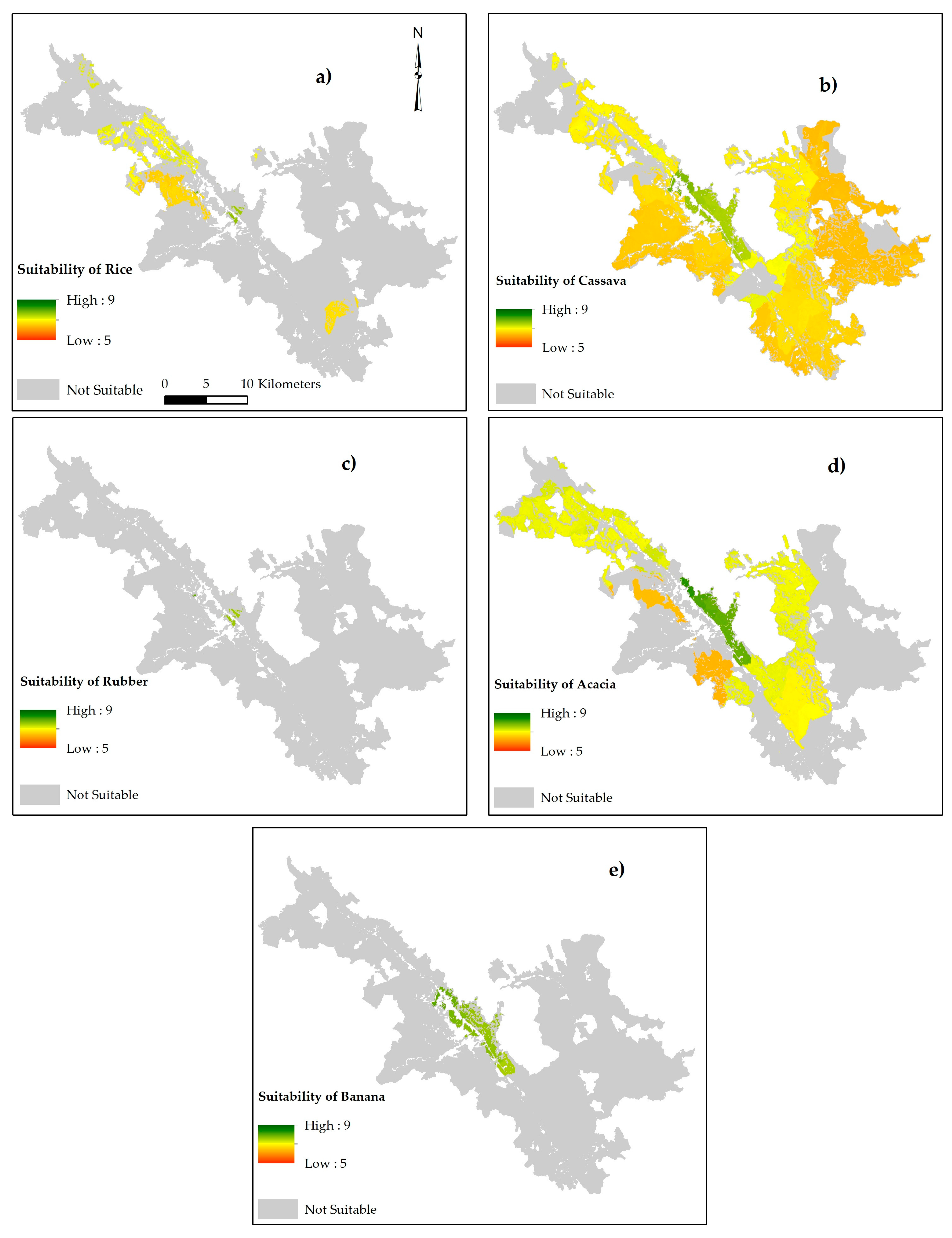
3.4. Land Suitability for Selected Land Use Type

3.4.1. Rice

4139 hectares of the study area are suitable for rice production, with a land suitability index of 6.41 for the least suitable and 7.88 for the most suitable areas. Most suitable areas for this kind of land use are located in the center of the valley and the north of the district. In the south, some potential areas with a comparably quite low suitability index exist around Huong Lam.

3.4.2. Cassava

Cassava represents a LUT of high potential in A Luoi district with 39,027 hectares of potential agricultural areas. The suitability index varies from 6.29 to 7.92. Within most land units, cassava cropping only faces slight limitations. Therefore, no significant unfavorable conditions concerning either the physical, economic, or social criteria exist. The central region represents the most suitable area, while the eastern and western parts only show low to medium suitability levels.

3.4.3. Acacia

Even though soil depth significantly limits the acacia LUT, this kind of tree still shows high potentials. In total, 21,082 hectares are suitable for acacia with suitability indices that range from 5.96 to 8.42. The areas with a high suitability index (more than 7.0) account for 17,500 hectares, which equal 83% of the entire suitable areas. The most suitable land units are located around A Luoi Town stretching out into the southern and northern direction of the valley. The communes along the western and eastern district border, on the contrary, were entirely evaluated as unsuitable for this LUT.

3.4.4. Banana

Banana is a commercial LUT, which became more popular in A Luoi district in recent years. The calculated suitability indices for banana vary between 7.5 and 8.07, with a mean of 7.70. Most of the suitable areas are located in the center of the district with the highest suitability in the northern and the lowest in the southern parts. In total, 1,584 hectares are suitable for banana cultivation.

3.4.5. Rubber

The area that is suitable for rubber cultivation is not significant, as it only amounts to 120 hectares in the center of the district. Suitability indices between 7.51 and 8.09 were assigned to this area.

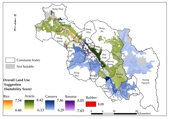
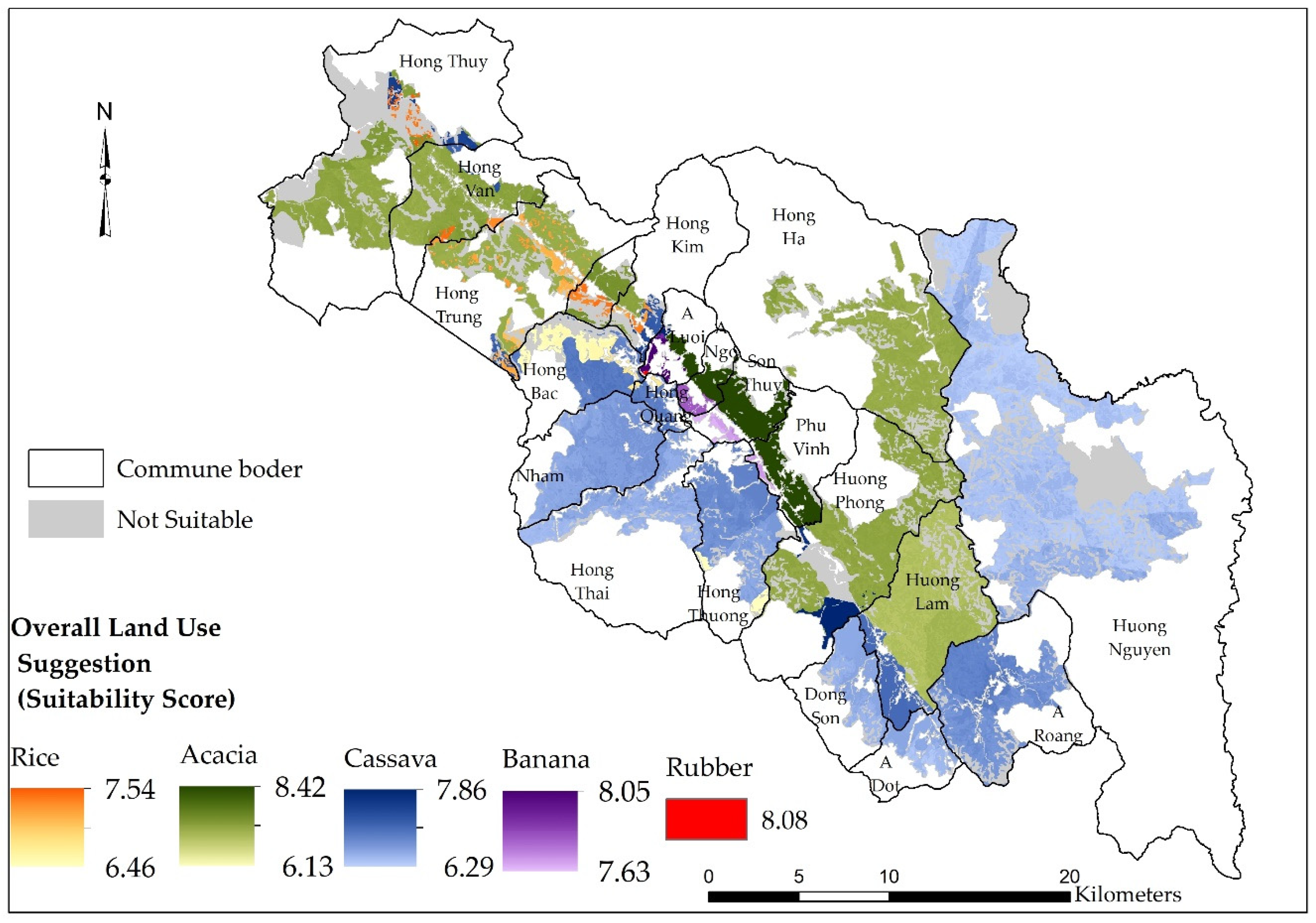
3.4.6. Overall Land Use Suggestions

The most suitable land use type was determined for each land unit. The results show that rice production could be carried out in the areas in the north-western communes, such as Hong Bac, Bac Son, Hong Trung, Hong Van, and Hong Thuy on of 1,388 hectares. The western, southern, and eastern parts are most the suitable for cassava cultivation with a large area of 23,835 hectares. The suitable areas for acacia account for 18,438 hectares, and they expand from the northern communes along the valley towards the southern and eastern parts of A Luoi district. The area for rubber cultivation type is small, with only five hectares in A Luoi Town. Small land units, summing up to the extent of 437 hectares in A Luoi Town and along the main road are suitable for banana LUT. Figure 7 presents the suitability map for each kind of LUT and Figure 8 presents the overall land use map for entire district.

4. Discussion

4.1. Land Suitability Evaluation Methodology

The implemented methodology of land suitability evaluation proved to be an appropriate and useful approach for the application in a hilly district of Vietnam. In the Vietnamese uplands, social and economic characteristics have a significant impact on agricultural land use [62]. The MCDA procedure allowed for the integration of physical, economic, and social criteria, as well as the involvement of local experts’ judgments. However, these judgments can be highly variable in space and time, which thus leads to a trade-off between local knowledge involvement and objectivity. Moreover, it has limitations of independence among criteria [63]. Zolekar & Bhagat (2015) [57] make use of correlation analysis to demarcate the most determining criteria for agricultural land use and to eliminate the interdependent ones, which would have been an adequate option to improve the data base.
The use of a Geographic Information System proved to be highly useful in the context of land suitability evaluation, as it facilitates the geographic assignment of criteria to land units. For physical criteria, random sampling and interpolation proved to be an adequate approach to represent the physical conditions in the area [42]. However, the Boolean approach still has limitations on the ability to express the transitional or continuous variation in geographical features [64]. To reduce this limitation, Fuzzy set theory [65] with partial membership function could be used as an appropriate solution [66,67]. With regard to the economic and social criteria, it must be noted that the community-wise assignment of characteristics leads to oversimplification, as socio-economic traits can differ considerably, even within communities. For a small-scale and more appropriate observation, a household survey on socio-economic factors regarding agricultural land use practices would be required. However, as stated by Yen et al. (2013) [62], a more complex approach to land suitability evaluation requires high quality data and sufficient resources to acquire such data.
This study indicates that the exclusive procurement of scoring values from Sys et al. (1993) [22] cannot draw a holistic picture of the local conditions. The land suitability evaluation that is based on the PRA survey differed considerably from this approach, particularly in the evaluation of the commercial crops rubber and banana. According to the guideline of Sys et al. (1993) [22], most agricultural land of A Luoi district would be unsuitable for crop production, due to soil being very acidic and the steep terrain. However, very diverse agricultural land use is taking place in the research area. This finding leads to the conclusion that site-specific knowledge regarding local characteristics cannot be captured by universally applicable literature. Therefore, this study suggests the integration of scientifically grounded literature on crop requirements and local knowledge in the form of a scoring through PRA methods.

4.2. Limiting Factors for Agricultural Production

Many environmental, economic, and social conditions of A Luoi district are unfavorable for agricultural production. Physical criteria, such as steep terrain, soil acidity, and low soil nitrogen are the main restrictions for agricultural cultivation, especially for commercial crops, like rubber and banana. Serious erosion rates, population pressure, and fallow cultivation have an additional negative effect on sustainable cultivation [68,69].
Unfavorable economic conditions are mainly prevalent in the remote areas of the study area due to infrastructural and physical limitations [70], which particularly affect the production of commercial crops. An essential requirement for this kind of land use is the long-term financial ability. This requires significant investments during the early period of crop production, with expected benefits at a later stage [71]. In the last years of the life span, the productivity and quality of agricultural products will significantly reduce, leading to economic risks for the local people [72]. Hence, from an economic viewpoint, the accessible and central municipalities are the most suitable for agricultural land use.
The evaluated crops are most suitable in the lowland where lowest poverty rates, sufficient access to information, and a higher level of farming skills are prevalent. These social conditions are vital for the production of rubber and banana. For instance, the plantation of rubber trees, the harvest of latex, and the manufacturing of a transportable rubber product demands a considerable degree of technological knowledge [73,74]. In comparison to cassava and upland rice, the knowledge base among farmers regarding new commercial crops is still limited [72].

4.3. Future Perspective on Agriculture in A Luoi district

Significant changes in investment, household income, and policies have occurred in the Vietnamese agricultural sector within the last decades [75,76,77]. Traditional agricultural practices are gradually replaced by rather market-oriented food and commodity production [68]. However, agricultural production in Vietnam still faces many serious challenges, such as marker price volatility, financial resources, and farming skills [78]. These difficulties are more serious in the upland regions, where ethnic people groups occupy the majority of population [62].
In the following, the land evaluation results will be discussed in respect to the 2030 land use development plan for A Luoi district [79]. Crop diversification is found to stabilize incomes and enhance resilience [80]. A mixed agricultural land use planning involving commercial and non-commercial crops is a promising land use scheme for A Luoi district. Rubber, banana, and rice should exclusively be cultivated in the flat land, while acacia and cassava should expand in the rural area and remote communes.
According to the land use planning of A Luoi district, rice expansion is planned on 2300 to 2500 hectares in all communes, specifically in Huong Phong, Hong Ha, and Huong Nguyen. Nonetheless, rice cultivation will not be possible in these areas without the implementation of appropriate coping strategies that are aimed at an enhanced level of soil nitrogen and carbon. An expansion of rice fields towards Hong Bac and Hong Trung, represents an optional strategy.
Acacia is an exceptional commercial land use type, for which the expanded area of cultivation is encouraged and social acceptance is high. The expansion will especially be carried out on bared lands, which is in line with the outcomes of the land suitability evaluation. However, the intended conversion of current coffee zones to acacia plantations might be challenging, as this region is not suitable for any of the evaluated land use types.
Cassava, similarly to acacia, can flexibly be planted within many communes, even in remote areas. Intercropping could be applied for this kind of land use as well as acacia to supply the many food factories in Hue and Da Nang city. It also helps local farmers increase income and saving investments through the reduction of fertilizers.
Regarding banana, the district has a plan to expand up to 200 to 250 hectares in some communes in the northern part of the district and A Luoi Town. Potential banana planting in A Luoi commune is possible based on the performed land suitability evaluation. Communes that are designated for banana production in the future land use plan are less suitable when compared to the central valley communes of A Ngo, Son Thuy, and Phu Vinh.
Concerning rubber production, the future-zoning plan for A Luoi district intends to expand the rubber plantations on 1000 to 1500 hectares in Phu Vinh and Son Thuy communes and to maintain current rubber plantations. The findings of the land suitability evaluation suggest rubber expansion within Son Thuy commune, even though this area seems more suitable for acacia. Phu Vinh commune had been evaluated as being unsuitable for rubber production, which is not the case when considering the performed suitability evaluation. The current rubber plantation zones (in Hong Ha, Nham commune) are unsuitable for rubber products according to the land suitability evaluation. This fact is in line with statements of locals during group discussions who mention that scattered rubber trees are only planted in these areas as a consequence of rubber subsidization programs, and are hence not sustainable on a long-term basis.

5. Conclusions

This research is the first GIS-based multi-criteria land suitability evaluation based on physical, economic, and social conditions, conducted in a hilly district of Central Vietnam. It provides a framework for land evaluation relevant to stakeholders in the district level of Vietnam. Moreover, land suitability evaluation can function as a vital planning tool to rationally assess sustainable agricultural practices for a region and enable the prevention of a trial and error process in agricultural land use planning. Therefore, land suitability evaluation should be a mandatory step before implementing any specific land use, especially in the agricultural sector.
In the frame of this research, it became apparent that future land use practices envisaged by planning authorities do not always coincide with the expectation of land user, scientists, and even different departments in the government system. The promotion of commercial crops, like rubber and banana in A Luoi district, needs careful consideration as major constraints, especially on the economic level prevail within the research area.

Author Contributions

Conceptualization, R.H., T.G.P. and M.K.; methodology, R.H., T.G.P. and D.W.; software, R.H. and T.G.P.; validation, R.H. and T.G.P.; formal analysis, R.H., T.G.P. and C.T.M.T.; investigation, T.G.P. and C.T.M.T.; resources, T.G.P. and C.T.M.T.; data curation, T.G.P. and C.T.M.T.; writing—original draft preparation, R.H., T.G.P. and D.W.; writing—review and editing, R.H., T.G.P., M.K. and D.W.; visualization, R.H and T.G.P.; supervision, M.K.

Funding

This research was funded by the Ministry of Education and Training of Vietnam via providing scholarship for the corresponding author to study Ph.D degrees at Göttingen University, grant number DA-911. The APC was funded by the Open Access Publication Fund of the University of Göttingen, Germany.

Acknowledgments

The authors thank the Vietnamese government for their financial support. This publication was supported financially by the Open Access Publication Fund of the University of Göttingen, Germany. We also thank the anonymous reviewers for their valuable comments, which greatly improved our paper.

Conflicts of Interest

The authors declare no conflict of interest.

References

  1. United Nations, Department of Economic and Social Affairs, Population Division. World Population Prospects: The 2017 Revision. Key Findings and Advance Tables; United Nations, Department of Economic and Social Affairs, Population Division: New York, NY, USA, 2017. [Google Scholar]
  2. Food and Agriculture Organization of the United Nations. The State of the World’s Land and Water Resources for Food and Agriculture. Managing Systems at Risk; Food and Agriculture Organization of the United Nations and Earthscan: Abingdon, UK, 2011; ISBN 978-1-84971-326-9. [Google Scholar]
  3. United Nations, Department for Economic and Social. Sustainable Development Goals Report 2017; United Nations, Department for Economic and Social: New York, NY, USA, 2017; ISBN 978-92-1-101368-9. [Google Scholar]
  4. Keesstra, S.; Mol, G.; de Leeuw, J.; Okx, J.; Molenaar, C.; de Cleen, M.; Visser, S. Soil-Related Sustainable Development Goals: Four Concepts to Make Land Degradation Neutrality and Restoration Work. Land 2018, 7, 133. [Google Scholar] [CrossRef]
  5. Kapović Solomun, M.; Barger, N.; Cerda, A.; Keesstra, S.; Marković, M. Assessing land condition as a first step to achieving land degradation neutrality: A case study of the Republic of Srpska. Environ. Sci. Policy 2018, 90, 19–27. [Google Scholar] [CrossRef]
  6. Ministry of Natural Resources and Environment of Vietnam. The Second Biennial Updated Report of Vietnam to the United Nations Framework Convention on Climate Change; Vietnam Publishing House of Natural Resources, Environment and Cartography: Ha Noi, Vietnam, 2017; ISBN 978-604-952-187-4.
  7. Food and Agriculture Organization of the United Nations. World Food and Agriculture. Statistical Pocketbook 2018; FAO: Rome, Italy, 2018; ISBN 978-92-5-131012-0. [Google Scholar]
  8. Quang, C.T.; Chung, T.K. Agricultural Land Policy in the Process of Agriculture & Rural Industrialization and Modernization in Vietnam. 2005. Available online: http://www.chinareform.org/publications/reports/200504/t20050416_111326.htm (accessed on 15 December 2018).
  9. de la Rosa, D.; van Diepen, C.A. Land Use, Land Cover and Soil Sciences. Qualitative and Quantitative Land Evaluations (Agro-Ecological Land Evaluation); Encyclopedia of Life Support Cultural Organization: Oxford, UK, 2002. [Google Scholar]
  10. Verheye, W.H. Land Use, Land Cover and Soil Sciences. Land Evaluation; Eolss Publishers Co. Ltd.: Oxford, UK, 2009; ISBN 184826691X. [Google Scholar]
  11. Ali Asghar, J.; Parisa, A.; Mohamed Reza, N.; Siamak, S. Land Suitability Evaluation of Bilverdy Research Station for Wheat, Barley, Alfalfa, Maize and Safflower. Soil Water Res. 2008, 3, 81–88. [Google Scholar]
  12. Orhan, D.; Mustafa, U. Multi-criteria approach with linear combination technique and analytical hierarchy process in land evaluation studies. Eurasian J. Soil Sci. 2018, 7, 20–29. [Google Scholar] [Green Version]
  13. Orhan, D.; Ceyhun, G.; Fatma Esra, S.; Semih, E. Parametric approach to land evaluation for forest plantation: A methodological study using GIS model. Afr。 J. Agric. Res. 2010, 5, 1482–1496. [Google Scholar] [CrossRef]
  14. van Huynh, C. Multi-Criteria Land Suitability Evaluation for Selected Fruit Crops in Hilly Region of Central Vietnam. With Case Studies in Thua Thien Hue Province; Shaker: Aachen, Germany, 2008; ISBN 3832268464. [Google Scholar]
  15. Ayla, B.; Fadim, Y.; Aslı, D. AHP and GIS based land suitability analysis for Cihanbeyli (Turkey) County. Environ. Earth Sci. 2016, 75, 813–823. [Google Scholar] [CrossRef]
  16. Alilou, H.; Rahmati, O.; Singh, V.P.; Choubin, B.; Pradhan, B.; Keesstra, S.; Ghiasi, S.S.; Sadeghi, S.H. Evaluation of watershed health using Fuzzy-ANP approach considering geo-environmental and topo-hydrological criteria. J. Environ. Manag. 2019, 232, 22–36. [Google Scholar] [CrossRef] [PubMed]
  17. Nguyen, H.H. Evaluation of Coastal Sandy Land in Thanh Hoa province for Agricultural Development with Case study of Quang Xuong district. Ph.D. Thesis, Faculty of Mathematics and Natural Sciences, Greifswald, Germany, 2017. [Google Scholar]
  18. Tran, D.T. Using GIS and AHP Technique for Land Use Suitability Analysis. In Proceedings of the International Symposium on Geoinformatics for Spatial Infrastructure Development in Earth and Allied Sciences, Ho Chi Minh City, Vietnam, 9–11 November 2006. [Google Scholar]
  19. Liaghat, M.; Himan, S.; Bashir Rokni, D.; Farshid Sattari, A.; Seyed Navid, S.; Hadi, B. A Multi-Criteria Evaluation using the Analytic Hierarchy Process Technique to Analyze Coastal Tourism Sites. APCBEE Procedia 2013, 5, 479–785. [Google Scholar] [CrossRef]
  20. Food and Agriculture Organization of the United Nations. Land Evaluation. Towards a Revised Framework; FAO: Rome, Italy, 2007. [Google Scholar]
  21. Food and Agriculture Organization of the United Nations. Agro-Ecological Zoning. Guidelines; FAO: Rome, Italy, 1996; ISBN 9251038902. [Google Scholar]
  22. Sys, C.; Van Ranst, E.; Debaveye, J.; Beernaert, F. Land Evaluation. Part III Crop Requirements; Agricultural Publications: Brussels, Belgium, 1993. [Google Scholar]
  23. Ahmed, S. Evaluation of the land resources for agricultural development. Case study: El-Hammam Canal and Its Extension, NW Coast of Egypt. Ph.D. Thesis, University of Hamburg, Hamburg, Germany, 2013. [Google Scholar]
  24. Bagherzadeh, A.; Mansouri Daneshvar, M.R. Physical land suitability evaluation for specific cereal crops using GIS at Mashhad Plain, Northeast of Iran. Front. Agric. China 2011, 5, 504–513. [Google Scholar] [CrossRef]
  25. Shahram, A. Land suitability evaluation for irrigated barley in Damghan plain, Iran. Indian J. Sci. Technol. 2011, 4, 1182–1187. [Google Scholar]
  26. Abd El-Aziz, S.H. Evaluation of land suitability for main irrigated crops in the North-Western Region of Libya. Eurasian J. Soil Sci. 2018, 7, 73–86. [Google Scholar] [CrossRef]
  27. Gaiser, T.; Graef, F. Optimisation of a parametric land evaluation method for cowpea and pearl millet production in semiarid regions. Agronomie 2001, 21, 705–712. [Google Scholar] [CrossRef]
  28. Boje, G.; Rücker, G.; Senzige, S.; Skowronek, A. Skowronek. Land Suitability for Crop Diversification and Yield Potential of Drained Swamp Area in NW-Tanzania. Tropenlandwirt-J. Agric. Trop. Subtrop. 1998, 99, 65–75. [Google Scholar]
  29. Cools, N.; De Pauw, E.; Deckers, J. Towards an integration of conventional land evaluation methods and farmers’ soil suitability assessment: A case study in northwestern Syria. Agric. Ecosyst. Environ. 2003, 95, 327–342. [Google Scholar] [CrossRef]
  30. Zurayk, R.; el-Awar, F.; Hamadeh, S.; Talhouk, S.; Sayegh, C.; Chehab, A.-G.; Shab, K.A. Using indigenous knowledge in land use investigations: A participatory study in a semi-arid mountainous region of Lebanon. Agric. Ecosyst. Environ. 2001, 86, 247–262. [Google Scholar] [CrossRef]
  31. Buthelezi, N.N.; Hughes, J.C.; Modi, A.T. The use of scientific and indigenous knowledge in agricultural land evaluation and soil fertility studies of two villages in KwaZulu-Natal, South Africa. Afr. J. Agric. Res. 2013, 8, 507–518. [Google Scholar] [CrossRef]
  32. Davidson, D.A.; Theocharopoulos, S.P.; Bloksma, R.J. A land evaluation project in Greece using GIS and based on Boolean and fuzzy set methodologies. Int. J. Geogr. Inf. Syst. 1994, 8, 369–384. [Google Scholar] [CrossRef]
  33. Shalaby, A.; AbdelRahman, M.A.E.; Belal, A.A. A GIS Based Model for Land Evaluation Mapping: A Case Study North Delta Egypt. Egyptian J. Soil Sci. 2017, 57, 339–351. [Google Scholar] [CrossRef]
  34. Malczewski, J. GIS-based multicriteria decision analysis: A survey of the literature. Int. J. Geogr. Inf. Syst. 2006, 20, 703–726. [Google Scholar] [CrossRef]
  35. Joerin, F.; Thériault, M.; Musy, A. Using GIS and outranking multicriteria analysis for land-use suitability assessment. Int. J. Geogr. Inf. Syst. 2001, 15, 153–174. [Google Scholar] [CrossRef]
  36. Aldababseh, A.; Temimi, M.; Maghelal, P.; Branch, O.; Wulfmeyer, V. Multi-Criteria Evaluation of Irrigated Agriculture Suitability to Achieve Food Security in an Arid Environment. Sustainability 2018, 10, 803. [Google Scholar] [CrossRef]
  37. People’s Committee of A Luoi District. Statistical Year Book: 2005–2015; People’s Committee of A Luoi District: Thua Thien Hue, Vietnam, 2015.
  38. Food and Agriculture Organization of the United Nations. World Reference Base for Soil Resources 2014. International Soil Classification System for Naming Soils and Creating Legends for Soil Maps; FAO: Rome, Italy, 2014; ISBN 978-92-5-108369-7. [Google Scholar]
  39. National Institute of Agricultural Planning and Projection of Vietnam. Soil Map of Thua Thien Hue Province (1/100000); National Institute of Agricultural Planning and Projection of Vietnam: Ha Noi, Vietnam, 2005. [Google Scholar]
  40. Natural Resources and Environment Department of A Luoi District. Land Use Map of A Luoi District, Thua Thien Hue province, (1/50000); Natural Resources and Environment Department of A Luoi District: Thua Thien Hue, Vietnam, 2015.
  41. Elsheikh, R.; Mohamed Shariff, A.R.B.; Amiri, F.; Ahmad, N.B.; Balasundram, S.K.; Soom, M.A.M. Agriculture Land Suitability Evaluator (ALSE): A decision and planning support tool for tropical and subtropical crops. Comput. Electron. Agric. 2013, 93, 98–110. [Google Scholar] [CrossRef] [Green Version]
  42. Gia Pham, T.; Kappas, M.; van Huynh, C.; Hoang Khanh Nguyen, L. Application of Ordinary Kriging and Regression Kriging Method for Soil Properties Mapping in Hilly Region of Central Vietnam. ISPRS Int. J. Geo-Inf. 2019, 8, 147. [Google Scholar] [CrossRef]
  43. United States Geological Survey (USGS). Digital Elevation—Shuttle Radar Topography Mission (SRTM) 1 Arc-Second Global; Raster; 2000. Available online: https://earthexplorer.usgs.gov/ (accessed on 1 June 2018).
  44. Thua Thien Hue Meteorological Station. Hydrometeorolical Annual Reports from 2005 to 2017; Thua Thien Hue Publishing House: Hue city, Vietnam, 2017. [Google Scholar]
  45. Paul, R. Participatory Rural Appraisal (PRA) Manual; FAO: Castries, Saint Lucia, 2013. [Google Scholar]
  46. Saaty, R.W. The analytic hierarchy process—What it is and how it is used. Math. Model. 1987, 9, 161–176. [Google Scholar] [CrossRef]
  47. Ahmed, G.B.; Shariff, A.R.M.; Balasundram, S.K.; Fikri bin Abdullah, A. Agriculture land suitability analysis evaluation based multi criteria and GIS approach. IOP Conf. Ser. Earth Environ. Sci. 2016, 37, 12044. [Google Scholar] [CrossRef] [Green Version]
  48. Akıncı, H.; Özalp, A.Y.; Turgut, B. Agricultural land use suitability analysis using GIS and AHP technique. Comput. Electron. Agric. 2013, 97, 71–82. [Google Scholar] [CrossRef]
  49. Das, P.T.; Sudhakar, S. Land Suitability Analysis for Orange & Pineapple: A Multi Criteria Decision Making Approach Using Geo Spatial Technology. J. Geogr. Inf. Syst. 2014, 06, 40–44. [Google Scholar] [CrossRef] [Green Version]
  50. Wang, Z.; Deng, X.; Song, W.; Li, Z.; Chen, J. What is the main cause of grassland degradation? A case study of grassland ecosystem service in the middle-south Inner Mongolia. CATENA 2017, 150, 100–107. [Google Scholar] [CrossRef]
  51. Saaty, T.L. Decision making with the analytic hierarchy process. Int. J. Serv. Sci. 2008, 1, 83–98. [Google Scholar] [CrossRef]
  52. Nguyen, T.T.; Verdoodt, A.; Van, T.Y.; Delbecque, N.; Tran, T.C.; van Ranst, E. Design of a GIS and multi-criteria based land evaluation procedure for sustainable land-use planning at the regional level. Agric. Ecosyst. Environ. 2015, 200, 1–11. [Google Scholar] [CrossRef]
  53. Food and Agriculture Organization of the United Nations. A Framework for Land Evaluation; Food and Agriculture Organization of the United Nations: Rome, Italy, 1976; ISBN 92-5-100111-1. [Google Scholar]
  54. AbdelRahman, M.A.E.; Natarajan, A.; Hegde, R. Assessment of land suitability and capability by integrating remote sensing and GIS for agriculture in Chamarajanagar district, Karnataka, India. Egypt. J. Remote Sens. Space Sci. 2016, 19, 125–141. [Google Scholar] [CrossRef] [Green Version]
  55. El Baroudy, A.A. Mapping and evaluating land suitability using a GIS-based model. CATENA 2016, 140, 96–104. [Google Scholar] [CrossRef]
  56. Dan, N.N.; Ping, L.G.; Le Lang, P.C. Land Unit Mapping and Evaluation of Land Suitability for Agro—forestrye in Thua Thien Hue province—VietNam as an Example. IOP Conf. Ser. Earth Environ. Sci. 2018, 159, 12012. [Google Scholar] [CrossRef]
  57. Zolekar, R.B.; Bhagat, V.S. Multi-criteria land suitability analysis for agriculture in hilly zone: Remote sensing and GIS approach. Comput. Elecyron. Agric. 2015, 118, 300–321. [Google Scholar] [CrossRef]
  58. Mu, E.; Pereyra-Rojas, M. Practical Decision Making Using Super Decisions V3. An Introduction to the Analytic Hierarchy Process; Springer: Cham, Germany, 2017; ISBN 9783319683683. [Google Scholar]
  59. Ossadnik, W.; Schinke, S.; Kaspar, R.H. Group Aggregation Techniques for Analytic Hierarchy Process and Analytic Network Process: A Comparative Analysis. Group Dec. Negot. 2016, 25, 421–457. [Google Scholar] [CrossRef]
  60. Saaty, T.L.; Peniwati, K. Group Decision Making. Drawing out and Reconciling Differences, Revised edition; RWS Publications: Pittsburgh, PA, USA, 2012; ISBN 1888603089. [Google Scholar]
  61. Lee, J.; Gereffi, G.; Beauvais, J. Global value chains and agrifood standards: challenges and possibilities for smallholders in developing countries. Proc. Natl. Acad. Sci. USA 2012, 109, 12326–12331. [Google Scholar] [CrossRef] [PubMed]
  62. Yen, B.T.; Visser, S.M.; Hoanh, C.T.; Stroosnijder, L. Constraints on Agricultural Production in the Northern Uplands of Vietnam. Mt. Res. Dev. 2013, 33, 404–415. [Google Scholar] [CrossRef]
  63. Pereira, J.M.C.; Duckstein, L. A multiple criteria decision-making approach to GIS-based land suitability evaluation. Int. J. Geogr. Inf. Syst. 1993, 7, 407–424. [Google Scholar] [CrossRef]
  64. Nisar Ahamed, T.R.; Gopal Rao, K.; Murthy, J.S.R. GIS-based fuzzy membership model for crop-land suitability analysis. Agric. Syst. 2000, 63, 75–95. [Google Scholar] [CrossRef]
  65. Zadeh, L.A. Similarity relations and fuzzy orderings. Inf. Sci. 1971, 3, 177–200. [Google Scholar] [CrossRef]
  66. Joss, B.N.; Hall, R.J.; Sidders, D.M.; Keddy, T.J. Fuzzy-logic modeling of land suitability for hybrid poplar across the Prairie Provinces of Canada. Environ. Monit. Assess. 2008, 141, 79–96. [Google Scholar] [CrossRef]
  67. Malczewski, J. GIS-based land-use suitability analysis: A critical overview. Prog. Plan. 2004, 62, 3–65. [Google Scholar] [CrossRef]
  68. Clemens, G.; Fiedler, S.; Cong, N.D.; van Dung, N.; Schuler, U.; Stahr, K. Soil fertility affected by land use history, relief position, and parent material under a tropical climate in NW-Vietnam. CATENA 2010, 81, 87–96. [Google Scholar] [CrossRef]
  69. Thomas, H.; Alwin, K.; Melvin, L.; Mattiga, P.; Camille, S.-M.; Manfred, Z.; Wanwisa, P.; Tuan, V.D.; Georg, C. Soil Conservation on Sloping Land: Technical Options and Adoption Constraints. In Sustainable Land Use and Rural Development in Southeast Asia: Innovations and Policies for Mountainous Areas; Fröhlich, H.L., Schreinemachers, P., Stahr, K., Clemens, G., Eds.; Springer: Berlin/Heidelberg, Germany, 2013; pp. 229–279. ISBN 978-3-642-33376-7. [Google Scholar]
  70. Zeller, M.; Ufer, S.; Van, D.T.T.; Nielsen, T.; Schreinemachers, P.; Tipraqsa, P.; Berger, T.; Saint-Macary, C.; Van, L.T.A.; Keil, A.; et al. Policies for Sustainable Development: The Commercialization of Smallholder Agriculture. In Sustainable Land Use and Rural Development in Southeast Asia: Innovations and Policies for Mountainous Areas; Springer: Berlin/Heidelberg, Germany; pp. 463–490.
  71. Maraseni, T.N.; Son, H.L.; Cockfield, G.; Duy, H.V.; Nghia, T.D. Comparing the financial returns from acacia plantations with different plantation densities and rotation ages in Vietnam. For. Policy Econ. 2017, 83, 80–87. [Google Scholar] [CrossRef]
  72. Fox, J.; Castella, J.-C.; Ziegler, A.D.; Westley, S.B. Rubber Plantations Expand in Mountainous Southeast Asia: What Are the Consequences for the Environment? 2014. Available online: https://www.eastwestcenter.org/system/tdf/private/api114.pdf?file=1&type=node&id=34563 (accessed on 15 September 2018).
  73. To, X.P.; Tran, H.N. Rubber Expansion and Forest Protection in Vietnam; Tropenbos International Viet Nam: Hue, Vietnam, 2014. [Google Scholar]
  74. Nguyen, T.T.H. Solutions to improve the value added of the rubber value chain in the Central Highlands of Vietnam. Australas. Agribus. Persp. 2018, 21, 89–97. [Google Scholar]
  75. Van de Fliert, E.; Pham, T.V.; Do, T.M.H.; Thomas, P.; Nicetic, O. Out of comfort zones, into realities: research for development with upland ethnic minority communities in North West Vietnam. In Building Sustainable Rural Futures, The added Value of Systems Approaches in Times of Change and Uncertainty, Proceedings of the 9th European IFSA Symposium, Vienna, Austria, 4–7 July 2010; Darnhofer, I., Michaela, G., Eds.; BOKU: Wien, Austria, 2010; pp. 330–342. ISBN 978-3-200-01908-9. [Google Scholar]
  76. World Bank. Vietnam Development Report 2016. Transforming Vietnamese Agriculture: Gaining More from Less; Hong Duc Publishing House: Ha Noi, Vietnam, 2016; ISBN 978-604-948-014-0. [Google Scholar]
  77. Alwin, K.; Camille, S.-M.; Manfred, Z. Intensive Commercial Agriculture in Fragile Uplands of Vietnam: How to Harness its Poverty Reduction Potential while Ensuring Environmental Sustainability? Q. J. Int. Agric. 2013, 52, 1–25. [Google Scholar]
  78. Tran, T.H.M.; Nguyen, T.H.Y. Vietnam’s Agriculture towards Sustainable Development: Opportunities, Challenges and Solutions in the context of International Economic Integration nowadays. South East Asia J. Contemp. Bus. Econ. Law 2018, 15, 63–70. [Google Scholar]
  79. People’s Committee of A Luoi District. The draft land use plan of the A Luoi district in 2030. 2018; Unpublished work. [Google Scholar]
  80. Nguyen, H.Q. Analyzing the economies of crop diversification in rural Vietnam using an input distance function. Agric. Syst. 2017, 153, 148–156. [Google Scholar] [CrossRef]
Figure 1. Research site and agricultural land use map.
Land 08 00090 g001
Figure 2. Hierarchical Structure of the Land Suitability Evaluation.
Land 08 00090 g002
Figure 3. Flow chart of GIS–based land evaluation methodology.
Land 08 00090 g003
Figure 4. Geographic distribution of physical criteria in A Luoi district: (a) slope; (b) elevation; (c) soil types; (d) soil texture; (e) soil depth;(f) pH value; (g) soil total nitrogen; (h) soil organic carbon; and, (i) annual precipitation.
Land 08 00090 g004
Figure 5. Geographic distribution of economic criteria in A Luoi district: (a) financial ability of the family; (b) labor income per day; (c) ability to sell produce; and, (d) accessibility of farming equipment.
Land 08 00090 g005
Figure 6. Geographic distribution of social criteria in A Luoi district: (a) level of faming skills; (b) labor force availability; (c) access to information; and, (d) poverty rate.
Land 08 00090 g006
Figure 7. Land suitability for selected land use types: (a) suitability of rice; (b) suitability of cassava; (c) suitability of rubber; (d) suitability of acacia, and, (e) suitability of banana.
Land 08 00090 g007
Figure 8. Overall land suitability of selected land use types for entire district.
Land 08 00090 g008
Table 1. List of data sets used in this study.
CriteriaData SourceMap Method
Physical Criteria
Soil type
Soil depth
Soil texture
Soil map of Thua Thien Hue province (1:100,000) issued by NIAPP in 2005 [39].Convert from Mapinfo format (Tab) to ESRI format (Shp)
Soil organic carbon
Soil total nitrogen
Soil pH
Soil survey data of 155 soil sampling [42].Ordinary kriging
(resolution at 30 m)
Elevation
Slope
Digital Elevation Model (DEM), resolution at 30 m [43].Original data
PrecipitationAverage annual precipitation from 2005 to 2017 based on three meteorological station in Thua Thua Hue province [44]. Inverse Distance Weighting
(resolution at 30 m)
Economic Criteria
Financial ability of familyGroup discussion/Participatory GIS and Statistical data [37]Community-wise
Accessibility of farming equipment
Labor income per day
Ability to sell product
Social Criteria
Poverty rateIndividual discussion/ Participatory GIS Statistical data [37]Community-wise
Labor force availability
Access to information
Farming skills
Table 2. Participants in Participatory Rural Appraisal (PRA) method.
Participants fromNumber of Participants
Outside ExpertsGroup Discussion for Crops Selection Online and Individual Discussion for Physical requirements9Group Discussion for Economic requirements Individual Discussion for Social requirement
Local Experts 21
District’s Agriculture and Rural Development Dept. 1 1
Hue University of Agriculture and Forestry1 2 1
District’s People Committee1 1
Hue University of Economy 2
Natural Resources and Environment Dept. 1 1
District’s Labor and Social Dept. 1 1
District’s Commerce Dept. 1 1
Commune’s People Committee 111 1111
Commune’s Agricultural Dept. 111 111
Farmers 333 333
Agricultural Companies 1
Small Traders 2
Center Rural Development in Central Vietnam 1
Farmer’s Union 1
Total213355530302755554344
(Sources: Survey in year of 2017 & 2018).
Table 3. Verbal and numeric scale for the pairwise comparison of criterion according to the Analytical Hierarchy Process.
Numeric ScaleResponse Alternatives of Experts
9Criterion i is extremely more important than criterion j
7Criterion i is strongly more important than criterion j
5Criterion i is more important than criterion j
3Criterion i is slightly more important than criterion j
1Criteria i is equally important as criterion j
1/3Criterion i is slightly less important than criterion j
1/5Criterion i is less important than criterion j
1/7Criterion i is strongly less important than criterion j
1/9Criterion i is extremely less important than criterion j
Table 4. Random Index based on number of criteria.
n12345678910
RI000.580.901.121.241.321.411.451.49
Table 5. Scale for scoring according to PRA method.
Score ( X i )Definition
9Criterion is suitable for evaluated LUT without any concerns.
7Criterion is suitable for evaluated LUT with few concerns.
5Criterion may be suitable for evaluated LUT with many concerns.
3Criterion is unsuitable for evaluated LUT.
Table 6. Scale for Suitability Index ( S i ) for Land Evaluation.
PRALiteratureDefinition
8–9S1(0)Suitability of LMU is high and satisfies all considered criteria.
7–8S1(1)Suitability of LMU is high and satisfies most important considered criteria.
6–7S2Suitability of LMU is medium and satisfies most considered criteria, but some criteria are not satisfied.
5–6S3Suitability of LMU is low and satisfies some considered criteria, but most considered criteria are not satisfied.
Less than 5NNot Suitable
Table 7. Final Ranking of Crops in A Luoi District for Land Suitability Evaluation derived from Pairwise Comparison of Experts.
Physical ConditionsEconomic ConditionsSocial ConditionsTotalFinal Rank
Acacia0.1360.1720.0450.3531
Cassava0.0810.1420.0290.2522
Rice0.0480.0960.0250.1683
Rubber0.0320.0430.0080.0844
Banana0.0270.0360.0070.0705
Vegetables0.0160.0210.0060.0446
Coffee0.0120.0140.0030.0307
Table 8. Weights of overall Criteria (bold number) and Sub-Criteria based on Analytical Hierarchy Process (AHP).
(Sub-)Criterion/LUTsRiceCassavaAcaciaRubberBanana
PhysicalSoil type0.360.180.320.130.280.170.250.130.270.14
Slope0.060.060.110.070.05
Soil Texture0.150.070.080.080.10
Precipitation0.140.060.050.050.04
Soil Organic Carbon0.170.240.170.260.27
Soil Total Nitrogen0.130.220.170.190.22
Soil pH0.090.070.080.050.05
Elevation0.040.050.060.050.05
Soil Depth0.040.090.120.130.09
EconomicLabor income per day0.180.180.380.330.550.240.580.180.590.13
Financial ability of the family0.250.320.170.200.15
Accessibility of farming equipment0.410.210.080.100.09
Ability to sell produce0.160.130.510.510.62
SocialLabor Force Availability0.470.450.300.330.170.320.180.180.140.28
Access to Information0.200.170.230.190.15
Poverty rate0.230.380.360.410.30
Farming skills0.110.110.080.220.27
Table 9. Scores based on PRA and Literature scoring approach.
PRA ScoringLiterature Scoring
Criterion and LevelRice Cassava Acacia Rubber Banana Rice Cassava Rubber Banana
Soil depth (cm)
<30 cm7.204.794.223.233.0043.53.53.5
30–49 cm9.007.455.003.474.795.53.53.55.5
50–69 cm6.437.457.005.786.856.55.55.56.5
70–100 cm6.935.447.617.807.4576.55.57.5
>100 cm7.005.007.618.088.458878.5
Soil texture
Silt loam6.507.307.617.527.308.57.57.58.5
Loam7.336.857.206.837.947.57.57.57.5
Clay loam6.144.796.175.787.458.57.58.58.5
Elevation (m)
<5009.007.948.638.388.45No Information
501–7507.207.009.007.267.94
751–10005.596.448.286.365.92
>10003.765.005.924.323.87
Slope (°)
0–7.98.209.006.808.388.457777
8–14.94.727.008.637.267.455.55.55.55.5
15–253.585.727.615.474.663.54.54.54.5
>253.093.444.903.123.213.53.53.53.5
Soil total nitrogen (%)
<0.14.725.445.923.735.44No Information
0.1–0.155.816.307.615.505.79
Soil organic carbon (%)
0.5–0.995.287.006.904.765.4466.586
1.0–1.56.437.947.616.597.456.57.586.5
Soil pH
3.5–3.993.764.796.904.654.404.54.54.54.5
4.0–4.55.976.447.616.065.924.54.55.54.5
Soil type
Acrisol (Humic) 6.136.857.616.677.45No Information
Acrisol (Arenic)5.286.447.306.367.00
Acrisol (Hyperdystric)6.676.854.726.367.94
Acrisol (Ferralic)5.187.006.906.835.44
Precipitation (mm/year)
2500–29997.267.308.287.527.006.56.58.58.5
3000–35006.437.307.306.365.926.56.58.58.5
Labor income per day (VND) *
200,000–250,0008.688.639.008.088.28No Information
150,000–199,0008.687.618.146.367.00
100,000–149,0006.365.926.434.024.86
<100,0004.534.225.353.003.27
Financial ability of the family
Covered 100%9.009.009.009.009.00No Information
Covered 75%8.087.308.147.527.50
Covered 50%6.925.597.246.064.92
Accessibility of farming equipment
Very easy9.009.009.009.009.00No Information
Quite easy7.808.638.567.007.50
Intermediate6.066.626.125.254.72
Ability to sell produce
Very easy9.009.009.009.008.63No Information
Quite easy8.687.619.007.006.26
Intermediate7.175.437.003.924.10
Labor force availability
100%9.008.459.009.009.00No Information
75%7.947.008.457.458.45
50%5.925.926.445.447.45
Poverty rate
High (>20%)5.925.445.443.413.41No Information
Low (<10%)9.009.009.007.007.94
Farming skills
Medium7.457.457.947.006.44No Information
Low5.925.926.443.873.87
Access to Information
High9.009.009.009.008.45No Information
Medium6.857.457.456.447.00
Low5.445.925.213.874.79
* 1 euro equal to 27,000 VND (2018).

