Assessment of Land Cover Change in Peri-Urban High Andean Environments South of Bogotá, Colombia
Abstract
1. Introduction
2. Study Area
2.1. Geographic Setting
2.2. History of LULCC in the Study Area
3. Methods and Data
3.1. Preparative Work
3.2. Land Cover Classification
3.3. Multiple Regression Analysis
4. Results
4.1. Preparative Works
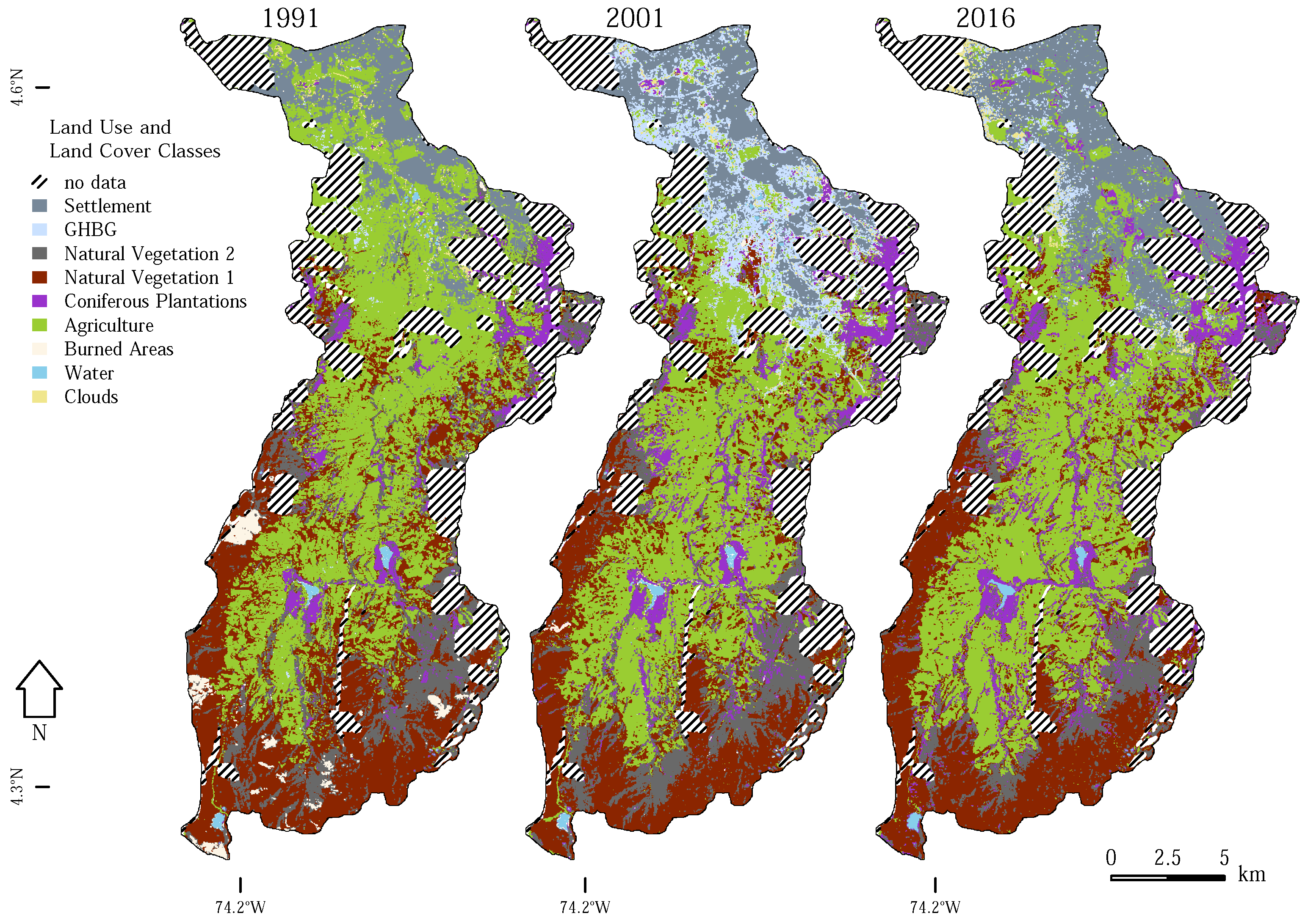
4.2. Development of Land Cover Classes
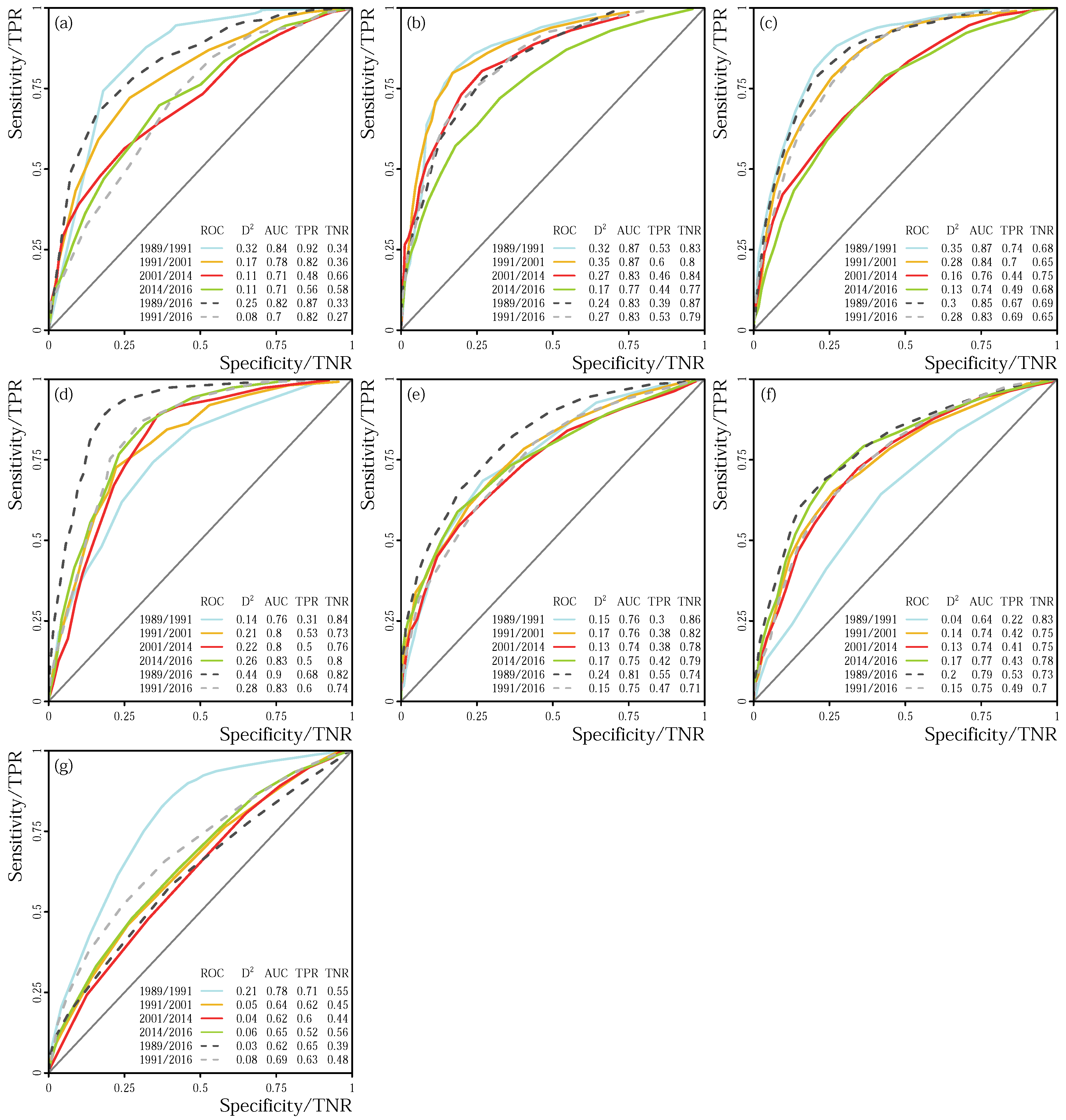
4.3. Multiple Regression Analysis
4.4. Model Performance
4.4.1. Random Forest
4.4.2. Multiple Regression Analysis
5. Discussion
5.1. Land Cover Classes
5.2. Multiple Regression Analyses
6. Conclusions
Author Contributions
Funding
Acknowledgments
Conflicts of Interest
References
- Lambin, E.F.; Turner, B.L.; Geist, H.J.; Agbola, S.B.; Angelsen, A.; Bruce, J.W.; Coomes, O.T.; Dirzo, R.; Fischer, G.; Folke, C.; et al. The causes of land-use and land-cover change: Moving beyond the myths. Glob. Environ. Chang. 2001, 11, 261–269. [Google Scholar] [CrossRef]
- Mayewski, P.A.; Rohling, E.E.; Curt Stager, J.; Karlén, W.; Maasch, K.A.; David Meeker, L.; Meyerson, E.A.; Gasse, F.; van Kreveld, S.; Holmgren, K.; et al. Holocene climate variability. Quat. Res. 2004, 62, 243–255. [Google Scholar] [CrossRef]
- Matthews, H.D.; Weaver, A.J.; Meissner, K.J.; Gillett, N.P.; Eby, M. Natural and anthropogenic climate change: Incorporating historical land cover change, vegetation dynamics and the global carbon cycle. Clim. Dyn. 2004, 22, 461–479. [Google Scholar] [CrossRef]
- Vonmoos, M.; Beer, J.; Muscheler, R. Large variations in Holocene solar activity: Constraints from 10Be in the Greenland Ice Core Project ice core. J. Geophys. Res. Space Phys. 2006, 111. [Google Scholar] [CrossRef]
- Wanner, H.; Beer, J.; Bütikofer, J.; Crowley, T.J.; Cubasch, U.; Flückiger, J.; Goosse, H.; Grosjean, M.; Joos, F.; Kaplan, J.O.; et al. Mid- to Late Holocene climate change: An overview. Quat. Sci. Rev. 2008, 27, 1791–1828. [Google Scholar] [CrossRef]
- Ramankutty, N.; Graumlich, L.; Achard, F.; Alves, D.; Chhabra, A.; DeFries, R.S.; Foley, J.A.; Geist, H.; Houghton, R.A.; Goldewijk, K.K.; et al. Global Land-Cover Change: Recent Progress, Remaining Challenges. In Land-Use and Land-Cover Change; Lambin, E.F., Geist, H.J., Eds.; Global Change—The IGBP Series; Springer: Berlin/Heidelberg, Germany, 2006; pp. 9–39. [Google Scholar]
- Lepers, E.; Lambin, E.F.; Janetos, A.C.; DeFries, R.; Achard, F.; Ramankutty, N.; Scholes, R.J. A Synthesis of Information on Rapid Land-cover Change for the Period 1981–2000. BioScience 2005, 55, 115–124. [Google Scholar] [CrossRef]
- Gonzalez, P.; Neilson, R.P.; Lenihan, J.M.; Drapek, R.J. Global patterns in the vulnerability of ecosystems to vegetation shifts due to climate change. Glob. Ecol. Biogeogr. 2010, 19, 755–768. [Google Scholar] [CrossRef]
- Potts, S.G.; Biesmeijer, J.C.; Kremen, C.; Neumann, P.; Schweiger, O.; Kunin, W.E. Global pollinator declines: trends, impacts and drivers. Trends Ecol. Evol. 2010, 25, 345–353. [Google Scholar] [CrossRef] [PubMed]
- Leimu, R.; Vergeer, P.; Angeloni, F.; Ouborg, N.J. Habitat fragmentation, climate change, and inbreeding in plants. Ann. N. Y. Acad. Sci. 2010, 1195, 84–98. [Google Scholar] [CrossRef] [PubMed]
- Cao, Q.; Yu, D.; Georgescu, M.; Han, Z.; Wu, J. Impacts of land use and land cover change on regional climate: A case study in the agro-pastoral transitional zone of China. Environ. Res. Lett. 2015, 10, 124025. [Google Scholar] [CrossRef]
- Fahrig, L. Effects of Habitat Fragmentation on Biodiversity. Annu. Rev. Ecol. Evol. Syst. 2003, 34, 487–515. [Google Scholar] [CrossRef]
- Newbold, T.; Hudson, L.N.; Hill, S.L.L.; Contu, S.; Lysenko, I.; Senior, R.A.; Börger, L.; Bennett, D.J.; Choimes, A.; Collen, B.; et al. Global effects of land use on local terrestrial biodiversity. Nature 2015, 520, 45–50. [Google Scholar] [CrossRef] [PubMed]
- Jetz, W.; Wilcove, D.S.; Dobson, A.P. Projected Impacts of Climate and Land-Use Change on the Global Diversity of Birds. PLoS Biol. 2007, 5, e157. [Google Scholar] [CrossRef] [PubMed]
- Philpott, S.M.; Arendt, W.J.; Armbrecht, I.; Bichier, P.; Diestch, T.V.; Gordon, C.; Greenberg, R.; Perfecto, I.; Reynoso-Santos, R.; Soto-Pinto, L.; et al. Biodiversity Loss in Latin American Coffee Landscapes: Review of the Evidence on Ants, Birds, and Trees. Conserv. Biol. 2008, 22, 1093–1105. [Google Scholar] [CrossRef] [PubMed]
- Flynn, D.F.B.; Gogol-Prokurat, M.; Nogeire, T.; Molinari, N.; Richers, B.T.; Lin, B.B.; Simpson, N.; Mayfield, M.M.; DeClerck, F. Loss of functional diversity under land use intensification across multiple taxa. Ecol. Lett. 2009, 12, 22–33. [Google Scholar] [CrossRef] [PubMed]
- Perfecto, I.; Vandermeer, J.; Hanson, P.; Cartín, V. Arthropod biodiversity loss and the transformation of a tropical agro-ecosystem. Biodivers. Conserv. 1997, 6, 935–945. [Google Scholar] [CrossRef]
- Duffy, J.E. Biodiversity loss, trophic skew and ecosystem functioning. Ecol. Lett. 2003, 6, 680–687. [Google Scholar] [CrossRef]
- Worm, B.; Barbier, E.B.; Beaumont, N.; Duffy, J.E.; Folke, C.; Halpern, B.S.; Jackson, J.B.C.; Lotze, H.K.; Micheli, F.; Palumbi, S.R.; et al. Impacts of Biodiversity Loss on Ocean Ecosystem Services. Science 2006, 314, 787–790. [Google Scholar] [CrossRef] [PubMed]
- Lambin, E.F.; Geist, H.J.; Lepers, E. Dynamics of Land-Use and Land-Cover Change in Tropical Regions. Ann. Rev. Environ. Resour. 2003, 28, 205–241. [Google Scholar] [CrossRef]
- Hooghiemstra, H.; Wijninga, V.M.; Cleef, A.M. The paleobotanical record of colombia: Implications for biogeography and biodiversity. Ann. Mo. Bot. Gard. 2006, 93, 297–325. [Google Scholar] [CrossRef]
- Buytaert, W.; De Bièvre, B.; Wyseure, G.; Deckers, J. The use of the linear reservoir concept to quantify the impact of changes in land use on the hydrology of catchments in the Andes. Hydrol. Earth Syst. Sci. Discuss. 2004, 8, 108–114. [Google Scholar] [CrossRef]
- Molina, A.; Govers, G.; Vanacker, V.; Poesen, J.; Zeelmaekers, E.; Cisneros, F. Runoff generation in a degraded Andean ecosystem: Interaction of vegetation cover and land use. Catena 2007, 71, 357–370. [Google Scholar] [CrossRef]
- Flores-López, F.; Galaitsi, S.E.; Escobar, M.; Purkey, D. Modeling of Andean Páramo Ecosystems’ Hydrological Response to Environmental Change. Water 2016, 8, 94. [Google Scholar] [CrossRef]
- Hofstede, R.G.M. Effects of livestock farming and recommendations for management and conservation of páramo grasslands (Colombia). Land Degrad. Dev. 1995, 6, 133–147. [Google Scholar] [CrossRef]
- Restrepo, J.D.; Syvitski, J.P.M. Assessing the Effect of Natural Controls and Land Use Change on Sediment Yield in a Major Andean River: The Magdalena Drainage Basin, Colombia. AMBIO J. Hum. Environ. 2006, 35, 65–74. [Google Scholar] [CrossRef]
- Harden, C.P. Land Use, Soil Erosion, and Reservoir Sedimentation in an Andean Drainage Basin in Ecuador. Mt. Res. Dev. 1993, 13, 177–184. [Google Scholar] [CrossRef]
- Ramos, A.M.C.; Trujillo-Vela, M.G.; Prada, L.F.S. Análisis descriptivos de procesos de remoción en masa en Bogotá. Obras y Proyectos 2015, 18, 63–75. [Google Scholar] [CrossRef]
- Feeley, K.J.; Silman, M.R. Land-use and climate change effects on population size and extinction risk of Andean plants. Glob. Chang. Biol. 2010, 16, 3215–3222. [Google Scholar] [CrossRef]
- DANE. Censo de Poblacion (9 de Mayo de 1951); Departamento Administrativo Nacional de Estadística: Bogotá, Colombia, 1954. [Google Scholar]
- DANE. XVI Censo Nacional de Población y V de Vivienda 1993; Departamento Administrativo Nacional de Estadística: Bogotá, Colombia, 1996. [Google Scholar]
- Helmens, K.F.; van der Hammen, T. The Pliocene and Quaternary of the high plain of Bogotá (Colombia): A history of tectonic uplift, basin development and climatic change. Quat. Int. 1994, 21, 41–61. [Google Scholar] [CrossRef]
- Andriessen, P.A.M.; Helmens, K.F.; Hooghiemstra, H.; Riezebos, P.A.; van der Hammen, T. Absolute chronology of the Pliocene-Quaternary sediment sequence of the Bogota area, Colombia. Quat. Sci. Rev. 1994, 12, 483–501. [Google Scholar] [CrossRef]
- Vargas, H.R.; Espinoza, B.A.; Nuñez, T.A.; Gonzalez, I.H.; Orrego, L.A.; Etayo, S.F.; Duque-Caro, H.; Mendoza, F.H.; Paris, Q.G. Mapa Geologico de Colombia, Scale 1:1500000; Ministerio de Minas y Petroleos: Bogotá, Colombia, 1988. [Google Scholar]
- Guhl Nimtz, E. Páramos Circundantes de la Sábana de Bogotá, 2nd ed.; Jardín Botánico “José Celestino Mutis”: Bogotá, Colombia, 1982. [Google Scholar]
- Mark, B.G.; Helmens, K.F. Reconstruction of glacier equilibrium-line altitudes for the Last Glacial Maximum on the High Plain of Bogotá, Eastern Cordillera, Colombia: Climatic and topographic implications. J. Quat. Sci. 2005, 20, 789–800. [Google Scholar] [CrossRef]
- Wada, K. Distinctive properties of Andosols. In Advances in Soil Science; Springer: New York, NY, USA, 1985; pp. 173–229. [Google Scholar]
- Jungerius, P.D. The properties of volcanic ash soils in dry parts of the Colombian andes and their relation to soil erodibility. Catena 1975, 2, 69–80. [Google Scholar] [CrossRef]
- Buytaert, W.; Deckers, J.; Wyseure, G. Description and classification of nonallophanic Andosols in south Ecuadorian alpine grasslands (páramo). Geomorphology 2006, 73, 207–221. [Google Scholar] [CrossRef]
- Sarmiento, G. Ecologically crucial features of climate in high tropical mountains. In High Altitude Tropical Biogeography; Vuilleumier, F., Monasterio, M., Eds.; Oxford University Press: Oxford, UK, 1986; pp. 11–45. [Google Scholar]
- IDEAM. Daily Rainfall Values from Australia Station [21201300]; Instituto de Hidrologia, Meteorologia y Estudios Ambientales: Bogotá, Colombia, 2017. [Google Scholar]
- Danielson, J.J.; Dahl, D.B. Global Multi-Resolution Terrain Elevation Data 2010 (GMTED2010); USGS Open File Report 2011-1073; USGS: Reston, VA, USA, 2011.
- Kattan, G.H.; Franco, P.; Rojas, V.; Morales, G. Biological diversification in a complex region: A spatial analysis of faunistic diversity and biogeography of the Andes of Colombia. J. Biogeogr. 2004, 31, 1829–1839. [Google Scholar] [CrossRef]
- Pennington, R.T.; Lavin, M.; Särkinen, T.; Lewis, G.P.; Klitgaard, B.B.; Hughes, C.E. Contrasting plant diversification histories within the Andean biodiversity hotspot. Proc. Natl. Acad. Sci. USA 2010, 107, 13783–13787. [Google Scholar] [CrossRef] [PubMed]
- Ulloa, C.U.; Acevedo-Rodríguez, P.; Beck, S.; Belgrano, M.J.; Bernal, R.; Berry, P.E.; Brako, L.; Celis, M.; Davidse, G.; Forzza, R.C.; et al. An integrated assessment of the vascular plant species of the Americas. Science 2017, 358, 1614–1617. [Google Scholar] [CrossRef] [PubMed]
- Cleef, A.M. The Vegetation of the PáRamos of the Colombian Cordillera Oriental, Reprinted ed.; Dissertationes Botanicae 61; Elsevier: Amsterdam, The Netherlands, 1981. [Google Scholar]
- Madriñán, S.; Cortés, A.J.; Richardson, J.E. Páramo is the world’s fastest evolving and coolest biodiversity hotspot. Front. Genet. 2013, 4, 192. [Google Scholar] [CrossRef] [PubMed]
- Balthazar, V.; Vanacker, V.; Molina, A.; Lambin, E.F. Impacts of forest cover change on ecosystem services in high Andean mountains. Ecol. Indic. 2015, 48, 63–75. [Google Scholar] [CrossRef]
- Hofstede, R.G.M.; Castillo, M.X.M.; Osorio, C.M.R. Biomass of Grazed, Burned, and Undisturbed Páramo Grasslands, Colombia. I. Aboveground Vegetation. Arct. Alp. Res. 1995, 27, 1–12. [Google Scholar] [CrossRef]
- Hofstede, R.G.M. The effects of grazing and burning on soil and plant nutrient concentrations in Colombian páramo grasslands. Plant Soil 1995, 173, 111–132. [Google Scholar] [CrossRef]
- Farley, K.A.; Kelly, E.F.; Hofstede, R.G.M. Soil Organic Carbon and Water Retention after Conversion of Grasslands to Pine Plantations in the Ecuadorian Andes. Ecosystems 2004, 7, 729–739. [Google Scholar] [CrossRef]
- Minaya, V.; Corzo, G.; Romero-Saltos, H.; van der Kwast, J.; Lantinga, E.; Galárraga-Sánchez, R.; Mynett, A. Altitudinal analysis of carbon stocks in the Antisana páramo, Ecuadorian Andes. J. Plant Ecol. 2016, 9. [Google Scholar] [CrossRef]
- Buytaert, W.; De Bièvre, B. Water for cities: The impact of climate change and demographic growth in the tropical Andes. Water Resour. Res. 2012, 48, W08503. [Google Scholar] [CrossRef]
- Morales, S.; Álvarez, C.; Acevedo, C.; Diaz, C.; Rodriguez, M.; Pacheco, L. An overview of small hydropower plants in Colombia: Status, potential, barriers and perspectives. Renew. Sustain. Energy Rev. 2015, 50, 1650–1657. [Google Scholar] [CrossRef]
- Martínez, V.; Castillo, O.L. The political ecology of hydropower: Social justice and conflict in Colombian hydroelectricity development. Energy Res. Soc. Sci. 2016, 22, 69–78. [Google Scholar] [CrossRef]
- Buytaert, W.; Breuer, T. Water resources in South America: Sources and supply, pollutants and perspectives. In Proceedings of the IAHS-IAPSO-IASPEI Assembly, Gothenburg, Sweden, 22–26 July 2013; pp. 1–9. [Google Scholar]
- Buytaert, W.; Célleri, R.; De Bièvre, B.; Cisneros, F.; Wyseure, G.; Deckers, J.; Hofstede, R. Human impact on the hydrology of the Andean páramos. Earth Sci. Rev. 2006, 79, 53–72. [Google Scholar] [CrossRef]
- Buytaert, W.; Sevink, J.; De Leeuw, B.; Deckers, J. Clay mineralogy of the soils in the south Ecuadorian páramo region. Geoderma 2005, 127, 114–129. [Google Scholar] [CrossRef]
- Podwojewski, P.; Poulenard, J. Paramos soils. In Encyclopedia of Soil Science, 2nd ed.; Lal, R., Ed.; Taylor & Francis: New York, NY, USA, 2004; pp. 1239–1242. [Google Scholar]
- Rangel Churio, J.O. The Biodiversity of the Colombian Paramo and its Relation to Anthropogenic Impact. In Land Use Change and Mountain Biodiversity; Spehn, E.M., Liberman, M., Korner, C., Eds.; CRC Press: Boca Raton, FL, USA, 2006; pp. 103–118. [Google Scholar]
- Young, K.R. Roads and the Environmental Degradation of Tropical Montane Forests. Conserv. Biol. 1994, 8, 972–976. [Google Scholar] [CrossRef]
- Armenteras, D.; Rodríguez, N.; Retana, J.; Morales, M. Understanding deforestation in montane and lowland forests of the Colombian Andes. Reg. Environ. Chang. 2011, 11, 693–705. [Google Scholar] [CrossRef]
- Lutz, D.A.; Powell, R.L.; Silman, M.R. Four Decades of Andean Timberline Migration and Implications for Biodiversity Loss with Climate Change. PLoS ONE 2013, 8, e74496. [Google Scholar] [CrossRef] [PubMed]
- Etter, A.; McAlpine, C.; Wilson, K.; Phinn, S.; Possingham, H. Regional patterns of agricultural land use and deforestation in Colombia. Agric. Ecosyst. Environ. 2006, 114, 369–386. [Google Scholar] [CrossRef]
- van der Hammen, T. The Pleistocene Changes of Vegetation and Climate in Tropical South America. J. Biogeogr. 1974, 1, 3–26. [Google Scholar] [CrossRef]
- van der Hammen, T.; Correal Urrego, G. Mastodontes en el humedal pleistocénico en el valle del Magdalena (Colombia) con evidencias de la presencia del hombre en el pleniglacial. Bol. Arqueol. 2001, 16, 1. [Google Scholar]
- Delgado Burbano, M.E. Mid and Late Holocene population changes at the Sabana de Bogotá (Northern South America) inferred from skeletal morphology and radiocarbon chronology. Quat. Int. 2012, 256, 2–11. [Google Scholar] [CrossRef]
- Etter, A.; McAlpine, C.; Possingham, H. Historical Patterns and Drivers of Landscape Change in Colombia Since 1500: A Regionalized Spatial Approach. Ann. Assoc. Am. Geogr. 2008, 98, 2–23. [Google Scholar] [CrossRef]
- Etter, A.; van Wyngaarden, W. Patterns of Landscape Transformation in Colombia, with Emphasis in the Andean Region. AMBIO J. Hum. Environ. 2000, 29, 432–439. [Google Scholar] [CrossRef]
- van Ausdal, S. Pasture, profit, and power: An environmental history of cattle ranching in Colombia, 1850–1950. Geoforum 2009, 40, 707–719. [Google Scholar] [CrossRef]
- Parsons, J.J. Spread of African Pasture Grasses to the American Tropics. J. Range Manag. 1972, 25, 12–17. [Google Scholar] [CrossRef]
- Williams, D.G.; Baruch, Z. African Grass Invasion in the Americas: Ecosystem Consequences and the Role of Ecophysiology. Biol. Invasions 2000, 2, 123–140. [Google Scholar] [CrossRef]
- Osorio, J.A.O. El río Tunjuelo en la Historia de Bogotá, 1900–1990; Alcaldía Mayor de Bogotá: Bogotá, Colombia, 2007. [Google Scholar]
- Gallini, S.; Osorio, C.C. Modernity and the Silencing of Nature in Nineteenth-Century Maps of Bogotá. J. Latin Am. Geogr. 2015, 14, 91–125. [Google Scholar] [CrossRef]
- Houghton, R.A.; Lefkowitz, D.S.; Skole, D.L. Changes in the landscape of Latin America between 1850 and 1985 I. Progressive loss of forests. For. Ecol. Manag. 1991, 38, 143–172. [Google Scholar] [CrossRef]
- DANE. XIII Censo Nacional de Poblacion y II de Edificios y Viviendas (Julio 15 de 1964); Departamento Administrativo Nacional de Estadística: Bogotá, Colombia, 1969. [Google Scholar]
- Vélez-Torres, I. Governmental extractivism in Colombia: Legislation, securitization and the local settings of mining control. Political Geogr. 2014, 38, 68–78. [Google Scholar] [CrossRef]
- Silva, N.B. Efectos ambientales y sociales de la minería y las curtiembres: Dos escenarios estratégicos en la cuenca media del río Tunjuelo. Katharsis 2015, 0, 181–206. [Google Scholar] [CrossRef]
- Forero, A.R.; Mantilla, J.F.G.; Martínez, R.S. Accumulation of Lead, Chromium, and Cadmium in Muscle of capitán (Eremophilus), a Catfish from the Bogota River Basin. Arch. Environ. Contam. Toxicol. 2009, 57, 359–365. [Google Scholar] [CrossRef] [PubMed]
- Rueda-García, N. The case of Bogota DC. Global Report on Human Settlements 2003; DPU University College London: London, UK, 2003. [Google Scholar]
- Eraso, N.R.; Armenteras-Pascual, D.; Alumbreros, J.R. Land use and land cover change in the Colombian Andes: Dynamics and future scenarios. J. Land Use Sci. 2013, 8, 154–174. [Google Scholar] [CrossRef]
- Mendoza, S.J.E.; Etter, R.A. Multitemporal analysis (1940–1996) of land cover changes in the southwestern Bogotá highplain (Colombia). Landsc. Urban Plan. 2002, 59, 147–158. [Google Scholar] [CrossRef]
- Sánchez-Cuervo, A.M.; Aide, T.M.; Clark, M.L.; Etter, A. Land Cover Change in Colombia: Surprising Forest Recovery Trends between 2001 and 2010. PLoS ONE 2012, 7, e43943. [Google Scholar] [CrossRef] [PubMed]
- Rubiano, K.; Clerici, N.; Norden, N.; Etter, A. Secondary Forest and Shrubland Dynamics in a Highly Transformed Landscape in the Northern Andes of Colombia (1985–2015). Forests 2017, 8, 216. [Google Scholar] [CrossRef]
- Sánchez-Cuervo, A.M.; Aide, T.M. Consequences of the Armed Conflict, Forced Human Displacement, and Land Abandonment on Forest Cover Change in Colombia: A Multi-scaled Analysis. Ecosystems 2013, 16, 1052–1070. [Google Scholar] [CrossRef]
- Tovar, C.; Arnillas, C.A.; Cuesta, F.; Buytaert, W. Diverging Responses of Tropical Andean Biomes under Future Climate Conditions. PLoS ONE 2013, 8, e63634. [Google Scholar] [CrossRef] [PubMed]
- Ramirez-Villegas, J.; Salazar, M.; Jarvis, A.; Navarro-Racines, C.E. A way forward on adaptation to climate change in Colombian agriculture: Perspectives towards 2050. Clim. Chang. 2012, 115, 611–628. [Google Scholar] [CrossRef]
- Nakaegawa, T.; Vergara, W. First Projection of Climatological Mean River Discharges in the Magdalena River Basin, Colombia, in a Changing Climate during the 21st Century. Hydrol. Res. Lett. 2010, 4, 50–54. [Google Scholar] [CrossRef]
- Zhu, Z.; Woodcock, C.E. Automated cloud, cloud shadow, and snow detection in multitemporal Landsat data: An algorithm designed specifically for monitoring land cover change. Remote Sens. Environ. 2014, 152, 217–234. [Google Scholar] [CrossRef]
- Zhu, Z.; Wang, S.; Woodcock, C.E. Improvement and expansion of the Fmask algorithm: Cloud, cloud shadow, and snow detection for Landsats 4–7, 8, and Sentinel 2 images. Remote Sens. Environ. 2015, 159, 269–277. [Google Scholar] [CrossRef]
- Masek, J.G.; Vermote, E.F.; Saleous, N.E.; Wolfe, R.; Hall, F.G.; Huemmrich, K.F.; Gao, F.; Kutler, J.; Lim, T.K. A Landsat surface reflectance dataset for North America, 1990–2000. IEEE Geosci. Remote Sens. Lett. 2006, 3, 68–72. [Google Scholar] [CrossRef]
- Flood, N.; Gillingham, S. Python Fmask. 2015. Available online: http://pythonfmask.org/en/latest/ (accessed on 20 December 2016).
- Barrett, B.; Raab, C.; Cawkwell, F.; Green, S. Upland vegetation mapping using Random Forests with optical and radar satellite data. Remote Sens. Ecol. Conserv. 2016, 2, 212–231. [Google Scholar] [CrossRef]
- Satterwhite, M.B. Discriminating Vegetation and Soils Using Landsat MSS and Thematic Mapper Bands and Band Ratios; Technical Report ETL-R-061; Army Engineer Topographic Labs: Fort Belvoir, VA, USA, 1984. [Google Scholar]
- Gardner, B.R.; Blad, B.L.; Thompson, D.R.; Henderson, K.E. Evaluation and interpretation of thematic mapper ratios in equations for estimating corn growth parameters. Remote Sens. Environ. 1985, 18, 225–234. [Google Scholar] [CrossRef]
- Huete, A.R. A soil-adjusted vegetation index (SAVI). Remote Sens. Environ. 1988, 25, 295–309. [Google Scholar] [CrossRef]
- Rouse, J.W.; Haar, R.; Scheel, J.; Deering, D. Monitoring Vegetation Systems in the Great Plains with ERTS. In Proceedings of the NASA, Technical Presentations Section A, Washington, DC, USA, 10–14 December 1973; Volume 1, pp. 309–317. [Google Scholar]
- Key, C.H.; Benson, N.C. Measuring and remote sensing of burn severity: The CBI and NBR. In Proceedings of the Joint Fire Science Conference and Workshop, Boise, ID, USA, 15–17 June 1999; Neuenschwander, F., Ryan, K., Eds.; University of Idaho and International Association of Wildland Fire: Boise, ID, USA, 1999; Volume 2, p. 284. [Google Scholar]
- Crist, E.P.; Cicone, R.C. A Physically-Based Transformation of Thematic Mapper Data—The TM Tasseled Cap. IEEE Trans. Geosci. Remote Sens. 1984, GE-22, 256–263. [Google Scholar] [CrossRef]
- Baig, M.H.A.; Zhang, L.; Shuai, T.; Tong, Q. Derivation of a tasselled cap transformation based on Landsat 8 at-satellite reflectance. Remote Sens. Lett. 2014, 5, 423–431. [Google Scholar] [CrossRef]
- Breiman, L. Random Forests. Mach. Learn. 2001, 45, 5–32. [Google Scholar] [CrossRef]
- Borrelli, P.; Armenteras, D.; Panagos, P.; Modugno, S.; Schütt, B. The Implications of Fire Management in the Andean Paramo: A Preliminary Assessment Using Satellite Remote Sensing. Remote Sens. 2015, 7, 11061. [Google Scholar] [CrossRef]
- Diazgranados, M. A nomenclator for the frailejones (Espeletiinae Cuatrec., Asteraceae). PhytoKeys 2012, 1–52. [Google Scholar] [CrossRef] [PubMed]
- Zúñiga-Escobar, O.; Uribe, V.A.; Torres-González, A.M.; Cuero-Guependo, R.; Peña-Óspina, J.A. Assessment of the impact of anthropic activities on carbon storage in soils of high montane ecosystems in Colombia. Agron. Colomb. 2013, 31, 112–119. [Google Scholar]
- Pontius, R.G., Jr.; Santacruz, A. Quantity, exchange, and shift components of difference in a square contingency table. Int. J. Remote Sens. 2014, 35, 7543–7554. [Google Scholar] [CrossRef]
- Farr, T.G.; Rosen, P.A.; Caro, E.; Crippen, R.; Duren, R.; Hensley, S.; Kobrick, M.; Paller, M.; Rodriguez, E.; Roth, L.; et al. The Shuttle Radar Topography Mission. Rev. Geophys. 2007, 45, RG2004. [Google Scholar] [CrossRef]
- Stevenson, J.A.; Sun, X.; Mitchell, N.C. Despeckling SRTM and other topographic data with a denoising algorithm. Geomorphology 2010, 114, 238–252. [Google Scholar] [CrossRef]
- Conrad, O.; Bechtel, B.; Bock, M.; Dietrich, H.; Fischer, E.; Gerlitz, L.; Wehberg, J.; Wichmann, V.; Böhner, J. System for Automated Geoscientific Analyses (SAGA) v. 2.1.4. Geosci. Model Dev. 2015, 8, 1991–2007. [Google Scholar] [CrossRef]
- Hengl, T.; Jesus, J.M.D.; Heuvelink, G.B.M.; Gonzalez, M.R.; Kilibarda, M.; Blagotić, A.; Shangguan, W.; Wright, M.N.; Geng, X.; Bauer-Marschallinger, B.; et al. SoilGrids250m: Global gridded soil information based on machine learning. PLoS ONE 2017, 12, e0169748. [Google Scholar] [CrossRef] [PubMed]
- OpenStreetMap Contributors. OpenStreetMap; Geofabrik GmbH: Karlsruhe, Germany, 2017. [Google Scholar]
- Pontius, R.G., Jr.; Schneider, L.C. Land-cover change model validation by an ROC method for the Ipswich watershed, Massachusetts, USA. Agric. Ecosyst. Environ. 2001, 85, 239–248. [Google Scholar] [CrossRef]
- Hanley, J.A.; McNeil, B.J. The meaning and use of the area under a receiver operating characteristic (ROC) curve. Radiology 1982, 143, 29–36. [Google Scholar] [CrossRef] [PubMed]
- Bradley, A.P. The use of the area under the ROC curve in the evaluation of machine learning algorithms. Pattern Recognit. 1997, 30, 1145–1159. [Google Scholar] [CrossRef]
- R Core Team. R: A Language and Environment for Statistical Computing; R Foundation for Statistical Computing: Vienna, Austria, 2017. [Google Scholar]
- Zapata, J. El río Tunjuelo Muere al Ritmo de la Minería en Bogotá; Vera, O., Ramirez, C., Peñuela, C., Zuluaga, M., Vargas, Y., Eds.; El Turbión: Bogotá, Colombia, 2011. [Google Scholar]
- Kraul, C. Mining Showdown in Andes over Unique Páramo Lands; Yale Environment 360: New Haven, CT, USA, 2014. [Google Scholar]
- Sanabria Martínez, M.J. Los Conflictos Ambientales Asociados con la Actividad Minera en la Cuenca Urbana del río Tunjuelo. Master’s Thesis, Universidad Nacional de Colombia, Bogotá, Colombia, 2013. [Google Scholar]
- Salcedo, A. Resisting the City. 2013. Available online: https://www.opendemocracy.net/opensecurity/andr%C3%A9s-salcedo/resisting-city (accessed on 23 November 2017).
- Villalba, M.A.R.; Ariza, L.C. Control de Inundaciones del río Tunjuelito. Rev. Topogr. Azimut 2007, 1, 65–72. [Google Scholar]
- Seto, K.C.; Fragkias, M. Quantifying Spatiotemporal Patterns of Urban Land-use Change in Four Cities of China with Time Series Landscape Metrics. Landsc. Ecol. 2005, 20, 871–888. [Google Scholar] [CrossRef]
- Díaz-Granados Ortiz, M.A.; Camacho Botero, L.A. Valoración de cambios hidrológicos en la cuenca del río Bogotá. In Revista de Ingeniería; Universidad de los Andes: Bogotá, Colombia, 2012. [Google Scholar]
- Bojacá, C.R.; Schrevens, E. Energy assessment of peri-urban horticulture and its uncertainty: Case study for Bogota, Colombia. Energy 2010, 35, 2109–2118. [Google Scholar] [CrossRef]
- Herold, M.; Roberts, D.A.; Gardner, M.E.; Dennison, P.E. Spectrometry for urban area remote sensing—Development and analysis of a spectral library from 350 to 2400 nm. Remote Sens. Environ. 2004, 91, 304–319. [Google Scholar] [CrossRef]
- Thomas, N.; Hendrix, C.; Congalton, R.G. A Comparison of Urban Mapping Methods Using High-Resolution Digital Imagery. Photogramm. Eng. Remote Sens. 2003, 69, 963–972. [Google Scholar] [CrossRef]
- Chan, J.C.W.; Bellens, R.; Canters, F.; Gautama, S. An Assessment of Geometric Activity Features for Per-pixel Classification of Urban Man-made Objects using Very High Resolution Satellite Imagery. Photogramm. Eng. Remote Sens. 2009, 75, 397–411. [Google Scholar] [CrossRef]
- Baldinelli, G.; Bonafoni, S.; Anniballe, R.; Presciutti, A.; Gioli, B.; Magliulo, V. Spaceborne detection of roof and impervious surface albedo: Potentialities and comparison with airborne thermography measurements. Sol. Energy 2015, 113, 281–294. [Google Scholar] [CrossRef]
- Jensen, J.R.; Cowen, D.C. Remote Sensing of Urban/Suburban Infrastructure and Socio-Economic Attributes. In The Map Reader; Dodge, M., Kitchin, R., Perkins, C., Eds.; John Wiley & Sons, Ltd.: London, UK, 2011; pp. 153–163. [Google Scholar]
- Gislason, P.O.; Benediktsson, J.A.; Sveinsson, J.R. Random Forests for land cover classification. Pattern Recognit. Lett. 2006, 27, 294–300. [Google Scholar] [CrossRef]
- Mellor, A.; Haywood, A.; Stone, C.; Jones, S. The Performance of Random Forests in an Operational Setting for Large Area Sclerophyll Forest Classification. Remote Sens. 2013, 5, 2838–2856. [Google Scholar] [CrossRef]
- Hastie, T.; Tibshirani, R.; Friedman, J. Random Forests. In The Elements of Statistical Learning; Springer Series in Statistics; Springer: New York, NY, USA, 2009; pp. 587–604. [Google Scholar]
- Strobl, C.; Boulesteix, A.L.; Zeileis, A.; Hothorn, T. Bias in random forest variable importance measures: Illustrations, sources and a solution. BMC Bioinform. 2007, 8, 25. [Google Scholar] [CrossRef] [PubMed]
- Isaacs-Cubides, P.J.; Trujillo-Ortiz, L.N.; Jaimes, V. Zonificación de alternativas de conectividad ecológica, restauración y conservación en las microcuencas Curubital, Mugroso, Chisacá y Regadera, cuenca del río Tunjuelo (Distrito Capital de Bogotá), Colombia. Biota Colomb. 2017, 18, 70–88. [Google Scholar] [CrossRef]
- Muñoz-Villers, L.E.; López-Blanco, J. Land use/cover changes using Landsat TM/ETM images in a tropical and biodiverse mountainous area of central-eastern Mexico. Int. J. Remote Sens. 2008, 29, 71–93. [Google Scholar] [CrossRef]
- Ozesmi, S.L.; Bauer, M.E. Satellite remote sensing of wetlands. Wetl. Ecol. Manag. 2002, 10, 381–402. [Google Scholar] [CrossRef]
- Wunder, S. Deforestation and the Uses of Wood in the Ecuadorian Andes. Mt. Res. Dev. 1996, 16, 367–381. [Google Scholar] [CrossRef]
- Jokisch, B.D.; Lair, B.M. One Last Stand? Forests and Change on Ecuador’s Eastern Cordillera. Geogr. Rev. 2002, 92, 235–256. [Google Scholar] [CrossRef]
- Schulz, J.J.; Cayuela, L.; Echeverria, C.; Salas, J.; Rey Benayas, J.M. Monitoring land cover change of the dryland forest landscape of Central Chile (1975–2008). Appl. Geogr. 2010, 30, 436–447. [Google Scholar] [CrossRef]
- Hernández-Gómez, A.; Rojas-Robles, R.; Sánchez-Calderón, F.V. Changes in Land Use Associated with Urban Expansion and Territorial Planning in Pasquilla, A Rural Area to the South of Bogotá (Colombia). Cuad. Geogr. Rev. Colomb. Geogr. 2013, 22, 257–271. [Google Scholar]
- Mertens, B.; Lambin, E.F. Land-Cover-Change Trajectories in Southern Cameroon. Ann. Assoc. Am. Geogr. 2000, 90, 467–494. [Google Scholar] [CrossRef]
- Hess, C.G. “Moving up-Moving down”: Agro-Pastoral Land-Use Patterns in the Ecuadorian Paramos. Mt. Res. Dev. 1990, 10, 333–342. [Google Scholar] [CrossRef]
- Sarmiento, F.O.; Frolich, L.M. Andean Cloud Forest Tree Lines. Mt. Res. Dev. 2002, 22, 278–287. [Google Scholar] [CrossRef]
- Tobler, W.R. A computer movie simulating urban growth in the Detroit region. Econ. Geogr. 1970, 46, 234–240. [Google Scholar] [CrossRef]
- Endo, M. CAMCORE: Twelve years of contribution to reforestation in the Andean region of Colombia. For. Ecol. Manag. 1994, 63, 219–233. [Google Scholar] [CrossRef]
- Grimm, N.B.; Faeth, S.H.; Golubiewski, N.E.; Redman, C.L.; Wu, J.; Bai, X.; Briggs, J.M. Global Change and the Ecology of Cities. Science 2008, 319, 756–760. [Google Scholar] [CrossRef] [PubMed]
- Verburg, P.H.; Eck, J.R.R.v.; Nijs, T.C.M.d.; Dijst, M.J.; Schot, P. Determinants of Land-Use Change Patterns in the Netherlands. Environ. Plan. B Plan. Des. 2004, 31, 125–150. [Google Scholar] [CrossRef]
- Seto, K.C.; Kaufmann, R.K. Modeling the Drivers of Urban Land Use Change in the Pearl River Delta, China: Integrating Remote Sensing with Socioeconomic Data. Land Econ. 2003, 79, 106–121. [Google Scholar] [CrossRef]
- Mundia, C.N.; Aniya, M. Analysis of land use/cover changes and urban expansion of Nairobi city using remote sensing and GIS. Int. J. Remote Sens. 2005, 26, 2831–2849. [Google Scholar] [CrossRef]
- Wu, Q.; Li, H.Q.; Wang, R.S.; Paulussen, J.; He, Y.; Wang, M.; Wang, B.H.; Wang, Z. Monitoring and predicting land use change in Beijing using remote sensing and GIS. Landsc. Urban Plan. 2006, 78, 322–333. [Google Scholar] [CrossRef]
- Podwojewski, P.; Poulenard, J.; Zambrana, T.; Hofstede, R. Overgrazing effects on vegetation cover and properties of volcanic ash soil in the páramo of Llangahua and La Esperanza (Tungurahua, Ecuador). Soil Use Manag. 2002, 18, 45–55. [Google Scholar] [CrossRef]
- Hofstede, R.; Coppus, R.; Vásconez, P.M.; Segarra, P.; Wolf, J.; Sevink, J. El estado de conservación de los páramos de pajonal en el Ecuador. Ecotropicos 2002, 15, 3–18. [Google Scholar]
- Otero, J.D.; Figueroa, A.; Muñoz, F.A.; Peña, M.R. Loss of soil and nutrients by surface runoff in two agro-ecosystems within an Andean paramo area. Ecol. Eng. 2011, 37, 2035–2043. [Google Scholar] [CrossRef]
- Munroe, D.K.; Southworth, J.; Tucker, C.M. The dynamics of land-cover change in western Honduras: Exploring spatial and temporal complexity. Agric. Econ. 2002, 27, 355–369. [Google Scholar] [CrossRef]
- Pérez, F.L. The effects of giant Andean rosettes on surface soils along a high paramo toposequence. GeoJournal 1996, 40, 283–298. [Google Scholar] [CrossRef]
- Hofstede, R.G.M.; Groenendijk, J.P.; Coppus, R.; Fehse, J.C.; Sevink, J. Impact of Pine Plantations on Soils and Vegetation in the Ecuadorian High Andes. Mt. Res. Dev. 2002, 22, 159–167. [Google Scholar] [CrossRef]
- Farley, K.A.; Kelly, E.F. Effects of afforestation of a páramo grassland on soil nutrient status. For. Ecol. Manag. 2004, 195, 281–290. [Google Scholar] [CrossRef]
- Abreu, Z.; Llambí, L.D.; Sarmiento, L. Sensitivity of Soil Restoration Indicators during Páramo Succession in the High Tropical Andes: Chronosequence and Permanent Plot Approaches. Restor. Ecol. 2009, 17, 619–627. [Google Scholar] [CrossRef]
- López, E.; Bocco, G.; Mendoza, M.; Duhau, E. Predicting land-cover and land-use change in the urban fringe: A case in Morelia city, Mexico. Landsc. Urban Plan. 2001, 55, 271–285. [Google Scholar] [CrossRef]
- Bates, M. Climate and Vegetation in the Villavicencio Region of Eastern Colombia. Geogr. Rev. 1948, 38, 555–574. [Google Scholar] [CrossRef]
- Molinillo, M.; Monasterio, M. Pastoralism in Paramo Environments: Practices, Forage, and Impact on Vegetation in the Cordillera of Merida, Venezuela. Mt. Res. Dev. 1997, 17, 197–211. [Google Scholar] [CrossRef]
- Robineau, O.; Châtelet, M.; Soulard, C.T.; Michel-Dounias, I.; Posner, J. Integrating Farming and Páramo Conservation: A Case Study From Colombia. Mt. Res. Dev. 2010, 30, 212–221. [Google Scholar] [CrossRef]
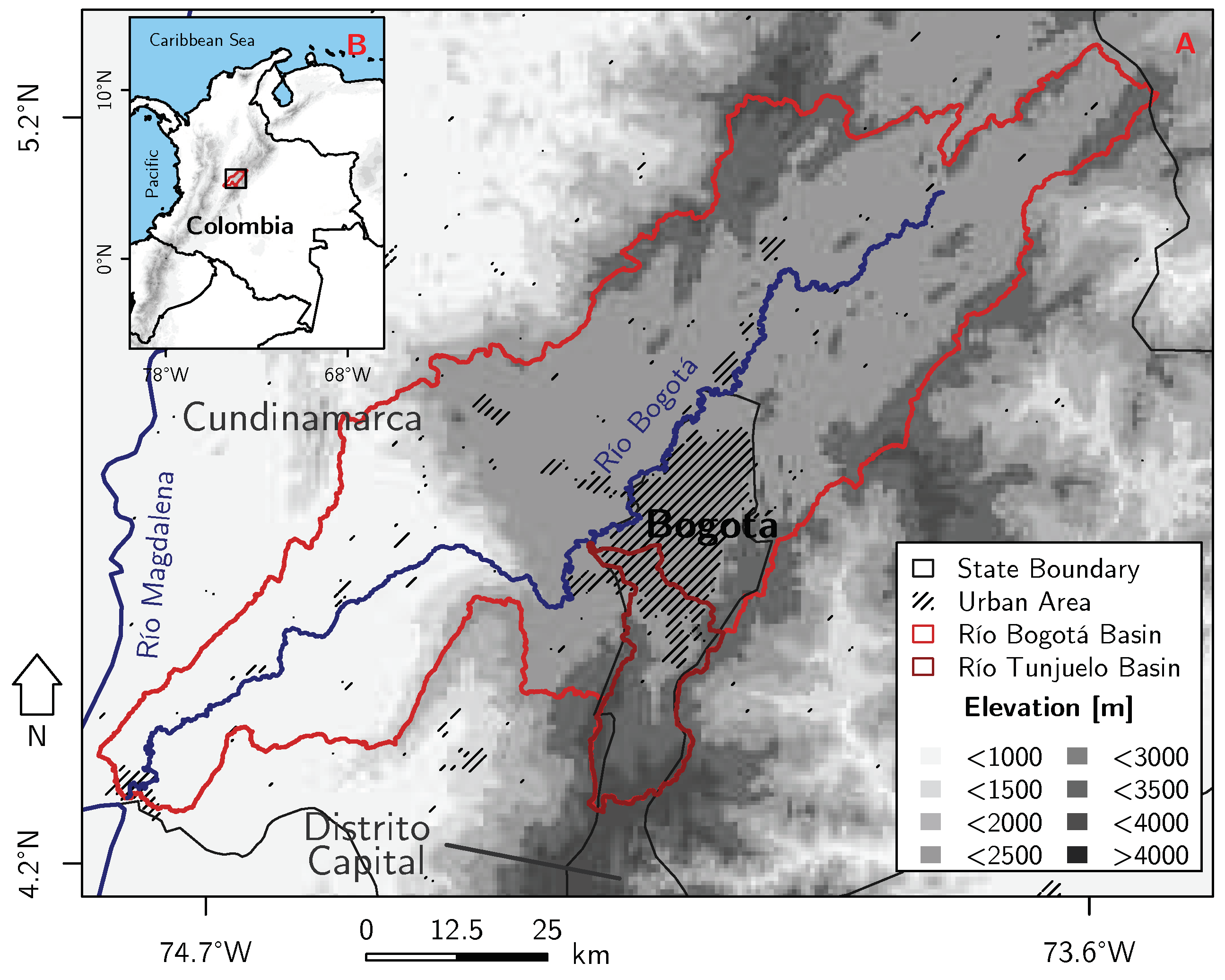
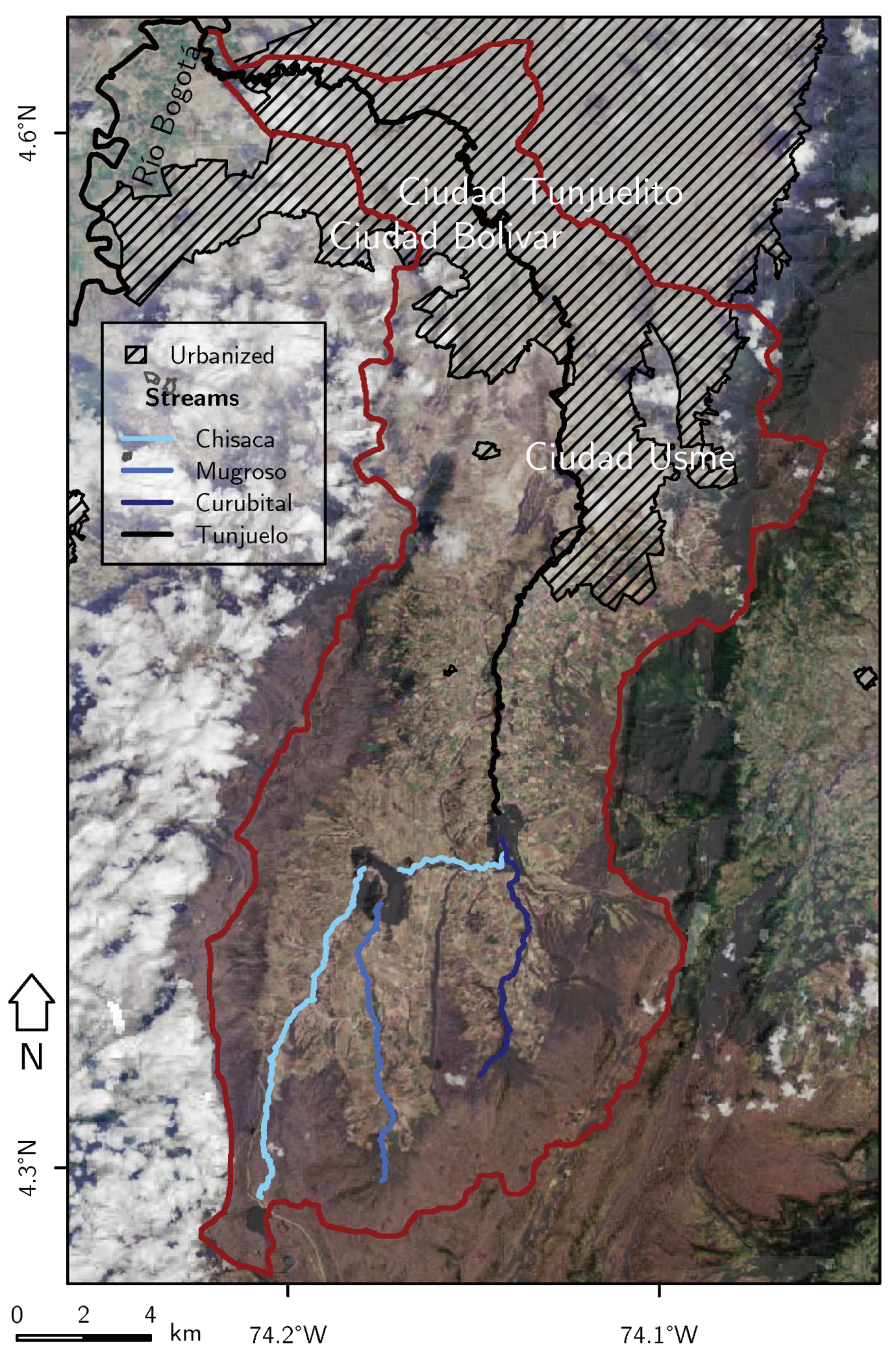
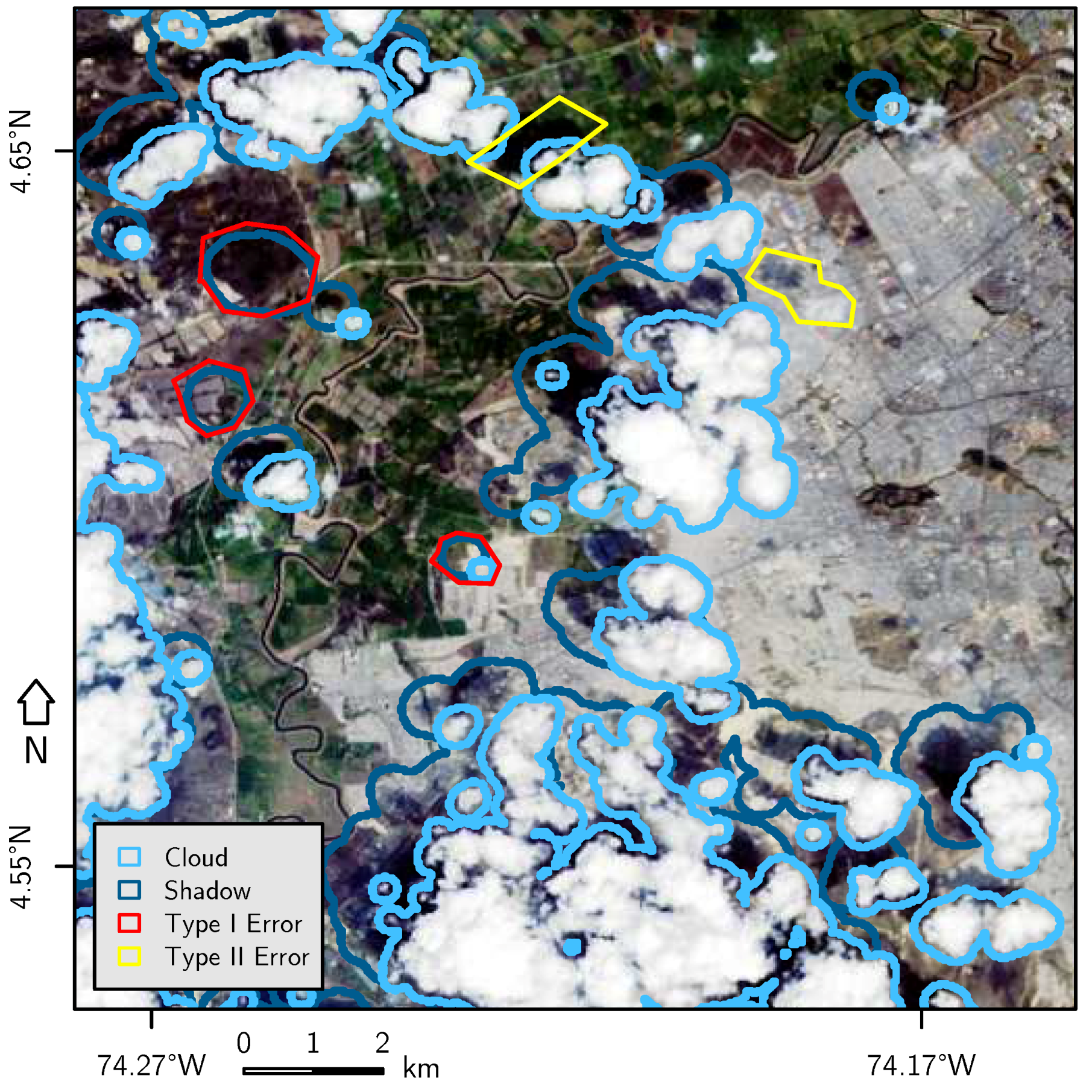
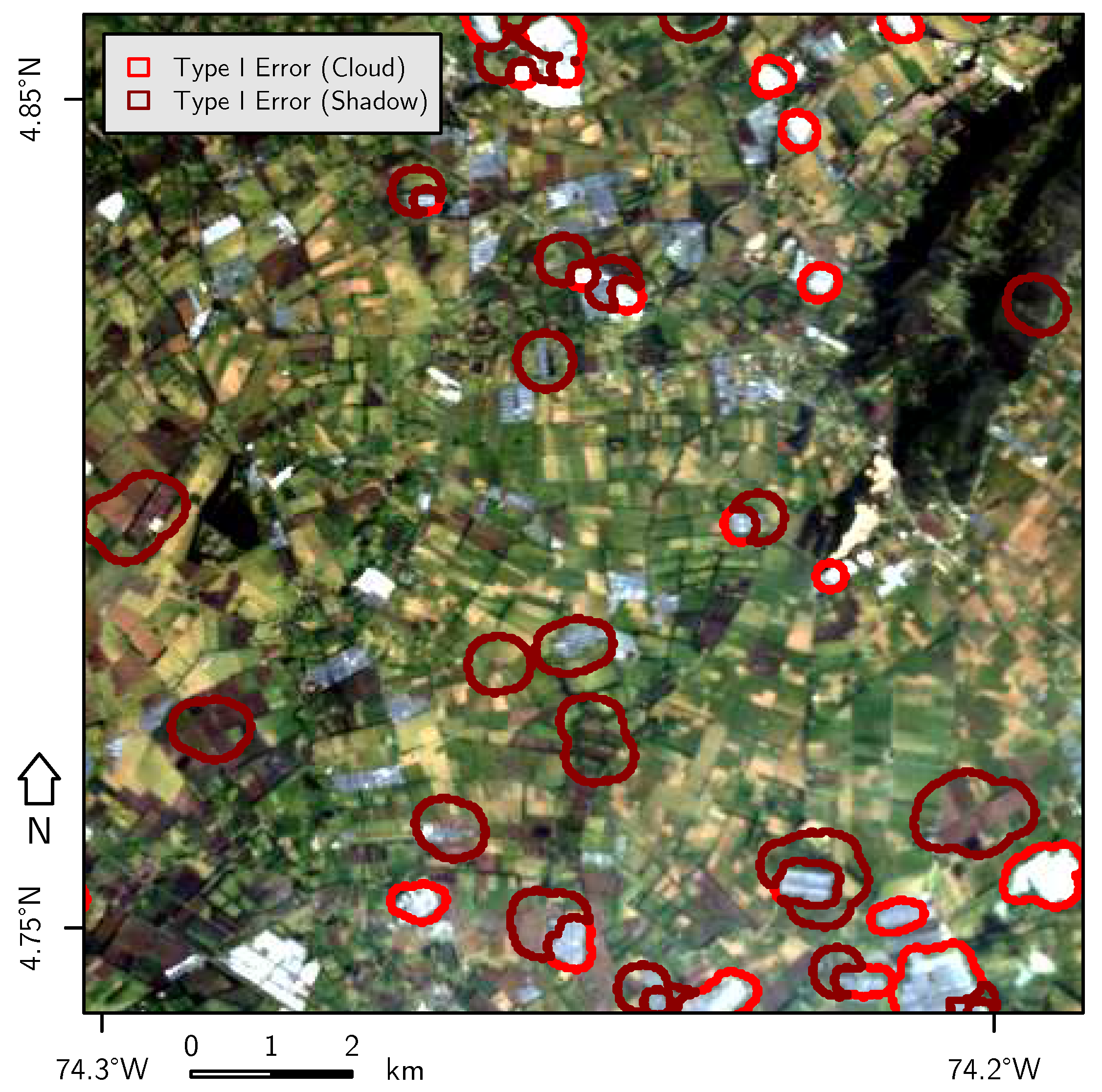

| Date | Sensor | Cloud Cover [%] |
|---|---|---|
| 22 December 1989 | TM | 10.0 |
| 19 February 1991 | TM | 30.0 |
| 29 January 2001 | TM | 0.0 |
| 1 January 2014 | OLI | 20.51 |
| 23 January 2016 | OLI | 46.86 |
| Spatial Extent [%] | |||||||
|---|---|---|---|---|---|---|---|
| Class | Class Description | Separation Approach | 1989 | 1991 | 2001 | 2014 | 2016 |
| GHBG | greenhouses appear as large complexes, bare ground is the land surface with exposed bright sandstone | derived from image interpretation, large variation in the digital numbers but with similar characteristics of the spectral curve | 1.7 | 0.3 | 8.5 | 5.7 | 1.3 |
| Settlement | densely populated areas, build-up areas or otherwise sealed areas | knowledge based classified in combination with visual image interpretation | 11.5 | 10.0 | 11.2 | 11.9 | 14.5 |
| Natural Vegetation 1 | Espeletia (frailejon) covered high-altitude ecosystem (Páramo) as stated in Diazgranados et al. [103], often on slopes, no very thick solum and rather shallow vegetation cover | knowledge based classified in combination with visual image interpretation | 29.6 | 32.9 | 22.5 | 21.0 | 23.7 |
| Natural Vegetation 2 | high vegetation cover, often shrubby, thicker solum than Nat. Vegetation 1 class, gradual transition to Nat. Vegetation 1 class, most likely Bosque Altoandino and other forest-like ecosystems occur here | knowledge based classified in combination with visual image interpretation | 13.0 | 15.4 | 15.5 | 14.2 | 11.8 |
| CP | coniferous plantations | knowledge based classified in combination with visual image interpretation | 6.9 | 2.9 | 6.2 | 5.8 | 7.2 |
| Agriculture | mostly agricultural fields and mosaics used for ranching and farming | mostly based on the ratio of red and near-infrared bands, derived from agricultural fields only | 36.0 | 35.6 | 34.7 | 40.6 | 40.8 |
| Burned Areas | burning scars of wildfires, mostly surrounded by Natural Vegetation 1 class | derived from very low reflectances in the visible spectrum and near-infrared | 0.7 | 1.2 | 0.2 | – | 0.1 |
| Clouds | derived from clouds | very high reflective values in blue band | 0.1 | 0.3 | 0.7 | 0.1 | 0.5 |
| Water | natural and artificial water bodies | very low reflectance, especially in near-infrared/infrared bands | 0.3 | 0.3 | 0.4 | 0.6 | 0.3 |
| Time Intervals | ||||||||
|---|---|---|---|---|---|---|---|---|
| Predictor | 1989–1991 | 1991–2001 | 2001–2014 | 2014–2016 | 1989–2016 | 1991–2016 | ||
| Terrain | Parameters | Elevation | NV1, NV | NV1, NV | NV1, NV | NV1, NV | ||
| Slope | NV2 | NV2 | NV1, NV2 | NV1 | ||||
| Aspect | NV1 | NV1 | NV1, NV | NV1, NV | NV1, NV | |||
| Profile Curvature | ||||||||
| Tangential Curvature | GB, GBSM | GB, GBSM | ||||||
| Distances | Distance to GHBG | SM, NV2 | SM | SM, NV2 | SM | SM, NV2 | SM, NV2 | |
| Distance to Settlement | NV1, NV2 | NV2 | NV1, NV | NV | ||||
| Distance to CP | NV2 | GB | GB, NV1, NV2 | GB, GBSM, NV1 | GB, GBSM, NV1, NV2 | GB, NV1, NV2 | ||
| Distance to Natural Vegetation 1 | SM, GBSM | SM, GBSM | SM, GBSM | SM, GBSM, GBSM | ||||
| Distance to Natural Vegetation 2 | GB, SM | GB, NV1 | SM | GB, NV1 | GB | NV1 | ||
| Distance to Agriculture | SM, NV, AC | SM, GBSM, NV1, NV, AC | SM, GBSM, NV1, NV, AC | SM, NV | SM, NV | NV1, NV | ||
| Distance to Burned Areas | NV1, NV2 | GBSM | SM, NV2, NV | SM, NV1, NV | SM, GBSM, AC | AC | ||
| Distance to Water | SM | SM | AC | AC | AC | |||
| Distance to Street | NV2 | GB, NV1, NV2 | SM | GB, NV1 | GB, SM, NV2 | SM, NV1, NV2 | ||
| Distance to Stream | NV2 | GB, NV1, NV2 | GB, NV1 | NV1 | ||||
| Soil Chemical and | Physical Parameters | Soil Cation Exchange Capacity | GB | GB, GBSM, NV1, NV | NV1, NV2, NV, AC | GB, GBSM, NV2, AC | GBSM, NV1, NV | |
| Soil Organic Carbon Content | SM | GB, SM, GBSM | GB, GBSM, NV | GBSM, NV2 | NV2, NV | GB, SM, GBSM, NV2, NV | ||
| Soil pH | GBSM, AC | GBSM, NV | GB, GBSM | GB, GBSM, NV | GBSM, NV | GBSM, NV, AC | ||
| Bulk Density | SM, GBSM | SM, GBSM | SM, GBSM | |||||
| Depth to Bedrock | AC | AC | ||||||
| Gravel Content | SM, NV2 | GBSM | SM, GBSM | NV2 | SM | |||
| Sand Content | AC | AC | ||||||
| Silt Content | GBSM | GBSM | NV1 | NV2 | GBSM, NV1, NV2 | |||
| Clay Content | NV | NV | ||||||
| Year | 1989 | 1991 | 2001 | 2014 | 2016 |
|---|---|---|---|---|---|
| Kappa Index | 0.964 | 0.953 | 0.959 | 0.985 | 0.974 |
© 2018 by the authors. Licensee MDPI, Basel, Switzerland. This article is an open access article distributed under the terms and conditions of the Creative Commons Attribution (CC BY) license (http://creativecommons.org/licenses/by/4.0/).
Share and Cite
Anselm, N.; Brokamp, G.; Schütt, B. Assessment of Land Cover Change in Peri-Urban High Andean Environments South of Bogotá, Colombia. Land 2018, 7, 75. https://doi.org/10.3390/land7020075
Anselm N, Brokamp G, Schütt B. Assessment of Land Cover Change in Peri-Urban High Andean Environments South of Bogotá, Colombia. Land. 2018; 7(2):75. https://doi.org/10.3390/land7020075
Chicago/Turabian StyleAnselm, Norbert, Grischa Brokamp, and Brigitta Schütt. 2018. "Assessment of Land Cover Change in Peri-Urban High Andean Environments South of Bogotá, Colombia" Land 7, no. 2: 75. https://doi.org/10.3390/land7020075
APA StyleAnselm, N., Brokamp, G., & Schütt, B. (2018). Assessment of Land Cover Change in Peri-Urban High Andean Environments South of Bogotá, Colombia. Land, 7(2), 75. https://doi.org/10.3390/land7020075


