Investigating the Diversity and Variability of Eastern Mediterranean Landscapes


Abstract
:1. Introduction
2. Materials and Methods
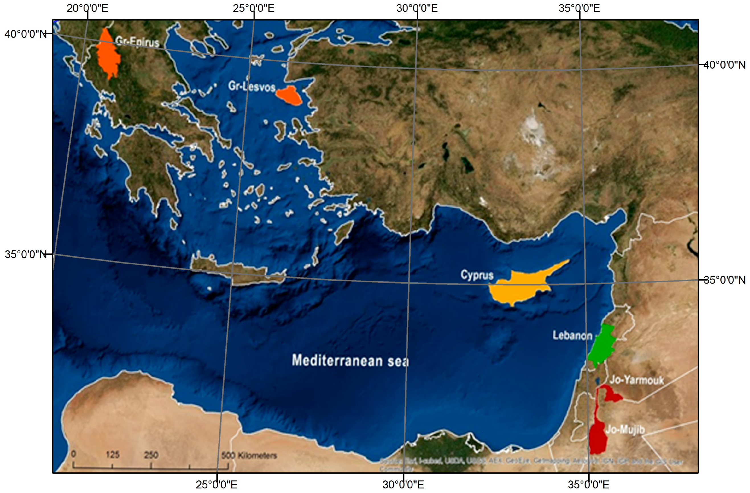
2.1. Study Area-East Mediterranean Basin
- (a)
- Cyprus: the study area includes the whole of the island, the third largest in the Mediterranean. The island is divided into three geomorphological zones, the Troodos Mountain, the Pentadaktylos Range and the Mesaoria plain with rugged morphology and varied geology. The climate is, in general at the drier end of the Mediterranean-type climates. The rural landscape is dominant and usually intermixed with natural elements.
- (b)
- Mujib (Jordan): the study area is located within Madaba and Kerak governorates. The area extends from the Jordan Rift Valley (JRV) escarpment in the west at 420 m below sea level to the central highlands plateau in the east with elevations exceeding 700 m above sea level.
- (c)
- Al Yarmouk (Jordan): the study area is located in the NW part of Jordan. Al Yarmouk catchment area has high relief topography with elevations from about 26 m.b.s.l. to about 1200 m.a.s.l. The catchment comprises of large urban centers (Irbid and Al Ramtha) in addition to extensive agricultural activities (around 50% of the total catchment area).
- (d)
- Epirus (Greece): the study area is predominantly mountainous characterized by significant landscape diversity. High mountains with dense forest cover below 1700 m and alpine meadows at their peaks are traversed by wide cultivated valleys and steep unsettled gorges; cultivated, settled areas and extensive grazed pastures.
- (e)
- Lesvos (Greece): the study area includes the whole of the island, the third largest in the Aegean Sea. Agriculture and tourism are the main economic activities on the island. Approximately 41.3% of the island’s surface is olive plantations, 34% maquis and garrigue, 17% forest, 4.3% other crops, while the remaining land has various uses such as constructions, wetlands, etc.
- (f)
- Lebanon: the study area is approximately 4747.40 km2, c.45% of the total area of the country. It contains 15 cazas that reach an altitudinal range of 1700 m, with exceptions of high peaks in mountainous areas, and low altitudes in deep valleys. Moreover, it encompasses four distinct geomorphological regions, which are: coastal plain, Lebanon mountain range, Bekaa valley, and the Anti-Lebanon mountain range.
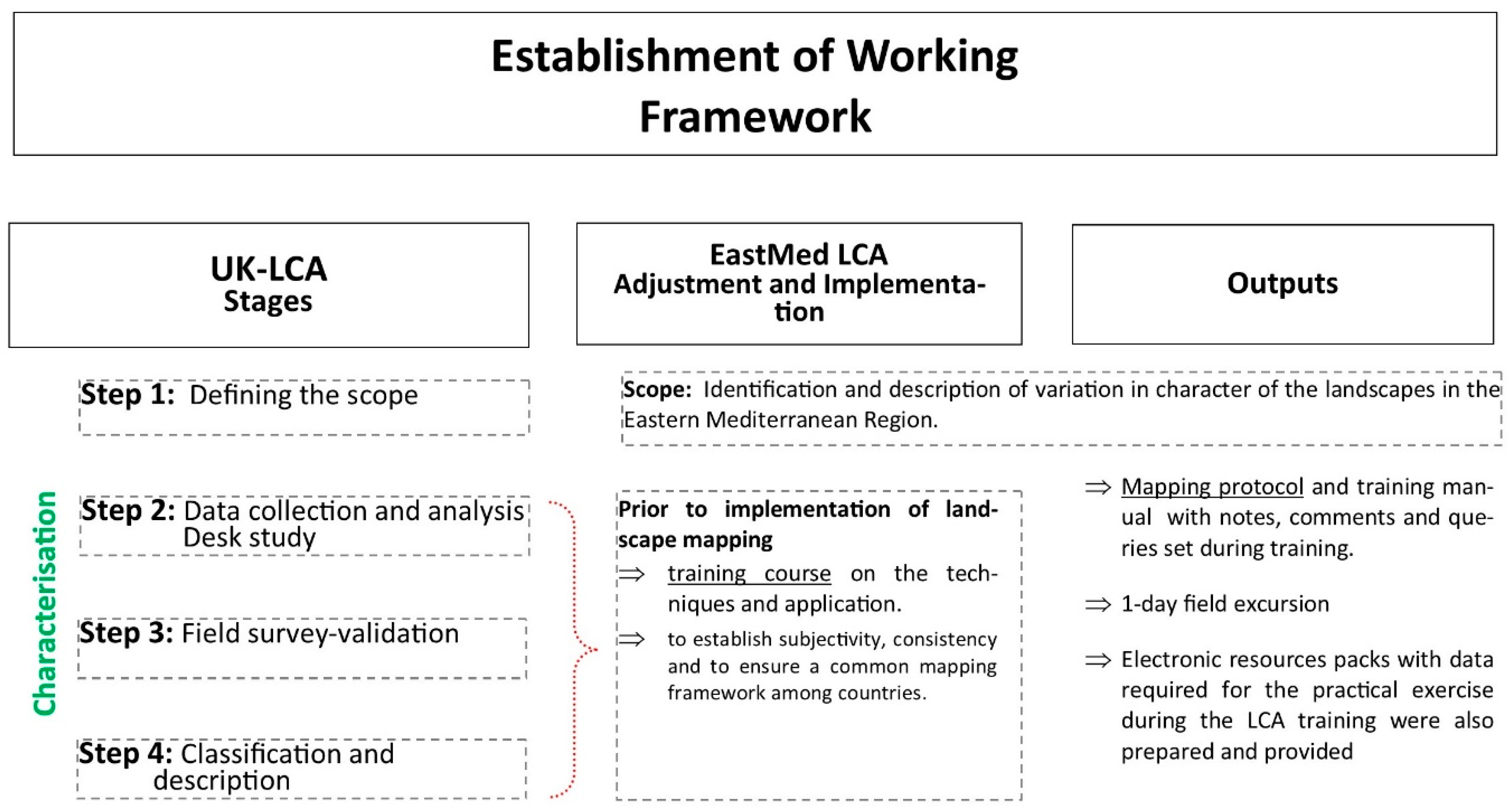
2.2. Landscape Character Mapping
- (A)
- Physical attributes: (i) geomorphology i.e., the inclusion of rugged terrain of hills and mountains, ravines and gorges, as well as plateaus was seen a necessary part of the typology (ii) coasts: MB has a long coast line while 3 out of 6 study areas border the sea, (iii) local distinctness: Fleshing out distinct types present at the national or case study level as described in Section 3.1.
- (B)
- Cultural attributes: (i) Settlement pattern mainly reflected by villages and field pattern (ii) Landuse and land cover: a long history of human activity imprinted on land cover. For example the rangelands, reflecting the pastoral tradition [22,23,24] and shrublands (i.e., maquis or garrigue) also characteristic of the MB were incorporated.
2.3. Landscape Complexity and Diversity
2.4. Statistical Analysis
3. Results
3.1. East Mediterranean Typology
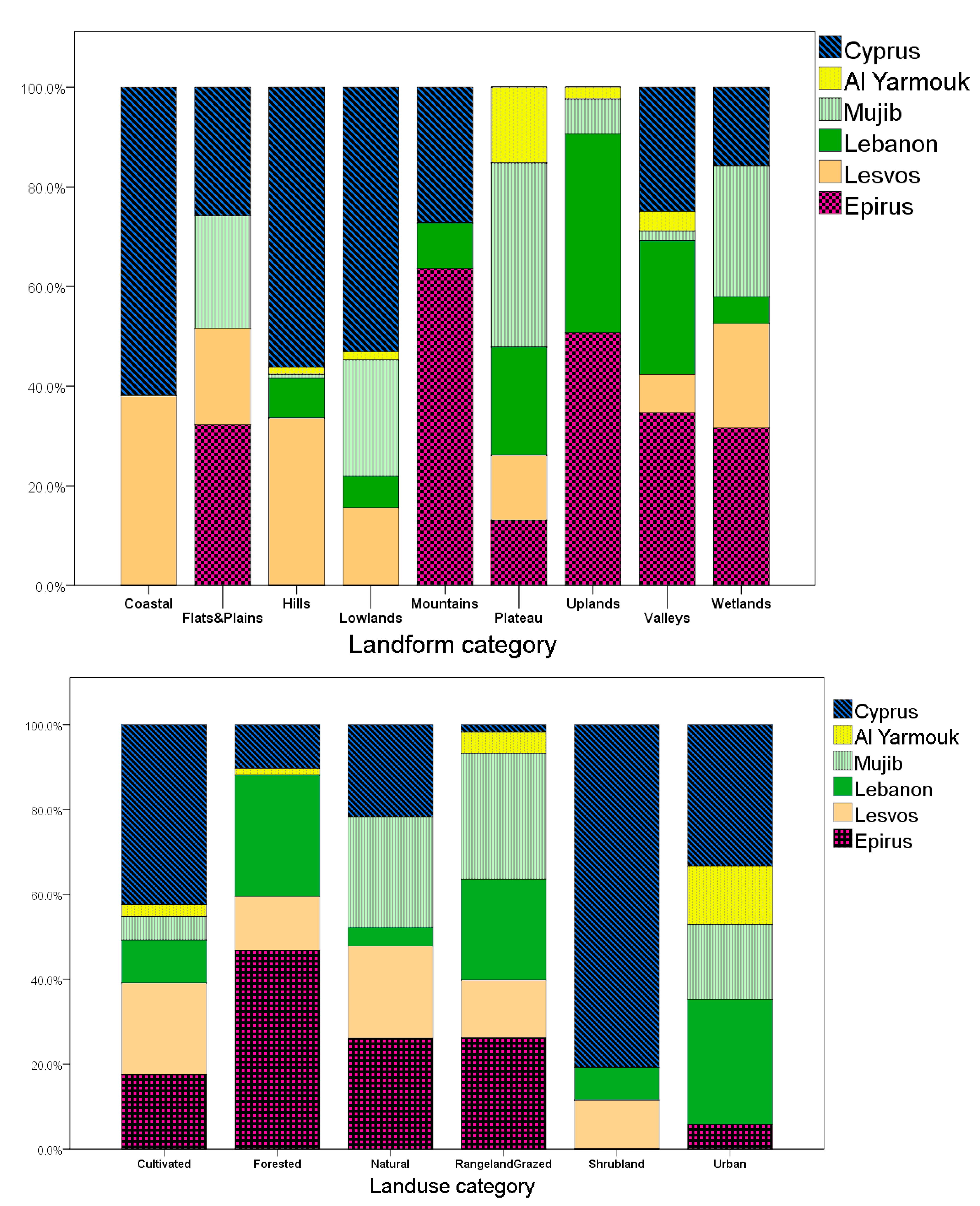
3.2. Landscape Diversity
4. Discussion
5. Conclusions
Acknowledgments
Author Contributions
Conflicts of Interest
Appendix A

| Mediterranean Type | National Types | ||
|---|---|---|---|
| Hills | Hills1 | Settled rangeland hills | Rangeland sparsely settled hills (LEB); The majority are rangelands and cultivated hills while settled hills are minority (ALYAR); Settled rangeland hills (CY) |
| Hills2 | Unsettled forested hills | Forested hills unsettled (LES); Unsettled forested hills (CY) | |
| Hills3 | Settled forested hills | Forested settled hills (LEB); Settled forested hills (CY) | |
| Hills4 | Settled cultivated hills | Cultivated hills sparsely settled (LES); Settled cultivated hills (CY) | |
| Hills5 | Unsettled hill shrublands | Scrubby hills and valleys unsettled (LES); Unsettled hill shrublands (CY) | |
| Hills6 | Unsettled Arid hills sporadically grazed/Arid hills | Arid hills, valleys and lowlands sporadically grazed (or by wild animals) (MUJ); The majority are arid hills while cultivated hills are minority (ALYAR) | |
| Hills7 | Unsettled cultivated hills | Unsettled cultivated hills (CY) | |
| Hills8 | Settled hill shrublands | Settled hills shrublands (CY) | |
| Hills9 | Settled hill with vineyards | Settled hills with vineyards (CY) | |
| Hills10 | Unsettled rangeland hills | Grazed hills and valleys unsettled (LES) | |
| Uplands | Uplands1 | Unsettled forested uplands | Forested Uplands (EPIR); Forested unsettled high uplands (LEB); Forested uplands (Unsettled) (ALYAR) |
| Uplands2 | Settled forested uplands | Forested Uplands (EPIR); Forested settled uplands (LEB); The majority are forested uplands while settled uplands are minority(Settled forested uplands) (ALYAR) | |
| Uplands3 | Settled cultivated uplands | Cultivated Uplands (EPIR); Agricultural settled high uplands (LEB); Agricultural settled uplands (LEB); Sparsely settled, grazed and cultivated uplands (MUJ); The majority are cultivated uplands while settled uplands are minority (ALYAR) | |
| Uplands4 | Unsettled cultivated uplands | Cultivated Uplands (EPIR); | |
| Uplands5 | Settled shrubland uplands | Scrubby sparsely settled high uplands (LEB); | |
| Uplands6 | Unsettled rangeland uplands | Grazed High Uplands (EPIR); Grazed Uplands and Hills (EPIR); Rangelands unsettled high uplands (LEB); Unsettled upland rangeland (MUJ) | |
| Uplands7 | Settled rangeland uplands | Grazed High Uplands (EPIR); Grazed Uplands and Hills (EPIR); Rangelands sparsely settled uplands (LEB) | |
| Plateau | Plateau1 | Unsettled alpine plateaus | Alpine Plateaus (EPIR) |
| Plateau2 | Unsettled forested plateaus | Forested plateaus (LES) | |
| Plateau3 | Settled forested plateaus | Forested plateaus (LES) | |
| Plateau4 | Settled cultivated plateaus | Cultivated Plateaus and Hills (EPIR); Cultivated plateau (LES); Agricultural sparsely settled high plateau (LEB); Agricultural sparsely settled plateau (LEB);Cultivated and rangelands plateaus (settled cultivated plateaus) (ALYAR); Cultivated plateau (settled cultivated plateaus) (ALYAR); Settled and cultivated plateaus (ALYAR); The majority are rangelands and cultivated plateau while settled hills are minority (ALYAR); Settled plateaus, cultivated and mixed agriculture-rangeland (MUJ) | |
| Plateau5 | Unsettled cultivated plateaus | Cultivated Plateaus and Hills (EPIR); Cultivated plateau (LES); | |
| Plateau6 | Unsettled rangeland semi-arid/eroded plateaus | Rangeland unsettled high plateau (LEB); Semi-arid eroded plateau rangelands (MUJ); Semi-arid plateau rangelands (MUJ); Eroded plateau mixed farming and rangeland (MUJ); | |
| Plateau7 | Settled rangeland semi-arid/eroded plateaus | Semi-arid eroded plateau rangelands (MUJ); Semi-arid plateau rangelands (MUJ); Eroded plateau mixed farming and rangeland (MUJ); Rangelands and cultivated plateau (ALYAR) | |
| Plateau8 | Eroded plateau mixed farming | Eroded plateau mixed farming (ALYAR) | |
| Mountains | Mountain1 | Settled forested mountains | Settled mountain forest (CY); Forested Mountains (EPIR) |
| Mountain2 | Unsettled forested mountains | Unsettled mountain forest (CY); Forested Mountains (EPIR) | |
| Mountain3 | Unsettled High (Alpine) mountains | High Mountains (EPIR) | |
| Mountain4 | Settled Alpine mountains | High Mountains (EPIR) | |
| Mountain5 | Settled mountain shrublands | Settled mountain shrublands (CY) | |
| Mountain6 | Unsettled mountain shrublands | Unsettled mountain shrublands (CY) | |
| Mountain7 | Settled cultivated mountains | Settled cultivated mountains (CY) | |
| Mountain8 | Unsettled rangeland mountains | Rangeland unsettled mountainous area (LEB); Grazed Mountains (EPIR) | |
| Mountain9 | Settled rangeland mountains | Grazed Mountains (EPIR) | |
| Coastal | Coastal1 | Settled cultivated coastal alluvial plains | Settled cultivated coastal alluvial plains (CY) |
| Coastal2 | Settled coastal hill shrublands | Settled coastal hill shrublands (CY) | |
| Coastal3 | Unsettled coastal hill shrublands | Unsettled coastal hill shrublands (CY) | |
| Coastal4 | Settled cultivated coastal hills | Settled cultivated coastal hills (CY); Cultivated hills sparsely settled (LES) | |
| Coastal5 | Settled coastal lowland shrublands | Settled coastal lowland shrublands (CY) | |
| Coastal6 | Settled cultivated coastal lowlands | Settled cultivated coastal lowlands (CY); Cultivated hilly lowlands sparsely settled (LES) | |
| Coastal7 | Settled cultivated coastal valley | Settled cultivated coastal valley (CY) | |
| Coastal8 | Unsettled coastal lowland shrublands | Unsettled coastal lowland shrublands (CY) | |
| Coastal9 | Unsettled cultivated coastal lowlands | Unsettled cultivated coastal lowlands (CY); Cultivated hilly lowlands unsettled (LES) | |
| Coastal10 | Coastal dunes | Coastal dunes (CY) | |
| Coastal11 | Unsettled grazed coastal hills | Unsettled Grazed coastal hills (LES) | |
| Coastal12 | Settled cultivated coastal plains | Settled cultivated plains (LES) | |
| Valley | Valley1 | Settled forested valley | Settled forested valley (CY); Forested Valleys (EPIR); Forested sparsely settled valley (LEB) |
| Valley2 | Unsettled forested valley | Forested Valleys (EPIR); Forested unsettled deep valleys (LEB) | |
| Valley3 | Settled cultivated valleys | Settled cultivated valley (CY); Cultivated Valleys (EPIR); Cultivated valleys (LES); Agricultural sparsely settled valley (LEB); Cultivated valley floors and river terraces (ALYAR) | |
| Valley4 | Unsettled cultivated valleys | Unsettled cultivated valley (CY); Cultivated Valleys (EPIR); Cultivated valleys (LES) | |
| Valley5 | Unsettled deep valleys | Unsettled ravine shrublands (CY); Deep Ravines (EPIR); Unsettled deep valleys and ravines (MUJ) | |
| Valley6 | Settled valley rangelands | The majority are valley rangelands while the settled valley are minority (ALYAR) | |
| Lowlands | Lowlands1 | Forested settled lowlands | Forested sparsely settled lowlands (LEB) |
| Coastal5 | Unsettled cultivated lowlands | Unsettled cultivated lowlands (CY); Cultivated hilly lowlands unsettled (LES) | |
| Lowlands3 | Settled cultivated lowlands | Settled cultivated lowlands (CY); Agricultural sparsely settled lowlands (LEB); Cultivated hills lowlands sparsely settled (LES) | |
| Lowlands4 | Unsettled lowland rangelands | Rangelands/lowland/unsettled (ALYAR); Unsettled lowland, hill and valley rangelands, regularly/seasonally grazed (MUJ) | |
| Lowlands5 | Settled cultivated alluvial lowlands | Settled cultivated alluvial lowlands (CY) | |
| Lowlands6 | Unsettled lowland shrublands | Unsettled lowland shrublands (CY) | |
| Wetlands | Wetlands1 | Coastal wetlands | Coastal Wetlands (CY); Coastal wetlands (LES) |
| Wetlands2 | Lakes | Lakes (EPIR) | |
| Wetlands3 | Riverbeds | Riverbeds (EPIR) | |
| Wetlands4 | Water bodies | Water bodies (LEB) | |
| Wetlands5 | Salt flats | Salt flats (MUJ) | |
| Wetlands6 | Dead Sea | Dead Sea (MUJ) | |
| Wetlands7 | Escarpments of the Dead Sea | Escarpments of the Dead Sea (MUJ) | |
| Flats & Plains | Flats&Plains1 | Settled cultivated plains | Settled cultivated plains (MUJ); Settled cultivated plains (LES); Cultivated Plains (EPIR) |
| Flats&Plains2 | Unsettled cultivated plains | Cultivated Plains (EPIR) | |
| Flats&Plains3 | Settled cultivated alluvial plains | Settled cultivated alluvial plains (CY) | |
| Flats&Plains4 | Unsettled cultivated alluvial plains | Unsettled cultivated alluvial plains (CY) | |
| Flats&Plains5 | Unsettled rangeland plains | Unsettled plain rangelands (MUJ) | |
| Urban | Urban | Urban | Urban Areas (EPIR); Urban (CY); Settled plateau (ALYAR); Settled uplands (ALYAR); Artificial settled hills (LEB); (Artificial) Urbanized lowlands (LEB) |
References
- Odum, E.P. Great ideas in ecology for the 1990s. BioScience 1992, 42, 542–545. [Google Scholar] [CrossRef]
- Forman, R.; Godron, M. Landscape Ecology; John Wiley: New York, NY, USA, 1986. [Google Scholar]
- Council of Europe/UNEP & Environmental Centre for Nature Conservation. The Pan-European Biological and Landscape Diversity Strategy. A Vision for Europe’s Natural Heritage; Council of Europe Press: Strasbourg, France, 1996. [Google Scholar]
- Vogiatzakis, I.N.; Pungetti, G.; Mannion, A. (Eds.) Mediterranean Island Landscapes: Natural and Cultural Approaches; Landscape Series; Springer Publishing: New York, NY, USA, 2008; Volume 9. [Google Scholar]
- Grove, A.T.; Rackham, O. The Nature of Mediterranean Europe: An Ecological History; Yale University Press: London, UK, 2001. [Google Scholar]
- Blondel, J.; Aronson, J.; Bodiou, J.-Y.; Boeuf, G. The Mediterranean Region: Biological Diversity in Space and Time; Oxford University Press: Oxford, UK, 2010. [Google Scholar]
- Athanassopoulos, E.F.; Wandsnider, L. (Eds.) Mediterranean Archaeological LandscapesCurrent Issues; University of Pennsylvania Press: Philadelphia, PA, USA, 2004. [Google Scholar]
- Mazzoleni, S.; Di Pasquale, G.; Mulligan, M.; Di Martino, P.; Rego, F. (Eds.) Recent Dynamics of the Mediterranean Vegetation and Landscape; John Wiley & Sons: New York, NY, USA, 2004. [Google Scholar]
- IUCN. Guidelines for Protected Area Management Categories; CNPPA with the assistance of WCMC; IUCN: Gland, Switzerland; Cambridge, UK, 1994. [Google Scholar]
- Vogiatzakis, I.; Papayannis, T.; Mannion, A.M. Political landscapes of Mediterranean islands. In Mediterranean Island Landscapes; Vogiatzakis, I.N., Pungetti, G., Mannion, A.M., Eds.; Springer: New York, NY, USA, 2008; pp. 100–114. [Google Scholar]
- Stanners, D.; Bourdeau, P. Europe’s Environment: The Dobris Assessment; European Environment Agency: Copenhagen, Denmark, 1995. [Google Scholar]
- European Landscape Convention. Available online: https://rm.coe.int/16800805ce (accessed on 19 October 2017).
- Washer, D.; Jongman, R. (Eds.) European Landscapes: Classification, Evaluation and Conservation; Environment Technical Reports; European Environment Agency: Copenhagen, Denmark, 2003. [Google Scholar]
- Jongman, R.H.G.; Bunce, R.G.H.; Metzger, M.J.; Mücher, C.A.; Howard, D.C.; Mateus, V.L. Objectives and applications of a statistical environmental stratification of Europe. Landsc. Ecol. 2006, 21, 409–419. [Google Scholar] [CrossRef]
- Mücher, C.A.; Klijn, J.A.; Wascher, D.M.; Schaminée, J.H.J. A new European Landscape Classification (LANMAP): A transparent, flexible and user-oriented methodology to distinguish landscapes. Ecol. Indic. 2010, 10, 87–103. [Google Scholar] [CrossRef]
- Warnock, S.; Griffiths, G.H. Landscape Characterisation: The Living Landscapes approach in the UK. Landsc. Res. 2015, 40, 261–278. [Google Scholar] [CrossRef]
- Hazeu, G.W.; Metzger, M.J.; Mücher, C.A.; Perez-Soba, M.; Renetzeder, C.H.; Andersen, E. European environmental stratifications and typologies: An overview. Agric. Ecosyst. Environ. 2011, 142, 29–39. [Google Scholar] [CrossRef]
- Brabyn, L. Landscape classification using GIS and national digital databases. Lands. Res. 1996, 21, 277–300. [Google Scholar] [CrossRef]
- Groom, G.; Wascher, D.; Potschin, M.; Haines-Young, R. Landscape character assessments and fellow travellers across Europe: A review. In Landscape Ecology in the Mediterranean: Inside and Outside Approaches; Bunce, R.G.H., Jongman, R.H.G., Eds.; IALE Publication Series: Faro, Portugal, 2006; Volume 3, pp. 227–231. [Google Scholar]
- Vogiatzakis, I.N. Mediterranean experience and practice in Landscape Character Assessment. Ecol. Med. 2011, 37, 17–31. [Google Scholar]
- Meeus, J.H.A. Pan-European landscapes. Landsc. Urban Plan. 1995, 31, 57–79. [Google Scholar] [CrossRef]
- Malek, Ž.; Verburg, P. Mediterranean land systems: Representing diversity and intensity of complex land systems in a dynamic region. Landsc. Urban Plan. 2017, 165, 102–116. [Google Scholar] [CrossRef]
- Le Houerou, H.N. Impact of man and his grazing animals. In Ecosystems of the World 11: Mediterranean Type—Shrublands; Di Castri, F., Goodall, D.W., Sprecht, R.L., Eds.; Elsevier: Amsterdam, Netherlands, 1981. [Google Scholar]
- Papanastasis, V.P.; Chouvardas, D. Application of the state-and-transition approach to conservation management of a grazed Mediterranean landscape in Greece. Israel J. Plant Sci. 2005, 53, 191–202. [Google Scholar] [CrossRef]
- Lang, S.; Tiede, D. vLATE Extension für ArcGIS—Vektorbasiertes Tool zur quantitativen Landschaftsstrukturanalyse. Available online: https://sites.google.com/site/largvlate/gis-tools/v-late (accessed on 19 October 2017).
- McGarigal, K. Fragstats: Spatial Pattern Analysis Program for Categorical Maps; User Manual; University of Massachusetts: Amherst, MA, USA, 2015. [Google Scholar]
- Kent, M. Vegetation Description and Data Analysis: A Practical Approach, 2nd ed.; Wiley: New York, NY, USA, 2012. [Google Scholar]
- Vogiatzakis, I.N.; Zomeni, M.; Mannion, A.M. Characterizing Islandscapes: Conceptual and Methodological Challenges Exemplified in the Mediterranean. Land 2017, 6, 14. [Google Scholar] [CrossRef]
- MacArthur, R.H.; Wilson, E.O. The theory of Island Biogeography; Princeton University: Princeton, NJ, USA, 1967. [Google Scholar]
- Nagendra, H. Opposite trends in response for the Shannon and Simpson indices of landscape diversity. Appl. Geogr. 2002, 22, 175–186. [Google Scholar] [CrossRef]


| Natural and Cultural Features of the Study Areas | Area (km2) | Sources of Information for the Desk Study | |||
|---|---|---|---|---|---|
| Geology | Landform | Landuse—Land Cover | Settlement | ||
| Cyprus: the islands is a global biodiversity hotspot and is located on a bird migratory route. There are 38 terrestrial Sites of Conservation Importance at the EU level (i.e., Natura 2000 sites) while c.60% of its territory comprises high nature value farmlands important for biodiversity support. Cyprus is also rich archaeological sites as well as religious sites (Christian and Muslim). | 9251 | Geological map (1:250,000) | 20 m contours—derived from USGS Global (DEM) | Corine |
|
| Mujib (Jordan): As part of the Jordan, Rift Valley (JRV) the area in along an important global bird migration flyway. It is one of the most remarkable nature and biodiversity areas of interest in Jordan, with one Protected Area and two Special Conservation Areas The area is also known for its cultural and religious value, and is one of the most visited adventure and therapeutic tourism destinations in Jordan. Large part of the Area is a UNESCO Man and the Biosphere Reserve | 4207 | Geological map of Jordan (1:250,000) | Topographic maps (1:50.000) | National Land Cover Map 1:250,000 | Google Earth |
| Topographic Maps | |||||
| Al Yarmouk (Jordan): The area includes a Special Conservation Area, a forest reserve while it is also rich in scenic, historical, and cultural elements, including remains of uninterrupted occupation since the Neolithic Period and the ancient city of Gadara (Umm Quais) | 1390 | Geological map of Jordan (1:250,000) | 30 m DEM (ASTER) Global Digital Elevation Model ver. 2; 30 m contours | National Land Cover Map 1:250,000 | Google Earth |
| Topographic Maps | |||||
| Epirus (Greece): The rich natural heritage of the area, which includes the National Parks of Northern Pindos and Vikos-Aoos (both important nationally for their floristic diversity), is complemented by its significant historic and cultural heritage, characteristically portrayed through the plethora of traditional settlements, stone bridges and footpaths. Vikos-Aoos is a UNESCO Global Geopark and one of the last European stongholds of the brown bear | 3908 | Geological map of Epirus | Topographic map, contours per 50 m (Aster Global DEM) 20 m) | CORINE land-cover (1:250,000), geodata.gov | Google Earth |
| Topographic Maps | |||||
| Lesvos (Greece): Contains 34% surface cover of maquis and garrigue, 17% forest, and important wetlands. The architecture is particularly rich in legacy and styles and showcases cultural influences from the East (Ottoman Empire) and from the West (Europe). Natural and other monuments and historical sites: The Petrified Forest of Sigri and cultural monuments (i.e., the Castle of Sigri). Religious monuments: the Ypsilou Monastery and the Monastery of Pithariou. Archaeological Sites: Fortress of Sigri, Eresos Acropolis, Monastery High, Pithariou Monastery. Traditional settlements: Vatoussa | 1795 | Geological map of Lesvos (1:250,000), UoA | Topographic map, contours per 50 m (1:250,000) UoA | CORINE land-cover (1:250,000), geodata.gov | Ordnance survey map (1:250,000); geodata.gov |
| Lebanon: the study area includes three Man and the Biosphere Reserves, more than 10 nationally designated protected areas and biodiversity hotpspots such as the Lebanon and Anti-Lebanon mountains, as well as Byblos (Jbeil) a World Heritage Site | 4757 | Geological map | 50 m contour maps; Topographic map | Land cover map (1:20,000) | Settlement map |
| Cyprus | Al Yarmouk | Mujib | Lebanon | Lesvos | Epirus | |
|---|---|---|---|---|---|---|
| Cyprus | ||||||
| Al Yarmouk | 0.09 | |||||
| Mujib | 0.04 | 0.46 | ||||
| Lebanon | 0.22 | 0.46 | 0.31 | |||
| Lesvos | 0.46 | 0.13 | 0.12 | 0.17 | ||
| Epirus | 0.20 | 0.34 | 0.23 | 0.42 | 0.16 |
| Total number of LDUs | 617 |
| Total number of LCTs | 69 |
| Classes (categories) based on landform (Total number) | Hills, Valleys, Mountains, Uplands, Plateau, Coastal, Lowlands, Flats and Plains, Wetlands, Urban (10) |
| Classes (categories) based on land use (Total number) | Rangelands and Grazed, Shrubland, Forested, Cultivated, Vineyards, Arid (6) |
| Most common category based on landform (No of LDUs) | Hills (137) |
| Most common category based on land use (No of LDUs) | Urban (45), Shrubland (41) |
| Most common LCT | Settled cultivated/agricultural lowlands |
| Rare types (No of LDUs) | Escarpments of the Dead Sea (1), Dead Sea (1), Salt flats (3), Water bodies (1), River beds (4), Forested sparsely settled lowlands (1), Unsettled Forested Plateaus (1), Settled Forested plateaus (1), Eroded plateau mixed farming (1), Settled High (Alpine) Mountains (1), Unsettled mountain shrublands (1), Settled cultivated coastal valley (1), Coastal dunes (1), Settled rangelands valley (1), Forested sparsely settled lowlands (1), Unsettled lowland shrublands (1), Unsettled cultivated alluvial plains (1), Unsettled plain rangelands (1). |
| Area Analysis | Lesvos | Epirus | Mujib | Al Yarmouk | Lebanon | Cyprus |
|---|---|---|---|---|---|---|
| Total Area in km2 | 1795 | 3908 | 3800 | 1390 | 4757 | 9251 |
| Number of LDUs | 95 | 151 | 55 | 21 | 97 | 198 |
| Diversity Analysis | ||||||
| Landscape Character Type Richness (LCTR) | 11 | 16 | 23 | 16 | 21 | 35 |
| Shannon’s Diversity (SHDI) | 2.152 | 2.28 | 2.601 | 2.321 | 2.742 | 2.717 |
| Shannon’s Evenness (SHEI) | 0.897 | 0.822 | 0.83 | 0.837 | 0.901 | 0.764 |
| Dominance | 0.246 | 0.493 | 0.534 | 0.452 | 0.303 | 0.838 |
| Form Analysis | ||||||
| Mean Shape Index (MSI) | 1.95 | 1.747 | 2.215 | 2.203 | 2.263 | 2.073 |
| Cyprus | Al Yarmouk | Mujib | Lebanon | Lesvos | Epirus | |
|---|---|---|---|---|---|---|
| K-Independent test between LDUs per site and Landform categories | ||||||
| Chi-Square | 32.159 | 19.194 | 15.613 | 28.741 | 10.881 | 33.223 |
| df | 9 | 9 | 9 | 9 | 9 | 9 |
| Asymp. Sig. | 0.000 | 0.024 | 0.075 | 0.001 | 0.284 | 0.000 |
| K-Independent test between LDUs per site and Landuse categories | ||||||
| Chi-Square | 25.578 | 17.659 | 18.620 | 12.416 | 10.566 | 14.598 |
| df | 5 | 5 | 5 | 5 | 5 | 5 |
| Asymp. Sig. | 0.000 | 0.003 | 0.002 | 0.030 | 0.061 | 0.012 |
| Linear Regressions (log to log) | R2 | F | P | |||
| LDUs against area | 0.55 | 4.70 | 0.08 | |||
| Landscape types against area | 0.73 | 10.96 | 0.03 * | |||
| SHDI against area | 0.61 | 6.33 | 0.07 | |||
| SHEI against area | 0.25 | 1.31 | 0.31 | |||
© 2017 by the authors. Licensee MDPI, Basel, Switzerland. This article is an open access article distributed under the terms and conditions of the Creative Commons Attribution (CC BY) license (http://creativecommons.org/licenses/by/4.0/).
Share and Cite
Vogiatzakis, I.N.; Manolaki, P. Investigating the Diversity and Variability of Eastern Mediterranean Landscapes. Land 2017, 6, 71. https://doi.org/10.3390/land6040071
Vogiatzakis IN, Manolaki P. Investigating the Diversity and Variability of Eastern Mediterranean Landscapes. Land. 2017; 6(4):71. https://doi.org/10.3390/land6040071
Chicago/Turabian StyleVogiatzakis, Ioannis N., and Paraskevi Manolaki. 2017. "Investigating the Diversity and Variability of Eastern Mediterranean Landscapes" Land 6, no. 4: 71. https://doi.org/10.3390/land6040071
APA StyleVogiatzakis, I. N., & Manolaki, P. (2017). Investigating the Diversity and Variability of Eastern Mediterranean Landscapes. Land, 6(4), 71. https://doi.org/10.3390/land6040071