Abstract
In historical regional cropland reconstruction in floodplains and delta areas, changes in the river system and the historical distribution of settlements are important to the spatial–temporal dynamic process of historical land reclamation. This paper takes the Yellow River Delta as the research area, combines historical data with field investigation, and analyzes the influence of river system change and delta formation on settlement establishment and land reclamation. The results revealed the following. (1) The development timing of the Yellow River determines the order of deposited land by old river courses and the settlement or resettlement process of the village. Since 1855, approximately 90% of new villages have been located within the 1–5 km buffer of the Yellow River channels. Two peak tides for village establishment along the Yellow River corresponded to the fluvial periods and the 20 ± 10 yr after the river silted out. It took over 100 years for the cultivation range to advance 5 km from the coastline of 1820 to the sea for the lengthy desalination and subsequent freshwater-driven dilution of the newly deposited land. (2) It is necessary to introduce the locations of the settlements, distance from the river courses, and coastline change to the cropland distribution model by setting parameters for different buffer zone distances. This paper provides data and theoretical parameters for cropland construction in the Yellow River Delta suitable for the floodplains and delta areas. The relevant findings can provide valuable references for land use policy formulation, agricultural development planning, and management practices in delta regions.
1. Introduction
A delta is a transition zone between land and sea where rivers enter the sea or lake, and due to the decreasing gradient of the riverbed, the flow of water branches off, kinetic energy weakens, and sediment transported by the river is deposited at the mouth to form a fan-shaped deposition (i.e., an alluvial plain with an estuarine origin) [1]. The offshore area is affected by the ocean and is easily invaded by the tide, and the degree of salinization of the soil, which must be resistant to land reclamation, is high [2]. On the other hand, the convenience of irrigation provided by the delta’s larger rivers, the fertility of river sediments, and the expansion of land caused by silting of the estuary can also be seen as the continuing material power of deltaic agricultural development [3]. This is why many of the world’s major river deltas can develop into excellent agricultural areas and even become the most developed, densely populated, and economically and culturally advanced areas in the country, being affected by river changes and the formation of the delta [4,5,6,7].
Rivers in the delta feed the coastal croplands, and riverine changes are often accompanied by the regeneration, destruction, and spatial patterning change of the croplands [8,9,10]. Changes in the delta shoreline also affect cropland distribution in different historical periods. By being relatively consistent with the spatial pattern of real cropland distribution, the paths of settlement expansion accompanied by reclamation often reflect the spatial–temporal process of historical land reclamation.
Research on historical regional cropland reconstruction usually constructs the land suitability index based on the relationship between the distribution of modern croplands and natural geographic factors. Natural factors affecting suitability for agriculture, such as temperature, elevation, and distance from the river or coast, are considered. Based on the principle of priority in the distribution to grids with high suitability for reclamation, cropland area data on the historic administrative unit are gridded to provide input parameters with higher spatial resolutions and address the needs of the climate and carbon budget for simulations [11,12,13,14,15,16,17,18,19,20]. This principle of grid allocation, however, requires special caution in reconstructing historical croplands in floodplains and delta regions, which are largely affected by river network changes with drastic environmental changes. Due to the instability of river flow paths and coastlines and their impact on cropland distribution, static natural suitability constructed solely by modern geographic indicators cannot accurately deduce the spatial–temporal dynamic process of historical land reclamation.
As Fang et al. [21] proposed, land suitability only provides one kind of possibility for reclamation, and the actual reclamation process does not necessarily completely follow the natural land suitability from high to low. The choice of a starting point for cropland reclamation and the process of spatial expansion of croplands is subject to historical path dependence. This means that aside from the natural suitability, both the limitation of the available cultivation scope by river channels and coastlines and settlement as an important indicator reflecting the time-sequential change in historic reclamation are also factors that cannot be ignored in the reconstruction of historical cropland distribution in the floodplains and delta areas.
Currently, some researchers have considered the river course, channel network, coastline change, and settlement index in cropland gridding reconstruction in different regions and at different scales. Zhang and Liu [22] demonstrated that in reconstructing cropland patterns in Xinjiang’s Manas River basin during the late Qing and early Republican periods, the channel networks (main and tributary rivers) reconstructed from 1911 historical maps served as crucial parameters for establishing river buffer zones to allocate cropland areas. When reconstructing the cropland changes in the southern catchment of the upper reaches of the Daqing River over the last 300 years, Li et al. [15] found that although a river channel change would result in the flooding of agricultural land, it increased the river-silted land, which can be called a benefit of silt land. He et al. [23] considered coastal changes in the Song Dynasty, Yuan Dynasty, Ming Dynasty, Qing Dynasty, and modern dynasties when reconstructing China’s gridded croplands in the past millennium. Wu et al. [24] conducted a case study on gridding croplands along the Shangjing Road of the Liao Dynasty and Jilin Province in the past 300 years on the basis of the settlement density method. By combining natural suitability with the historical time-sequential change in reclamation, Zhang et al. [25] used the method of attracting radius of historic urban settlements to reconstruct the spatial pattern of historical cultivated land in Germany and France, which was corrected by natural suitability. The relationship between the settlement distribution and riverbeds is also reflected in some existing studies. Zhao [26] reconstructed the cropland distribution and its change in the Hehuang Valley during the Ming Dynasty using settlement factors and found that fluvial-alluvial plains were the areas with the highest-density settlements in the process of development. Li [27] drew the conclusion that the development of Zhuxian Town was based on the opening of the Jialu River as a turning point by studying place names. Xian [28] summarized the characteristics of the rise of Lanzhou as a ferry and military fortress and its development along the course of the river. However, although the above studies considered the influence of river systems on agricultural reclamation and adopted indicators of ancient river systems, ancient coastlines, and settlements in the gridding allocation model, there are still too few examples, or they are unclear in terms of the historical spatial relationship between them and how to indicate the cropland distribution.
According to the formation history of the Yellow River Delta (YRD) and Yellow River channel change, we combined with gazetteer data and maps of ancient coastal and river channel changes and explored the spatiotemporal evolution of the settlement distribution in the YRD and its driving factors [29]. This study will further investigate the impact of changes in the river system on the reconstruction of a cultivated land grid and propose a cultivated land distribution model applicable to the YRD. This study investigates the sample points of different scaled settlements on different flow paths during the different periods in the YRD, with the purpose of attempting to obtain a method for optimizing the gridding allocation of cropland area data in administrative units in such regions by analyzing the relationship between the change in the river system of the YRD and settlement distribution, especially considering the changes in settlement distributions around old and new river channels before and after diversion of the river, differences in settlement distributions between coastlines of different periods, and so on. This is useful for a further cropland gridding reconstruction model appropriate for the delta region.
2. Study Area
In this paper, we focus on the area of the modern Yellow River Delta, which was formed in 1855 when the Yellow River breached through Tongwaxiang in Henan Province and took the Daqing River into the sea. The contemporary Yellow River Delta region has Ninghai in Kenli District, Dongying City, Shandong Province as its highest point, from the estuary of the Taoer River in the north to the tributary estuary in the south, which is adjacent to Bohai Bay to the north and Laizhou Bay to the east (Figure 1). It has a total land area of approximately 5400 square kilometers, located at 37°30′ N–38°40′ N, 118°00′ E–119°30′ E.
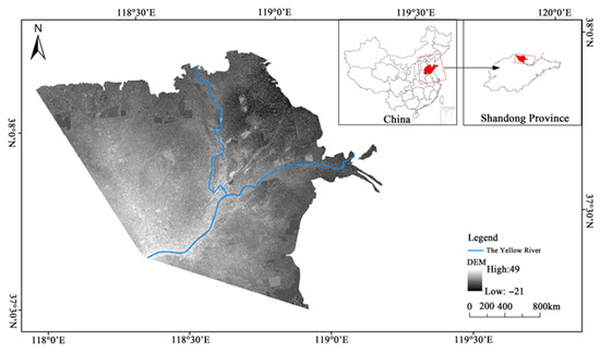
Figure 1.
Schematic of the Yellow River Delta (source: Liu et al. [29]).
Since ancient times, the Yellow River has been known as “one Dan (a unit of volume in ancient China) of water, six Dous (a unit of volume in ancient China, 1 Dan equals to 10 Dou) of sand” and “good at silting, good at bursting, and good at migrating” [30,31]. Because of the Yellow River’s high sediment load and a large amount of sediment transportation per year, the sediments delivered by the Yellow River are deposited in the shelf sea close to the lower reaches and estuary. Each year, the estuary extends to the sea, the riverbed continues to rise, the gradient of the channel gradually decreases, the base level of estuarine erosion gradually increases, and the capacity for sediment and flood discharge decreases year by year. Once the deposition reaches a certain critical value, the river tail changes the route, and an alternative pathway forms that leads the river into the sea [32,33]. The Yellow River’s 1855 breach at Tongwaxiang redirected its course, forming the modern delta’s framework and triggering large-scale migration and land reclamation. After the 1887 Zhengzhou breach, the Qing government strengthened dike construction. During the Republican era (1912–1949), warfare led to water conservancy deterioration. Following the nation’s founding, systematic governance projects were implemented, progressively optimizing the estuary’s sediment deposition patterns. Since the Yellow River diverted to Shandong in 1855, the tail channel has moved frequently to the north and south of the river. There were six large-scale natural diversions in 1889, 1897, 1904, 1926, 1929, and 1934 and four artificial diversions in 1953, 1964, 1976, and 1996 [29]. In addition, there are several distributary channels and artificial canals used for flood control, flood discharge, and drainage. Between these diversions, the lobes corresponding to each flow path were newly born, developed, expanded, and evolved such that the coast was greatly pushed out to sea, the land area continuously expanded, and the geomorphological environment experienced a major change. While the Yellow River sediments are rich in fertility, they are considered good for curing the saline-alkaline soils in the delta. Once silted up to a certain altitude, the land has the necessary conditions for agriculture, making the new silted land in the coastal area suitable for reclamation. The old routes’ siltation finished after the diversion, the large area of land submerged by the bursting and overflowing was improved, and the agricultural potential is enormous. The large area of land silted up by frequent diversions at the tail end of the Yellow River has just become a breakthrough in relieving the pressure of agricultural production in the delta and even in the whole Shandong area. Humans compete for land from old rivers and new river beaches, and the scope for rehabilitation is expanding. To date, the Yellow River Delta has transformed from an uncultivated and uninhabited beach to a thriving scene with numerous villages and large amounts of cultivated land which occupies about 50% of the total land area [34,35].
3. Materials and Methods
3.1. Data Sources
3.1.1. Channel Data on the Lower Yellow River Since 1855
Vector data for the lower Yellow River from 1855 to the present were obtained from the Lower Yellow River 1:1,000,000 Main Channel Changes Database (1855–2005) published by the National Earth System Science Data Center of China (http://www.geodata.cn), a national platform for the basic conditions of science and technology. It has a total of 11 periods of information on the change in the channels of the Yellow River, including 1855–1889, 1889–1897, 1897–1904, 1904–1926, 1926–1929, 1929–1934, 1934–1953, 1953–1964, 1964–1976, 1976–1996, and 1996–2005.
3.1.2. Data on the Coastlines of the Yellow River Delta
The coastline of the Yellow River delta in 1820 came from the China Historical Geographic Information System (CHGIS) (https://sites.fas.harvard.edu/~chgis/, accessed on 1 April 2025, Harvard University, Cambridge, MA, USA). The coastline of 1954 was obtained by geo-referencing and vectoring “The channel change map of Yellow River estuary delta since 1855” in the book Chinese Historical Physical Geography [36], and the modern shoreline data were extracted from the 1:4,000,000 administrative division map of China from the National Basic Geographic Information Center (https://www.webmap.cn).
3.1.3. Data on Historical Settlements and Place Names
Data on the place names and village construction times of rural settlements in the Yellow River Delta collected in this paper were derived from the Gazetteer of Dongying City, Shandong Province [37], Dongying District Annals [38], Kenli County Annals [39], Kenli County Annals (1986–2002) [40], Lijin County Annals [41], Hekou District Annals [42], Zhanhua County Annals [43] and Zhanhua County Annals [44], and other documents. The coordinates of the village were taken from a Baidu map (http://api.map.baidu.com/lbsapi/getpoint/index.html/accessed on 1 April 2025, Baidu Company, Beijing, China). Village coordinate data were extracted from the Baidu map using the coordinate system on the website (http://api.map.baidu.com/lbsapi/getpoint/index.html/accessed on 1 April 2025, Baidu Company, Beijing, China).
3.2. Research Methods
3.2.1. Field Investigation of Settlements and Surrounding Reclamation Along Each Old Route of the Yellow River
In order to further investigate the depositional process of the Yellow River Delta and its impact on the evolution of historical settlements and land reclamation, a field investigation was conducted in Dongying City, Shandong Province from 17 June to 20 June 2021 based on the collected flow paths of the Yellow River, GIS data along the shore, and data from the delta villages.
The layout of the sample sites and routes was based on three principles: (1) covering the major reclamation areas of Lijin and Kenli District as well as several old flow paths of the Yellow River to study the development history of agriculture in the delta; (2) the sampling points and survey routes can span the delta both transversely and vertically to closely observe the settlements and land use situations near the old routes and coastlines in each period; and (3) involving modern hydraulic engineering and Yellow River facilities to understand the inseparable relationship between the modern Yellow River and the agricultural economic development of Dongying City. Table 1 and Figure 2 show the specific survey paths. Coupled with the literature and collected data on the Yellow River regarding water conservancy, river tails, shoreline changes, historic settlements, and land use, the current land use status of historic reclamation sites in some local chronicles involved in this study was investigated, which provided insight into the relationship between the formation of the Yellow River Delta and the distribution of settlements and river changes.

Table 1.
List of the routes of field investigation in Dongying in 2021, Shandong Province.
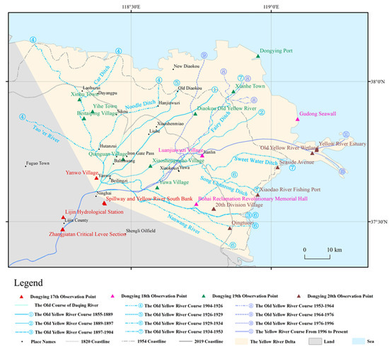
Figure 2.
Study site map of the river system and coastlines of the Yellow River Delta (source: Liu et al. [29]).
Previously, to investigate the spatial distribution characteristics of newly established villages in the Yellow River Delta and examine the relationship between the number of new villages and the active periods of different river channels, we calculated the number of newly established villages during each channel’s active period [29]. The results show that villages established during active periods of different Yellow River channels were predominantly concentrated along active channels and near abandoned silted channels. The locations of these delta settlements reflect the spatial pathways of land reclamation. By referencing toponymic data and county-level historical records, we determined the establishment times of villages in the Yellow River Delta region, using village emergence dates as indicators of agricultural suitability and land reclamation timing.
3.2.2. Buffering Analysis of Channels and Coastlines
To explore the relationship between delta settlement distribution and the changes in the Yellow River channel, multi-ring buffer zone analysis was conducted on the old Yellow River channels in the Yellow River Delta using ArcGIS 10.2. First, the geographical information of the Yellow River Delta and the vector data of the old Yellow River channels were imported into ArcMap 10.2, and the coordinate systems were unified. Then, through the “Buffer Analysis” tool within the Neighborhood Analysis toolset, buffer distances of 1 km, 3 km, and 5 km were set for the vector data of the old Yellow River channels. Eventually, the buffer ranges and shapes of the generated data were obtained. The temporal characteristics of village formation in each period along the former channels of the Yellow River are discussed with the river as the unit of classification. Except for 15 villages which we did not have the exact time of construction of the village for, a total of 607 villages from this study were included in the statistical analysis.
The selection of 1 km, 3 km, and 5 km as search radii was primarily based on the following rationale. First, kernel density analysis demonstrated that these three radii (1 km, 3 km, and 5 km) could most clearly reveal the spatial distribution patterns of settlements with optimal cartographic representation. Second, research by [45] confirmed that within the 0–5 km range, soil salinity and plant biomass showed significant positive and negative correlations with distance from the Yellow River, respectively, precisely reflecting the actual boundary of influence of the Yellow River on surrounding agricultural settlement distribution. Furthermore, the 5 km buffer standard has been validated in studies on other watersheds (e.g., the Manas River in Xinjiang) [22], demonstrating the cross-regional applicability of this scale. Therefore, after comprehensive consideration of cartographic effectiveness, ecological indicator correlations, and cross-regional comparability, this study ultimately adopted 5 km as the standard buffer distance.
On the basis of the 1820 coastline, the 5 km and 10 km radii were extended seaward as buffers. Coupled with the 1954 and 2019 shoreline, four strips stretching from land to sea were eventually formed. The mean establishment times of villages in the four strip areas were calculated as the approximate time when the soil’s physical and chemical properties in the four coastal areas transferred so that land reclamation could take place. As a result of the unequal expansion of villages in the Yellow River Delta from land to sea, the tail of the Yellow River oscillates regularly from southeast to northwest with the former Tiemenguan Road (Old Course 1) as its axis, and thus villages continue to grow along the new and old courses of the Yellow River, with the lobes being reborn. For the outer part of the 1820 coast, former route 4, former route 7, and former route 8 have the newer settlements. Consequently, for the 5 km and 10 km shoreline buffers of 1820, with the Tiemenguan ancient road (Old Course 1) as an axis, the mean times of settlement establishment in the northwestern (Old Course 4) and southeastern (Old Course 7, 8) were computed, respectively. The average settlement time of a village was approximated as the beginning of intensive agricultural production. For the 1954 and modern coasts, the eastern and western regions were no longer divided. The technical roadmap is presented in Figure 3.
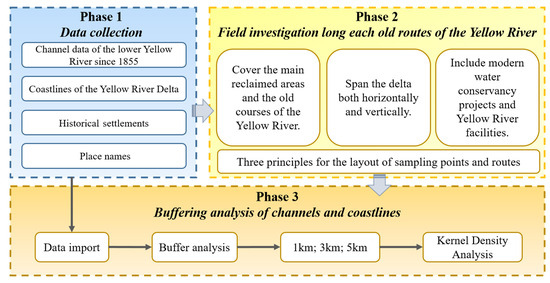
Figure 3.
Technical roadmap.
4. Results
4.1. Relationship Between Settlement Distribution and Channel Changes in the Yellow River
According to the statistics of the distribution of new villages in the buffer zone of the Yellow River (as shown in Table 2 and Figure 4), about 90% of the new villages (547) have been located in the buffer zone of the Yellow River since 1855, of which 236 villages are located in the 1 km buffer zone, accounting for 43% of the total number of villages in the buffer zone. There are 238 villages located in the 1–3 km buffer zone, accounting for 44% of the total number of villages in the buffer zone, and there are 73 villages in the 3–5 km buffer zone, accounting for 13% of the total number of villages in the buffer zone.
Table 2.
The statistical number of new villages along the old courses of the Yellow River (taking 10a as the statistical period) *.
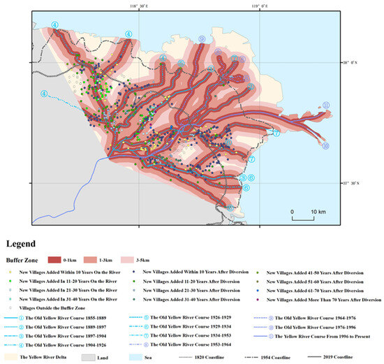
Figure 4.
The distribution of new villages within the buffer zones of different courses of the Yellow River.
Based on statistics from new villages every 10 years for 70 years after each old Yellow River channel was formed (Figure 5), with the exception of the Diaokou River Course (Old Course 9) from 1964 to 1976, the Qingshuigou River Course (Old Course 10) from 1976 to 1996, and the absence of new villages along the present channel of the Yellow River, using the next Yellow River diversion as a node, there will be two adjacent climaxes of village establishment along each course path. The key results are the following. (1) In the first, second, third, and eighth courses of the rivers, the first peak of village establishment corresponded to the running period of the river. During the river running period from the first to eighth Yellow River courses in the delta, 36, 15, 7, 53, 0, 3, 17, and 3 new villages were added along the coast, making up 49%, 32%, 20%, 27%, 0%, 5%, 18%, and 43% of the total number of villages along the corresponding river courses, respectively. (2) The second climax of village establishment took place in the first, second, third, fourth, fifth, sixth, seventh, and eighth flow paths, and the range of times was about 20 ± 10 years after the silted land was formed. Rerouting of the Yellow River exhausts the river as a result, which often results in a second climax of village establishment along the river. (3) The running timing of each flow path determined the order of birth and extension of deltaic lobes and the sequence of silting of rivers in the land, as well as the process of reclamation of immigrants and settlement of villages. (4) Following the second climax of village establishment, there were a few new villages near each of the flow paths.
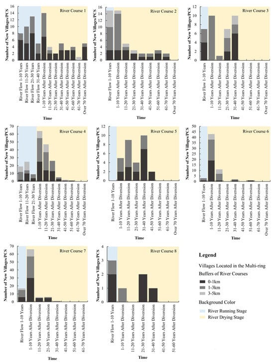
Figure 5.
Statistics of newly added villages every 10 years for the 70 years after the formation of each old Yellow River route.
4.2. The Positional Relationship Between Settlement Distribution and Coastline Changes in the Yellow River Delta
The agricultural exploitation times of the four band areas were divided according to the coastlines and their corresponding buffer zones (Table 3 and Figure 6), with the 5 km coastal buffer in 1820, of which the land to the northwest was reclaimed in a wide area from about 1925, and agricultural production in the southeast, which gradually increased in size around 1953, later than the western region by nearly 30 years. In 1820, the agricultural development in the northwest and southeast of the 5–10 km buffer zone of the coastline entered a good situation around 1932 and 1959, respectively. It is possible that the difference between the eastern and western lands is related to the order of the Yellow River tail shifting. Around the 1960s, the cropland area in the Yellow River Delta was further advanced to the 1954 coastline, and further advances to the sea took place after the 1980s. Due to the development of Gudong oilfields and wetland protection projects, the coastal areas of Dongying are currently dominated by an intertidal zone, meadows, oilfield construction land, artificial waters for aquaculture, and solar salt.
Table 3.
Agricultural exploitation times of four belts according to coastlines and their corresponding buffer zones for each stage (unit: years).
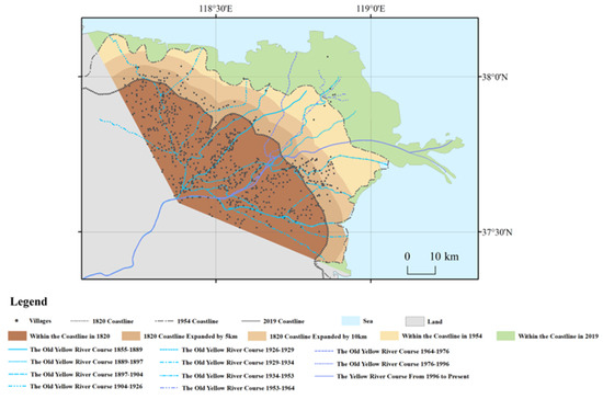
Figure 6.
The positional relationship between the distribution of villages and coastal changes in the YRD since 1855.
With the rate of expansion of cropland into the ocean since 1820, it took over 100 years for cropland reclamation to progress 5 km from the coast to the sea, reflecting the fact that natural desalination and removal of alkali from new land deposited in the delta is a lengthy process. This may also relate to the extensive and underdeveloped agricultural technology at this time in the absence of effective and reasonable government planning for the new silts and in the face of rampant banditry [46]. Within 10 years, the appropriate reclamation area for the Yellow River Delta continued to advance 5 km seaward, and in the eastern portion, it took about another 5 years and 20 years to expand further to coastline of 1954 and the present coastline, respectively. At this point, although the speed of expansion was rapid, the number of villages was sparse. Although missing data in some villages would cause some errors, the assessment of both the settlement expansion patterns and the subsequent land reclamation suitability in the Yellow River Delta’s new sedimentary zones could be compromised by data gaps, leading to potential underestimation of these processes. But the results of the field survey indicate that the reclamation conditions embodied by the settlement scale and soil quality in the region within the coastline in 1820 were indeed the best conditions in the delta. During the independent peasant economy period of feudal society, reclamation households with limited agricultural technology had to take this as the best choice for settling in this region.
5. Discussion
Firstly, the environmental changes in the Yellow River Delta region, such as climate change, rising sea levels, river erosion, and sedimentation, will all have profound impacts on agricultural land distribution, as has been documented in other deltaic regions worldwide. (e.g., the Mekong Delta [47]; the Mississippi Delta [48]). According to the above results on the influence of river systems and coast changes on settlement distributions, attention must be paid to factors carrying historical information when further performing historical cropland gridding in the Yellow River Delta, such as changes in village and cropland distributions with river channel changes and the limitation of the position of the coast in the reclaimed area. Since the Yellow River changed its course to Shandong in 1855, it has formed the current main channel and 10 former channels within the delta. Different historical periods of river courses have varied impacts on sedimentation levels. Village and farmland distributions have also continuously changed with the shifting river channels and coastline [49]. Only using the cropland allocation model based on the modern distribution of croplands and modern natural factors is not applicable in the delta region, where the tail swings frequently.
Second, land reclamation in the historical agricultural society was often accompanied by the birth of rural settlements. Through the investigation of settlement growth in the river buffer zone in this study and the delay in deposition of the original river sediment to form better reclamation conditions after the river’s diversion, some parameters in the gridding allocation model of croplands can be set. For example, it can be set that the croplands are preferentially allocated within 3 km of the river buffer zone, followed by a buffer zone of 3–5 km. There is still potential for reclamation around the former river channel within 70 years after a river diversion, but the most likely or best period of reclamation may be about 20–30 years after diversion. The extent of cropland expansion to the coast is constrained by the coastline at that time. The intrusion of seawater causing salinization limited the expansion of farmlands toward the coast to the extent of the coastline at that time [50]. For example, this study shows that it took over 100 years for cropland reclamation from 5 km from the coastline of 1820 to the sea to occur, reflecting the process of land siltation and natural desalination over the past 100 years. These relevant parameters, based on the cases provided in this study, would contribute to improving the accuracy of reconstruction results.
Finally, today’s beaches and coastal areas may have been reclaimed once but abandoned. For example, many naturally suitable farmlands have been destroyed by land reforms caused by tourism development and rapid urbanization [51,52]. Due to the lack of historical settlement data, especially in early historical periods, the distribution information of some villages and farmlands may be incomplete. Only relying on existing village information for gridding reconstruction of croplands in the delta region would cause unignored errors. Especially in areas along older river courses where village data are missing, although we increased the probability of village or cropland distributions by setting buffers at different distances, these methods may still not fully compensate for the uncertainties caused by data gaps.
HYDE3.2 is currently the most widely used global cropland coverage dataset, but the reconstruction accuracy of the regional scale areas is not sensitive enough. For example, significant overestimations of grassland areas and their distribution in the Qinghai-Tibet Area [15], as well as significant underestimations of cropland areas in the central and southern regions of Taiyuan since the Qing Dynasty [35], overestimations of the total cropland area in Norway’s Scandinavia region, and uncertainties in spatial patterns resulting from allocation methods, have led to uncertainties in cropland reconstruction [53]. These uncertainties will impact global carbon budgets [54], nitrogen budgets [55], species assessments, and environmental evaluations [56]. In the case of the Yellow River Delta, more arable land in HYDE3.2 was allocated to modern coast areas and rivers near these regions while ignoring the historical channel changes of the Yellow River and the moving of the coastline. Our gridded allocation method incorporates settlement locations, distances from river channels, and coastline changes into the cropland distribution model by setting buffer zone parameters, making it more historically accurate. This approach is applicable not only to the Yellow River Delta but also to other deltas and river regions with similar characteristics. For example, the Mississippi River Delta has experienced frequent river channel shifts and coastline changes [48], while the Ganges-Brahmaputra Delta is heavily influenced by monsoons, leading to complex sedimentation processes [57].
The expansion of agriculture in floodplains, while enhancing productivity, has also imposed significant environmental pressures on local ecosystems. For instance, the reclamation and conversion of wetlands have led to the loss of critical habitats, disrupting biodiversity [58]. Additionally, excessive reclamation and improper irrigation management have exacerbated soil degradation and salinization, reducing the ecological recovery capacity of the land [59]. The extensive extraction of water resources and river diversion have also altered regional hydrological cycles, further threatening the sustainability of ecosystems [57]. Therefore, when setting parameters for the gridded allocation model of croplands, it is essential to not only consider historical reclamation conditions but also evaluate the potential impacts of agricultural expansion on ecosystem functions to ensure sustainable land management. In future land management practices, a balance must be struck between agricultural development and ecological conservation to achieve sustainable development in delta regions.
6. Conclusions
This study provided both data and theoretical support for gridding reconstruction of historical cropland in the Yellow River Delta. The key results are as follows.
- (1)
- Since 1855, approximately 90% of new villages have been located within the 1–5 km buffer of the Yellow River channels, which the number of villages in the 1 km and 1–3 km buffers representing 87% of the total number of villages within the buffer area. There are two peak tides for village establishment along the Yellow River, corresponding to the fluvial period and the 20 ± 10 yr after the river silted out. The chronological order of the formation of various river courses of the Yellow River determines the sequence of the birth and extension of delta lobes, as well as the order in which the riverbeds are silted up to form land. At the same time, it also determines the progress of immigrants reclaiming wastelands and the establishment of villages. Reclamation conditions such as the settlement scale and soil quality within the coastal area in 1820 were indeed the best within the delta. From the point of view of the seaward rate of expansion of the cultivation, it took over 100 years for the cultivation range to advance 5 km from the coastline of 1820 to the sea.
- (2)
- The distribution model based on the modern cultivated land distribution and modern natural factors is not applicable in the delta region. It is necessary to give special consideration to factors such as the changes in the distribution of villages and cultivated land following the changes in river courses, as well as the limitations of the coastline position at that time on the reclaimable range. The location of the settlements and the former courses of the river should be quoted into the grid pattern of cropland distribution in this region, and relevant parameters are set based on the search cases. For areas in the floodplain and coastal regions that may have been developed in the past but where settlements were once abandoned, methods combining literature review, field surveys, and an analysis of the reclamation conditions can be used for further inferences. For example, a multi-level approach composed of the cross-correlated use of geological, geomorphological, historical, and remote sensing surveys can be utilized [60]. For areas that were historically reclaimed and later abandoned (especially those around the former river courses), by integrating the spatial distribution of archaeological fragments, the overlay comparison of coastal salinity gradients, and the identification of suitable cultivation boundaries through the diatom community in ancient irrigation ditches, a multi-index verification system can be established to demarcate the spatial distribution of the abandoned sites.
- (3)
- This study proposes an improved gridded cropland allocation method by integrating historical settlement data and river channel changes, capturing dynamic impacts on cropland distribution. While effective, it relies on early historical data, which may introduce uncertainties. Future research should incorporate more historical records, archaeological evidence, and high-resolution data to enhance precision. Exploring its applicability in deltas with distinct geomorphological dynamics (e.g., tide-dominated deltas like the Ganges-Brahmaputra or wave-dominated deltas like the Nile) could validate its universality across delta types and support global cropland reconstruction, land management, and climate change research.
For stakeholders and policymakers, when it comes to future land planning and management, modeling methods that can integrate historical data and climate predictions should be adopted. Through these methods, predictive scenarios can be generated to anticipate the trends in river channel changes and sea level rises in advance, thus enabling proactive land use planning. Given the frequent river channel changes and complex coastal dynamics in the Yellow River Delta, such methods are conducive to enhancing the forward-looking nature and adaptability of land planning.
Moreover, considering the problems of soil salinization and degradation brought about by agricultural expansion, policymakers should promote regenerative agricultural practices for newly reclaimed land. Specific measures include the application of natural soil conditioners and sustainable irrigation technologies to maintain soil health and ensure the sustainable utilization of land. The gridded cropland allocation method proposed in this study, which integrates historical settlement data and river channel changes, provides an important data foundation and methodological reference for the above-mentioned planning and practices. It helps achieve ecological environmental protection and sustainable land management while ensuring agricultural development. Based on the findings of this study, future research can further explore optimized land management strategies to realize the sustainable development of the delta region.
Author Contributions
Validation, F.W.; Data curation, S.G.; Writing—original draft, Y.L.; Writing—review and editing, Y.Y.; Visualization, L.L.; Project administration, X.Z. All authors have read and agreed to the published version of the manuscript.
Funding
The National Natural Science Foundation of China (41471156, U2243222); the Significant Science and Technology Project of the Ministry of Water Resources (No. SKS-2022011).
Data Availability Statement
This study did not generate any new datasets. All data analyzed are from publicly available sources, as cited in the manuscript.
Conflicts of Interest
The authors declare no conflict of interest.
References
- Hajek, E.A.; Wolinsky, M.A. Simplified process modeling of river avulsion and alluvial architecture: Connecting models and field data. Sediment. Geol. 2012, 257, 1–30. [Google Scholar] [CrossRef]
- Fan, X.; Pedroli, B.; Liu, G.; Liu, Q.; Liu, H.; Shu, L. Soil salinity development in the yellow river delta in relation to groundwater dynamics. Land Degrad. Dev. 2012, 23, 175–189. [Google Scholar] [CrossRef]
- Mao, W.; Kang, S.; Wan, Y.; Sun, Y.; Li, X.; Wang, Y. Yellow River sediment as a soil amendment for amelioration of saline land in the Yellow River Delta. Land Degrad. Dev. 2016, 27, 1595–1602. [Google Scholar] [CrossRef]
- Bagg, A.M. Irrigation in northern Mesopotamia: Water for the Assyrian capitals (12th–7th centuries BC). Irrig. Drain. Syst. 2000, 14, 301–324. [Google Scholar] [CrossRef]
- Ginau, A.; Schiestl, R.; Wunderlich, J. Integrative geoarchaeological research on settlement patterns in the dynamic landscape of the northwestern Nile delta. Quat. Int. 2019, 511, 51–67. [Google Scholar] [CrossRef]
- Schiestl, R. Field Boundaries and Ancient Settlement Sites. Observations from the Regional Survey Around Buto, Western Delta; Mitteilungen des Deutschen Archäologischen Instituts, Abteilung Kairo: Cairo, Egypt, 2012; pp. 175–190. [Google Scholar]
- Ur, J. Households and the emergence of cities in ancient Mesopotamia. Camb. Archaeol. J. 2014, 24, 249–268. [Google Scholar] [CrossRef]
- McManus, J. Deltaic responses to changes in river regimes. Mar. Chem. 2002, 79, 155–170. [Google Scholar] [CrossRef]
- Moreira, V.; Lämmle, L.; Torres, B.; Donadio, C.; Perez Filho, A. Geomorphological evolution in transitional environments on the eastern coast of Brazil. Earth Surf. Process. Landf. 2024, 49, 4679–4693. [Google Scholar] [CrossRef]
- Wang, K. Evolution of Yellow River Delta coastline based on remote sensing from 1976 to 2014, China. Chin. Geogr. Sci. 2019, 29, 181–191. [Google Scholar] [CrossRef]
- Goldewijk, K.K. Estimating global land use change over the past 300 years: The HYDE Database. Glob. Biogeochem. Cycles 2001, 15, 417–433. [Google Scholar] [CrossRef]
- Goldewijk, K.K.; Drecht, G.V.; Bouwman, A.F. Mapping contemporary global cropland and grassland distributions on a 5 × 5 minute resolution. J. Land Use Sci. 2007, 2, 167–190. [Google Scholar] [CrossRef]
- Goldewij, K.K.; Beusen, A.; van Drecht, G.; de Vos, M. The HYDE 3.1 spatially explicit database of human-induced global land-use change over the past 12,000 years. Glob. Ecol. Biogeogr. 2011, 20, 73–86. [Google Scholar] [CrossRef]
- Goldewij, K.K.; Beusen, A.; Doelman, J.; Stehfest, E. Anthropogenic land use estimates for the Holocene–HYDE 3.2. Earth Syst. Sci. Data. 2017, 9, 927–953. [Google Scholar]
- Li, S.; He, F.; Zhang, X.; Zhou, T. Evaluation of global historical land use scenarios based on regional datasets on the Qinghai–Tibet Area. Sci. Total Environ. 2019, 657, 1615–1628. [Google Scholar] [CrossRef]
- Cao, X.; Jin, X.; Zhou, Y. Research on cropland data recovery and reconstruction in the Qing Dynasty: Method and case study. Acta Geogr. Sin. 2013, 68, 245–256. [Google Scholar]
- Long, Y.; Jin, X.; Yang, X.; Zhou, Y. Reconstruction of historical arable land use patterns using constrained cellular automata: A case study of Jiangsu, China. Appl. Geogr. 2014, 52, 67–77. [Google Scholar] [CrossRef]
- Tian, H.; Banger, K.; Bo, T.; Dadhwal, V.K. History of land use in India during 1880–2010: Large-scale land transformations reconstructed from satellite data and historical archives. Glob. Planet. Change 2014, 121, 78–88. [Google Scholar] [CrossRef]
- Yang, X.; Jin, X.; Guo, B.; Long, Y.; Zhou, Y. Research on reconstructing spatial distribution of historical cropland over 300 years in traditional cultivated regions of China. Glob. Planet. Change 2015, 128, 90–102. [Google Scholar] [CrossRef]
- Wei, X.; Ye, Y.; Zhang, Q.; Li, B.; Wei, Z. Reconstruction of cropland change in North China Plain Area over the past 300 years. Glob. Planet. Change 2019, 176, 60–70. [Google Scholar] [CrossRef]
- Fang, X.; Zhao, W.; Zhang, C.; Zhang, D.; Wei, X.; Qiu, W.; Ye, Y. Methodology for credibility assessment of historical global LUCC datasets. Sci. China Earth Sci. 2020, 63, 1013–1025. [Google Scholar] [CrossRef]
- Zhang, L.; Liu, J. Reconstruction of cropland spatial patterns of the Manas River Basin of Xinjiang in the late Qing and Republican period. Resour. Sci. 2020, 42, 1428–1437. (In Chinese) [Google Scholar] [CrossRef]
- He, F.; Yang, F.; Zhao, C.; Li, S.; Li, M. Spatially explicit reconstruction of cropland cover for China over the past millennium. Sci. China Earth Sci. 2023, 66, 111–128. [Google Scholar] [CrossRef]
- Wu, Z.; Fang, X.; Ye, Y. A Settlement Density Based Allocation Method for Historical Cropland Cover: A Case Study of Jilin Province, China. Land 2022, 11, 1374. [Google Scholar] [CrossRef]
- Zhang, D.; Fang, X.; Yang, L.E. Comparison of the HYDE cropland data over the past millennium with regional historical evidence from Germany. Reg. Environ. Change 2021, 21, 15. [Google Scholar] [CrossRef]
- Zhao, Y. The Settlement Pattern Evolution and Cropland Change in Hehuang Valley in Ming Dynasty. Master’s Thesis, Qinghai Normal University, Xining, China, 2016. (In Chinese). [Google Scholar]
- Li, C. Historical geography of Zhuxian Town. Hist. Mon. 1964, 12, 38–42. (In Chinese) [Google Scholar]
- Xian, X. The formation and development of urban settlements in Lanzhou. Econ. Geogr. 1982, 2, 131–139. (In Chinese) [Google Scholar]
- Liu, Y.; Ye, Y.; Jiang, C.; Jiang, J.; Wang, F.; Li, J.; Zhang, X. Dynamics of Rural Settlement Patterns in the Yellow River Delta in Response to River Diversion and Avulsion Since 1855. Rural Landsc. Soc. Environ. Hist. 2024, 11, 2. [Google Scholar] [CrossRef]
- Qian, N.; Wan, Z. Mechanics of Sediment Movement in the Yellow River; Science Press: Beijing, China, 2003; pp. 1–5. (In Chinese) [Google Scholar]
- Sima, Q. Records of the Grand Historian: Treatise on Rivers and Canals; Zhonghua Book Company: Beijing, China, 1982; p. 125. (In Chinese) [Google Scholar]
- Li, S.; Wang, G.; Deng, W.; Hu, Y. Effects of runoff and sediment variation on landscape pattern in the Yellow River Delta of China. Adv. Water Sci. 2009, 20, 325–331. (In Chinese) [Google Scholar]
- Gao, W. Stratigraphy Sequence of Diaokou Lobe in the Modern Yellow River Delta. Ph.D. Thesis, Ocean University China, Qingdao, China, 2011. (In Chinese). [Google Scholar]
- Zhu, W.; Han, M.; Kong, X.; Li, Y.; Wei, F.; Rong, J. Spatiotemporal Characteristics of Human Activity Intensity and Its Driving. Res. Soil Water Conserv. 2021, 28, 287–292. (In Chinese) [Google Scholar]
- Li, M.; Wei, X.; Li, B. Reconstruction of Spatial–Temporal Changes in Cropland Cover from 1650 to 1980 in Taiyuan City. Land 2023, 13, 36. [Google Scholar] [CrossRef]
- Zou, Y.; Zhang, X.; Wang, S. Historical and Physical Geography of China; Science Press: Beijing, China, 2013. (In Chinese) [Google Scholar]
- Office of Dongying City Place Name Committee. Place Name Records of Dongying City, Shandong Province; Shandong Map Press: Jinan, China, 1992. (In Chinese) [Google Scholar]
- Local History Compilation Committee of Dongying District. Chronicles of Dongying District; Zhonghua Book Company: Beijing, China, 2000. (In Chinese) [Google Scholar]
- Local History Compilation Committee of Kenli County. Chronicles of Kenli County; Shandong People’s Publishing House: Jinan, China, 1997. (In Chinese) [Google Scholar]
- Local History Compilation Committee of Kenli County. Chronicles of Kenli County (1986–2002); Zhonghua Book Company: Beijing, China, 2004. (In Chinese) [Google Scholar]
- Local Historical Records Compilation Committee of Lijin County Shandong Province. Lijin County Annals; The Eastern Publishing Company: Shanghai, China, 1990. (In Chinese) [Google Scholar]
- Local History Compilation Committee of Hekou District in Dongying City. Chronicles of Hekou District; Zhonghua Book Company: Beijing, China, 2002. (In Chinese) [Google Scholar]
- Office of the Place Name Committee of Zhanhua County. Place Name Records of Zhanhua County, Shandong Province; Ocean Press: Beijing, China, 1988. (In Chinese) [Google Scholar]
- Local Historical Records Compilation Committee of Zhanhua County Shandong Province. Zhanhua County Annals; Shandong Qilu Press: Jinan, China, 1995. (In Chinese) [Google Scholar]
- Liu, Y.; Han, M.; Pan, B.; Wang, X. Spatial distribution of plant biomass and soil salt content in the newborn wetland in Yellow River Delta. Wetl. Sci. 2017, 15, 364–368. (In Chinese) [Google Scholar]
- Zhang, S. Nature Disasters and Migration: A Case Study of the Yellow River Delta and the Western Shandong Region During 1930–1937. Master’s Thesis, Guangxi Normal University, Guilin, China, 2019. (In Chinese). [Google Scholar]
- Anthony, E.; Brunier, G.; Besset, M.; Goichot, M.; Dussouillez, P.; Nguyen, V. Linking rapid erosion of the Mekong River delta to human activities. Sci. Rep. 2015, 5, 14745. [Google Scholar] [CrossRef] [PubMed]
- Hackney, C.; Darby, S.; Parsons, D.; Leyland, J.; Best, J.; Aalto, R.; Nicholas, A.P.; Houseago, R. River bank instability from unsustainable sand mining in the lower Mekong River. Nat. Sustain. 2020, 3, 217–225. [Google Scholar] [CrossRef]
- Zhengbing, W.; Zhaoyin, W.; de Vriend, H.J. Impact of water diversion on the morphological development of the Lower Yellow River. Int. J. Sediment Res. 2008, 23, 13–27. [Google Scholar]
- Liu, Q.; Li, F.; Zhang, Q.; Li, J.; Zhang, Y.; Tu, C.; Ouyang, Z. Impact of water diversion on the hydrogeochemical characterization of surface water and groundwater in the Yellow River Delta. Appl. Geochem. 2014, 48, 83–92. [Google Scholar] [CrossRef]
- Fernández-Palacios, J.M.; de Nicolás, J.P. Altitudinal pattern of vegetation variation on Tenerife. J. Veg. Sci. 1995, 6, 183–190. [Google Scholar] [CrossRef]
- Xiao, G.; Zhu, X.; Hou, C.; Xia, X. Extraction and analysis of abandoned farmland: A case study of Qingyun and Wudi counties in Shandong Province. J. Geogr. Sci. 2019, 29, 581–597. [Google Scholar] [CrossRef]
- Wei, X.; Widgren, M.; Li, B.; Ye, Y.; Fang, X.; Zhang, C.; Chen, T. Dataset of cropland cover from 1690 to 2015 in Scandinavia. ESSDD 2020, 2020, 3035–3056. [Google Scholar]
- Chini, L.; Hurtt, G.; Sahajpal, R.; Frolking, S.; Klein Goldewijk, K.; Sitch, S.; Ganzenmüller, R.; Ma, L.; Ott, L.; Pongratz, J. Land-use harmonization datasets for annual global carbon budgets. Earth Syst. Sci. Data. 2021, 13, 4175–4189. [Google Scholar] [CrossRef]
- Tian, H.; Bian, Z.; Shi, H.; Qin, X.; Pan, N.; Lu, C.; Pan, S.; Tubiello, F.N.; Chang, J.; Conchedda, G. History of anthropogenic Nitrogen inputs (HaNi) to the terrestrial biosphere: A 5-arcmin resolution annual dataset from 1860 to 2019. ESSD 2022, 2022, 4551–4568. [Google Scholar] [CrossRef]
- Zhao, X.; Ren, B.; Garber, P.A.; Li, X.; Li, M. Impacts of human activity and climate change on the distribution of snub-nosed monkeys in China during the past 2000 years. Divers. Distrib. 2018, 24, 92–102. [Google Scholar] [CrossRef]
- Tessler, Z.; Vörösmarty, C.; Grossberg, M.; Gladkova, I.; Aizenman, H.; Syvitski, J.; Foufoula-Georgiou, E. Profiling risk and sustainability in coastal deltas of the world. Science 2015, 349, 638–643. [Google Scholar] [CrossRef] [PubMed]
- Best, J. Anthropogenic stresses on the world’s big rivers. Nat. Geosci. 2019, 12, 7–21. [Google Scholar] [CrossRef]
- Day, J.; Agboola, J.; Chen, Z.; D’Elia, C.; Forbes, D.; Giosan, L.; Kemp, P.; Kuenzer, C.; Lane, R.; Ramachandran, R.; et al. Approaches to defining deltaic sustainability in the 21st century. Estuar. Coast. Shelf Sci. 2016, 183, 275–291. [Google Scholar] [CrossRef]
- Gizzi, F.; Bentivenga, M.; Lasaponara, R.; Danese, M.; Potenza, M.; Sileo, M.; Masini, N. Natural Hazards, Human Factors, and “Ghost Towns”: A Multi-Level Approach. Geoheritage 2019, 11, 1533–1565. [Google Scholar] [CrossRef]
Disclaimer/Publisher’s Note: The statements, opinions and data contained in all publications are solely those of the individual author(s) and contributor(s) and not of MDPI and/or the editor(s). MDPI and/or the editor(s) disclaim responsibility for any injury to people or property resulting from any ideas, methods, instructions or products referred to in the content. |
© 2025 by the authors. Licensee MDPI, Basel, Switzerland. This article is an open access article distributed under the terms and conditions of the Creative Commons Attribution (CC BY) license (https://creativecommons.org/licenses/by/4.0/).