Article

Multi-Function Evaluation and Internal Land Use Optimization of Rural Settlements

1
Land Consolidation and Rehabilitation Center, Ministry of Natural Resources, Beijing 100035, China
2
State Key Laboratory of Severe Weather, Chinese Academy of Meteorological Sciences, Beijing 100081, China
3
College of Land Science and Technology, China Agricultural University, Beijing 100193, China
*
Author to whom correspondence should be addressed.
Land 2025, 14(4), 704; https://doi.org/10.3390/land14040704
Submission received: 10 February 2025 / Revised: 7 March 2025 / Accepted: 17 March 2025 / Published: 26 March 2025

Abstract

:
Rural settlement is the main vehicle for the existence and development of the countryside. The functions of rural settlements vary across different regions, influencing land use patterns. This study conducted multi-function evaluations of rural settlements by selecting three representative villages from different locations in Hebei Province, China. This was achieved through the establishment of an evaluation indicator system and the adoption of methods such as coordination degree, dominance degree, and obstacle factor diagnosis. This paper also used the Markov and CLUE-S models to predict future changes in land use within these settlements. The results showed that the closer the relationship between rural settlements and towns, the more obvious the settlement’s overall function becomes. Suburban settlements showed the highest multi-function coordination degree, with a prominent living function, but lagged in production and ecological functions. These villages should prioritize areas for commercial, landscape, and greening land to better serve the urban areas. Exurban villages excel in production but fall short in ecological and residential aspects. These areas should allocate land for environmental and infrastructure development to support a larger peasant population. Remote villages showed good multi-functionality, with a strong focus on eco-friendliness. However, they lacked in production and living function. Future plans should include converting residential areas to commercial use and enhancing public services and infrastructure to raise the living standards of villagers.

1. Introduction

Rural settlement generally refers to a form of concentrated residence in a certain area of a certain scale of people closely related to agricultural production [1]. As an important part of rural space, rural settlements comprise a series of living and production facilities and have certain spatial structures and functional attributes [2] whose pattern evolution and regional differentiation often reveal the laws of man–land relationships in different stages and regions [3]. Therefore, many scholars have conducted research on the spatial–temporal evolution [4,5,6] and transformation [7,8,9] of rural settlements in recent years, revealing the laws of rural development. To further improve the sustainable development ability of rural settlements, there are many scholars focused on the evaluation of the sustainability [10] or resilience [11,12] of rural settlements, or the direct optimization of the spatial pattern of rural settlements in a certain area based on different development goals [13,14,15,16], providing development directions for different types of villages (Table 1). However, most of the above research took administrative units with a certain scale as the study area and analyzed the overall change regulation or optimized the overall pattern of rural settlements, but lacked research on the land resources allocation within rural settlements.
With the continuous development of urbanization, people’s demand for sustainable agriculture and civil living quality is gradually emerging, so the development of rural areas no longer only pursues agricultural economic benefits but is also gradually showing diverse value pursuits, including ecology, culture, and leisure. Rural settlements no longer only have residential and agricultural functions but have also developed economic functions other than agriculture, such as leisure tourism [17,18,19], as well as ecological service function [20]. In this context, some Chinese scholars have quantitatively evaluated the various functions of rural settlements in the selected research area by establishing a function evaluation indicator system for rural settlements [21,22,23,24]. With the continuous development of rural society and economy, the function of rural settlements is gradually enriched, and the spatial structure and land use pattern of rural settlements will change [25,26,27,28]. Therefore, some scholars have classified rural settlements in the research area into multiple types by analyzing the correlation between the functions and spatial layout of rural settlements, and different types of rural settlements have different directions for layout optimization [29,30]. There are also some scholars who have followed the developing trend of the times and put forward the direction for rural settlement consolidation in different regions by evaluating and analyzing the production, living, and ecological functions of rural settlements in their research areas [31,32]. From a micro-scale perspective, the evolution of rural settlement functions is in line with the changes in farmers’ livelihood, which should be fully respected in the optimization of the internal land use of rural settlements [33]. Although the economic development of rural areas in China is far behind that of urban areas at present, their non-agricultural employment rate has increased from only 7.57% to 35.58% since the reform and opening up [34]. The level of economic development has significantly improved. Compared with the rapid development of non-agricultural industries in rural areas, urbanization development of life and ecology in rural areas is relatively lagging, and living service facilities and the ecological environment have not achieved synchronous development with the rural economy, which is mainly caused by the unreasonable land use within rural settlements [35]. However, most scholars have focused on analyzing the structure characteristics of the internal land use of rural settlements and proposing its optimization directions so far [36,37,38,39,40,41], and lacked research on the quantitative optimization of the internal land use of rural settlements, which provides ample space for this article to conduct an in-depth study based on previous research.
This study selects three typical villages in different locations in Hebei Province of China and first carries out multi-function evaluations of rural settlements by establishing an evaluation indicator system and adopting methods of coordination degree, dominance degree, and obstacle factor diagnosis to clarify the differences in rural settlement functions for different types of villages. Then, based on the present status of land use and function demands of the different villages, this paper simulates the future internal land use structure of rural settlements by combining the Markov model and CLUE-S model (Figure 1). The research results of this paper provide specific and differentiated directions for further optimizing land use structure and improving service functions for three rural settlements located in different regions of Hebei Province with significant development differences. They indicate that this research has certain universal applicability and can provide reference ideas and methods for land optimization for other rural settlements at different stages of development in the future. In theory, this study further enriches the research perspective of rural settlement optimization and regulation by constructing a multi-functional-oriented framework for optimizing rural settlement land use. In application, this study is the first to combine the Markov model and CLUE-S model at the settlement scale to conduct land optimization research, which can provide technical reference for village planning and rural land consolidation in the future.

2. Materials and Methods

2.1. Typical Village Selection

Hebei Province is a typical agricultural and rural province in China, with a vast rural area, active rural economy, large rural population, and developed agriculture. In addition, Hebei is the province with the most complete topography in China, and its rich types of land resources lead to significant differences in regional development and utilization, which is conducive to comprehensively analyzing the spatial differentiation laws in the process of rural settlement development. Therefore, against the background of urban–rural integration development, this study selects three rural settlements with significant development differences in different regions of Hebei Province (Figure 2).
Dongdanqiao is located 6 km from the south of Xian County in Cangzhou City, which is relatively close to the town and located within the Xian County Economic Development Zone, with good transportation and economy. The village’s annual gross production value is CNY 6.86 million, with the leading industry being the processing of aluminum alloy doors and windows. Migrant work is the main source of income for the villagers. The village only has 594 mu of farmland (1 mu = 1/15 hm2, the same as below), and the land that can support agricultural production is not large. Therefore, this village is closely related to urban development, and this study defines it as a suburban village.
Qianhedao is located 10 km from the south of Quzhou County in Handan City, where the land is flat and is not far from the town, with good transportation. The village’s annual gross production value is CNY 3 million, with agriculture as the leading industry and some small industrial enterprises. The farmland area of the village is as high as 2360 mu, and more than 500 mu of farmland has been transferred centrally. Therefore, this village has a certain connection with urban development, and this study defines it as an exurban village.
Xiaoshui is located 25 km from the north of Shunping County in Baoding City. The village in a mountainous area with undulating terrain and is far from the town, with only 521 mu of farmland. However, this village has a good natural environment and has developed characteristic agriculture such as Mopan persimmon cultivation and meat donkey breeding. The annual gross production value of this village is CNY 3.2 million. Therefore, this village has a weak connection with urban development, and this study defines it as a remote village.

2.2. Data Sources and Processing

From 2017 to 2022, the authors conducted field investigations on three typical villages several times. Because the investigation time in different villages could not be the same, and it was found through return visits that the land use and socio-economic changes of the villages in the short term were not significant, the authors combined the investigation results with relevant official or public data to form the data used in this study, whose key time point is around 2020. The data mainly include the following: (1) Geographic information data. Based on the databases of land surveys and homestead rights confirmation and registration provided by the local government, combined with field investigations and remote sensing images at different time points downloaded from BIGEMAP GIS Office developed by Chengdu BigeTu Data Processing Corporation in Sichuan, China, the actuality maps of rural settlement land in 2010 and 2020 were drawn. Then, a series of analysis data could be calculated with the spatial analysis function in ArcGIS 10.3. (2) Social and economic data. Through discussions and exchanges with village cadres, and distributing one collective survey questionnaire to each village, the overall development status and orientation of the villages were acquired, and the data on population, production value, housing, facilities, and land use around 2020 were obtained. In addition, the authors conducted interviews with randomly selected farmers to deeply understand their production and living conditions from the aspects of family, land use, housing intentions, facility construction, and policy awareness.

2.3. Research Methods

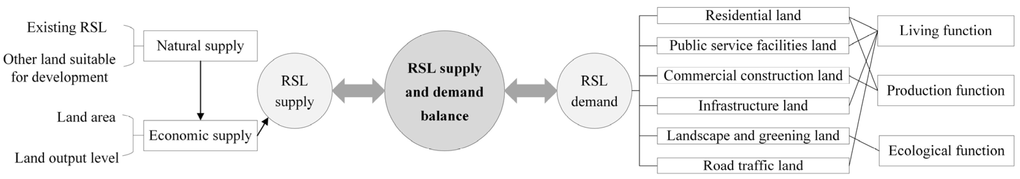
2.3.1. Theoretical Framework

Rural settlement land results from the interaction between land supply and land demand [31] (Figure 3). The supply of rural settlement land is usually divided into two categories: natural supply and economic supply. Natural supply refers to the amount of land that is naturally formed and available for farmers to use, including rural settlement land that has been used and land reserve resources that can be used in the future. Economic supply refers to the effective land supply that is developed through labor input on the basis of natural supply, which farmers can directly use for production and life. Its increase mainly comes from the growth of the rural settlement land area or the output level of rural settlement land per unit area. The demand for rural settlement land is the demand for rural residents to perform various consumption activities using rural settlement land for survival and development [42]. Various types of rural settlement land play different functions to meet the needs of rural residents in life, production, and ecology. The living function is mainly carried out by residential land, public service facilities land, infrastructure land, and road traffic land, which provide the space for rural residents’ daily work, rest, and communication. The production function includes two parts: the agricultural production function and non-agricultural production function. The agricultural production function is generally carried out by the yards of residential land or idle residential land, which provides space for farmers to plant, breed, and dry and store grain. The non-agricultural production function is mainly carried out by residential land and commercial construction land [43], which provide space for rural residents to engage in self-employed business, services, and handicrafts or industry. The ecological function is mainly carried out by landscape and greening land, which provides space for beautifying the rural living environment and controlling rural environmental pollution [44].
It can be seen from the supply and demand of rural settlement land that although the internal land structure of rural settlements is the most direct indicator to measure the functions of rural settlements [45], whether the functional demands of rural settlement can be met still depend on the land use pattern of the rural settlement, that is, the land output level in economic supply. Therefore, this study intends to evaluate rural settlement functions by analyzing characterization properties and focus on adjusting the internal land use structure of rural settlements to optimize functions.

2.3.2. Function Evaluation

(1) Indicator selection. Considering the accessibility and measurability of data, eight indicators were selected from three aspects, living function, production function, and ecological function, to establish an evaluation indicator system for rural settlement function. (1) Living function. The proportion of house reconstruction (LF1) refers to the proportion of newly constructed or reconstructed houses after 2000 to the total number of houses for which the construction time is available, reflecting farmers’ willingness to continue settling in their village. The perfectness of public service facilities (LF2) and infrastructure (LF3) refer to the proportion of the number of 10 types of public service facilities and 7 types of infrastructure, respectively, reflecting the living services and security level that rural settlements and their villages can provide for farmers. Road coverage (LF4) refers to the proportion of road area in rural settlements, reflecting the degree to which rural settlements meet the travel needs of residents within the village. (2) Production function. Per capita farmland area (PF1) refers to the amount of farmland each resident owns in a rural settlement. A large area of farmland usually requires more space in residential land for drying and storing grain, which also makes the food sources for livestock and poultry raised in residential land more abundant. The proportion of non-agricultural employment (PF2) refers to the proportion of non-agricultural industry employees who are not engaged in agriculture, forestry, animal husbandry, or fishery to the total number of rural employees in rural settlements, reflecting the ability of rural settlements to absorb non-agricultural employment. (3) Ecological function. Per capita landscape and greening land area (EF1) refers to the amount of landscape and greening land owned by each resident in rural settlements. Since the rural ecological environment construction in China is still in its infancy, the land area is directly selected to reflect the ecological service function provided by rural settlements to rural residents. The comprehensive index for air quality in 2021 (EF2) of each county where rural settlements are located was published by the Department of Ecology and Environment of Hebei Province [46], reflecting the impact of the regional ecological environment on the ecological functions in the settlement.
(2) Evaluation method. Firstly, the entropy method is adopted to calculate the weights of the function evaluation indicators of each rural settlement. This method determines the weight of each evaluation indicator according to the order degree of the information contained in it, which can eliminate the interference of human factors and make the evaluation results more scientific and reasonable [47]. The calculation steps can be found in reference [48]. Then, using indicator weights and standardized indicator attribute values, the function index of rural settlement is calculated by weighted summation. Based on the function measurement results of rural settlement, a coordination model is adopted to analyze the coordination degree among various sub-functions, such as production, life, and ecology, and the calculation formula can be found in reference [49]. Location entropy is adopted to measure the dominance degree of various functions of rural settlements to reveal the differences in dominant functions of different types of rural settlements, and the calculation formula can be found in reference [50]. An obstacle diagnosis model is adopted to explore the main factors hindering the improvement of rural settlement functions, and the calculation formula can be found in reference [51].

2.3.3. Land Use Optimization

(1) Optimization of quantity structure. If each state transition is only related to the state of the previous moment and is independent of the past state, or if the state transition process has no aftereffect, the state transition process can be called a Markov process [52]. The dynamic change in land use under certain conditions has the property of the Markov process, so this process is often used to predict land use changes [53]. The calculation formula is as follows:
P n = P n 1 P i j ,
where P(n) is the state probability vector after n-1 state transitions and reaching the nth transition; P(n − 1) is the state probability vector after n-2 state transitions and reaching the (n − 1)th transition; and Pij is the probability of state transition and should meet 0 ≤ Pij ≤ 1 and i = 1 n P i j = 1 [54].
(2) Optimization of spatial structure. The CLUE-S (the Conversion of Land Use and its Effects at Small regional extent) model was specifically developed for the spatially explicit simulation of land use change based on an empirical analysis of location suitability combined with the dynamic simulation of competition and interactions between the spatial and temporal dynamics of land use systems. The model includes two modules: a non-spatial demand module and a spatially explicit allocation procedure. The first module needs to calculate the area change for all land use types at the aggregate level, so this study will adopt the Markov model to predict the rural settlement land area. The second module can translate these non-spatial demands into land use changes at different locations within the study region, and its allocation is based upon a combination of empirical and spatial analysis and dynamic modeling. Four categories of information are needed to run this model, spatial policies and restrictions, land use type specific conversion settings, land use requirements (demand), and location characteristics, which together create a set of conditions and possibilities for which the model calculates the best solution in an iterative procedure. The CLUE-s allocation procedure can be found in reference [55].

3. Results

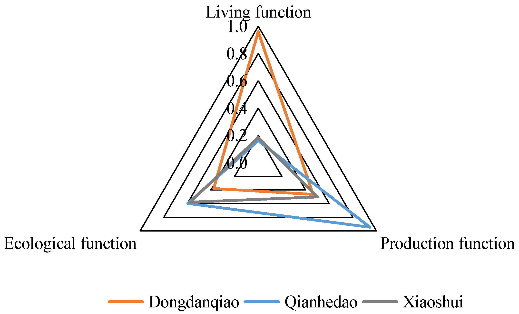
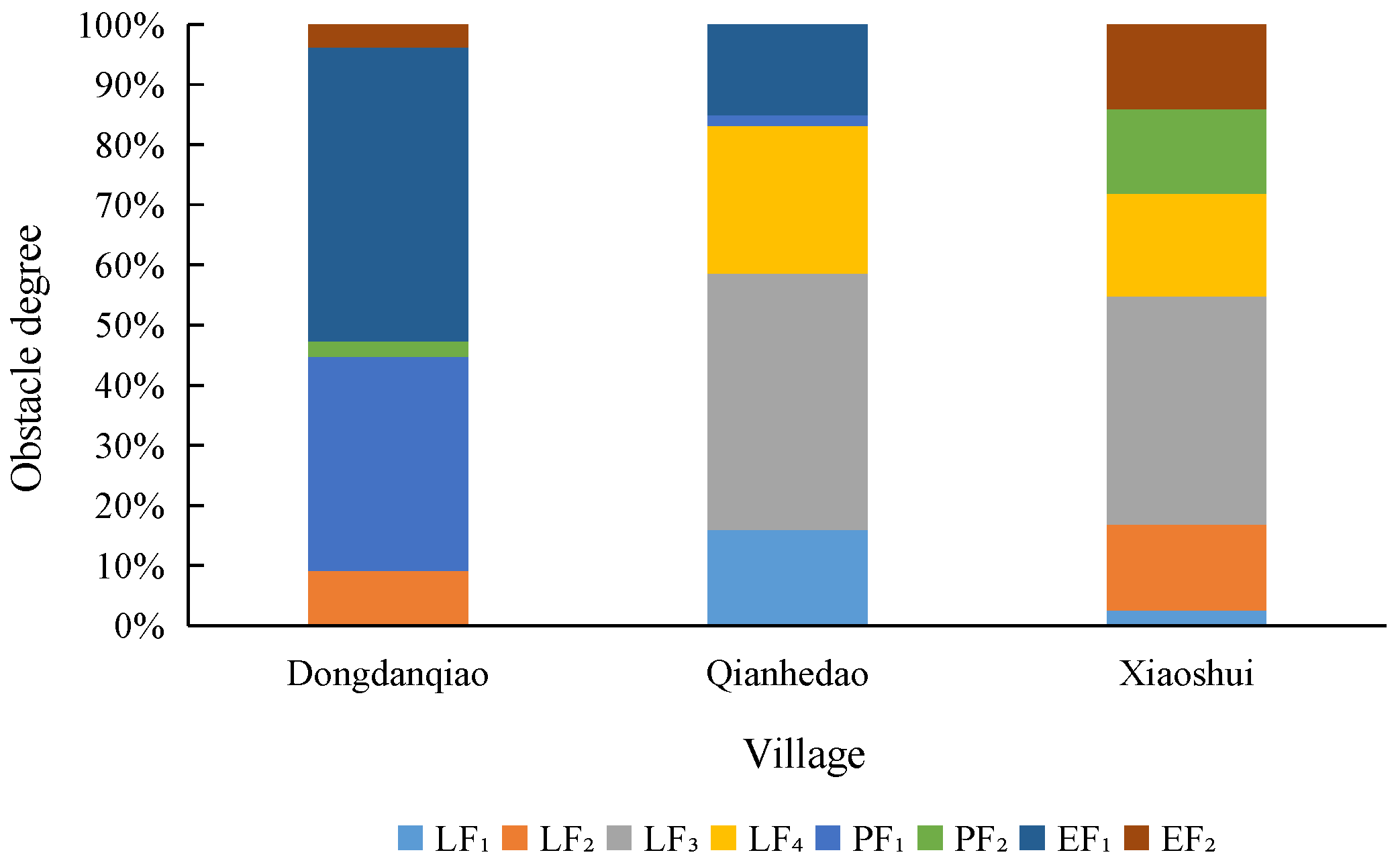
3.1. Multi-Function Evaluation of Rural Settlement

Through function measurement, it is known that the comprehensive function index of rural settlements in Dongdanqiao, Qianhedao, and Xiaoshui is 0.74, 0.41, and 0.33, respectively. The closer the relationship between rural settlements and towns, the more obvious the overall function of rural settlements.
Based on the measurement results of various sub-function indices of rural settlements (Figure 4) and their coordination analysis, it can be seen that Dongdanqiao has the highest multi-function coordination index, which is 0.47. The village has good housing conditions and various facilities, which play a more prominent living function, and its production and ecological functions are moderate and balanced. Qianhedao has the lowest multi-function coordination index, which is 0.13. The village has contiguous farmland, a ripe planting industry, and a good foundation for industrial development, which play a prominent production function. Its living function is minimal due to the low demand for new or reconstructed houses by farmers. Xiaoshui has a relatively high multi-function coordination index, which is 0.73. The production and ecological functions of the village are moderate and balanced, but its living function is low because of the lack of public service facilities.
The analysis results of the dominance degree are shown in Table 2. Regarding living function, Dongdanqiao has a significant advantage (dominance degree > 1.5); Qianhedao and Xiaosui do not reach the average level (dominance degree < 1). Regarding production function, only Qianhedao exceeds the average level (dominance degree > 1), and its agricultural and non-agricultural production functions are near the average level (dominance degree ≈ 1). Both Dongdanqiao and Xiaoshui reach the average level; the former has certain advantages in non-agricultural production function but lacks agricultural production function, and the latter has significant advantages in agricultural production function, but its non-agricultural production function does not reach the average level. Regarding ecological function, only Xiaoshui exceeds the average level, while Dongdanqiao and Qianhedao do not reach the average level, and the former’s disadvantage is more obvious.
The results of obstacle factor diagnosis are shown in Figure 5. The main obstacles to the settlement functioning of Dongdanqiao are per capita farmland area (PF1) and per capita landscape and greening land area (EF1). The village should try to improve the agricultural production scale and strengthen the construction of ecological land in the future. The main obstacles to the settlement functioning of Qianhedao and Xiaoshui are the perfectness of infrastructure (LF3) and road coverage (LF4). The two villages should strengthen the construction of life service facilities in the future. In addition, the obstacles to the settlement functioning of Qianhedao also include the proportion of house reconstruction (LF1) and the per capita landscape and greening land area (EF1). In the long run, the village should improve the living environment and increase the greening land. The obstacles to the settlement functioning of Xiaoshui also include the perfectness of public service facilities (LF2), the proportion of non-agricultural employment (PF2), and the air quality index (EF2). In the long run, the village should construct infrastructure, develop non-agricultural industries, and improve the service functions of ecological land in the village.

3.2. Internal Land Use Optimization of Rural Settlement

3.2.1. Quantity Structure Prediction

This study divides rural settlement land into seven types: residential land (L1), public service facilities land (L2), commercial construction land (L3), infrastructure land (L4), landscape and greening land (L5), road traffic land (L6), and vacant land (L7). Focusing on the primary land types that obstruct the functioning of rural settlements and their influence degree, the transition probability matrix of rural settlement land types for each village from 2010 to 2020 is adjusted to obtain the transition probability matrix of rural settlement land types for each village from 2020 to 2030.
Taking Dongdanqiao as an example, the village needs to focus on improving its ecological and agricultural production functions in the future. The village should develop factory agriculture with a high level of intensive land use and supply fresh agricultural products to urban areas to compensate for the shortage of per capita farmland. The development of factory agriculture requires a certain area of processing and service facilities as supporting facilities, so this study will raise the probability of transferring vacant land to commercial construction land and landscape and greening land to 35% and 50%, respectively. In order to improve land use efficiency, new residential land in many areas is not approved at present, so this study will reduce the probability of transferring vacant land to residential land and road traffic land to 0 (Table 3).
Qianhedao needs to focus on improving its living functions and providing material guarantees for a large number of the agricultural population who rely on large farmland to develop large-scale agriculture in the future, so the infrastructure land, road traffic land, and landscape and greening land of the village will be supplemented in the adjustment. In addition to improving the living function, Xiaoshui also needs to provide various types of land for the improvement of the non-agricultural production function of the settlement, the development of family farms or leisure agriculture, and the extension of the agricultural industry chain in the long term, so the commercial construction land of the village will be supplemented in the adjustment. Due to space limitations, this paper will not show the transition probability matrices of rural settlement land types for the above two villages. According to the adjusted transition probability matrices of rural settlement land type, the rural settlement land structures of the three villages in 2030 can be predicted (Table 4).

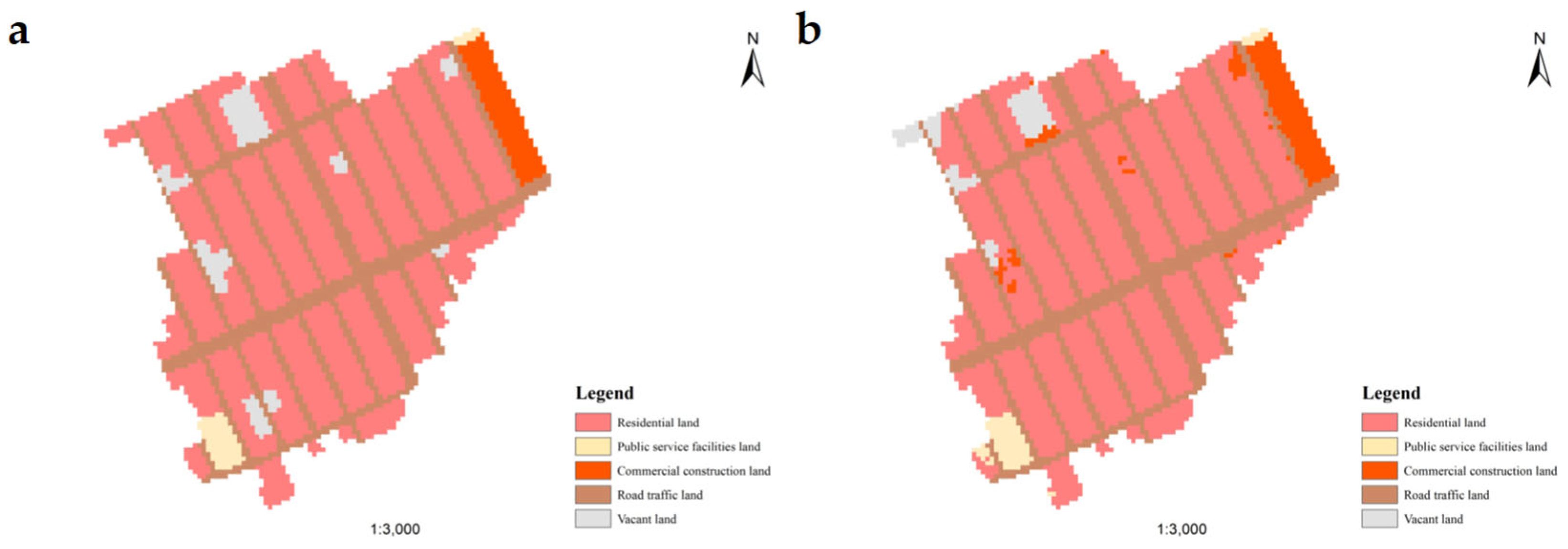
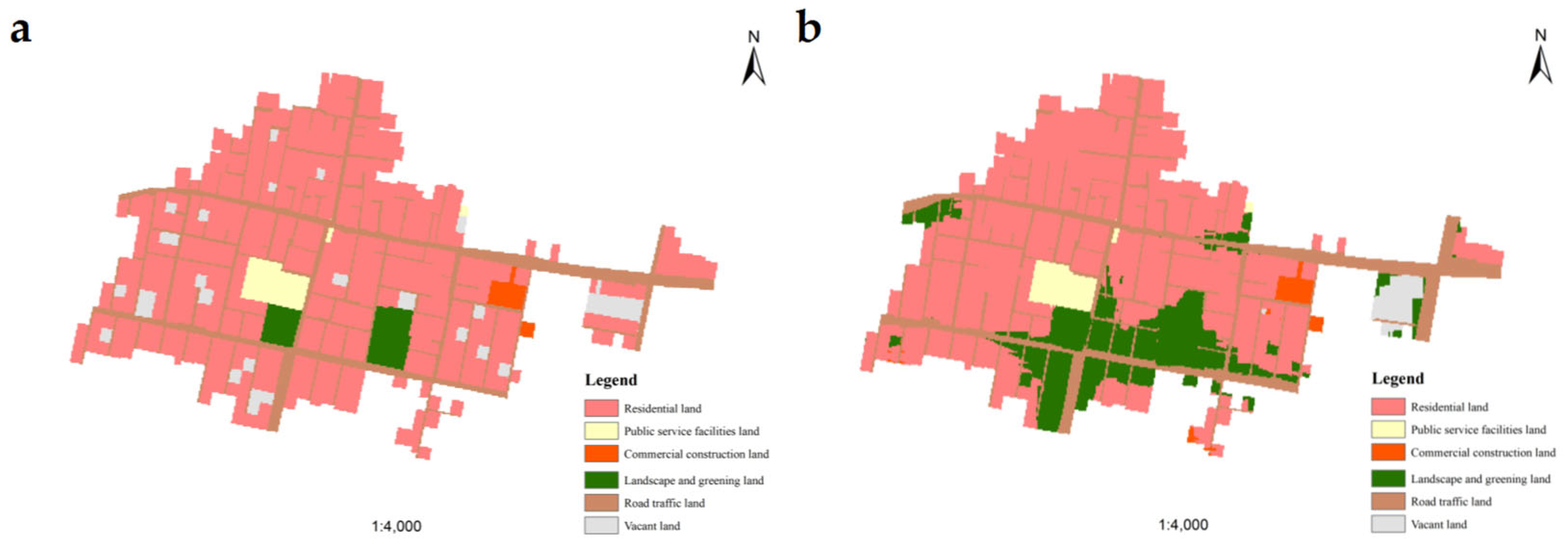
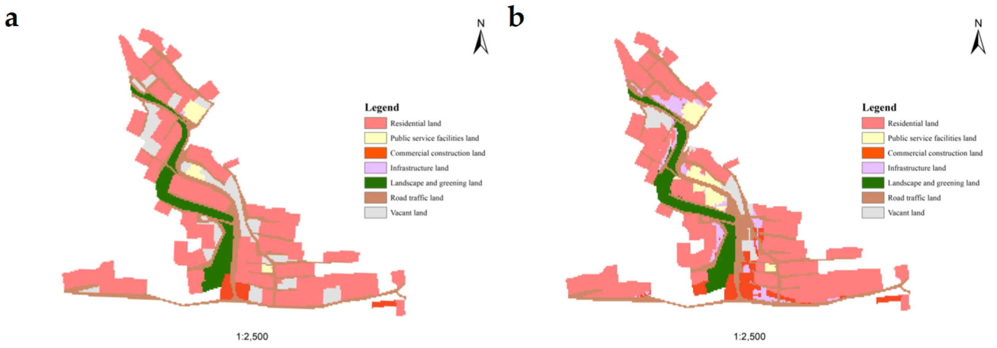
3.2.2. Spatial Structure Simulation

(1)
Model operation process
This study takes Dongdanqiao as an example to introduce the main process of using the CLUE-S model to simulate rural settlement land’s spatial structure. (1) Preparation of rural settlement maps for the initial year. This study takes 2010 as the initial year for simulation and sets the accuracy of raster data to 5 m. (2) Prediction of demand for rural settlement land. Based on the area of rural settlement land in 2010 and 2020, the linear interpolation method is used to calculate the rural settlement land structure each year from 2010 to 2020. (3) Setting of restricted area. This study assumes that all the land within the rural settlement range can be converted, so all grid values are set to 0. (4) Determination of the transition matrix of rural settlement land types. This study assumes that all rural settlement land types can be transformed into each other. Since there are five land use types in the settlement, a 5 × 5 land use transfer matrix is defined, where the values are all 1. (5) Selection of driving factors for rural settlement land. Considering the accessibility, quantification, feasibility, regional differences, time consistency, and comprehensiveness of factor data, seven driving factors are selected in this study. Among them, elevation, slope, and aspect reflect the influence of physical geography, and distance from main roads, farmlands, waters, and village committee reflect the influence of society and economy. (6) Sifting of driving factors for rural settlement land. IBM SPSS Statistics 21 is adopted to perform logistic regression analysis between various kinds of rural settlement land and driving factors, and the results are shown in Table 5. ROC is used to measure the goodness of fit of the logistic regression model, and the ROC values of most driving factors are greater than 0.8, indicating that the selected driving factors have good interpretation effects. Since the distribution of residential land and road traffic land is wide and uniform, their ROC values are less than 0.7 but greater than 0.5, indicating that the selected driving factors have certain interpretation effects. In addition, the driving factors affecting different land use types are different. (7) Setting of the main parameters of the model. For example, the transfer elasticity coefficients of various rural settlement lands are set to 0.2, 1, 0.4, 0.8, and 0, respectively. (8) Model operation and effectiveness verification. The simulation result of rural settlement land in Dongdanqiao in 2020 is compared with the real situation, and the effectiveness of the simulation results is verified by calculating the Kappa coefficient. The calculation formula can be found in reference [56]. The Kappa coefficient is 0.8894, indicating that the simulation results are consistent with the real distribution, and this model can be adopted to continue to predict the spatial structure of rural settlement land in 2030 in this village.
Next, taking 2020 as the initial year and the area of each rural settlement land type of Dongdanqiao in 2030 in Table 3 as the land use demand in the final year, through re-sifting the driving factors, the spatial structure of the village’s rural settlement land in 2030 will be simulated with the CLUE-S model. Similarly, the spatial structure of rural settlement land for the other two villages can also be simulated.
(2)
Simulation results
The simulation results of the spatial structure of rural settlement land in Dongdanqiao in 2030 are shown in Figure 6b. Compared with the land use conditions in 2020 (Figure 6a), there are several changes in the future land layout of the settlement: (1) Part of the vacant land in the north of the settlement, which has a high slope and is inconvenient for farmers’ lives, will be transformed into commercial construction land for developing agricultural processing or the service industry and improving agricultural production capacity. (2) Part of the vacant land will be transformed into residential land for the approval of new homesteads, and part of the scattered residential land will be vacated as vacant land or transformed into public service facilities land to improve the intensive use of rural construction land. (3) To ensure the normal operation of the model, the simulation process did not involve landscape and greening land, which was nonexistent at that time, and infrastructure land, which was only 10 m2. However, they can be developed from vacant land or road and traffic land in the future to improve the ecological and living functions of the settlement.
Due to the relatively scattered distribution of rural settlement land in the exurban and remote villages, grid data with an accuracy of 1 m were used to simulate the spatial pattern of rural settlement land in Qianhedao and Xiaoshui. According to the calculation, the Kappa coefficient of the spatial structure simulation of rural settlement land in Qianhedao in 2020 is 0.8328, which means the simulation result is good. The simulation results of the spatial structure of rural settlement land in 2030 are shown in Figure 7b. Compared with the land use conditions in 2020 (Figure 7a), there are several changes in the future land layout of the settlement: (1) A large number of scattered vacant land in the settlement will be transformed into residential land, and part of the scattered residential land will be vacated as vacant land to promote the contiguous use of residential land, facilitate the unified layout of living service facilities, and improve farmers’ living standards. (2) A large amount of landscape and greening land will be developed in the low-lying areas, such as surrounding ponds, to improve the ecological function of the settlement. (3) To ensure the normal operation of the model, the simulation process did not involve infrastructure land, which was nonexistent at that time. However, it can be developed from vacant land in the east of the settlement in the future to improve the living function of the settlement.
The Kappa coefficient of the spatial structure simulation of rural settlement land in Xiaoshui in 2020 is 0.8160, which means the simulation result is good. The simulation results of the spatial structure of rural settlement land in 2030 are shown in Figure 8b. Compared with the land use conditions in 2020 (Figure 8a), there are several changes in the future land layout of the settlement: (1) Part of the vacant land located on the sunny slope in the southeast of the settlement will be transformed into residential land to improve the living standard of farmers. (2) Part of the land with a high slope around the village committee will be used to construct public service facilities, and part of the land with a low slope will be used to construct infrastructure to improve the living function of the settlement. (3) Commercial construction land will be developed in the low-elevation area in the south of the settlement to carry out non-agricultural production activities and improve the production function of the settlement.

4. Discussion

4.1. Promoting Urban–Rural Integration in the Suburban Village

Suburban villages, represented by Dongdanqiao, should fully exploit the geographical superiority of neighboring towns. They could be rehabilitated and improved, driven by serving the town’s development.
The production and ecological function of Dongdanqiao were relatively low because of the lack of farmland and landscape and greening land. Moreover, due to the village being close to the town, its land use was more intensive, and there was little vacant land available for development. Therefore, it is important to focus on how to improve the utilization efficiency of existing land in such villages. Firstly, modern agriculture such as factory agriculture, contract agriculture, and leisure agriculture should be further developed on farmland, which not only improves the value added of agriculture but also strongly meets urban consumption demand. Based on considering the existing cottage industry, the village should develop agricultural processing at the right moment by increasing or activating commercial construction land to promote the integrated development of rural primary, secondary, and tertiary industries. Secondly, the village should focus on landscape and greening construction in streets and alleys, and fully utilize the developed land to improve the ecological function of the settlements. But different from urban greening, rural greening should focus on reflecting local culture. For example, the stumps of fruit trees can be used as greening isolation belts and retaining walls along the main road; flowers, plants, or vegetables can be planted in secondary streets, corners, or residential courtyards according to villagers’ needs; and if there is insufficient greening space in secondary streets and alleys, liana or potted plants can also carry out vertical greening [57]. Finally, the village should build a sharing center for rural life by fully making use of the advantage of the living function to provide services for local villagers, tourists, or employees of surrounding enterprises. In this process, it is encouraged to further activate the existing construction land and build living facilities on inefficient vacant land or residential land to improve land use efficiency.

4.2. Promoting Aggregation and Improvement in the Exurban Village

Exurban villages, represented by Qianhedao with large-scale agriculture production, should focus on how to build beautiful and livable villages through rehabilitation and improvement to meet the residential and living needs of a large agricultural population.
The author found through field investigation that since Qianhedao was more remote compared to the suburban village of Dongdanqiao, it had a weaker land use intensity. In addition, the economic development of Qianhedao was better than that of the remote village of Xiaoshui, so its residents had a stronger ability to build new houses. As a result, the phenomenon of villagers building new houses around settlements with more convenient living conditions such as transportation and environment was the most common in Qianhedao. There was more idle and abandoned residential land within the settlement, with old houses, outdated infrastructures, and insufficient landscape and greening, ultimately leading to the lower living functions of the settlement. Therefore, it is recommended that based on the reform of rural residential land systems, the village should explore the transfer and exit mechanisms of the right to the use of rural residential land, and promote the policy implementation of one homestead for one family, to effectively promote the contiguous use of rural residential land. The above is not only beneficial for improving land use efficiency but also convenient for the centralized layout of living facilities within the settlement, effectively eliminating the differences between the internal conditions and the external environment of the settlement [58]. Moreover, the residential lands that were vacated voluntarily can be used for the construction of landscape and greening land such as street crossing center gardens and farmers’ vegetable gardens to improve the ecological function of the settlement, or to increase the flexible space to ensure the future development needs of new industries in the village.

4.3. Promoting Characteristic Protection in the Remote Village

Remote villages, represented by Xiaoshui with laggard living conditions but superior natural landscapes and agricultural production, should improve their living facilities as soon as possible, and develop characteristic industries and rural tourism by reasonably protecting and utilizing characteristic resources.
The unique natural conditions of such villages such as terrain and landform should be fully considered in the construction of living facilities to improve the living function of the settlement scientifically. As for roads, it is recommended that some roads should be appropriately widened, straightened, or hardened based on continuing the original road network of the settlement, pedestrian steps should be set between the platforms, and energy-saving lamps with solar energy should be installed along the main roads. Due to such settlements having superior natural environments, they should carry out ecological and landscape construction on the premise of maintaining the existing ecological spatial pattern and the original landscape. In terms of industrial development, based on existing characteristic agricultural products in such villages, agricultural and sideline product processing industries should be introduced by increasing commercial construction land. Furthermore, sightseeing agriculture should be introduced by leveraging the beautiful natural environment of the village. Finally, an industry chain for characteristic agriculture should be formed to effectively improve farmers’ income and promote the economic development of the village.

5. Conclusions

This study analyzed the level of production, living, and ecological functions and their coordination degree, dominance degree, and obstacle factors for different types of villages by establishing an evaluation indicator system and combining it with field investigation results. Then, based on the land use status and function requirements of different types of rural settlements, the Markov model was adopted to predict the quantity structure of rural settlement land, and the CLUE-S model was adopted to simulate the spatial structure of rural settlement land.
The function evaluation results showed that the closer the relationship between rural settlements and towns, the more obvious the overall function of rural settlements, but the performances of sub-functions of different types of settlements were different. The multi-function coordination degree of suburban settlements was high, with a prominent living function and relatively low production and ecological functions, mainly restricted by per capita farmland area and per capita landscape and greening land area. The multi-function coordination degree of exurban settlements was low, with a prominent production and a moderate ecological function. Their living function was low, which was affected by the perfectness of infrastructure and road coverage. In addition, the proportion of house reconstruction and per capita landscape and greening land area also showed a restricting effect. The multi-function coordination degree of remote settlements was relatively high, with a prominent ecological function and a moderate production function. The main obstacles affecting the living function were the same as those of the exurban settlement. In addition, the perfectness of public service facilities, the proportion of non-agricultural employment, and the air quality index also showed a restricting effect.
After the optimization of quantity and spatial structure, in the suburban settlement, the vacant land with a high slope was transformed into commercial construction land, while the rest was transformed into residential land; in order to achieve a balance in the total amount of residential land, some scattered residential land was vacated as vacant land or transformed into public service facilities land. In the exurban settlement, some scattered residential land and vacant land were replaced in space to promote the contiguous use of residential land; a large amount of new landscape and greening land continued to be added in low-lying areas. In the remote settlement, part of the vacant land located on the sunny slope was transformed into residential land, public service facilities land was added around the original village committee, infrastructure land was added in the area with a low slope, and commercial construction land was added in the area with low elevation.
This article provides reference and guidance for optimizing the internal land use of three typical villages and other villages with similar characteristics by scientifically setting land scale targets and selecting driving factors for land layout. It can also provide a theoretical basis and technical support for implementing rural land consolidation and village planning in relevant areas, which is conducive to promoting urban–rural integration development and rural comprehensive revitalization. But in the course of concrete practice, some social and humanistic factors such as government intervention, property rights adjustment, and farmers’ willingness need to be considered in optimizing land use structure at the micro scale, such as in rural areas.

Author Contributions

Conceptualization, N.W. and L.Z.; methodology, N.W.; software, N.W.; formal analysis, N.W.; investigation, N.W., L.Z. and J.Z.; data curation, N.W.; writing—original draft preparation, N.W.; writing—review and editing, N.W. and L.Z.; visualization, N.W.; supervision, L.Z. and J.H.; funding acquisition, N.W. and J.H. All authors have read and agreed to the published version of the manuscript.

Funding

This research was funded by the National Natural Science Foundation of China, grant number 42301318, and the National Key Technology Research and Development Program of the Ministry of Science and Technology of China, grant number 2015BAD06B01.

Data Availability Statement

Publicly available sources of the data used in this study are described in the article; for other data used, please contact the corresponding author on reasonable grounds.

Acknowledgments

The authors appreciate the insightful and constructive comments of the anonymous reviewers.

Conflicts of Interest

The authors declare no conflicts of interest.

References

  1. Zhou, G.; He, G.; Tang, Y.; Qu, Q.; Peng, P. On rural settlement patterns in new era. Prog. Geogr. 2010, 29, 186–192. [Google Scholar]
  2. Tu, S.; Zhou, X.; Long, H.; Liang, X. Research progress and prospect of spatial evolution and optimization of rural settlements. Econ. Geogr. 2019, 39, 142–149. [Google Scholar]
  3. Ma, X.; Li, Q.; Shen, Y. Morphological difference and regional types of rural settlements in Jiangsu Province. Acta Geogr. Sin. 2012, 67, 516–525. [Google Scholar]
  4. Song, W.; Li, H. Spatial pattern evolution of rural settlements from 1961 to 2030 in Tongzhou District, China. Land Use Policy 2020, 93, 441–448. [Google Scholar] [CrossRef]
  5. Chen, Z.; Liu, T.; Feng, W.; Li, Y.; Li, L. Study on spatial tropism distribution of rural settlements in the Loess Hilly and Gully Region based on natural factors and traffic accessibility. J. Rural Stud. 2022, 99, 105044. [Google Scholar] [CrossRef]
  6. Prus, B.; Wilkosz-Mamcarczyk, M.; Salata, T. Landmarks as cultural heritage assets affecting the distribution of settlements in rural areas-an analysis based on LIDAR DTM, digital photographs, and historical maps. Remote Sens. 2020, 12, 1778. [Google Scholar] [CrossRef]
  7. Qu, Y.; Jiang, G.; Ma, W.; Li, Z. How does the rural settlement transition contribute to shaping sustainable rural development? Evidence from Shandong, China. J. Rural Stud. 2021, 82, 279–293. [Google Scholar]
  8. Rosner, A.; Wesołowska, M. Deagrarianisation of the economic structure and the evolution of rural settlement patterns in Poland. Land 2020, 9, 523. [Google Scholar] [CrossRef]
  9. Gorbenkova, E.; Shcherbina, E. Historical-genetic features in rural settlement system: A case study from Mogilev District (Mogilev Oblast, Belarus). Land 2020, 9, 165. [Google Scholar] [CrossRef]
  10. Zhao, F.; Zhang, S.; Du, Q.; Ding, J.; Luan, J.; Xie, Z. Assessment of the sustainable development of rural minority settlements based on multidimensional data and geographical detector method: A case study in Dehong, China. Socio-Econ. Plan. Sci. 2021, 78, 101066. [Google Scholar] [CrossRef]
  11. Munyai, R.B.; Chikoore, H.; Musyoki, A.; Chakwizira, J.; Muofhe, T.P.; Xulu, N.G.; Manyanya, T.C. Vulnerability and adaptation to flood hazards in rural settlements of Limpopo Province, South Africa. Water 2021, 13, 3490. [Google Scholar] [CrossRef]
  12. Dakey, S.; Morey, B.; Sukhwani, V.; Deshkar, S. Applying socio-ecological perspective for fostering resilience in rural settlements-Melghat Region, India. Sustainability 2023, 15, 1812. [Google Scholar] [CrossRef]
  13. Kong, X.; Liu, D.; Tian, Y.; Liu, Y. Multi-objective spatial reconstruction of rural settlements considering intervillage social connections. J. Rural Stud. 2021, 84, 254–264. [Google Scholar]
  14. Lu, M.; Wei, L.; Ge, D.; Sun, D.; Zhang, Z.; Lu, Y. Spatial optimization of rural settlements based on the perspective of appropriateness–domination: A case of Xinyi City. Habitat Int. 2020, 98, 101248. [Google Scholar]
  15. Barbosa, V.; Santé-Riveira, I.; Crecente-Maseda, R.; Redondo, C.D.; Trinidad, J.P.; López, J.P.; Biempica, R.D.; Neto, J.A.F. A New Spatial Criteria Method to Delimit Rural Settlements towards Boundaries Equity: Land Use Optimization for Decision Making in Galicia, NW Spain. Land 2022, 11, 800. [Google Scholar] [CrossRef]
  16. Kilic, D.; Yagci, C.; Iscan, F. A GIS-based multi-criteria decision analysis approach using AHP for rural settlement site selection and eco-village design in Erzincan, Turkey. Socio-Econ. Plan. Sci. 2023, 86, 101478. [Google Scholar] [CrossRef]
  17. Bański, J.; Wesołowska, M. Transformations in housing construction in rural areas of Poland’s Lublin region-Influence on the spatial settlement structure and landscape aesthetics. Landscape Urban Plann. 2010, 94, 116–126. [Google Scholar]
  18. Sikorski, D.; Latocha, A.; Szmytkie, R.; Kajdanek, K.; Miodońska, P.; Tomczak, P. Functional changes in peripheral mountainous areas in east central Europe between 2004 and 2016 as an aspect of rural revival? Kłodzko County case study. Appl. Geogr. 2020, 122, 102223. [Google Scholar]
  19. Xu, Q.; Li, Y.; Huang, J. Study on land pattern and function evolution of rural settlements dependent on scenic spot: A case study of Shitouzhai Village in Huangguoshu Town. Resour. Environ. Yangtze Basin 2020, 29, 1545–1554. [Google Scholar]
  20. Jiang, G.; Zhang, F.; Tang, X.; Huo, H.; Zhao, T. Analysis of ecosystem servive function of land use in rural residential land of Pinggu district, Beijing. Trans. Chin. Soc. Agric. Eng. 2009, 25, 210–216. [Google Scholar]
  21. Chen, C. Study on the rural settlements multi-functionality evaluation at village scale in Qidong City. Resour. Environ. Yangtze Basin 2014, 23, 1425–1431. [Google Scholar]
  22. Zhang, L. The Land Use Functional Evolution and Its Spatial Differentiation of Rural Settlements. Master’s Thesis, Southwest University, Chongqing, China, 2017. [Google Scholar]
  23. Qu, Y.; Wu, M.; Zhan, L.; Shang, R. Multifunctional evolution and allocation optimization of rural residential land in China. Land 2023, 12, 339. [Google Scholar] [CrossRef]
  24. Ma, W.; Jiang, G.; Li, W.; Zhou, T.; Zhang, R. Multifunctionality assessment of the land use system in rural residential areas: Confronting land use supply with rural sustainability demand. J. Environ. Manag. 2019, 231, 73–85. [Google Scholar]
  25. Wang, Y.; Li, G. Functional transformation and spatial reconstructing of rural settlements in southern Jiangsu: A case study of Suzhou. City Plann. Rev. 2011, 35, 54–60. [Google Scholar]
  26. Long, H.; Tu, S. Land use transition and rural vitalization. China Land Sci. 2018, 32, 1–6. [Google Scholar]
  27. Ma, W.; Jiang, G.; Wang, D.; Li, W.; Guo, H.; Zheng, Q. Rural settlements transition (RST) in a suburban area of metropolis: Internal structure perspectives. Sci. Total Environ. 2018, 615, 672–680. [Google Scholar]
  28. Yang, X.; Yang, Z.; Zhu, Y. Rural settlements functional transformation and spatial restructuring in world heritage sites: Take Tangkou, Zhaixi and Shancha as examples. Geogr. Res. 2020, 39, 2214–2232. [Google Scholar]
  29. Zhang, Z.; Hua, Y. Evaluation and optimization for rationality of rural settlement distribution based on function perspective. China Dev. 2019, 19, 38–43. [Google Scholar]
  30. Jia, K.; Qiao, W.; Chai, Y.; Feng, T.; Wang, Y.; Ge, D. Spatial distribution characteristics of rural settlements under diversified rural production functions: A case of Taizhou, China. Habitat Int. 2020, 102, 102201. [Google Scholar]
  31. Yang, C.; Xu, X.; Zhang, H.; Hu, Y. Evolution and optimization features of rural residential areas based on ‘the functions of production-living-ecological spaces’ in Shanghai. Resour. Environ. Yangtze Basin 2021, 30, 2392–2404. [Google Scholar]
  32. Yang, D.; Sun, J.; Zhang, Y.; Luo, J.; Zhao, Y.; Zhang, J. Classification of consolidation type of rural settlements in Karst Mountainous Areas based on “production-living-ecological” functions: Taking Qixingguan District as an example. China Land Sci. 2021, 35, 80–89. [Google Scholar]
  33. Zhang, B.; Zhang, F.; Zhou, J.; Qu, Y. Functional evolution of rural settlement based on micro-perspective: A case study of Hetaoyuan Village in Yishui County, Shandong Province. Sci. Geogr. Sin. 2015, 35, 1272–1279. [Google Scholar]
  34. Department of Rural Social and Economic Investigation, National Bureau of Statistics of the PRC. China Rural Statistical Yearbook; China Statistics Press: Beijing, China, 2023; p. 35.
  35. Chen, M.; Wu, C. Urbanization and village land readjustment. Econ. Geogr. 1999, 19, 97–100. [Google Scholar]
  36. Jiang, G.; Zhang, F.; Zhou, Y.; Zhao, T.; Xie, Z. Analyzing the land use structure characteristics of rural residential area in Beijing City. Resour. Sci. 2007, 29, 109–116. [Google Scholar]
  37. Ma, W.; Jiang, G.; Zhang, R.; Li, Y.; Jiang, X. Achieving rural spatial restructuring in China: A suitable framework to understand how structural transitions in rural residential land differ across peri-urban interface? Land Use Policy 2018, 75, 583–593. [Google Scholar]
  38. Zhang, T.; Zhou, J.; Zhang, F.; Xie, Z.; Zhang, B. Research on land use evolution in rural residential areas under the background of industrialization and urbanization. J. China Agric. Univ. 2018, 23, 147–157. [Google Scholar]
  39. Tian, Y.; Jiang, G.; He, X.; Qu, Y.; Zhou, D. Internal land use structure difference analysis of rural settlements in Pinggu District, Beijing. Trans. Chin. Soc. Agric. Eng. 2019, 35, 263–273. [Google Scholar]
  40. Zhang, X.; Wang, H.; Liu, J. Research on the evolution of land use structure of rural settlements in underdeveloped agricultural areas. Chin. J. Agric. Resour. Reg. Plann. 2020, 41, 195–202. [Google Scholar]
  41. Tang, X.; Liu, Y.; Ren, Y.; Yang, Y. Research on the internal land use landscape of rural settlements in ecological conservation area. Trans. Chin. Soc. Agric. Mach. 2022, 63, 189–196. [Google Scholar]
  42. Qu, F. Land Economics, 3rd ed.; China Agriculture Press: Beijing, China, 2011; pp. 32–41. [Google Scholar]
  43. Zhang, B.; Zhang, F.; Gao, Y.; Li, C.; Zhu, F. Identification and spatial differentiation of rural settlements’ multifunction. Trans. Chin. Soc. Agric. Eng. 2014, 35, 216–224. [Google Scholar]
  44. Qu, Y.; Liu, M.; Zhu, W.; Zhan, L.; Ping, Z. Spatial pattern and coordination optimization mode of multifunction of rural settlements. J. Nat. Resour. 2021, 36, 659–673. [Google Scholar]
  45. Zhu, F.; Zhang, F.; Li, C.; Zhu, T. Functional transition of the rural settlement: Analysis of land-use differentiation in a transect of Beijing, China. Habitat Int. 2014, 41, 262–271. [Google Scholar]
  46. Ranking of Ambient Air Quality in Hebei Province in 2021. Available online: http://hbepb.hebei.gov.cn/res/hbhjt/upload/file/20220124/42d845d948024bf6aa5b3e6e3a10b71a.pdf (accessed on 24 February 2025).
  47. Zhao, L.; Zhu, Y.; Fu, M.; Zhang, P.; Cao, Y. Comparative study on intensive use of rural residential land based on principal component analysis and entropy. Trans. Chin. Soc. Agric. Eng. 2012, 28, 235–242. [Google Scholar]
  48. Zhang, Y. Evaluation on the sustainable development of resources city in arid region based on entropy. Resour. Ind. 2016, 8, 1–6. [Google Scholar]
  49. Zhao, H.; Chen, C.; Hu, Z.; Li, L. Evaluation of intensive urban land use and analysis of obstacle factors in northern slope of Tianshan mountains. Trans. Chin. Soc. Agric. Eng. 2018, 34, 258–266. [Google Scholar]
  50. Yang, H.; Yang, C.; Xin, G.; Li, Y.; Cao, R. Multifunction evaluation of rural settlements in the southwest hilly area and its optimizing strategies—A case study in Rongchang district of Chongqing. Chin. J. Agric. Resour. Reg. Plann. 2020, 41, 153–161. [Google Scholar]
  51. Qu, Y.; Wang, S.; Zhao, L.; Qu, Y.; Wang, S. Spatial pattern and regional regulation of rural territorial multi-functions in Shandong Province, China. Trans. Chin. Soc. Agric. Eng. 2020, 36, 222–232. [Google Scholar]
  52. Xu, J. Mathematical Methods; Higher Education Press: Beijing, China, 1996. [Google Scholar]
  53. Wang, L.; Bao, H.; Qin, B. The dynamic monitoring and prediction of the regional land use change based on RS and GIS. Econ. Geogr. 2000, 20, 47–51. [Google Scholar]
  54. Gao, Z.; Zhao, X. Prediction of land use variation change based on GIS. J. Cap. Norm. Univ. (Nat. Sci. Ed.) 2002, 23, 75–79+80. [Google Scholar]
  55. Dyna-CLUE Manual and CLUE Tutorial with Exercises. Available online: https://dataverse.nl/dataset.xhtml?persistentId=doi:10.34894/FD1COL (accessed on 10 February 2025).
  56. Sun, J. Study on Trading Off the Conflicts and Optimizing the Pattern of Multifunctional Rural Landscape Based on Ecological Civilization. Ph.D. Thesis, China Agricultural University, Beijing, China, 2019. [Google Scholar]
  57. Liu, Y. Research on the Development Strategy of Suburban Fusion Village Space Under the Background of Rural Revitalization Strategy-Taking Qiuxian Village in Beijing as an Example. Master’s Thesis, Beijing University of Civil Engineering and Architecture, Beijing, China, 2020. [Google Scholar]
  58. Wang, N.; Gu, T.; Hao, J.; Zu, J. Influencing factors of multiple homesteads for one family in rural Huang-Huai-Hai Plain based on household characteristics: A case study of Qianhedao Village in Quzhou County, Hebei Province. Areal Res. Dev. 2022, 41, 1–6. [Google Scholar]
Figure 1. Research framework.
Land 14 00704 g001
Figure 2. Location of typical villages. Note: the map of China is downloaded from the standard map system of the Ministry of Natural Resources of China.
Land 14 00704 g002
Figure 3. Supply and demand of rural settlement land (RSL).
Land 14 00704 g003
Figure 4. Measurement results of various sub-function indices of rural settlements.
Land 14 00704 g004
Figure 5. Results of obstacle factor diagnosis for functions of rural settlements.
Land 14 00704 g005
Figure 6. Status of 2020 (a) and simulation results of 2030 (b) for the spatial structure of rural settlement land in Dongdanqiao.
Land 14 00704 g006
Figure 7. Status of 2020 (a) and simulation results of 2030 (b) for the spatial structure of rural settlement land in Qianhedao.
Land 14 00704 g007
Figure 8. Status of 2020 (a) and simulation results of 2030 (b) for the spatial structure of rural settlement land in Xiaoshui.
Land 14 00704 g008
Table 1. The important topics of rural settlement research in recent years.
Research Interests in Rural SettlementMain Research Contents
EvolutionThe law of spatial–temporal changes of rural settlements within a region and its influencing factors were analyzed.
TransformationThe rural developments were analyzed from the perspectives of population, land, and their interactive relationships. They particularly pointed out the polarized development of rural settlements.
Sustainable developmentBased on a series of indicators, the sustainability of rural settlements in specific regions and their influencing factors were analyzed.
ResilienceThe vulnerabilities of rural settlements to external disasters, especially climate disasters, were evaluated, and suggestions to improve their resilience were put forward.
Spatial reconstructionConsidering rural social relations, farming radius, and boundary fairness, respectively or comprehensively, including a series of factors, a framework or model for rural settlement spatial reconstruction was established, and the spatial pattern of rural settlements was optimized.
The table was organized from references [4,5,6,7,8,9,10,11,12,13,14,15,16].
Table 2. Dominance degrees of various functions of rural settlements.
Functions of Rural SettlementDongdanqiaoQianhedaoXiaoshui
Life2.450.810.81
ProductionAgricultural production0.30.611.200.980.931.57
Non-agricultural production1.071.000.90
Ecology0.490.911.29
Table 3. Transition probability matrix of rural settlement land types.
Rural Settlement Land TypesL1L2L3L4L5L6L7
L11.000
L2 1.000
L3 0.0580.942
L4 1.000
L5 1.000
L6 0.001 0.999
L70.498/0 * 0/0.350 0/0.5000.070/00.433/0.150
* Figures before and after “/” are the transition probabilities before and after adjustment, respectively.
Table 4. Rural settlement land structures of typical villages in 2030. Unit: hm2.
VillageL1L2L3L4L5L6L7
Dongdanqiao9.760.280.760.010.334.080.10
Qianehdao14.380.590.310.443.724.700.02
Xiaoshui3.160.240.300.270.591.340.23
Table 5. Regression coefficients of driving factors of rural settlement land distribution of Dongdanqiao in 2010.
Driving FactorsL1L2L3L6L7
Elevation- *---−1.696
Slope−1.298--−0.3962.751
Aspect--4.643--
Distance from main roads−0.0040.099-−0.0170.027
Distance from farmlands0.007-−0.1240.005−0.022
Distance from waters−0.007--−0.0070.030
Distance from village committee-−0.3210.167−0.002−0.003
Constant0.889−1.837−85.2810.57223.929
ROC value0.5890.9990.9990.6540.841
* “-” indicates that the driving factor has not entered the regression equation.
Disclaimer/Publisher’s Note: The statements, opinions and data contained in all publications are solely those of the individual author(s) and contributor(s) and not of MDPI and/or the editor(s). MDPI and/or the editor(s) disclaim responsibility for any injury to people or property resulting from any ideas, methods, instructions or products referred to in the content.

