


Analyzing Vegetation Heterogeneity Trends in an Urban-Agricultural Landscape in Iran Using Continuous Metrics and NDVI


Abstract
1. Introduction
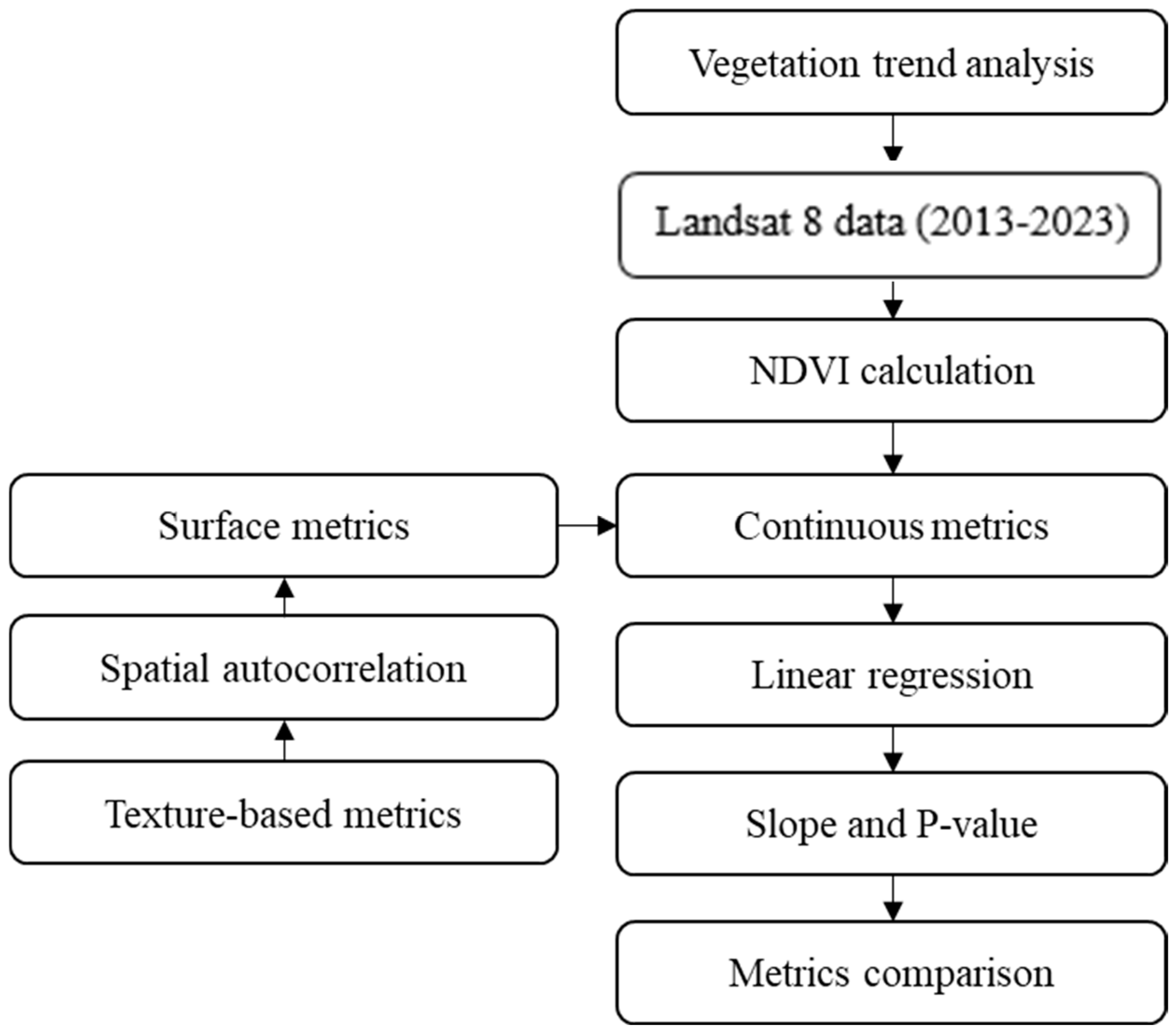
2. Materials and Methods
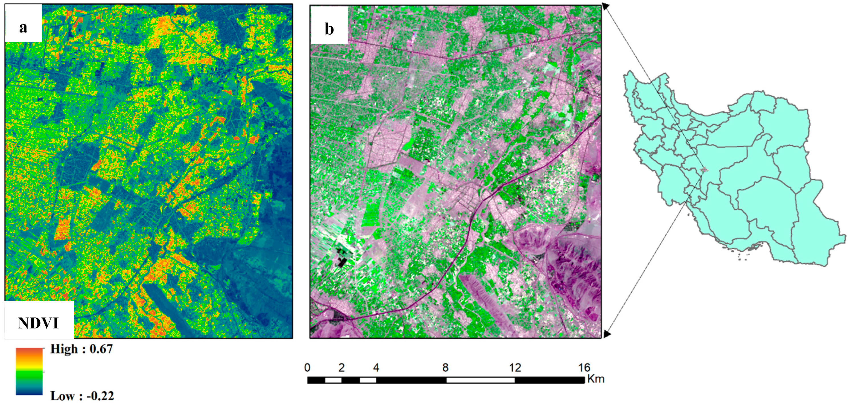
2.1. Study Area
2.2. Spatial Data
2.3. Vegetation Heterogeneity Analysis
2.4. NDVI Calculation
2.5. Local Spatial Autocorrelation Indices
2.6. Surface Metrics
2.7. Texture-Based Measures
2.8. Linear Regression
- -
- Y is the dependent variable (response variable),
- -
- X is the independent variable (predictor variable),
- -
- β is the intercept of the regression line,
- -
- β1 is the slope of the regression line,
- -
- ε represents the error term, which captures the difference between the observed values of Y and the values predicted by the regression line.
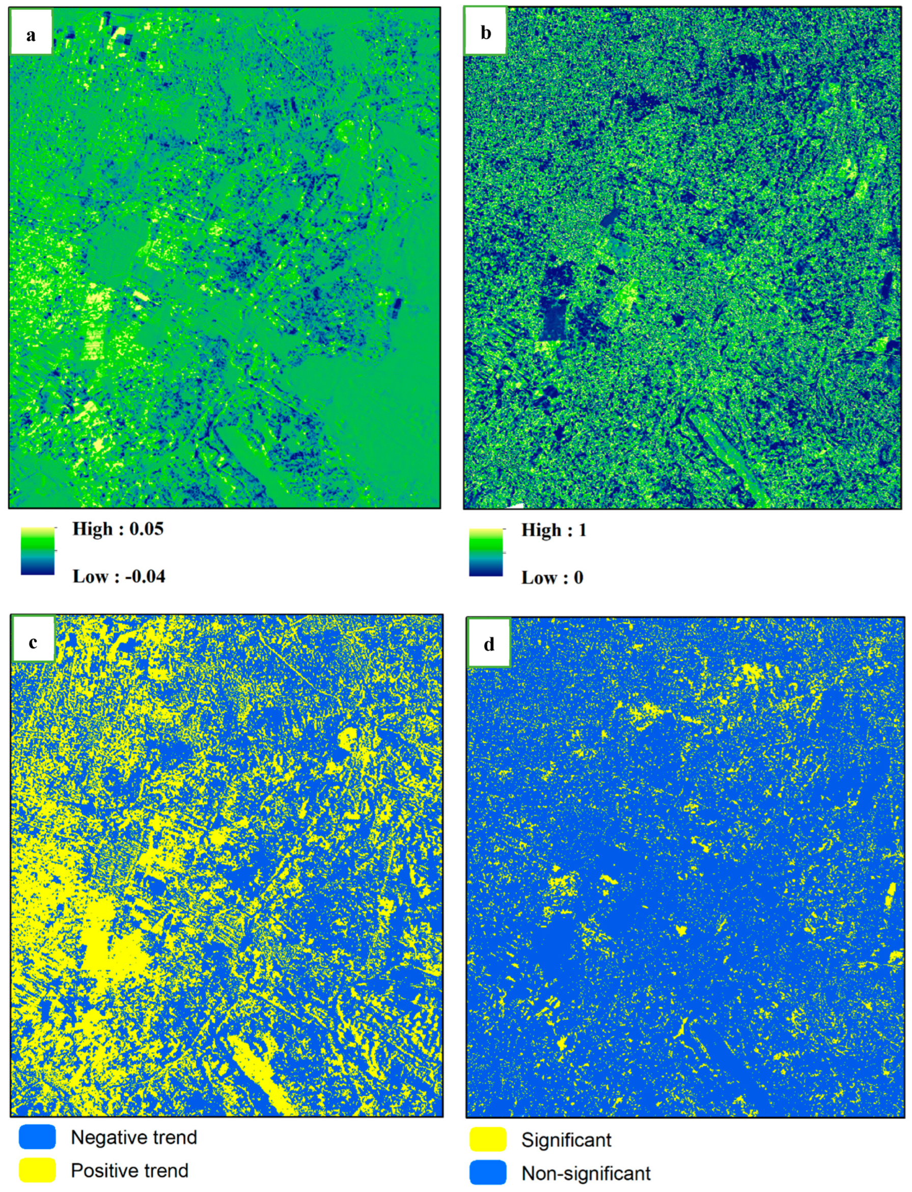
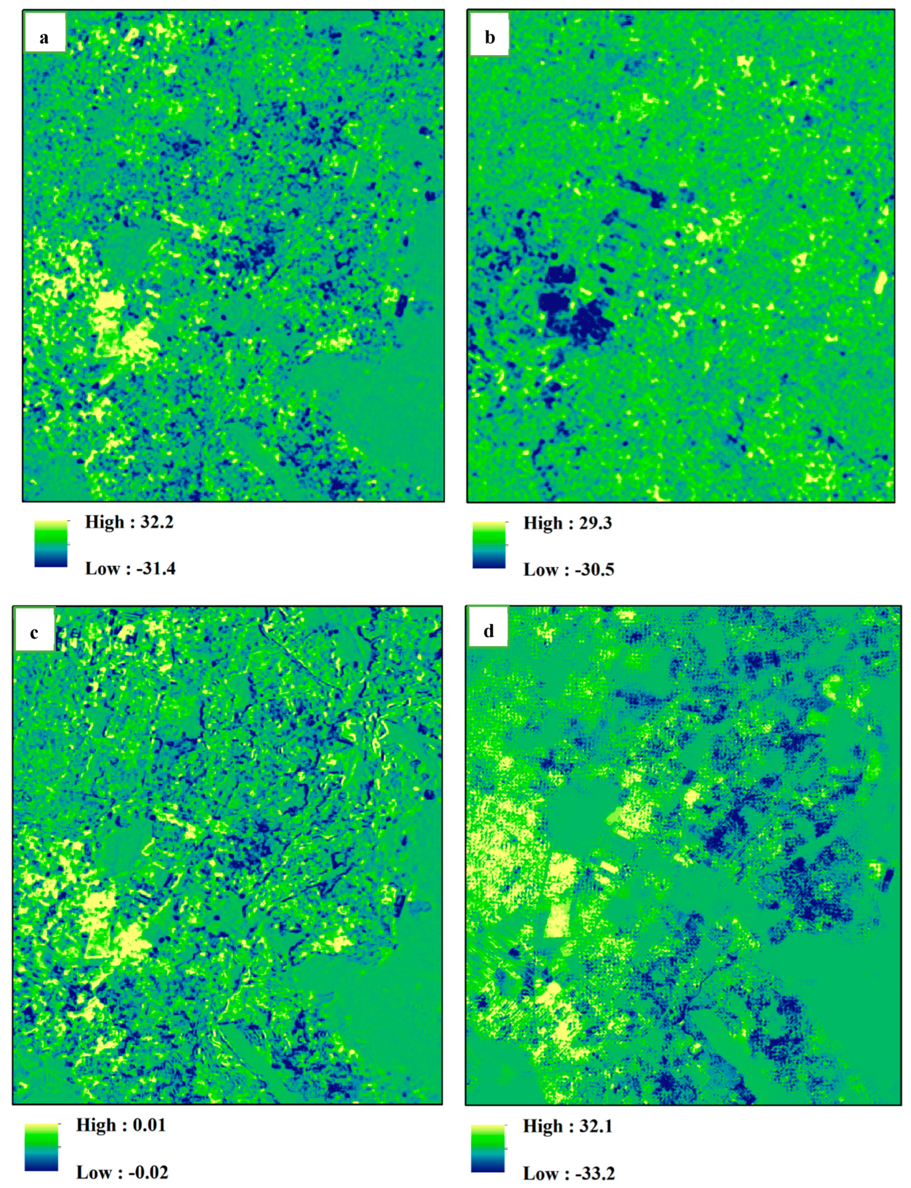
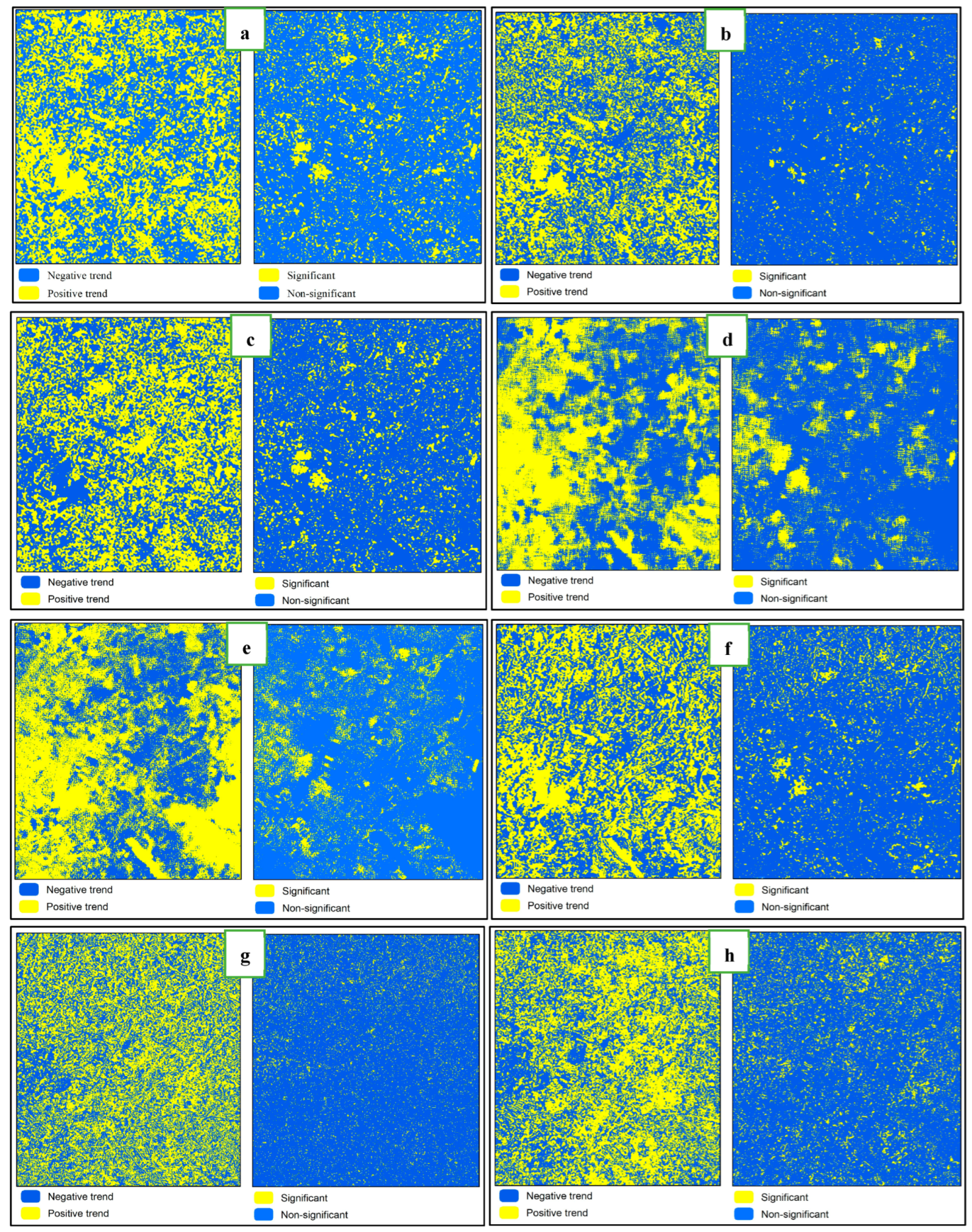
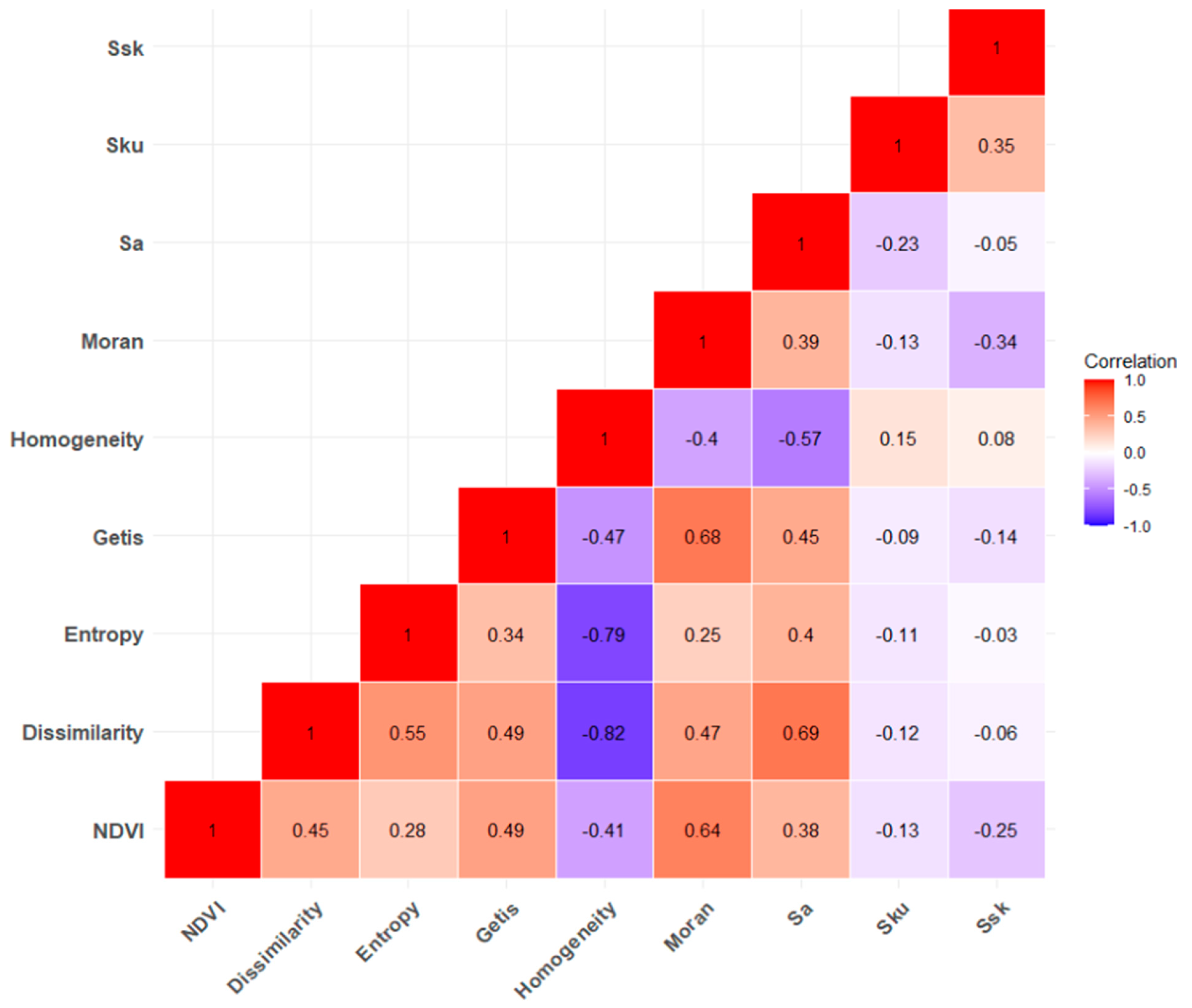
3. Results
Statistical Comparison
4. Discussion
5. Conclusions
Author Contributions
Funding
Data Availability Statement
Conflicts of Interest
References
- Tonetti, V.; Pena, J.C.; Scarpelli, M.D.; Sugai, L.S.; Barros, F.M.; Anunciação, P.R.; Santos, P.M.; Tavares, A.L.; Ribeiro, M.C. Landscape heterogeneity: Concepts, quantification, challenges and future perspectives. Environ. Conserv. 2023, 50, 83–92. [Google Scholar] [CrossRef]
- Kie, J.G.; Bowyer, R.T.; Nicholson, M.C.; Boroski, B.B.; Loft, E.R. Landscape heterogeneity at differing scales: Effects on spatial distribution of mule deer. Ecology 2002, 83, 530–544. [Google Scholar] [CrossRef]
- Turner, M.G.; Donato, D.C.; Romme, W.H. Consequences of spatial heterogeneity for ecosystem services in changing forest landscapes: Priorities for future research. Landsc. Ecol. 2013, 28, 1081–1097. [Google Scholar] [CrossRef]
- Fahrig, L. Ecological responses to habitat fragmentation per se. Annu. Rev. Ecol. Evol. Syst. 2017, 48, 1–23. [Google Scholar] [CrossRef]
- Wagner, H.H.; Fortin, M.-J. Spatial analysis of landscapes: Concepts and statistics. Ecology 2005, 86, 1975–1987. [Google Scholar] [CrossRef]
- Pickett, S.T.; Cadenasso, M.L. Landscape ecology: Spatial heterogeneity in ecological systems. Science 1995, 269, 331–334. [Google Scholar] [CrossRef] [PubMed]
- Forman, R.T. Land Mosaics: The Ecology of Landscapes and Regions; Cambridge University Press: Cambridge, UK, 1995; Volume 652. [Google Scholar]
- Kupfer, J.A. Landscape ecology and biogeography: Rethinking landscape metrics in a post-FRAGSTATS landscape. Prog. Phys. Geogr. 2012, 36, 400–420. [Google Scholar] [CrossRef]
- Li, J.; Song, C.; Cao, L.; Zhu, F.; Meng, X.; Wu, J. Impacts of landscape structure on surface urban heat islands: A case study of Shanghai, China. Remote Sens. Environ. 2011, 115, 3249–3263. [Google Scholar] [CrossRef]
- Kedron, P.J.; Frazier, A.E.; Ovando-Montejo, G.A.; Wang, J. Surface metrics for landscape ecology: A comparison of landscape models across ecoregions and scales. Landsc. Ecol. 2018, 33, 1489–1504. [Google Scholar] [CrossRef]
- Wu, J.; Shen, W.; Sun, W.; Tueller, P.T. Empirical patterns of the effects of changing scale on landscape metrics. Landsc. Ecol. 2002, 17, 761–782. [Google Scholar] [CrossRef]
- Šímová, P.; Gdulová, K. Landscape indices behavior: A review of scale effects. Appl. Geogr. 2012, 34, 385–394. [Google Scholar] [CrossRef]
- Liu, D.; Hao, S.; Liu, X.; Li, B.; He, S.; Warrington, D. Effects of land use classification on landscape metrics based on remote sensing and GIS. Environ. Earth Sci. 2013, 68, 2229–2237. [Google Scholar] [CrossRef]
- Lausch, A.; Blaschke, T.; Haase, D.; Herzog, F.; Syrbe, R.-U.; Tischendorf, L.; Walz, U. Understanding and quantifying landscape structure–A review on relevant process characteristics, data models and landscape metrics. Ecol. Model. 2015, 295, 31–41. [Google Scholar] [CrossRef]
- Tuanmu, M.N.; Jetz, W. A global, remote sensing-based characterization of terrestrial habitat heterogeneity for biodiversity and ecosystem modelling. Glob. Ecol. Biogeogr. 2015, 24, 1329–1339. [Google Scholar] [CrossRef]
- Park, Y.; Guldmann, J.-M. Measuring continuous landscape patterns with Gray-Level Co-Occurrence Matrix (GLCM) indices: An alternative to patch metrics? Ecol. Indic. 2020, 109, 105802. [Google Scholar] [CrossRef]
- Hall-Beyer, M. Practical guidelines for choosing GLCM textures to use in landscape classification tasks over a range of moderate spatial scales. Int. J. Remote Sens. 2017, 38, 1312–1338. [Google Scholar] [CrossRef]
- Iqbal, N.; Mumtaz, R.; Shafi, U.; Zaidi, S.M.H. Gray level co-occurrence matrix (GLCM) texture based crop classification using low altitude remote sensing platforms. PeerJ Comput. Sci. 2021, 7, e536. [Google Scholar] [CrossRef]
- Rahimi, E.; Barghjelveh, S.; Dong, P. Quantifying how urban landscape heterogeneity affects land surface temperature at multiple scales. J. Ecol. Environ. 2021, 45, 22. [Google Scholar] [CrossRef]
- Michishita, R.; Jiang, Z.; Xu, B. Monitoring two decades of urbanization in the Poyang Lake area, China through spectral unmixing. Remote Sens. Environ. 2012, 117, 3–18. [Google Scholar] [CrossRef]
- Lizarazo, I. Quantitative land cover change analysis using fuzzy segmentation. Int. J. Appl. Earth Obs. Geoinf. 2012, 15, 16–27. [Google Scholar] [CrossRef]
- McGarigal, K.; Tagil, S.; Cushman, S.A. Surface metrics: An alternative to patch metrics for the quantification of landscape structure. Landsc. Ecol. 2009, 24, 433–450. [Google Scholar] [CrossRef]
- Rahimi, E.; Barghjelveh, S.; Dong, P. A comparison of discrete and continuous metrics for measuring landscape changes. J. Indian Soc. Remote Sens. 2022, 50, 1257–1273. [Google Scholar] [CrossRef]
- Fan, C.; Myint, S. A comparison of spatial autocorrelation indices and landscape metrics in measuring urban landscape fragmentation. Landsc. Urban Plan. 2014, 121, 117–128. [Google Scholar] [CrossRef]
- Kowe, P.; Mutanga, O.; Odindi, J.; Dube, T. Exploring the spatial patterns of vegetation fragmentation using local spatial autocorrelation indices. J. Appl. Remote Sens. 2019, 13, 024523. [Google Scholar] [CrossRef]
- Lanorte, A.; Danese, M.; Lasaponara, R.; Murgante, B. Multiscale mapping of burn area and severity using multisensor satellite data and spatial autocorrelation analysis. Int. J. Appl. Earth Obs. Geoinf. 2013, 20, 42–51. [Google Scholar] [CrossRef]
- Rocchini, D.; Metz, M.; Ricotta, C.; Landa, M.; Frigeri, A.; Neteler, M. Fourier transforms for detecting multitemporal landscape fragmentation by remote sensing. Int. J. Remote Sens. 2013, 34, 8907–8916. [Google Scholar] [CrossRef]
- Rahimi, E.; Dong, P. Assessing landscape fragmentation dynamics with fourier transforms. J. Landsc. Ecol. 2024, 17, 97–112. [Google Scholar] [CrossRef]
- Li, J.; Narayanan, R.M. Integrated spectral and spatial information mining in remote sensing imagery. IEEE Trans. Geosci. Remote Sens. 2004, 42, 673–685. [Google Scholar] [CrossRef]
- McGarigal, K.; Cushman, S.A.; Neel, M.C.; Ene, E. FRAGSTATS: Spatial Pattern Analysis Program for Categorical Maps. 2002. Available online: https://research.fs.usda.gov/treesearch/3064 (accessed on 15 January 2025).
- Gustafson, E.J. How has the state-of-the-art for quantification of landscape pattern advanced in the twenty-first century? Landsc. Ecol. 2019, 34, 2065–2072. [Google Scholar] [CrossRef]
- Mondal, P. Quantifying surface gradients with a 2-band Enhanced Vegetation Index (EVI2). Ecol. Indic. 2011, 11, 918–924. [Google Scholar] [CrossRef]
- Higginbottom, T.P.; Symeonakis, E. Assessing land degradation and desertification using vegetation index data: Current frameworks and future directions. Remote Sens. 2014, 6, 9552–9575. [Google Scholar] [CrossRef]
- Yengoh, G.T.; Dent, D.; Olsson, L.; Tengberg, A.E.; Tucker, C.J., III. Use of the Normalized Difference Vegetation Index (NDVI) to Assess Land Degradation at Multiple Scales: Current Status, Future Trends, and Practical Considerations; Springer: Berlin/Heidelberg, Germany, 2015. [Google Scholar]
- Adole, T.; Dash, J.; Atkinson, P.M. A systematic review of vegetation phenology in Africa. Ecol. Inform. 2016, 34, 117–128. [Google Scholar] [CrossRef]
- Eastman, J.R.; Sangermano, F.; Machado, E.A.; Rogan, J.; Anyamba, A. Global trends in seasonality of normalized difference vegetation index (NDVI), 1982–2011. Remote Sens. 2013, 5, 4799–4818. [Google Scholar] [CrossRef]
- Zeng, L.; Wardlow, B.D.; Xiang, D.; Hu, S.; Li, D. A review of vegetation phenological metrics extraction using time-series, multispectral satellite data. Remote Sens. Environ. 2020, 237, 111511. [Google Scholar] [CrossRef]
- da Silva, R.G.; dos Santos, A.R.; Pelúzio, J.B.E.; Fiedler, N.C.; Juvanhol, R.S.; de Souza, K.B.; Branco, E.R.F. Vegetation trends in a protected area of the Brazilian Atlantic forest. Ecol. Eng. 2021, 162, 106180. [Google Scholar] [CrossRef]
- Turner, D.; Clarke, K.; Lewis, M.; Ostendorf, B. Using NDVI dynamics as an indicator of native vegetation management in a heterogeneous and highly fragmented landscape. In Proceedings of the 20th International Congress on Modelling and Simulation, Adelaide, South Australia, 1–6 December 2013. [Google Scholar]
- Li, S.; Xu, L.; Jing, Y.; Yin, H.; Li, X.; Guan, X. High-quality vegetation index product generation: A review of NDVI time series reconstruction techniques. Int. J. Appl. Earth Obs. Geoinf. 2021, 105, 102640. [Google Scholar] [CrossRef]
- Rahimi, E. The Efficiency of Long Short-Term Memory (LSTM) in Phenology-Based Crop Classification. J. Korean Soc. Remote Sens. 2024, 40, 57–69. [Google Scholar]
- Forkel, M.; Carvalhais, N.; Verbesselt, J.; Mahecha, M.D.; Neigh, C.S.; Reichstein, M. Trend change detection in NDVI time series: Effects of inter-annual variability and methodology. Remote Sens. 2013, 5, 2113–2144. [Google Scholar] [CrossRef]
- Huang, S.; Tang, L.; Hupy, J.P.; Wang, Y.; Shao, G. A commentary review on the use of normalized difference vegetation index (NDVI) in the era of popular remote sensing. J. For. Res. 2021, 32, 1–6. [Google Scholar] [CrossRef]
- Firoozi, F.; Mahmoudi, P.; Jahanshahi, S.M.A.; Tavousi, T.; Liu, Y. Evaluating various methods of vegetative cover change trend analysis using satellite remote sensing productions (case study: Sistan Plain in Eastern Iran). Carpathian J. Earth Environ. Sci. 2020, 15, 211–222. [Google Scholar] [CrossRef]
- Beck, H.E.; McVicar, T.R.; van Dijk, A.I.; Schellekens, J.; de Jeu, R.A.; Bruijnzeel, L.A. Global evaluation of four AVHRR–NDVI data sets: Intercomparison and assessment against Landsat imagery. Remote Sens. Environ. 2011, 115, 2547–2563. [Google Scholar] [CrossRef]
- Khormizi, H.Z.; Malamiri, H.R.G.; Kalantari, Z.; Ferreira, C.S.S. Trend of Changes in Phenological Components of Iran’s Vegetation Using Satellite Observations. Remote Sens. 2023, 15, 4468. [Google Scholar] [CrossRef]
- Eisfelder, C.; Asam, S.; Hirner, A.; Reiners, P.; Holzwarth, S.; Bachmann, M.; Gessner, U.; Dietz, A.; Huth, J.; Bachofer, F. Seasonal Vegetation Trends for Europe over 30 Years from a Novel Normalised Difference Vegetation Index (NDVI) Time-Series—The TIMELINE NDVI Product. Remote Sens. 2023, 15, 3616. [Google Scholar] [CrossRef]
- Gholamnia, M.; Khandan, R.; Bonafoni, S.; Sadeghi, A. Spatiotemporal analysis of MODIS NDVI in the semi-arid region of Kurdistan (Iran). Remote Sens. 2019, 11, 1723. [Google Scholar] [CrossRef]
- Najafi, Z.; Fatehi, P.; Darvishsefat, A. Vegetation dynamics trend using satellite time series imagery. Int. Arch. Photogramm. Remote Sens. Spat. Inf. Sci. 2019, 42, 783–788. [Google Scholar] [CrossRef]
- Heshmati, G. Vegetation characteristics of four ecological zones of Iran. Int. J. Plant Prod. 2007, 1, 25–224. [Google Scholar]
- Akhani, H. Halophytic vegetation of Iran: Towards a syntaxonomical classification. Ann. Di Bot. 2004, 4, 65–82. [Google Scholar]
- Landsat, E. Landsat 8-9Operational Land Imager (OLI)-Thermal Infrared Sensor (TIRS) Collection 2 Level 2 (L2) Data Format Control Book (DFCB); United States Geological Survey: Reston, VA, USA, 2020. [Google Scholar]
- Frazier, A.E.; Kedron, P. Landscape metrics: Past progress and future directions. Curr. Landsc. Ecol. Rep. 2017, 2, 63–72. [Google Scholar] [CrossRef]
- Bolliger, J.; Wagner, H.H.; Turner, M.G. Identifying and quantifying landscape patterns in space and time. In A changing World: Challenges for Landscape Research; Springer: Berlin/Heidelberg, Germany, 2007; pp. 177–194. [Google Scholar]
- Nolè, G.; Lasaponara, R.; Lanorte, A.; Murgante, B. Quantifying urban sprawl with spatial autocorrelation techniques using multi-temporal satellite data. Int. J. Agric. Environ. Inf. Syst. (IJAEIS) 2014, 5, 19–37. [Google Scholar] [CrossRef]
- Yang, Y.; Wang, S.; Bai, X.; Tan, Q.; Li, Q.; Wu, L.; Tian, S.; Hu, Z.; Li, C.; Deng, Y. Factors affecting long-term trends in global NDVI. Forests 2019, 10, 372. [Google Scholar] [CrossRef]
- Getis, A.; Ord, J.K. The analysis of spatial association by use of distance statistics. Geogr. Anal. 1992, 24, 189–206. [Google Scholar] [CrossRef]
- Anselin, L. Local indicators of spatial association—LISA. Geogr. Anal. 1995, 27, 93–115. [Google Scholar] [CrossRef]
- Smith, A.C.; Dahlin, K.M.; Record, S.; Costanza, J.K.; Wilson, A.M.; Zarnetske, P.L. The geodiv r package: Tools for calculating gradient surface metrics. Methods Ecol. Evol. 2021, 12, 2094. [Google Scholar] [CrossRef] [PubMed]
- Frazier, A.E. Surface metrics: Scaling relationships and downscaling behavior. Landsc. Ecol. 2016, 31, 351–363. [Google Scholar] [CrossRef]
- Hofmann, S.; Everaars, J.; Schweiger, O.; Frenzel, M.; Bannehr, L.; Cord, A.F. Modelling patterns of pollinator species richness and diversity using satellite image texture. PLoS ONE 2017, 12, e0185591. [Google Scholar] [CrossRef]
- St-Louis, V.; Pidgeon, A.M.; Kuemmerle, T.; Sonnenschein, R.; Radeloff, V.C.; Clayton, M.K.; Locke, B.A.; Bash, D.; Hostert, P. Modelling avian biodiversity using raw, unclassified satellite imagery. Philos. Trans. R. Soc. B Biol. Sci. 2014, 369, 20130197. [Google Scholar] [CrossRef] [PubMed]

| Date | Path | Row | Satellite | Sensor | Resolution |
|---|---|---|---|---|---|
| 30 July 2013 | 164 | 37 | Landsat 8 | OLI | 30 m |
| 22 August 2014 | 164 | 37 | Landsat 8 | OLI | 30 m |
| 5 August 2015 | 164 | 37 | Landsat 8 | OLI | 30 m |
| 7 August 2016 | 164 | 37 | Landsat 8 | OLI | 30 m |
| 10 August 2017 | 164 | 37 | Landsat 8 | OLI | 30 m |
| 13 August 2018 | 164 | 37 | Landsat 8 | OLI | 30 m |
| 16 August 2019 | 164 | 37 | Landsat 8 | OLI | 30 m |
| 18 August 2020 | 164 | 37 | Landsat 8 | OLI | 30 m |
| 18 June 2021 | 164 | 37 | Landsat 8 | OLI | 30 m |
| 8 August 2022 | 164 | 37 | Landsat 8 | OLI | 30 m |
| 11 August 2023 | 164 | 37 | Landsat 8 | OLI | 30 m |
| Metric | Name | Equation |
|---|---|---|
| Ssk | Surface Skewness | |
| Sku | Surface Kurtosis | |
| Sa | Average Roughness |
| Metric | Measure | Value Range | Expected Relationship * | Equation |
|---|---|---|---|---|
| Dissimilarity | Inversely related to homogeneity. | ≥0 | H~X | |
| Entropy | Shannon-diversity. High when the pixel values of the GLCM have varying values. | ≥0 | H~X | |
| Homogeneity | A measure of homogenous pixel values across an image. | ≥0; ≤1 | H~−X |
Disclaimer/Publisher’s Note: The statements, opinions and data contained in all publications are solely those of the individual author(s) and contributor(s) and not of MDPI and/or the editor(s). MDPI and/or the editor(s) disclaim responsibility for any injury to people or property resulting from any ideas, methods, instructions or products referred to in the content. |
© 2025 by the authors. Licensee MDPI, Basel, Switzerland. This article is an open access article distributed under the terms and conditions of the Creative Commons Attribution (CC BY) license (https://creativecommons.org/licenses/by/4.0/).
Share and Cite
Rahimi, E.; Jung, C. Analyzing Vegetation Heterogeneity Trends in an Urban-Agricultural Landscape in Iran Using Continuous Metrics and NDVI. Land 2025, 14, 244. https://doi.org/10.3390/land14020244
Rahimi E, Jung C. Analyzing Vegetation Heterogeneity Trends in an Urban-Agricultural Landscape in Iran Using Continuous Metrics and NDVI. Land. 2025; 14(2):244. https://doi.org/10.3390/land14020244
Chicago/Turabian StyleRahimi, Ehsan, and Chuleui Jung. 2025. "Analyzing Vegetation Heterogeneity Trends in an Urban-Agricultural Landscape in Iran Using Continuous Metrics and NDVI" Land 14, no. 2: 244. https://doi.org/10.3390/land14020244
APA StyleRahimi, E., & Jung, C. (2025). Analyzing Vegetation Heterogeneity Trends in an Urban-Agricultural Landscape in Iran Using Continuous Metrics and NDVI. Land, 14(2), 244. https://doi.org/10.3390/land14020244