Article

Loving and Healing a Hurt City: Planning a Green Monterrey Metropolitan Area

by
Rob Roggema
1,*,
Igor Ishi Rubio Cisneros
1,2,
Rodrigo Junco López
1,
Paulina Ramirez Leal
1,
Marina Ramirez Suarez
1 and
Miguel Ortiz Díaz
1
1
Tecnológico de Monterrey, School of Architecture, Art and Design, Campus Monterrey, Monterrey 64849, Mexico
2
Centro de Estudios Parlamentarios, Universidad Autónoma de Nuevo León, Monterrey 64290, Mexico
*
Author to whom correspondence should be addressed.
Land 2025, 14(1), 164; https://doi.org/10.3390/land14010164
Submission received: 5 December 2024 / Revised: 4 January 2025 / Accepted: 13 January 2025 / Published: 14 January 2025

Abstract

:
In many conurbations, the pressure on the quality of living increases and affects the most vulnerable human and non-human populations the most. This article describes a proposal for the mapping and design investigation of how a green metropolis can be developed. The approach distinguishes between the landscape producing pain, the ways of healing, and the opportunities to create environments that people can love. This approach reveals concrete and widespread pain in the metropolis, such as impacts on natural landscapes (rivers and mountains), air pollution, ecological degradation, and hydrological disconnections. The strategy to remediate this pain is to uncover hidden and altered creeks and rivers, creating an abundant zone of ecological space around them before human activities and urbanization change the land uses. In addition to this, specific design principles have been developed for hydro-ecological corridors, water retention, green islands, and greenways. Designs for these places can be replicated to support a healing strategy in the Monterrey Metropolitan Area (MMA). Each place creates an environment that the urban residents will appreciate and preserve. The approach to analyzing landscape pain, designing healing strategies, and promoting local places of love can be applied to enhance the quality of life for many urban residents and non-human ecologies in metropolitan areas around the globe.

1. Introduction

With more people living in cities than ever before, specifically, more than 50% [1] since 2014, with this figure expected to rise to 68% by 2050 [2], it is paramount to create healthy, clean, and livable conditions for urban residents. Many live in vulnerable communities under challenging conditions, so their health implications pose substantial problems in the urban environment. More than 40% of people living in cities have no access to safe sanitation and sufficient drinking water, more than 90% breathe polluted air, and many are exposed to epicenters of disease transmission, including vector-borne diseases [3].
Urbanization and development impact urban life in many ways. First, cities are the victims of climate change through rising temperatures and sea levels, and extreme events that cause floods, droughts, and storms, which may increase diseases in cities. They impact essential services, e.g., livelihoods, health, infrastructure, and housing [4]. Simultaneously, cities cause climate change through their deployed activities, such as buildings and transport, which account for an estimated 60–70% of carbon emissions [5,6], making urbanization and urban development a critical factor in mitigating carbon emissions potentially [7,8,9].
In detail, land use changes in cities, from green and open surfaces to high percentages of asphalt and concrete, add considerably to and even cause an increase in urban heat. The larger the city, the more extensive the urban heat will be. Besides this, anthropogenic factors such as the energy used in buildings and transportation add to the heat in urban centers [10]. Also, cities are the main places responsible for the depletion of resources, such as materials and energy, oil, water, and food, causing waste, air pollution, and congestion, and increasing emissions levels [11]. The use of these materials leads to significantly higher levels of pollution, such as air [12], solid waste [13], and water [14]. Many negative urban and climate impacts mentioned above unevenly affect the most vulnerable populations [15].
Urbanization impacts both human health and the capacities of (urban) ecosystems [16] that are under threat and then degraded [17], leading to disruptions of hydrological systems [18]. This footprint can be seen as a multiplier problem because the role of natural ecosystem services creating healthier conditions for humans cannot mitigate health issues due to their degradation.
The role of a more emotional attitude during the planning for green cities is underestimated. Predominantly, the rational brain is used for planning purposes, while the emotional brain, or how the environment is perceived and ‘felt’, is neglected. If the focus of urban planning policies remains on planning operations, the driving forces to change cities into being adaptive or nature-driven will continue to be weak to face dominant economic and natural laws. In most cases, cities take ‘green’ as an add-on local to urban developments, often ending up as isolated pieces of green spaces.
This article explores the benefits that arise when an emotional approach is added to the planning of physical green systems and structures. We test this idea with a mapping and design-led research approach to the metropolis of Monterrey in northeastern Mexico, a city suffering from serious climatic impacts, a city with a strong industrial character, and an economically driven mentality. The abundance of impacts on urban life in the Metropolitan Region makes Monterrey a good case for testing the role of emotions in spatial and urban planning.

2. Background

2.1. Urban Problems

In 2020, there were 1934 metropolises with more than 300,000 inhabitants, representing approximately 60% of the world’s urban population [19]. According to the Oxford dictionary and Collins English dictionary, a metropolis is “a large city or conurbation which is a significant economic, political, and cultural area for a country or region, and an important hub for regional or international connections, commerce, and communications” [20,21]. Although some claim that more condensed and large metropolises are greener [22], supporting sustainability (e.g., reduced carbon emissions), it does not necessarily create a greener, natural, or more biophilic city [23]. Instead, larger cities tend to be less green [24]. Large cities in high-income countries have adequate green provisions compared to states under less privileged circumstances [25]. We live in difficult times [26] as the climate changes faster, more unpredictably, and potentially more impactfully. Cities are the cause of and the possible solution to reducing harmful greenhouse gasses that raise global temperatures [27].
Amongst the most significant problems caused and accelerated by urban activities are the degradation of ecosystems and biodiversity loss [28]. Moreover, cities contribute to the depletion of natural resources [29,30], have significant impacts on human health [31], are the main cause of pollution [32], lack sufficient spaces for improving physical health [33,34], and contribute unevenly to mental health issues [35,36]. Extreme hot temperatures and the establishment of hard surfaces in cities lead to the effect of urban heat islands, which are responsible for 4% of deaths during summer. Europe could prevent up to 2664 premature deaths, providing 30% of green cover [37]. People who suffer most from climate disasters and overheating conditions are often the most vulnerable but the least responsible for causing climate change [38]. Cities have become places where the privileged citizens are closest to nature with more available resources, have easier access to healthcare, escape from floods, and have alternatives to withstand extreme weather conditions.
Many cities have developed plans and policies to green the city, employing physical planning to tackle similar problems. For example, many cities experiment with green infrastructure, addressing the role of green infrastructure in mitigating environmental issues such as climate change and air pollution, its benefits for ecosystems and biodiversity, and the social and economic advantages [39], although a limited amount of only one-fifth of research embraces social and economic factors [40]. Green infrastructure is otherwise mainly structured by a hybrid hydrological network, linking relict green areas with the built environment to provide ecological functions [41]; this only partially mitigates environmental problems.
In several cities, a specific aim to focus on urban ecology is considered to ”support resilience-orient development and highlight a synergetic response with an evolutionary form of multi-disciplinary sustainability” [42]. However, for urban planners, this is a significant consideration for their practices, but integrating information about the surroundings may be limited to knowledge and awareness [43]. Furthermore, the uptake of urban ecological principles is not stimulated due to the societal loss of the appreciation of ecosystem services such as improving air quality, reducing the urban heat islands, and enhancing urban health, groundwater recharge, and urban water retention [44]. Although the beneficial role of urban ecology has repeatedly been acclaimed in research, its practical use in urban development and planning processes is still limited.
The need for adaptation to climate change is profound in larger cities, and despite the fact that this has been defined as a spatial challenge [45], many climate adaptation policies are developed at the national level and only 15% of cities report any adaptation initiatives, while 18% are planning towards adaptation policy [46]. The complications of adapting demonstrate the practical difficulties and a problematic success rate in implementing physical measures to attenuate climate impacts. Many cities need better planning for impactful solutions to transform their industrial variants. Cities developing under an industrial scope find it challenging to move toward a symbiotic future because of the technical features of green infrastructure and the need for more awareness of urban ecology within climate policies [47].
Cities aim to tackle these disparities, mainly by physical planning approaches, which are partly successful locally. Experiences are equally essential to fulfill the needs and desires of urban residents [48,49], an aspect often neglected in current urban planning practice. Emotional approaches to planning have been used to deepen the greening efforts in urbanized areas.

2.2. Emotions and Urban Planning

Every resident in the city (and outside of it as well), relates to its environment emotionally. The complex and varied ways humans experience the city make it urgent for urbanists to recognize, listen, and respond to people’s feelings [50]. While this is discussed in sociology [51,52], psychology [53,54], anthropology [55], and geography [56], in spatial and urban planning, it seems to be underused. Urban planning is driven by values, which are an emotional and mental representation of things and situations, hence urban planners and designers follow these values and translate these into urban designs, which provide each city with its own coherent identity, directed by those values [57]. In reverse, our environment is experienced emotionally and has an affective connection to the place [58]. The emotional connection people have is primarily related to their environment and the physical connection comes second. However, this emotional connection is not always self-explanatory. Love or pain can mean many different things and depends on the individual, as the poet Luiz Vaz de Camoes expressed in the 16th century in his poem [59], elaborating on the specific and personal role emotions can play. He highlights both the difficulty of incorporating emotions for instance in urban planning, but also illuminating the power emotions can have in life in general, and urban life in particular:
Love is a fire that burns unseen;
It’s a wound that hurts and doesn’t feel;
It is discontented contentment;
It is a pain that goes unnoticed without hurting.
It’s not wanting more than wanting well;
It’s a lonely walk between us;
It’s never to settle for happiness;
It is a care that gains in losing itself.
It’s wanting to be trapped by will;
It’s serving those who win the winner;
Have someone kill us, loyalty.
But how to cause can your favor
In human hearts friendship,
If so, contrary to itself, is it the same love?
The concept of geography causing emotions explains our experience with our environment. In a world where pain and pleasure occur, although never clearly or consistently, we attribute emotional agency to how our environment appears to us [60]. In an urban context that is rapidly increasing in size, both in the area it occupies, the number of built constructions and the number of people living there, the mental life of individuals urges them to protect themselves from a possible sensory overload, and people (the metropolitan type) become more reserved in their relationships [61]. Inhabitants of larger cities therefore experience the sensuousness of the municipality as risks and rewards [62] or pleasure and pain [63] offered by the city and its natural environment. People interpret their surroundings with all their senses, emphasizing (visual) seascapes, (acoustic) soundscapes, smellscapes, tastescapes, and touchscapes [64]. Architects such as Luis Barragán use these sensory features to create spaces that evoke emotions. A breath of air, the movement of a small animal, or the type of light directly influences the design of architectural spaces [65].
The use of emotions in architecture can be directly related to urban identity. When local characteristics are used in the design of cities, their identity is preserved clearly. The state of cultural preservation is critical because, with globalization, the notion of identity has become scarcer and fragile [66]. In architecture and urbanism, the image of the city, with its key urban elements like buildings, streets, and squares [67], allows people to attach the continuous shaping of the urban patterns to their environment [68]. This design gives people a sense of belonging, which is something people intrinsically strive for, helping them feel secure and connected [69]. This design intends to associate people’s emotions with a positive landmark in the topography by strengthening their memories [70].
Research has revealed that urban dwellers feel happier in places with access to green and nature, cultural facilities, healthcare, public amenities (e.g., sewage and water supply), and public space [71]. Moreover, people have an innate love for nature and a high survival capacity [72]. Therefore, could nature be experienced as the common denominator that enhances urban identity and works as an attractor of common values? Natural environments are appreciated at a higher level than their urban counterparts, as depicted in the biophilia hypothesis [73]. Many environmental psychologists studying the interplay between people, places, and the environment [74] have concluded that nature has a positive impact on mental fatigue, stress, and emotional well-being [75,76,77] due to its therapeutic features [76,78]: fascination, novelty, coherence, and compatibility [76]. Moreover, nature has a positive effect on the human capacity to recover; patients with a view on nature were discharged from hospital faster and required less strong painkillers [79]. Finally, traditional knowledge indicates that the healing of altered landscapes benefits from core values such as sustainability, reciprocity, and adaptability to fully recover naturally [80]. The interchange between health improvements of the (altered) landscape and humans is key. It shows that the overall improvement of natural systems and structures in the city positively impacts human experiences and the capacity to heal the environment.
Still, it is equally essential to use emotional experiential contributions to identify and create effective solutions for current urban problems. The research carried out for the Green Metropolis of Monterrey aims to offer a methodological approach to integrate emotions and experiences in physical planning.

2.3. Earth Emotions

History can be divided into geological periods; this is also called geo-chronology. The duration and characteristics of former eras are based on stratigraphy, the sequence of rock layers found worldwide. Since the Holocene, a geological era that started 11,700 years ago, human activities have been a more significant ‘determiner’ of the epoch than the geological processes [81,82]. In the future, another informal possibility is the era coming after the Anthropocene [83,84], the Symbiocene [85,86,87,88,89]; this could be a period without impacts of human activity on the planet. Everything humans do will be integrated within the support systems of all life and will leave no trace. In a recent theory [85,86,87,88,89], this prospective period is linked to environmental emotions, proposing a vocabulary for how the environment is perceived in perilous times of climate change and resource depletion. The concept of attributing emotions to the earth aims to give (new) words to the pain humans experience. In the Anthropocene, humans have exploited and altered the world to an extent that is acclaimed as an informal geological era. The emotions this evokes range from sadness, anger, and homesickness. In the Symbiocene, these feelings are proposed to be resolved and transformed into a healing process. When humans learn to live in symbiosis with their natural environment, their feelings will turn into love and affection.

3. Materials and Methods

3.1. Monterrey Metropolitan Area (MMA)
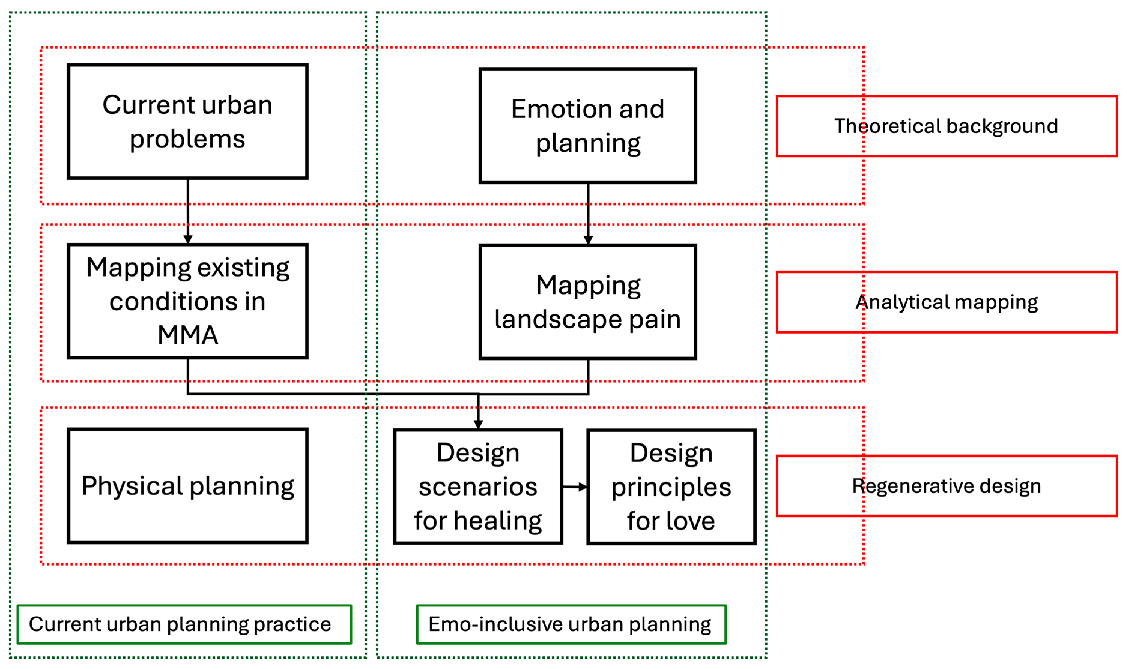
The area of study is the region of Monterrey (Figure 1), the second largest city of Mexico, located in the northeast of the country. The metropolis marks the transition of the Sierra Madre Oriental in the west–southwest to the northeastern arid plain of Tamaulipas. The region is the southernmost part of the Rio Grande (or Rio Bravo) watershed, eventually flowing into the Gulf of Mexico. The city is built in a valley surrounded by mountains and isolated mountainous hills. This topographical condition causes high temperatures in summer, easily above 40 °C, and many days with one of the worst air qualities on Earth. In 2020, the metropolis was inhabited by a little more than 5.3 million people, divided into 15 municipalities [90]. The total area considered is roughly 70 × 70 km.
Historically, the city of Monterrey was founded on an industrial basis, and ever since, industrialization has continued to the present day. Large companies such as Cemex (cement), Pemex (petrol), Femsa (soft drinks, beer, and food), and Ternium (steel), to name a few, have determined both the image of the city as well as the mentality of the people. Due to the rapid urban growth of the city and its industries, resource depletion, pollution of the air, and water scarcity, the city faces significant environmental problems related to air and water quality, ecological degradation, and a strong desire to drive cars. Moreover, due to its location close to the American border, logistics and transportation, and the use of large trucks, it is putting pressure on the regional road network and impacts the environment through air and noise pollution. All these factors profoundly affect how the city is perceived visually and how inhabitants and visitors experience the city.

3.2. Methods

For this research, we used a mixed methods approach. The different parts and steps are reflected in Figure 2. First, the theoretical background of the current urban planning practice and emotion in planning were investigated. In the second phase, we carried out an analytical mapping of the existing conditions and the landscape pain. The research concluded with a research-by-design process for proposing creative spatial scenarios, strategies, and concrete design principles.
Firstly, to identify the current urban problems and how these are solved, an extensive internet search requires using a range of sites such as Google Scholar, Science Direct, JSTOR, and Web of Science. Over 400 articles were scanned using keywords such as urban planning, urban design, spatial planning, spatial policy, sustainability, regeneration, landscape planning, landscape urbanism, and emotion. Out of these articles, only very few (e.g., less than five) correlated planning approaches with emotions, often focusing on emotional responses in planning processes. The analysis helped to layer the different urban problems according to their spatial scale (regional, neighborhood, and local), their types of problems (environmental, functional, and visual), and the perception or emotional connotations.
Secondly, the existing conditions in the Monterrey Metropolitan Area (MMA) have been mapped using various available sources (Table 1). The following themes and topics were part of this spatial investigation: water systems, elevation, ecology, landscape, soil and geology, amount of green space, urban growth, densities, and climate impacts.
Thirdly, we not only depend on technical mapped information of the region, but we also seek more emotional–psychological ways to describe the current problems as experienced by the population [83,84]. Therefore, we used the work of Glenn Albrecht, who developed a new vocabulary to give words to these feelings [85,86,87,88,89]. The main vocabulary has been organized according to the role of each verb in describing the emotion as painful, a healing process, or a form of love and affection (Table 2). Undoubtedly, other emotions are also relevant in an urban context, such as fear, anxiety, or hope. Given the time constraint in this research, we had to limit the number of emotions to these three general ones.
Fourthly, a second mapping exercise was undertaken to identify the elements of pain in the region. In this first attempt to map the landscape pain, the research team estimated the elements that people may experience as painful, such as infrastructural barriers, extra large buildings, impaired mountains and natural reserves, air pollution, and disrupted waterways. In this spatial investigation, we chose not to consult urban dwellers or residents to collect sufficient data. The purpose was to illustrate the mapping of estimated landscape pain, as a first step towards a more rigorously underpinned measuring of landscape pain emotions. The maps and the sources used are summarized in Table 3.
Fifth, the design phase of the research consisted of two parts. In the first part, four workshops were organized with the research team and the client, who developed future scenarios for the metropolis of Monterrey. In these workshops, the client (Fondo Ambiental Metropolitano de Monterrey) and the research team (six academics with backgrounds in urban planning, urbanism, landscape architecture, and environmental sciences) intensively participated, discussed the prelim results and translated these into four future scenarios (see Section 4.4). These scenarios were focused on the development of healing strategies. In the end, four were selected as distinct enough to discuss the desired green metropolis, with two scenarios focusing on limitless and regular urban growth, respectively, and two on the transformative regreening and disruptive greening, reversing urbanity. The development of a regional spatial strategy on how to grow into a greener metropolis was also part of these workshops, and the objective was to identify the process of green urban development. The second part focused on creating design principles that visualize urban environments that residents could embrace, affectionate, and love.
These design principles have been created differently and for several typical spaces in the metropolis. Several design principles were the subject of design workshops with the research team; others have emerged out of the work of four Master theses by students of Landscape Architecture at Delft University of Technology, and some have been created by students of the Master of Architecture and Urban Design at Tecnológico de Monterrey. Some typical spaces were subject to the development of such a design principle, such as the eco-hydrological corridors, green streets, urban forests, urban gardens, rivers and creeks, retention basins, sub-metro greenways, avenues, green islands (transformation of large parking areas), and green roofs on industrial sites. For each of these sites, one or more visualizations were designed. These design principles have been created as primers for local co-design processes in neighborhoods and are seen as too general and abstract to discuss directly with residents. In a follow-up process, the design principles will be used to start the design process of concrete sites involving the local communities.

4. Results

4.1. Discrepancy Between the Natural Qualities and Urban Impacts

The mapping of the existing conditions of the Monterrey Metropolitan Area highlights the appearance of a natural landscape of mountains, forests, creeks, and rivers. Still, it simultaneously shows an extensive eco-degeneration mainly caused by urban and industrial growth, human impacts, and climate change. Intensive human activities led to a city driven by economics, with more pollution and pressure on the natural landscape over time. The mapping of the existing natural condition also revealed the interdependencies of ecology, water, air, and soil. On the other hand, the maps of urban and human activities show a different perspective; these cause urban heat islands, air pollution, social inequal accessibility of green, and a deficit of green space.

4.2. Need to Distinguish Between the Pain, Healing, and Love

The novel verbs for Earth’s emotions (Table 2) have been analyzed according to the type of reaction. Some of these emotions (terraphtora, tierratrauma, solastalgia, and terrafuria) describe the pain that is experienced, while others (sumbiofact, symbiocene) describe activities that heal the broken environmental and landscape systems or point to an affectionate relationship between people and the environment (love: endomophilia, eutierra, psycoterratic and terranascia). This distinction between pain, healing, and love illuminates the landscape of pain, pointing at ways healing can be achieved, and public spaces, structures, and systems can be created for people to appreciate. The addition of emotions in planning helps to go beyond a tactile understanding of causes and possible solutions. This research revealed that emotional attachment to certain activities, images, and uses of the urban realm represents a deeper, more confronting, and exciting impression of the city than simple land use and mobility patterns can. Hence, the Earth’s emotions [88] (Table 2) are subdivided into three categories:
  • (Landscape) Pain—The painful emotions (visual, emotional, physical, and health) highlight all elements that people experience as unpleasant or hurting. Landscape pain has been identified as the estimated visual and/or environmental problems, in a qualitative analysis, based on the individual mapping of specific topics (Section 4.3).
  • Heal—The healing opportunities were the solutions for the identified problems (pain), in the form of the scenarios and greening strategy (this is a research-by-design and creative step and not derived explicitly from data). These emotions can help to compensate for and repair pain, resolving the environmental or visual pain. This way, healthy landscapes reduce the negative impacts induced. Air and water pollution are reduced to acceptable levels, visual landscape disturbances are removed, and spatial misfits, such as too-large constructions and too-broad infrastructures are reduced in size. The scale at which healing is most effective is at the systems or structural level and at the source of the pain (e.g., emission of toxic pollutants).
  • Love—This is a projection of design principles for several characteristic spaces in the city, for instance where the pain is most felt (heavy infrastructure or visual barriers for example), or where opportunities emerged (hydrological corridors for example). These emotions indicate the transformations of public spaces to make them attractive for the residents (human and non-human) to access, spend time with or in, and appreciate. This goes beyond the reparation of negative impacts (pain) but improves the quality of the direct environment, often at the (hyper)local scale.
Each set of urban activities is ordered into categories for mapping the Monterrey Metropolitan area (Section 4.3).

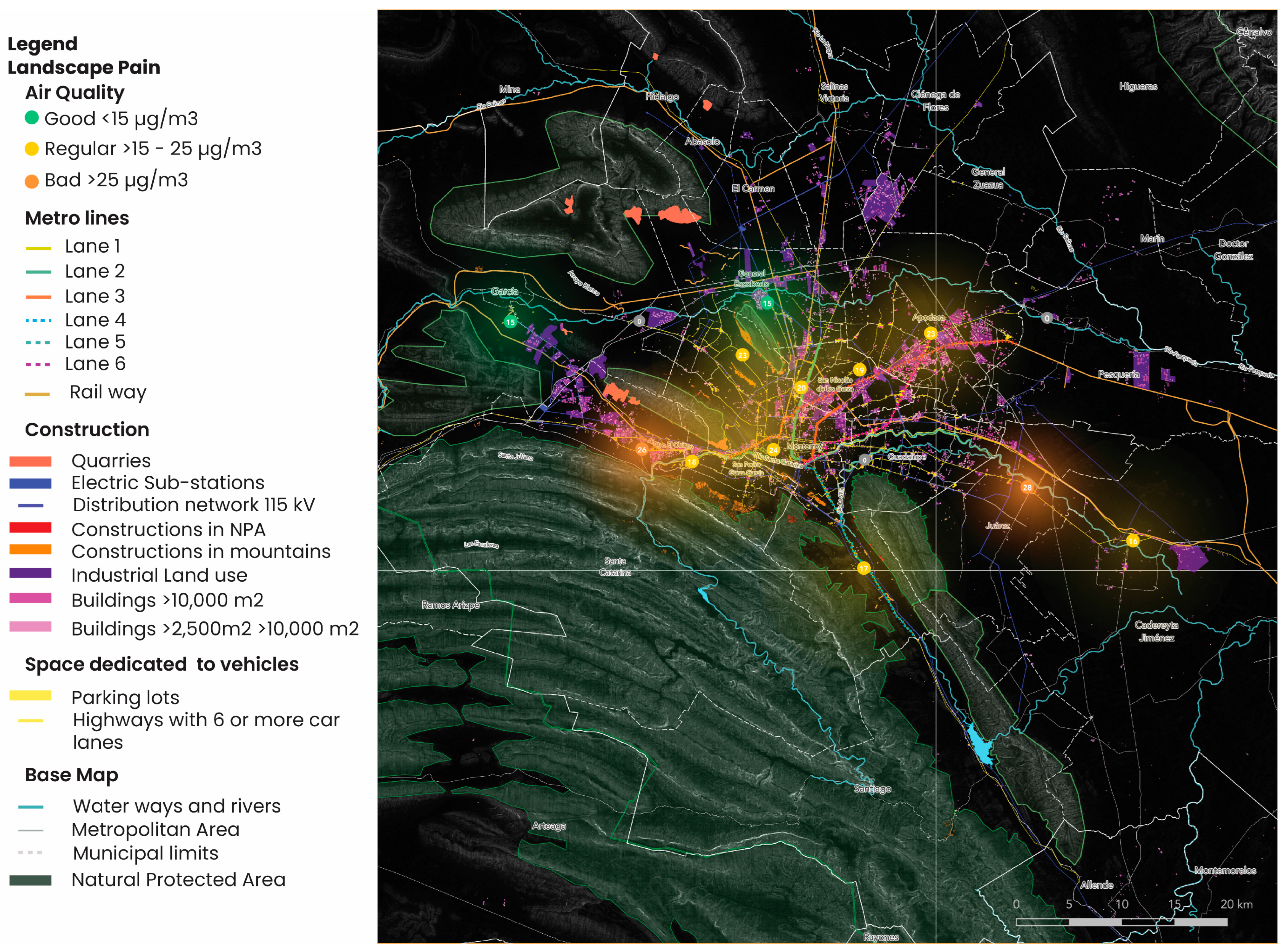
4.3. Landscape Pain Is Widespread

The analysis of the landscape pain in the Monterrey Metropolitan Area is represented on a series of maps integrated in Figure 3. The following topics have been identified:
  • Quarries and constructions in nature reserves. In the Monterrey Metropolitan Area (MMA), 1289 ha. are excavations (quarries) found on slopes in mountain zones. In addition, 29,928 constructions (houses or other buildings) are located on slopes of mountains and hills. Of these constructions, 3497 are in Natural Protected Areas.
  • Green spaces. There is a lack of access to green spaces and a limited amount of green space per person. In the entire Metropolitan Area, including the urban fringes and agricultural land, there is 22.2 m2 of green space per inhabitant. However, these green spaces are not equitably accessible to all inhabitants, and the indicator is not representative of a green city compared to the 51 m2 per capita in Barcelona [95]. At the same time, it is advised to have a minimum of 9.5 m2 of green space per inhabitant [111]. Although this indicator is outdated and is average, while urban areas are composed of very different densities, functionalities, and activities, it still indicates how well cities do. When parks and green spaces in the urban precincts of the Monterrey Metropolitan Area are calculated, there is only a mere 4 m2 of green space per capita.
    Furthermore, applying the 3-30-300 rule [112], the advised 30% of tree cover is only met in 50% of the Monterrey Metropolitan Area, and only 43% of the population has access to a green public space within 300 m or a five-minute walk [113]. For vulnerable groups such as children (25%) and elderly (40%), this accessibility is even lower. This unbalanced distribution of green spaces over the different neighborhoods in the city leads to the most vulnerable urban population living in the hottest conditions, suffering from urban heat [114]. In Monterrey, approximately 40% of the population that faces a medium or high social gap [97] has access to a public green space.
  • Main roads (over six lanes) and surface parking. In the MMA 670 km of highways, over six lanes are found and over 996 ha. for parking, which is two-thirds of the space allocated for public parks. The emissions caused by the cars using this infrastructure are estimated at 7,764,568 tons of CO2/year. This car infrastructure has profound impacts on human health through air pollution [115], soil degradation [116], and a general decline in quality of life [117].
  • Large-size buildings. In the MMA, 972 buildings of over 10,000 m2 and another 7628 between 2500 and 10,000 m2 are found. These buildings, mainly logistics and industrial, have no or a significant deficit of green spaces on and around them. It causes large, uncovered surfaces, which are a primary cause of the urban heat island effect [118,119].
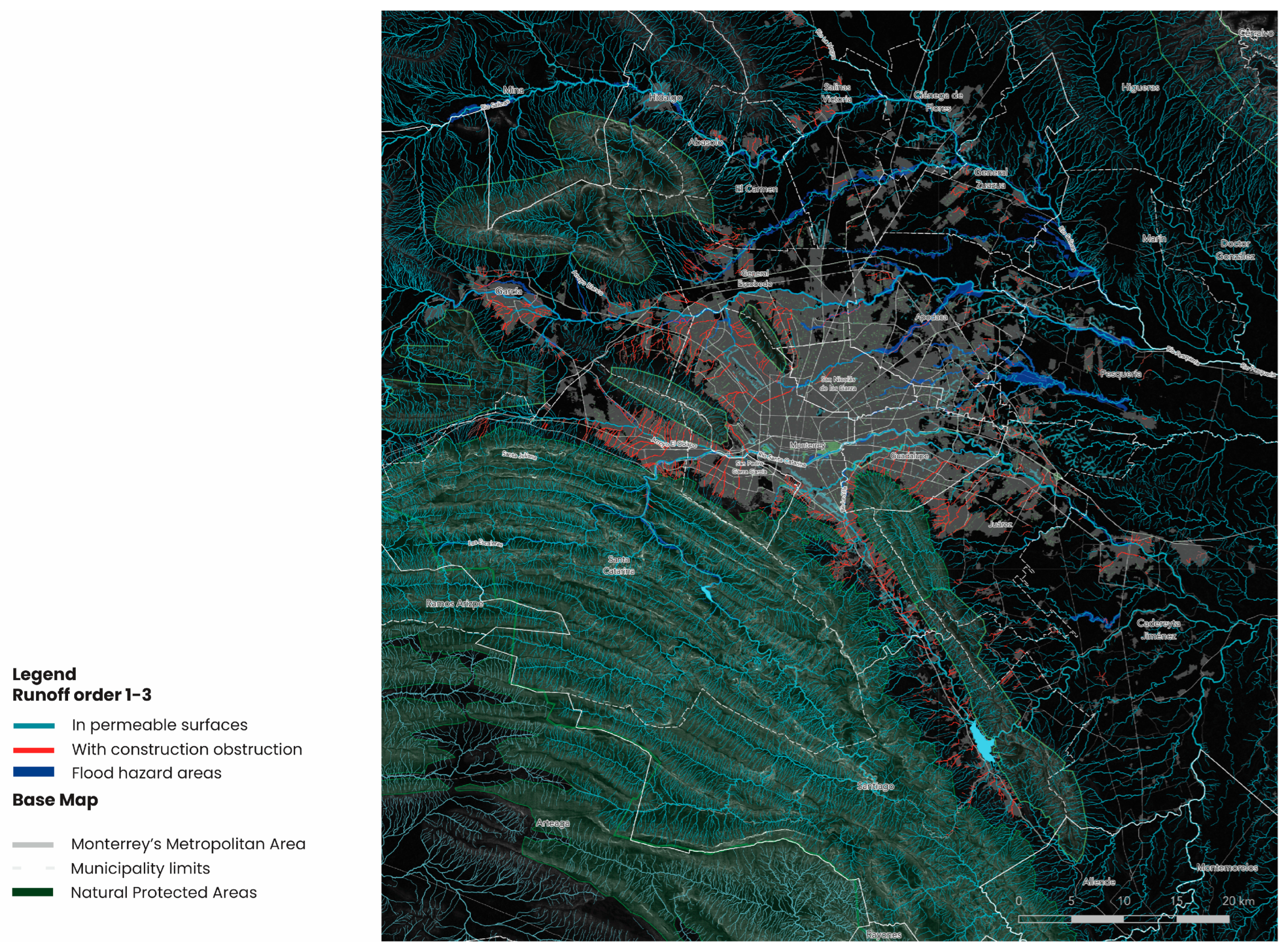
  • Rail tracks and public transport are elevated above ground (metro system). The 411 km of rail tracks provide a noise problem, as many of these lines generate 80–100 dB [120] and 19.3 km of elevated metro lines. The transportation network exaggerates barriers between neighborhoods, rivers, and green spaces, creating problematic underpasses that reduce the views of the mountainous landscape.
  • Polluting industries such as the Pemex refinery emit the majority of PM10 and PM2.5 particles, causing adverse effects on human health and causing life-threatening diseases [121]. It is estimated that, in 2021, 1684 deaths were directly related to air pollution.
Besides the visual and health effects of resorting under the umbrella of landscape pain (Figure 3), there is a strong correlation between places where large concentrations of oversized buildings, the lack of green cover, urban heat islands, and air pollution. This profound impact of landscape pain on air quality and urban heat has severe adverse effects on human and ecological health.
Additionally, the hydrological pain has been investigated. A significant part of waterways that used to flow naturally (e.g., undisturbed finding their way, accompanied by ecological edges, and riparian zones) is currently disturbed by, in total, 17,003 constructions. Their locations are reflected on the map (Figure 4). The disturbances consist of houses, other buildings, or roads that have covered the creeks and rivers. Natural channels are now part of the sewage system, underneath the pavement, and have become invisible. It is no coincidence that the places where the water is disrupted are also the location of local flooding. It has also decreased water quality and interferes with the regulation of the hydrological cycle, which impacts natural ecosystems in a negative way [122].

4.4. Healing

The research-by-design process has revealed different strategies to heal the pain experienced. The emotional attachment to nature and green spaces and its benefits for human health have been taken as the core of the spatial strategy. The experience of hydrological and landscape pain is mitigated by introducing a strong eco-hydrological network. This green-blue network is constructed using two strategies, both capable of healing the experienced pain: developing spatial future scenarios and a sequential planning approach.
The development of spatial scenarios is explicitly not meant to create plans for the future or to enforce decisions, but they explore what-if questions for a long-term imagination to guide the development of the region. In this sense, the scenarios illustrate what might happen if a specific choice guides future urban development. Scenario planning [123,124,125,126] designs four possible visions for the regional future. This way, distinct and coherent storylines can be created (Figure 5). Two of these, the ‘BAU scenario’ and the ‘ReConquer the City’ scenario, are discussed here. The other two are called ‘we don’t care’ and ‘A healing metropolis’.
The BAU scenario describes an uncontrolled growth of the city, eventually reaching a population of up to 10 million people (nearly doubling the current population). An ongoing sprawl occupies large parts of the surrounding landscape. This sprawl incorporates small batches of green spaces like parks and sports facilities. The ReConquer the City scenario limits the boundaries of the Metropolitan Area by creating a large green belt around the city as a connected series of ecologically valuable forests, meadows, and landscape parks [127]. In addition to this main green structure inside the urban realm, green retakes part of the urban uses by reconnecting an extensive bio-ecological network along rivers and creeks, including the replacement of impermeable squares and side streets by green spaces and parks, aligning residential roads with trees and covering roofs and facades in green. The natural landscape with its waterways, hills, and mountains forms the basis for this scenario.
If the ReConquer scenario is taken as the basis for future growth, this is because of the benefits it has for physical and mental health, and the intrinsic emotional attachment of humans to nature; the second strategy explores the sequence of planning decisions needed to increase the chances of realizing such a scenario. This approach is based on the so-called landscape first theory [128,129,130,131,132,133,134,135], which emphasizes understanding the natural landscape conditions before implementing other non-human or urban activities. For the Monterrey Metropolitan Area, this means uncovering and reconnecting the hills and mountains with waterways, creeks, and rivers throughout the region and, as a second tier of intervention, providing each of them with an abundant zone for green, ecology, and water retention. As a final stage of spatial transformation, the remaining spaces can be used to accommodate and adapt urban activities to this context (Figure 6). This approach resembles the strategic planning carried out in the 1960s for Monterrey, in which large green landscapes entered deeply into the urban area [136]. This way, the natural network is reestablished. It can bring environmental benefits, such as mitigation of urban heat, reducing droughts, and improving air quality so that humans and non-humans thrive and are healthy [137].
It may be concluded that the combination of these two strategies offers the best chances to heal the hurt city.

4.5. Love

As mentioned, ‘love’ is a subjective emotion that can be experienced differently. Nevertheless, spatial transformations can create feelings of affection and provide residents with an environment they can appreciate. To make this happen, the designs are developed on a local scale, close to the daily environment of the urbanites. Four different conditions are found suitable for improving the love of residents for these places by increasing the ecological and hydrological qualities, which are all physically connected to the water and natural structures as defined in the healing strategies.
Design principles are created for hydro-ecological corridors, water retention, green islands, and greenways. These design principles can be replicated in many similar conditions to bring healthy and pleasant environments close to the inhabitants.
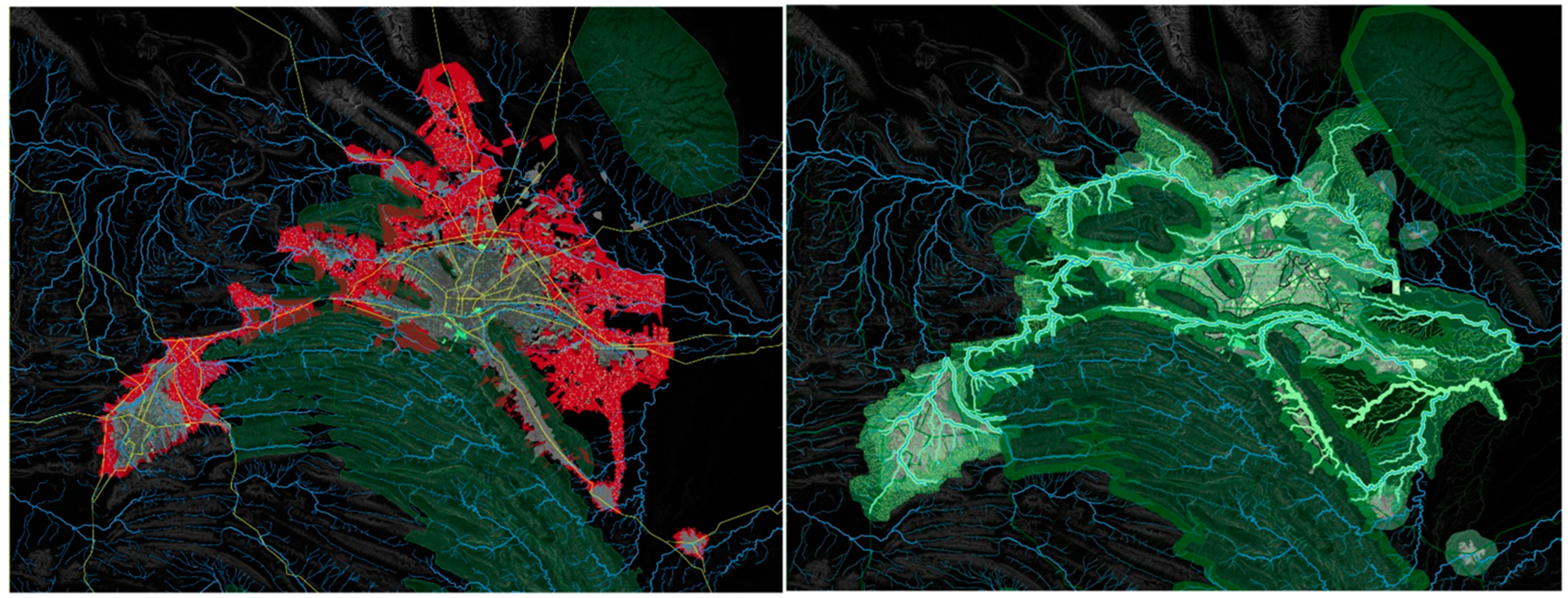
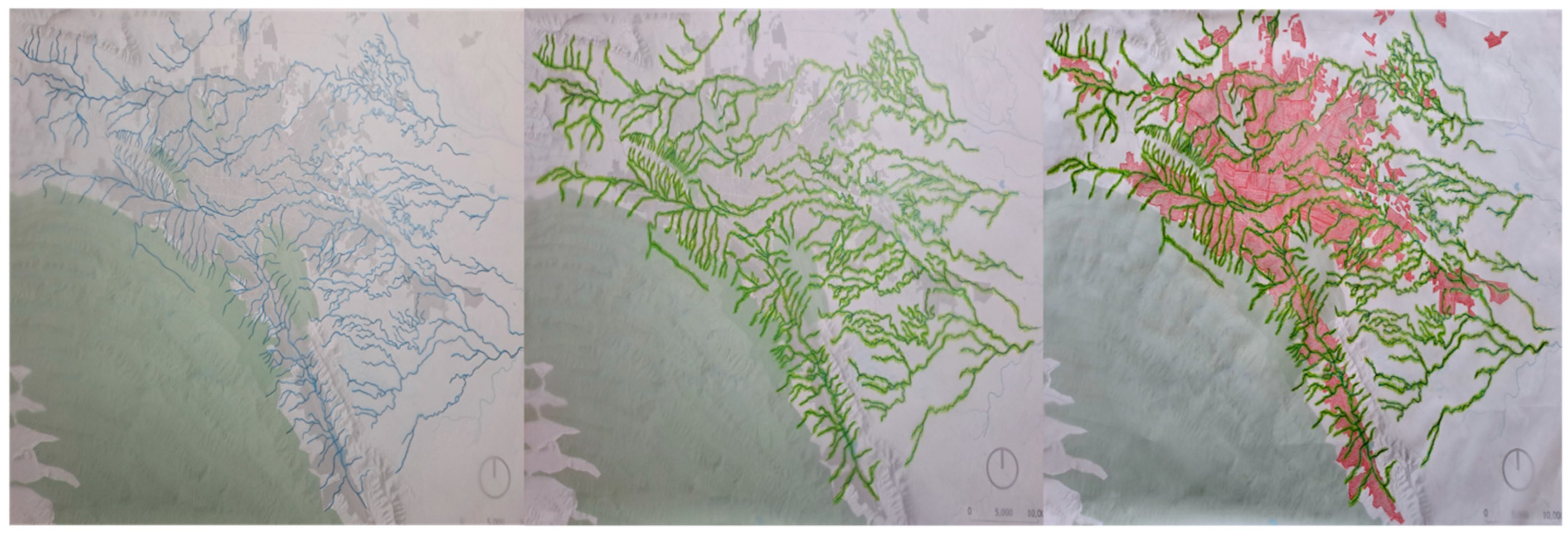
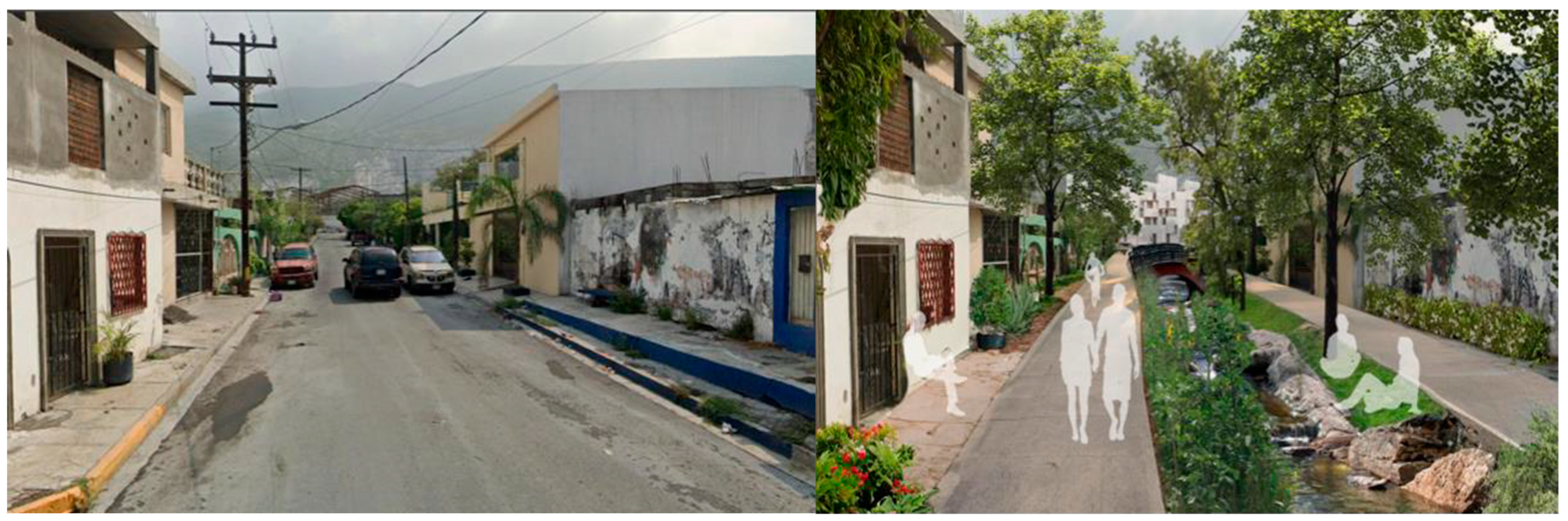
  • The hydro-ecological corridors (Figure 7) are revived as linear elements located where the original creeks flowed. The design principle aims to integrate nature into the city, re-naturalize watersheds [117], and reduce temperatures in the MMA. The transformation from an impermeable street without green and trees under which the waterway is hidden into a pleasant space for people to linger and enjoy it from their homes has not only environmental benefits but also invites people to go out and use the space and be close to nature.
2.
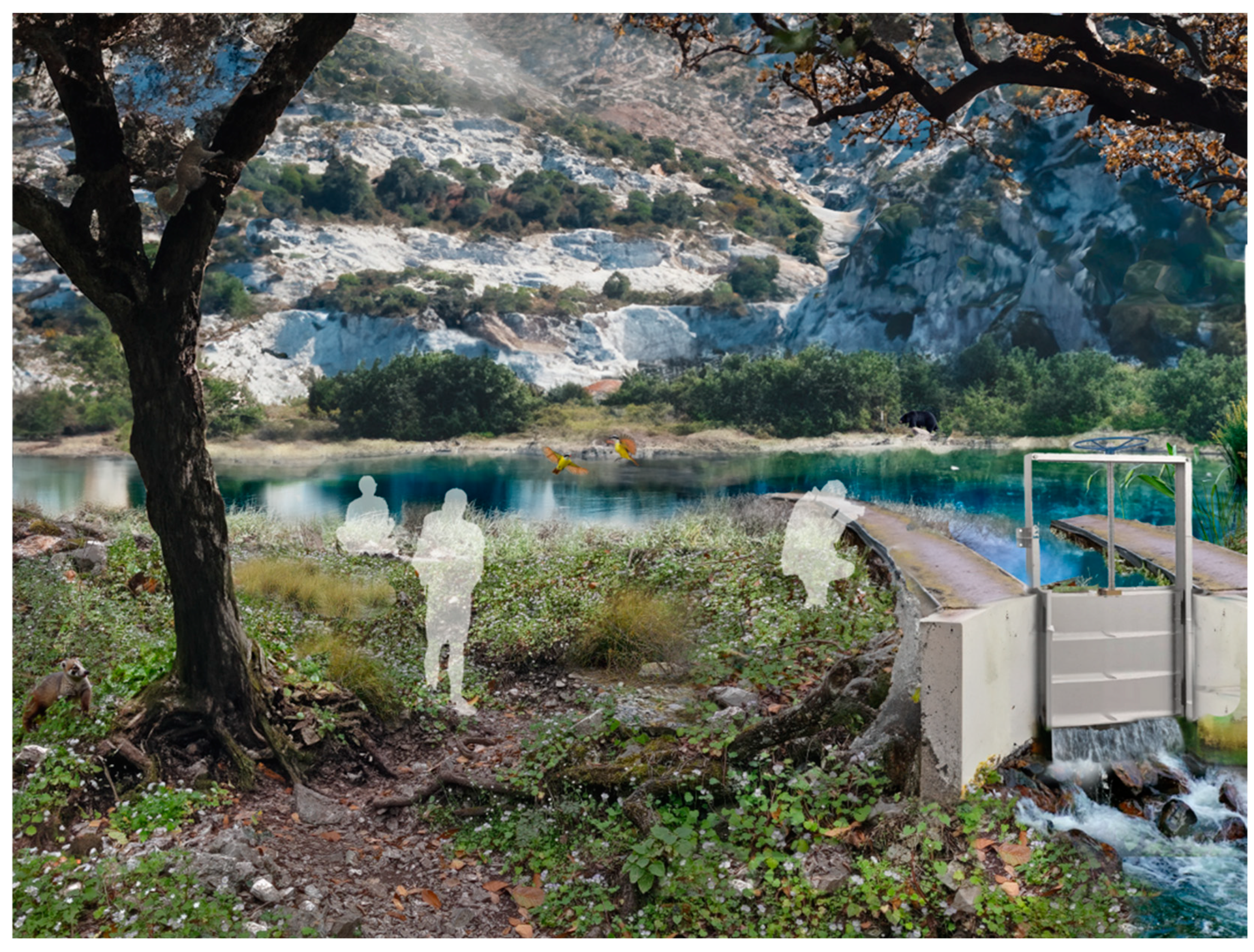
Water retention spaces (Figure 8) are located in areas where water runs off the mountain slopes, and there is a serious risk of flooding. The retention basins or ponds are designed to recharge the aquifer by infiltration and water absorption into the soil, and in the meantime, will reduce flood risk and improve the natural habitat. These spaces are crucial to slowing down runoff water, storing it, and releasing it slowly, but they also present an attractive small park to the people where they can experience nature, cooler temperatures, contemplate, and relax. It transforms an old quarry, currently a neglected space, into an area where people can relate to and spend time.
3.
Green islands have high permeability, contrary to concrete squares, roofs, or facades. This design principle aims to allow nature to reconquer these spaces and surfaces. This way, green areas emerge and are integrated into neighborhoods through small parks, green roofs, and vertical green facades. For example, people can use these novel green spaces as an urban food garden. These implementations allow people to become active and collaborate on planting and harvesting collectively grown crops. These practices improve social cohesion in the neighborhood, and people feel more attached to their direct environment [139,140]. As an additional benefit, these green spaces reduce the impervious surface, regulate the temperature, minimize urban heat, and capture excess rainwater.
4.
Greenways are spaces aligned with the road and rail network. Many of these left-over spaces are neglected and have become unsafe and unpleasant, turning into spatial barriers that are difficult to cross for pedestrians. By proposing to improve the spatial quality using green and natural vegetation and clear paths and routes, these spaces can become a place for people to rest and safely cross these infrastructures. They could even become spaces where the residents spend more time for play or recreation since they feel more at ease. In addition, these areas can regulate the local water system and can prevent droughts and floods, and biodiversity is enhanced.
The latter four design principles, such as using natural vegetation, tiny forests, recovery of waterways, and water retention ponds, are all basic elements that can be applied in similar conditions throughout the MMA. They provide attractive environments for the residents and create better living conditions for humans and non-humans.

5. Discussion

In this article, an approach to greening urban areas is proposed, which integrates emotions into the planning of urbanized regions. This approach connects how people experience their environment, their affection for nature and green, and the positive implications on their health with the physical spatial intervention executed in regular urban development processes. The attempt to plan greener cities is not new, and pledges for naturalizing the urban environment have been made globally [141,142]. In many cities, green structure plans, ecosystem policies, and water management plans have been directed toward this goal. Some focus on tree-planting programs [143], others develop a sponge city strategy [144] or focus on urban rewilding [145] or other forms of greening. Most of these programs emphasize the need to counteract economic-driven urban development with industrially and commercially planned precincts, which often do not pay much attention to lives, quality of life, and nature. In many ways, we might not have a good answer to an ever-progressing urbanization. These plans and strategies focus on specific topics, such as wild nature, water or parks, and green spaces, rather than holistic and integrated approaches. Moreover, plans are made for a specific scale, such as the municipal or neighborhood scale. The research presented in this article illustrates that it is helpful to connect the large scale with a hyperlocal project that manifests the more abstract green systems and structures, which connect the local, smaller projects. Finally, existing spatial planning policies are developed to solve the problems analyzed in the city through physical, spatial solutions. This article reveals that the understanding of emotion related to the experience in the urban environment can be used to identify different problems and develop coherent solutions that urban dwellers can embrace.
Some barriers to implementing this approach of connecting emotion to physical planning are related to the economic paradigm in many societies. It is still the case that the monetary gain stands in the way of thinking about developing a different approach, and this is complicated due to the segmented nature of actors involved in the urban development process. For example, if a construction company is involved, the aim is quickly directed to the financial gains, even if higher revenues would be possible by adopting an alternative, more holistic approach. These acts are partly caused by adherence to current working habits and ways of doing things. The planning processes have not fundamentally changed for a long time and are difficult to change. When the focus has always been on physical and spatial solutions to solve urban problems, the collaborative constellation will need significant incentives to act differently. Moreover, for people in working environments, it is easier to think in silos of the likeminded than having to face the trouble of delving into paradigms that are common in another silo or organization, even if their separated outcomes contradict or lead to suboptimal results for each of the silos. A final barrier is a general feeling amongst planners working in urban development to include ‘soft’ aspects, such as emotion, which troubles the planning process because it may lead to less clear or surprising planning outcomes, which are challenging to include in rational approaches to urban planning and decision-making. Related to this, the roles of different actors in implementing the strategies as pointed out in this article deserve specific attention. Local governments could include an emotional framework in the local planning regulations and spatial development strategies to start with by mapping out the different forms and appearances of landscape and other urban pain. Local communities could adopt the analysis and the spatial strategies of healing and loving as proposed transformations of their daily environment, for instance by creating spatial proposals as alternatives for projected plans and projects by private and public organizations. Finally, the private sector can realize improvements such as carbon offset, air quality improvements, water purification, and an increase in biodiversity on their premises, setting an example for future regenerative urban development. Each of these actors would benefit from experimenting, public education, co-created spatial policies, or novel pilot projects to learn, include, and embrace the integration of emotional aspects in spatial planning and urban development.
The theory presented in this article points to the valuable role of emotion in planning for green urban areas. It can be expected that a more robust and extensive network of eco-hydrological corridors, spaces, and networks is attractive to urban residents and will have considerable health benefits. This makes the approach applicable to many urban regions around the world. Pain, healing, and love can be identified for any climatic and cultural region, although it may show differently in every situation. The combination of visual, environmental, and functional pain and ways to solve and regain affection for the urban environment occur in every city and can be visualized and mapped. In a sequential study, this aspect deserves further attention, for instance by developing comparative studies across diverse cultural and climatic characteristics.
The mapping analysis highlights the landscape and hydrological pain as estimated for the Monterrey Metropolitan Area. It shows that emotions related to concrete spaces, infrastructures, and constructions can be used to identify physical urban problems, such as congestion, pollution, heat, etc., and correlate these to experienced negative emotions. However, validating the impact of healing and love strategies on the quality of urban life still has to be established.
Finally, the design for regeneration reveals that existing urban networks and public spaces can be redesigned to accommodate positive experiences. In the first instance, on a larger scale, a connected eco-hydrological network can heal significant parts of the pain. Second, the design principles turn spaces into attractive areas that people can learn to love. Emotions such as pain, healing, and love do not present a calculated, complex result. They can be interpreted by different people differently, but each of these interventions contributes in the long term to the enhancement of the natural qualities (air, water, soil, and ecology) of the regions and improves its overall resilience in dealing with disruptive changes, such as droughts, heat, and floods. Moreover, it provides the city with an urban identity that stands for taking care of its (human and non-human) citizens, minimizing its impact on other landscapes, countries, and organisms, and it appreciates the emotions of its inhabitants as a serious concern or pleasant happiness.

6. Conclusions

In carrying out this research, several limitations had to be acknowledged. The size of the Metropolis made it impossible to involve the residents of the metropolis in this regional and abstract study. This would require a substantial study which is recommended to be undertaken in following this study. Secondly, the proposed approach of including emotions in the planning for a regenerative metropolis is qualitative and must be seen as setting the agenda for more applications and more detailed analyses in the near future. Therefore, the time that was available for this research did not allow the team to fully collect data on how residents perceived pain in their city. Thirdly, the number of typical emotions. (pain, healing, and love), is, due to time constraints, also limited and could be expanded in future research to enrich the deepness of the analysis and establish a stronger connection to communities. Finally, the implementation of design principles is not part of this research project and shall be undertaken in co-creation with local communities, stakeholders, and residents. This is a recommendation for the different municipalities of the Monterrey Metropolis.
This research reveals that including emotion in urban planning is possible and beneficial. This aspect is underused but is a potential game-changer in how urbanites experience and develop affection for their green and healthy urban environment. However, at the same time, urban planners often see physical planning as a sound response to urban problems, even though these responses are frequently unsatisfactory and thematically isolated from each other. Therefore, physical planning is suboptimal and focuses solely on constructing or developing urban artifacts. Adding emotion to the planning for metropolises can redirect attention to a resilient, green, and nature-driven future. In this article, we have identified three core emotions that can be of use in planning a regenerative city, each with its own merits for specific urban activities, for a focus on the current situation or the future, in terms of whether it is used in an analytical or designedly process, and at which spatial scale problems and solutions are sought.
  • Pain is primarily focused on experienced problems, and mapping pain is an analytical process on a regional-to-local scale. It visualizes the current situation.
  • Healing is oriented towards the systemic strategies that can heal broken elements and landscapes in the metropolis; hence, it is working on a regional scale and focusing on the future.
  • Love aims to develop concrete future design solutions for the (hyper)local scale at the neighborhood and public space extents.
These emotions can be invaluable to spatial visions for urban areas because they can identify heartfelt problems, structurally repair degraded landscapes, and create valuable environments for the residents locally.
These actions require a staggered strategy, in which landscape pain is initially understood on the regional watershed scale, and healing opportunities are identified by designing spatial strategies that are based on the pristine natural landscape. The solutions require that natural systems be prioritized over human-made systems because current urban planning and design are too fragmented. The commercially driven urban development of individual projects on a plot-by-plot basis cannot halt urban sprawl and urbanization and faces difficulties reconnecting water and ecological systems throughout the metropolis.
Based on the outcomes of this research, it is recommended to analyze and map the landscape and hydrological pain at a regional scale. This is an alternative way to coherently understand urban problems, which require both physical and emotion-driven solutions. The intertwined relationship between the physical and emotional will support the development of a green metropolis because solutions for the urban problems are not only rationally underpinned by factual and physical measurements but are also supported by the population in the metropolis through their affection and positive impacts on their health. Therefore, it is recommended that a healing strategy be developed in response to the pain discovered. Once this systemic network is established, many local projects can be created that substantiate a larger network. The design principles developed in this research can function as a guide for multiplying these projects.
Many usual suspect stakeholders are focused on solving urgent problems and may not always be interested in the inclusion of emotional analyses or approaches. The key to this is to take the role of the resident seriously. Municipalities and private sector developers may explicitly develop the analysis of current pain and ways to heal, and create spaces that people will love, as part of their planning and development process from the first moment on. The residents can play a firm and rewarding role here, as they experience their emotions firsthand. When they are invited to map their emotions new pathways, plans and project outcomes can be expected that increase the environmental, visual, and monetary value of spaces, which is also beneficial for the developing party.
Furthermore, it is advised that spatial research be deepened to focus on integrating emotion into spatial planning. It is recommended that the research outcomes be used in several towns, cities, metropolises, and megalopolises in different climatic and social contexts to verify, refine, and apply the results of this study.

Author Contributions

Conceptualization, R.R.; methodology, R.R.; software, M.R.S.; validation, R.R., I.I.R.C. and R.J.L.; formal analysis, R.J.L., P.R.L., M.R.S. and M.O.D.; investigation, R.R., R.J.L., P.R.L., M.R.S. and M.O.D.; resources, R.R.; data curation, P.R.L., M.R.S. and M.O.D.; writing—original draft preparation, R.R.; writing—review and editing, I.I.R.C. and R.R.; visualization, R.J.L., P.R.L., M.R.S. and M.O.D.; supervision, R.R.; project administration, R.J.L.; funding acquisition, R.R. All authors have read and agreed to the published version of the manuscript.

Funding

This research was funded by the Fondo Ambiental Metropolitano de Monterrey (FAMM), 202402001.

Data Availability Statement

No new data were generated.

Acknowledgments

The authors cordially acknowledge the permanent support of Alfonso Garza Garza, Cesar Chavez, and Sergio Rodriguez for their suggestions and comments throughout the research project.

Conflicts of Interest

The authors declare no conflicts of interest.

References

  1. United Nations, Department of Economic and Social Affairs, Population Division. World Urbanization Prospects: The 2014 Revision, (ST/ESA/SER.A/366); United Nations, Department of Economic and Social Affairs, Population Division: New York, NY, USA, 2015. [Google Scholar]
  2. United Nations, Department of Economic and Social Affairs, Population Division. World Urbanization Prospects: The 2018 Revision (ST/ESA/SER.A/420); United Nations: New York, NY, USA, 2019. [Google Scholar]
  3. WHO. 2021 Urban Health. Available online: https://www.who.int/news-room/fact-sheets/detail/urban-health (accessed on 25 November 2024).
  4. UNEP. Cities and Climate Change. Available online: https://www.unep.org/explore-topics/resource-efficiency/what-we-do/cities-and-climate-change#:~:text=Rising%20global%20temperatures%20causes%20sea,housing%2C%20human%20livelihoods%20and%20health (accessed on 25 November 2024).
  5. IPCC. IPCC, 2022: Summary for Policymakers. In Climate Change 2022: Impacts, Adaptation, and Vulnerability; Contribution of Working Group II to the Sixth Assessment Report of the Intergovernmental Panel on Climate Change; Pörtner, H.-O., Roberts, D.C., Tignor, M., Poloczanska, E.S., Mintenbeck, K., Alegría, A., Craig, M., Langsdorf, S., Löschke, S., Möller, V., et al., Eds.; Cambridge University Press: Cambridge, UK; New York, NY, USA, 2022; pp. 3–33. [Google Scholar] [CrossRef]
  6. IEA. World Energy Outlook 2008; IEA: Paris, France, 2008; Available online: https://www.iea.org/reports/world-energy-outlook-2008 (accessed on 27 November 2024).
  7. Dhakal, S. Climate change and cities: The making of a climate friendly future. In Urban Energy Transition: From Fossil Fuel to Renewable Power; Droege, P., Ed.; Elsevier: Oxford, UK, 2008; pp. 173–182. [Google Scholar]
  8. Poumanyvong, P.; Kaneko, S. Does urbanization lead to less energy use and lower CO2 emissions? A cross-country analysis. Ecol. Econ. 2010, 70, 434–444. [Google Scholar] [CrossRef]
  9. O’Neill, B.C.; Dalton, M.; Fuchs, R.; Jiang, L.; Pachauri, S.; Zigova, K. Global demographic trends and future carbon emissions. Proc. Natl. Acad. Sci. USA 2010, 107, 17521–17526. [Google Scholar] [CrossRef]
  10. Jabbar, H.K.; Hamoodi, M.; Al-Hameedawi, A.N. Urban heat islands: A review of contributing factors, effects and data. IOP Conf. Ser. Earth Environ. Sci. 2023, 1129, 012038. [Google Scholar] [CrossRef]
  11. UNEP. Sustainable, Resource Efficient Cities—Making it Happen! UNEP: Nairobi, Kenya. Available online: https://sustainabledevelopment.un.org/content/documents/1124SustainableResourceEfficientCities.pdf (accessed on 25 November 2024).
  12. Molina, M.J.; Molina, L.T. Megacities and Atmospheric Pollution. J. Air Waste Manag. Assoc. 2004, 54, 644–680. [Google Scholar] [CrossRef]
  13. Siddiqua, A.; Hahladakis, J.N.; Al-Attiya, W.A.K. An overview of the environmental pollution and health effects associated with waste landfilling and open dumping. Environ. Sci. Pollut. Res. 2022, 29, 58514–58536. [Google Scholar] [CrossRef]
  14. Bakács, T. Public health problems in metropolitan areas. In Metropolitan Problems; Miles, S., Ed.; Routledge: London, UK, 2013; pp. 191–213. [Google Scholar]
  15. EPA. Climate Change and Social Vulnerability in the United States: A Focus on Six Impacts. U.S. Environmental Protection Agency, 2021. EPA 430-R-21-003. Available online: https://www.epa.gov/cira/social-vulnerability-report (accessed on 26 November 2024).
  16. Vernberg, W.B.; Scott, G.I.; Strozier, S.H.; Bemiss, J.; Daugomah, J.W. The Effects of Urbanization on Human and Ecosystem Health. In Sustainable Development in the Southeastern Coastal Zone; Vernberg, F.J., Vernberg, W.B., Siewicki, T.S., Eds.; University of South Carolina Press: Columbia, South Carolina, 1996; pp. 221–239. [Google Scholar]
  17. Zipperer Wayne, C.; Northrop, R.; Andreu, M. Urban Development and Environmental Degradation. Oxford Research Encyclopedia of Environmental Science. 2020. Available online: https://oxfordre.com/environmentalscience/view/10.1093/acrefore/9780199389414.001.0001/acrefore-9780199389414-e-97 (accessed on 1 September 2020).
  18. McGrane, S.J. Impacts of urbanisation on hydrological and water quality dynamics, and urban water management: A review. Hydrol. Sci. J. 2016, 61, 2295–2311. [Google Scholar] [CrossRef]
  19. UN Habitat Global State of Metropolis 2020. Population Data Booklet. UN Habitat: Nairobi, Kenia. 2020. Available online: https://unhabitat.org/sites/default/files/2020/09/gsm-population-data-booklet-2020_3.pdf (accessed on 6 October 2024).
  20. Oxford Dictionaries. Available online: https://web.archive.org/web/20160307093630/http://www.oxforddictionaries.com/definition/english/metropolis?q=Metropolis (accessed on 8 October 2024).
  21. Collins Dictionary. Available online: https://www.collinsdictionary.com/dictionary/english/metropolis (accessed on 8 October 2024).
  22. Owen, D. Green Metropolis: Why Living Smaller, Living Closer, and Driving Less Are the Keys to Sustainability; Riverhead Books: New York, NY, USA, 2009. [Google Scholar]
  23. Beatley, T. Green Metropolis. A new book argues that Manhattan is the greenest city in the United States. Places J. 2010. [Google Scholar] [CrossRef]
  24. Oliveira, E.A.; Andrade, J.S., Jr.; Makse, H.A. Large cities are less green. Sci. Rep. 2014, 4, 4235. [Google Scholar] [CrossRef] [PubMed]
  25. Han, Y.; He, J.; Liu, D.; Zhao, H.; Huang, J. Inequality in urban green provision: A comparative study of large cities throughout the world. Sustain. Cities Soc. 2023, 89, 104229. [Google Scholar] [CrossRef]
  26. Ripple, W.J.; Wolf, C.; Gregg, J.W.; Rockström, J.; Mann, M.E.; Oreskes, N.; Lenton, T.M.; Rahmstorf, S.; Newsome, T.M.; Xu, C.; et al. The 2024 state of the climate report: Perilous times on planet Earth. BioScience 2024, 74, biae087. [Google Scholar] [CrossRef]
  27. UN News Cities: A ’Cause of and Solution to’ Climate Change. Available online: https://news.un.org/en/story/2019/09/1046662 (accessed on 10 October 2024).
  28. Kowarik, I. Novel urban ecosystems, biodiversity, and conservation. Environ. Pollut. 2011, 159, 1974–1983. [Google Scholar] [CrossRef]
  29. Bahers, J.-B.; Rosado, L. The material footprints of cities and importance of resource use indicators for urban circular economy policies: A comparison of urban metabolisms of Nantes-Saint-Nazaire and Gothenburg. Clean. Prod. Lett. 2023, 4, 100029. [Google Scholar] [CrossRef]
  30. Papa, R.; Gargiulo, C.; Zucaro, F.; Angiello, G.; Carpentieri, G. Urban Energy Consumptions: Its Determinants and Future Research. WIT Trans. Ecol. Environ. 2014, 191, 561–570. [Google Scholar] [CrossRef]
  31. Ashley, J.; Zhou, B.; Barry, M. The impact of megacities on health: Preparing for a resilient future. Lancet Planet. Health 2017, 1, e176–e178. [Google Scholar]
  32. Cerón Breton, R.M.; Céron Breton, J.; De la Luz Espinosa Fuentes, M.; Kahl, J.; Espinosa Guzman, A.A.; Martínez, R.G.; Guarnaccia, C.; del Carmen Lara Severino, R.; Ramirez Lara, E.; Francavilla, A.B. Short-term associations between morbidity and air pollution in metropolitan area of Monterrey, Mexico. Atmosphere 2021, 12, 1352. [Google Scholar] [CrossRef]
  33. Frank, L.D.; Engelke, P.O. The built environment and human activity patterns: Exploring the impacts of urban form on public health. J. Plan. Lit. 2001, 16, 202–218. [Google Scholar] [CrossRef]
  34. Lopez, R.P.; Hynes, H.P. Obesity, physical activity, and the urban environment: Public health research needs. Environ. Health 2006, 5, 1–10. [Google Scholar] [CrossRef]
  35. Krefis, A.C.; Augustin, M.; Schlünzen, K.H.; Oßenbrügge, J.; Augustin, J. How does the urban environment affect health and well-being? A systematic review. Urban Sci. 2018, 2, 21. [Google Scholar] [CrossRef]
  36. Rose, N. Mental health, stress and the contemporary metropolis. In Urban Transformations and Public Health in the Emergent City; Keith, M., De Souza Santos, A.A., Eds.; Manchester University Press: Manchester, UK, 2020; pp. 35–54. [Google Scholar]
  37. Iungman, T.; Cirach, M.; Marando, F.; Pereira-Barboza, E.; Khomenko, S.; Masselot, P.; Quijal-Zamorano, M.; Mueller, N.; Gasparrini, A.; Urquiza, J.; et al. Cooling cities through urban green infrastructure: A health impact assessment of European cities. Lancet 2023, 401, 577–589. [Google Scholar] [CrossRef]
  38. Bathiany, S.; Dakos, V.; Scheffer, M.; Lenton, T.M. Climate models predict increasing temperature variability in poor countries. Sci. Adv. 2018, 4, eaar5809. [Google Scholar] [CrossRef] [PubMed]
  39. Ashinze, U.K.; Edeigba, B.A.; Umoh, A.A.; Biu, P.W.; Daraojimba, A.I. Urban green infrastructure and its role in sustainable cities: A comprehensive review. World J. Adv. Res. Rev. 2024, 21, 928–936. [Google Scholar] [CrossRef]
  40. Hanna, E.; Comín, F.A. Urban Green Infrastructure and Sustainable Development: A Review. Sustainability 2021, 13, 11498. [Google Scholar] [CrossRef]
  41. Ahern, J. Green infrastructure for cities: The spatial dimension. In Cities of the Future Towards Integrated Sustainable Water and Landscape Management; Novotny, V., Brown, P., Eds.; IWA Publishing: London, UK, 2007. [Google Scholar]
  42. Russo, A.; Cirella, G.T. Urban sustainability: Integrating ecology in city design and planning. In Sustainable Human–Nature Relations: Environmental Scholarship, Economic Evaluation, Urban Strategies; Springer: Singapore, 2020; pp. 187–204. [Google Scholar]
  43. Van Zyl, B.; Cilliers, E.J.; Lategan, L.G.; Cilliers, S.S. Closing the gap between urban planning and urban ecology: A South African perspective. Urban Plan. 2021, 6, 122–134. [Google Scholar] [CrossRef]
  44. Verma, P.; Singh, R.; Singh, P.; Raghubanshi, A.S. Urban ecology–current state of research and concepts. In Urban Ecology; Verma, P., Singh, R., Singh, P., Raghubanshi, A.S., Eds.; Elsevier: Amsterdam, The Netherlands, 2020; pp. 3–16. [Google Scholar] [CrossRef]
  45. Roggema, R. Adaptation to Climate Change: A Spatial Challenge; Springer: Dordrecht, The Netherlands, 2009. [Google Scholar]
  46. Araos, M.; Berrang-Ford, L.; Ford, J.D.; Austin, S.E.; Biesbroek, R.; Lesnikowski, A. Climate change adaptation planning in large cities: A systematic global assessment. Environ. Sci. Policy 2016, 66, 375–382. [Google Scholar] [CrossRef]
  47. Pasini, R. The Symbiotic Field. Landscape Paradigms and Post-Urban Spaces; The Urban Book Series; Springer: Cham, Switzerland, 2017. [Google Scholar]
  48. Alsayed, S.S. Urban human needs: Conceptual framework to promoting urban city fulfills human desires. Front. Sustain. Cities 2024, 6, 1395980. [Google Scholar] [CrossRef]
  49. Krupat, E. People in Cities. The Urban Environment and its Effects; Cambridge University Press: Cambridge, CA, USA, 1985. [Google Scholar]
  50. Burns, A. Emotion and Urban Experience: Implications for Design. Des. Issues 2000, 16, 67–79. Available online: https://www.jstor.org/stable/1511816 (accessed on 21 October 2024). [CrossRef]
  51. Lively, K.J.; Heise, D.R. Sociological realms of emotional experience. Am. J. Sociol. 2004, 109, 1109–1136. [Google Scholar] [CrossRef]
  52. Thoits, P.A. The sociology of emotions. Annu. Rev. Sociol. 1989, 15, 317–342. [Google Scholar] [CrossRef]
  53. Barrett, L.F.; Mesquita, B.; Ochsner, K.N.; Gross, J.J. The experience of emotion. Annu. Rev. Psychol. 2007, 58, 373–403. [Google Scholar] [CrossRef]
  54. Seamon, D. Emotional experience of the environment. Am. Behav. Sci. 1984, 27, 757–770. [Google Scholar] [CrossRef]
  55. Beatty, A. Anthropology and emotion. J. R. Anthropol. Inst. 2014, 20, 545–563. [Google Scholar] [CrossRef]
  56. Knudsen, B.T. Emotional Geography. Ethnologia Europaea 2006, 36, 5–15. [Google Scholar]
  57. Thagard, P. Emotional cognition in urban planning. In Complexity, Cognition, Urban Planning and Design; Portugali, J., Stolk, E., Eds.; Springer: Berlin, Germany, 2016; pp. 197–213. [Google Scholar]
  58. Foley, R. Affective landscapes: Capturing emotions in place. In The Routledge Handbook of Methodologies in Human Geography; Routledge: Milton Park, UK, 2022; pp. 109–122. [Google Scholar]
  59. Vaz de Camoes, L. (1524–1589) Amor Um Fogo Que Arde Sem se Ver. Available online: https://allpoetry.com/Amor--um-fogo-que-arde-sem-se-ver#tr_8492145 (accessed on 30 November 2024).
  60. Davidson, J.; Milligan, C. Embodying Emotion Sensing Space: Introducing Emotional Geographies. Soc. Cult. Geogr. 2004, 5, 523–532. [Google Scholar] [CrossRef]
  61. Simmel, G. The Metropolis and the Mental Life. In On Individuality and Social Forms; Levine, D., Ed.; The University of Chicago Press: Chicago, IL, USA, 1971; pp. 143–149. [Google Scholar]
  62. Futrell, R. The Expendable City: Las Vegas and the Limits of Sustainability. Humboldt J. Soc. Relat. 2001, 26, 81–112. [Google Scholar]
  63. Lofland, L.H. The Public Realm: Exploring the City’s Quintessential Social Territory; Aldine de Gruytrer: New York, NY, USA, 1988. [Google Scholar]
  64. Borer, M.I. Being in the City: The Sociology of Urban Experiences. Sociol. Compass 2013, 7, 965–983. [Google Scholar] [CrossRef]
  65. COMPAC Luis Barragán, A Style Marked by Emotion. Available online: https://www.thedecorativesurfaces.com/en/luis-barragan/ (accessed on 30 November 2024).
  66. Cheshmehzangi, A. Identity of Cities and City of Identities; Springer: Singapore, 2020. [Google Scholar] [CrossRef]
  67. Lynch, K. The Image of the City; The MIT Press: Cambridge, CA, USA; London, UK, 1960. [Google Scholar]
  68. Alexander, C.; Ishikawa, S.; Silverstein, M.; Jacobson, M.; Fiksdahl-King, I.; Angel, S. A Pattern Language. Towns, Buildings, Construction; Oxford University Press: Oxford, UK, 1977. [Google Scholar]
  69. Kaymaz, I. Urban landscapes and identity. In Advances in Landscape Architecture; Özyavuz, M., Ed.; IntechOpen: London, UK, 2013. [Google Scholar] [CrossRef]
  70. Palmiero, M.; Piccardi, L. The Role of Emotional Landmarks on Topographical Memory. Front. Psychol. Sect. Cogn. 2017, 8, 763. [Google Scholar] [CrossRef]
  71. Samavati, S.; Veenhoven, R. Happiness in urban environments: What we know and don’t know yet. J. Hous. Built Environ. 2024, 39, 1649–1707. [Google Scholar] [CrossRef]
  72. Joye, Y.; Van den Berg, A. Is love for green in our genes? A critical analysis of evolutionary assumptions in restorative environments research. Urban For. Urban Green. 2011, 10, 261–268. [Google Scholar] [CrossRef]
  73. Wilson, E.O. Biophilia: The Human Bond with Other Species; Harvard University Press: Cambridge, CA, USA, 1984. [Google Scholar]
  74. Steg, L.; Van den Berg, A.E.; De Groot, J.I.M. (Eds.) Environmental Psychology: An Introduction; Blackwell: Oxford, UK, 2012. [Google Scholar]
  75. Hartig, T.; Evans, G.W.; Jamner, L.D.; Davis, D.S.; Gärling, T. Tracking restoration in natural and urban field settings. J. Environ. Psychol. 2003, 23, 109–123. [Google Scholar] [CrossRef]
  76. Kaplan, R.; Kaplan, S. The Experience of Nature: A Psychological Perspective; Cambridge University Press: New York, NY, USA, 1989. [Google Scholar]
  77. Ulrich, R.S.; Simons, R.F.; Losito, B.D.; Fiorito, E. Stress recovery during exposure to natural and urban environments. J. Environ. Psychol. 1991, 11, 201–230. [Google Scholar] [CrossRef]
  78. Kaplan, S. Meditation, restoration, and the management of mental fatigue. Environ. Behav. 2001, 33, 480–506. [Google Scholar] [CrossRef]
  79. Ulrich, R.S. View through a window may influence recovery from surgery. Science 1984, 224, 224–225. [Google Scholar] [CrossRef] [PubMed]
  80. Wilkinson, C.; Macfarlane, A.H.; Hikuroa, D.C.H.; McConchie, C.; Payne, M.; Holmes, H.; Mohi, R.; Hughes, M.W. Landscape change as a platform for environmental and social healing. Kōtuitui N. Z. J. Soc. Sci. Online 2022, 17, 352–377. [Google Scholar] [CrossRef]
  81. Rubio Cisneros, I.I. Geología y Estado. Forma, Fondo y Territorios Vecinos de México; UANL: Monterrey, Mexico, 2018; 402p. [Google Scholar]
  82. Rubio Cisneros, I.I. Uncomfortable environmental issues: Advised cases for medical geology in Monterrey, México. In Proceedings of the 10th International Conference on Medical Geology, Monterrey, Mexico, 6–9 August 2023; p. 89. [Google Scholar]
  83. Crutzen, P.J.; Stoermer, E.F. The “Anthropocene”. Glob. Chang. Newsl. 2000, 41, 17–18. [Google Scholar]
  84. Crutzen, P.J. Geology of mankind. Nature 2002, 415, 23. [Google Scholar] [CrossRef] [PubMed]
  85. Albrecht, G. Ecopsychology in the symbio-cene. Ecopsychology 2014, 6, 58–59. [Google Scholar] [CrossRef]
  86. Albrecht, G. Exiting the Anthropocene and Entering the Symbiocene. 2015. Available online: https://glennaalbrecht.wordpress.com/2015/12/17/exiting-the-anthropocene-and-entering-the-symbiocene/ (accessed on 14 April 2024).
  87. Albrecht, G.A. Negating solastalgia: An emotional revolution from the Anthropocene to the Symbiocene. Am. Imago 2020, 77, 9–30. [Google Scholar] [CrossRef]
  88. Albrecht, G.A. Earth Emotions: New Words for a New World; Cornell University Press: Ithaka, NY, USA, 2019. [Google Scholar]
  89. Albrecht, G.; Sartore, G.M.; Connor, L.; Higginbotham, N.; Freeman, S.; Kelly, B.; Stain, H.; Tonna, A.; Pollard, G. Solastalgia: The distress caused by environmental change. Australasian Psychiatry 2007, 15 (Suppl. 1), S95–S98. [Google Scholar] [CrossRef] [PubMed]
  90. SEDATU; CONAPO; INEGI. Metrópolis de Mexico 2020; Gobierno de México: México City, Mexico, 2024. Available online: https://www.gob.mx/cms/uploads/sedatu/MM2020_06022024.pdf (accessed on 13 October 2024).
  91. Lehner, B.; Verdin, K.; Jarvis, A. New global hydrography derived from spaceborne elevation data. Eos Trans. Am. Geophys. Union 2008, 89, 93–94. [Google Scholar] [CrossRef]
  92. INEGI (Instituto Nacional de Estadística y Geografía). Simulador de Flujos de Agua de Cuencas Hidrográficas (SIATL). 2020. Available online: https://antares.inegi.org.mx/analisis/red_hidro/siatl/# (accessed on 15 March 2024).
  93. Secretaría de Medio Ambiente de Nuevo León. Listado de Árboles y Plantas Nativas del Estado de Nuevo León [PDF]. 2023. Available online: https://historico.nl.gob.mx/publicaciones/listado-de-arboles-y-plantas-nativas-del-estado-de-nuevo-leon (accessed on 6 October 2024).
  94. INEGI. Registro Vehicular en los 18 Municipios del Área Metropolitana de Monterrey; Instituto Nacional de Estadística y Geografía: Mexico City, Mexico, 2023. [Google Scholar]
  95. Instituto Nacional d’Estadística i Institut d’Estadística de Catalunya. 2022. Available online: https://www.idescat.cat/emex/?id=080193&lang=es (accessed on 6 October 2024).
  96. GHS Settlement Characteristics. 2018. Available online: https://developers.google.com/earth-engine/datasets/catalog/JRC_GHSL_P2023A_GHS_BUILT_C (accessed on 7 October 2024).
  97. CONEVAL Índice de Rezago Social 2020 a Nivel Nacional, Estatal, Municipal y Localidad. 2020. Available online: https://www.coneval.org.mx/Medicion/IRS/Paginas/Indice_Rezago_Social_2020.aspx (accessed on 20 October 2024).
  98. CONAGUA Informe de Precipitaciones y Eventos Hidrometeorológicos en México. 2021. Comisión Nacional del Agua. Available online: https://smn.conagua.gob.mx/es/climatologia/pronostico-climatico/precipitacion-form (accessed on 12 July 2024).
  99. Carpio, A.; Ponce-Lopez, R.; Lozano-García, D.F. Urban form, land use, and cover change and their impact on carbon emissions in the Monterrey Metropolitan area, Mexico. Urban Clim. 2021, 39, 100947. [Google Scholar] [CrossRef]
  100. Copernicus Agencia Aspacial Europea. Mapa de la Isla de Calor Urbano (UHI). Copernicus Open Access Hub. 2024. Available online: https://browser.dataspace.copernicus.eu (accessed on 7 October 2024).
  101. Global Land Analysis & Discovery. Global Forest Loss due to Fire. 2022. Available online: https://glad.earthengine.app/view/global-forest-loss-due-to-fire (accessed on 8 October 2024).
  102. Observatorio de la Calidad del Aire. Datos históricos sobre la calidad del aire en el Área Metropolitana de Monterrey; Instituto Nacional de Ecología y Cambio Climático: México City, Mexico, 2024. [Google Scholar]
  103. BCStats. 2023. Available online: https://www2.gov.bc.ca/assets/gov/data/statistics/people-population-community/population/pop_bc_annual_estimates.csv (accessed on 6 March 2024).
  104. INEGI. Censo Poblacional. 2020. Available online: www.inegi.org.mx/programas/ccpv/2020/#resultados_generales (accessed on 20 March 2024).
  105. Servicio Meteorológico Nacional. Información Meteorológica y Climatológica. Comisión Nacional del Agua. 2023. Available online: https://smn.conagua.gob.mx/es/ (accessed on 12 September 2024).
  106. Sirko, W.; Kashubin, S.; Ritter, M.; Annkah, A.; Bouchareb, Y.S.E.; Dauphin, Y.; Keysers, D.; Neumann, M.; Cisse, M.; Quinn, J.A. Continental-scale building detection from high resolution satellite imagery. arXiv 2021, arXiv:2107.12283. [Google Scholar]
  107. Open Buildings Dataset (Google Earth Engine). Available online: https://sites.research.google/gr/open-buildings/#open-buildings-download (accessed on 8 October 2024).
  108. Debbage, N.; Marshall Shepherd, J. The urban heat island effect and city contiguity. Comput. Environ. Urban Syst. 2015, 54, 181–194. [Google Scholar] [CrossRef]
  109. Balon, N.; Hrdalo, I.; Mrđa, A.; Kamenečki, M.; Tomić Reljić, D.; Pereković, P. Landscape urbanism—Retrospective on development, basic principles and application. Architecture 2023, 3, 739–752. [Google Scholar] [CrossRef]
  110. Cao, Q.; Liu, Y.; Georgescu, M.; Wu, J. Impacts of landscape changes on local and regional climate: A systematic review. Landsc. Ecol. 2020, 35, 1269–1290. [Google Scholar] [CrossRef]
  111. WHO. Health Indicators of Sustainable Cities in the Context of the Rio+20 UN Conference on Sustainable Development; WHO: Geneva, Switzerland, 2012. [Google Scholar]
  112. Konijnendijk, C.C. Evidence-based guidelines for greener, healthier, more resilient neighborhoods: Introducing the 3–30–300 rule. J. For. Res. 2023, 34, 821–830. [Google Scholar] [CrossRef]
  113. WHO. Urban Green Spaces: A Brief for Action; World Health Organization, Regional Office for Europe: Bonn, Germany, 2017; Available online: https://www.who.int/europe/publications/i/item/9789289052498 (accessed on 20 October 2024).
  114. Zhou, W.; Wang, J.; Cadenasso, M.L. Effects of the spatial configuration of trees on urban heat mitigation: A comparative study. Remote Sens. Environ. 2017, 195, 1–12. [Google Scholar] [CrossRef]
  115. Litman, T. Transportation and public health. Annu. Rev. Public Health 2013, 34, 217–233. [Google Scholar] [CrossRef] [PubMed]
  116. Shoub, D. The High Cost of Free Parking; Planner Press: Chicago, IL, USA, 2011. [Google Scholar]
  117. Wolch, J.R.; Byrne, J.; Newell, J.P. Urban green space, public health, and environmental justice: The challenge of making cities ’just green enough’. Landsc. Urban Plan. 2014, 125, 234–244. [Google Scholar] [CrossRef]
  118. Rizwan, A.M.; Dennis, L.Y.C.; Liu, C. A review on the generation, determination and mitigation of urban heat island. J. Environ. Sci. 2008, 20, 120–128. [Google Scholar] [CrossRef] [PubMed]
  119. Santamouris, M. Analyzing the heat island magnitude and characteristics in one hundred Asian and Australian cities and regions. Sci. Total Environ. 2015, 512–513, 582–598. [Google Scholar] [CrossRef] [PubMed]
  120. CDC (Center for Disease Control and Prevention). What Noises Cause Hearing Loss? 2020. Available online: www.cdc.gov/nceh/hearing_loss/what_noises_cause_hearing_loss.html (accessed on 20 October 2024).
  121. Kheifets, L.; Swanson, J. Electric and magnetic fields and cancer: The epidemiological evidence. Environ. Res. 2020, 186, 109565. [Google Scholar] [CrossRef]
  122. Ellis, J.B. The Management and Control of Urban Runoff Quality. Water Environ. J. 1989, 3, 116–124. [Google Scholar] [CrossRef]
  123. Ramirez, R.; Selsky, J.W.; Van der Heijden, K. Business Planning for Turbulent Times: New Methods for Applying Scenarios; Routledge: Abingdon, UK, 2010. [Google Scholar]
  124. Roggema, R.; Dassen, T. Thinking in Improbabilities. In Trends in Urban Design: Insights for the Future Urban Professional; Roggema, R., Ed.; Springer: Dordrecht, The Netherlands, 2023; pp. 69–79. [Google Scholar]
  125. Van der Heijden, K. Scenarios: The Art of Strategic Conversation; John Wiley & Sons: Hoboken, NJ, USA, 2005. [Google Scholar]
  126. Wright, G.; Van der Heijden, K.; Burt, G.; Bradfield, R.; Cairns, G. Scenario planning interventions in organizations: An analysis of the causes of success and failure. Futures 2008, 40, 218–236. [Google Scholar] [CrossRef]
  127. Bishop, P.; Martinez Perez, A.; Roggema, R.; Williams, L. (Eds.) Repurposing the Green Belt in the 21st Century; UCL Press: London, UK, 2020; 168p. [Google Scholar] [CrossRef]
  128. Roggema, R. From Your Balcony to the World: An Ecocathedric Approach to Regenerating Urban Landscapes; Keynote Forum on Urban Innovation and Sustainability: San Pedro Garza Garcia, Mexico, 2024. [Google Scholar]
  129. Roggema, R. (Ed.) Nature-Driven Urbanism; Springer: Dordrecht, The Netherlands, 2020. [Google Scholar]
  130. Roggema, R. From Nature-based to Nature-driven: Landscape first for the design of Moeder Zernike. Sustainability 2021, 13, 2368. [Google Scholar] [CrossRef]
  131. Roggema, R.; Monti, S. Nature driven planning for the FEW-Nexus in Western Sydney. In TransFEWmation. Towards Design-Led Food-Energy-Water Systems for Future Urbanization; Roggema, R., Ed.; Springer: Dordrecht, The Netherlands, 2021; pp. 59–94. [Google Scholar]
  132. Roggema, R.; Keeffe, G.; Tillie, N. Nature-based urbanization: Scan opportunities, determine directions and create inspiring ecologies. Land 2021, 10, 651. [Google Scholar] [CrossRef]
  133. Roggema, R.; Tillie, N.; Hollanders, M. Designing the adaptive landscape: Leapfrogging stacked vulnerabilities. Land 2021, 10, 158. [Google Scholar] [CrossRef]
  134. Nijhuis, S. Landscape-Based Urbanism: Cultivating Urban Landscapes Through Design. In Design for Regenerative Cities and Landscapes: Rebalancing Human Impact and Natural Environment; Roggema, R., Ed.; Springer: Dordrecht, The Netherlands, 2022; pp. 249–277. [Google Scholar]
  135. Nijhuis, S.; Xiong, L.; Cannatella, D. Towards a Landscape-based Regional Design Approach for Adaptive Transformation in Urbanizing Deltas. Res. Urban. Ser. 2022, 6, 55–80. [Google Scholar]
  136. Cortés-Melo, G. La Planificación de una Metrópoli: Por un Urbanismo Integral, Humanista y Sustentable, Tomo I; UANL: Monterrey, Mexico, 2014; 272p. [Google Scholar]
  137. Rubio Cisneros, I.I. Preliminary cartographic diagnosis for environmental and geological compensations in the municipality of Guadalupe, Nuevo León. Ing. Investig. Tecnol. 2023, XXIV, 1–8. [Google Scholar] [CrossRef]
  138. Van der Wel, P. Hydrate Monterrey: A Spatial Strategy to Implement Green and Blue Infrastructure in Order to Tackle Droughts and Heat Stress in Monterrey, Mexico. Master’s Thesis, Architecture and the Built Environment, Delft University of Technology, Delft, The Netherlands, 2024. [Google Scholar]
  139. Petit-Boix, A.; Apul, D. From cascade to bottom-up ecosystem services model: How does social cohesion emerge from urban agriculture? Sustainability 2018, 10, 998. [Google Scholar] [CrossRef]
  140. Stefani, M.C.; Orsini, F.; Magrefi, F.; Sanyé-Mengual, E.; Pennisi, G.; Michelon, N.; Bazzocchi, G.; Gianquinto, G. Toward the Creation of Urban Foodscapes: Case Studies of Successful Urban Agriculture Projects for Income Generation, Food Security, and Social Cohesion. In Urban Horticulture. Sustainable Development and Biodiversity; Nandwani, D., Ed.; Springer: Cham, Switzerland, 2018; Volume 18. [Google Scholar] [CrossRef]
  141. UN Habitat. Greener Cities Partnership (UN-Habitat and UN Environment. 2016. Available online: https://unhabitat.org/greener-cities-partnership (accessed on 21 October 2024).
  142. WEF. Nature Positive: Guidelines for the Transition in Cities, Insight Report. In collaboration with Oliver Wyman. 2024. Available online: https://www3.weforum.org/docs/WEF_Nature_Positive_Guidelines_for_the_Transition_in_Cities_2024.pdf (accessed on 21 October 2024).
  143. Trees of the World. Available online: https://treecitiesoftheworld.org (accessed on 22 October 2024).
  144. Yu, K. The sponge city: Planning, Design and Political Design. In Architecture and the Climate Emergency—Everything Needs to Change; Pelsmakers, S., Newman, N., Eds.; RIBA Publishing: London, UK, 2021; pp. 47–55. [Google Scholar]
  145. C40 Cities and ARUP. Urban Rewilding. The Value and co-Benefits of Nature in Urban Spaces. 2023. Available online: https://c40.my.salesforce.com/sfc/p/#36000001Enhz/a/Hp000000haJF/GiSUGhj3_IYcI_fm4n08xW8Vap411v2vVsjom_rGzCw (accessed on 21 October 2024).
Figure 1. Monterrey Metropolitan Area (source: Google Earth).
Land 14 00164 g001
Figure 2. Overview of the steps and parts of the research.
Land 14 00164 g002
Figure 3. Map with integrated aspects of landscape pain (by the authors).
Land 14 00164 g003
Figure 4. Map of hydrological pain (by the authors).
Land 14 00164 g004
Figure 5. Strategy to uncover creeks and waterways, green the regional network, and find spaces for urbanity within (by the authors).
Land 14 00164 g005
Figure 6. Sequential regional planning strategy: uncovering the creeks and waterways, greening the regional network, and finding spaces for urbanity within [128].
Land 14 00164 g006
Figure 7. Transforming a street into a hydro-ecological corridor [138].
Land 14 00164 g007
Figure 8. Water retention design principle [138].
Land 14 00164 g008
Table 1. Maps of current conditions and sources used [91,92,93,94,95,96,97,98,99,100,101,102,103,104,105].
MapData Source
Rio Bravo basinLehner et al., 2008 [91]
Monterrey’s subbasinsINEGI 2020 [92]
EcoregionsSecretaría de Medio Ambiente de Nuevo León 2023 [93]
Land coverNALCMS
Green cover, city comparisonINEGI (2023) [94], BC Stats (2023) [103], Instituto Nacional d’Estadística I Institut d’Estadística de Catalunya (2022) [95], GHS Settlement Characteristics (2018) [96].
Percentage natural areaNALCMS 2020, GHSL 2018 [96]
Proximity to green spaces and accessibility by vulnerable groupsLANDSAT 2019, Population and Housing Census [104], INEGI, 2020 [104], Open Street Maps, CONEVAL 2020 [97]
Heat indexURSA, BID
RainfallCONAGUA [98], Servicio Meteorológico Nacional, 2023 [105]
Urban growthSecretaria de Desarrollo Sustentable de Nuevo León, Carpio et al., 2021 [99], GHSL and Consejo Nuevo León
Urban densitySecretaría de Desarrollo Sustentable de Nuevo León (2018), Carpio et al. (2021) [99], GHSL and Consejo Nuevo León (2023).
Urban heat islands and wildfiresCopernicus Agencia Espacial Europea (2024) [100]; Global land analysis and discovery (2022) [101]
Air qualityThe Observatory of Air Quality in Metropolitan Monterrey OCCAMM 2024 [102]
* Bold is the main flow of the research, the others are sectors.
Table 2. Identification of pain, healing, and love based on Earth emotions’ vocabulary (after [88]).
Verb Translation Etymology Explanation
PAIN
TerraphthoraEarth-destroyerterra = earth; phthora = to destroy, destroy, ruinEarth destroyers will be increasingly held accountable, both by the public and politicians.
TierratraumaEarth traumatierra = region/zone; trauma = woundAn ‘acute Earth-based existential trauma in the present’.
SolastalgiaConsolationsolari = to comfort; nostalgia = longing for past timesA ‘pain or distress caused by the loss -or lack of- solace and the sense of desolation connected to the present state of one’s home and territory’.
TerrafuriaClimate rageterra = earth; furia = anger, rage‘The extreme anger unleashed within those who can see the self-destructive tendencies in the current forms of industrial-technological society and feel they must protest and act to change its direction’.
HEAL
SumbiofactBuilt-with-naturesumbio = from the close cooperation between two or more different biological entities; factum = operation, creation, result of action/deedFabricated by human/nature interaction. As distinct from ‘artifact’, an object made artificially by a human being.
Symbiocene symbiosis = living together; kainos = newThe Symbiocene will be in evidence when there is no discernible impact of human activity on the planet other than the temporary remains of their teeth and bones. Everything that humans do will be integrated within the support systems of all life and will leave no trace’.
LOVE
EndomophiliaOwn-place-loveendemos = native, at home, born and raised in, among us; philia = love for‘The particular love of that which is locally and regionally distinctive as felt by the people of that place’.
EutierriaPlanet connectioneu = good; terra = earth; tierra = region/zone‘A positive and good feeling of oneness with the Earth and its life forces where the boundaries between self and the rest of nature are obliterated and a deep sense of peace and connectedness pervades consciousness’.
PsychoterraticEarth soul movementspsyche = the human soul or spirit; terratic = relating to the earth‘Emotions related to (positively and negatively) perceived and felt states of the Earth’.
TerranasciaSoil enricherterra = earth; nascia = to be born‘Green Gold’, ’Earth creator’
* The bold/color gives the major distinction of categories.
Table 3. Mapping landscape pain and the sources used [106,107,108,109,110].
MapData Sources
Quarries and constructions in natural reservesNPA, Open buildings dataset (Google Earth Engine), Sirko et al., 2021 [106]
Large roads (more than six lanes each way)INEGI [104]
XL and L buildingsOpen buildings dataset (Google Earth Engine, https://sites.research.google/gr/open-buildings/#open-buildings-download, Accessed on 9 October 2024) [107]. Sirko et al., 2021 [106]
Heat islandsDebbage and Marshall Shepherd, 2015 [108]
Railways and above metro systemINEGI, PRIMUS 2019 [92]
Energy infrastructure/air qualitySecretaria de Desarrollo Sustentable de Nuevo Leon, 2018.
Hydrological obstructionsINEGI 2020 [92], Open buildings dataset [107]
Landscape transformationBalon et al., 2023 [109]; Cao et al., 2020 [110]
Disclaimer/Publisher’s Note: The statements, opinions and data contained in all publications are solely those of the individual author(s) and contributor(s) and not of MDPI and/or the editor(s). MDPI and/or the editor(s) disclaim responsibility for any injury to people or property resulting from any ideas, methods, instructions or products referred to in the content.

