

Machine-Learning-Algorithm-Based Prediction of Land Use/Land Cover and Land Surface Temperature Changes to Characterize the Surface Urban Heat Island Phenomena over Harbin, China


Abstract
1. Introduction
- (1)
- Investigate changes in LULC and seasonal LST in Harbin City, China, from 2005 to 2020 (at 5-year intervals) using Landsat series satellite images. Use the Bi-LSTM model to predict future LST based on the existing data and verify its accuracy.
- (2)
- Predict LULC and LST in 2025 and 2030 using the PLUS and Bi-LSTM models and analyze changes in LULC and LST from 2005 to 2030.
- (3)
- Estimate the UTFVI using LST and analyze the spatiotemporal distribution of UTFVI in Harbin from 2005 to 2030 and the changes in UTFVI for different LULC types.
2. Study Area and Methods
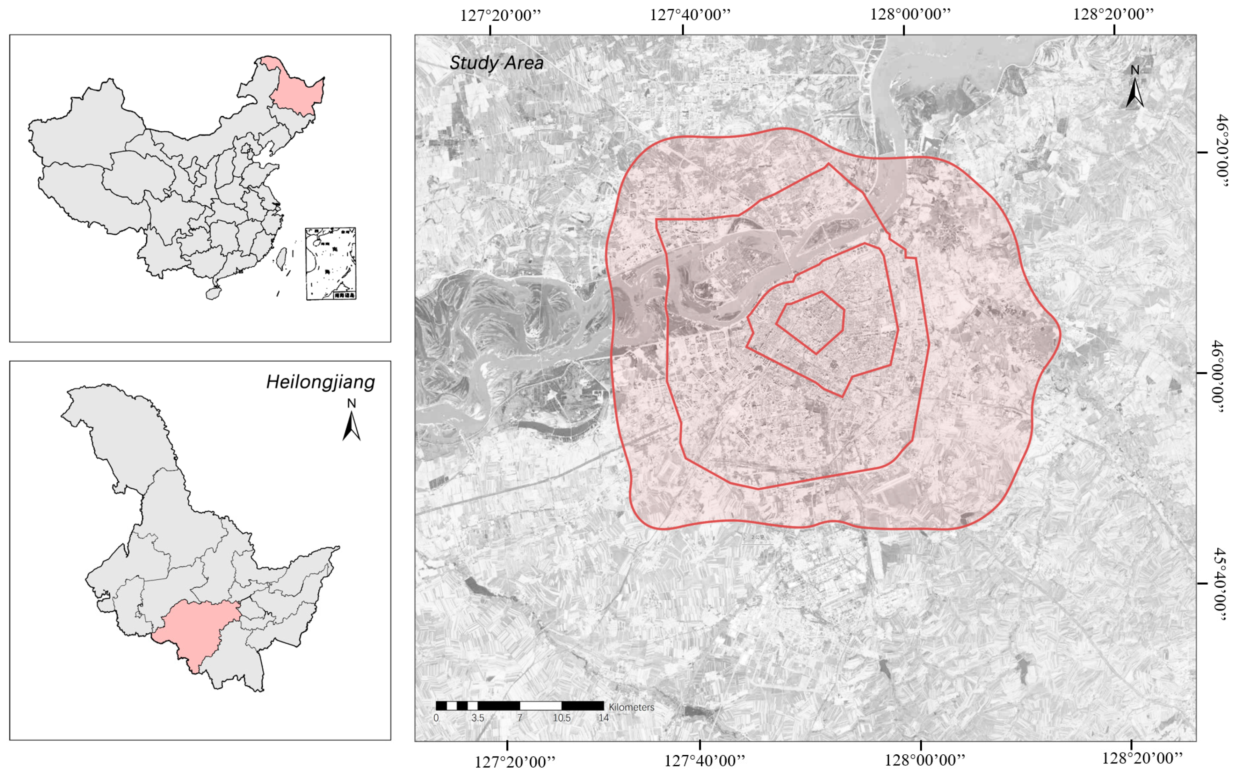
2.1. Study Area and Climatic Contexts
2.2. Data Sources
2.3. LULC Classification
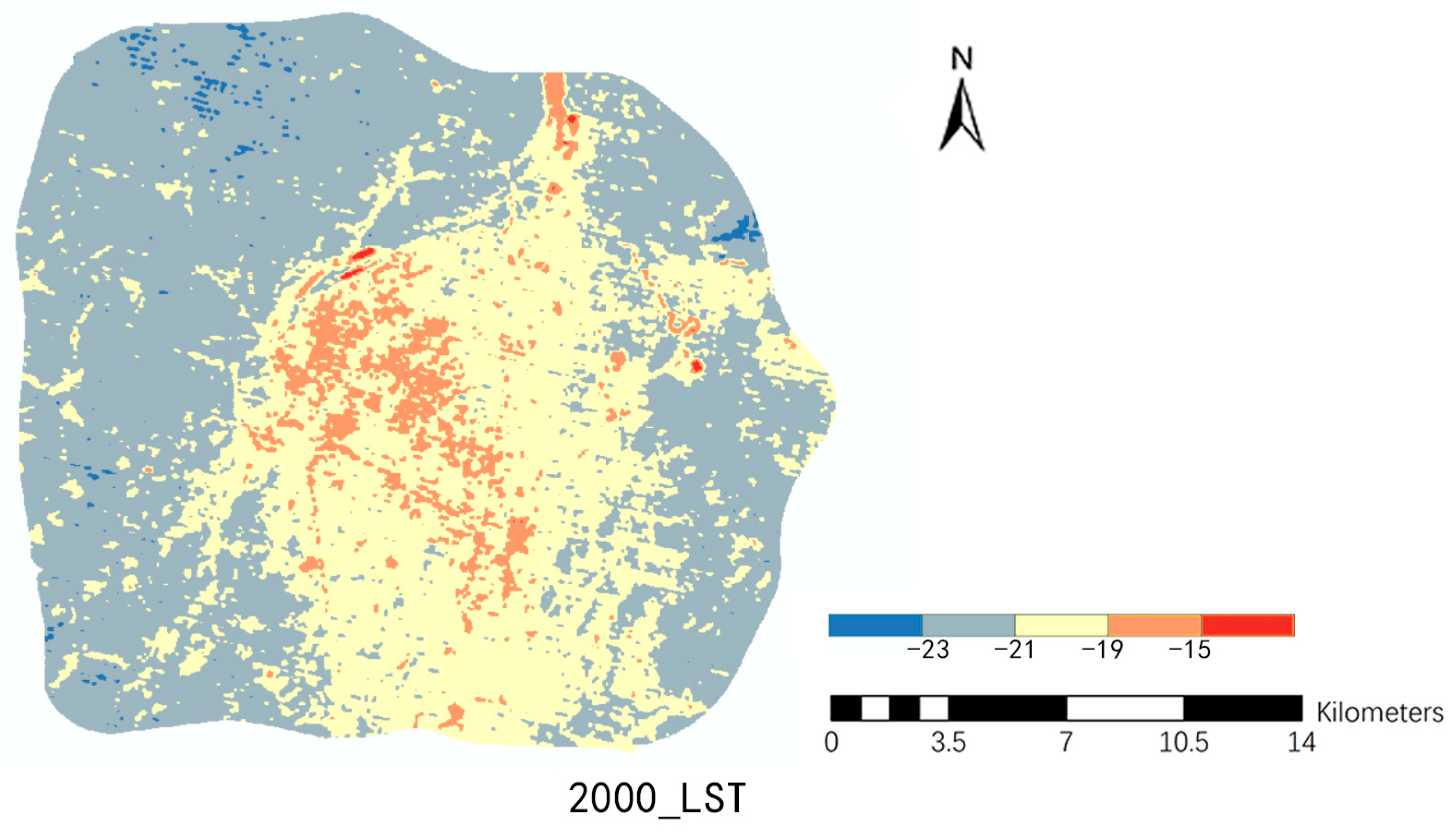
2.4. LST Inversion
2.5. Estimation of UTFVI
2.6. PLUS Model
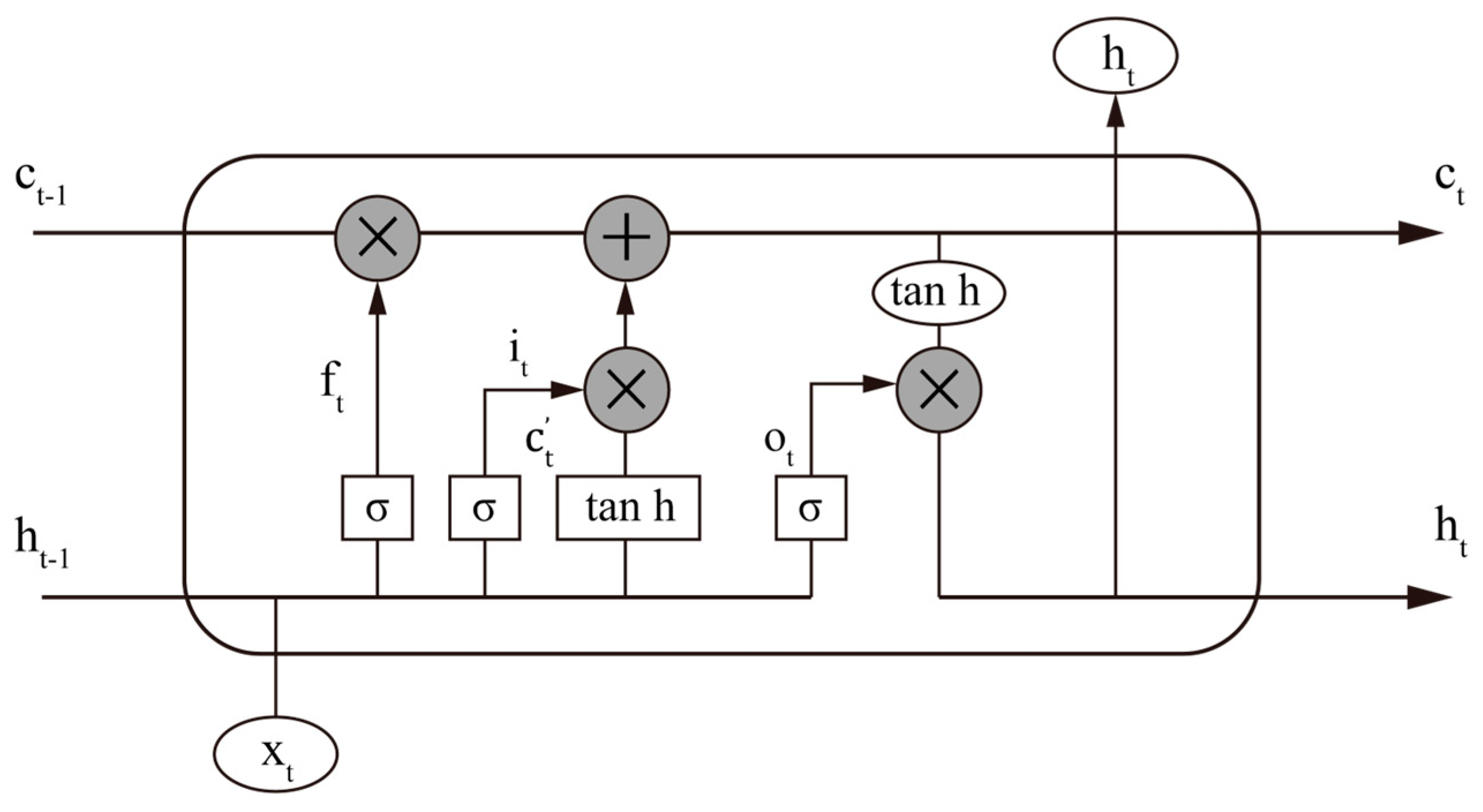
2.7. Bi-LSTM Model
3. Results
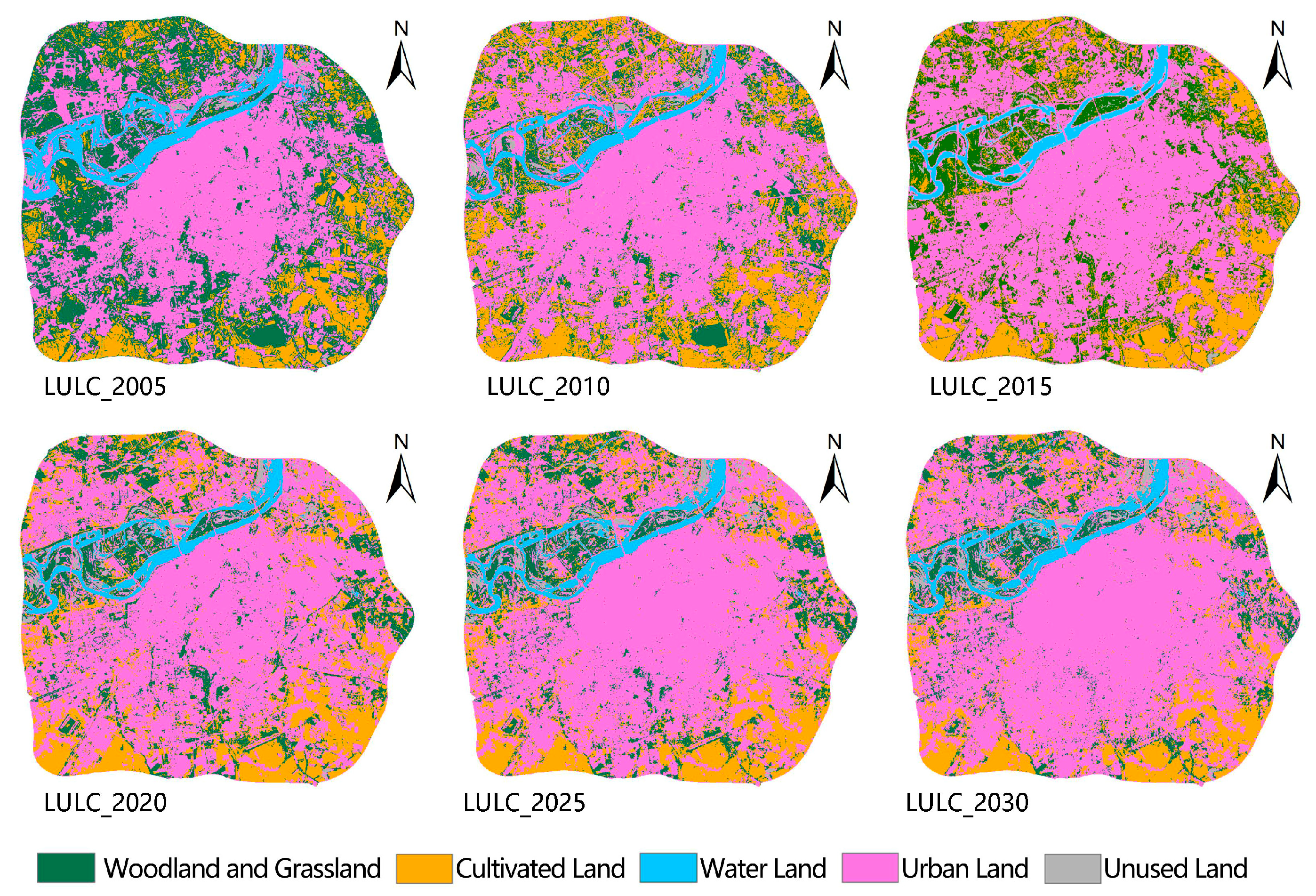
3.1. LULC Prediction and Trend Analysis
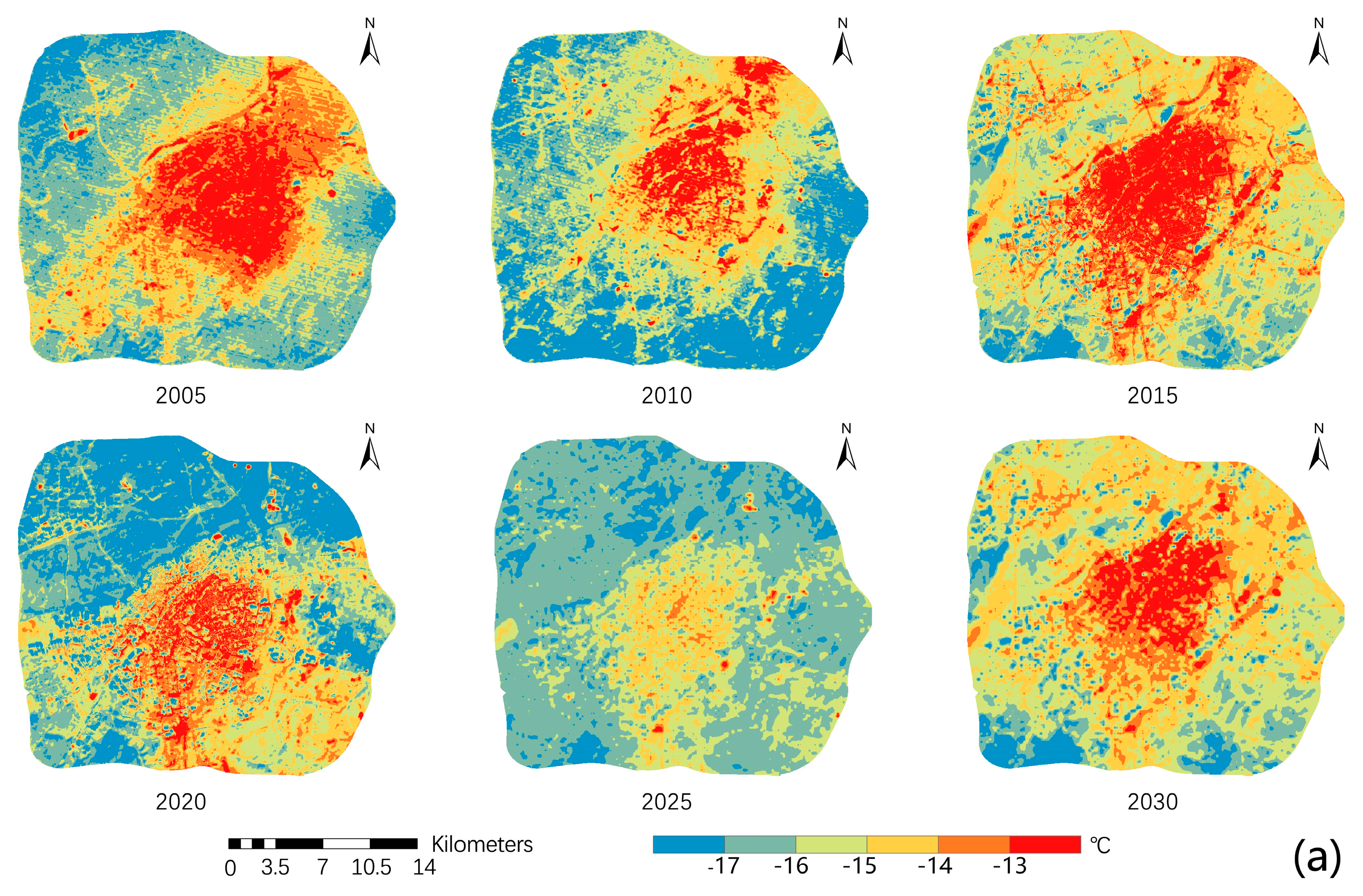
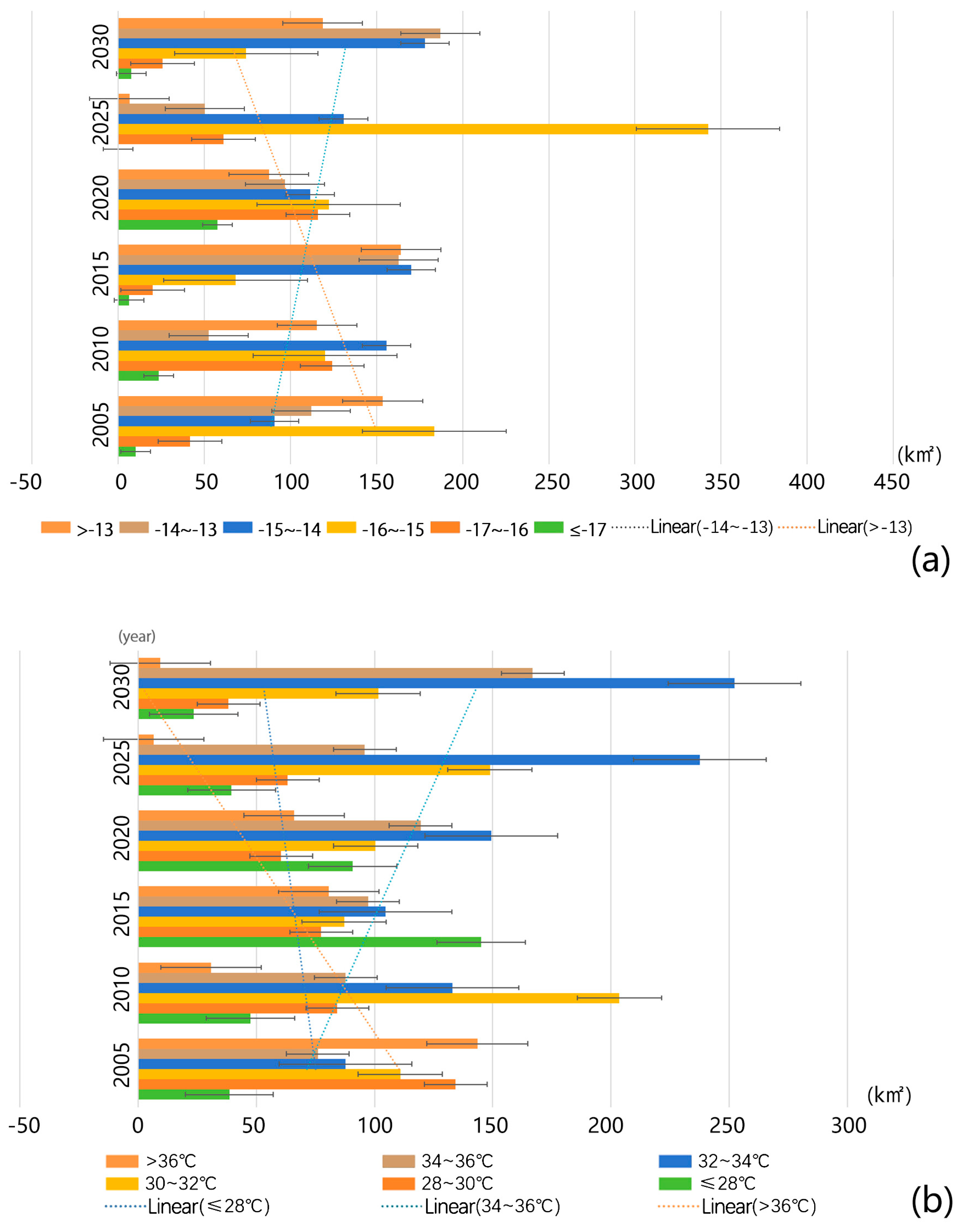
3.2. LST Prediction and Trend Analysis
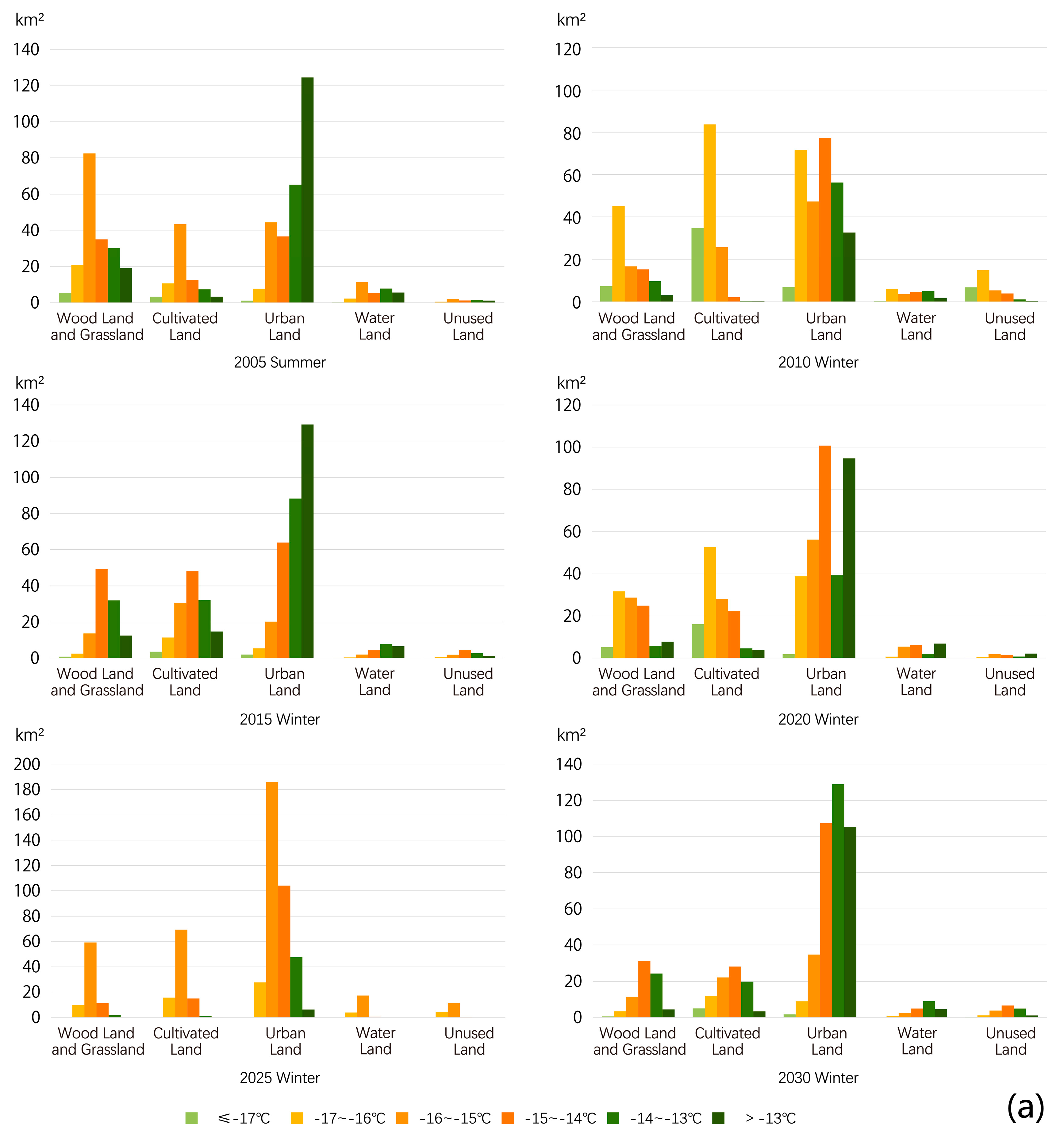
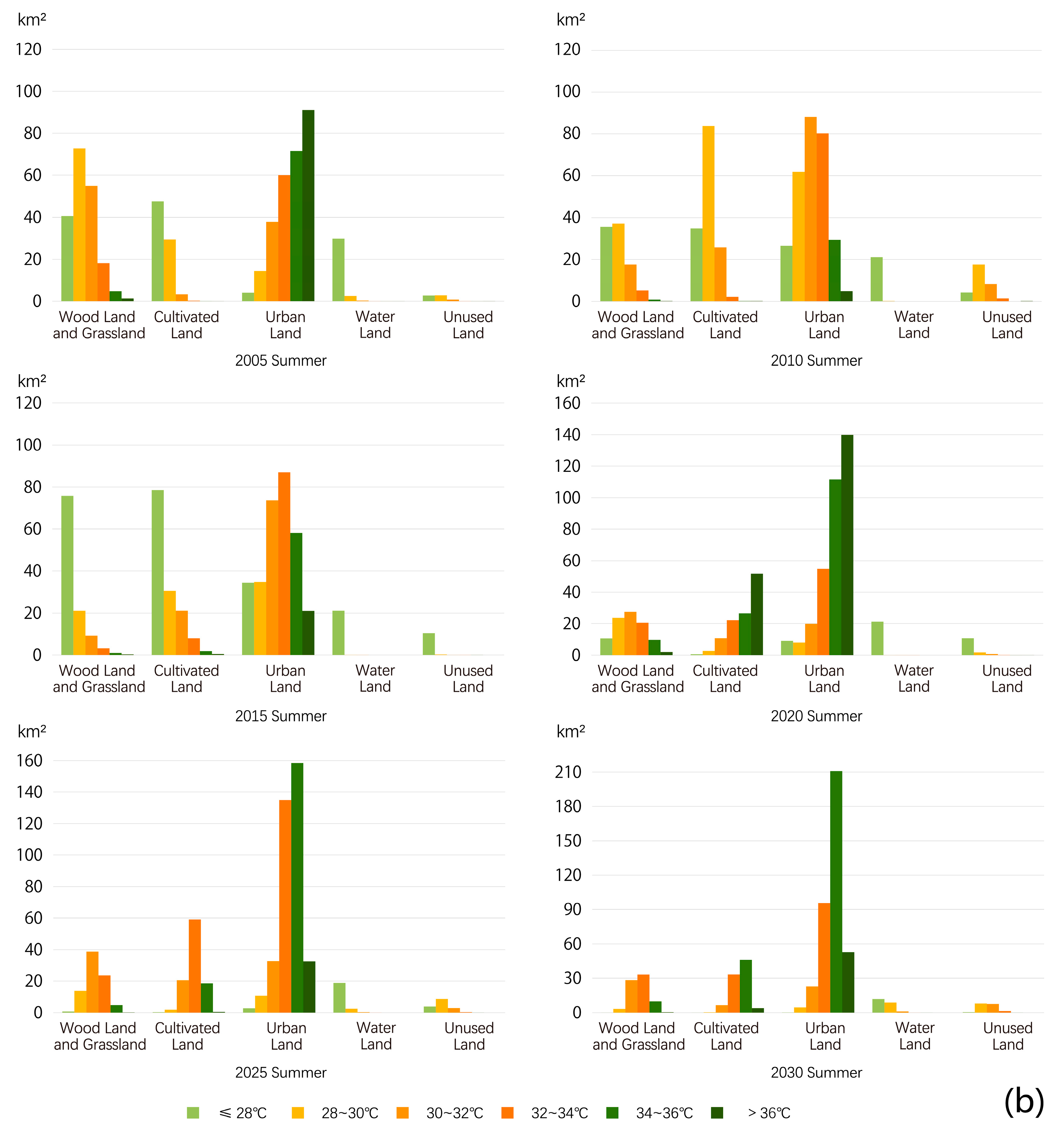
3.3. LST Distribution under Different LULC Classes
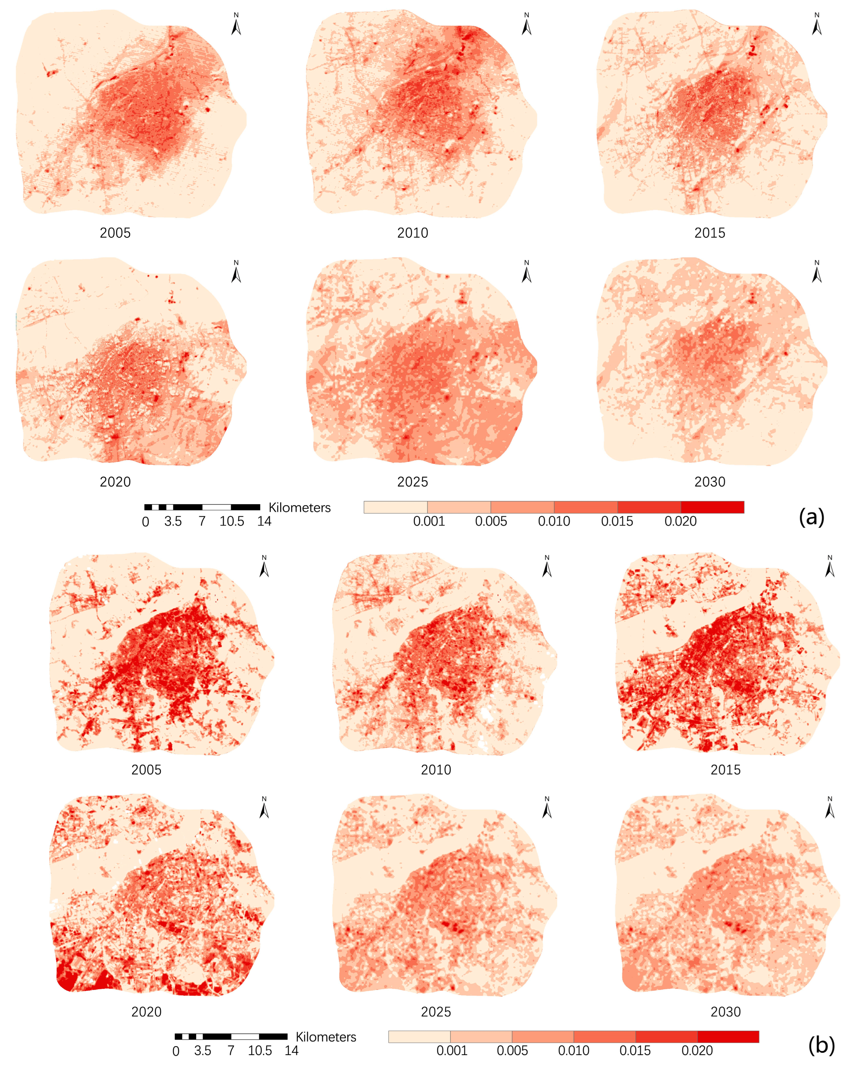
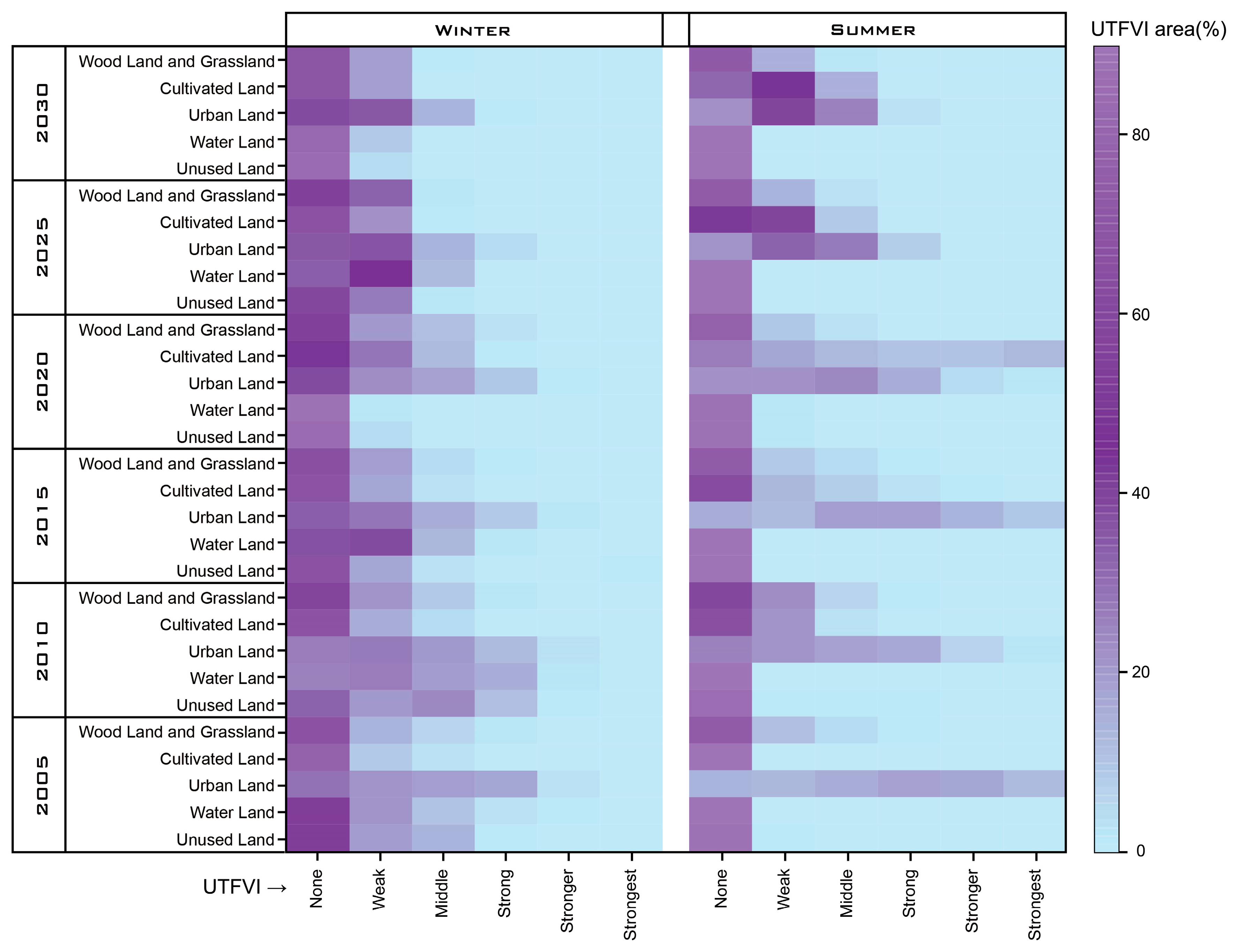
3.4. Variation Analysis of Seasonal UTFVI
3.5. UTFVI Variation over Different LULC Classes
4. Discussion
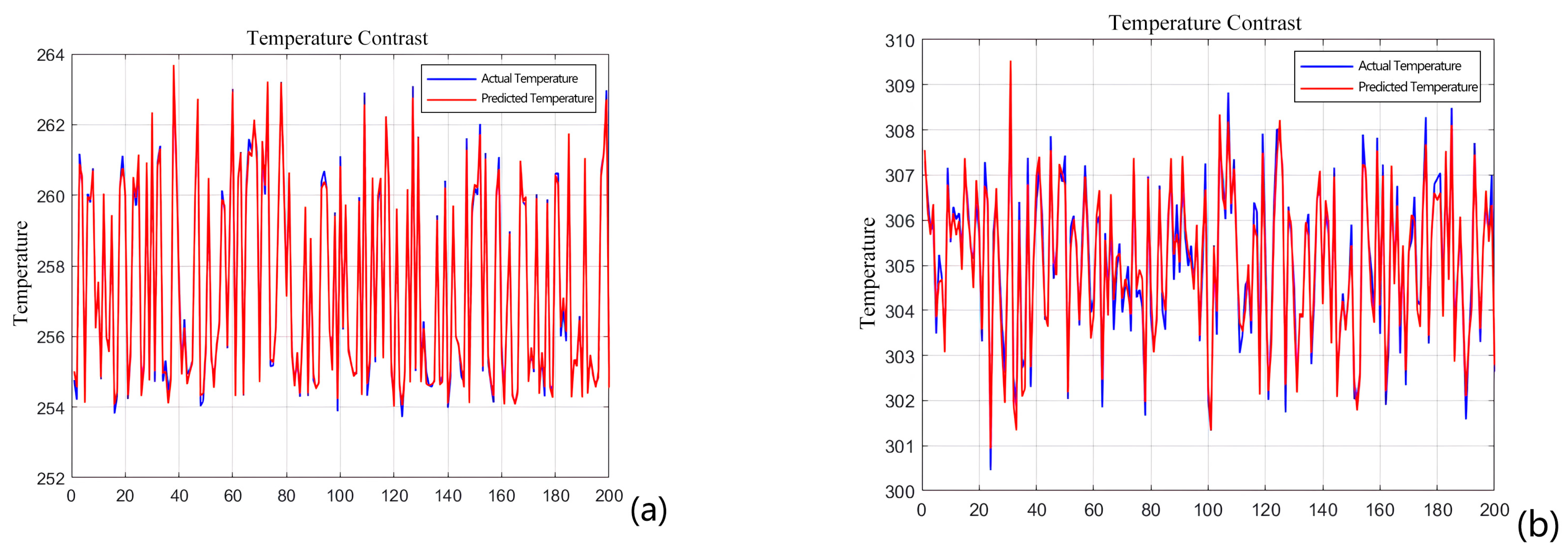
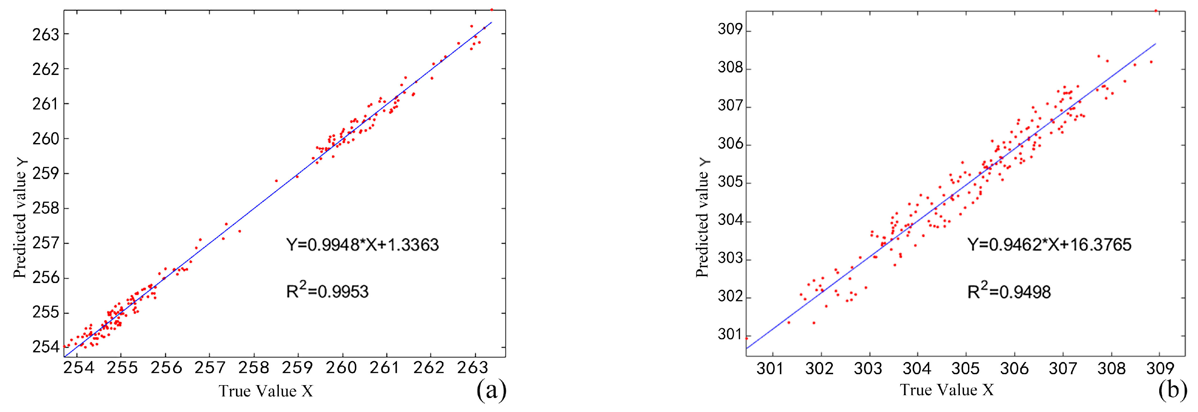
4.1. Validation of the Accuracy of the Bi-LSTM Model
4.2. Strategies to Mitigate UHI in the Central City Area
5. Conclusions
- This study established a Bi-LSTM model to predict seasonal LSTs. The and RMSE values were 0.9953 and 0.1990 in winter and 0.9498 and 0.3901 in summer, indicating high prediction accuracies and outperforming the other models.
- The area of urban land increased from 2005 to 2030, with a growth rate of 27.81%. The area of woodland and grassland decreased at a rate of 61.07%, and the area of water land and unused land remained stable, indicating that the urban land will continue to expand gradually in the future.
- The surface temperature inversion results and the Bi-LSTM model prediction results show a decrease in the area of the extreme temperature zone in winter and summer and an increase in the area of the highest temperature zone from 2005 to 2030. The area of the highest temperature zone (LST > −13 °C) in winter had a decrease rate of 61.01%, and the growth rate of the area of the high-temperature zone (−14.9 °C to −13 °C) was 40.86%. The rates of decrease in the areas of the highest (LST > 36 °C) and lowest (LST ≤ 28 °C) temperature zones in summer were 93.47% and 39.06%, and the growth rate of the area with the high-temperature zone (32 °C–36 °C) was 60.9%. The area with the lowest LST (≤−16 °C) was transformed into an area with high LSTs (−14.9 °C–−13 °C). Urban land with high temperatures (LST > 34 °C) expanded with a growth rate of 62.06%. LULC change due to urban development and expansion led to increases in LSTs.
- UTFVI zones above high values (>0.010) decreased from 2005 to 2030, with a reduction rate of 90.73%. Zones with high UTFVI values were located in urban land, and this effect was more pronounced in summer. The proportion of areas with medium UTFVI values zones (0.005–0.010) in urban land increased at a rate of 50.71%. In contrast, the proportion of areas with medium UTFVI values and above (>0.005) decreased at a rate of 84.70%. This result shows that the area affected by the UHI has decreased, the UHI intensity in some regions has increased, and the quality of the urban thermal environment has worsened.
Author Contributions
Funding
Data Availability Statement
Conflicts of Interest
References
- Hassan, T.; Zhang, J.; Prodhan, F.A.; Sharma, T.P.P.; Bashir, B. Surface urban heat islands dynamics in response to LULC and vegetation across South Asia (2000–2019). Remote Sens. 2021, 13, 3177. [Google Scholar] [CrossRef]
- Al Kafy, A.; Rahman, S.; Faisal, A.-A.; Hasan, M.M.; Islam, M. Modelling future land use land cover changes and their impacts on land surface temperatures in Rajshahi, Bangladesh. Remote Sens. Appl. Soc. Environ. 2020, 18, 100314. [Google Scholar]
- Mohammad, P.; Goswami, A. Predicting the impacts of urban development on seasonal urban thermal environment in Guwahati city, northeast India. Build. Environ. 2022, 226, 109724. [Google Scholar] [CrossRef]
- Goldblatt, R.; Addas, A.; Crull, D.; Maghrabi, A.; Levin, G.G.; Rubinyi, S. Remotely sensed derived land surface temperature (LST) as a proxy for air temperature and thermal comfort at a small geographical scale. Land 2021, 10, 410. [Google Scholar] [CrossRef]
- Al Kafy, A.; Faisal, A.A.; Rahman, S.; Islam, M.; Al Rakib, A.; Islam, A.; Khan, H.H.; Sikdar, S.; Sarker, H.S.; Mawa, J.; et al. Prediction of seasonal urban thermal field variance index using machine learning algorithms in Cumilla, Bangladesh. Sustain. Cities Soc. 2021, 64, 102542. [Google Scholar] [CrossRef]
- Grigoraș, G.; Urițescu, B. Land use/land cover changes dynamics and their effects on surface urban heat island in Bucharest, Romania. Int. J. Appl. Earth Obs. Geoinf. 2019, 80, 115–126. [Google Scholar] [CrossRef]
- dos Santos, A.R.; de Oliveira, F.S.; da Silva, A.G.; Gleriani, J.M.; Gonçalves, W.; Moreira, G.L.; Silva, F.G.; Branco, E.R.F.; Moura, M.M.; da Silva, R.G.; et al. Spatial and temporal distribution of urban heat islands. Sci. Total Environ. 2017, 605, 946–956. [Google Scholar] [CrossRef]
- Zhang, M.; Zhang, C.; Kafy, A.-A.; Tan, S. Simulating the relationship between land use/cover change and urban thermal environment using machine learning algorithms in Wuhan City, China. Land 2021, 11, 14. [Google Scholar] [CrossRef]
- Gazi, Y.; Rahman, Z.; Uddin, M.; Rahman, F.M.A. Spatio-temporal dynamic land cover changes and their impacts on the urban thermal environment in the Chittagong metropolitan area, Bangladesh. GeoJournal 2021, 86, 2119–2134. [Google Scholar] [CrossRef]
- Hua, A.K.; Ping, O.W. The influence of land-use/land-cover changes on land surface temperature: A case study of Kuala Lumpur metropolitan city. Eur. J. Remote Sens. 2018, 51, 1049–1069. [Google Scholar] [CrossRef]
- Mumtaz, F.; Yu, T.; De Leeuw, G.; Zhao, L.; Fan, C.; Elnashar, A.; Bashir, B.; Wang, G.; Li, L.; Naeem, S.; et al. Modeling spatio-temporal land transformation and its associated impacts on land surface temperature (LST). Remote Sens. 2020, 12, 2987. [Google Scholar] [CrossRef]
- Wu, Z.; Zhang, Y. Spatial variation of urban thermal environment and its relation to green space patterns: Implication to sustainable landscape planning. Sustainability 2018, 10, 2249. [Google Scholar] [CrossRef]
- Wang, J.; Bretz, M.; Dewan, M.A.A.; Delavar, M.A. Machine learning in modelling land-use and land cover-change (LULCC): Current status, challenges and prospects. Sci. Total Environ. 2022, 822, 153559. [Google Scholar] [CrossRef] [PubMed]
- Cengiz, A.; Budak, M.; Yağmur, N.; Balçık, F. Comparison between random forest and support vector machine algorithms for LULC classification. Int. J. Eng. Geosci. 2023, 8, 1–10. [Google Scholar]
- de Souza, J.M.; Morgado, P.; da Costa, E.M.; de Novaes Vianna, L.F. Modeling of land use and land cover (LULC) change based on artificial neural networks for the Chapecó river ecological corridor, Santa Catarina/Brazil. Sustainability 2022, 14, 4038. [Google Scholar] [CrossRef]
- Liang, X.; Guan, Q.; Clarke, K.C.; Liu, S.; Wang, B.; Yao, Y. Understanding the drivers of sustainable land expansion using a patch-generating land use simulation (PLUS) model: A case study in Wuhan, China, Computers. Environ. Urban Syst. 2021, 85, 101569. [Google Scholar] [CrossRef]
- Mathew, A.; Sreekumar, S.; Khandelwal, S.; Kumar, R. Prediction of land surface temperatures for surface urban heat island assessment over Chandigarh city using support vector regression model. Sol. Energy 2019, 186, 404–415. [Google Scholar] [CrossRef]
- Mohammad, P.; Goswami, A.; Chauhan, S.; Nayak, S. Machine learning algorithm based prediction of land use land cover and land surface temperature changes to characterize the surface urban heat island phenomena over Ahmedabad city, India. Urban Clim. 2022, 42, 101116. [Google Scholar] [CrossRef]
- Deo, R.C.; Şahin, M. Forecasting long-term global solar radiation with an ANN algorithm coupled with satellite-derived (MODIS) land surface temperature (LST) for regional locations in Queensland. Renew. Sustain. Energy Rev. 2017, 72, 828–848. [Google Scholar] [CrossRef]
- Al Kafy, A.; Faisal, A.A.; Al Rakib, A.; Akter, K.S.; Rahaman, Z.A.; Jahir, D.M.A.; Subramanyam, G.; Michel, O.O.; Bhatt, A. The operational role of remote sensing in assessing and predicting land use/land cover and seasonal land surface temperature using machine learning algorithms in Rajshahi, Bangladesh. Appl. Geomat. 2021, 13, 793–816. [Google Scholar] [CrossRef]
- Maktala, P.; Hashemi, M. Global land temperature forecasting using long short-term memory network. In Proceedings of the 2020 IEEE 21st International Conference on Information Reuse and Integration for Data Science (IRI), Las Vegas, NV, USA, 11–13 August 2020; pp. 216–223. [Google Scholar]
- Xing, S.; Han, F.; Khoo, S. Extreme-Long-short Term Memory for Time-series Prediction. arXiv 2022, arXiv:2210.08244. [Google Scholar]
- Seyam, M.H.; Haque, R.; Rahman, M. Identifying the land use land cover (LULC) changes using remote sensing and GIS approach: A case study at Bhaluka in Mymensingh, Bangladesh. Case Stud. Chem. Environ. Eng. 2023, 7, 100293. [Google Scholar] [CrossRef]
- Gokcay, E. An information-theoretic instance-based classifier. Inf. Sci. 2020, 536, 263–276. [Google Scholar] [CrossRef]
- Basukala, A.K.; Oldenburg, C.; Schellberg, J.; Sultanov, M.; Dubovyk, O. Towards improved land use mapping of irrigated croplands: Performance assessment of different image classification algorithms and approaches. Eur. J. Remote Sens. 2017, 50, 187–201. [Google Scholar] [CrossRef]
- Unger, H.; Tanya, S. Introductory Digital Image Processing: A Remote Sensing Perspective; Pearson: Longmont, USA, 2007; pp. 89–90. [Google Scholar]
- Thomas, L.; Kiefer, R.W.; Chipman, J. Remote Sensing and Image Interpretation; John Wiley & Sons: Hoboken, NJ, USA, 2015. [Google Scholar]
- Aliabad, F.A.; Zare, M.; Malamiri, H.G. A comparative assessment of the accuracies of split-window algorithms for retrieving of land surface temperature using Landsat 8 data. Model. Earth Syst. Environ. 2021, 7, 2267–2281. [Google Scholar] [CrossRef]
- Ermida, S.L.; Soares, P.; Mantas, V.; Göttsche, F.-M.; Trigo, I.F. Google earth engine open-source code for land surface temperature estimation from the landsat series. Remote Sens. 2020, 12, 1471. [Google Scholar] [CrossRef]
- Qin, Z.; Karnieli, A.; Berliner, P. A mono-window algorithm for retrieving land surface temperature from Landsat TM data and its application to the Israel-Egypt border region. Int. J. Remote Sens. 2001, 22, 3719–3746. [Google Scholar] [CrossRef]
- Liu, L.; Zhang, Y. Urban heat island analysis using the Landsat TM data and ASTER data: A case study in Hong Kong. Remote Sens. 2011, 3, 1535–1552. [Google Scholar] [CrossRef]
- Zhang, M.; Tan, S.; Zhang, C.; Han, S.; Zou, S.; Chen, E. Assessing the impact of fractional vegetation cover on urban thermal environment: A case study of Hangzhou, China. Sustain. Cities Soc. 2023, 96, 104663. [Google Scholar] [CrossRef]
- Huo, X.; Cui, G.; Ma, L.; Tang, B.; Tang, R.; Shao, K.; Wang, X. Urban land surface temperature prediction using parallel STL-Bi-LSTM neural network. J. Appl. Remote Sens. 2022, 16, 034529. [Google Scholar] [CrossRef]
- Jin, C. Application and Optimization of Long Short-term Memory in Time Series Forcasting. In Proceedings of the 2022 International Communication Engineering and Cloud Computing Conference (CECCC), Nanjing, China, 28–30 October 2022; pp. 18–21. [Google Scholar]
- Lindemann, B.; Müller, T.; Vietz, H.; Jazdi, N.; Weyrich, M. A survey on long short-term memory networks for time series prediction. Procedia Cirp 2021, 99, 650–655. [Google Scholar] [CrossRef]
- Pontius, R.G.; Boersma, W.; Castella, J.-C.; Clarke, K.; de Nijs, T.; Dietzel, C.; Duan, Z.; Fotsing, E.; Goldstein, N.; Kok, K.; et al. Comparing the input, output, and validation maps for several models of land change. Ann. Reg. Sci. 2008, 42, 11–37. [Google Scholar] [CrossRef]
- Igun, E.; Williams, M. Impact of urban land cover change on land surface temperature. Glob. J. Environ. Sci. Manag. 2018, 4, 47–58. [Google Scholar]
- Li, K.; Chen, Y.; Wang, M.; Gong, A. Spatial-temporal variations of surface urban heat island intensity induced by different definitions of rural extents in China. Sci. Total Environ. 2019, 669, 229–247. [Google Scholar] [CrossRef] [PubMed]
- Priyadarsini, R. Urban heat island and its impact on building energy consumption. Adv. Build. Energy Res. 2009, 3, 261–270. [Google Scholar] [CrossRef]
- Zhang, M.; Al Kafy, A.; Xiao, P.; Han, S.; Zou, S.; Saha, M.; Zhang, C.; Tan, S. Impact of urban expansion on land surface temperature and carbon emissions using machine learning algorithms in Wuhan, China. Urban Clim. 2023, 47, 101347. [Google Scholar] [CrossRef]
- Huang, Q.; Huang, J.; Yang, X.; Fang, C.; Liang, Y. Quantifying the seasonal contribution of coupling urban land use types on Urban Heat Island using Land Contribution Index: A case study in Wuhan, China. Sustain. Cities Soc. 2019, 44, 666–675. [Google Scholar] [CrossRef]
- Abir, F.A.; Saha, R. Assessment of land surface temperature and land cover variability during winter: A spatio-temporal analysis of Pabna municipality in Bangladesh. Environ. Chall. 2021, 4, 100167. [Google Scholar] [CrossRef]


| Year | Sensor | Season | Scene ID | Acquisition Date | Cloud Cover (%) |
|---|---|---|---|---|---|
| 2005 | Landsat-5 TM | Summer | LT51180282005219BJC00 | 2005/08/07 | 0.00 |
| Winter | LT51180282005027BJC00 | 2005/01/27 | 0.00 | ||
| 2010 | Landsat-5 TM | Summer | LT51180282009150IKR01 | 2009/05/30 | 14.00 |
| Winter | LT51180282010041HAJ00 | 2010/02/10 | 0.00 | ||
| 2015 | Landsat-8 OLI/TIRS | Summer | LC81180282015199LGN01 | 2015/07/18 | 3.76 |
| Winter | LC81180282015359LGN01 | 2015/12/25 | 4.32 | ||
| 2020 | Landsat-8 OLI/TIRS | Summer | LC81180282020149LGN00 | 2020/05/28 | 1.94 |
| Winter | LC81180282021023LGN00 | 2021/01/23 | 0.12 |
| LULC | Woodland and Grassland | Cultivated Land | Urban Land | Water Body | Unused Land |
|---|---|---|---|---|---|
| Woodland and Grassland | 1 | 1 | 1 | 1 | 1 |
| Cultivated Land | 1 | 1 | 1 | 1 | 1 |
| Urban Land | 0 | 0 | 1 | 0 | 0 |
| Water Body | 0 | 0 | 0 | 1 | 0 |
| Undeveloped Land | 1 | 1 | 1 | 1 | 1 |
| Year | Winter | Summer | ||||||||||
|---|---|---|---|---|---|---|---|---|---|---|---|---|
| <0.000 | 0.000– 0.005 | 0.005– 0.010 | 0.010– 0.015 | 0.015– 0.020 | >0.020 | <0.000 | 0.000– 0.005 | 0.005– 0.010 | 0.010– 0.015 | 0.015– 0.020 | >0.020 | |
| 2005 | 326.64 | 112.03 | 81.92 | 61.17 | 10.49 | 0 | 319.33 | 62.31 | 57.92 | 58.59 | 54.57 | 38.56 |
| 2010 | 268.37 | 155.81 | 96.90 | 55.01 | 14.58 | 1.57 | 285.93 | 131.26 | 77.50 | 63.70 | 22.22 | 6.46 |
| 2015 | 324.76 | 156.02 | 67.21 | 33.82 | 9.28 | 1.15 | 279.12 | 72.36 | 81.96 | 72.40 | 51.36 | 35.07 |
| 2020 | 302.76 | 144.19 | 97.55 | 40.16 | 6.14 | 1.45 | 237.67 | 109.91 | 112.92 | 72.36 | 30.63 | 23.05 |
| 2025 | 346.34 | 194.71 | 48.33 | 2.33 | 0.20 | 0.004 | 242.21 | 189.44 | 125.45 | 31.40 | 2.49 | 0.91 |
| 2030 | 290.51 | 216.14 | 66.98 | 17.75 | 0.44 | 0.09 | 230.25 | 219.77 | 127.82 | 12.37 | 1.25 | 0.45 |
| Model | Validation MAE | RMSE | |
|---|---|---|---|
| Linear regression | 0.315 | 0.438 | 0.7632 |
| SVR | 0.458 | 0.576 | 0.8546 |
| Decision Tree Regressor | 0.387 | 0.453 | 0.7834 |
| Random Forests Regressor | 0.294 | 0.396 | 0.8875 |
| Bi-LSTM | 0.187 | 0.290 | 0.9276 |
Disclaimer/Publisher’s Note: The statements, opinions and data contained in all publications are solely those of the individual author(s) and contributor(s) and not of MDPI and/or the editor(s). MDPI and/or the editor(s) disclaim responsibility for any injury to people or property resulting from any ideas, methods, instructions or products referred to in the content. |
© 2024 by the authors. Licensee MDPI, Basel, Switzerland. This article is an open access article distributed under the terms and conditions of the Creative Commons Attribution (CC BY) license (https://creativecommons.org/licenses/by/4.0/).
Share and Cite
Li, S.; Yang, X.; Cui, P.; Sun, Y.; Song, B. Machine-Learning-Algorithm-Based Prediction of Land Use/Land Cover and Land Surface Temperature Changes to Characterize the Surface Urban Heat Island Phenomena over Harbin, China. Land 2024, 13, 1164. https://doi.org/10.3390/land13081164
Li S, Yang X, Cui P, Sun Y, Song B. Machine-Learning-Algorithm-Based Prediction of Land Use/Land Cover and Land Surface Temperature Changes to Characterize the Surface Urban Heat Island Phenomena over Harbin, China. Land. 2024; 13(8):1164. https://doi.org/10.3390/land13081164
Chicago/Turabian StyleLi, Shiyu, Xvdong Yang, Peng Cui, Yiwen Sun, and Bingxin Song. 2024. "Machine-Learning-Algorithm-Based Prediction of Land Use/Land Cover and Land Surface Temperature Changes to Characterize the Surface Urban Heat Island Phenomena over Harbin, China" Land 13, no. 8: 1164. https://doi.org/10.3390/land13081164
APA StyleLi, S., Yang, X., Cui, P., Sun, Y., & Song, B. (2024). Machine-Learning-Algorithm-Based Prediction of Land Use/Land Cover and Land Surface Temperature Changes to Characterize the Surface Urban Heat Island Phenomena over Harbin, China. Land, 13(8), 1164. https://doi.org/10.3390/land13081164