
Wide-Scale Identification of Small Woody Features of Landscape from Remote Sensing

 ,
,  , , , ,
Abstract
1. Introduction
2. Materials and Methods
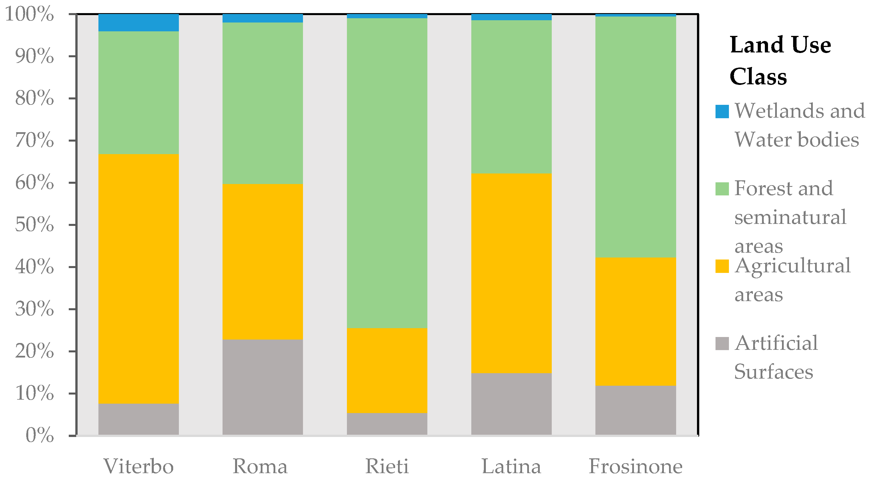
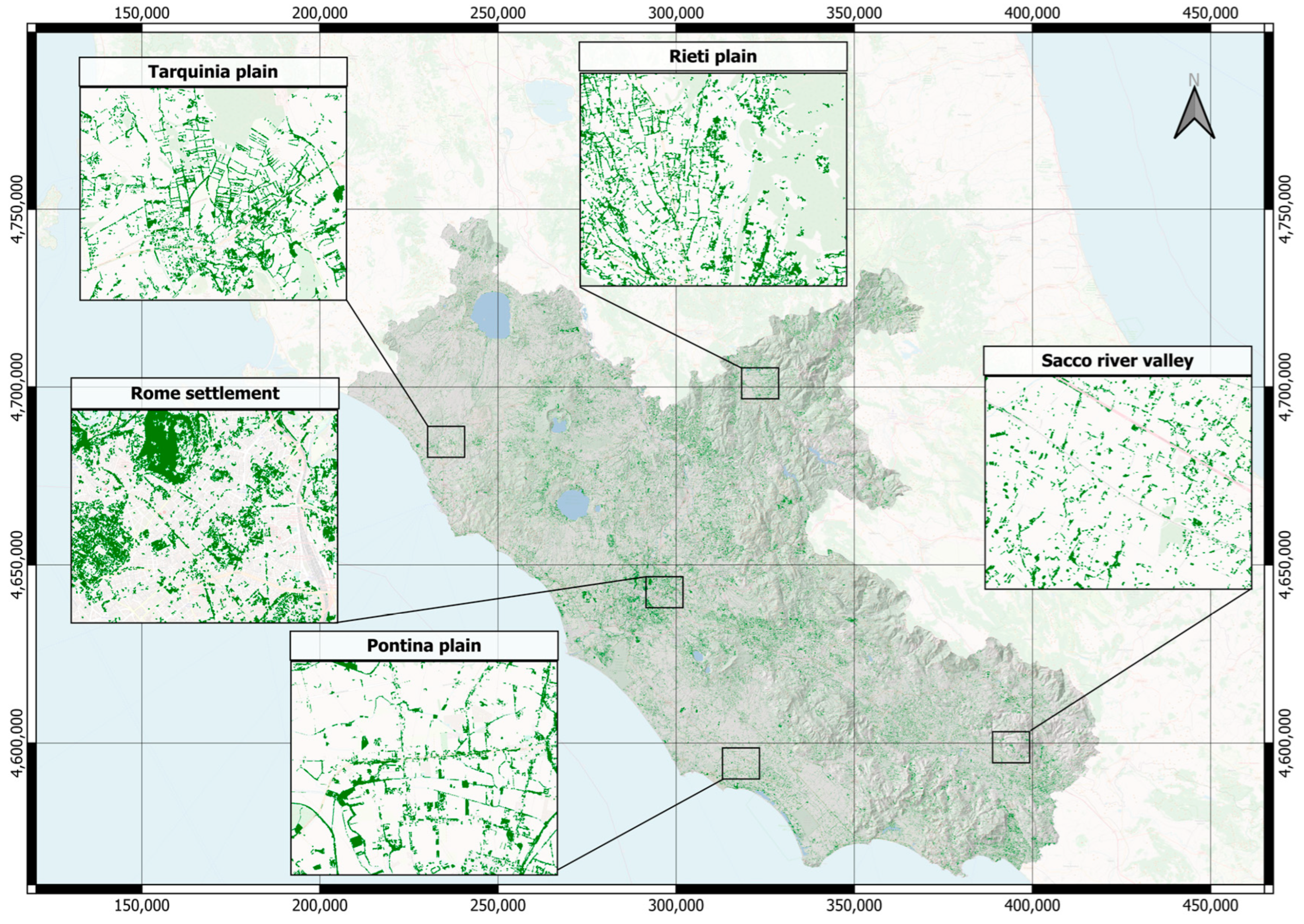
2.1. Study Area
2.2. Data
2.2.1. Orthophoto AGEA
2.2.2. Sentinel-2 Datasets
2.2.3. Forest Mask
2.2.4. Small Woody Features
2.2.5. LPIS Data
2.2.6. Reference Data
2.3. Image Processing Method
- Object-oriented classification of the AGEA orthophoto (RGB) at 2.5 m was used to identify the natural vegetation cover (NVC), which has been proven to be effective for heterogeneous areas [67,68]. For this purpose, we used the segmentation large scale mean shift algorithm implemented in the Orfeo Toolbox 7.4.0 software. The artificial neural network (ANN) algorithm was used for binary classification, distinguishing between NVC and other land use (OLU) [69];
- Mapping fog SWFs (SWF-UN): The NVC map was stratified into SWF, forest, and other land uses using spectral data, vegetation info, and CF. The classification was refined by setting the NDVI threshold and forest pixel overlap threshold, while LPIS data were used to exclude orchards and minimize errors;
- Comparison of the produced SWF-UN map with the SWF-ESA and EFA maps by standardizing data and masking forest areas using the LULCC package in R Studio [70].
2.4. Validation
3. Results
- Accuracy assessment of NVC maps and SWF-UN map: The first part of this section focuses on the accuracy assessment of the NVC map and SWF-UN map. The varying landscape complexity due to factors such as elevation or different production systems can lead to classification errors. Additionally, in Lazio, the different provinces are very diverse in terms of landscape structure, both morphologically and in terms of production systems. To take into account the factors that can affect the quality of classification, validation was performed considering different spatial scales. The validation was conducted including regional and provincial levels as well as different land use macroclasses (settlements, agricultural areas, non-settlements/agricultural areas) and altitudinal zones (areas < 300 m a.s.l., areas 300–600 m a.s.l., and areas > 600 m a.s.l.).
- Comparison with existing layers: The second part of this section examines the comparison between the SWF-UN map and other existing layers, namely the SWF-ESA and EFA. This comparison aimed to evaluate the consistency and agreement between the SWF-UN map and established datasets, providing insights into the accuracy and reliability of our mapping approach.
3.1. Accuracy Assessment of NVC Map
3.2. Accuracy Assessment of SWF Map
3.2.1. SWF Map at 2.5 m
3.2.2. SWF-UN Map at 5 m
3.2.3. SWF-ESA 2015 at 5 m
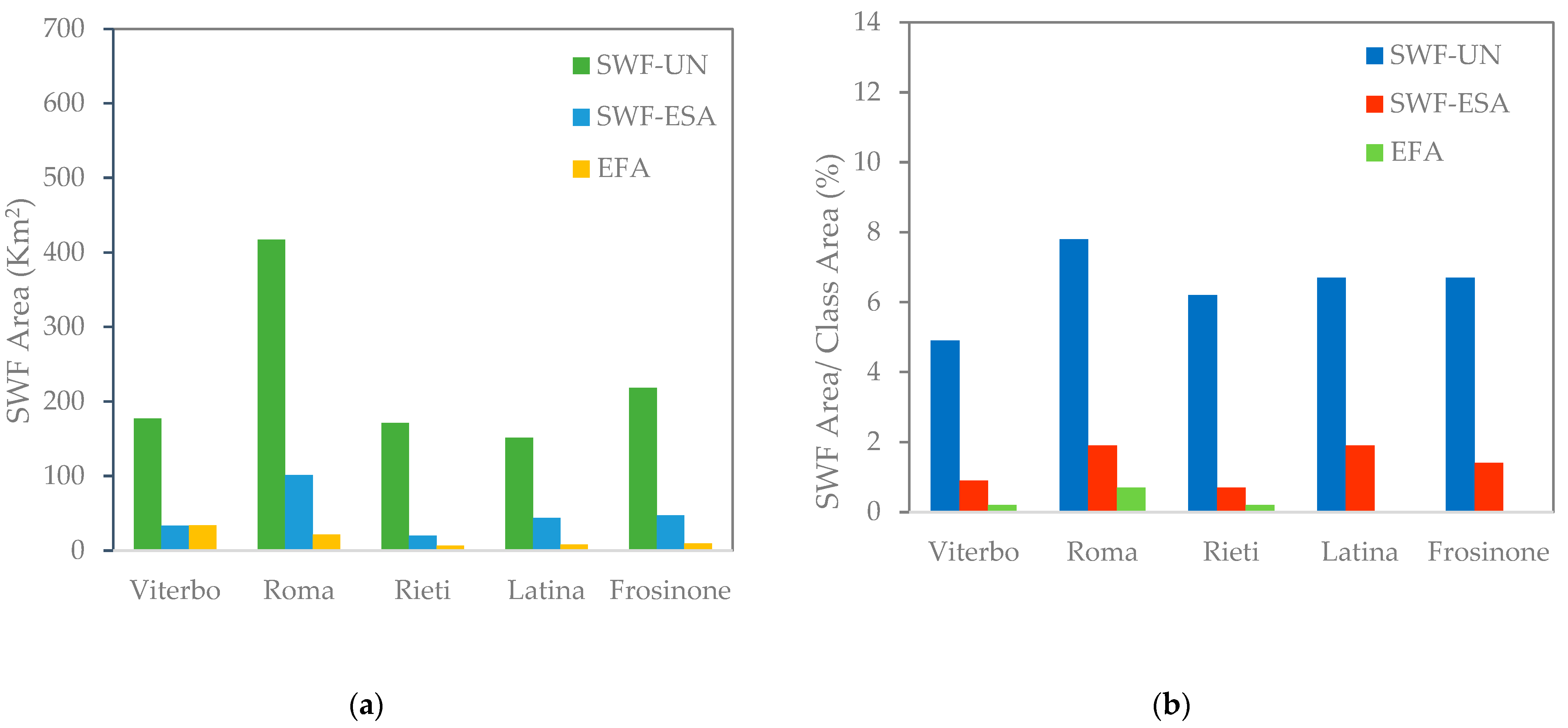
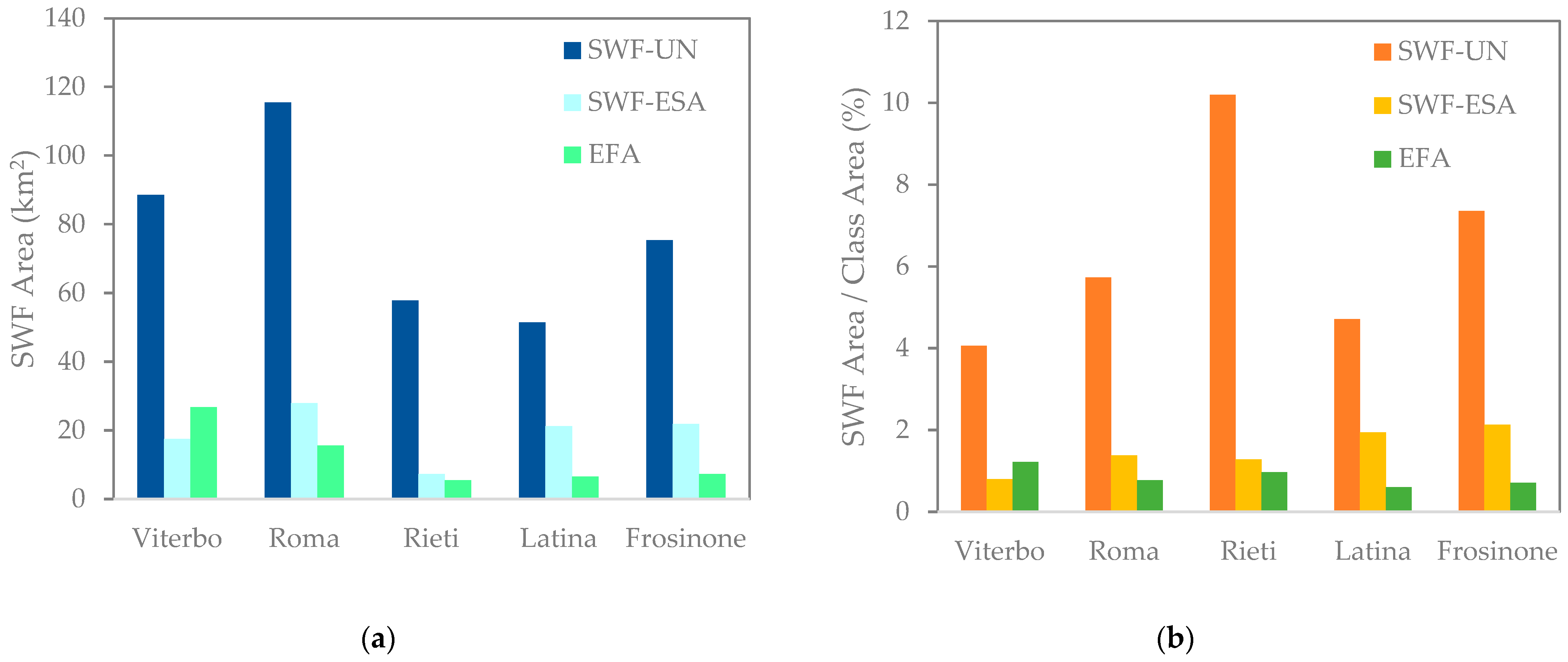
3.3. Comparison of SWF-UN Map with Other SWF Data
4. Discussion
5. Conclusions
Supplementary Materials
Author Contributions
Funding
Data Availability Statement
Acknowledgments
Conflicts of Interest
References
- Gámez-Virués:, S.; Perović, D.J.; Gossner, M.M.; Börschig, C.; Blüthgen, N.; de Jong, H.; Simons, N.K.; Klein, A.-M.; Krauss, J.; Maier, G.; et al. Landscape Simplification Filters Species Traits and Drives Biotic Homogenization. Nat. Commun. 2015, 6, 8568. [Google Scholar] [CrossRef]
- Oliver, T.H.; Morecroft, M.D. Interactions between Climate Change and Land Use Change on Biodiversity: Attribution Problems, Risks, and Opportunities. WIREs Clim. Change 2014, 5, 317–335. [Google Scholar] [CrossRef]
- Dash, P.; Punia, M. Governance and Disaster: Analysis of Land Use Policy with Reference to Uttarakhand Flood 2013, India. Int. J. Disaster Risk Reduct. 2019, 36, 101090. [Google Scholar] [CrossRef]
- García-Ruiz, J.M. The Effects of Land Uses on Soil Erosion in Spain: A Review. CATENA 2010, 81, 1–11. [Google Scholar] [CrossRef]
- Roossinck, M.J.; García-Arenal, F. Ecosystem Simplification, Biodiversity Loss and Plant Virus Emergence. Curr. Opin. Virol. 2015, 10, 56–62. [Google Scholar] [CrossRef] [PubMed]
- Zucca, C.; Canu, A.; Previtali, F. Soil Degradation by Land Use Change in an Agropastoral Area in Sardinia (Italy). CATENA 2010, 83, 46–54. [Google Scholar] [CrossRef]
- Bellefontaine, R.; Petit, S.; Pain-Orcet, M.; Deleporte, P.; Bertault, J.-G. Trees Outside Forests—Towards a Better Awareness. In Proceedings of the FAO Conservation Guide 35; FAO: Rome, Italy, 2002. [Google Scholar]
- FAO. Trees Outside Forests: Towards Rural and Urban Integrated Resources Management; FAO: Rome, Italy, 2001. [Google Scholar]
- Collier, M.J. Are Field Boundary Hedgerows the Earliest Example of a Nature-Based Solution? Environ. Sci. Policy 2021, 120, 73–80. [Google Scholar] [CrossRef]
- Frank, S.; Fürst, C.; Witt, A.; Koschke, L.; Makeschin, F. Making Use of the Ecosystem Services Concept in Regional Planning—Trade-Offs from Reducing Water Erosion. Landsc. Ecol. 2014, 29, 1377–1391. [Google Scholar] [CrossRef]
- Chen, J.; Xiao, H.; Li, Z.; Liu, C.; Ning, K.; Tang, C. How Effective Are Soil and Water Conservation Measures (SWCMs) in Reducing Soil and Water Losses in the Red Soil Hilly Region of China? A Meta-Analysis of Field Plot Data. Sci. Total Environ. 2020, 735, 139517. [Google Scholar] [CrossRef] [PubMed]
- Skole, D.L.; Mbow, C.; Mugabowindekwe, M.; Brandt, M.S.; Samek, J.H. Trees Outside of Forests as Natural Climate Solutions. Nat. Clim. Change 2021, 11, 1013–1016. [Google Scholar] [CrossRef]
- Golicz, K.; Ghazaryan, G.; Niether, W.; Wartenberg, A.C.; Breuer, L.; Gattinger, A.; Jacobs, S.R.; Kleinebecker, T.; Weckenbrock, P.; Große-Stoltenberg, A. The Role of Small Woody Landscape Features and Agroforestry Systems for National Carbon Budgeting in Germany. Land 2021, 10, 1028. [Google Scholar] [CrossRef]
- Reyes, F.; Gosme, M.; Wolz, K.J.; Lecomte, I.; Dupraz, C. Alley Cropping Mitigates the Impacts of Climate Change on a Wheat Crop in a Mediterranean Environment: A Biophysical Model-Based Assessment. Agriculture 2021, 11, 356. [Google Scholar] [CrossRef]
- Ritchie, H.; Samborska, V.; Roser, M. Urbanization; Our World Data: Oxford, UK, 2024. [Google Scholar]
- Holt-Gimenez, E. Can We Feed the World Without Destroying It? John Wiley & Sons: Hoboken, NJ, USA, 2019; ISBN 978-1-5095-2204-0. [Google Scholar]
- Sutter, L.; Albrecht, M.; Jeanneret, P. Landscape Greening and Local Creation of Wildflower Strips and Hedgerows Promote Multiple Ecosystem Services. J. Appl. Ecol. 2018, 55, 612–620. [Google Scholar] [CrossRef]
- Zomer, R.J.; Neufeldt, H.; Xu, J.; Ahrends, A.; Bossio, D.; Trabucco, A.; van Noordwijk, M.; Wang, M. Global Tree Cover and Biomass Carbon on Agricultural Land: The Contribution of Agroforestry to Global and National Carbon Budgets. Sci. Rep. 2016, 6, 29987. [Google Scholar] [CrossRef] [PubMed]
- Baudry, J.; Bunce, R.G.H.; Burel, F. Hedgerows: An International Perspective on Their Origin, Function and Management. J. Environ. Manag. 2000, 60, 7–22. [Google Scholar] [CrossRef]
- Burel, F.; Baudry, J.; Butet, A.; Clergeau, P.; Delettre, Y.; Le Coeur, D.; Dubs, F.; Morvan, N.; Paillat, G.; Petit, S.; et al. Comparative Biodiversity along a Gradient of Agricultural Landscapes. Acta Oecologica 1998, 19, 47–60. [Google Scholar] [CrossRef]
- Liccari, F.; Boscutti, F.; Bacaro, G.; Sigura, M. Connectivity, Landscape Structure, and Plant Diversity across Agricultural Landscapes: Novel Insight into Effective Ecological Network Planning. J. Environ. Manag. 2022, 317, 115358. [Google Scholar] [CrossRef] [PubMed]
- Manning, A.D.; Fischer, J.; Lindenmayer, D.B. Scattered Trees Are Keystone Structures—Implications for Conservation. Biol. Conserv. 2006, 132, 311–321. [Google Scholar] [CrossRef]
- Saunders, D.A.; Hobbs, R.J.; Margules, C.R. Biological Consequences of Ecosystem Fragmentation: A Review. Conserv. Biol. 1991, 5, 18–32. [Google Scholar] [CrossRef]
- Garratt, M.P.D.; Senapathi, D.; Coston, D.J.; Mortimer, S.R.; Potts, S.G. The Benefits of Hedgerows for Pollinators and Natural Enemies Depends on Hedge Quality and Landscape Context. Agric. Ecosyst. Environ. 2017, 247, 363–370. [Google Scholar] [CrossRef]
- Rusch, A.; Chaplin-Kramer, R.; Gardiner, M.M.; Hawro, V.; Holland, J.; Landis, D.; Thies, C.; Tscharntke, T.; Weisser, W.W.; Winqvist, C.; et al. Agricultural Landscape Simplification Reduces Natural Pest Control: A Quantitative Synthesis. Agric. Ecosyst. Environ. 2016, 221, 198–204. [Google Scholar] [CrossRef]
- Holden, J.; Grayson, R.P.; Berdeni, D.; Bird, S.; Chapman, P.J.; Edmondson, J.L.; Firbank, L.G.; Helgason, T.; Hodson, M.E.; Hunt, S.F.P.; et al. The Role of Hedgerows in Soil Functioning within Agricultural Landscapes. Agric. Ecosyst. Environ. 2019, 273, 1–12. [Google Scholar] [CrossRef]
- Ghazavi, G.; Thomas, Z.; Hamon, Y.; Marie, J.C.; Corson, M.; Merot, P. Hedgerow Impacts on Soil-Water Transfer Due to Rainfall Interception and Root-Water Uptake. Hydrol. Process. 2008, 22, 4723–4735. [Google Scholar] [CrossRef]
- Merot, P. The Influence of Hedgerow Systems on the Hydrology of Agricultural Catchments in a Temperate Climate. Agronomie 1999, 19, 655–669. [Google Scholar] [CrossRef]
- Thomas, Z.; Abbott, B.W. Hedgerows Reduce Nitrate Flux at Hillslope and Catchment Scales via Root Uptake and Secondary Effects. J. Contam. Hydrol. 2018, 215, 51–61. [Google Scholar] [CrossRef] [PubMed]
- Schnell, S.; Kleinn, C.; Ståhl, G. Monitoring Trees Outside Forests: A Review. Environ. Monit. Assess. 2015, 187, 600. [Google Scholar] [CrossRef] [PubMed]
- De Foresta, H.; Somarriba, E.; Temu, A.; Boulanger, D.; Feuilly, H.; Gauthier, M. Towards The Assessment of Trees outside Forests. A Thematic Report Prepared in the Framework of The Global Forest Resources Assessment; FAO: Rome, Italy, 2013. [Google Scholar]
- Jose, S. Agroforestry for Ecosystem Services and Environmental Benefits: An Overview. Agrofor. Syst. 2009, 76, 1–10. [Google Scholar] [CrossRef]
- Vannucci, A.; Andreoli, M.; Rovai, M. Land Use Change and Disappearance of Hedgerows in a Tuscan Rural Landscape: A Discussion on Policy Tools to Revert This Trend. Sustainability 2022, 14, 13341. [Google Scholar] [CrossRef]
- Gulinck, H.; Marcheggiani, E.; Verhoeve, A.; Bomans, K.; Dewaelheyns, V.; Lerouge, F.; Galli, A. The Fourth Regime of Open Space. Sustainability 2018, 10, 2143. [Google Scholar] [CrossRef]
- Malkoç, E.; Rüetschi, M.; Ginzler, C.; Waser, L.T. Countrywide Mapping of Trees Outside Forests Based on Remote Sensing Data in Switzerland. Int. J. Appl. Earth Obs. Geoinf. 2021, 100, 102336. [Google Scholar] [CrossRef]
- Mosquera-Losada, M.R.; Santiago-Freijanes, J.J.; Rois-Díaz, M.; Moreno, G.; den Herder, M.; Aldrey-Vázquez, J.A.; Ferreiro-Domínguez, N.; Pantera, A.; Pisanelli, A.; Rigueiro-Rodríguez, A. Agroforestry in Europe: A Land Management Policy Tool to Combat Climate Change. Land Use Policy 2018, 78, 603–613. [Google Scholar] [CrossRef]
- Rigueiro-Rodríguez, A.; Fernández-Núñez, E.; González-Hernández, P.; McAdam, J.H.; Mosquera-Losada, M.R. Agroforestry Systems in Europe: Productive, Ecological and Social Perspectives. In Agroforestry in Europe: Current Status and Future Prospects; Rigueiro-Rodróguez, A., McAdam, J., Mosquera-Losada, M.R., Eds.; Springer: Dordrecht, The Netherlands, 2009; pp. 43–65. ISBN 978-1-4020-8272-6. [Google Scholar]
- Álvarez, F.A.; Mediavilla, G.G.; Estébanez, N.L. Environmental, Demographic and Policy Drivers of Change in Mediterranean Hedgerow Landscape (Central Spain). Land Use Policy 2021, 103, 105342. [Google Scholar] [CrossRef]
- Santiago-Freijanes, J.J.; Rigueiro-Rodríguez, A.; Aldrey, J.A.; Moreno, G.; den Herder, M.; Burgess, P.; Mosquera-Losada, M.R. Understanding Agroforestry Practices in Europe through Landscape Features Policy Promotion. Agrofor. Syst. 2018, 92, 1105–1115. [Google Scholar] [CrossRef]
- García de León, D.; Rey Benayas, J.M.; Andivia, E. Contributions of Hedgerows to People: A Global Meta-Analysis. Front. Conserv. Sci. 2021, 2, 789612. [Google Scholar] [CrossRef]
- Thomas, N.; Baltezar, P.; Lagomasino, D.; Stovall, A.; Iqbal, Z.; Fatoyinbo, L. Trees Outside Forests Are an Underestimated Resource in a Country with Low Forest Cover. Sci. Rep. 2021, 11, 7919. [Google Scholar] [CrossRef] [PubMed]
- Santoro, A.; Piras, F.; Fiore, B.; Frassinelli, N.; Bazzurro, A.; Agnoletti, M. The Role of Trees Outside Forests in the Cultural Landscape of the Colline Del Prosecco UNESCO Site. Forests 2022, 13, 514. [Google Scholar] [CrossRef]
- Alvarez, F.A.; Gomez-Mediavilla, G.; López-Estébanez, N.; Holgado, P.M. Classification of Mediterranean Hedgerows: A Methodological Approximation. MethodsX 2021, 8, 101355. [Google Scholar] [CrossRef] [PubMed]
- Fehrmann, L.; Seidel, D.; Krause, B.; Kleinn, C. Sampling for Landscape Elements—A Case Study from Lower Saxony, Germany. Environ. Monit. Assess 2014, 186, 1421–1430. [Google Scholar] [CrossRef]
- León, M.C.; Harvey, C.A. Live Fences and Landscape Connectivity in a Neotropical Agricultural Landscape. Agrofor. Syst. 2006, 68, 15–26. [Google Scholar] [CrossRef]
- Perry, C.H.; Woodall, C.W.; Liknes, G.C.; Schoeneberger, M.M. Filling the Gap: Improving Estimates of Working Tree Resources in Agricultural Landscapes. Agrofor. Syst. 2009, 75, 91–101. [Google Scholar] [CrossRef]
- Zomer, R.J.; Trabucco, A.; Coe, R.; Place, F.; Van Noordwijk, M.; Xu, J.C. Trees on Farms: An Update and Reanalysis of Agroforestry’s Global Extent and Socio-Ecological Characteristics; World Agroforestry Centre (ICRAF): Nairobi, Kenya, 2014. [Google Scholar]
- Foschi, P.; Smith, D. Detecting Subpixel Woody Vegetation in Digital Imagery Using Two Artificial Intelligence Approaches. Photogramm. Eng. Remote Sens. 1997, 63, 493–500. [Google Scholar]
- Thornton, M.W.; Atkinson, P.M.; Holland, D.A. A Linearised Pixel-Swapping Method for Mapping Rural Linear Land Cover Features from Fine Spatial Resolution Remotely Sensed Imagery. Comput. Geosci. 2007, 33, 1261–1272. [Google Scholar] [CrossRef]
- Thornton, M.W.; Atkinson, P.M.; Holland, D.A. Sub-pixel Mapping of Rural Land Cover Objects from Fine Spatial Resolution Satellite Sensor Imagery Using Super-resolution Pixel-swapping. Int. J. Remote Sens. 2006, 27, 473–491. [Google Scholar] [CrossRef]
- Sarti, M.; Ciolfi, M.; Lauteri, M.; Paris, P.; Chiocchini, F. Trees Outside Forest in Italian Agroforestry Landscapes: Detection and Mapping Using Sentinel-2 Imagery. Eur. J. Remote Sens. 2021, 54, 609–623. [Google Scholar] [CrossRef]
- Brandt, J.; Stolle, F. A Global Method to Identify Trees Outside of Closed-Canopy Forests with Medium-Resolution Satellite Imagery. Int. J. Remote Sens. 2021, 42, 1713–1737. [Google Scholar] [CrossRef]
- Ottosen, T.-B.; Petch, G.; Hanson, M.; Skjøth, C.A. Tree Cover Mapping Based on Sentinel-2 Images Demonstrate High Thematic Accuracy in Europe. Int. J. Appl. Earth Obs. Geoinf. 2020, 84, 101947. [Google Scholar] [CrossRef]
- Boggs, G.S. Assessment of SPOT 5 and QuickBird Remotely Sensed Imagery for Mapping Tree Cover in Savannas. Int. J. Appl. Earth Obs. Geoinf. 2010, 12, 217–224. [Google Scholar] [CrossRef]
- Liknes, G.C.; Perry, C.H.; Meneguzzo, D.M. Assessing Tree Cover in Agricultural Landscapes Using High-Resolution Aerial Imagery. J. Terr. Obs. 2010, 2, 38–55. [Google Scholar]
- Meneguzzo, D.M.; Liknes, G.C.; Nelson, M.D. Mapping Trees Outside Forests Using High-Resolution Aerial Imagery: A Comparison of Pixel- and Object-Based Classification Approaches. Environ. Monit. Assess 2013, 185, 6261–6275. [Google Scholar] [CrossRef]
- Puissant, A.; Rougier, S.; Stumpf, A. Object-Oriented Mapping of Urban Trees Using Random Forest Classifiers. Int. J. Appl. Earth Obs. Geoinf. 2014, 26, 235–245. [Google Scholar] [CrossRef]
- Bolyn, C.; Lejeune, P.; Michez, A.; Latte, N. Automated Classification of Trees Outside Forest for Supporting Operational Management in Rural Landscapes. Remote Sens. 2019, 11, 1146. [Google Scholar] [CrossRef]
- Luscombe, D.J.; Gatis, N.; Anderson, K.; Carless, D.; Brazier, R.E. Rapid, Repeatable Landscape-Scale Mapping of Tree, Hedgerow, and Woodland Habitats (THaW), Using Airborne LiDAR and Spaceborne SAR Data. Ecol. Evol. 2023, 13, e10103. [Google Scholar] [CrossRef]
- Moccia, B.; Mineo, C.; Ridolfi, E.; Russo, F.; Napolitano, F. Probability Distributions of Daily Rainfall Extremes in Lazio and Sicily, Italy, and Design Rainfall Inferences. J. Hydrol. Reg. Stud. 2021, 33, 100771. [Google Scholar] [CrossRef]
- Salvati, L.; Perini, L.; Sabbi, A.; Bajocco, S. Climate Aridity and Land Use Changes: A Regional-Scale Analysis: Climate Aridity and Land Use Changes. Geogr. Res. 2012, 50, 193–203. [Google Scholar] [CrossRef]
- Fraucqueur, L.; Morin, N.; Masse, A.; Remy, P.-Y.; Hugé, J.; Kenner, C.; Dazin, F.; Desclée, B.; Sannier, C. A New Copernicus High Resolution Layer at Pan-European Scale: Small Woody Features. In Proceedings of the Remote Sensing for Agriculture, Ecosystems, and Hydrology XXI, Strasbourg, France, 21 October 2019; Neale, C.M., Maltese, A., Eds.; SPIE: Strasbourg, France, 2019; p. 37. [Google Scholar]
- European Court of Auditors. The Land Parcel Identification System: A Useful Tool to Determine the Eligibility of Agricultural Land—But Its Management Could Be Further Improved. Special Report No 25, 2016; Publications Office of the European Union: Luxembourg, Luxembourg, 2016; ISBN 978-92-872-5967-7.
- QGIS Development Team. QGIS Geographic Information System 2024; QGIS Development Team: Solothurn, Switzerland, 2024. [Google Scholar]
- Farr, T.G.; Rosen, P.A.; Caro, E.; Crippen, R.; Duren, R.; Hensley, S.; Kobrick, M.; Paller, M.; Rodriguez, E.; Roth, L.; et al. The Shuttle Radar Topography Mission. Rev. Geophys. 2007, 45, 2005RG000183. [Google Scholar] [CrossRef]
- Chirici, G.; Fattori, C.; Cutolo, N.; Tufano, M.; Corona, P.; Barbati, A.; Blasi, C.; Copiz, R.; Rossi, L.; Biscontini, D.; et al. Map of the Natural and Semi-Natural Environments and Forest Types Map for the Latium Region (Italy). For. -Riv. Selvic. Ecol. For. 2014, 11, 65–71. [Google Scholar] [CrossRef]
- Benz, U.C.; Hofmann, P.; Willhauck, G.; Lingenfelder, I.; Heynen, M. Multi-Resolution, Object-Oriented Fuzzy Analysis of Remote Sensing Data for GIS-Ready Information. ISPRS J. Photogramm. Remote Sens. 2004, 58, 239–258. [Google Scholar] [CrossRef]
- Burnett, C.; Blaschke, T. A Multi-Scale Segmentation/Object Relationship Modelling Methodology for Landscape Analysis. Ecol. Model. 2003, 168, 233–249. [Google Scholar] [CrossRef]
- Pádua, L.; Adao, T.; Hruska, J.; Guimaraes, N.; Marques, P.; Peres, E.; Sousa, J.J. Vineyard Classification Using Machine Learning Techniques Applied to RGB-UAV Imagery. In Proceedings of the IGARSS 2020–2020 IEEE International Geoscience and Remote Sensing Symposium, Waikoloa, HI, USA, 26 September 2020; IEEE: Waikoloa, HI, USA, 2020; pp. 6309–6312. [Google Scholar]
- Moulds, S.; Buytaert, W.; Mijic, A. An Open and Extensible Framework for Spatially Explicit Land Use Change Modelling: The Lulcc R Package. Geosci. Model Dev. 2015, 8, 3215–3229. [Google Scholar] [CrossRef]
- Aho, K. Asbio: A Collection of Statistical Tools for Biologists; CRC Press: Boca Raton, FL, USA, 2024. [Google Scholar]
- Centeri, C.; Renes, H.; Roth, M.; Kruse, A.; Eiter, S.; Kapfer, J.; Santoro, A.; Agnoletti, M.; Emanueli, F.; Sigura, M.; et al. Wooded Grasslands as Part of the European Agricultural Heritage. In Biocultural Diversity in Europe; Agnoletti, M., Emanueli, F., Eds.; Springer International Publishing: Cham, Switzerland, 2016; pp. 75–103. ISBN 978-3-319-26315-1. [Google Scholar]
- Oreszczyn, S.; Lane, A. The Meaning of Hedgerows in the English Landscape: Different Stakeholder Perspectives and the Implications for Future Hedge Management. J. Environ. Manag. 2000, 60, 101–118. [Google Scholar] [CrossRef]
- TUFF Italian Government. Decreto Legislativo 03/04/2018 n. 34—Testo unico in Materia di Foreste e Filiere Forestali (TUFF); TUFF Italian Government: Rome, Italy, 2018.
- Danijel, I.; Nataša, P.; Jaša, G.V.; Daša, D.; Mitja, K.; Sonja, Š.; Igor, Ž.; Jure, Č.; Petra, R.N.; Štefan, K.; et al. A Decision Support System for Effective Implementation of Agro-Environmental Measures Targeted at Small Woody Landscape Features: The Case Study of Slovenia. Landsc. Urban Plan. 2024, 247, 105064. [Google Scholar] [CrossRef]
- Ducrot, D.; Masse, A.; Ncibi, A. Hedgerow Detection in HRS and VHRS Images from Different Source (Optical, Radar). In Proceedings of the 2012 IEEE International Geoscience and Remote Sensing Symposium, Munich, Germany, 22–27 July 2012; pp. 6348–6351. [Google Scholar]
- European Commission. Communication from the Commission to the European Parliament, the Council, the European Economic and Social Committee and the Committee of the Regions a Farm to Fork Strategy for a Fair, Healthy and Environmentally-Friendly Food System; European Commission: Brussels, Belgium, 2020. [Google Scholar]
- Ministry of University and Research. Project PRIN 2020—Sector ERC LS9—Call 2020 Prot. 2020 EMLWTN—Eye-Land: A Crowd-Sensing Geospatial Database for the Monitoring of Rural Areas; Ministry of University and Research: Rome, Italy, 2020.


| Classified Data | |||||
|---|---|---|---|---|---|
| Reference data | NVC | OLU | Total | PA (%) | |
| NVC | 2067 | 210 | 2277 | 0.91 | |
| OLU | 337 | 2386 | 2723 | 0.88 | |
| Total | 2404 | 2596 | 5000 | - | |
| UA (%) | 0.86 | 0.92 | - | - | |
| Validation Based on | Number of Test Points | OA (%) | UA (%) | PA (%) | |
|---|---|---|---|---|---|
| Lazio Region | 3430 | 86.7 | 72.2 | 90.5 | |
| Land Use Class | Settlements | 191 | 82.7 | 85.2 | 88.9 |
| Agricultural areas | 1474 | 73.7 | 70.4 | 91.3 | |
| Non-settlements/Agricultural areas | 1765 | 98.0 | 75.9 | 83.0 | |
| Provinces | Viterbo | 735 | 77.9 | 60.7 | 85.0 |
| Roma | 1085 | 87.6 | 79.1 | 89.0 | |
| Rieti | 625 | 93.1 | 77.9 | 90.7 | |
| Latina | 424 | 77.1 | 57.6 | 96.7 | |
| Frosinone | 561 | 96.6 | 92.0 | 97.2 | |
| Elevation (m a.s.l.) | <300 | 1805 | 80.7 | 70.9 | 89.1 |
| 300–600 | 1177 | 92.1 | 77.0 | 94.2 | |
| >600 | 448 | 96.6 | 65.5 | 100 |
| Validation Based on | Number of Test Points | OA (%) | UA (%) | PA (%) | |
|---|---|---|---|---|---|
| Lazio Region | 3430 | 86.7 | 81.9 | 78.5 | |
| Land Use Class | Settlements | 191 | 80.1 | 85.2 | 83.8 |
| Agricultural areas | 1474 | 77.5 | 81.8 | 78.5 | |
| Non-settlements/Agricultural areas | 1765 | 95.0 | 74.5 | 66.0 | |
| Provinces | Viterbo | 735 | 84.4 | 80.7 | 74.6 |
| Roma | 1085 | 85.8 | 82.3 | 79.2 | |
| Rieti | 625 | 91.8 | 83.7 | 79.4 | |
| Latina | 424 | 82.6 | 72.7 | 82.8 | |
| Frosinone | 561 | 88.8 | 91.7 | 78.2 | |
| Elevation (m a.s.l.) | <300 | 1805 | 82.0 | 79.5 | 78.0 |
| 300–600 | 1177 | 90.9 | 92.7 | 79.0 | |
| >600 | 448 | 94.4 | 65.4 | 89.5 |
| Validation Based on | Number of Test Points | OA (%) | UA (%) | PA (%) | |
|---|---|---|---|---|---|
| Lazio Region | 3430 | 75.5 | 93.7 | 23.9 | |
| Land Use Class | Settlements | 191 | 53.9 | 94.6 | 29.9 |
| Agricultural areas | 1474 | 56.0 | 93.3 | 23.4 | |
| Non-settlements/Agricultural areas | 1765 | 93.9 | 100* | 16.9 | |
| Provinces | Viterbo | 735 | 72.9 | 97.6 | 19.2 |
| Roma | 1085 | 73.1 | 93.7 | 28.7 | |
| Rieti | 625 | 84.6 | 100 * | 19.6 | |
| Latina | 424 | 74.2 | 83.3 | 28.7 | |
| Frosinone | 561 | 74.3 | 100 * | 16.9 | |
| Elevation (m a.s.l.) | <300 | 1805 | 68.1 | 92.3 | 26.1 |
| 300–600 | 1177 | 80.1 | 100 * | 16.5 | |
| >600 | 448 | 93.3 | 100 * | 26.3 |
| SWF-UN | |||
|---|---|---|---|
| 0 | 1 | ||
| SWF-ESA | 0 | 16,001 | 996 |
| 1 | 107 | 138 | |
| EFA | 0 | 16,058 | 1105 |
| 1 | 50 | 29 | |
Disclaimer/Publisher’s Note: The statements, opinions and data contained in all publications are solely those of the individual author(s) and contributor(s) and not of MDPI and/or the editor(s). MDPI and/or the editor(s) disclaim responsibility for any injury to people or property resulting from any ideas, methods, instructions or products referred to in the content. |
© 2024 by the authors. Licensee MDPI, Basel, Switzerland. This article is an open access article distributed under the terms and conditions of the Creative Commons Attribution (CC BY) license (https://creativecommons.org/licenses/by/4.0/).
Share and Cite
Patriarca, A.; Caputi, E.; Gatti, L.; Marcheggiani, E.; Recanatesi, F.; Rossi, C.M.; Ripa, M.N. Wide-Scale Identification of Small Woody Features of Landscape from Remote Sensing. Land 2024, 13, 1128. https://doi.org/10.3390/land13081128
Patriarca A, Caputi E, Gatti L, Marcheggiani E, Recanatesi F, Rossi CM, Ripa MN. Wide-Scale Identification of Small Woody Features of Landscape from Remote Sensing. Land. 2024; 13(8):1128. https://doi.org/10.3390/land13081128
Chicago/Turabian StylePatriarca, Alessio, Eros Caputi, Lorenzo Gatti, Ernesto Marcheggiani, Fabio Recanatesi, Carlo Maria Rossi, and Maria Nicolina Ripa. 2024. "Wide-Scale Identification of Small Woody Features of Landscape from Remote Sensing" Land 13, no. 8: 1128. https://doi.org/10.3390/land13081128
APA StylePatriarca, A., Caputi, E., Gatti, L., Marcheggiani, E., Recanatesi, F., Rossi, C. M., & Ripa, M. N. (2024). Wide-Scale Identification of Small Woody Features of Landscape from Remote Sensing. Land, 13(8), 1128. https://doi.org/10.3390/land13081128