
The Improved SBAS-InSAR Technique Reveals Three-Dimensional Glacier Collapse: A Case Study in the Qinghai–Tibet Plateau


Abstract
1. Introduction
2. Study Area and Datasets
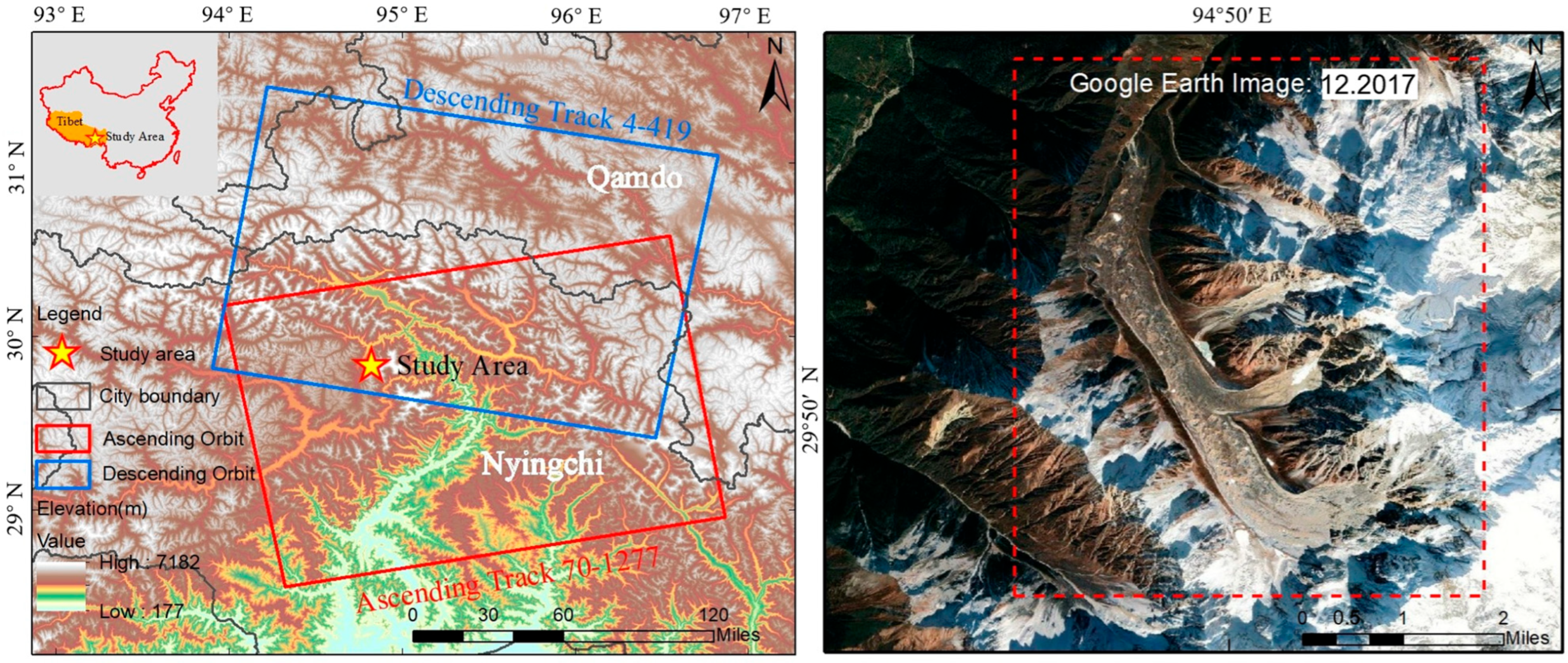
2.1. Study Area
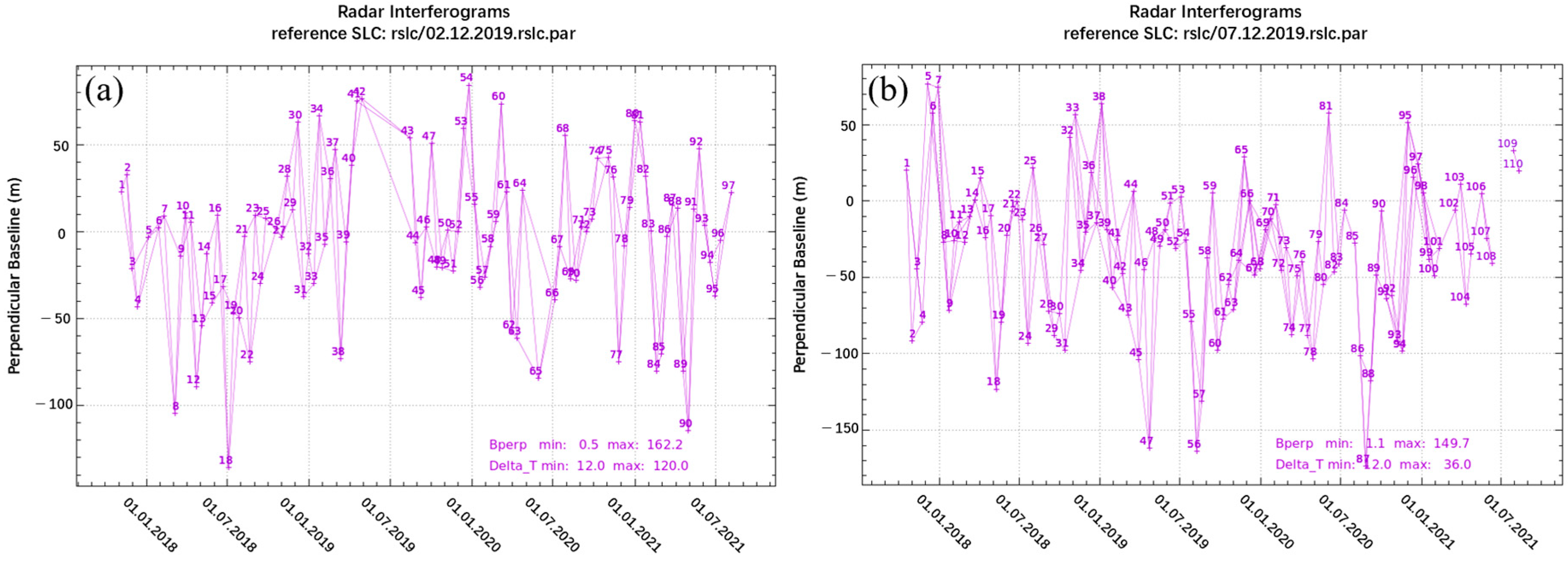
2.2. Datasets
3. Methods
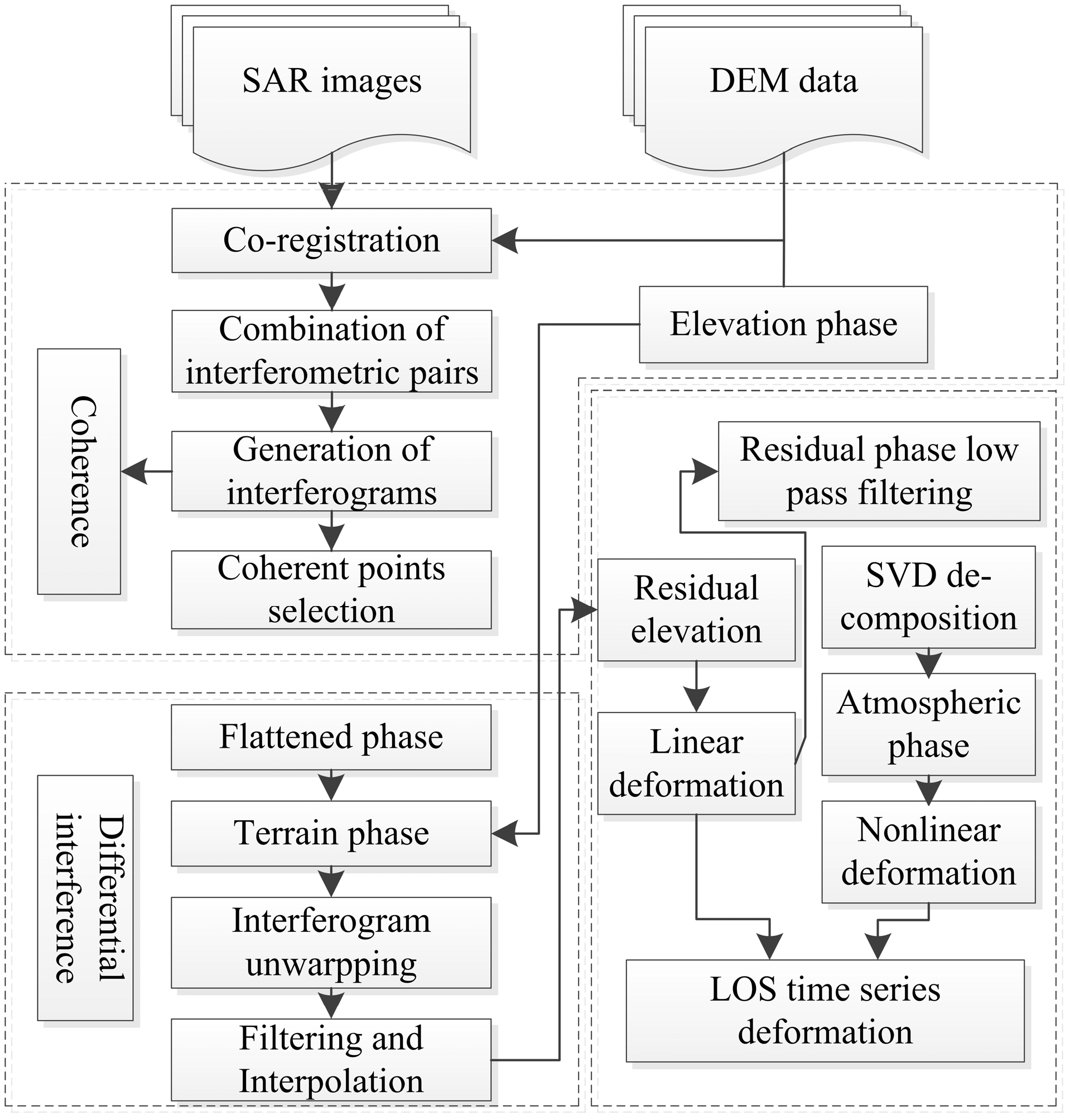
3.1. Improved SBAS-InSAR
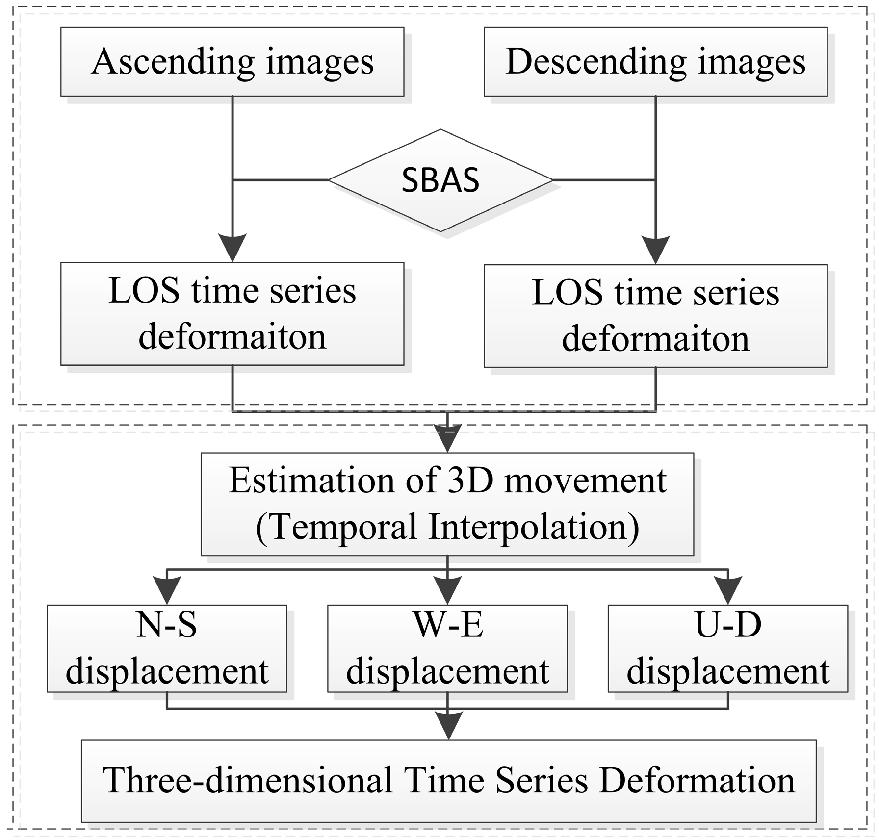
3.2. Three-Dimensional Decomposition
4. Results
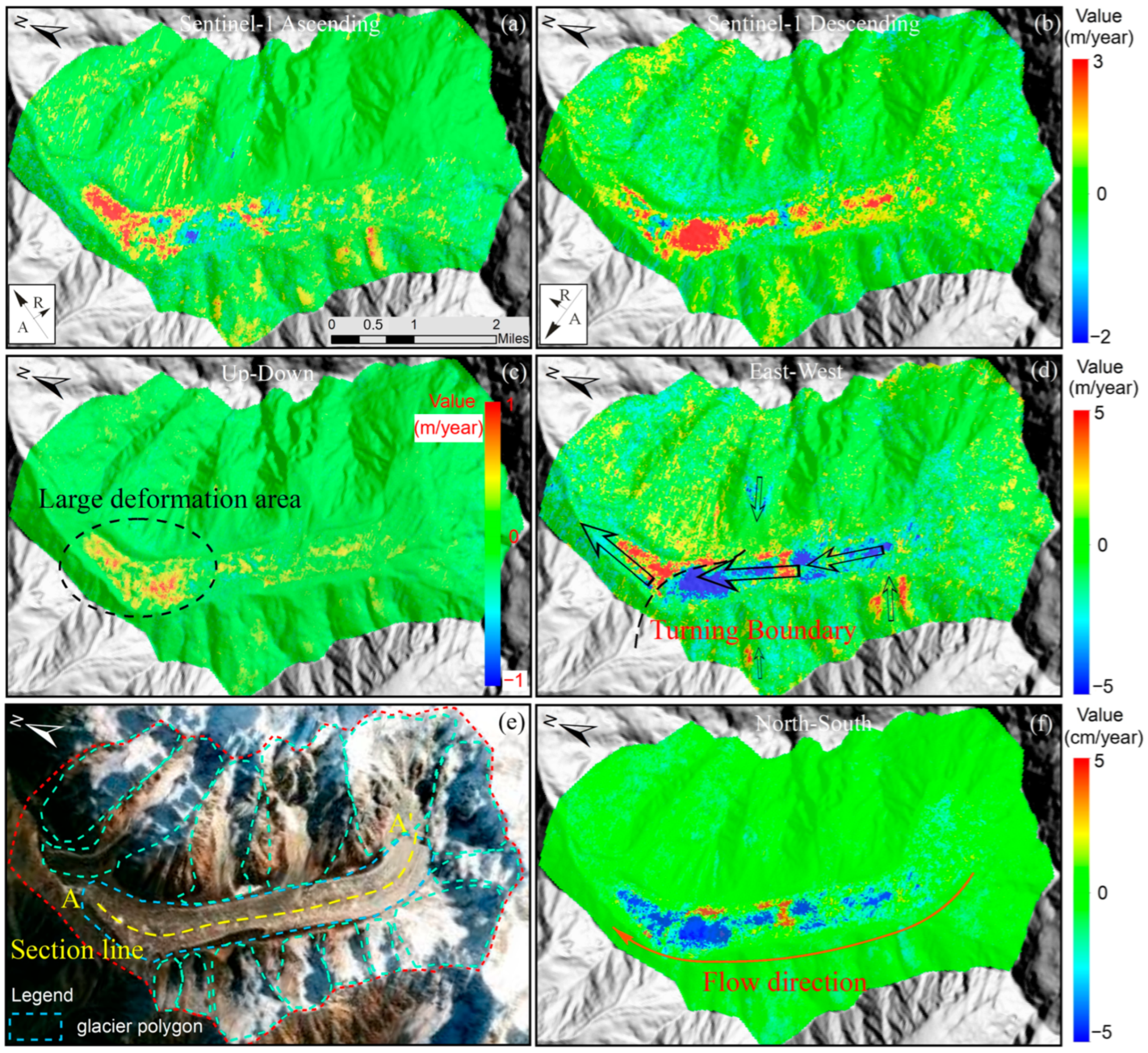
4.1. Three-Dimensional Deformation of the Glacier
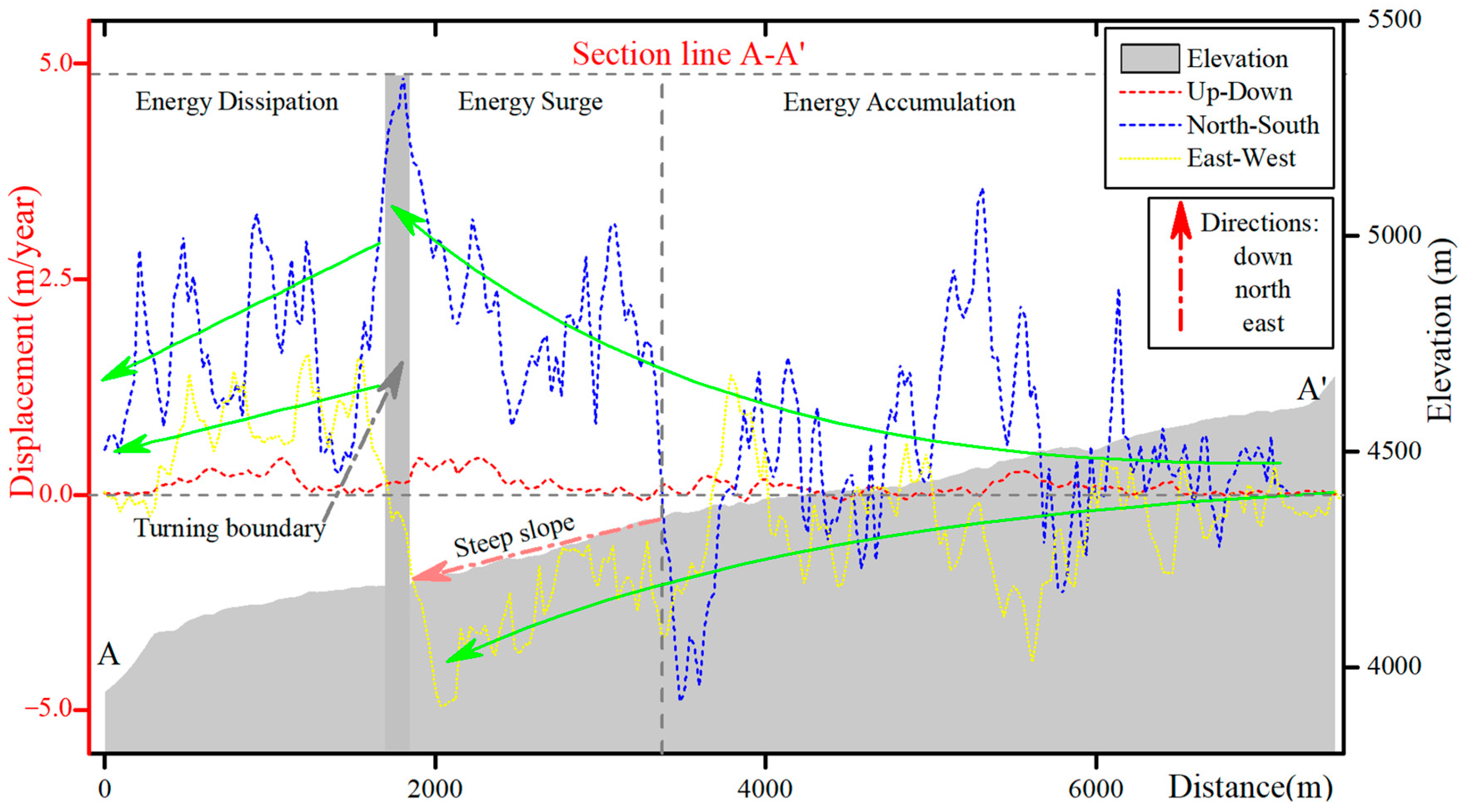
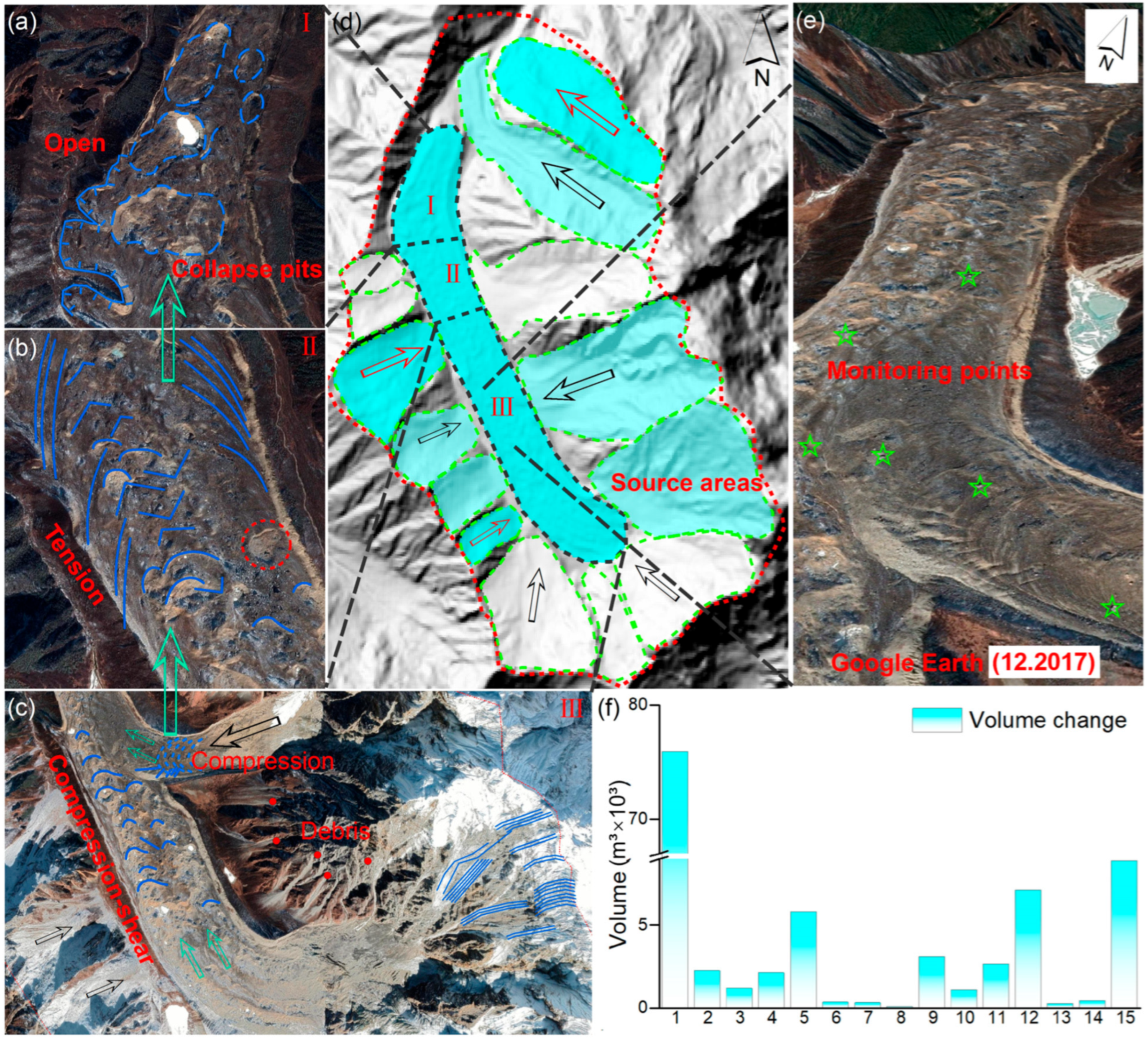
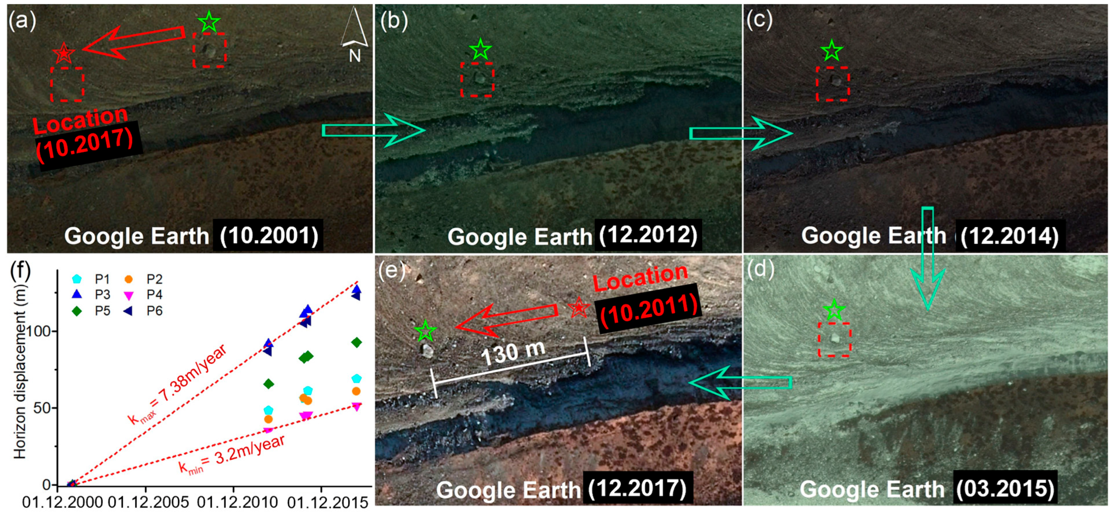
4.2. Migration Process of Glacier Material
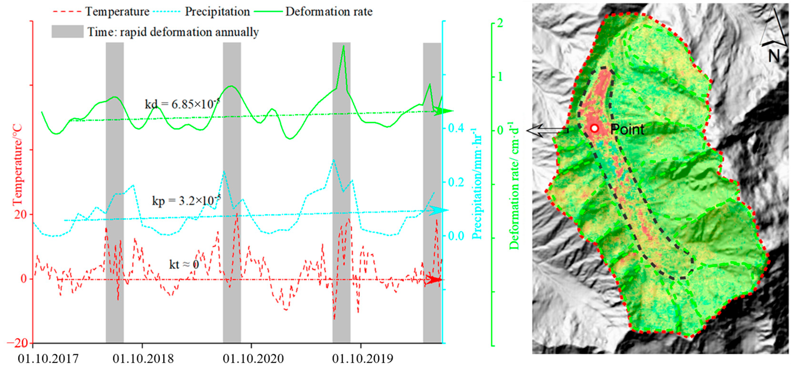
4.3. Link between Time Series Glacial Movement and Climate Change
5. Discussion
5.1. Method Optimization and Integration
5.2. Relationship between Glacier and Climate Change
6. Conclusions
Author Contributions
Funding
Data Availability Statement
Conflicts of Interest
References
- Zhu, H.; Shao, X.; Zhang, H.; Asad, F.; Sigdel, S.R.; Huang, R.; Li, Y.; Liu, W.; Muhammad, S.; Hussain, I.; et al. Trees record changes of the temperate glaciers on the Tibetan Plateau: Potential and uncertainty. Glob. Planet. Chang. 2019, 173, 15–23. [Google Scholar] [CrossRef]
- Zhang, Z.; Liu, S.; Zhang, Y.; Wei, J.; Jiang, Z.; Wu, K. Glacier variations at Aru Co in western Tibet from 1971 to 2016 derived from remote-sensing data. J. Glaciol. 2018, 64, 397–406. [Google Scholar] [CrossRef]
- Yao, J.; Yao, X.; Zhao, Z.; Liu, X. Performance comparison of Landslide susceptibility mapping under multiple machine-learning based models considering InSAR deformation: A case study of the upper Jinsha River. Geomat. Nat. Hazards Risk 2023, 14, 2212833. [Google Scholar] [CrossRef]
- Huggel, C.; Zgraggen-Oswald, S.; Haeberli, W.; Kääb, A.; Polkvoj, A.; Galushkin, I.; Evans, S.G. The 2002 rock/ice avalanche at Kolka/Karmadon, Russian Caucasus: Assessment of extraordinary avalanche formation and mobility, and application of QuickBird satellite imagery. Nat. Hazards Earth Syst. Sci. 2005, 5, 173–187. [Google Scholar] [CrossRef]
- Bolch, T.; Buchroithner, M.F.; Peters, J.; Baessler, M.; Bajracharya, S. Identification of glacier motion and potentially dangerous glacial lakes in the Mt. Everest region/Nepal using spaceborne imagery. Nat. Hazards Earth Syst. Sci. 2008, 8, 1329–1340. [Google Scholar] [CrossRef]
- Shangguan, D.; Liu, S.; Ding, Y.; Guo, W.; Xu, B.; Xu, J.; Jiang, Z. Characterizing the May 2015 Karayaylak Glacier surge in the eastern Pamir Plateau using remote sensing. J. Glaciol. 2016, 62, 944–953. [Google Scholar] [CrossRef]
- Tian, L.; Yao, T.; Gao, Y.; Thompson, L.; Mosley-Thompson, E.; Muhammad, S.; Zong, J.; Wang, C.; Jin, S.; Li, Z. Two glaciers collapse in western Tibet. J. Glaciol. 2017, 63, 194–197. [Google Scholar] [CrossRef]
- Yang, L.; Zhao, C.; Lu, Z.; Yang, C.; Zhang, Q. Three-Dimensional Time Series Movement of the Cuolangma Glaciers, Southern Tibet with Sentinel-1 Imagery. Remote Sens. 2020, 12, 3466. [Google Scholar] [CrossRef]
- Zhou, Y.; Li, Z.; Li, J.; Zhao, R.; Ding, X. Glacier mass balance in the Qinghai-Tibet Plateau and its surroundings from the mid-1970s to 2000 based on Hexagon KH-9 and SRTM DEMs. Remote Sens. Environ. 2018, 210, 96–112. [Google Scholar] [CrossRef]
- Yao, J.; Wang, Y.; Wang, T.; Zhang, B.; Wu, Y.; Yao, X.; Zhao, Z.; Zhu, S. Assessing geological hazard susceptibility and impacts of climate factors in the eastern Himalayan syntaxis region. Landslides 2024. [Google Scholar] [CrossRef]
- Yao, J.; Yao, X.; Wang, Y.; Zhao, Z.; Liu, X. Current active fault distribution and slip rate along the middle section of the Jiali-Chayu fault from Sentinel-1 InSAR observations (2017–2022). Earth Planets Space 2024, 76, 21. [Google Scholar] [CrossRef]
- Amitrano, D.; Guida, R.; Di Martino, G.; Iodice, A. Glacier Monitoring Using Frequency Domain Offset Tracking Applied to Sentinel-1 Images: A Product Performance Comparison. Remote Sens. 2019, 11, 1322. [Google Scholar] [CrossRef]
- Kwok, R.; Fahnestock, M.A. Ice sheet motion and topography from radar interferometry. IEEE Trans. Geosci. Remote Sens. 1996, 34, 189–200. [Google Scholar] [CrossRef]
- Zhou, Y.; Zhou, C.; Dongchen, E.; Wang, Z. A Baseline-combination method for precise estimation of ice motion in Antarctica. IEEE Trans. Geosci. Remote Sens. 2014, 52, 5790–5797. [Google Scholar] [CrossRef]
- Zhou, Y.; Zhou, C.; Deng, F.; Dongchen, E.; Liu, H.; Wen, Y. Improving InSAR elevation models in Antarctica using laser altimetry, accounting for ice motion, orbital errors and atmospheric delays. Remote Sens. Environ. 2015, 162, 112–118. [Google Scholar] [CrossRef]
- Berardino, P.; Fornaro, G.; Lanari, R.; Sansosti, E. A New Algorithm for Surface Deformation Monitoring Based on Small Baseline Differential SAR Interferograms. IEEE Trans. Geosci. Remote Sens. 2002, 40, 2375–2383. [Google Scholar] [CrossRef]
- Meng, Q.; Confuorto, P.; Peng, Y.; Raspini, F.; Bianchini, S.; Han, S.; Liu, H.; Casagli, N. Regional recognition and classification of active loess landslides using two-dimentional deformation derived from Sentinel-1 Interferometric Radar Data. Remote Sens. 2020, 12, 1541. [Google Scholar] [CrossRef]
- Goldstein, R.M.; Werner, C.L. Radar interferogram filtering for geophysical applications. Geophys. Res. Lett. 1998, 25, 4035–4038. [Google Scholar] [CrossRef]
- Costantini, M. A novel phase unwrapping method based on network programming. IEEE Trans. Geosci. Remote Sens. 1998, 36, 813–821. [Google Scholar] [CrossRef]
- Lyons, S.; Sandwell, D. Fault creep along the southern San Andreas from interferometric synthetic aperture radar, permanent scatterers, and stacking. J. Geophys. Res.-Solid Earth 2003, 108, 2047. [Google Scholar] [CrossRef]
- Yao, J.; Yao, X.; Wu, Z.; Liu, X. Research on Surface Deformation of Ordos Coal Mining Area by Integrating Multitemporal D-InSAR and Offset Tracking Technology. J. Sens. 2021, 2021, 6660922. [Google Scholar] [CrossRef]
- Rocca, F. 3D motion recovery from multi-angle and/or left right interferometry. In Proceedings of the Third International Workshop on ERS SAR, Frascati, Italy, 1–5 December 2003. [Google Scholar]
- Wright, T.; Parsons, B.; Lu, Z. Toward mapping surface deformation in three dimensions using InSAR. Geophys. Res. Lett. 2004, 31, L01607. [Google Scholar] [CrossRef]
- Hu, J.; Li, Z.W.; Ding, X.L.; Zhu, J.J.; Zhang, L.; Sun, Q. Resolving three-dimensional surface displacements from InSAR measurements: A review. Earth-Sci. Rev. 2014, 133, 1–17. [Google Scholar] [CrossRef]
- Yao, J.; Yao, X.; Liu, X. Landslide Detection and Mapping Based on SBAS-InSAR and PS-InSAR: A Case Study in Gongjue County, Tibet, China. Remote Sens. 2022, 14, 4728. [Google Scholar] [CrossRef]
- Yao, J.; Lan, H.; Li, L.; Cao, Y.; Wu, Y.; Zhang, Y.; Zhou, C. Characteristics of a rapid landsliding area along Jinsha River revealed by multi-temporal remote sensing and its risks to Sichuan-Tibet railway. Landslides 2022, 19, 703–718. [Google Scholar] [CrossRef]
- Sun, J.; Zhou, T.; Liu, M.; Chen, Y.; Shang, H.; Zhu, L.; Shedayi, A.A.; Yu, H.; Cheng, G.; Liu, G.; et al. Linkages of the dynamics of glaciers and lakes with the climate elements over the Tibetan Plateau. Earth-Sci. Rev. 2018, 185, 308–324. [Google Scholar] [CrossRef]
- Yan, S.; Ruan, Z.; Liu, G.; Deng, K.; Lv, M.; Perski, Z. Deriving ice motion patterns in Mountainous regions by integrating the intensity-based pixel-tracking and phase-based D-InSAR and MAI approaches: A case study of the Chongce glacier. Remote Sens. 2016, 8, 611. [Google Scholar] [CrossRef]
- Ding, Y.; Zhang, S.; Zhao, L.; Li, Z.; Kang, S. Global warming weakening the inherent stability of glaciers and permafrost. Sci. Bull. 2019, 64, 245–253. [Google Scholar] [CrossRef]
- Zheng, W.; Hu, J.; Liu, J.; Sun, Q.; Li, Z.; Zhu, J.; Wu, L. Mapping Complete Three-Dimensional Ice Velocities by Integrating Multi-Baseline and Multi-Aperture InSAR Measurements: A Case Study of the Grove Mountains Area, East Antarctic. Remote Sens. 2021, 13, 643. [Google Scholar] [CrossRef]


| Data | Resolution | Date | Number | Source |
|---|---|---|---|---|
| SAR: Sentinel-1 | Range 2.3 m, azimuth 14 m | 10.2017–08.2021 | 207 | ESA. https://scihub.copernicus.eu, accessed on 10 February 2022. |
| Sentinel-2A/B | 10 m (RGB) | 01.01.2016–31.12.2020 | 5 | ESA. https://scihub.copernicus.eu, accessed on 15 February 2022. |
| Landsat 8 | 15 m | 01.01.2015–31.12.2020 | 4 | USGS. https://earthexplorer.usgs.gov, accessed on 8 January 2022. |
| Topographic map | 30 m | - | SRTM. http://gdex.cr.usgs.gov/gdex, accessed on 15 May 2024 | |
| Rainfall | 10 km | 01.01.2017–31.08.2021 | daily | NASA. https://pmm.nasa.gov, accessed on 24 January 2022. |
| Temperature | 1° | 01.01.2017–31.08.2021 | daily | National Oceanic and Atmospheric Administration (NOAA). http://gis.ncdc.noaa.gov, accessed on 24 January 2022. |
| SAR Data | Time Period | Number | Path | Frame | Incident | Azimuth |
|---|---|---|---|---|---|---|
| Sentinel-1 (Ascending) | 18.10.2017–10.08.2021 | 110 | 70 | 1277 | 33.8836° | −12.71° |
| Sentinel-1 (Descending) | 06.11.2017–05.08.2021 | 97 | 4 | 491 | 39.2036° | 192.70° |
Disclaimer/Publisher’s Note: The statements, opinions and data contained in all publications are solely those of the individual author(s) and contributor(s) and not of MDPI and/or the editor(s). MDPI and/or the editor(s) disclaim responsibility for any injury to people or property resulting from any ideas, methods, instructions or products referred to in the content. |
© 2024 by the authors. Licensee MDPI, Basel, Switzerland. This article is an open access article distributed under the terms and conditions of the Creative Commons Attribution (CC BY) license (https://creativecommons.org/licenses/by/4.0/).
Share and Cite
Wang, X.; Yao, J.; Cao, Y.; Yao, J. The Improved SBAS-InSAR Technique Reveals Three-Dimensional Glacier Collapse: A Case Study in the Qinghai–Tibet Plateau. Land 2024, 13, 1126. https://doi.org/10.3390/land13081126
Wang X, Yao J, Cao Y, Yao J. The Improved SBAS-InSAR Technique Reveals Three-Dimensional Glacier Collapse: A Case Study in the Qinghai–Tibet Plateau. Land. 2024; 13(8):1126. https://doi.org/10.3390/land13081126
Chicago/Turabian StyleWang, Xinyao, Jiayi Yao, Yanbo Cao, and Jiaming Yao. 2024. "The Improved SBAS-InSAR Technique Reveals Three-Dimensional Glacier Collapse: A Case Study in the Qinghai–Tibet Plateau" Land 13, no. 8: 1126. https://doi.org/10.3390/land13081126
APA StyleWang, X., Yao, J., Cao, Y., & Yao, J. (2024). The Improved SBAS-InSAR Technique Reveals Three-Dimensional Glacier Collapse: A Case Study in the Qinghai–Tibet Plateau. Land, 13(8), 1126. https://doi.org/10.3390/land13081126