

A Two-Layer SD-ANN-CA Model Framework for Multi-Typed Land Use and Land Cover Change Prediction under Constraints: Case Study of Ya’an City Area, Western China


Abstract
1. Introduction
2. Materials and Methods
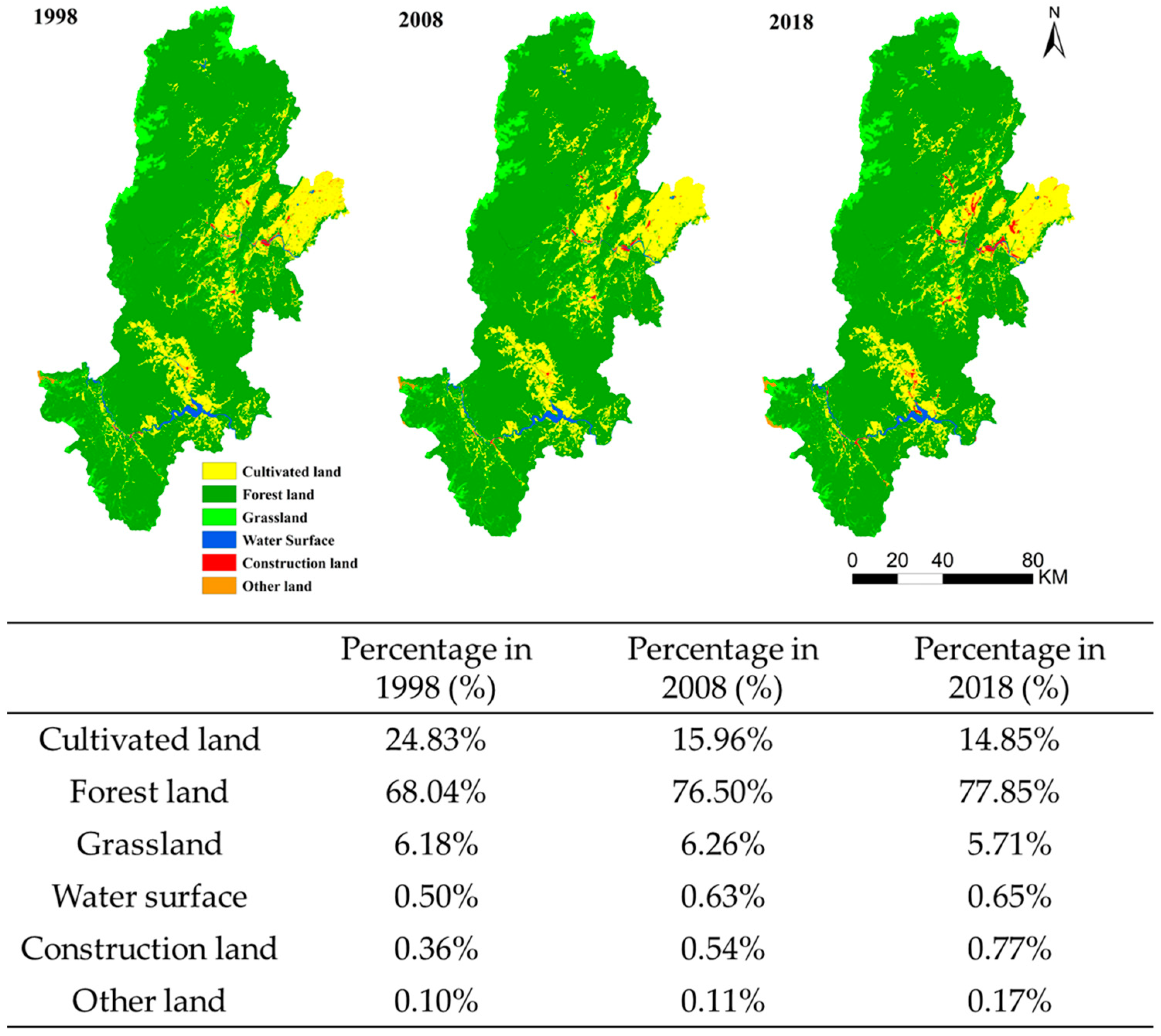
2.1. Study Area
2.2. Data Preparation
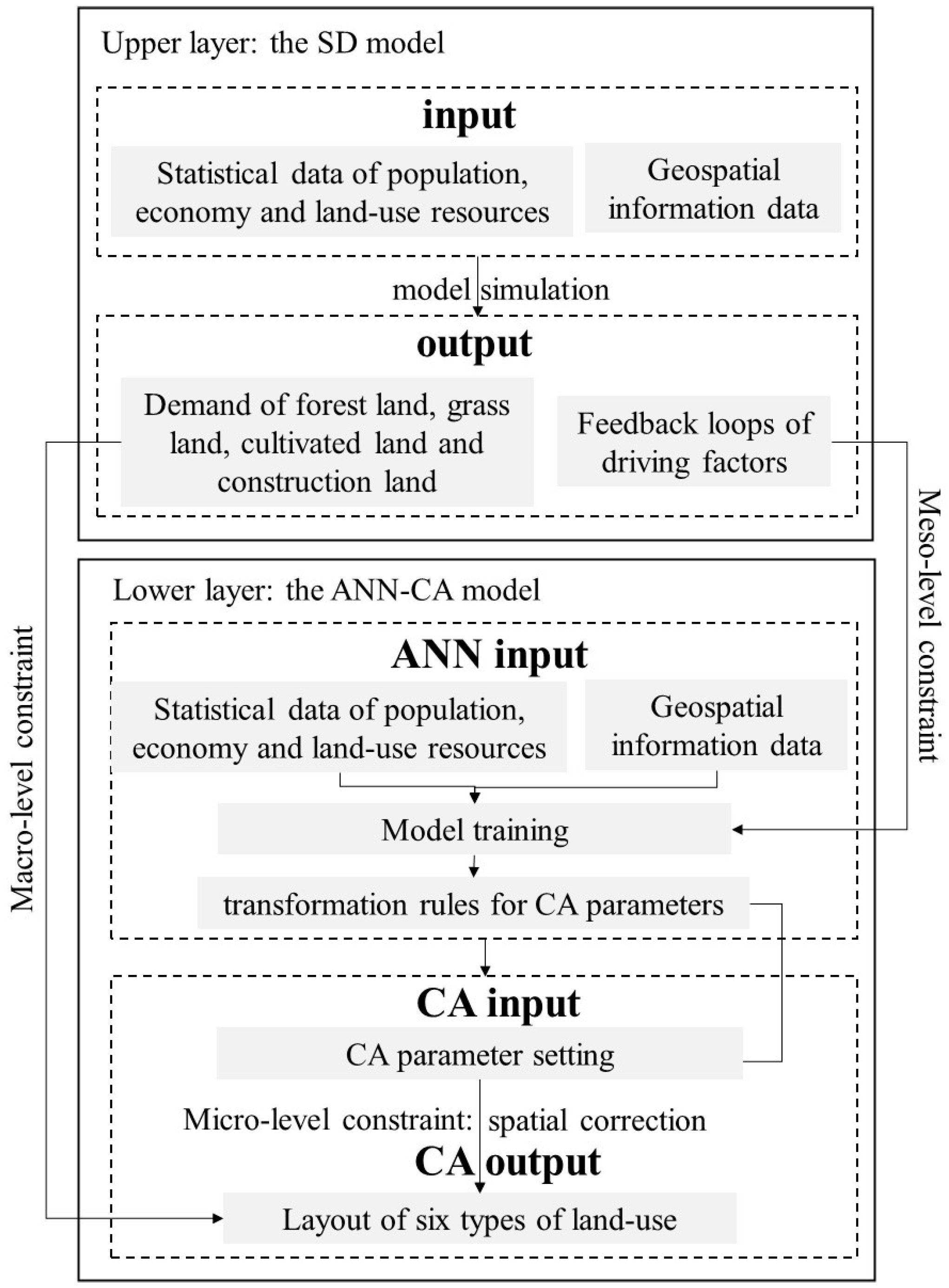
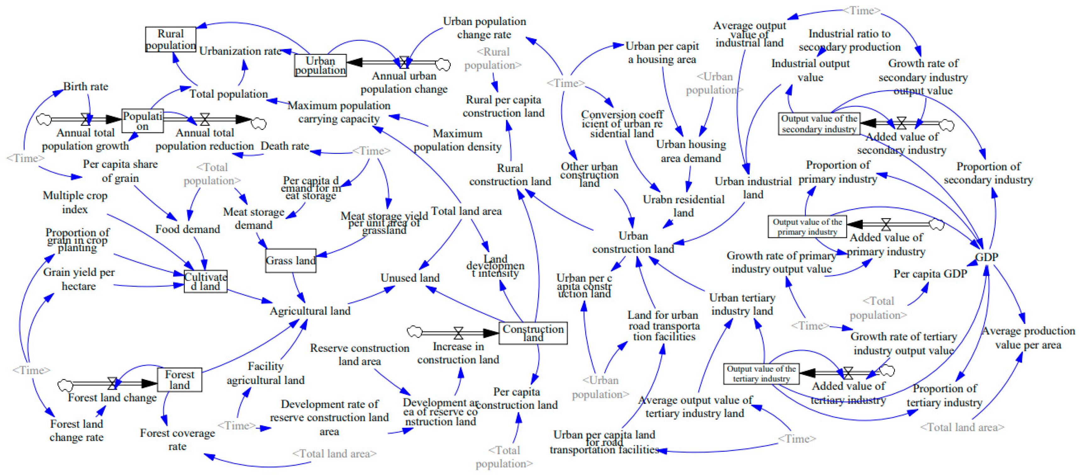
2.3. A Two-Layer SD-ANN-CA Model Framework Construction
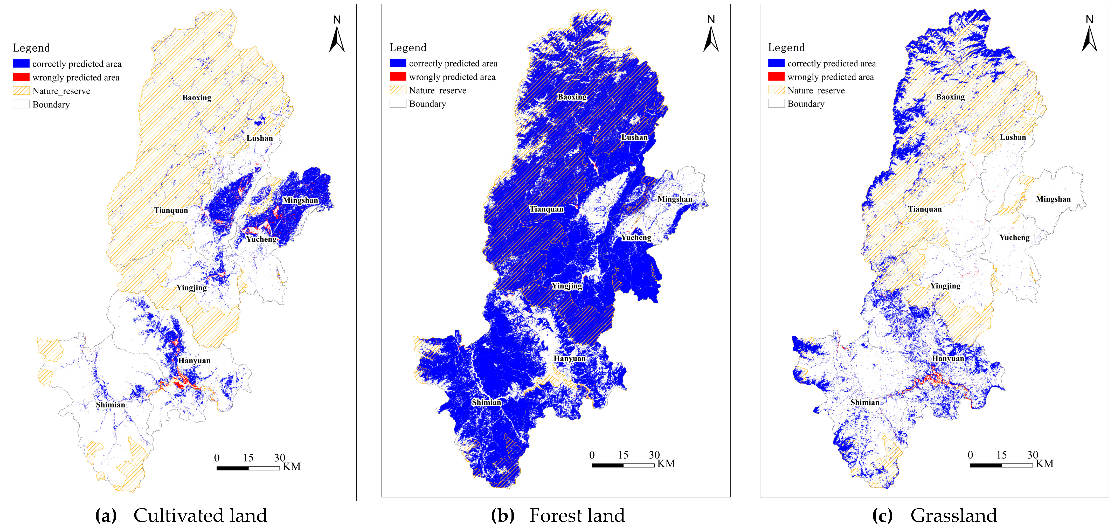
2.4. Estimation of Simulation Accuracy
- -
- Overall Error-accuracy (OA)
- -
- The kappa coefficient
2.5. Selection of Key Driving Factors
3. Results
3.1. Simulation and Results of the SD Model Layer
3.1.1. Identification of Meso-Level Feedback Constraints
3.1.2. Identification of Macro-Level Demand Constraint
3.2. Simulation of the ANN-CA Model Layer under Constraints
3.2.1. Artificial Neural Network Training under Meso-Level Constraints
3.2.2. Setting of CA Parameters Following ANN Rules and Spatial Constraints
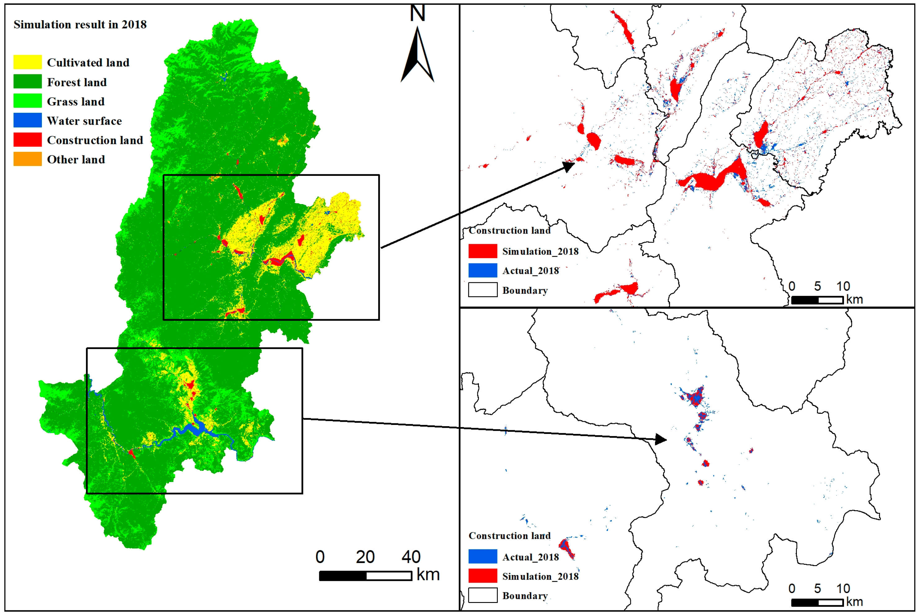
3.3. Output Simulation Results under Macro-Level Demand Constraints
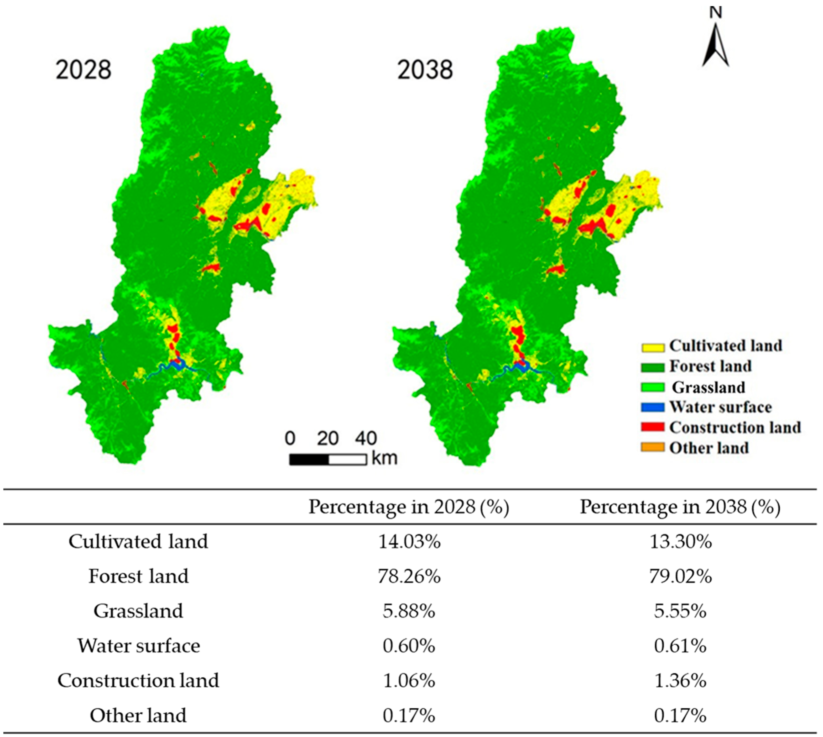
3.4. Land Use Prediction for the Years 2028 and 2038 in the Study Area
4. Discussion
5. Conclusions
Author Contributions
Funding
Data Availability Statement
Acknowledgments
Conflicts of Interest
References
- Olofsson, P.; Foody, G.M.; Stehman, S.V.; Woodcock, C.E. Making Better Use of Accuracy Data in Land Change Studies: Estimating Accuracy and Area and Quantifying Uncertainty Using Stratified Estimation. Remote Sens. Environ. 2013, 129, 122–131. [Google Scholar] [CrossRef]
- Meyfroidt, P.; Roy Chowdhury, R.; de Bremond, A.; Ellis, E.C.; Erb, K.-H.; Filatova, T.; Garrett, R.D.; Grove, J.M.; Heinimann, A.; Kuemmerle, T.; et al. Middle-Range Theories of Land System Change. Glob. Environ. Chang. 2018, 53, 52–67. [Google Scholar] [CrossRef]
- Liu, X.; Liang, X.; Li, X.; Xu, X.; Ou, J.; Chen, Y.; Li, S.; Wang, S.; Pei, F. A Future Land Use Simulation Model (FLUS) for Simulating Multiple Land Use Scenarios by Coupling Human and Natural Effects. Landsc. Urban Plan. 2017, 168, 94–116. [Google Scholar] [CrossRef]
- Wang, J.; Bretz, M.; Dewan, M.A.A.; Delavar, M.A. Machine Learning in Modelling Land-Use and Land Cover-Change (LULCC): Current Status, Challenges and Prospects. Sci. Total Environ. 2022, 822, 153559. [Google Scholar] [CrossRef]
- Verburg, P.H.; van de Steeg, J.; Veldkamp, A.; Willemen, L. From Land Cover Change to Land Function Dynamics: A Major Challenge to Improve Land Characterization. J. Environ. Manag. 2009, 90, 1327–1335. [Google Scholar] [CrossRef] [PubMed]
- Park, J.-Y.; Park, M.-J.; Joh, H.-K.; Shin, H.-J.; Kwon, H.-J.; Srinivasan, R.; Kim, S.-J. Assessment of MIROC3.2 hires Climate and CLUE-s Land Use Change Impacts on Watershed Hydrology Using SWAT. Trans. ASABE 2011, 54, 1713–1724. [Google Scholar] [CrossRef]
- Letourneau, A.; Verburg, P.H.; Stehfest, E. A Land-Use Systems Approach to Represent Land-Use Dynamics at Continental and Global Scales. Environ. Model. Softw. 2012, 33, 61–79. [Google Scholar] [CrossRef]
- Deng, X. Modeling the Dynamics and Consequences of Land System Change; Springer: Berlin/Heidelberg, Germany, 2011. [Google Scholar]
- Zhao, J.S.; Yuan, L.; Zhang, M. A Study of the System Dynamics Coupling Model of the Driving Factors for Multi-Scale Land Use Change. Environ. Earth Sci. 2016, 75, 529. [Google Scholar] [CrossRef]
- Qian, Y.; Xing, W.; Guan, X.; Yang, T.; Wu, H. Coupling Cellular Automata with Area Partitioning and Spatiotemporal Convolution for Dynamic Land Use Change Simulation. Sci. Total Environ. 2020, 722, 137738. [Google Scholar] [CrossRef]
- White, R.; Engelen, G. Urban Systems Dynamics and Cellular Automata: Fractal Structures between Order and Chaos. Chaos Solitons Fractals 1994, 4, 563–583. [Google Scholar] [CrossRef]
- Lee, S.-T.; Wu, C.-W.; Lei, T.-C. CA-GIS Model for Dynamic Simulation of Commercial Activity Development by the Combination of ANN and Bayesian Probability. Procedia Comput. Sci. 2013, 18, 651–660. [Google Scholar] [CrossRef]
- Liu, X.; Hu, G.; Ai, B.; Li, X.; Tian, G.; Chen, Y.; Li, S. Simulating Urban Dynamics in China Using a Gradient Cellular Automata Model Based on S-Shaped Curve Evolution Characteristics. Int. J. Geogr. Inf. Sci. 2017, 32, 73–101. [Google Scholar] [CrossRef]
- Kim, Y.; Newman, G.; Güneralp, B. A Review of Driving Factors, Scenarios, and Topics in Urban Land Change Models. Land 2020, 9, 246. [Google Scholar] [CrossRef] [PubMed]
- Li, K.; Feng, M.; Biswas, A.; Su, H.; Niu, Y.; Cao, J. Driving Factors and Future Prediction of Land Use and Cover Change Based on Satellite Remote Sensing Data by the LCM Model: A Case Study from Gansu Province, China. Sensors 2020, 20, 2757. [Google Scholar] [CrossRef] [PubMed]
- Dewan, A.M.; Yamaguchi, Y. Land Use and Land Cover Change in Greater Dhaka, Bangladesh: Using Remote Sensing to Promote Sustainable Urbanization. Appl. Geogr. 2009, 29, 390–401. [Google Scholar] [CrossRef]
- Mansour, S.; Al-Belushi, M.; Al-Awadhi, T. Monitoring Land Use and Land Cover Changes in the Mountainous Cities of Oman Using GIS and CA-Markov Modelling Techniques. Land Use Policy 2020, 91, 104414. [Google Scholar] [CrossRef]
- Fang, Z.; Ding, T.; Chen, J.; Xue, S.; Zhou, Q.; Wang, Y.; Wang, Y.; Huang, Z.; Yang, S. Impacts of Land Use/Land Cover Changes on Ecosystem Services in Ecologically Fragile Regions. Sci. Total Environ. 2022, 831, 154967. [Google Scholar] [CrossRef] [PubMed]
- Ning, C.; Subedi, R.; Hao, L. Land Use/Cover Change, Fragmentation, and Driving Factors in Nepal in the Last 25 Years. Sustainability 2023, 15, 6957. [Google Scholar] [CrossRef]
- Munteanu, C.; Kuemmerle, T.; Boltiziar, M.; Butsic, V.; Gimmi, U.; Halada, L.; Kaim, D.; Király, G.; Konkoly-Gyuró, É.; Kozak, J.; et al. Forest and Agricultural Land Change in the Carpathian Region—A Meta-Analysis of Long-Term Patterns and Drivers of Change. Land Use Policy 2014, 38, 685–697. [Google Scholar] [CrossRef]
- Wang, R.; Derdouri, A.; Murayama, Y. Spatiotemporal Simulation of Future Land Use/Cover Change Scenarios in the Tokyo Metropolitan Area. Sustainability 2018, 10, 2056. [Google Scholar] [CrossRef]
- Plieninger, T.; Draux, H.; Fagerholm, N.; Bieling, C.; Bürgi, M.; Kizos, T.; Kuemmerle, T.; Primdahl, J.; Verburg, P.H. The Driving Forces of Landscape Change in Europe: A Systematic Review of the Evidence. Land Use Policy 2016, 57, 204–214. [Google Scholar] [CrossRef]
- Güneralp, B.; Reilly, M.K.; Seto, K.C. Capturing Multiscalar Feedbacks in Urban Land Change: A Coupled System Dynamics Spatial Logistic Approach. Environ. Plan. B Plan. Des. 2012, 39, 858–879. [Google Scholar] [CrossRef]
- Yi, W.; Gao, Z.; Chen, M. Dynamic Modelling of Future Land-Use Change: A Comparison between CLUE-S and Dinamica EGO Models. In Proceedings of the SPIE Proceedings, San Diego, CA, USA, 24 October 2012. [Google Scholar]
- Ulloa-Espíndola, R.; Martín-Fernández, S. Simulation and Analysis of Land Use Changes Applying Cellular Automata in the South of Quito and the Machachi Valley, Province of Pichincha, Ecuador. Sustainability 2021, 13, 9525. [Google Scholar] [CrossRef]
- Li, X.; Yeh, A.G.-O. Neural-Network-Based Cellular Automata for Simulating Multiple Land Use Changes Using GIS. Int. J. Geogr. Inf. Sci. 2002, 16, 323–343. [Google Scholar] [CrossRef]
- Liu, X.; Li, X.; Liu, L.; He, J.; Ai, B. A Bottom-up Approach to Discover Transition Rules of Cellular Automata Using Ant Intelligence. Int. J. Geogr. Inf. Sci. 2008, 22, 1247–1269. [Google Scholar] [CrossRef]
- Liu, X.; Ou, J.; Li, X.; Ai, B. Combining System Dynamics and Hybrid Particle Swarm Optimization for Land Use Allocation. Ecol. Model. 2013, 257, 11–24. [Google Scholar] [CrossRef]
- Zhang, Y.; Li, X.; Liu, X.; Qiao, J. Self-Modifying CA Model Using Dual Ensemble Kalman Filter for Simulating Urban Land-Use Changes. Int. J. Geogr. Inf. Sci. 2015, 29, 1612–1631. [Google Scholar] [CrossRef]
- Alqurashi, A.; Kumar, L.; Sinha, P. Urban Land Cover Change Modelling Using Time-Series Satellite Images: A Case Study of Urban Growth in Five Cities of Saudi Arabia. Remote Sens. 2016, 8, 838. [Google Scholar] [CrossRef]
- Varga, O.G.; Pontius Jr, R.G.; Szabó, Z.; Szabó, S. Effects of Category Aggregation on Land Change Simulation Based on Corine Land Cover Data. Remote Sens. 2020, 12, 1314. [Google Scholar] [CrossRef]
- da Cunha, E.R.; Santos, C.A.G.; da Silva, R.M.; Bacani, V.M.; Pott, A. Future Scenarios Based on a CA-Markov Land Use and Land Cover Simulation Model for a Tropical Humid Basin in the Cerrado/Atlantic Forest Ecotone of Brazil. Land Use Policy 2021, 101, 105141. [Google Scholar] [CrossRef]
- Nath, N.; Sahariah, D.; Meraj, G.; Debnath, J.; Kumar, P.; Lahon, D.; Chand, K.; Farooq, M.; Chandan, P.; Singh, S.K.; et al. Land Use and Land Cover Change Monitoring and Prediction of a UNESCO World Heritage Site: Kaziranga Eco-Sensitive Zone Using Cellular Automata-Markov Model. Land 2023, 12, 151. [Google Scholar] [CrossRef]
- Beroho, M.; Briak, H.; Cherif, E.K.; Boulahfa, I.; Ouallali, A.; Mrabet, R.; Kebede, F.; Bernardino, A.; Aboumaria, K. Future Scenarios of Land Use/Land Cover (LULC) Based on a CA-Markov Simulation Model: Case of a Mediterranean Watershed in Morocco. Remote Sens. 2023, 15, 1162. [Google Scholar] [CrossRef]
- Zhu, X.X.; Tuia, D.; Mou, L.; Xia, G.-S.; Zhang, L.; Xu, F.; Fraundorfer, F. Deep Learning in Remote Sensing: A Comprehensive Review and List of Resources. IEEE Geosci. Remote Sens. Mag. 2017, 5, 8–36. [Google Scholar] [CrossRef]
- Talukdar, S.; Singha, P.; Mahato, S.; Shahfahad; Pal, S.; Liou, Y.-A.; Rahman, A. Land-Use Land-Cover Classification by Machine Learning Classifiers for Satellite Observations—A Review. Remote Sens. 2020, 12, 1135. [Google Scholar] [CrossRef]
- Zhan, X.; Yu, S. Reconstructing the Historical Patterns of Forest Stand Based on CA-adaboost-ANN Model. For. Ecol. Manag. 2020, 478, 118518. [Google Scholar] [CrossRef]
- Šetka, J.; Radeljak Kaufmann, P.; Valožić, L. Modelling Land Use and Land Cover Changes in the Lower Neretva Region. Hrvat. Geogr. Glas. /Croat. Geogr. Bull. 2023, 85, 41–63. [Google Scholar] [CrossRef]
- Gharaibeh, A.; Shaamala, A.; Obeidat, R.; Al-Kofahi, S. Improving Land-Use Change Modeling by Integrating ANN with Cellular Automata-Markov Chain Model. Heliyon 2020, 6, e05092. [Google Scholar] [CrossRef] [PubMed]
- Lukas, P.; Melesse, A.M.; Kenea, T.T. Prediction of Future Land Use/Land Cover Changes Using a Coupled CA-ANN Model in the Upper Omo–Gibe River Basin, Ethiopia. Remote Sens. 2023, 15, 1148. [Google Scholar] [CrossRef]
- Available online: https://dl.acm.org/doi/abs/10.5555/2331751.2331752 (accessed on 23 September 2023).
- Liu, J.; Hu, C.; Kang, X.; Chen, F. A Loosely Coupled Model for Simulating and Predicting Land Use Changes. Land 2023, 12, 189. [Google Scholar] [CrossRef]
- Verburg, P.H.; Soepboer, W.; Veldkamp, A.; Limpiada, R.; Espaldon, V.; Mastura, S.S.A. Modeling the Spatial Dynamics of Regional Land Use: The CLUE-S Model. Environ. Manag. 2002, 30, 391–405. [Google Scholar] [CrossRef]
- Kucsicsa, G.; Popovici, E.-A.; Bălteanu, D.; Grigorescu, I.; Dumitraşcu, M.; Mitrică, B. Future Land Use/Cover Changes in Romania: Regional Simulations Based on CLUE-S Model and CORINE Land Cover Database. Landsc. Ecol. Eng. 2018, 15, 75–90. [Google Scholar] [CrossRef]
- Li, Y.; Liu, X.; Wang, Y.; He, Z. Simulating Multiple Scenarios of Land Use/Cover Change Using a Coupled Model to Capture Ecological and Economic Effects. Land Degrad. Dev. 2023, 34, 2862–2879. [Google Scholar] [CrossRef]
- Çağlıyan, A.; Dağlı, D. Monitoring Land Use Land Cover Changes and Modelling of Urban Growth Using a Future Land Use Simulation Model (FLUS) in Diyarbakır, Turkey. Sustainability 2022, 14, 9180. [Google Scholar] [CrossRef]
- Huang, K.; Liu, X.; Li, X.; Liang, J.; He, S. An Improved Artificial Immune System for Seeking the Pareto Front of Land-Use Allocation Problem in Large Areas. Int. J. Geogr. Inf. Sci. 2013, 27, 922–946. [Google Scholar] [CrossRef]
- Xu, Q.; Wang, Q.; Liu, J.; Liang, H. Simulation of Land-Use Changes Using the Partitioned ANN-CA Model and Considering the Influence of Land-Use Change Frequency. ISPRS Int. J. Geo-Inf. 2021, 10, 346. [Google Scholar] [CrossRef]
- Zhao, J.; Zhu, X.; Zhou, Y.; Guo, K.; Huang, Y. Examining Land-Use Change Trends in Yucheng District, Ya’an City, China, Using ANN-CA Modeling. J. Urban Plan. Dev. 2023, 149, 1–9. [Google Scholar] [CrossRef]
- Zhao, J.; Zhou, Y.; Zhu, X.; Zhang, F.; Gao, L. ANN-CA Model Construction under SD Constraint: A Case Study on the Land-Use Change Trend in Ya’an City. Available online: https://www.researchsquare.com/article/rs-3634077/v1 (accessed on 23 September 2023).
- Geospatial Data Cloud. Available online: http://www.gscloud.cn/search (accessed on 23 September 2023).
- OpenStreetMap. Available online: https://www.openstreetmap.org/ (accessed on 23 September 2023).
- The World Database on Protected Areas. Available online: https://www.protectedplanet.net/en (accessed on 23 September 2023).
- Bigemap. Available online: http://www.bigemap.com/ (accessed on 23 September 2023).
- Ya’an Municipal People’s Government. (2008–2018). Statistical Yearbook of Ya’an City. Available online: https://www.yaan.gov.cn/gongkai/kuozhan/10393.html (accessed on 23 September 2023). (In Chinese)
- The People’s Government of Sichuan Province. (2000–2018). Statistical Yearbook of Sichuan Province. Available online: https://tjj.sc.gov.cn/scstjj/c105855/nj.shtml (accessed on 23 September 2023). (In Chinese)
- Ministry of Natural Resources of the People ‘s Republic of China. (2001–2016). China National Land and Resources Statistical Yearbook. Available online: https://www.mnr.gov.cn/sj/tjgb/ (accessed on 23 September 2023). (In Chinese)
- Ministry of Housing and Urban-Rural Development of the People’s Republic of China. (2000–2016). China Urban Construction Statistical Yearbook. Available online: https://www.mohurd.gov.cn/gongkai/fdzdgknr/sjfb/tjxx/tjgb/index.html (accessed on 23 September 2023). (In Chinese)
- Li, X.; Wang, Y.; Li, J.; Lei, B. Physical and Socioeconomic Driving Forces of Land-Use and Land-Cover Changes: A Case Study of Wuhan City, China. Discret. Dyn. Nat. Soc. 2016, 2016, 8061069. [Google Scholar] [CrossRef]
- Guan, D.; Zhao, Z.; Tan, J. Dynamic Simulation of Land Use Change Based on Logistic-CA-Markov and WLC-CA-Markov Models: A Case Study in Three Gorges Reservoir Area of Chongqing, China. Environ. Sci. Pollut. Res. 2019, 26, 20669–20688. [Google Scholar] [CrossRef]


| Type | Data | Time | Description | Source | Format/Resolution |
|---|---|---|---|---|---|
| Geospatial information data | Remote sensing images | 1998 2008 2018 | Three phases of graphic data regarding land use status through interpretation of remote sensing images. | Geospatial data cloud (http://www.gscloud.cn/search) [51] | Raster, 30 m |
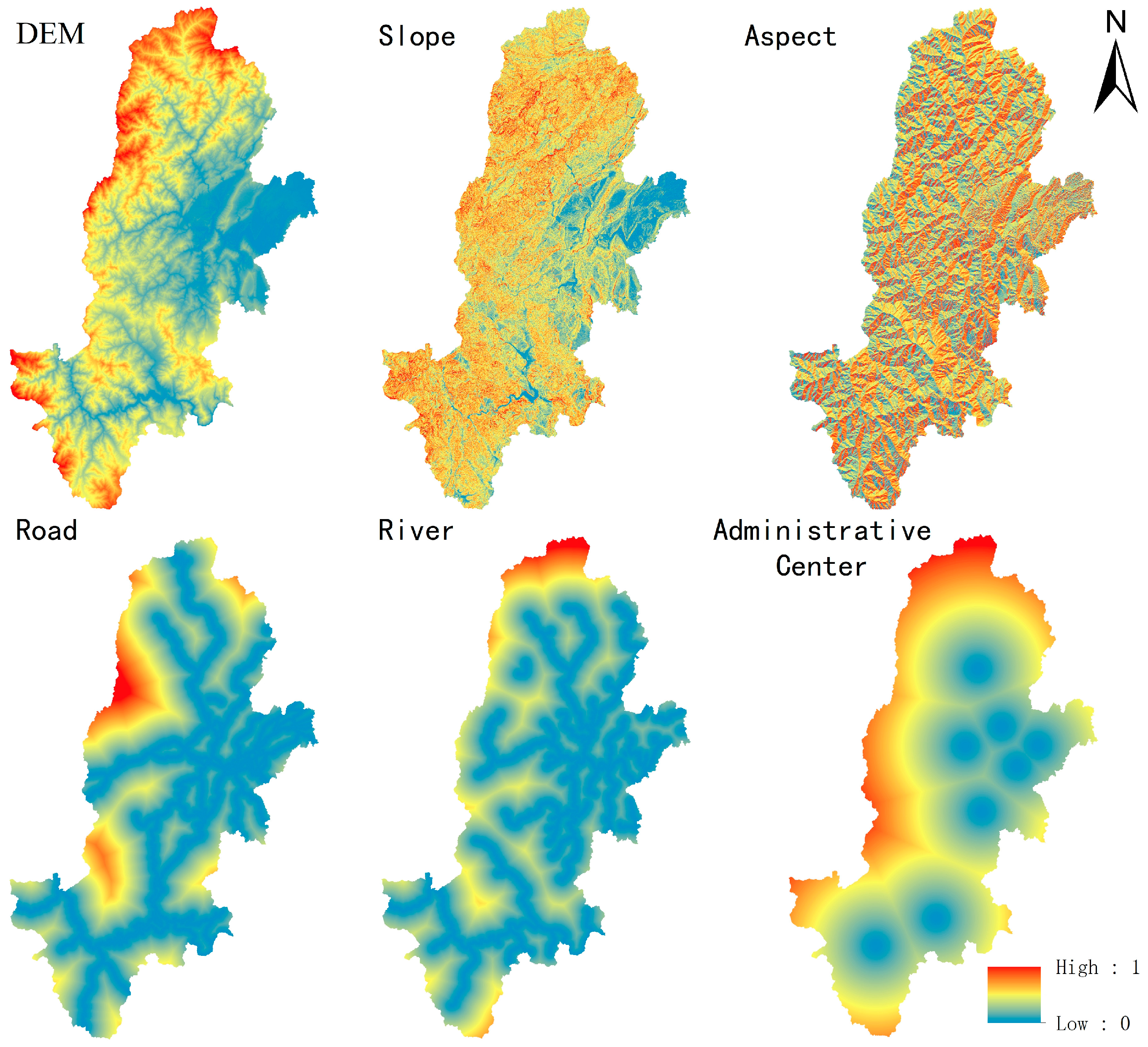
| DEM | 2018 | Slope and aspect were acquired through the 3D analysis of DEM, which are used as the model’s constraints. | Geospatial data cloud (http://www.gscloud.cn/search) [51] | Raster, 30 m | |
| Road map | 2020 | The arterial road map was acquired as a constraint of the model. | Open Street Map (https://www.openstreetmap.org/) [52] | Shapefile (line) | |
| River chart | 2020 | The major river chart was acquired as a constraint of the model. | Open Street Map (https://www.openstreetmap.org/) [52] | Shapefile (line) | |
| Residential areas | 2020 | Major cities and towns were acquired as rated constraints of the model. | Open Street Map (https://www.openstreetmap.org/) [52] | Shapefile (point) | |
| Natural reserve | 2020 | Used as the constraint of the model. | The World Database on Protected Areas (WDPA) [53] | Shapefile (polygon) | |
| Administrative map | 2020 | Running boundary of the model. | BIGEMAP software ver. 30.0.9.14 [54] | Shapefile (polygon) | |
| Numerical data | Population data | 1998–2018 | Input data of the SD model. Include information on urban and rural population numbers, change rates, and carrying capacities. | Statistical Yearbook of Ya’an City [55] Statistical Yearbook of Sichuan Province [56] | |
| Industrial output value | 1998–2018 | Input data of the SD model. Encompass the value-added of primary, secondary, and tertiary industries along with their growth rates, as well as land value-added information | Statistical Yearbook of Ya’an City [55] Statistical Yearbook of Sichuan Province [56] | ||
| Agricultural and grain data | 1998–2018 | Input data of the SD model. Comprise production quantities, per capita consumption levels, and demand figures for grains and livestock meat products. | Statistical Yearbook of Ya’an City [55] Statistical Yearbook of Sichuan Province [56] | ||
| Housing and construction information | 1998–2018 | Input data of the SD model. Contain urbanization rates, housing areas, housing demands, land usage areas, etc. | China National Land and Resources Statistical Yearbook [57] China Urban Construction Statistical Yearbook [58] |
| Classification of Driving Factors | Number of Variables Considered | Variable Names |
|---|---|---|
| Socioeconomic factors | 69 |
|
| Spatial factors | 6 | Elevation, slope, aspect, distance to main roads, distance to rivers, and distance to administrative centers |
| Output Variables | The Year 2018 | The Year 2028 | The Year 2038 |
|---|---|---|---|
| Area of forest land (ha) | 537,953 | 570,353 | 603,948 |
| Area of grassland (ha) | 40,279 | 39,382 | 39,699 |
| Area of cultivated land (ha) | 55,090 | 50,661 | 51,809 |
| Area of construction land (ha) | 11,447 | 16,488 | 22,806 |
| Cultivated Land | Forest Land | Grassland | Water Surface | Construction Land | Other Land | |
|---|---|---|---|---|---|---|
| Cultivated land | 1 | 1 | 1 | 1 | 1 | 0 |
| Forest land | 1 | 1 | 1 | 1 | 1 | 1 |
| Grassland | 1 | 1 | 1 | 1 | 1 | 1 |
| Water surface | 0 | 0 | 0 | 1 | 1 | 0 |
| Construction land | 0 | 0 | 0 | 0 | 1 | 0 |
| Other land | 0 | 0 | 0 | 0 | 0 | 1 |
| Cultivated Land | Forest Land | Grassland | Water Surface | Construction Land | Other Land | |
|---|---|---|---|---|---|---|
| Actual number of cells | 185,868 | 1,403,516 | 233,992 | 11,520 | 18,986 | 3159 |
| Simulation number of cells SD-ANN-CA model (ha) | 190,987 | 1,404,623 | 234,522 | 10,934 | 18,951 | 3145 |
| Error-accuracy of SD-ANN-CA model | 2.75% | 0.08% | 0.23% | 5.08% | 0.18% | 0.44% |
| Kappa coefficient of SD-ANN-CA model | 0.931 | 0.998 | 0.994 | 0.873 | 0.996 | 0.989 |
| Error-accuracy of ANN-CA model [49] | 3.25% | 3.57% | 4.35% | 7.34% | 3.78% | 5.56% |
Disclaimer/Publisher’s Note: The statements, opinions and data contained in all publications are solely those of the individual author(s) and contributor(s) and not of MDPI and/or the editor(s). MDPI and/or the editor(s) disclaim responsibility for any injury to people or property resulting from any ideas, methods, instructions or products referred to in the content. |
© 2024 by the authors. Licensee MDPI, Basel, Switzerland. This article is an open access article distributed under the terms and conditions of the Creative Commons Attribution (CC BY) license (https://creativecommons.org/licenses/by/4.0/).
Share and Cite
Zhao, J.; Zhu, X.; Zhang, F.; Gao, L. A Two-Layer SD-ANN-CA Model Framework for Multi-Typed Land Use and Land Cover Change Prediction under Constraints: Case Study of Ya’an City Area, Western China. Land 2024, 13, 714. https://doi.org/10.3390/land13050714
Zhao J, Zhu X, Zhang F, Gao L. A Two-Layer SD-ANN-CA Model Framework for Multi-Typed Land Use and Land Cover Change Prediction under Constraints: Case Study of Ya’an City Area, Western China. Land. 2024; 13(5):714. https://doi.org/10.3390/land13050714
Chicago/Turabian StyleZhao, Jingyao, Xiaofan Zhu, Fan Zhang, and Lei Gao. 2024. "A Two-Layer SD-ANN-CA Model Framework for Multi-Typed Land Use and Land Cover Change Prediction under Constraints: Case Study of Ya’an City Area, Western China" Land 13, no. 5: 714. https://doi.org/10.3390/land13050714
APA StyleZhao, J., Zhu, X., Zhang, F., & Gao, L. (2024). A Two-Layer SD-ANN-CA Model Framework for Multi-Typed Land Use and Land Cover Change Prediction under Constraints: Case Study of Ya’an City Area, Western China. Land, 13(5), 714. https://doi.org/10.3390/land13050714