Abstract
Planning a well-structured urban green infrastructure (UGI) is essential for cities to counteract the impacts of climate change. Soil carbon and air temperature differences between open and plant-covered sites were used as proxies of carbon sequestration (CS) and temperature regulation (TR) to evaluate the current conditions of UGI in Zaragoza, a medium-sized city in northeastern Spain. Alternative scenarios were constructed, after a stakeholder consultation, at both city and municipal (city plus peri-urban zone) scales, extrapolating the highest values of CS and TR to two groups of UGI types grouped based on the state of their ecological functioning. We employed analysis of variance to compare mean values of CS and TR across diverse scenarios at both city and municipality scales. Statistically significant differences were found in city-scale and municipality-scale scenarios for both CS and TR. Multiplying CS by area did not show significant variation in city scale. Significant differences were found when multiplying TR by area at both scales, with exceptions in certain scenario combinations. These results suggest favoring the restoration of UGI sites in peri-urban zones (such as forests and steppe zones) to increase CS and those in densely urbanized zones (such as urban parks) to provide TR benefits.
1. Introduction
More than half of the world’s population today lives in cities, and the urban population of the world is expected to continue growing so that by 2050, 66% of the world’s almost 10 billion inhabitants will be urban dwellers [1]. Evidence provided by scientists showed that this rapid urbanization, a major contributor to climate change [2], significantly contributed to deteriorating urban residents’ thermal comfort [3]. The worldwide rising of temperatures causes ocean levels to rise, increases the number of extraordinary climate events such as surges, dry seasons, and storms [4], and increases the spread of tropical illnesses [5]. All these have exorbitant impacts on cities’ essential services, infrastructure, lodging, jobs, and well-being [6]. Therefore, humans are still dependent on nature for their livelihood [7]. The numerous environmental and social advantages of integrating natural areas into urban and heavily populated areas are becoming more widely acknowledged [8].
Urban green infrastructure (UGI) is a term used to describe systems that incorporate natural elements into the design of a built space, and it includes both green and blue ecosystems [9]. UGI is an essential structural part of cities [10], and all around the world, the creation of a UGI is acknowledged as a crucial instrument in combating climate change [11,12]. UGI is also a useful method for spatial planning in a number of national, regional, and local planning, policy documents, and strategies [13]. For instance, the European Green Belt and the European Green Infrastructure Strategy are good examples [14]. UGI provides benefits that play a key role in climate change adaptation, specifically decreasing the urban heat island effect [15]. These benefits are called ecosystem services (ES), essential for human well-being [16]. ES were classified by the MEA [16] into four groups: supporting services (e.g., soil formation) [17], provisioning services (e.g., food production) [18], cultural services (e.g., spiritual and religious values) [19], and regulating services (e.g., carbon sequestration and temperature regulation) [15,16].
Carbon sequestration is the process of capturing and storing atmospheric carbon dioxide and fixing it in terrestrial structures [20]. It is one method of reducing the amount of carbon dioxide in the atmosphere with the goal of reducing the influence of greenhouse gases on global warming by reducing their increase in the atmosphere [21]. Even though, in 2019, the European Green Deal set an objective to make the EU climate neutral by 2050, few peer-reviewed articles acknowledge local case studies about carbon sequestration in intermediate cities [22]. Temperature regulation is essential in the fight against the impact of heat waves in urban areas. An efficient mitigation of this impact involves introducing different UGI elements in urbanized zones, such as urban parks, urban forests, rooftops, gardened squares, and roundabouts that can play the role of climate cooling shelters [23]. As was demonstrated, these UGI sites should have a high degree of naturalness and functioning and less regularity in their design [9].
Scenario analysis plays a pivotal role in understanding the implications of design choices within UGI for the protection and restoration of ES delivery [24], which has been the subject of constant discussion since the release of the Millennium Ecosystem Assessment [25]. Three processes typically make up a scenario analysis: (1) defining the scope, (2) creating alternative scenarios, and (3) evaluating those scenarios [26]. Scenario analysis has grown in popularity as a method for researching future ecosystems, technologies, societies, climates, and other aspects of the future [27], but it still remains in its early development stages, hence the need for more investigation in this field [24]. It is agreed that scenarios are alternative views of the future that result from a certain set of assumptions and relationships rather than forecasts, projections, or predictions [28]. Through the examination of contrasting scenarios, decision-makers can evaluate various options, recognize possible disadvantages, prioritize areas for restoration, and foresee opportunities, thus facilitating the development of more knowledgeable and robust strategies for UGI planning. This way, one can straightforwardly observe how different scenarios affect the provision of ES [29]. Hence, stakeholder involvement and data-driven analysis are necessary to guarantee that scenario analysis for the provision of ES is reliable and helpful for making decisions [30]. However, research has shown that there is a lack of stakeholder involvement that can represent diverse values [24].
In this paper, we apply these perspectives to the city of Zaragoza, an intermediate-size urban zone in Southern Europe, and its municipality in order to develop a prioritization plan for the improvement of its UGI to counteract the impacts of climate change. The objectives of this paper are to (1) define different scenarios of UGI based on a survey distributed among a range of expert stakeholders, (2) apply the evaluation of ES in different scenarios of UGI within two scales: city and municipality, and (3) analyze the contrasting provision of ES between alternative scenarios of UGI. After this, a prioritization plan based on the potential provision of ES by UGI is proposed. Zaragoza can be a paradigm for other intermediate-size urban zones as it is located in an extremely sensitive location to increased air temperature as a consequence of climate change [31]. We hypothesize that in order to fight against climate change in this type of city, there is a need to work on ES provided by UGI not only on the city scale, where urbanization is high and possibilities of UGI improvement are limited, but also at the municipality scale, where large non-built zones dominate the land cover.
2. Materials and Methods
The protocol for scenario analysis comprises three stages (Figure 1). The first stage of the research consisted of data preparation, which involved ES selection, expert interviews, and data collection. The second stage consisted of scenario development. It included constructing the narrative, designing the scenario, and quantifying the ES times area (ES × Area) of the UGI element for each scenario based on the data gathered from the first stage. Finally, a prioritization strategy was developed and presented in the discussion section that could be useful for decision-makers to enhance climate adaptation in cities (Figure 1).
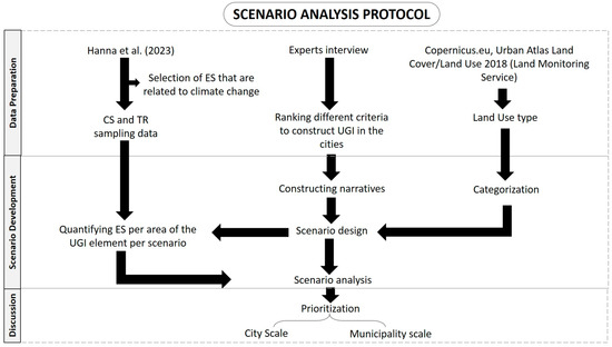
Figure 1.
Methodology describing the steps used for the scenario analysis. Ecosystem services (ES), carbon sequestration (CS), temperature regulation (TR), and urban green infrastructure (UGI). Hanna et al. (2023) [9]. Copernicus: https://land.copernicus.eu/ (accessed on 1 October 2023).
2.1. Data Preparation
2.1.1. Study Area and UGI Types
The study area is the city of Zaragoza and its municipality, which is a European medium-sized urban zone with a population of 693,000, a city area of 167 km2, and a municipality area of 967 km2. It is situated in the autonomous community of Aragon in northeastern Spain [32]. Zaragoza city lies in the center of the Ebro River Valley, and two tributaries (Gallego and Huerva Rivers) flow out in the Ebro River in the city of Zaragoza (199 m.a.s.l.). Additionally, a big canal carrying water diverted from the Ebro River to irrigate agricultural areas crosses through Zaragoza city. Downtown Zaragoza lies in the surroundings of these waterways, and the outskirts of Zaragoza are located in the upper parts of the old river terraces. More recently, Zaragoza city has been expanding beyond the river terraces throughout the steppe (299 m.a.s.l.), herbaceous, and dry agricultural zones, which conform to the landscape of most of its municipality (Figure 2a).
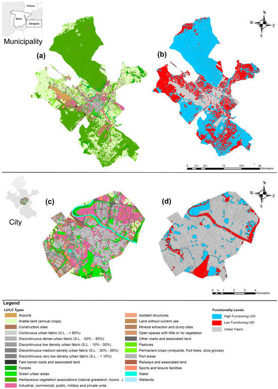
Figure 2.
(a) LU/LC map of the study area (Zaragoza) at municipality scale. (b) Functionality map of urban green infrastructure (UGI) sites of Zaragoza at municipality scale. (c) LU/LC map of the study area (Zaragoza) at city scale. (d) Functionality map of UGI of Zaragoza at city scale.
The natural, semi-natural, and artificial areas that comprise both terrestrial and aquatic ecosystems make up the UGI of Zaragoza. Some of them are tiny spots (urban parks and roundabouts) located in the most densely populated portion of the city. However, most of the comparatively large green spaces, such as riverbanks, forests, and meanders, are located in the peri-urban areas that surround the city. These areas cover a wide range of types of UGI sites and show a high variability of characteristics [9].
2.1.2. Land Use Categorization
The most recent (2018) land cover/land use (LULC) map of Zaragoza was downloaded from Copernicus.eu. We categorized these land use types into three groups based on their characteristics to facilitate a scenario analysis for improving existing UGI sites: (1) Group 1: These areas are already developed or under industrial use. They form the existing urban and industrial landscape and may not be suitable for extensive UGI development without significant transformation. (2) Group 2: This group includes areas that may have lower existing development intensity and have the potential for green improvement. These sites also have high naturalness and ecological functioning. They include pastures, forests, rivers, meanders, and herbaceous and steppe vegetation. (3) Group 3: This group consists of artificial and agricultural zones. They are characterized by low values of ecological functioning. However, they can have a high value of naturalness (e.g., urban parks, squares, and roundabouts) and are located inside the city, such as urban parks, roundabouts, cemeteries, and canals, or peri-urban areas such as agricultural land and arable land (annual cropland). These sites, even if characterized by low ecological functioning, can be crucial for UGI development, providing connectivity, temperature regulation, and enhancing climate change adaptation.
2.1.3. Naturalness and Functioning of UGI Sites
Naturalness is measured as the percentage of area covered by natural components within the UGI site, namely, naturalness = (% of the area with natural components)/10. Hence, naturalness values range from completely natural (10) to entirely artificial (0). For instance, a value of 9 means 90% of the total area of the UGI site is covered by natural components (vegetation). An analogous scale was established to assign values for functioning, which was defined as the degree of natural processes driving the dynamics of the UGI site based on the classical concept of ecosystem functioning. It was measured as the area of the UGI site observed with natural dynamic features (wind and water flows, flooding, erosion, and organic matter accumulation). Therefore, functioning = (% of the area with natural hydro-geomorphological features)/10. The values of functioning also ranged from 0 to 10, with 0 indicating non-functional sites highly influenced by humans and 10 pointing to the complete preservation of natural hydro-geomorphological features and processes. Further details on these two indexes are provided in previous work [33].
2.1.4. Stakeholders Engagement
To enhance decision-making regarding the type of scenario analysis, experts in the fields of urbanism, ecology, law, and politics (n = 7) received a semi-structured questionnaire (Appendix A) comprising questions to identify, rank, and rate a number of criteria to prioritize UGI, questions to improve current UGI sites for climate change adaptation, and questions to locate new UGI sites in the city of Zaragoza. The stakeholders were chosen for their dedication to sustainable urban development, which is evident in their involvement in public works, such as contributing to scientific publications and engaging in meetings with Zaragoza residents to gather their ideas and opinions on city development. The selection specifically targeted individuals associated with two organizations that bring together residents, environmental and non-governmental groups, and city officials responsible for managing urban green infrastructure.
2.1.5. Regulating Ecosystem Services
A recent study by Hanna et al. (2023) [9] evaluated and quantified the provision of 8 ESs in UGI sites of the study area (Figure 1). Within the ESs assessed, soil C content and the difference in air temperature between non-vegetated and vegetated zones were used as proxies for carbon sequestration and temperature regulation, which directly link to climate adaptation. Carbon sequestration (CS) is a regulating ES [34]. Soils are a significant carbon sink and have an important role in the fight against climate change [35]. CS values (g of Carbon/m2) were taken from Hanna et al. (2023) [9]. The methodology of sampling consisted of taking 3 soil samples, separated 20–200 m from each other, at a depth of 0–20 cm in the vegetated area of 30 UGI sites representing different elements of UGI in Zaragoza. Temperature regulation (TR) is also a regulating ES [36]. In the context of Urban Heat Island, TR in UGI sites is crucial for mitigating the impacts of climate change [37]. TR values (regulated Celsius/m2) were also derived from Hanna et al. (2023) [9]. Therein, the assessment of temperature regulation (TR) was performed using data loggers (iButton®) installed simultaneously in vegetated and non-vegetated zones and recorded hourly measurements for 1 month during the hot periods of the year (July–August 2022) to assess diurnal variations in air temperature.
2.2. Scenario Development
2.2.1. Scenario Design
The scenario design was performed on two scales: city and municipality. The city scale is represented by the densely populated area;, therefore, it has dense buildings of all types: residential, commercial, and industrial. The city is the central hub of the municipality of Zaragoza. Among the 231 UGI elements found in the city (canals, roundabouts, street trees, rivers, urban forests, university parks, urban natural parks, and green walls), urban parks dominate the landscape of the UGI’s artificially constructed sites. The municipality scale represented the peri-urban areas, where the anthropogenic intervention is smaller in comparison with the artificially constructed UGI elements in the city. Therefore, the municipality area covers the city area plus the peri-urban area. The UGI of peri-urban areas consisted of forests, pastures, arable land (annual crop agricultural land), permanent crop agricultural land, steppes (herbaceous mixed land), meander, and rivers. The total number of green infrastructure sites on the municipality scale is equal to 4902.
The scenario design reflected the criteria to plan and build spaces that form the green infrastructure of Zaragoza, which ranked highest among all stakeholders. High and low-functioning UGI sites were differentiated based on the ecological functioning assessment [10], ranking from the minimum 1 to the maximum 10. We created 8 scenarios, 4 for each scale.
City scale: (1) high functioning scenario (HF): current situation of sites with high value of functioning (>5/10) (river, urban natural park, and urban forests). (2) Low functioning scenario (LF): current situation of sites with low value of functioning (<5/10) (urban parks, canals, roundabouts, street trees, university park, and green walls). (3) Improving high functionality scenario (IMHF): improvement (or restoration) of sites with high value of functioning. (4) Improving low functioning scenario (IMLF): improvement (or restoration) of sites with low value of functioning.
Municipality scale: (1) HF = current situation of sites with high value of functioning (>5/10) (river, meander, steppe, forests, and pastures). (2) LF: current situation of sites with low value of functioning (<5/10) (arable land and permanent crops). (3) IMHF = improvement (or restoration) of sites with high value of functioning. (4) IMLF = improvement (or restoration) of sites with low functioning value.
2.2.2. Data Analysis
First, we used the average value of carbon sequestration (CS) and temperature regulation (TR) for similar UGI elements sampled in Hanna et al. (2023) [9]. For instance, for urban parks, we calculated the average of CS and TR for the 13 urban parks sampled (3 samples in each site) and extrapolated these data of CS and TR taken to other urban parks. The same was carried out to different UGI types, where their average value of CS and TR was extrapolated to similar UGI sites with similar characteristics or came under a different name in the LULC map of Zaragoza that was taken from Copernicus.eu. For instance, the steppe is described in the map as having herbaceous vegetation associations. This was assessed for the current situation. For the IMLF and IMHF scenarios, we extrapolated the highest value obtained of CS and TR (not the average) from sites with similar characteristics to other UGI sites exhibiting similar features, which can be seen as the potential improvement of CS and TR after restoration works. Additionally, we multiplied the value of CS and TR by the area of each site in order to determine the contribution of each UGI element in relation to its size. Then, using the software R, we conducted an analysis of variance (ANOVA) as a statistical method to assess and compare different mean values associated with CS and TR across various scenarios at the city and municipality scale. Using this approach, we found significant differences (or not) related to temperature regulation and carbon sequestration, which improved our comprehension of how these ES are affected by various scenarios and their implications in climate adaptation. However, a significant result in ANOVA does not indicate which specific scenarios are different from each other. For that, we performed post hoc Tukey tests to conduct pairwise comparisons and identify where these differences lie. This method, which combines ANOVA and post hoc Tukey testing, improved the accuracy and comprehensiveness of our statistical studies by providing a more complete picture of the connections between CS, CS × Area, and TR and TR × Area under various scenarios.
In order to determine which group of UGI sites provided the most CS and TR delivery per type, we plotted bar charts that compared CS and TR delivery across different UGI types for the improvement scenarios at the municipality and city scales. Additionally, to understand what UGI element occupied the most area, we constructed bar charts that summed up the area of UGI sites that belong to the same type to compare it to other types. Finally, to understand which group of UGI sites belong to the same type, providing the largest area and the most CS or TR delivery, we plotted bar charts that summed up CS × Area and TR × Area per type.
Additionally, to prioritize restoration efforts in relation to the requirements and contributions of each scale, we developed priority maps using ArcGIS that could be useful tools for policymakers and urban planners. These tools offer a visual representation of spatial data, assisting in directing their efforts, the efficient allocation of resources, and the making of decisions [38].
3. Results
3.1. Study Area and UGI Types
In the municipality as a whole, pastures represented the highest percentage of the area as UGI sites at 37.5%, followed by forests at 26.9%, which constituted a relatively high percentage of the area. Additionally, rivers showed a lower percentage, at 9.32%, followed by herbaceous vegetation associations at 6.59%. Permanent crops accounted for 4.39%, urban parks 4.08%, and arable land 3.87%. The UGI elements occupying smaller areas were urban forests at 2.37%, meanders at 1.95%, and canals at 1.49%. This was followed by lower percentages of cemeteries at 0.766%, wetlands at 0.317%, urban natural parks at 0.242%, squares at 0.0805%, community gardens at 0.0619%, street trees at 0.0438%, and roundabouts at 0.0134%. The smallest percentage was represented by green walls at 0.00083% (Figure S1a).
At the city scale, urban parks were the dominant UGI type, representing 36.7% of the total area of UGI elements, followed by rivers at 27.5% and urban forests at 18.5%. Smaller percentages of cemeteries were found, constituting 5.61% of the UGI elements, followed by forests at 2.97%, canals at 2.80%, and pastures at 2.16%. The UGI that occupied the smallest area at the city scale was urban natural parks at 1.88%, followed by squares at 0.628%, community gardens at 0.345%, street trees at 0.342%, arable land at 0.232%, herbaceous vegetation associations at 0.155%, and roundabouts at 0.104%. The lowest use was green walls at 0.006% (Figure S1b).
Pastures and forests are therefore the dominant UGI types in peri-urban area, occupying 35, 34% (37.5–2.16%), and 23, 93% (26.9–2.97%), respectively.
3.2. Regulating Ecosystem Services
The findings show temperature regulation (TR) and carbon sequestration (CS) values for all UGI types in the current and improved scenario (Table 1). For CS, urban forests emerged as notable contributors, representing a current state value of 0.048 g C/m2, which increased to 0.058 g C/m2 in the improved scenario. Herbaceous vegetation associations and pastures came after, with a value of 0.020 in the current situation, jumping to 0.042 in the improved situation. Urban natural parks located in the city doubled their value in the improved scenario to 0.04. Similarly, the value of CS in urban parks increased substantially from 0.019 in the current state to 0.037 in the improved state. This was followed by meanders increasing from 0.025 to 0.032 in the improved scenario. Forests also increased modestly from 0.017 to 0.018, and canals from 0.011 to 0.018. As for street trees, they had a value of 0.015 g C/m2 in the current state, which jumped to 0.017 in the improved state. Squares increased to 0.015 in the improved scenario from 0.010 in the existing situation. In the present state, arable lands had a value of 0.012 g C/m2. In the improved state, that value increased to 0.015 g C/m2. Community gardens and permanent crops presented a value of 0.012 (0.015 in the improved scenario). Rivers and cemeteries had a value in the current situation of 0.009 and 0.01, respectively, which increased to 0.012 in the improved scenario. Finally, the value of CS for the roundabout doubled, from 0.005 in the current state to 0.01 in the improved scenario.

Table 1.
Values of carbon sequestration (CS, gram of Carbon/m2) and temperature regulation (TR, °C/m2) for the current and improved scenario for different elements of urban green infrastructure. Diff stands for the difference between each value of CS in the current conditions and CS in the improved scenario (CS improved–CS current), and also between TR in the current conditions and TR in the improved scenario (TR improved–TR current).
As for TR, canals, with a value of 0.579 °C/m2 in its current state, exhibited a substantial increase to 2.514 °C/m2 in the improved scenario. Next, squares increased to 1.832 in the improved state (0.814 in the current situation). The value of TR in meanders improved modestly, from 1.115 in the current situation to 1.492 in the improved situation. For urban parks, the value increased substantially from 0.256 to 1.331 in the improved situation. Street trees, rivers, herbaceous vegetation associations, and pastures came after with values of 0.388, 0.618, 1.022, and 1.022 in the current situation, jumping to 1.1 in the improved situation. Subsequently, cemeteries had a value of 0.0254 in the current state, jumping to 0.95 in the improved state. Forests, with a value of 0.586 in the present state, increased to 0.7 in the improved scenario. Community gardens and permanent crops presented a value of 0.4 compared to 0.66 in the improved scenario. Moreover, concerning the value of TR for roundabouts, it increased to 0.511 in the improved situation. Likewise, the value for arable land increased to 0.5 (0.425 in the present situation). Finally, urban forests and urban natural parks came after with values of 0.275 and 0.12, which increased to 0.468 and 0.4, respectively, making urban natural parks the lowest contributors in terms of temperature regulation (Table 1) (Figure S2).
3.3. Scenario Design and Data Analysis
At the city scale, for CS, a one-way ANOVA revealed that there was a statistically significant difference in mean between the different types of scenarios (p-value < 0.001; Figure 3). However, when multiplying the CS by area, no significant difference was found (p-value = 0.498) (Table 2). Tukey’s post hoc test for CS found that the mean value was significantly different between all different scenarios (p < 0.05). Tukey’s post hoc test cannot be applied for CS × Area because ANOVA already proved that there was no significant difference.
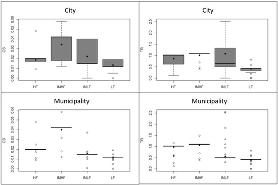
Figure 3.
One-way ANOVA comparing the delivery of carbon sequestration (CS) and temperature regulation (TR) under four types of scenarios. LF: current state of low functioning sites. HF: current state of high-functioning sites. IMLF: improvement/restoration scenario of low-functioning sites. IMHF: improvement/restoration scenario of high functioning sites at city and municipality scale. Hollow dots represent outliers. Black dots represent the mean value.
Table 2.
p-values for ANOVA for different types of scenarios, LF (current situation of sites with low value of functioning), HF (current situation of sites with high value of functioning), IMLF (improvement of sites with low value of functioning), and IMHF (improvement of sites with high value of functioning), for carbon sequestration (CS). CS × Area, temperature regulation (TR), and TR × Area for the city and municipality scale, as well as the p-value for the post hoc tests between different scenarios for the city and municipality scale. Diff stands for the difference between the means (* stands for significant (p-value < 0.05). N/A stands for non-available).
Likewise, a one-way ANOVA for TR revealed that there was a statistically significant difference in mean between the different types of scenarios (p-value < 2 × 10⁻¹⁶). Contrary to CS × Area, the ANOVA for TR × Area exhibited a significant difference (p-value = 0.0149). Tukey’s post hoc test for TR found that the mean value was not significantly different from IMHF–HF (p-value = 0.105) and IMLF–IMHF (p-value= 0.548) but was significantly different for all other scenarios (p < 0.05). Tukey’s post hoc test for TR × Area revealed that there was a statistically significant difference in mean only for LF–IMHF (p-value-0.027) and LF–IMLF (p-value = 0.035). For the rest, there was no significant difference (Table 2) (Figure S3).
At the municipality scale, for CS, a one-way ANOVA revealed that there was a statistically significant difference in mean between the different types of scenarios (p-value < 2 × 10⁻¹⁶) (Figure 3). The same thing happened when multiplying the CS by area, and a significant difference was found (p < 2 × 10⁻¹⁶). Tukey’s post hoc test for CS found that the mean value was significantly different from all different scenarios (p < 0.05). As for CS × Area, the post hoc revealed that there was no significant difference except for the LF–IMLF scenario (p-value = 0.93). For the rest, there were significant differences (Table 2).
The ANOVA for TR revealed that there was a statistically significant difference in mean between the different types of scenarios (p-value < 2 × 10⁻¹⁶). The same thing happened when multiplying the TR by area, and a significant difference was found (p < 2 × 10⁻¹⁶). Tukey’s post hoc test for TR found that the mean value was significantly different between all different scenarios (p < 0.05). Tukey’s post hoc test for TR × Area revealed that there was no significant difference in mean except for HF–IMHF (p-value = 0.152) and LF–IMLF (p-value = 0.298). For the rest, there was a significant difference (Table 2) (Figure S3).
4. Discussion
4.1. Typology of the UGI
The results highlighted the landscape difference between the urban and peri-urban areas. In particular, they show that peri-urban areas are dominated by sites with high ecological functioning, while urban areas are dominated by low-functioning green zones because these urban green areas were constructed mostly as recreational hubs to contribute to the overall well-being of urban residents [39]. Additionally, the presence of natural ecosystems, such as rivers in this city, holds ecological importance. Rivers and their riparian areas, being high-functioning sites, provide a habitat for diverse flora and fauna [40] that can counter-balance the low functioning of more artificial sites, such as urban parks. Hence, there is an important need for the conservation and careful restoration of these rivers and their riparian zones, as well as other natural sites, in order to balance human needs and environmental conservation in the city [41].
4.2. Insights into Carbon Sequestration and Temperature Regulation at City and Municipality Scales
Overall, the restoration scenarios showed positive trends in both carbon sequestration and temperature regulation for various UGI types. At the city scale, a statistically significant difference in carbon sequestration among scenarios was observed. However, when considering carbon sequestration by area, the difference became non-significant. These findings reveal that improving carbon sequestration under improved scenarios is not influenced by the area of the UGI site but by the type of the green infrastructure site. For instance, for climate adaptation, city planners should think cost-effectively. They should focus on restoring and conserving urban green sites with high carbon sequestration potential, such as urban forests, as they act as carbon sinks inside the city [42], instead of wasting resources on restoring lower-performing sites such as roundabouts. Another approach is to imitate the complexity of urban forests by planting different species with different numbers of strata when designing new urban green zones. This sheds light on the importance of our approach and could lead policymakers to decide where to prioritize their efforts for the restoration and conservation of urban green infrastructure.
Regarding temperature regulation at the city scale, there was a statistically significant difference in mean between the different types of scenarios. Contrary to CS × Area, the ANOVA for TR × Area showed significant differences. Tukey’s post hoc test for TR found that the mean value was not significantly different between the scenario of the current state of high-functioning sites and the scenario of improving high-functioning sites. Similarly, there is no significant difference between the scenarios of improving low-functioning sites and improving high-functioning sites. These findings suggest that the impact of urban planning interventions may not be significantly different for high-functioning urban green infrastructure sites if planned only to reach the maximum TR observed currently. However, such was not the case for low-functioning sites because there were statistically significant differences only between the scenario of the current state of low-functioning sites and the scenario of improving high-functioning sites, analogously between the scenario of the current state of low-functioning sites and the scenario of improving low functioning sites. These significant differences suggest that there are meaningful changes in temperature regulation outcomes when transitioning from the current state of low-functioning sites to either improving high-functioning sites or improving low-functioning sites. Hence, decision-makers should propose restoration strategies that involve restoring low-functioning sites or even improving the functioning of low-functioning sites. This is in good agreement with previous studies highlighting the cooling effects of urban parks (low-functioning UGI sites) in assisting urban planning and decision-makers in mitigating the urban heat island effect and improving urban sustainability [43,44]. Other low-functioning UGI sites have the same importance. For instance, street trees, as urban green infrastructure sites with low functioning values, play an important role in temperature regulation in cities, presenting cooling refuges, providing shading for the citizens, and playing a role in the evapotranspiration process, which can help in cooling their surroundings [45].
At the municipality scale, for CS, there was a statistically significant difference in mean between all different types of scenarios. The same thing happened when multiplying the CS value by area, and a significant difference was found. As for CS × Area, there was no significant difference between the scenario of current low-functioning sites and improving low-functioning sites scenario. This suggested that carbon sequestration is not only influenced by the total amount of carbon accumulated but also by the area and distribution of UGI across the municipality. Additionally, the results indicated that when multiplying CS by area, the carbon sequestration of the scenarios of restoring low-functioning sites is statistically similar to the current state of low-functioning sites. Therefore, at a municipality scale, policymakers should focus their efforts on restoring and conserving high-functioning sites, as it has been proven that restoring these green zones is a winning strategy for storing carbon. Moreover, restoring the ecological functioning of those UGI sites, where it is still possible, would increase carbon sequestration. The results are consistent with previous studies, showing the importance of managing and restoring high-functioning sites (such as forests) due to their significant role in absorbing carbon and mitigating climate change [46,47]. As for temperature regulation, at a municipal scale, the results showed that the restoration scenarios were only effective in regulating temperature but inefficient in doing so relative to their area. Hence, policymakers and urban planners are encouraged to explore other factors, such as vegetation density, local climate conditions, the location of green sites, and the role of these green zones (green corridors connecting the peri-urban to the urban) that could influence the regulation of temperature at municipality scale, especially in peri-urban areas where the results of restoration of TR × Area in the city are significant. However, it is important to note that in peri-urban areas, the impact of individual UGI sites on temperature regulation could be localized, providing cooling effects to the immediate surroundings, because there are few people living in these areas. Thus, it has less importance except in the case that these green zones are strategically planned and interconnected (corridors and patches), which can result in landscape connectivity, producing a combined influence contributing to the reduction of urban heat islands [48].
4.3. The Importance of Peri-Urban Areas
Comparing the city scale and municipality scale (city + peri-urban areas) has shown that the green infrastructure in peri-urban zones has an important role in the provision of ecosystem service. Our study has proved that UGIs in peri-urban areas are big areas that tend to show higher capacities for carbon sequestration compared to their city counterparts. These vast lands not only facilitate the growth of more complex vegetation but also enable the development of ecologically diverse landscapes, causing increased carbon absorption and storage [49]. The results are in line with previous studies, highlighting the importance of maintenance and restoration of large functional UGIs dominated by natural processes, dynamics, and structures that display permeable surfaces and undisturbed hydro-morphology that can threaten the livability of urban areas in the short term as a consequence of global warming [9,50]. These peri-urban zones can play a crucial role in mitigating climate change by acting as valuable carbon sinks [51]. Additionally, they offer a diversity of urban green infrastructure elements that are not present in the city, such as pastures [52], where soils under a range of pasture types have considerable potential for sequestration of atmospheric CO2. Furthermore, the magnitude of this potential can be greatly modified by pasture management practices [53].
Forests were another type of green infrastructure dominant in the peri-urban area of Zaragoza. They can play a large role in climate change through the sequestration of carbon through biological growth, which can increase carbon fixation. Carbon is captured not only in tree biomass but mostly in forest soils [54]. Management practices for enhancing soil C stock in forests consist of careful site preparation, adequate soil drainage, growing species with a high net primary production, applying N and micronutrients (Fe) as fertilizers or biosolids, and conserving soil and water resources [55]. However, forest restoration should not be performed in other types of habitats, such as steppe zones, because the latter have intrinsic features and provide specific ecosystem services (e.g., they harbor a highly valued specific biodiversity, both plant and animal communities, based on gypsum soils).
In addition, the steppe (herbaceous vegetation associations) zones of Zaragoza, occupying large areas in the north and south peri-urban zones, are highly covered by herbaceous vegetation associations. Despite their seemingly harsh conditions, they possess extensive root systems that play a crucial role in storing carbon below the ground, thus having high sequestration potential [56,57,58]. However, herbaceous vegetation cannot provide TR, like forests do, because of its low height and density compared to tree associations.
Thus, the peri-urban areas of Zaragoza consist of a great variety of UGI types, which, if adequately restored and connected, have the potential to contribute high CS net values that could help to address the challenges of climate change. Such is not the case for the highly urbanized zones of Zaragoza.
4.4. Priority Analysis
Providing temperature regulation by urban green infrastructure sites had a direct impact on the city scale due to the need for cool and shade refuges for citizens in the face of heat [59]. However, on the municipality scale, carbon sequestration is most significant due to the importance of peri-urban areas contributing as carbon sinks to reduce the effect of climate change [51]. In terms of temperature regulation, urban parks and rivers have the highest priority for restoration, so urban planners and decision-makers should focus on restoring the riparian areas of the rivers and restoring parks through revegetation and providing comfortable shelters. These areas have a high potential to be climate refuges, especially in the hot summer weather of Zaragoza [60], due to their dominant presence in the city (Figure S4). This is followed by urban forests, canals, and cemeteries. It is important to restore and preserve these areas as they come in second place in priority (Figure S4). The other 13 types are of less importance in terms of carbon storage.
We recommend decision-makers follow the Pareto principle that states that roughly 80% of outcomes (temperature regulation) come from 20% of causes (urban green infrastructure sites) [61] when allocating resources for restoring urban green infrastructure to fight climate change in the city. In our case, restoring the elements of the urban green infrastructure of first and second priority, which represents 27.7% of the total area of UGI, could be enough to produce an 80% outcome of temperature regulation. However, decision-makers do not have to restore all elements of urban green infrastructure, i.e., all types (Figure 4 and Figure S4).
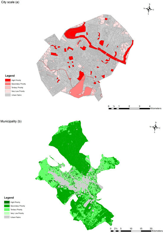
Figure 4.
(a) Priority map of restoration for temperature regulation (TR) in the city. (b) Priority map of restoration for carbon sequestration (CS) in the municipality.
Priority analysis also showed that the highest restoration priority goes to pastures due to their large area and their capacity for carbon intake. Forests and steppes (herbaceous vegetation associations) come second in priority. All are high-functioning green infrastructure sites. Hence, the importance of these sites cannot be neglected. We recommend decision makers focus their efforts on restoring and conserving these areas as they present high potential in storing carbon in the soil and thus maintain a balance with the potential pollution that comes from the city (Figure 4 and Figure S4).
4.5. Contribution to a Climate Neutral Municipality
According to the European Union (https://research-and-innovation.ec.europa.eu accessed on 18 November 2023), cities play a pivotal role in achieving climate neutrality by 2050, the goal of the European Green Deal. They take up only 4% of the EU’s land area, but they are home to 75% of EU citizens. Furthermore, cities consume over 65% of the world’s energy and account for more than 70% of global CO2 emissions. In this study, the results showed that there is no significant difference when we multiply the value of carbon sequestration by area in the improved scenario on a city scale. So, new UGI areas could be required to achieve a significant impact and contribute to the climate neutrality of a European city like Zaragoza, Spain. We raised two questions: supposing that the restoration scenarios are already in place in the city, how much area is required to improve carbon sequestration delivered by UGI in cities by 50%? Additionally, can policymakers find space to build these areas? To answer the first question, we calculated the area needed for the different percentages of CS increase.
The LU/LC map showed that there is land without current use with a total area of 2,591,334.30 m2 (Figure S5), if we suppose that the municipality can interfere and build new UGI elements on these sites. If so, it will achieve a 28.14% (not 50%) increase in the carbon sequestration provided by the UGI elements in the city, helping Zaragoza city to reach their objective to be a neutral city by 2030 (Figure S6). We also recommend that city planners design UGI elements with high functioning in these lands according to the biogeographic location of the site. In any case, it was demonstrated that high-functioning sites are efficient in storing carbon in the soil.
4.6. Value and Limitations of the Approach
In this paper, we aimed to contribute to filling the gap in research on the subject of ecosystem services and climate adaptation strategies in medium-sized cities [62]. Many investigations studied the potential of greeneries to mitigate urban heat islands and greenhouse gas emissions through carbon storage [63,64,65]. However, to the best of our knowledge, a comparative study assessing carbon sequestration and temperature regulation separately in relation to climate adaptation of urban zones is lacking. To make informed decisions about the restoration strategies for the improvement of UGI, it is important to know which types of sites can provide better carbon accumulation and regulate air temperature, the two most relevant ESs to buffer climate change impacts.
The presented approach allows us to prioritize restoration at a municipality and city scale, selecting areas according to their CS and TR capacities in the face of climate change. The majority of restoration research was planned at the ecosystem scale, with reference ecosystems being used to define restoration operations and success [66]. Restoration plans based on the provision of multiple ES at the territory scale are an innovative approach [67]. In order to determine the zones where high values of services are present, which increases the significance of the selected zones, the evaluation of various ESs is based on the location of the UGI sites that provide these two ESs.
Focusing restoration efforts not only at the city scale but also at a larger scale is important for addressing the intricate challenges of environmental conservation and climate resilience [68]. While working on a city scale provides an easy and direct perspective on urban health [69], working on a larger scale allows for a more global approach. Hence, broadening the perspective could be cost-effective in the long term and reveal hidden information and mechanisms that urban planners might have neglected [70]. For instance, they might design restoration strategies for urban parks only dominant on the city scale (not present in peri-urban areas). If decision-makers provide targeted restoration measurements for urban parks that have specific characteristics and neglect the other types of urban green infrastructure dominantly present in peri-urban areas, such as pastures that play an important part in carbon sequestration, they could be wasting resources. Thus, our approach ensures a comprehensive and informed restoration strategy for policymakers, decision-makers, and urban planners, optimizing environmental benefits and resource utilization in the context of climate adaptation.
Although our approach to scenario analysis of green infrastructure delivery of ecosystem services to reduce the impact of climate change is robust and strategic, it is important to recognize that it has certain limitations. One important factor is that the spatial data used may become outdated with time, and the effectiveness of interventions can be influenced by future urban developments. For instance, in our approach, we used an LU/LC map from Copernicus dated 2018. Changes in land use and land cover may have occurred, though not drastically. Additionally, the LU/LC map does not differentiate between the different types of UGI in the city. Therefore, we had to use the data of UGI sites that were studied by Hanna et al. (2023) [33], which evaluated UGIs in Zaragoza. Furthermore, our approach focused primarily on the ESs of TR and CS. Other ecosystem services, such as water regulation [71] and habitat biodiversity [72], could also contribute to climate adaptation. Further investigation is required to study the scenario analysis of other ecosystem services provided by urban green infrastructure and their relation to climate change adaptation and urban planning. This approach could also be combined with other UGI characteristics of interest, such as connectivity between sites, which can be relevant for the contribution of UGI to buffer climate change.
5. Conclusions
The UGI of Zaragoza was mostly characterized by low functioning sites located in the densely urbanized area of the city. High-functioning UGI sites were located in the peri-urban area of the city. A similar pattern was found in other European cities [73]. Therefore, the methodology proposed here for the restoration of UGIs could be applicable in other medium-sized cities.
Scenario analysis based on ecosystem services is a useful tool for predicting the impact of restoration measurements to fight against climate change in urban zones. Restoring high ecological functioning green infrastructure sites (forests, steppes, and riparian areas) in peri-urban zones is of high importance. This will improve the provision of carbon sequestration due to the increase of both the carbon sequestration rate and the area of available sites. However, in densely built zones, the provision of carbon sequestration will not improve because of the generalized lack of large areas of sites with good ecological functioning. Temperature regulation will increase in both city and peri-urban zones after restoration. However, it is recommended to restore green infrastructure sites for temperature regulation in densely populated zones because of their direct benefit to more inhabitants. This presented research makes a significant contribution to the growing body of literature in the field of adapting to climate change. It maximizes environmental benefits and resources, helping urban planners and policymakers prioritize UGI sites to address carbon accumulation and temperature regulation within the context of climate adaptation.
Supplementary Materials
The following supporting information can be downloaded at https://www.mdpi.com/article/10.3390/land13030280/s1, Figure S1: (a) Percentage of the sum of the area of each UGI element at the municipality scale. (b) Percentage of the sum of the area of each UGI element at the city scale. Figure S2: (a) Carbon sequestration (CS) of each UGI element. (b) Temperature (TR) of each type of UGI site. Figure S3: Post hoc test showing the means and the difference in means levels of different types of scenarios for carbon sequestration (CS), CS × Area, temperature regulation (TR), and TR × Area for the municipality scale and city scale. LF (current situation of sites with low value of functioning), HF (current situation of sites with high value of functioning), IMLF (improvement of sites with low value of functioning), and IMHF (improvement of sites with high value of functioning). Figure S4: (a) Priority analysis of restoration for temperature regulation (TR) by area in the city and sum of TR × Area (°C). (b) Priority analysis of restoration for carbon sequestration (CS) by area in the municipality. Sum of CS × Area (g). Figure S5: Map of land without current use in the city, where new urban green infrastructure sites could be designed by the municipality of Zaragoza to increase carbon storage in the city. Figure S6: Graph showing the area needed to improve carbon sequestration delivered by UGIs in cities by 1%, 5%, 10%, 20%, 30%, 40%, and 50%.
Author Contributions
Conceptualization, E.H., M.R.F.-L. and F.A.C.; methodology, E.H., M.R.F.-L. and F.A.C.; software, E.H.; validation, E.H. and F.A.C.; formal analysis, E.H. and F.A.C.; investigation, E.H. and F.A.C.; resources, E.H. and F.A.C.; data curation, E.H.; writing—original draft preparation, E.H.; writing—review and editing, E.H., M.R.F.-L. and F.A.C.; visualization, E.H.; supervision, F.A.C.; project administration, F.A.C. All authors have read and agreed to the published version of the manuscript.
Funding
This research received no external funding.
Data Availability Statement
Data are contained within the article.
Acknowledgments
The authors wish to acknowledge Elizabeth Mickaily-Huber of Liberty University (USA) for her English language review and corrections.
Conflicts of Interest
The authors declare no conflicts of interest.
Appendix A

- Questionnaire on criteria for improving and creating green infrastructure in the city of Zaragoza to adapt to climate change (Translated from Spanish).
Green infrastructure refers to all types of spaces with natural components (soil, vegetation, and water) and artificial components (spaces for recreation, shows, and rest), including aquatic spaces, which provide environmental services for the human population (e.g., carbon accumulation, wind or flood buffering, and recreation) and are subject to natural processes (water flows, connection with water channels, wind erosion, etc.) or artificial processes (garbage and leaf litter cleaning, irrigation, planting, etc.).
The objective of this survey was to obtain the opinion of experts and stakeholders on the characteristics and spatial distribution that the green spaces of Zaragoza should have to mitigate the effects of climate change.
The study focuses on green spaces larger than 1 ha, excluding those with highly artificial morphology, such as streets with tree alignments. The following table includes various criteria for planning and building spaces that form Zaragoza’s green infrastructure with the aim of mitigating the impacts of climate change and adapting the city to these changes.
| Criteria | Definition | Ranking (0–10) | Rating (0–100%) |
| Naturalness and functioning | Naturalness: percentage of surface covered with natural components (soil, vegetation, water). Functioning: percentage of surface subject to natural processes (water flows, accumulation and decomposition of leaf litter contributing to soil formation). | ||
| Cultural use | Contribution of the site to recreational functions (games, concerts, shows, entertainment) enjoyed by the population. | ||
| Economic cost | Expenses associated with maintaining or building a green space | ||
| Biodiversity | Capacity to harbor biodiversity | ||
| Potential users | Population density around the green space | ||
| Connectivity | Degree of connectivity between the different green spaces | ||
| Size | Surface area occupied by the green space |
- Question 1: Review the list of criteria from the previous table and add or remove criteria as you consider them interesting or important for planning and building green spaces that form the green infrastructure network of the city of Zaragoza.
Please write them in the first column of the table and define them in the second column.
- Question 2: Rate from 0 to 10 the importance of each green infrastructure criterion for mitigating the effects of climate change or adapting to them in the city of Zaragoza, with 10 being the highest value and 0 being the lowest.
Write your evaluation (including decimals if you consider it appropriate) in the third column of the table (Ranking).
- Question 3: In the fourth column (Rating), distribute 100 points among the criteria in the table so that the total adds up to 100%. That is, if one criterion is assigned 100%, the other criteria should be assigned 0%; or if one criterion is assigned 50%, then the remaining 50% will be distributed among the other criteria.
- Question 4: Which option from the following list do you consider most suitable for mitigating the effects of climate change in Zaragoza? Mark with a cross your preferred option (only one response)
- ○
- Leave the green spaces as they are because they are already sufficient in number and extent;
- ○
- Improve existing green spaces;
- ○
- Create new green areas;
- ○
- Both improve existing ones and create new ones;
- ○
- Other:
- Question 5: In your opinion, how can existing green spaces be improved? Assign an order of importance to each of the following options, with 1st being the most important. If you consider it appropriate, you can assign the same order of importance to more than one option, as well as add new options.
| Expanding their size | |
| Improving their naturalness and functioning | |
| Increasing connectivity with other green spaces | |
| Adding recreational and entertainment elements | |
| Facilitating access to green spaces | |
| Increasing investment in maintenance | |
| Other: | |
| Other: |
- Question 6: Where would you establish new green spaces in different areas of Zaragoza? Assign a preference order to each of the following options, with number 1 being the most important. If you consider it appropriate, you can assign the same preference order to more than one option, as well as add other options.
| In the consolidated urban area: from the old town to the third belt (Z-30) | |
| In the non-consolidated urban area: areas between the third (Z-30) and fourth (Z-40) belt, where buildings are being constructed or planned | |
| In the peri-urban area: areas beyond the fourth belt (Z-40) and also some non-built areas or orchards between Z-30 and Z-40. | |
| In the consolidated urban area: from the old town to the third belt (Z-30) | |
| Other: | |
| Other: |
- Question 7: Mark on these maps some locations where you suggest new green areas could be created to improve Zaragoza’s green infrastructure and adapt to climate change. (You can move the star with the cursor to the right of each map to the suggested position and copy it to as many locations as you believe are appropriate to establish new green areas)


Thank you very much for your participation! Please send this completed document to co-min@ipe.csic.es.
If you have any comments or suggestions about the survey or about Zaragoza’s green infrastructure, feel free to write them here or contact us directly via email.
References
- United Nations, Department of Economic and Social Affairs, Population Division. World Urbanization Prospects: The 2014 Revision; (ST/ESA/SER.A/366); United Nations: New York, NY, USA, 2015.
- Chai, K.-C.; Ma, X.-R.; Yang, Y.; Lu, Y.-J.; Chang, K.-C. The impact of climate change on population urbanization: Evidence from China. Front. Environ. Sci. 2022, 10, 945968. [Google Scholar] [CrossRef]
- Ren, Z.; Fu, Y.; Dong, Y.; Zhang, P.; He, X. Rapid urbanization and climate change significantly contribute to worsening urban human thermal comfort: A national 183-city, 26-year study in China. Urban Clim. 2022, 43, 101154. [Google Scholar] [CrossRef]
- Church, J.A.; White, N.J.; Aarup, T.; Wilson, W.S.; Woodworth, P.L.; Domingues, C.M.; Hunter, J.R.; Lambeck, K. Understanding global sea levels: Past, present and future. Sustain. Sci. 2008, 3, 9–22. [Google Scholar] [CrossRef]
- Zell, R. Global climate change and the emergence/re-emergence of infectious diseases. Int. J. Med. Microbiol. Suppl. 2004, 293, 16–26. [Google Scholar] [CrossRef]
- Hobbie, S.E.; Grimm, N.B. Nature-based approaches to managing climate change impacts in cities. Philos. Trans. R. Soc. B Biol. Sci. 2020, 375, 20190124. [Google Scholar] [CrossRef]
- Bolund, P.; Hunhammar, S. Ecosystem services in urban areas. Ecol. Econ. 1999, 29, 293–301. [Google Scholar] [CrossRef]
- Mell, I. Green Infrastructure: Reflections on Past, Present and Future Praxis; Routledge: London, UK, 2018; pp. 1–11. [Google Scholar] [CrossRef]
- Hanna, E.; Bruno, D.; Comín, F.A. The ecosystem services supplied by urban green infrastructure depend on their naturalness, functionality and imperviousness. Urban Ecosyst. 2023, 27, 187–202. [Google Scholar] [CrossRef]
- Hanna, E.; Comín, F.A. Urban Green Infrastructure and Sustainable Development: A Review. Sustainability 2021, 13, 11498. [Google Scholar] [CrossRef]
- Pauleit, S.; Zölch, T.; Hansen, R.; Randrup, T.B.; Konijnendijk van den Bosch, C. Nature-based solutions and climate change—Four shades of green. In Nature-Based Solutions to Climate Change Adaptation in Urban Areas: Linkages between Science, Policy and Practice; Springer: Cham, Switzerland, 2017; pp. 29–49. [Google Scholar]
- EEA. The European Environment. State and Outlook; European Environment Agency: Copenhagen, Denmark, 2010. [Google Scholar]
- Lafortezza, R.; Davies, C.; Sanesi, G.; Konijnendijk, C. Green Infrastructure as a tool to support spatial planning in European urban regions. iForest-Biogeosci. For. 2013, 6, 102–108. [Google Scholar] [CrossRef]
- De Zeeuw, H.; Drechsel, P. Cities and agriculture. In Developing Resilient Urban Food Systems; RUAF Foundation: The Hague, The Netherlands, 2015. [Google Scholar]
- Salata, K.D.; Yiannakou, A. Green Infrastructure and climate change adaptation. TeMA J. Land Use Mobil. Environ. 2016, 9, 7–24. [Google Scholar] [CrossRef]
- Reid, W.; Mooney, H.; Cropper, A.; Capistrano, D.; Carpenter, S.; Chopra, K.; Dasgupta, P.; Dietz, T.; Duraiappah, A.; Hassan, R.; et al. Millenium Ecosystem Assessment Synthesis Report; Island Press: Washington, DC, USA, 2005. [Google Scholar]
- Dominati, E.; Patterson, M.; Mackay, A. A framework for classifying and quantifying the natural capital and ecosystem services of soils. Ecol. Econ. 2010, 69, 1858–1868. [Google Scholar] [CrossRef]
- Holt, A.R.; Alix, A.; Thompson, A.; Maltby, L. Food production, ecosystem services and biodiversity: We can’t have it all everywhere. Sci. Total. Environ. 2016, 573, 1422–1429. [Google Scholar] [CrossRef]
- Milcu, A.I.; Hanspach, J.; Abson, D.; Fischer, J. Cultural Ecosystem Services. Ecol. Soc. 2013, 18, 44. Available online: http://www.jstor.org/stable/26269377 (accessed on 1 November 2023). [CrossRef]
- Nair, R.; Mehta, C.R.; Sharma, S. Carbon sequestration in soils—A Review. Agric. Rev. 2015, 36, 81–99. [Google Scholar] [CrossRef]
- Townsend-Small, A.; Czimczik, C.I. Carbon sequestration and greenhouse gas emissions in urban turf. Geophys. Res. Lett. 2010, 37, L02707. [Google Scholar] [CrossRef]
- Bellet, C.; Llop, J. Ciudades Intermedias, Perfiles y Pautas. In Segunda Fase del Programa CIMES: Ciudades Intermedias y Urbanización Mundial; Municipality of Lleida: Lleida, Spain, 2003. [Google Scholar]
- Amorim-Maia, A.T.; Anguelovski, I.; Connolly, J.; Chu, E. Seeking refuge? The potential of urban climate shelters to address intersecting vulnerabilities. Landsc. Urban Plan. 2023, 238, 104836. [Google Scholar] [CrossRef]
- Lumeng, L.; Jianguo, W. Scenario analysis in urban ecosystem services research: Progress, prospects, and implications for urban planning and management. Landsc. Urban Plan. 2022, 224, 104433. [Google Scholar]
- Millenium Ecosystem Assessment, Living Beyond our Means: Natural Assets and Human Well-Being. Statement from the Board. 2008. Available online: https://www.sysecol2.ethz.ch/AR4_Ch04/Ch4-GreyLit/Mi112.pdf (accessed on 17 November 2023).
- Felipe-Lucia, M.R.; de Frutos, A.; Comín, F.A. Modelling landscape management scenarios for equitable and sustainable futures in rural areas based on ecosystem services. Ecosyst. People 2022, 18, 76–94. [Google Scholar] [CrossRef]
- Alcamo, J.; van Vuuren, D.; Ringler, C. Methodology for developing the MA scenarios. In Ecosystems and Human Well-Being: Scenarios; Island Press: Washington, DC, USA, 2005; Volume 2, pp. 145–172. [Google Scholar]
- Peterson, G.D.; Cumming, G.S.; Carpenter, S.R. Scenario planning: A tool for conservation in an uncertain world. Conserv. Biol. 2003, 17, 358–366. [Google Scholar] [CrossRef]
- Van Oijstaeijen, W.; Van Passel, S.; Cools, J. Urban green infrastructure: A review on valuation toolkits from an urban planning perspective. J. Environ. Manag. 2020, 267, 110603. [Google Scholar] [CrossRef] [PubMed]
- Berg, C.; Rogers, S.; Mineau, M. Building scenarios for ecosystem services tools: Developing a methodology for efficient engagement with expert stakeholders. Futures 2016, 81, 68–80. [Google Scholar] [CrossRef]
- Tejedor, E.; Cuadrat, J.; Saz, M.; Serrano-Notivoli, R.; López, N.; Aladrén, M. Islas de Calor y Confort Térmico en Zaragoza Durante la ola de Calor de Julio de 2015; Universidad de Alicante: San Vicente del Raspeig, Spain, 2016; pp. 141–151. [Google Scholar] [CrossRef]
- Berg, L.V.D.; Pol, P.M.; Van Winden, W.; Woets, P. European Cities in the Knowledge Economy: The Cases of Amsterdam, Dortmund, Eindhoven, Helsinki, Manchester, Munich, Münster, Rotterdam and Zaragoza; Routledge: London, UK, 2017. [Google Scholar] [CrossRef]
- Hanna, E.; Bruno, D.; Comín, F.A. Evaluating naturalness and functioning of urban green infrastructure. Urban For. Urban Green. 2023, 80, 127825. [Google Scholar] [CrossRef]
- Daba, M.H.; Dejene, S.W. The role of biodiversity and ecosystem services in carbon sequestration and its implication for climate change mitigation. Environ. Sci. Nat. Resour. 2018, 11, 1–10. [Google Scholar]
- Smith, P. Soils as carbon sinks: The global context. Soil Use Manag. 2004, 20, 212–218. [Google Scholar] [CrossRef]
- Stoycheva, V.; Geneletti, D. A review of regulating ecosystem services in the context of urban planning. J. Bulg. Geogr. Soc. 2023, 48, 27–42. [Google Scholar] [CrossRef]
- Kraemer, R.; Kabisch, N. Parks under stress: Air temperature regulation of urban green spaces under conditions of drought and summer heat. Front. Environ. Sci. 2022, 10, 318. [Google Scholar] [CrossRef]
- Trabucchi, M.; O’Farrell, P.J.; Notivol, E.; Comín, F.A. Mapping ecological processes and ecosystem services for prioritizing restoration efforts in a semi-arid Mediterranean river basin. Environ. Manag. 2014, 53, 1132–1145. [Google Scholar] [CrossRef] [PubMed]
- Kothencz, G.; Kolcsár, R.; Cabrera-Barona, P.; Szilassi, P. Urban green space perception and its contribution to well-being. Int. J. Environ. Res. Public Health 2017, 14, 766. [Google Scholar] [CrossRef] [PubMed]
- Francis, R.A.; Hoggart, S.P. Urban river wall habitat and vegetation: Observations from the River Thames through central London. Urban Ecosyst. 2009, 12, 465–485. [Google Scholar] [CrossRef]
- National Research Council. Riparian Areas: Functions and Strategies for Management; National Academies Press: Washington, DC, USA, 2002. [Google Scholar]
- Muslih, A.M.; Nisa, A.; Sugianto; Arlita, T. The Role of Urban Forests as Carbon Sink: A Case Study in the Urban Forest of Banda Aceh, Indonesia. J. Sylva Lestari 2022, 10, 417–425. [Google Scholar] [CrossRef]
- Yao, X.; Yu, K.; Zeng, X.; Lin, Y.; Ye, B.; Shen, X.; Liu, J. How can urban parks be planned to mitigate urban heat island effect in ‘Furnace cities’? An accumulation perspective. J. Clean. Prod. 2021, 330, 129852. [Google Scholar] [CrossRef]
- Yang, P.; Xiao, Z.-N.; Ye, M.-S. Cooling effect of urban parks and their relationship with urban heat islands. Atmospheric Ocean. Sci. Lett. 2016, 9, 298–305. [Google Scholar] [CrossRef]
- Armson, D.; Rahman, M.A.; Ennos, A.R. A comparison of the shading effectiveness of five different street tree species in Manchester, UK. Arboric. Urban For. 2013, 39, 157–164. [Google Scholar] [CrossRef]
- Bellassen, V.; Luyssaert, S. Carbon sequestration: Managing forests in uncertain times. Nature 2014, 506, 153–155. [Google Scholar] [CrossRef] [PubMed]
- Jindal, R.; Swallow, B.; Kerr, J. Forestry-based carbon sequestration projects in Africa: Potential benefits and challenges. Nat. Resour. Forum 2008, 32, 116–130. [Google Scholar] [CrossRef]
- Peng, J.; Cheng, X.; Hu, Y.; Corcoran, J. A landscape connectivity approach to mitigating the urban heat island effect. Landsc. Ecol. 2022, 37, 1707–1719. [Google Scholar] [CrossRef]
- White, W.A. Biosequestration and Ecological Diversity: Mitigating and Adapting to Climate Change and Environmental Degradation; CRC Press: Boca Raton, FL, USA, 2012. [Google Scholar]
- Ramyar, R.; Zarghami, E. Green infrastructure contribution for climate change adaptation in urban landscape context. Appl. Ecol. Environ. Res. 2017, 15, 1193–1209. [Google Scholar] [CrossRef]
- Mngumi, L.E. Ecosystem services potential for climate change resilience in peri-urban areas in Sub-Saharan Africa. Landsc. Ecol. Eng. 2020, 16, 187–198. [Google Scholar] [CrossRef]
- Davidson, E.A.; Nepstad, D.C.; Klink, C.; Trumbore, S.E. Pasture soils as carbon sink. Nature 1995, 376, 472–473. [Google Scholar] [CrossRef]
- Eyles, A.; Coghlan, G.; Hardie, M.; Hovenden, M.; Bridle, K. Soil carbon sequestration in cool-temperate dryland pastures: Mechanisms and management options. Soil Res. 2015, 53, 349–365. [Google Scholar] [CrossRef]
- Sedjo, R.; Sohngen, B. Carbon sequestration in forests and soils. Annu. Rev. Resour. Econ. 2012, 4, 127–144. [Google Scholar] [CrossRef]
- Lal, R. Forest soils and carbon sequestration. For. Ecol. Manag. 2005, 220, 242–258. [Google Scholar] [CrossRef]
- Wiesmeier, M.; Munro, S.; Barthold, F.; Steffens, M.; Schad, P.; Kögel-Knabner, I. Carbon storage capacity of semi-arid grassland soils and sequestration potentials in northern China. Glob. Chang. Biol. 2015, 21, 3836–3845. [Google Scholar] [CrossRef]
- Araújo, L.G.; de Sousa, D.M.G.; de Figueiredo, C.C.; Rein, T.A.; de Souza Nunes, R.; dos Santos, J.D.D.G.; Malaquias, J.V. How does gypsum increase the organic carbon stock of an Oxisol profile under sugarcane? Geoderma 2019, 343, 196–204. [Google Scholar] [CrossRef]
- Walia, M.K.; Dick, W.A. Gypsum and carbon amendments influence carbon fractions in two soils in Ohio, USA. PLoS ONE 2023, 18, e0283722. [Google Scholar] [CrossRef] [PubMed]
- Pitman, S.D.; Daniels, C.B.; Ely, M.E. Green infrastructure as life support: Urban nature and climate change. Trans. R. Soc. South Aust. 2015, 139, 97–112. [Google Scholar] [CrossRef]
- Cuadrat, J.M.; Vicente-Serrano, S.; Saz, M.A. Influence of different factors on relative air humidity in Zaragoza, Spain. Front. Earth Sci. 2015, 3, 10. [Google Scholar] [CrossRef]
- Dunford, R.; Su, Q.; Tamang, E. The Pareto Principle. Plymouth Stud. Sci. 2014, 7, 140–148. [Google Scholar]
- Biesbroek, G.R.; Swart, R.J.; Carter, T.R.; Cowan, C.; Henrichs, T.; Mela, H.; Morecroft, M.D.; Rey, D. Europe adapts to climate change: Comparing national adaptation strategies. Glob. Environ. Chang. 2010, 20, 440–450. [Google Scholar] [CrossRef]
- Xi, C.; Han, L.; Wang, J.; Feng, Z.; Kumar, P.; Cao, S.-J. How can greenery space mitigate urban heat island? An analysis of cooling effect, carbon sequestration, and nurturing cost at the street scale. J. Clean. Prod. 2023, 419, 138230. [Google Scholar] [CrossRef]
- Chen, R.; You, X.-Y. Reduction of urban heat island and associated greenhouse gas emissions. Mitig. Adapt. Strat. Glob. Chang. 2019, 25, 689–711. [Google Scholar] [CrossRef]
- Rahaman, Z.A.; Al Kafy, A.; Saha, M.; Rahim, A.A.; Almulhim, A.I.; Rahaman, S.N.; Fattah, A.; Rahman, M.T.; Kalaivani, S.; Faisal, A.-A.; et al. Assessing the impacts of vegetation cover loss on surface temperature, urban heat island and carbon emission in Penang city, Malaysia. Build. Environ. 2022, 222, 109335. [Google Scholar] [CrossRef]
- Gann, G.D.; McDonald, T.; Walder, B.; Aronson, J.; Nelson, C.R.; Jonson, J.; Hallett, J.G.; Eisenberg, C.; Guariguata, M.R.; Liu, J.; et al. Principios y estándares internacionales para la práctica de la restauración ecológica. Restor. Ecol. 2019, 27, S1. [Google Scholar]
- Ronchi, S. Ecosystem Services for Spatial Planning: Innovative Approaches and Challenges for Practical Applications; Springer: Cham, Switzerland, 2018. [Google Scholar]
- Demuzere, M.; Orru, K.; Heidrich, O.; Olazabal, E.; Geneletti, D.; Orru, H.; Bhave, A.G.; Mittal, N.; Feliu, E.; Faehnle, M. Mitigating and adapting to climate change: Multi-functional and multi-scale assessment of green urban infrastructure. J. Environ. Manag. 2014, 146, 107–115. [Google Scholar] [CrossRef] [PubMed]
- de Leeuw, E. Do healthy cities work? A logic of method for assessing impact and outcome of healthy cities. J. Urban Health 2011, 89, 217–231. [Google Scholar] [CrossRef] [PubMed]
- von Holle, B.; Yelenik, S.; Gornish, E.S. Restoration at the landscape scale as a means of mitigation and adaptation to climate change. Curr. Landsc. Ecol. Rep. 2020, 5, 85–97. [Google Scholar] [CrossRef]
- Ricart, S.; Villar-Navascués, R.A.; Hernández-Hernández, M.; Rico-Amorós, A.M.; Olcina-Cantos, J.; Moltó-Mantero, E. Extending Natural Limits to Address Water Scarcity? The Role of Non-Conventional Water Fluxes in Climate Change Adaptation Capacity: A Review. Sustainability 2021, 13, 2473. [Google Scholar] [CrossRef]
- Mooney, H.; Larigauderie, A.; Cesario, M.; Elmquist, T.; Hoegh-Guldberg, O.; Lavorel, S.; Mace, G.M.; Palmer, M.; Scholes, R.; Yahara, T. Biodiversity, climate change, and ecosystem services. Curr. Opin. Environ. Sustain. 2009, 1, 46–54. [Google Scholar] [CrossRef]
- Capotorti, G.; Del Vico, E.; Anzellotti, I.; Celesti-Grapow, L. Combining the Conservation of Biodiversity with the Provision of Ecosystem Services in Urban Green Infrastructure Planning: Critical Features Arising from a Case Study in the Metropolitan Area of Rome. Sustainability 2016, 9, 10. [Google Scholar] [CrossRef]


Disclaimer/Publisher’s Note: The statements, opinions and data contained in all publications are solely those of the individual author(s) and contributor(s) and not of MDPI and/or the editor(s). MDPI and/or the editor(s) disclaim responsibility for any injury to people or property resulting from any ideas, methods, instructions or products referred to in the content. |
© 2024 by the authors. Licensee MDPI, Basel, Switzerland. This article is an open access article distributed under the terms and conditions of the Creative Commons Attribution (CC BY) license (https://creativecommons.org/licenses/by/4.0/).