
The Strategic Development of Quality Improvement Land Data Incrementally Using Integrated PESTEL and SWOT Analysis in Indonesia


Abstract
1. Introduction
2. Methods
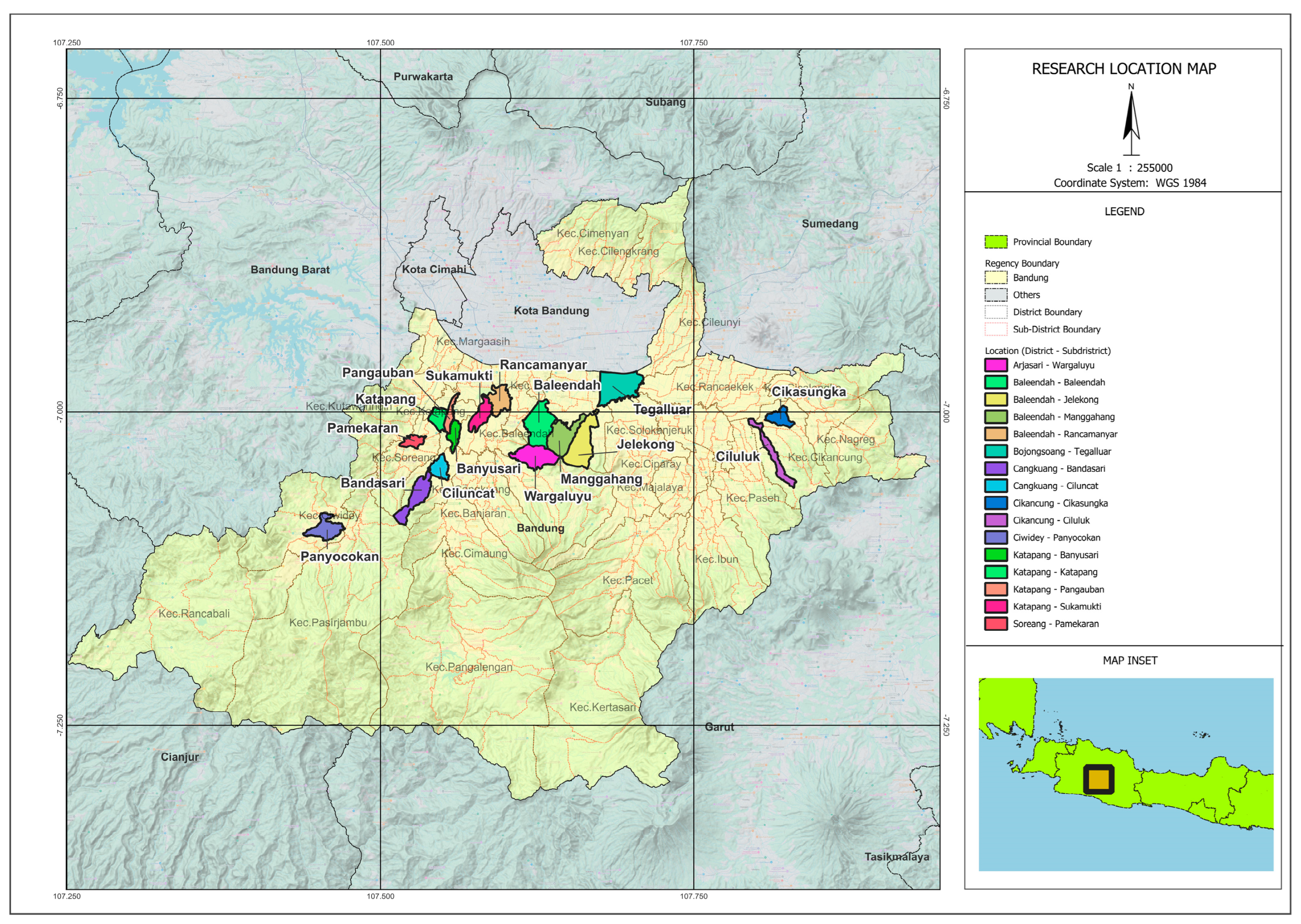
2.1. Study Area
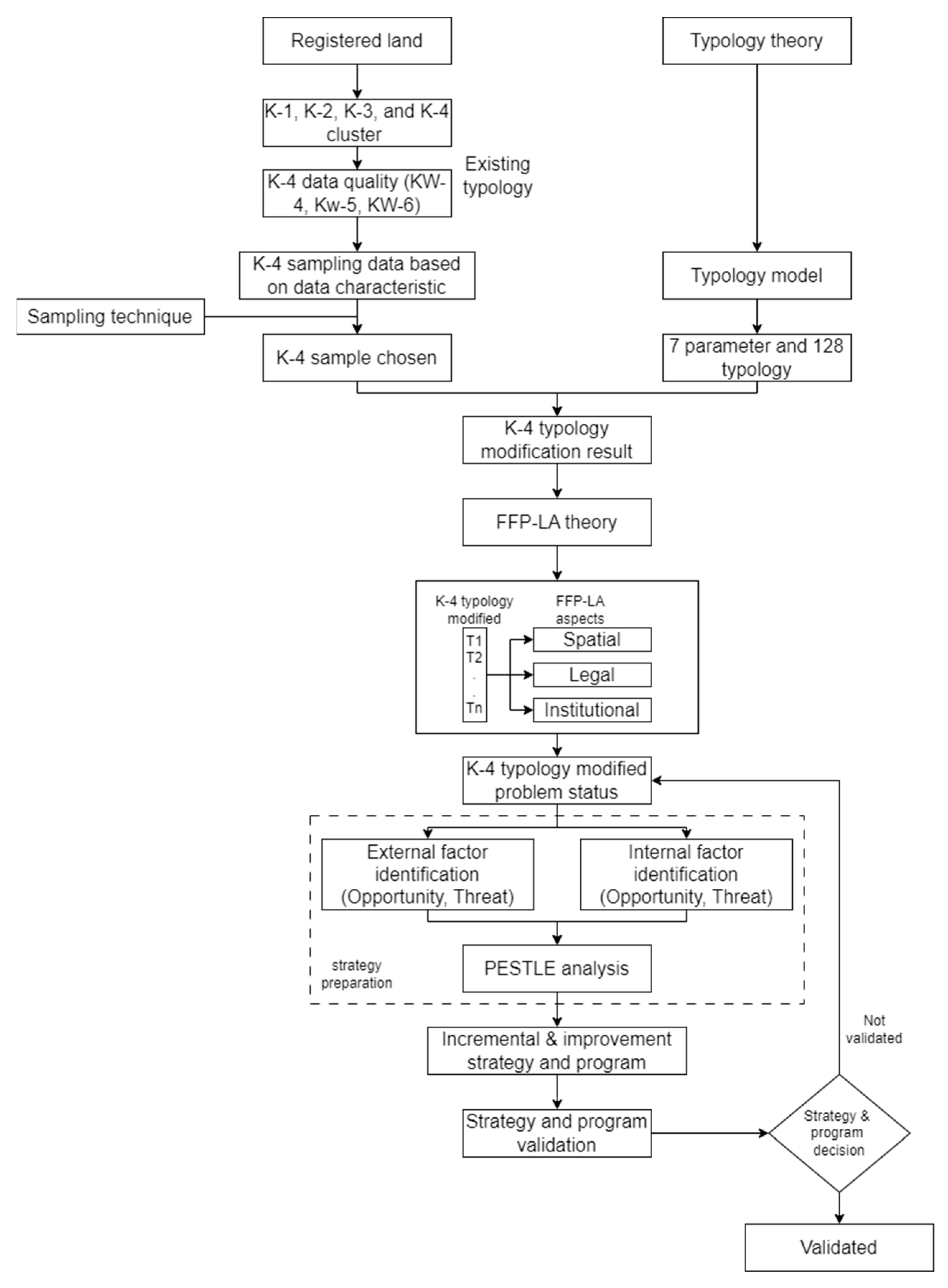
2.2. Research Method
2.3. PTSL Clustering and Land Data Quality
2.4. K-4 Typology
2.5. Sampling Technique
2.6. FFP-LA Concept
2.7. PESTLE Framework
3. Results
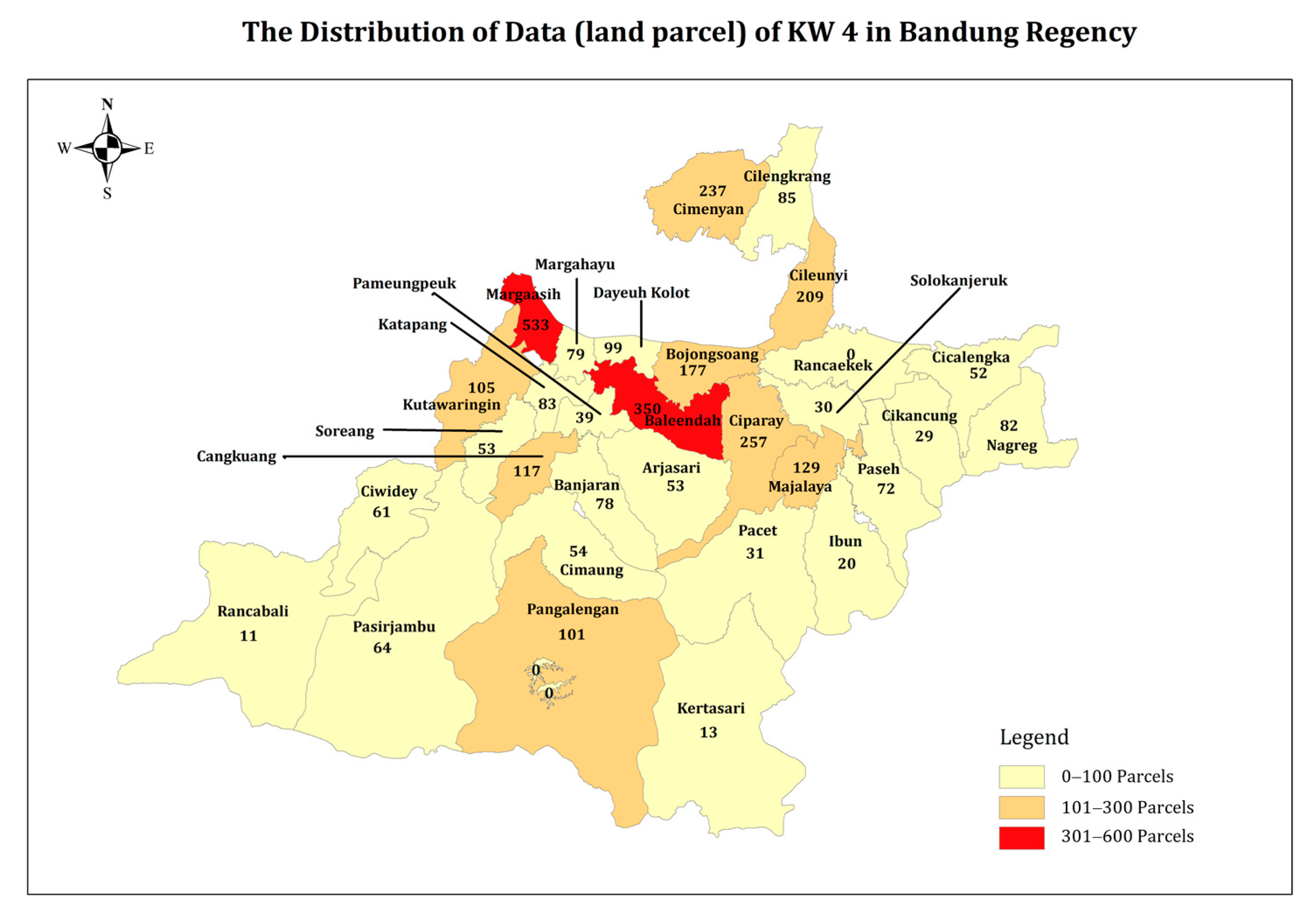
3.1. K-4 Data Sampling Result
3.2. K-4 Typology Model
3.3. Classification Results Based on Typology Type
4. Discussion
4.1. Justification of K-4 Typology to the K-4 Concept of the Ministry of ATR/BPN
4.2. Justification of the K4 Typology to the FFP-LA Concept
4.3. Justification of PESTLE Framework in Data Quality Improvement
5. Conclusions
Author Contributions
Funding
Data Availability Statement
Acknowledgments
Conflicts of Interest
References
- Hidayanti, S.; Koswara, I.; Gunawan, Y. The Land Legal System in Indonesia and Land Rights According to the Basic Agrarian Law (UUPA). Leg. Brief 2021, 11, 366–378. [Google Scholar]
- Nortcliff, S.; Hulpke, H.; Bannick, C.G.; Terytze, K.; Knoop, G.; Bredemeier, M.; Schulte-Bisping, H. Soil, 1. Definition, Function, and Utilization of Soil. In Ullmann’s Encyclopedia of Industrial Chemistry; Wiley Online Library: San Francisco, CA, USA, 2006. [Google Scholar] [CrossRef]
- Liu, M.; Qin, Q.; Zou, Q.; Wang, Y.; Wen, Y. Natural resource dependence of communities around the giant panda protected land based on livelihood capital. Agriculture 2021, 11, 1123. [Google Scholar] [CrossRef]
- Sugiarto, D. Mempercepat Pendaftaran Tanah Di Indonesia Dengan Hukum Pertahanan. Court Rev. J. Penelit. Huk. 2023, 3, 17–21. [Google Scholar]
- Manthovani, R.; Istiqomah, I. Pendaftaran tanah di indonesia. J. Magister Ilmu Huk. 2021, 2, 23–28. [Google Scholar] [CrossRef]
- Ramadhani, R. Pendaftaran tanah sebagai langkah untuk mendapatkan kepastian hukum terhadap hak atas tanah. SOSEK J. Sos. Dan Ekon. 2021, 2, 31–40. [Google Scholar]
- Yubaidi, R.S.; Mohamad, M.; Abd Aziz, S.N. Land Registration Acceleration In Indonesia: A Lesson-Learned Guideline From Land Registration Issues In Malaysia. UUM J. Leg. Stud. 2022, 13, 155–174. [Google Scholar] [CrossRef]
- Perkasa, R.; Lukman, F.A. Pendaftaran Tanah Secara Sporadik Merujuk Kepada PP Nomor 24 Tahun 1997 Tentang Pendaftaran Tanah. JISIP (J. Ilmu Sos. Dan Pendidik.) 2022, 6. [Google Scholar] [CrossRef]
- Rezeki, D.S.; Nasution, A. Tinjauan Yuridis Peralihan Hak Milik Atas Tanah Karena Tukar Menukar Berdasarkan Peraturan Pemerintah Nomor 24 Tahun 1997 Pada Kantor Pertanahan Kota Medan. Mediat. J. Law 2023, 2, 20–30. [Google Scholar]
- Wulansari, H.; Junarto, R.; Mujiburohman, D.A. Mewujudkan sistem pendaftaran tanah publikasi positif. J. Agrar. Dan Pertanah. 2018, 4, 88–101. [Google Scholar] [CrossRef]
- Sumanto, L. The Future on Publication System of Land Registration In Indonesia. Int. J. Sci. Technol. Res. 2020, 9, 1399–1404. [Google Scholar]
- Simarmata, Y.S. Kedudukan Hukum Pihak yang Menguasai Objek Hak Atas Tanah Terkait Proses Peralihan Hak yang Belum Sempurna. Indones. Notary 2021, 3, 1–19. [Google Scholar]
- Ahyani, S. Land Registration as A Legal Construction Of Law In Order to Facing Asean Economic Communities. Int. J. Nusant. Islam 2018, 6, 198–207. [Google Scholar] [CrossRef]
- Charoenkalunyuta, C.M.; Tuladhar, A.; Zevenbergen, J. Community resilience in disaster prone areas based on land rights/ownerships. In 32nd Asian Conference on Remote Sensing 2011, ACRS; National Sun Yat-sen University Press: Kaohsiung, Taiwan, 2011; Volume 1, pp. 556–571. [Google Scholar]
- Permadi, F.B.; Utami, W.; Rokhman, T.N. Collaboration of Three Stakeholders ‘Trisula’ in Realizing the Complete Village Map. J. Sosioteknologi 2021, 20, 210–224. [Google Scholar]
- Kartono, S.A. Politik Hukum Pertanahan Dalam Rangka Percepatan Pendaftaran Tanah Di Indonesia. J. Esensi Huk. 2020, 2, 97–112. [Google Scholar] [CrossRef]
- Ayu, I.K. Problematika Pelaksanaan Pendaftaran Tanah Melalui Pendaftaran Tanah Sistematis Lengkap Di Kota Batu. Leg. J. Ilm. Huk. 2019, 27, 27–40. [Google Scholar] [CrossRef]
- Rahman, D.; Syafari, M.R.; Arbain, T. Kualitas pelayanan program pendaftaran tanah sistematik lengkap di wilayah kantor pertanahan kabupaten Tabalong. PubBis J. Pemikir. Dan Penelit. Adm. Publik Dan Adm. Bisnis 2022, 6, 26–38. [Google Scholar]
- Surianto, M.; Munir, A.M. Strategi Percepatan Pendaftaran Tanah Sistematis Lengkap di Provinsi Kepulauan Riau melalui Pendekatan Analisis Portofolio. J. Pertanah. 2021, 11. [Google Scholar] [CrossRef]
- Marryanti, S.; Purbawa, Y. Optimalisasi faktor–faktor yang mempengaruhi keberhasilan Pendaftaran Tanah Sistematis Lengkap. BHUMI J. Agrar. Dan Pertanah. 2018, 4, 190–207. [Google Scholar] [CrossRef]
- Devi, R.S.; Hutapea, M.M. Tinjauan yuridis terhadap pendaftaran hak atas tanah melalui proyek pendaftaran tanah sistematis lengkap (PTSL) Di Kantor Badan Pertanahan Nasional Kota Medan. J. Rectum Tinj. Yuridis Penanganan Tindak Pidana 2019, 1, 47–86. [Google Scholar]
- Elfani, G.; Adnan, M.F. Evaluasi Pelaksanaan Program Pendaftaran Tanah Sistematis Lengkap Di Kabupaten Sijunjung. JISIP (J. Ilmu Sos. Dan Pendidik.) 2022, 6. [Google Scholar] [CrossRef]
- Sitompul, N.R. Pendaftaran Tanah Yang Tidak Memiliki Alas Hak Melalui Pendaftaran Tanah Sistematis Lengkap. J. Smart Huk. (JSH) 2022, 1, 173–180. [Google Scholar]
- Fitrianingsih, F.; Riyadi, R.; Suharno, S. Evaluasi digitalisasi arsip pertanahan dan peta bidang tanah terintegrasi menuju pelayanan online. Tunas Agrar. 2021, 4, 54–81. [Google Scholar] [CrossRef]
- Suhattanto, M.A.; Sarjita, S.; Sukayadi, S.; Mujiburohman, D.A. Kualitas data pertanahan menuju pelayanan sertifikat tanah elektronik. Widya Bhumi 2021, 1, 87–100. [Google Scholar] [CrossRef]
- Mujiati, M.; Aisiyah, N. Peningkatan kualitas peta kerja dalam pendaftaran tanah sistematis lengkap. Tunas Agrar. 2022, 5, 182–196. [Google Scholar] [CrossRef]
- Chigbu, U.E.; Bendzko, T.; Mabakeng, M.R.; Kuusaana, E.D.; Tutu, D.O. Fit-for-purpose land administration from theory to practice: Three demonstrative case studies of local land administration initiatives in Africa. Land 2021, 10, 476. [Google Scholar] [CrossRef]
- Balas, M.; Carrilho, J.; Lemmen, C. The Fit for Purpose Land 42 Administration Approach-Connecting People, Processes and Technology in Mozambique. Land 2021, 10, 818. [Google Scholar] [CrossRef]
- Rugema, D.M.; Birhanu, T.A.; Shibeshi, G.B. Spatial aspect of fit-for-purpose land administration for emerging land administration systems: A conceptual framework for evaluation approach. Surv. Rev. 2022, 54, 79–92. [Google Scholar] [CrossRef]
- Aditya, T.; Maria-Unger, E.; vd Berg, C.; Bennett, R.; Saers, P.; Lukman Syahid, H.; Sutejo, D. Participatory land administration in Indonesia: Quality and usability assessment. Land 2020, 9, 79. [Google Scholar] [CrossRef]
- Todorovski, D.; Salazar, R.; Jacome, G. Assessment of land administration in Ecuador based on the Fit-for-Purpose approach. Land 2021, 10, 862. [Google Scholar] [CrossRef]
- Metaferia, M.T.; Bennett, R.M.; Alemie, B.K.; Koeva, M. Fit-for-Purpose Land Administration and the Framework for Effective Land Administration: Synthesis of Contemporary Experiences. Land 2022, 12, 58. [Google Scholar] [CrossRef]
- Koeva, M.; Bennett, R.; Persello, C. Remote Sensing for Land Administration 2.0. Remote Sens. 2022, 14, 4359. [Google Scholar] [CrossRef]
- Hernandi, A.; Sella, N.; Alfita, P.; Putri, R.; Winna, P.P.; Lasmi, R.; Rani, A. Incremental Improvement of High resolution Satellite Imagery For Participatory Mapping in Land Registration. IOP Conf. Ser. Earth Environ. Sci. 2019, 280, 012035. [Google Scholar]
- Martono, D.B.; Aditya, T.; Subaryono, S.; Nugroho, P. The legal element of fixing the boundary for indonesian complete cadastre. Land 2021, 10, 49. [Google Scholar] [CrossRef]
- Artika IG, K.; Utami, W. Percepatan pembenahan data bidang tanah kluster 4 melalui survei data pertanahan. BHUMI: J. Agrar. Dan Pertanah. 2020, 6. [Google Scholar] [CrossRef]
- Wijayanto, D.D.; Wahyono, E.B.; Utami, W. Pemanfaatan Unmanned Aerial Vehicle (UAV) untuk Pembenahan Data Spasial Pertanahan (Studi di Desa Karangpakis, Kabupaten Cilacap). Tunas Agrar. 2018, 1. [Google Scholar] [CrossRef]
- Niravita, A.; Wahanisa, R. Tipologi Sengketa Tanah Dan Pilihan Penyelesaiannya (Studi Pada Kantor Pertanahan Kabupaten Semarang). ADHAPER J. Huk. Acara Perdata 2015, 1, 75–85. [Google Scholar]
- Putra, H.S.; Hangabei, S.M.; Ardinata, M.; Dasan, A. Peranan Kantor Pertanahan Kota Bengkulu Sebagai Mediator Dalam Penyelesaian Sengketa Tanah. Al Imarah J. Pemerintah. Dan Polit. Islam 2022, 7, 99–113. [Google Scholar] [CrossRef]
- Sirait, S.Y.; Nazer, M.; Azheri, B. Sertifikasi tanah program pendaftaran tanah sistematis lengkap: Deskripsi dan manfaatnya. BHUMI J. Agrar. Dan Pertanah. 2020, 6, 236–248. [Google Scholar]
- Vardopoulos, I.; Tsilika, E.; Sarantakou, E.; Zorpas, A.A.; Salvati, L.; Tsartas, P. An Integrated SWOT-PESTLE-AHP Model Assessing Sustainability in Adaptive Reuse Projects. Appl. Sci. 2021, 11, 7134. [Google Scholar] [CrossRef]
- Silviana, A. Urgensi Sertipikat Tanah Elektronik Dalam Sistem Hukum Pendaftaran Tanah di Indonesia. Adm. Law Gov. J. 2021, 4, 51–68. [Google Scholar]
- Nuraeni, R.; Sitorus SR, P.; Panuju, D.R. Analisis perubahan penggunaan lahan dan arahan penggunaan lahan wilayah di Kabupaten Bandung. Bul. Tanah Dan Lahan 2017, 1, 79–85. [Google Scholar]
- Anatami, D. Tanggung jawab siapa, bila terjadi sertifikat ganda atas sebidang tanah. J. Huk. Samudra Keadilan 2017, 12, 1–17. [Google Scholar]
- Ramadhan, F.F.; Bintari, A.; Lesmana, A.C. Administrasi Pendaftaran Tanah Kantor Agraria Dan Tata Ruang/Badan Pertanahan Nasional Kota Bandung Untuk Menangani Kasus Sertifikat Ganda Hak Atas Tanah Di Kota Bandung Tahun 2020. J. Adm. Pemerintah. 2022, 2, 55–69. [Google Scholar] [CrossRef]
- Dewi, S.R.; Wulansari, H.; Tilman, A.; Santoso, R.T. Optimalisasi migrasi dan pembaharuan data pertanahan dalam komputerisasi pertanahan di kabupaten Banyuasin. Tunas Agrar. 2022, 5, 211–222. [Google Scholar] [CrossRef]
- Mweshi, G.K.; Sakyi, K. Application of sampling methods for the research design. Arch. Bus. Rev. 2020, 8, 180–193. [Google Scholar] [CrossRef]
- Ismail, I.A.; Pernadi, N.L.; Febriyanti, A. How To Grab And Determine The Size Of The Sample For Research. Int. J. Acad. Appl. Res. (IJAAR) 2022, 6, 88–92. [Google Scholar]
- Muparari, T.; Mbiriri, M.; Dzingirai, M.; Ali, F.; Mugandani, R.; Dewa, F.; Muromo, T. Fit-for-Purpose Land Administration (FFP LA) for Land Tenure Security as a Re-Uniting Tool for International Relations: Bridging LA Researchers in Zimbabwe, the European Union, and the United States of America. Glob. Sci. Coop. Oppor. Chall. Good Pract. 2023, 190–228. [Google Scholar] [CrossRef]
- Hull, S.; Whittal, J. Do Design Science Research and Design Thinking Processes Improve the ‘Fit’of the Fit-For-Purpose Approach to Securing Land Tenure for All in South Africa? Land 2021, 10, 484. [Google Scholar] [CrossRef]
- Musinguzi, M.; Enemark, S.; Kabanda, N.; Antonio, D.; Mwesigye, S.P. Providng Secure Tenure for All: A Country Implementation Strategy for Fit-For-Purpose Land Administration. The case of Uganda. Afr. J. Land Policy Geospat. Sci. 2020, 3, 213–225. [Google Scholar]
- Zalengera, C.; Blanchard, R.E.; Eames, P.C.; Juma, A.M.; Chitawo, M.L.; Gondwe, K.T. Overview of the Malawi energy situation and A PESTLE analysis for sustainable development of renewable energy. Renew. Sustain. Energy Rev. 2014, 38, 335–347. [Google Scholar] [CrossRef]
- Summut-Bonnici, T.; Galea, D. PEST Analysis. In Wiley Encyclopedia of Management; John Wiley & Sons, Ltd.: Hoboken, NJ, USA, 2015. [Google Scholar] [CrossRef]
- Agyekum, E.B. Techno-economic comparative analysis of solar photovoltaic power systems with and without storage systems in three different climatic regions, Ghana. Sustain. Energy Technol. Assess. 2021, 43, 100906. [Google Scholar] [CrossRef]
- ISO 19152:2012; Geographic Information–Land Administration Domain Model (LADM). International Organisation for Standardisation: Geneva, Switzerland, 2012.
- Wiriani, W. Positive Impact of Administrative Modernization in Land in Indonesia. Int. J. Innov. Res. Multidiscip. Educ. 2024, 3, 1037–1040. [Google Scholar]


| Data Availability | Data Quality | |||||
|---|---|---|---|---|---|---|
| K-1 | K-4 | |||||
| KW-1 | KW-2 | KW-3 | KW-4 | KW-5 | KW-6 | |
| Land mapped | V | V | V | X | X | X |
| Spatial of GS/SU | V | X | X | V | X | X |
| Textual of GS/SU | V | V | X | V | V | X |
| Land ownership book | V | V | V | V | V | V |
| Aspect | Impact in the Decision Making |
|---|---|
| Political | Political conditions of a nation that suffers substantial transformations affect the composition and operations of institutions. Consistency between organizational strategies and prevailing policies can be achieved by consistently monitoring the political climate [53]. |
| Economic | The process of identifying crucial economic aspects that directly influence decision making for investors and the government will be beneficial [53]. The observed economic aspects prioritize concerns that have an immediate impact, rather than addressing broader spectrum issues. |
| Social | Monitoring the social environment of a country enables the anticipation of potential influences from different stakeholders on government policy actions [53]. |
| Technology | Technological progress can enhance efficiency and cost-effectiveness [53]. |
| Legal | This factor examines the impact of policies and legislation on the industry/organization and formulates strategies accordingly [54]. |
| Environmental | The environmental aspect is vital in project development and management. The factors discussed in this part have the potential to impact the overall efficiency of the project, and it is important to thoroughly investigate these factors [54]. |
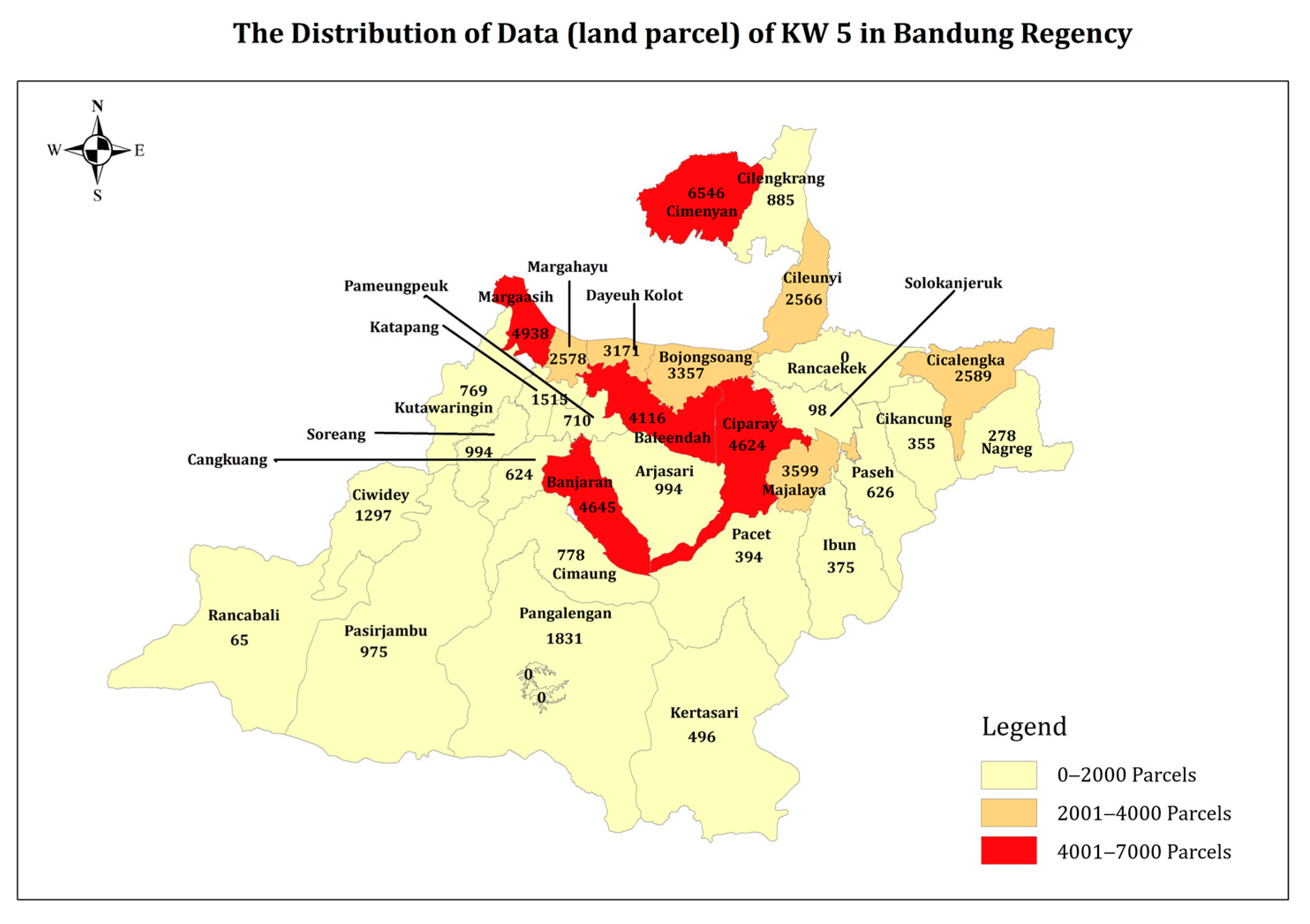
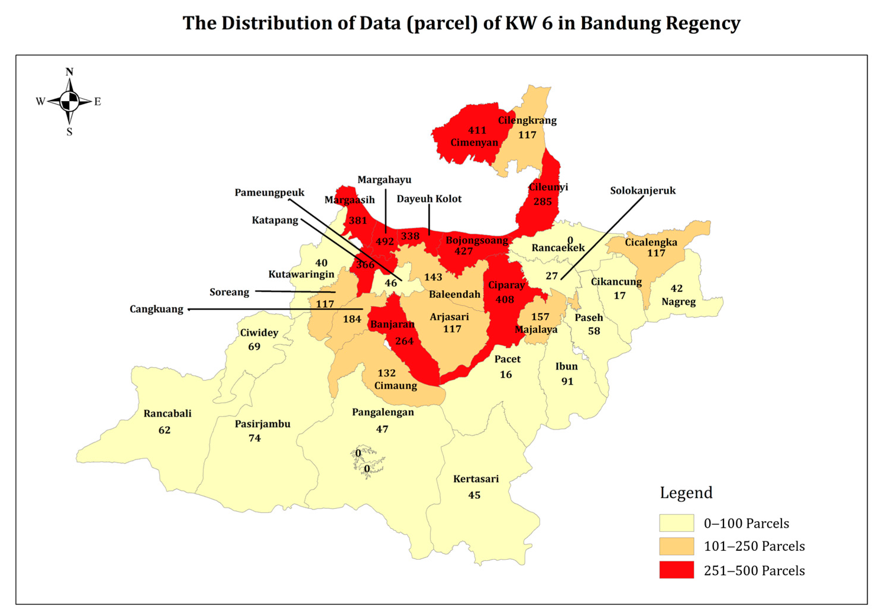
| Sub-District | Total Data | Village | Sample | ||
|---|---|---|---|---|---|
| KW-4 | KW-5 | KW-6 | |||
| Arjasari | 53 | 994 | 117 | Wargaluyu | 7 |
| Baleendah | 350 | 4116 | 143 | Baleendah | 6 |
| Jelekong | 6 | ||||
| Manggahang | 6 | ||||
| Rancamanyar | 6 | ||||
| Bojongsoang | 177 | 3357 | 427 | Tegalluar | 22 |
| Cangkuang | 117 | 624 | 184 | Bandasari | 3 |
| Ciluncat | 2 | ||||
| Cikancung | 29 | 355 | 17 | Ciluluk | 2 |
| Cikasungka | 2 | ||||
| Ciwidey | 61 | 1297 | 69 | Panyocokan | 9 |
| Katapang | 83 | 1515 | 366 | Pangauban | 3 |
| Banyusari | 3 | ||||
| Katapang | 3 | ||||
| Sukamukti | 3 | ||||
| Soreang | 102 | 1746 | 251 | Pamekaran | 13 |
| Total | 972 | 14004 | 1574 | 96 | |
| Type of Typology | Data Availability Criteria | ||||||
|---|---|---|---|---|---|---|---|
| Physical GU | Spatial Physical GS/SU | Spatial Digital GS/SU | Textual Physical GS/SU | Textual Digital GS/SU | Land Ownership Book Physical | Land Ownership Book Digital | |
| T1 | 0 | 0 | 0 | 0 | 0 | 0 | 0 |
| T2 | 1 | 0 | 0 | 0 | 0 | 0 | 0 |
| T3 | 0 | 1 | 0 | 0 | 0 | 0 | 0 |
| T4 | 1 | 1 | 0 | 0 | 0 | 0 | 0 |
| T5 | 0 | 0 | 1 | 0 | 0 | 0 | 0 |
| . | . | . | . | . | . | . | . |
| . | . | . | . | . | . | . | . |
| . | . | . | . | . | . | . | . |
| T43 | 0 | 1 | 0 | 1 | 0 | 1 | 0 |
| . | . | . | . | . | . | . | . |
| . | . | . | . | . | . | . | . |
| . | . | . | . | . | . | . | . |
| T63 | 0 | 1 | 1 | 1 | 1 | 1 | 0 |
| . | . | . | . | . | . | . | . |
| . | . | . | . | . | . | . | . |
| . | . | . | . | . | . | . | . |
| T128 | 1 | 1 | 1 | 1 | 1 | 1 | 1 |
| Sub-District | Village | Typology Class | |||
|---|---|---|---|---|---|
| T1 | T43 | T63 | T128 | ||
| Arjasari | Wargaluyu | 1 | 1 | 0 | 5 |
| Baleendah | Baleendah | 0 | 6 | 0 | 0 |
| Jelekong | 0 | 0 | 0 | 6 | |
| Manggahang | 4 | 0 | 0 | 2 | |
| Rancamanyar | 0 | 6 | 0 | 0 | |
| Bojongsoang | Tegalluar | 3 | 1 | 0 | 18 |
| Cangkuang | Bandasari | 1 | 1 | 0 | 1 |
| Ciluncat | 0 | 0 | 0 | 2 | |
| Cikancung | Ciluluk | 0 | 0 | 0 | 2 |
| Cikasungka | 0 | 0 | 0 | 2 | |
| Ciwidey | Panyocokan | 0 | 0 | 0 | 9 |
| Katapang | Pangauban | 0 | 0 | 0 | 3 |
| Banyusari | 0 | 0 | 0 | 3 | |
| Katapang | 0 | 0 | 0 | 3 | |
| Sukamukti | 0 | 0 | 0 | 3 | |
| Soreang | Pamekaran | 3 | 2 | 1 | 7 |
| Total | 12 | 17 | 1 | 66 | |
| Data Availability | Physical GU | Spatial Physical GS/SU | Spatial Digital GS/SU | Textual Physical GS/SU | Textual Digital GS/SU | Land Ownership Book Physical | Land Ownership Book Digital |
|---|---|---|---|---|---|---|---|
| KW-4 | Not available | Not identified physical or digital data | Not identified physical or digital data | Not identified physical or digital data | |||
| KW-5 | Not available | Not available | Not available | Not identified physical or digital data | Not identified physical or digital data | ||
| KW-6 | Not available | Not available | Not available | Not available | Not available | Not identified physical or digital data | |
| T1 | Not available | Not available | Not available | Not available | Not available | Not available | Not available |
| T43 | Not available | Available | Not available | Available | Not available | Available | Not available |
| T63 | Not available | Available | Available | Available | Available | Available | Available |
| T128 | Available | Available | Available | Available | Available | Available | Available |
| No | K-4 Typology | Identification Problem | |||
|---|---|---|---|---|---|
| Cluster | Data Availability | Spatial Framework | Law Framework | Institutional Framework | |
| 1 | T1 | Not available for all criteria data | Borderline point is not available; document/ownership evidence is not available; land registration mapping is not satisfied; landscape is change/lost; Area expansion | Document/ownership evidence is not available; conflict | Inadequate human resource and facilities; bureaucratic obstacles |
| 2 | T43 | Data available: spatial physical GS/SU, textual physical GS/SU, land ownership book physical | Borderline point is not available, document/ownership evidence is not available; area expansion | Document/ownership evidence is not available; conflict | Inadequate human resource and facilities; bureaucratic obstacles. |
| 3 | T63 | Data available: spatial physical GS/SU, spatial digital GS/SU, textual physical GS/SU, textual digital GS/SU, land ownership book physical | Borderline point is not available, document/ownership evidence is not available; area expansion | Document/ownership evidence is not available; conflict | Inadequate human resource and facilities; bureaucratic obstacles |
| 4 | T128 | Available for all criteria data | Inadequate human resource and facilities; bureaucratic obstacles | ||
| No. | Category | Factor |
|---|---|---|
| 1 | Political | The President of Indonesia’s directives to implement the nationwide land certification program; towards complete cities/districts; influence of stakeholders. |
| 2 | Economic | Increase in investors entering Indonesia; growth of Indonesia’s Gross Domestic Regional Product (PDRB); promoting access reform for MSME development. |
| 3 | Sociological | Integrity of the Ministry of Agrarian Affairs and Spatial Planning (ATR/BPN) and its affiliates in the public eye; achieving the WBK and WBBM predicate for all offices in the Ministry of Agrarian Affairs and Spatial Planning; public enthusiasm to participate in the PTSL program. |
| 4 | Technological | Digitization of land data; towards electronic land certificates; ease of access to information for the public. |
| 5 | Legal | Resolving land certificate issuance issues; preventing actions by land mafias; towards a positive land registration system. |
| 6 | Environmental | Based on decision-making tools for spatial and territorial regulation design; supporting go green initiatives by reducing paper usage in physical land data. |
Disclaimer/Publisher’s Note: The statements, opinions and data contained in all publications are solely those of the individual author(s) and contributor(s) and not of MDPI and/or the editor(s). MDPI and/or the editor(s) disclaim responsibility for any injury to people or property resulting from any ideas, methods, instructions or products referred to in the content. |
© 2024 by the authors. Licensee MDPI, Basel, Switzerland. This article is an open access article distributed under the terms and conditions of the Creative Commons Attribution (CC BY) license (https://creativecommons.org/licenses/by/4.0/).
Share and Cite
Huda, N.; Hernandi, A.; Gumilar, I.; Meilano, I.; Cahyaningtyas, L.A. The Strategic Development of Quality Improvement Land Data Incrementally Using Integrated PESTEL and SWOT Analysis in Indonesia. Land 2024, 13, 1655. https://doi.org/10.3390/land13101655
Huda N, Hernandi A, Gumilar I, Meilano I, Cahyaningtyas LA. The Strategic Development of Quality Improvement Land Data Incrementally Using Integrated PESTEL and SWOT Analysis in Indonesia. Land. 2024; 13(10):1655. https://doi.org/10.3390/land13101655
Chicago/Turabian StyleHuda, Nurul, Andri Hernandi, Irwan Gumilar, Irwan Meilano, and Lisa A. Cahyaningtyas. 2024. "The Strategic Development of Quality Improvement Land Data Incrementally Using Integrated PESTEL and SWOT Analysis in Indonesia" Land 13, no. 10: 1655. https://doi.org/10.3390/land13101655
APA StyleHuda, N., Hernandi, A., Gumilar, I., Meilano, I., & Cahyaningtyas, L. A. (2024). The Strategic Development of Quality Improvement Land Data Incrementally Using Integrated PESTEL and SWOT Analysis in Indonesia. Land, 13(10), 1655. https://doi.org/10.3390/land13101655