Abstract
Land registration is an important program in asset legalization with the vast land resources owned by Indonesia. The reality is that there are 48 million certificated lands out of an estimated 126 million certificates throughout Indonesia, so the Ministry of Agrarian Affairs and Spatial Planning/National Land Agency (ATR/BPN) made a breakthrough through the Complete Systematic Land Registration (PTSL) program. The grouping mechanism of the PTSL program is divided into four clusters, namely K-1, K-2, K-3, and K-4. Land parcels included in K-4 have problems, namely that they have been registered but not mapped/mapped incorrectly, so the idea of modeling the K-4 typology is needed for accelerating the improvement in land data quality (KW). The research location is in Bandung Regency, which is included in the top five land offices with the highest number of K-4 in West Java Province. This research method uses a mixed method, namely quantitative with a Slovin approach for the identification and clustering of K-4 typology and descriptive qualitative for justification of typology modeling in multiple aspects. The results of K-4 typology modeling were 128 clusters based on seven types of data criteria and obtained 4 clusters that matched the data sample, namely T-1, T-43, T-63, and T-128. The four clusters were justified against the K-4 concept in the Ministry of ATR/BPN, the FFP-LA concept, and the PESTLE framework. Dissemination of K-4 typology modeling is a breakthrough that can be implemented by the Ministry of ATR/BPN and its staff in various regions and the role of multi-concepts in this research can be an input for improving the K-4 concept that has been in effect so far.
1. Introduction
Indonesia is an agrarian country, with land resources serving as national and societal assets [1,2,3]. Land is crucial in various sectors, including the economy, society, culture, defense, and other areas [4,5]. Given the diverse range of stakeholders with varying interests in land requirements, it is necessary to implement sustainable land administration management. Indonesia has fulfilled this requirement by enacting a variety of legislation, including laws and government regulations that comprehensively cover both the theoretical and practical aspects of land registration [6,7,8,9].
Land registration in Indonesia is regulated by laws and government regulations. The general provisions regarding land rights and land registration are outlined in Law Number 5 of 1960 concerning the Basic Agrarian Law. The main guidelines for the implementation of land registration in Indonesia, including the procedures and requirements for land registration, are regulated in Government Regulation Number 24 of 1997 concerning Land Registration. Land registration programs in Indonesia include the National Agrarian Operations Project (PRONA) in 1981, the National First-Time Land Registration Project (Larasita Project/Public Service for Land Certification) in 2007, the Land Administration Project (LAP) from 1994 to 2001, the Systematic Land Titling (SLT) Project, and the Land Redistribution Project under Agrarian Reform. Land registration in Indonesia was generally carried out sporadically, based on applications from individuals or groups, a system considered slow, with limited coverage and longer processing times. Subsequently, in 2017, the government, through the Ministry of Agrarian Affairs and Spatial Planning/National Land Agency (ATR/BPN), launched the Complete Systematic Land Registration Program (PTSL). In 2018, through Presidential Regulation Number 86 of 2018, it regulated the Acceleration of Complete Systematic Land Registration (PTSL) and mandated that all land in Indonesia must be registered by 2025.
The Ministry of Agrarian and Spatial Planning/National Land Agency (ATR/BPN), leading the Indonesian government, has initiated a land registration initiative to achieve nationwide land certification [10]. This program has attracted considerable interest due to its ability to offer several advantages, such as legal certainty regarding land title, elimination of land mafias, and reduction in land disputes, conflicts, and cases (LDCC) [6,11,12]. The registration of all land parcels will be a part of the government’s efforts to effectively manage land possession, ownership, use, and utilization (P4T) and create a favorable environment for investment [13,14,15]. Only around 48 million of Indonesia’s 126 million land pieces currently hold certification. It would take nearly 60 years to certify all of the land parcels in the country [16,17].
Land registration activities that have been carried out since 1955 have not been optimally implemented. This is evident from the 2018 performance report of the Ministry of Agrarian Affairs and Spatial Planning/National Land Agency (ATR/BPN), which revealed that out of more than 126 million land parcels spread across the territory of the Republic of Indonesia, there are still 86 million parcels that have not been registered or certified. This means that in the 63 years since land registration began, only about 44% of land parcels have been registered.
The large number of unregistered or uncertified land parcels has resulted in the ATR/BPN Ministry not having a complete, accurate, and structured land database [18]. Additionally, the high number of unregistered land parcels has led to an increase in land disputes, conflicts, and cases in Indonesia, high levels of overlapping land ownership and control [15], land ownership inequality, and a lack of clarity regarding land rights.
The Ministry of ATR/BPN initiated the Complete Systematic Land Registration Program (PTSL) in response. The Complete Systematic Land Registration (PTSL) is the process of registering land for the first time, which is carried out simultaneously and covers all land registration objects that have not yet been registered within a village or sub-district area, or other similar administrative divisions [1]. The program is outlined in the Regulation of the Minister of Agrarian Affairs and Spatial Planning/Head of the National Land Agency of the Republic of Indonesia Number 12 of 2017 concerning Complete Systematic Land Registration. The objectives of PTSL include realizing tangible development for Indonesia and ensuring that certificate recipients are accurately targeted, enabling communities to begin improving their quality of life. PTSL is conducted to obtain legal certainty for land rights holders as well as other parties with an interest in the land they control [18]. Additionally, it aims to establish an orderly land administration system. The program’s gravity is apparent from registering 5 million land parcels in 2017, 7 million in 2018, and 9 million in 2019. The program aims to register 10 million land parcels annually until all parcels receive certification by 2025 [19,20].
Four main categories comprise the practitioner mechanism in the PTSL program: land parcels ready for certification (K-1), disputed land parcels (K-2), land parcels with uncertified physical or juridical data due to subject or object reasons (K-3), and land parcels already certified for quality improvement (K-4) [21,22]. The Computerized Land Office (KKP) system needs to be improved in mapping 15 million of the total 48 million registered land parcels [23,24]. Duplicate numbering, the absence of Situational/Measurement Sketch (GS/SU) data, the lack of parcel identification numbers (NIB), and a previous manual archive inventory all contribute to the current issue. References [17,25] have identified these factors. The Ministry of ATR/BPN is highly concerned about enhancing the quality of the land data it currently holds [26,27].
To enhance the accuracy of land data, it is necessary to develop a land registration concept tailored to Indonesia’s specific circumstances. Several nations have implemented the Fit-for-Purpose Land Administration (FFP-LA) framework, which is well-known for its benefits in terms of land management efficiency, reduced time, cost-effectiveness, and improved collaboration among stakeholders [28,29,30]. The Ministry of ATR/BPN has unquestionably applied this approach to accelerate land registration and improve the accuracy of land data [31]. The FFP-LA idea comprises three primary frameworks: geographical, legal, and institutional [32,33]. This concept is only partially consistent with the actuality of enhancing data quality. Initially, FFP-LA suggests using remote sensing and general boundary techniques for parcel mapping to establish the spatial framework [34,35]. However, the Ministry of ATR/BPN insists on the necessity of field measurements and established boundaries [36]. Furthermore, the focus on enhancing data quality remains solely on the geographical framework. The Ministry of ATR/BPN has recently enhanced its measurement and mapping capabilities, improving spatial data [17,37,38].
In order to expedite and enhance the accuracy of land data, we require an innovative concept to revise the K-4 typology modeling, drawing upon prior research and present circumstances. The existing K-4 is limited to the classification based on the 2022 technical guidelines for PTSL, where the data availability components include only four parameters: mapped land parcels, GS/SU Spatial, GS/SU Textual, and Land Books. In the implementation of PTSL activities, data quality is not separated based on whether the data are analog or digital. Digital land data have significant advantages over analog land data, including efficiency in management and accessibility of information. With digital technology, data can be stored, processed, and analyzed much faster, allowing users to easily obtain accurate and up-to-date information. Furthermore, digital data reduce the risk of loss or damage to information, which often occurs with physical documents, and allows integration with more advanced mapping systems for spatial analysis. Another advantage is the ease of updating data, making land data more responsive to change occurring in the field. Therefore, in this study, the distinction between digital and analog data is an important consideration in developing a typology of land data quality. As a result of this review, the data availability components have been expanded from four parameters to seven, by separating analog and digital data, which now include: Physical Land Books; Digital Land Books; Physical GS/SU Spatial; Digital GS/SU Spatial; Physical GS/SU Textual; Digital GS/SU Textual; and Physical Survey Sketch (GU). Indonesian land activities commonly use typology concepts, particularly in land conflicts [39,40]. This research is groundbreaking as it delves into typology modeling to improve the quality of K-4 data. Using the PESTLE analysis, which provides a broader context and identifies specific influencing factors in a comprehensive manner. PESTLE analysis is a method for analyzing factors that affect an organization by dividing them into political, economic, social, technological, legal, and environmental aspects [41]. The Ministry of ATR/BPN and its affiliates have not addressed this topic in previous studies. The typology concept is also in collaboration with the FFP-LA concept to establish its rationale for implementation in Indonesia. Undoubtedly, the enhancement of land data quality will result in the availability of electronic-ready data by 2025 [42,43].
2. Methods
2.1. Study Area
We conducted research on K-4 in Bandung Regency, West Java Province. Bandung Regency is adjacent to Bandung City, which is experiencing highly dynamic territorial development as the capital of West Java Province [44]. This has led to high land values in Bandung Regency, increasing the risk of land conflicts [45]. Additionally, the condition of K-4 land parcels with invalid data can lead to issues such as cases of duplicate certificates for a single land parcel, as seen in Bandung Regency [46,47]. In 2022, there were a total of 71,068 K-4 data entries that needed quality improvement. This number places Bandung Regency among the top five regions with the highest number of K-4 entries in West Java. This research focused on 16 villages/sub-districts that were the target of the PTSL program in 2022. Figure 1 shows the distribution of these target villages for the PTSL 2022 program in Bandung Regency, the study’s location.
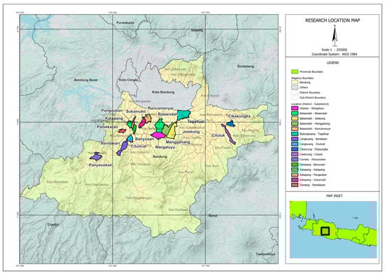
Figure 1.
Research study location.
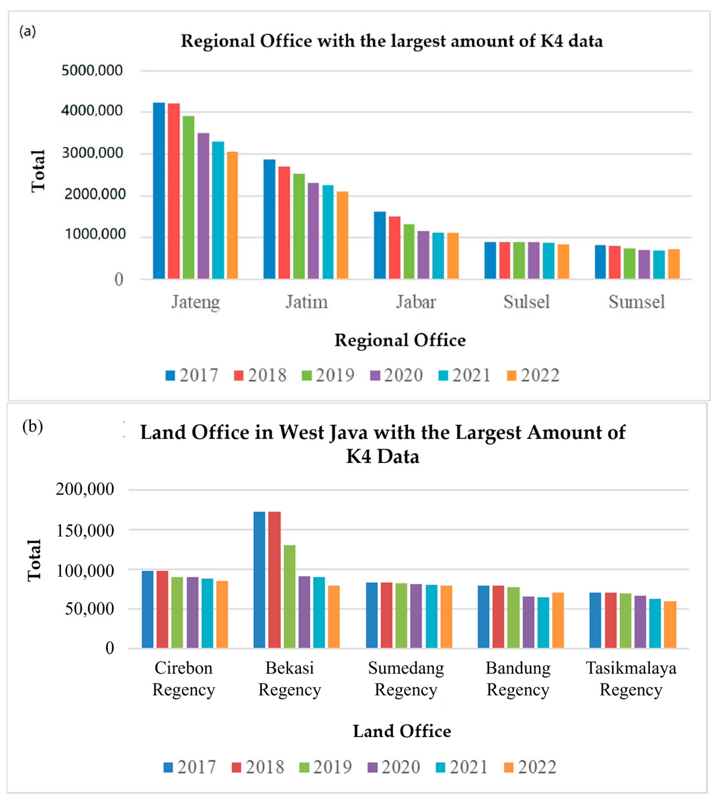
Thus, the availability of the land database needs to be improved. From 2017 to 2022, the West Java Regional Office consistently ranked 3rd in terms of the largest amount of K-4 data. At the city/regency level, Bandung Regency is among the top 5 with the most K-4 data in West Java. This issue needs to be addressed promptly by the Ministry of ATR/BPN through accelerated efforts to improve data quality.
The graph in Figure 2 shows that the Land Office of Bandung Regency is among the top 5 land offices with the largest amount of K-4 data in West Java. In 2022, there were a total of 71,068 K-4 data entries that need to be improved in terms of quality.
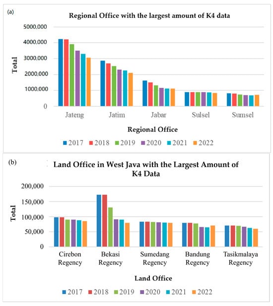
Figure 2.
(a) Regional office with the largest amount of K4 data; (b) land office in West Java with the largest amount of K4 data.
2.2. Research Method
This study aims to typologize the sample data of K-4 land parcels and modify models to develop a resolution method from the perspective of FFP-LA as shown in the research method flowchart (see Figure 3). This study employs a quantitative method to assess the completeness of data from K-4 land parcels, sampling based on the Slovin method in the target villages for the PTSL 2022 program in Bandung Regency. The Land Office of Bandung Regency served as the data sampling source, ensuring the completeness of K-4 land parcels. The selection of Bandung Regency as the data sampling location was based on several considerations. First, Bandung Regency has a wide variety of land data, covering various types of land use such as residential, agricultural, and commercial. This provides an opportunity to analyze different aspects related to the PTSL program. Second, the high demand for land legality in Bandung Regency is also an important consideration, given the large number of land disputes that occur. Third, the support from the local government for the PTSL program, demonstrated through efforts and policies aimed at the success of the program, makes this location more attractive for research. Specific criteria used in selecting Bandung Regency include the high population growth rate, the high level of urbanization, and the complex land ownership issues present. The sampling of K–4 land parcel data aims to identify their typologies. The conducted qualitative method aims to model resolution strategies for K–4 by implementing FFP-LA based on the typology results. We also consider political, economic, social, technological, policy, and environmental aspects when designing strategies, drawing on PESTLE analysis.
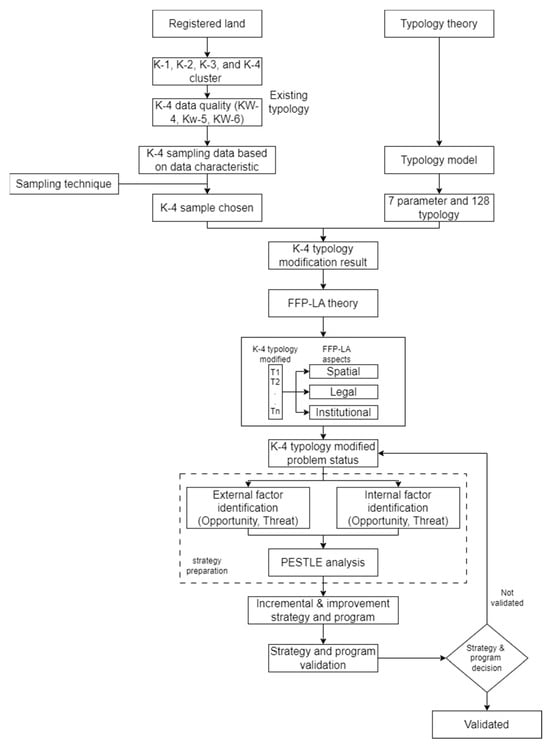
Figure 3.
Research method flowchart.
2.3. PTSL Clustering and Land Data Quality
Reference [22] defines the PTSL as a comprehensive land registration procedure encompassing all unregistered land parcels within a village, sub-district, or similar jurisdiction. Stakeholders in Indonesia launched the PTSL initiative to expedite land registration. Sporadic land registration results in substantial expenses and consumes much time [22]. The PTSL activities yield data that categorize land parcels into four distinct output groups. In 2023, the Ministry of ATR/BPN defined four distinct groupings. There are four clusters: Cluster 1 (K-1) contains physical and legal data that fulfil the criteria for issuing certificates; cluster 2 (K-2) does not meet the requirements due to ongoing court cases or disputes; cluster 3 (K-3) is not eligible due to limitations on subjects and objects; and cluster 4 (K-4) consists of land parcels that have been certified but have not yet been mapped into the system.
A plot of land categorized as K-2 refers to land in dispute, particularly related to ownership evidence due to the conversion of old land ownership proof (such as detail, girik, ketitir, pipil, and vervonding Indonesia). As a result, old ownership documents are no longer recognized as legal proof of land ownership, but rather as evidence of managing land rights in accordance with Law Number 12 of 1985 on Land and Building Tax (PBB). Land disputes may also arise due to disagreements over land boundaries. Despite regulations on land registration, in reality, many individuals take advantage of weaknesses in law enforcement, leading to an increase in the number of land disputes. Land disputes are a global issue occurring in various countries, each with its own background, context, and dynamics.
K-4 land parcels are groups of land that already possess HAT-certified titles and can potentially result in land conflicts if left unresolved. The K4 land parcels, namely KW-4, KW-5, and KW-6, must enhance their data quality in order to be recognized as genuine land parcel data, namely KW-1, KW-2, and KW-3 [17]. Table 1 presents a comprehensive elucidation of the quality of land data.

Table 1.
The quality of land data classification (Source: Kementerian ATR/BPN, 2022).
2.4. K-4 Typology
The classification of K-4 data relies on the availability of data, and this research developed a typology based on the presence or absence of specific types of data. The typology relies on the combinatorial calculation of the completeness of existing data in the K-4 dataset. Combinatorial is a branch of mathematics for calculating the number of arrangements of objects in a set and to determine the number of possibilities within a set or event. The data needed to complete K-4 can have two possibilities: existing and non-existent. The typology method to account for this possibility employs the following formula:
where N is the number of data in K-4.
By establishing a typology model according to the criteria for the type of data needed to improve K-4 data, this study accomplishes this. In addition to physical BT and digital BT, seven data type criteria must be satisfied: (4) digital spatial GS/SU; (5) physical textual GS/SU; (6) digital textual GS/SU; and (7) physical GU.
2.5. Sampling Technique
We used the quota sampling technique and determined the sample size using the Slovin method. Reference [47] employs the Slovin approach as a statistical strategy to determine the necessary sample size for a study involving a sizable population. This approach utilizes a standardized mathematical formula to calculate the required sample size from the population [48]. The Slovin method has advantages in its simplicity and ease of use, allowing researchers to determine a representative sample size without requiring deep statistical knowledge. This method also helps reduce bias and allows for time and cost savings in data collection. However, the weaknesses of this method include the assumption that the population has a normal distribution, which is not always the case, as well as the potential to overlook variability within the population, which can lead to results that do not encompass key groups. Additionally, in very large populations, the sample size determined may not be sufficient for more in-depth analysis. Numerous studies consider using the Slovin approach with a 5% margin of error to be reliable. We subsequently allocated the acquired sample size to the number of KW-4, KW-5, and KW-6 in each target village for the PTSL 2022 program. The determination of the sample size is elucidated using the Slovin formula as:
where n is number of samples, N is number of population, and e is an error threshold which is 5%.
There are 31 sub-districts in Bandung Regency. Furthermore, Bandung Regency also has 10 urban villages and 270 rural villages. Therefore, the population data for land parcels in the PTSL locations amount to 66,122 land parcels, which are normally distributed as shown in Figure 4, Figure 5 and Figure 6. These large population data allow the Slovin method to be used effectively. The following presents the data distribution of KW-4, KW-5, and KW-6 in Bandung Regency, sourced from KKP ATR/BPN Data 2023.

Figure 4.
Data distribution of KW-4 in Bandung Regency.
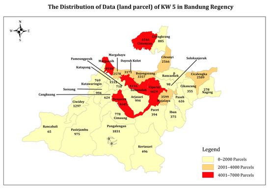
Figure 5.
Data distribution of KW-5 in Bandung Regency.
Figure 6.
Data distribution of KW-6 in Bandung Regency.
2.6. FFP-LA Concept
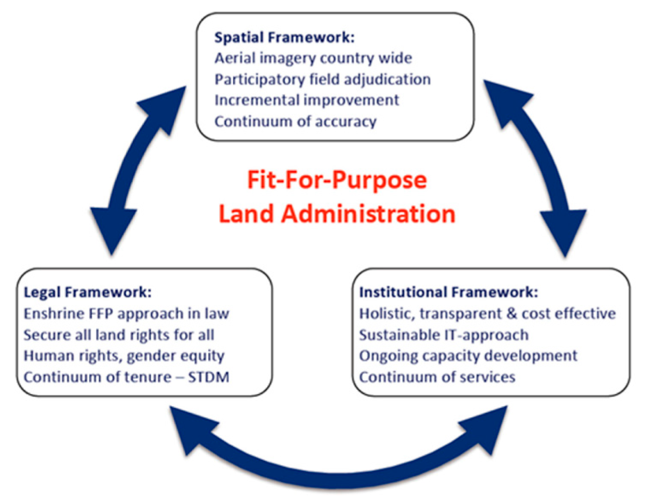
FFP-LA is a methodology employed to attain specific goals in land administration through a more adaptable approach, prioritizing outcome-driven excellence rather than technical specifications [34]. The FFP-LA idea is highly beneficial for tackling land administration difficulties in poor nations [27]. As described in Figure 7, the FFP-LA framework is characterized by three fundamental principles: the spatial framework, the legal framework, and the institutional framework. The FFP-LA idea has been extensively utilized in land administration solutions across multiple nations [49,50,51]. This study utilizes the FFP-LA framework to provide solutions to enhance data quality by analyzing K-4 data typology findings.

Figure 7.
The concept of FFP-LA [51].
2.7. PESTLE Framework
The PESTLE analysis is a framework used to assess the impact of political (P), economic (E), social (S), technical (T), legal (L), and environmental (E) aspects on an organization [52]. Unlike SWOT analysis, which identifies aspects in a broad sense, PESTLE analysis recognizes components with precise dimensions. The utilization of PESTLE analysis by several institutions to assess organizational performance has been documented. This K-4 study employs PESTLE analysis as it comprehensively assesses specific influencing elements within a broader framework [41]. There has been no research on the development of land data typology (K4) that connects it with the FFP-LA framework, followed by the creation of strategies to solve it through the SWOT-PESTEL approach. A similar study [35] is about “Cadastre Typology as a Baseline for Incremental Improvement of Spatial Cadastre in Jakarta: Towards a Complete Cadastre” This paper discusses cadastre typology but does not address K4 typology. Meanwhile, the existing typology has already been explained in the PTSL 2022 technical guidelines. However, these guidelines do not differentiate data quality based on whether the data are analog or digital. Table 2 highlights the utilization of the PESTLE framework for problem analysis.
Table 2.
PESTLE framework.
3. Results
3.1. K-4 Data Sampling Result
The sample size was determined to be 398 using the Slovin formula, which accounts for a 5% margin of error—additional computations with the weighting technique generated samples for each KW-4, KW-5, and KW-6 data category. The weighting for KW-4 and KW-6 was determined using classes based on the sample data, which spanned from the lowest to the most significant values. The difference between these values was then calculated. Subsequently, the intervals for each class were determined by performing a division operation with a factor of 3. The ordered list of classes 1, 2, and 3 corresponds to the ascending order of their ranges, from the lowest to the highest. The total data for each range were calculated by multiplying the weight by the number of data points, resulting in 36 KW-4 and 48 KW-6 data points. The KW-5 samples were derived by subtracting the total count from the KW-4 and KW-6 samples. The weighting for KW-5 was calculated by dividing the number of KW-5 per district by the total KW-5 for the district and then multiplying it by the KW-5 sample. The sample size for KW-4 and KW-6 in each district was established using the results of a weighted computation. After receiving the sample results for each district, the data volume was reduced by focusing on the 16 villages included in the PTSL program 2022. The sample selection for each village was determined by dividing the results of each district by the number of villages in each district. Therefore, the whole sample size amounted to 96. Table 3 summarizes the sample results.
Table 3.
Number of samples.
3.2. K-4 Typology Model
The typology model, which categorizes data quality based on the seven data types, yielded 128 classifications. These classes represent all possible combinations of data complete requirements for K-4. The 128 classifications are derived from the calculation of 2^n, where n represents the number of circumstances. In this case, there are two conditions: data accessible or not available. These conditions result in the combination of possibilities, further influenced by the seven levels of data completeness. The typology modeling of K-4 is explained in the subsequent model. Table 4 represents data availability with the number 1 and data unavailability with the number 0. T-1, where all data completeness is shown by 0, signifies that none of the seven data parameters are accessible. Meanwhile, in typology T-128, when all the number are one, this indicates complete data.
Table 4.
K-4 typology modelling.
3.3. Classification Results Based on Typology Type
The K-4 classification was applied to 96 samples, resulting in four main types of classifications (see Table 5). The findings revealed a clear tendency towards classification into T-1, T-48, T-63, and T-128, indicating a high level of homogeneity in the completeness of K-4 data conditions for these classifications. Typology T-1, representing the unavailability of the completeness of all seven data conditions, was identified in 12 instances, indicating that all required documents are either missing or no longer identified. Typology T-43, indicating the availability of three specific data types, amounted to 17 instances, representing a condition where the available documents are physical and yet to be digitized. Typology T-63 indicates that only two complete data types are unavailable, amounting to one instance. In typology T-63, Physical GU is unavailable, although it can help identify the location of land parcels. T-128, where all seven data types are complete, amounted to 66 instances. Typologies T-1 and T-43 are not evenly distributed across the 16 target villages of the PTSL. At the same time, typology T-128, where all data types are complete, has the most significant number and is evenly distributed across the 16 villages. Considering the variation in K-4 typologies, the village of Pamekaran, Soreang District, has four types of K-4 problem typologies.
Table 5.
Number of sampling data based on typology class.
4. Discussion
4.1. Justification of K-4 Typology to the K-4 Concept of the Ministry of ATR/BPN
K-4 is related to identifying KW-4, KW-5, and KW-6. The K-4 typology criteria in this study are contrasted with the KW criteria, as illustrated in Table 6. Firstly, the KW data in K-4, as per the Ministry of ATR/BPN’s idea, need to consider the availability of physical GU data. On the other hand, the K-4 typology incorporates these data, which are closely linked to evidence from field surveys. Furthermore, the KW concept in K-4 must adequately distinguish between physical and digital spatial GS/SU data, physical and digital textual GS/SU data, and physical and digital land data. Utilizing the K-4 typology, this approach involves segregating and categorizing all forms of data, including physical and digital, to provide comprehensive and intricate data accessibility. It is crucial to prioritize acquiring physical GU data, physical spatial and textual GS/SU data, and physical land data to ensure the proper storage of hard copies. Physical data are the foundation for cataloging outdated data managed manually due to insufficient technology. Maintaining data on land parcels began in 1960 following the implementation of Law Number 5 of 1960, which marked the commencement of land registration activities. Physical data act as a point of reference for historical land parcel mapping and as compelling evidence of land ownership by ensuring the accuracy and integrity of recorded legal data. Indeed, the KKP system is utilized to convert the information stored in physical data into digital data.
Table 6.
Identification of K-4 typology data type criteria for the K-4 concept in the Ministry of ATR/BPN.
Moreover, the need for digital spatial and textual GS/SU data and land data is also a crucial priority in K-4 typology. The Ministry of ATR/BPN embraces technological innovations to enhance its computerized data management. The presence of digital data serves as concrete evidence that physical data have been converted into a digital format within the KKP system. This offers several benefits, including streamlining data management, mitigating the risk of physical data loss caused by calamities, decreasing duplicate land data, and cutting down on data maintenance expenses. A disparity exists between the data captured in physical form and recorded digitally, which can be attributed to geographical units (GU), ground stations/satellite units (GS/SU), and land data. The K-4 typology is the optimal approach for distinguishing and managing intricate and comprehensive data. It allows for segregating GU data, geographical and textual GS/SU, and physical and digital land data, essential for resolving K-4 issues. The comprehensive data availability implemented through the K04 typology concept will not provide challenges for field implementers in land agencies to locate data; instead, it will facilitate the identification of data kinds that are currently deficient in the data quality enhancement process.
4.2. Justification of the K4 Typology to the FFP-LA Concept
The intricacy of addressing data quality improvement necessitates a detailed specification based on the specific attributes of those areas. Implementing the FFP-LA concept, previously utilized by the Ministry of ATR/BPN for land registration activities, should also be employed to detect typological issues K-4, as indicated in Table 7. Firstly, T-1 lacks land data, physical and digital GS/SU, and physical and digital GU. There are five primary concerns regarding the spatial framework. These include vanishing physical land boundaries due to discrepancies between boundary markers and land agency standards, natural calamities, and illicit land activities carried out by organized crime groups. (ii) The loss of land documents/files, including physical GS/SU, textual GS/SU, and physical GU data, can occur due to various reasons such as outdated and destroyed physical data, natural disasters and calamities, negligence of land officials in maintaining physical data, sabotage by specific individuals, office building relocation, and other factors. (iii) Land Registration Maps (PP) have low accuracy with a scale of 1:1000 (the scale used for land parcels) due to technological limitations in land surveying and mapping in the past. (iv) Alterations in the configuration or reduction in the size of land plots caused by insufficient precision and accuracy of land surveying instruments in previous times, leading to discrepancies between the recorded data on physical documents and the actual conditions in the field. Territorial expansion presents challenges in land parcel numbering. Before the implementation of an electronic numbering system recorded in the KKP system, numbering was manually conducted and recorded solely in physical documents. Consequently, territorial expansion required manual adjustments, significantly heightening the potential for human error. From a legal perspective, there are two primary concerns. The first is the loss of land documents containing crucial information for land registration recording. Secondly, there are complications arising from land disputes, conflicts, and disagreements, such as boundary marker changes, conflicting boundary designations between neighboring properties, disputed ownership of vacant land by multiple parties, inheritance disputes among siblings, and other similar issues.
Table 7.
Identification of K-4 typology problems based on the FFP-LA concept.
There are three primary concerns regarding the institutional framework. First, the land agency needs more and subpar human resources in quantity and quality. Regarding quantity, there is a correlation between the number of land registration applications and the insufficient staff capacity to process them promptly. Moreover, there are limitations on the quality aspect because of the lack of qualifications of honorary employees that align with the requirements of land activities. Consequently, these personnel must undergo rigorous and prolonged training. (ii) The quantity and quality of office equipment still need to be increased. Regarding the amount of equipment for measurement and mapping and the inventory of data, it is still insufficient to complete the K-4 land data from past wholly and present land parcels, together with the necessary data from other land registration activities. Furthermore, office equipment requiring rapid and precise features demands a substantial procurement budget, prompting field implementers to utilize these instruments interchangeably, leading to extended processing durations. (iii) Bureaucratic impediments provide a significant challenge within the institutional framework as government policies regarding land activities are disrupted by multiple parties deemed to possess land assets. The process of registering land parcels categorized as assets of local governments, state-owned enterprises (BUMN), private companies, religious institutions, or indigenous communities takes more time and involves a more complex process. The conversion of these lands often becomes complicated and involves lengthy negotiation processes. Furthermore, T-43 and T-63 share identical physical, legal, and institutional challenges to T-1, except for variations in the available data specifications. Furthermore, T-128 has no difficulties regarding spatial and legal concerns, as all data are accessible. However, the primary challenge resides within the institutional framework, namely about human resources, office equipment, and the arrangement of physical document archives, which remain in disarray.
The intricacy of the problems can be overcome by categorizing them according to the FFP-LA framework. Regarding the spatial framework, several solutions can be implemented. Firstly, land boundaries can be determined based on physically visible markers rather than fixed boundaries. Secondly, land parcel mapping can utilize photogrammetry techniques using aerial photos or satellite images instead of conducting direct field surveys. Thirdly, the accuracy and precision of the mapping should be determined by stakeholders through regulations and policies, both in theory and practice. Lastly, stakeholders in the Ministry of Agrarian Affairs and Spatial Planning (ATR/BPN) and its affiliates should be capable of establishing demands for regular updates and maintenance of land data in a current and sustainable manner. Within the legal framework, potential solutions encompass (i) adopting a flexible approach to the application of the framework, focusing on administrative pathways rather than legal routes, (ii) expanding the concept of the land ownership continuum to include communal ownership in addition to individual ownership, (iii) broadening data compilation methods beyond archives to incorporate field observations and other discoveries, and (iv) promoting gender equality in land and property ownership rights, as advocated by community organizations. Finally, considering the institutional framework, potential solutions involve (i) adopting land management and land administration practices based on relevant theories to reduce bureaucratic hurdles caused by individuals with personal interests, (ii) ensuring stakeholder integrity in the comprehensive implementation of institutional frameworks to mitigate sectoral conflicts in the future, (iii) employing technology approaches that are suitable for the specific country context, rather than relying on flashy but impractical technologies, and (iv) making land data information transparent, easily accessible, and available to the general public.
Identifying parcel boundaries and areas for revenue has been a long-standing practice that dates back millennia. It laid the foundation for the modern era of land administration that supports more functions: land use, land value, land development, and land tenure. Reference [51] also argues that it would take decades to achieve the SDGs and ensure global tenure security through the conventional land administration approach. Thus, different countries are executing Fit-For-Purpose Land Administration (FFP-LA), with a primary focus on delivering tenure security in an expedited fashion. The implementation of Fit-for-Purpose Land Administration (FFP-LA) in Indonesia has become a relevant solution to addressing the diverse challenges in land administration, including variations in land tenure, land value, land use, and land development. FFP-LA is a flexible, effective, and relatively affordable approach that allows for rapid large-scale land rights registration. This approach emphasizes the importance of a simple land administration system that fits local conditions (fit for purpose), thus enabling tenure security to be provided quickly and at a low cost. One of the major challenges in Indonesia is the diversity of customary systems and lands that are often unregistered, especially in rural and remote areas. FFP-LA focuses on simpler technology-based mapping, such as the use of satellite imagery and remote sensing, to speed up the land measurement process. This approach aligns with the ISO 19152 Land Administration Domain Model (LADM), which outlines a conceptual data model for land administration systems that can be adapted for various countries, including Indonesia, taking into account local diversity and customary systems [55]. The application of the Fit-For-Purpose (FFP) approach in the Land Administration System (LAS) at the local level can be implemented in various spatial contexts. Case studies in rural areas (Ghana), peri-urban areas (Kenya), and informal urban settlements (Namibia) in Africa show that FFP-LA supports pro-poor land interventions, and that land tenure security does not require highly accurate surveys. Moreover, FFP-LA enhances land tenure security, which is a crucial step towards achieving the Sustainable Development Goals (SDGs) that are essential for Africa’s development [27].
4.3. Justification of PESTLE Framework in Data Quality Improvement
Enhancing data quality is a vital factor that might impact various areas, as indicated in Table 8. President Joko Widodo of Indonesia has initiated a request for the legal certification of all land parcels, which is a crucial step towards obtaining comprehensive urban and rural land registration. Undoubtedly, stakeholders must support the legalization of assets to expedite data quality enhancement. These stakeholders include land agencies, village and sub-district offices, and the community and legal entities who own the land. Furthermore, from an economic perspective, precise land data can enable the delineation of land plots, which can then be suggested for commercial expansion by potential investors. The availability of land will be positively correlated with the growth of the Gross Regional Domestic Product (GRDP) due to the strong investor confidence in Indonesia.
Table 8.
Justification of data quality improvement activities using the PESTLE framework.
Regarding investors, it is not just restricted to big legal entities owned by foreign or domestic parties. Quality land data can also identify and support local entrepreneurs through access to reform activities to promote the sustainable development of micro, small, and medium enterprises (MSMEs). These activities are being carried out by the Ministry of Agrarian Affairs and Spatial Planning (ATR/BPN) and its affiliated organizations. Furthermore, from a sociological perspective, the land certificate checks conducted by the community through both online and offline networks need to be comprehensively documented in the KKP system. This significantly affects the public’s confidence in the reliability of land statistics. Continuous efforts are made to enhance the accuracy and reliability of data to uphold the integrity of the Ministry of Agrarian Affairs and Spatial Planning as the authority responsible for land registration. As public trust grows, communities feel more assured to participate in the PTSL program, which guarantees they will receive certificates. This support from within and outside the community will help the Ministry of Agrarian Affairs and Spatial Planning and its affiliates achieve the WBK and WBBM predicates.
Furthermore, from a technological perspective, enhancing data quality entails cataloging land data preserved in archives and converting these land data into a digital format to guarantee their complete integration into the KKP system. Undoubtedly, incorporating land data into digital format is integral to engaging in the swiftly expanding digital revolution encompassing several facets of existence. The Ministry of Agrarian Affairs and Spatial Planning (ATR/BPN) will be able to enhance its support for electronic-based services and products by having complete land information. The Ministry of Agrarian Affairs and Spatial Planning will improve its ability to make all land data available to the public by ensuring it has comprehensive internal data and information. Furthermore, from a legal perspective, land matters are closely associated with the granting of land certificates and the persistent presence of land mafias. The primary cause of land problems is inadequate and substandard land data, creating a vulnerability for different entities to manipulate land that may have been officially recognized but needs to be adequately documented in the KKP data system. Low-quality land data are caused by a lack of legal certainty, inaccurate or incomplete data, and insufficient technological infrastructure. The lack of legal certainty often arises from agrarian conflicts, overlapping ownership, or poorly recorded land rights. Many countries face problems with unclear land registration systems, which often lead to ownership disputes and delays in data updates [33]. Data inaccuracies may be due to the use of different tools, as well as the abilities, experience, and expertise of survey or mapping officers. In addition, there is often data overlap between agencies due to a lack of collaboration and data integration between institutions. The insufficient technological infrastructure is due to the lack of utilization of GIS technology, Big Data, and AI. These issues can be addressed through the Fit-for-Purpose approach. Hence, it is imperative to enhance the accuracy and reliability of land data to tackle these problems and progress towards achieving comprehensive certification and complete data information for all land, thereby establishing a robust land registration system in Indonesia. The strategy for improving data quality through administrative enhancements can be achieved by standardizing procedures that are simple, effective, and efficient, along with utilizing the latest technology. Land administration establishment and maintenance does not exist in a vacuum: it interacts with many other government and community concerns [33]. Administrative improvements can be achieved through the digitization of administrative processes, including the implementation of electronic certificates. Modernizing land administration by utilizing e-certificates has become a major concern in efforts to increase efficiency and transparency in land administration in Indonesia [56]. Continuous data maintenance is required to ensure that land data are always up-to-date and relevant, in addition to maintaining the land administration system through the as-a-Service (aaS) concept. The ‘as-a-Service’ (aaS) concept of the IT sector is suggested to reduce upfront and ongoing costs, enable easier scaling, and make for simpler system upgrades. The concept is explored in relation to the domain of land administration, with a view to examining its relevance, application, and potential adaptation [32]. Lastly, regarding the environment, all registered and mapped land parcels can be used as decision-making tools to design spatial and territorial regulations. These regulations should consider human interests and the needs of nature and the environment to establish a life system centered around ecological principles. In addition, the digitization of land data and the implementation of electronic land services and products contribute to reducing paper consumption. This initiative supports the Ministry of Agrarian Affairs and Spatial Planning and its affiliated organizations in achieving the five Sustainable Development Goals (SDGs): (i) affordable and clean energy, (ii) sustainable cities and communities, (iii) climate action, (iv) life on land, and (v) partnership for the goals.
5. Conclusions
A well-designed plan is necessary to address the pressing need to resolve K-4 land concerns and improve land data quality in Indonesia. Developing this technique involves identifying K-4 land areas using typological modeling, which relies on data completeness criteria. The typological modeling of K-4 reveals discoveries involving data completeness classification into four distinct typologies: T-1, T-43, T-63, and T-128. It is crucial to accurately identify the complexity of issues related to enhancing data quality based on the individual characteristics of these typologies. The FFP-LA idea applies three basic frameworks, geographical, legal, and institutional, to identify and resolve K-4 challenges. The geographical framework encompasses five primary concerns: (i) erosion of physical land demarcations; (ii) misplacement of land documents/files; (iii) insufficiency of Land Registration Maps (PP); (iv) alterations in land shape or loss; and (v) limitations in data numbering due to regional expansion. Possible solutions to these problems consist of (i) ascertaining land boundaries by relying on physically observable boundaries, (ii) employing photogrammetry in the process of land mapping, (iii) establishing accuracy and precision standards through regulations implemented under a one-map policy, and (iv) mandating stakeholders to update and maintain data according to specific requirements continuously. Within the legal environment, two primary concerns arise: (i) the misplacement or destruction of BT files and (ii) complications with property ownership or usage. The solutions offered consist of (i) implementing a flexible framework based on administrative routes rather than legal routes; (ii) establishing a land ownership continuum that goes beyond individual ownership; (iii) compiling data that are not restricted to archives but adaptable based on field facts and findings; and (iv) guaranteeing gender equality in land ownership. Within the institutional framework, three primary concerns arise: (i) insufficient human resources, (ii) inadequate office equipment, and (iii) bureaucratic impediments. The solutions offered are (i) the adoption of land management and land administration practices to reduce bureaucratic barriers; (ii) ensuring stakeholder integrity in the implementation of comprehensive institutional frameworks to overcome sectoral conflicts in the future; (iii) employing technology in a manner that aligns with the specific circumstances of each country; and (iv) providing transparent, accessible, and affordable land data information to the public. Developing a data quality enhancement strategy incorporating the PESTLE framework highlights the impact on several dimensions and the requirement for assistance from these dimensions, encompassing political, economic, social, technical, policy, and environmental variables.
Author Contributions
Conception and design of study: N.H., A.H., I.G. and I.M.; acquisition of data: N.H.; analysis and/or interpretation of data: N.H., A.H. and I.G.; drafting the manuscript: N.H. and L.A.C.; revising the manuscript for significant intellectual content: N.H. and I.M. All authors have read and agreed to the published version of the manuscript.
Funding
This research received no external funding.
Data Availability Statement
The data are not publicly available due to privacy restrictions.
Acknowledgments
We acknowledge The Ministry of Agrarian Affairs and Spatial Planning/National Land Agency, especially Bandung Land Agency (BPN Bandung), for providing the data for this research and the Geodesy and Geomatics Engineering Graduate School of ITB for supporting the research activity.
Conflicts of Interest
The funders had no role in the design of the study; in the collection, analyses, or interpretation of data; in the writing of the manuscript; or in the decision to publish the results.
References
- Hidayanti, S.; Koswara, I.; Gunawan, Y. The Land Legal System in Indonesia and Land Rights According to the Basic Agrarian Law (UUPA). Leg. Brief 2021, 11, 366–378. [Google Scholar]
- Nortcliff, S.; Hulpke, H.; Bannick, C.G.; Terytze, K.; Knoop, G.; Bredemeier, M.; Schulte-Bisping, H. Soil, 1. Definition, Function, and Utilization of Soil. In Ullmann’s Encyclopedia of Industrial Chemistry; Wiley Online Library: San Francisco, CA, USA, 2006. [Google Scholar] [CrossRef]
- Liu, M.; Qin, Q.; Zou, Q.; Wang, Y.; Wen, Y. Natural resource dependence of communities around the giant panda protected land based on livelihood capital. Agriculture 2021, 11, 1123. [Google Scholar] [CrossRef]
- Sugiarto, D. Mempercepat Pendaftaran Tanah Di Indonesia Dengan Hukum Pertahanan. Court Rev. J. Penelit. Huk. 2023, 3, 17–21. [Google Scholar]
- Manthovani, R.; Istiqomah, I. Pendaftaran tanah di indonesia. J. Magister Ilmu Huk. 2021, 2, 23–28. [Google Scholar] [CrossRef]
- Ramadhani, R. Pendaftaran tanah sebagai langkah untuk mendapatkan kepastian hukum terhadap hak atas tanah. SOSEK J. Sos. Dan Ekon. 2021, 2, 31–40. [Google Scholar]
- Yubaidi, R.S.; Mohamad, M.; Abd Aziz, S.N. Land Registration Acceleration In Indonesia: A Lesson-Learned Guideline From Land Registration Issues In Malaysia. UUM J. Leg. Stud. 2022, 13, 155–174. [Google Scholar] [CrossRef]
- Perkasa, R.; Lukman, F.A. Pendaftaran Tanah Secara Sporadik Merujuk Kepada PP Nomor 24 Tahun 1997 Tentang Pendaftaran Tanah. JISIP (J. Ilmu Sos. Dan Pendidik.) 2022, 6. [Google Scholar] [CrossRef]
- Rezeki, D.S.; Nasution, A. Tinjauan Yuridis Peralihan Hak Milik Atas Tanah Karena Tukar Menukar Berdasarkan Peraturan Pemerintah Nomor 24 Tahun 1997 Pada Kantor Pertanahan Kota Medan. Mediat. J. Law 2023, 2, 20–30. [Google Scholar]
- Wulansari, H.; Junarto, R.; Mujiburohman, D.A. Mewujudkan sistem pendaftaran tanah publikasi positif. J. Agrar. Dan Pertanah. 2018, 4, 88–101. [Google Scholar] [CrossRef]
- Sumanto, L. The Future on Publication System of Land Registration In Indonesia. Int. J. Sci. Technol. Res. 2020, 9, 1399–1404. [Google Scholar]
- Simarmata, Y.S. Kedudukan Hukum Pihak yang Menguasai Objek Hak Atas Tanah Terkait Proses Peralihan Hak yang Belum Sempurna. Indones. Notary 2021, 3, 1–19. [Google Scholar]
- Ahyani, S. Land Registration as A Legal Construction Of Law In Order to Facing Asean Economic Communities. Int. J. Nusant. Islam 2018, 6, 198–207. [Google Scholar] [CrossRef]
- Charoenkalunyuta, C.M.; Tuladhar, A.; Zevenbergen, J. Community resilience in disaster prone areas based on land rights/ownerships. In 32nd Asian Conference on Remote Sensing 2011, ACRS; National Sun Yat-sen University Press: Kaohsiung, Taiwan, 2011; Volume 1, pp. 556–571. [Google Scholar]
- Permadi, F.B.; Utami, W.; Rokhman, T.N. Collaboration of Three Stakeholders ‘Trisula’ in Realizing the Complete Village Map. J. Sosioteknologi 2021, 20, 210–224. [Google Scholar]
- Kartono, S.A. Politik Hukum Pertanahan Dalam Rangka Percepatan Pendaftaran Tanah Di Indonesia. J. Esensi Huk. 2020, 2, 97–112. [Google Scholar] [CrossRef]
- Ayu, I.K. Problematika Pelaksanaan Pendaftaran Tanah Melalui Pendaftaran Tanah Sistematis Lengkap Di Kota Batu. Leg. J. Ilm. Huk. 2019, 27, 27–40. [Google Scholar] [CrossRef]
- Rahman, D.; Syafari, M.R.; Arbain, T. Kualitas pelayanan program pendaftaran tanah sistematik lengkap di wilayah kantor pertanahan kabupaten Tabalong. PubBis J. Pemikir. Dan Penelit. Adm. Publik Dan Adm. Bisnis 2022, 6, 26–38. [Google Scholar]
- Surianto, M.; Munir, A.M. Strategi Percepatan Pendaftaran Tanah Sistematis Lengkap di Provinsi Kepulauan Riau melalui Pendekatan Analisis Portofolio. J. Pertanah. 2021, 11. [Google Scholar] [CrossRef]
- Marryanti, S.; Purbawa, Y. Optimalisasi faktor–faktor yang mempengaruhi keberhasilan Pendaftaran Tanah Sistematis Lengkap. BHUMI J. Agrar. Dan Pertanah. 2018, 4, 190–207. [Google Scholar] [CrossRef]
- Devi, R.S.; Hutapea, M.M. Tinjauan yuridis terhadap pendaftaran hak atas tanah melalui proyek pendaftaran tanah sistematis lengkap (PTSL) Di Kantor Badan Pertanahan Nasional Kota Medan. J. Rectum Tinj. Yuridis Penanganan Tindak Pidana 2019, 1, 47–86. [Google Scholar]
- Elfani, G.; Adnan, M.F. Evaluasi Pelaksanaan Program Pendaftaran Tanah Sistematis Lengkap Di Kabupaten Sijunjung. JISIP (J. Ilmu Sos. Dan Pendidik.) 2022, 6. [Google Scholar] [CrossRef]
- Sitompul, N.R. Pendaftaran Tanah Yang Tidak Memiliki Alas Hak Melalui Pendaftaran Tanah Sistematis Lengkap. J. Smart Huk. (JSH) 2022, 1, 173–180. [Google Scholar]
- Fitrianingsih, F.; Riyadi, R.; Suharno, S. Evaluasi digitalisasi arsip pertanahan dan peta bidang tanah terintegrasi menuju pelayanan online. Tunas Agrar. 2021, 4, 54–81. [Google Scholar] [CrossRef]
- Suhattanto, M.A.; Sarjita, S.; Sukayadi, S.; Mujiburohman, D.A. Kualitas data pertanahan menuju pelayanan sertifikat tanah elektronik. Widya Bhumi 2021, 1, 87–100. [Google Scholar] [CrossRef]
- Mujiati, M.; Aisiyah, N. Peningkatan kualitas peta kerja dalam pendaftaran tanah sistematis lengkap. Tunas Agrar. 2022, 5, 182–196. [Google Scholar] [CrossRef]
- Chigbu, U.E.; Bendzko, T.; Mabakeng, M.R.; Kuusaana, E.D.; Tutu, D.O. Fit-for-purpose land administration from theory to practice: Three demonstrative case studies of local land administration initiatives in Africa. Land 2021, 10, 476. [Google Scholar] [CrossRef]
- Balas, M.; Carrilho, J.; Lemmen, C. The Fit for Purpose Land 42 Administration Approach-Connecting People, Processes and Technology in Mozambique. Land 2021, 10, 818. [Google Scholar] [CrossRef]
- Rugema, D.M.; Birhanu, T.A.; Shibeshi, G.B. Spatial aspect of fit-for-purpose land administration for emerging land administration systems: A conceptual framework for evaluation approach. Surv. Rev. 2022, 54, 79–92. [Google Scholar] [CrossRef]
- Aditya, T.; Maria-Unger, E.; vd Berg, C.; Bennett, R.; Saers, P.; Lukman Syahid, H.; Sutejo, D. Participatory land administration in Indonesia: Quality and usability assessment. Land 2020, 9, 79. [Google Scholar] [CrossRef]
- Todorovski, D.; Salazar, R.; Jacome, G. Assessment of land administration in Ecuador based on the Fit-for-Purpose approach. Land 2021, 10, 862. [Google Scholar] [CrossRef]
- Metaferia, M.T.; Bennett, R.M.; Alemie, B.K.; Koeva, M. Fit-for-Purpose Land Administration and the Framework for Effective Land Administration: Synthesis of Contemporary Experiences. Land 2022, 12, 58. [Google Scholar] [CrossRef]
- Koeva, M.; Bennett, R.; Persello, C. Remote Sensing for Land Administration 2.0. Remote Sens. 2022, 14, 4359. [Google Scholar] [CrossRef]
- Hernandi, A.; Sella, N.; Alfita, P.; Putri, R.; Winna, P.P.; Lasmi, R.; Rani, A. Incremental Improvement of High resolution Satellite Imagery For Participatory Mapping in Land Registration. IOP Conf. Ser. Earth Environ. Sci. 2019, 280, 012035. [Google Scholar]
- Martono, D.B.; Aditya, T.; Subaryono, S.; Nugroho, P. The legal element of fixing the boundary for indonesian complete cadastre. Land 2021, 10, 49. [Google Scholar] [CrossRef]
- Artika IG, K.; Utami, W. Percepatan pembenahan data bidang tanah kluster 4 melalui survei data pertanahan. BHUMI: J. Agrar. Dan Pertanah. 2020, 6. [Google Scholar] [CrossRef]
- Wijayanto, D.D.; Wahyono, E.B.; Utami, W. Pemanfaatan Unmanned Aerial Vehicle (UAV) untuk Pembenahan Data Spasial Pertanahan (Studi di Desa Karangpakis, Kabupaten Cilacap). Tunas Agrar. 2018, 1. [Google Scholar] [CrossRef]
- Niravita, A.; Wahanisa, R. Tipologi Sengketa Tanah Dan Pilihan Penyelesaiannya (Studi Pada Kantor Pertanahan Kabupaten Semarang). ADHAPER J. Huk. Acara Perdata 2015, 1, 75–85. [Google Scholar]
- Putra, H.S.; Hangabei, S.M.; Ardinata, M.; Dasan, A. Peranan Kantor Pertanahan Kota Bengkulu Sebagai Mediator Dalam Penyelesaian Sengketa Tanah. Al Imarah J. Pemerintah. Dan Polit. Islam 2022, 7, 99–113. [Google Scholar] [CrossRef]
- Sirait, S.Y.; Nazer, M.; Azheri, B. Sertifikasi tanah program pendaftaran tanah sistematis lengkap: Deskripsi dan manfaatnya. BHUMI J. Agrar. Dan Pertanah. 2020, 6, 236–248. [Google Scholar]
- Vardopoulos, I.; Tsilika, E.; Sarantakou, E.; Zorpas, A.A.; Salvati, L.; Tsartas, P. An Integrated SWOT-PESTLE-AHP Model Assessing Sustainability in Adaptive Reuse Projects. Appl. Sci. 2021, 11, 7134. [Google Scholar] [CrossRef]
- Silviana, A. Urgensi Sertipikat Tanah Elektronik Dalam Sistem Hukum Pendaftaran Tanah di Indonesia. Adm. Law Gov. J. 2021, 4, 51–68. [Google Scholar]
- Nuraeni, R.; Sitorus SR, P.; Panuju, D.R. Analisis perubahan penggunaan lahan dan arahan penggunaan lahan wilayah di Kabupaten Bandung. Bul. Tanah Dan Lahan 2017, 1, 79–85. [Google Scholar]
- Anatami, D. Tanggung jawab siapa, bila terjadi sertifikat ganda atas sebidang tanah. J. Huk. Samudra Keadilan 2017, 12, 1–17. [Google Scholar]
- Ramadhan, F.F.; Bintari, A.; Lesmana, A.C. Administrasi Pendaftaran Tanah Kantor Agraria Dan Tata Ruang/Badan Pertanahan Nasional Kota Bandung Untuk Menangani Kasus Sertifikat Ganda Hak Atas Tanah Di Kota Bandung Tahun 2020. J. Adm. Pemerintah. 2022, 2, 55–69. [Google Scholar] [CrossRef]
- Dewi, S.R.; Wulansari, H.; Tilman, A.; Santoso, R.T. Optimalisasi migrasi dan pembaharuan data pertanahan dalam komputerisasi pertanahan di kabupaten Banyuasin. Tunas Agrar. 2022, 5, 211–222. [Google Scholar] [CrossRef]
- Mweshi, G.K.; Sakyi, K. Application of sampling methods for the research design. Arch. Bus. Rev. 2020, 8, 180–193. [Google Scholar] [CrossRef]
- Ismail, I.A.; Pernadi, N.L.; Febriyanti, A. How To Grab And Determine The Size Of The Sample For Research. Int. J. Acad. Appl. Res. (IJAAR) 2022, 6, 88–92. [Google Scholar]
- Muparari, T.; Mbiriri, M.; Dzingirai, M.; Ali, F.; Mugandani, R.; Dewa, F.; Muromo, T. Fit-for-Purpose Land Administration (FFP LA) for Land Tenure Security as a Re-Uniting Tool for International Relations: Bridging LA Researchers in Zimbabwe, the European Union, and the United States of America. Glob. Sci. Coop. Oppor. Chall. Good Pract. 2023, 190–228. [Google Scholar] [CrossRef]
- Hull, S.; Whittal, J. Do Design Science Research and Design Thinking Processes Improve the ‘Fit’of the Fit-For-Purpose Approach to Securing Land Tenure for All in South Africa? Land 2021, 10, 484. [Google Scholar] [CrossRef]
- Musinguzi, M.; Enemark, S.; Kabanda, N.; Antonio, D.; Mwesigye, S.P. Providng Secure Tenure for All: A Country Implementation Strategy for Fit-For-Purpose Land Administration. The case of Uganda. Afr. J. Land Policy Geospat. Sci. 2020, 3, 213–225. [Google Scholar]
- Zalengera, C.; Blanchard, R.E.; Eames, P.C.; Juma, A.M.; Chitawo, M.L.; Gondwe, K.T. Overview of the Malawi energy situation and A PESTLE analysis for sustainable development of renewable energy. Renew. Sustain. Energy Rev. 2014, 38, 335–347. [Google Scholar] [CrossRef]
- Summut-Bonnici, T.; Galea, D. PEST Analysis. In Wiley Encyclopedia of Management; John Wiley & Sons, Ltd.: Hoboken, NJ, USA, 2015. [Google Scholar] [CrossRef]
- Agyekum, E.B. Techno-economic comparative analysis of solar photovoltaic power systems with and without storage systems in three different climatic regions, Ghana. Sustain. Energy Technol. Assess. 2021, 43, 100906. [Google Scholar] [CrossRef]
- ISO 19152:2012; Geographic Information–Land Administration Domain Model (LADM). International Organisation for Standardisation: Geneva, Switzerland, 2012.
- Wiriani, W. Positive Impact of Administrative Modernization in Land in Indonesia. Int. J. Innov. Res. Multidiscip. Educ. 2024, 3, 1037–1040. [Google Scholar]


Disclaimer/Publisher’s Note: The statements, opinions and data contained in all publications are solely those of the individual author(s) and contributor(s) and not of MDPI and/or the editor(s). MDPI and/or the editor(s) disclaim responsibility for any injury to people or property resulting from any ideas, methods, instructions or products referred to in the content. |
© 2024 by the authors. Licensee MDPI, Basel, Switzerland. This article is an open access article distributed under the terms and conditions of the Creative Commons Attribution (CC BY) license (https://creativecommons.org/licenses/by/4.0/).