
Construction of Landscape Ecological Risk Collaborative Management Network in Mountainous Cities—A Case Study of Zhangjiakou

 ,
,
Abstract
1. Introduction
2. Materials and Methods
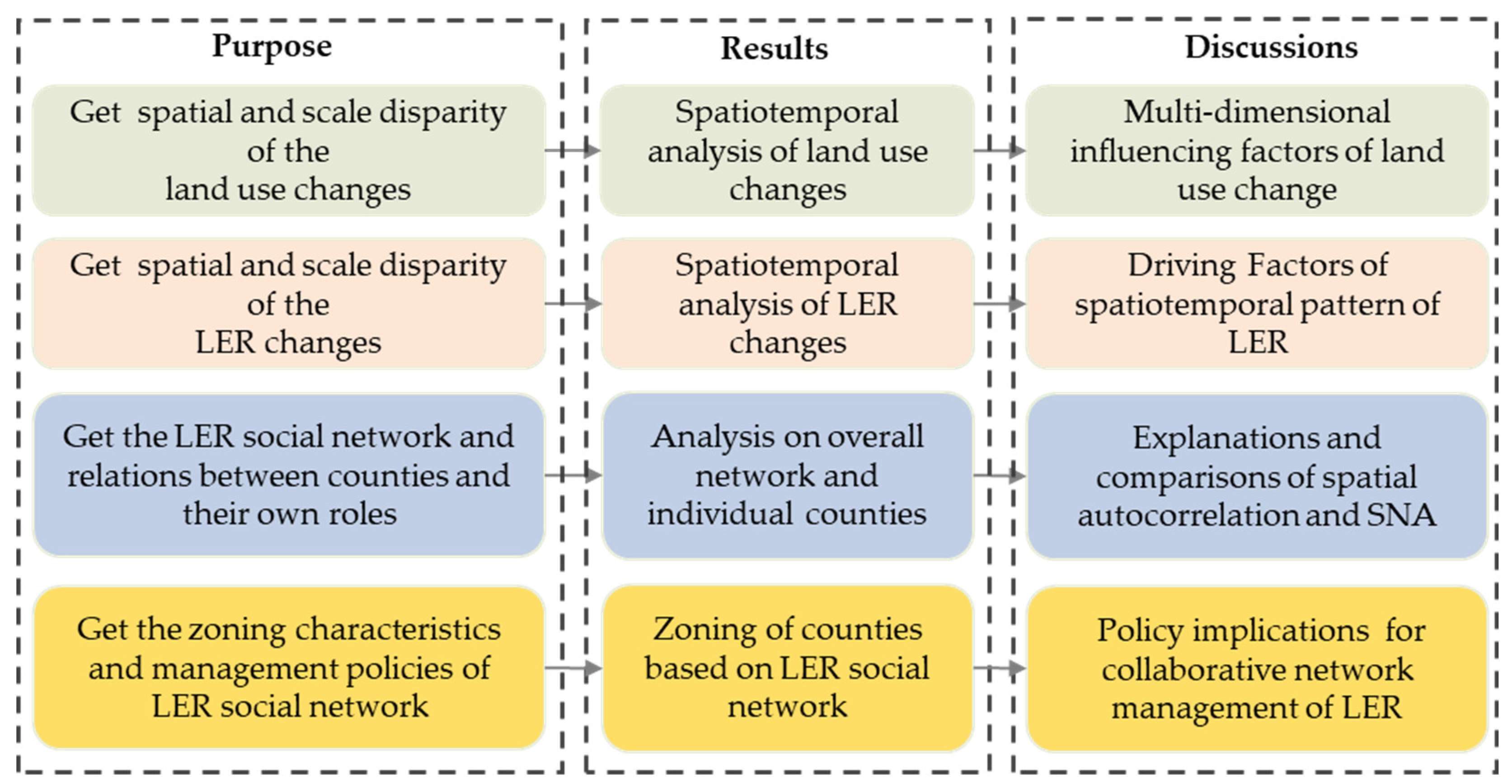
2.1. Analytical Framework
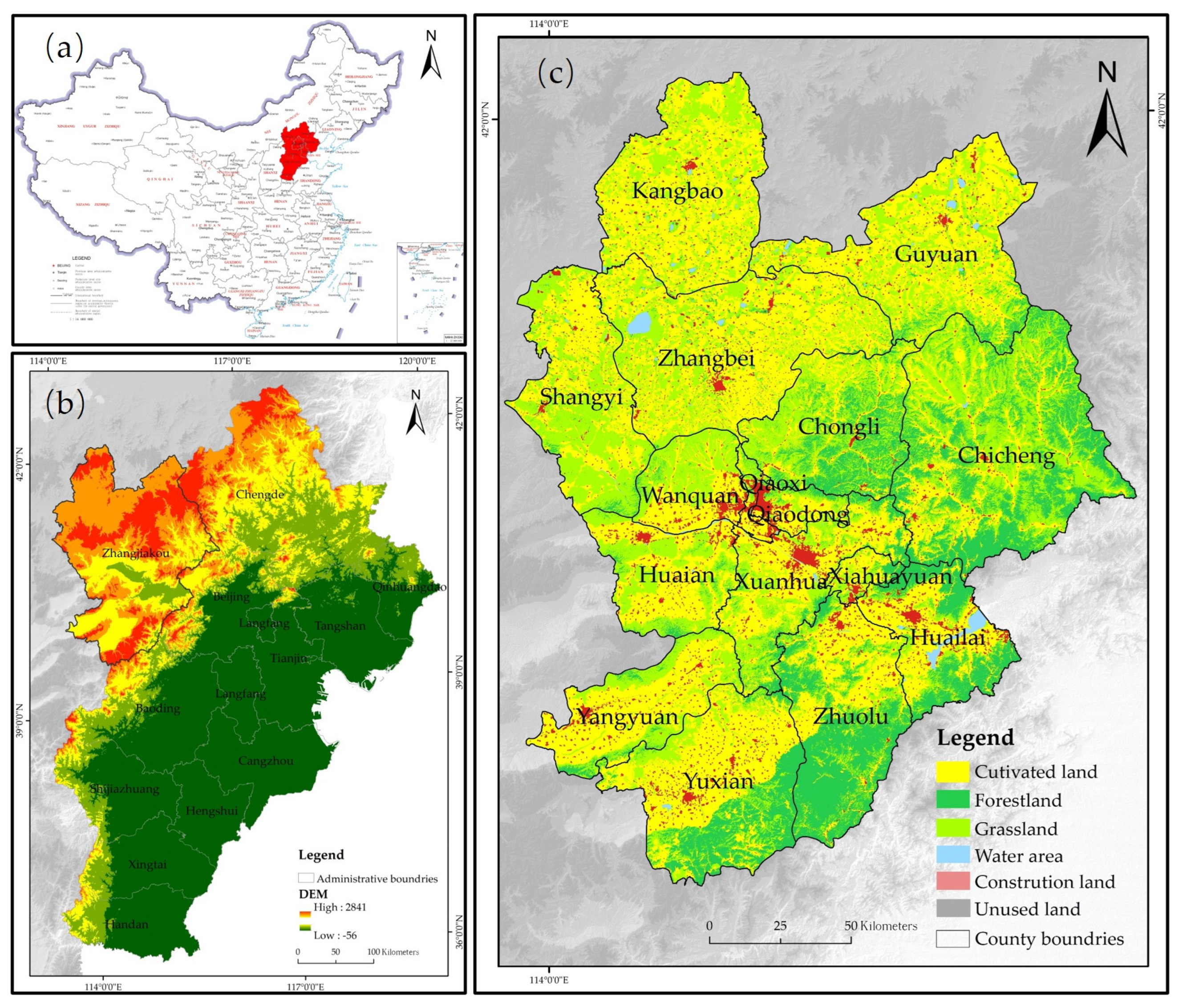
2.2. Overview of the Study Area
2.3. Data Source
2.4. Methods
2.4.1. Land Use Changes Analysis
- (1)
- Land Use Transfer Matrix
- (2)
- Geographical Distribution Measurement
2.4.2. Landscape Ecological Risk Assessment
2.4.3. Spatial Analysis Methods
- (1)
- Global Spatial Autocorrelation
- (2)
- Social Network Analysis (SNA) Method
3. Results
3.1. Spatiotemporal Analysis of Land Use Changes in Zhangjiakou
3.2. Spatiotemporal Analysis of Landscape Ecological Risk (LER) Changes in Zhangjiakou
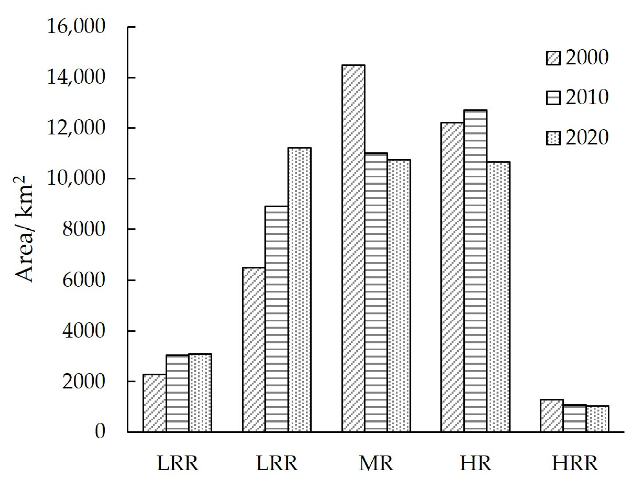
3.2.1. Overall Analysis on LER
3.2.2. Distribution of Land Use Types in LER
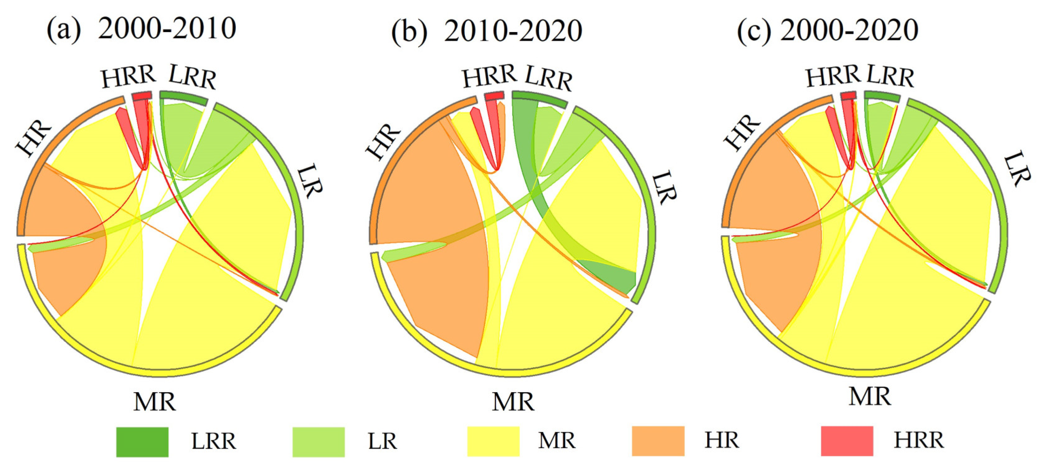
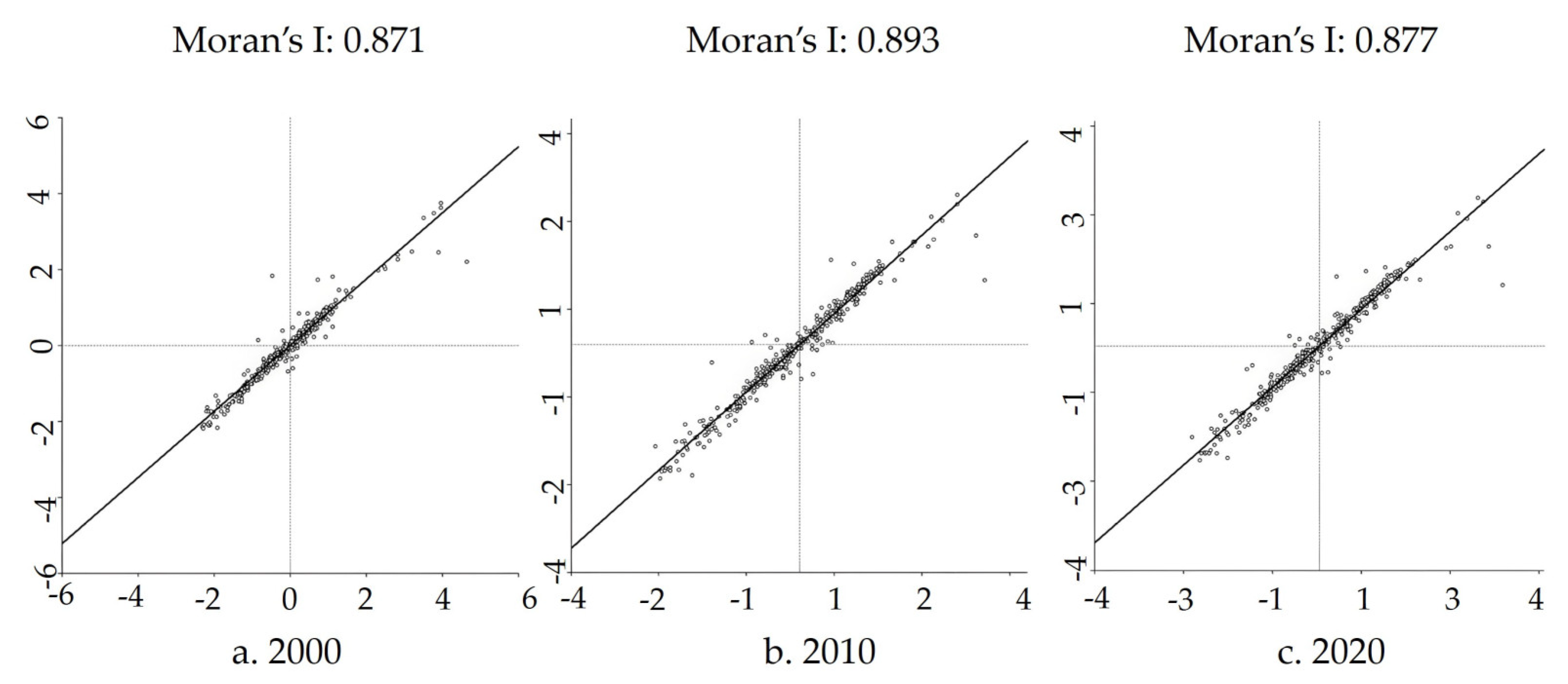
3.2.3. Spatial Analysis on LER
3.3. Social Network Analysis of LER
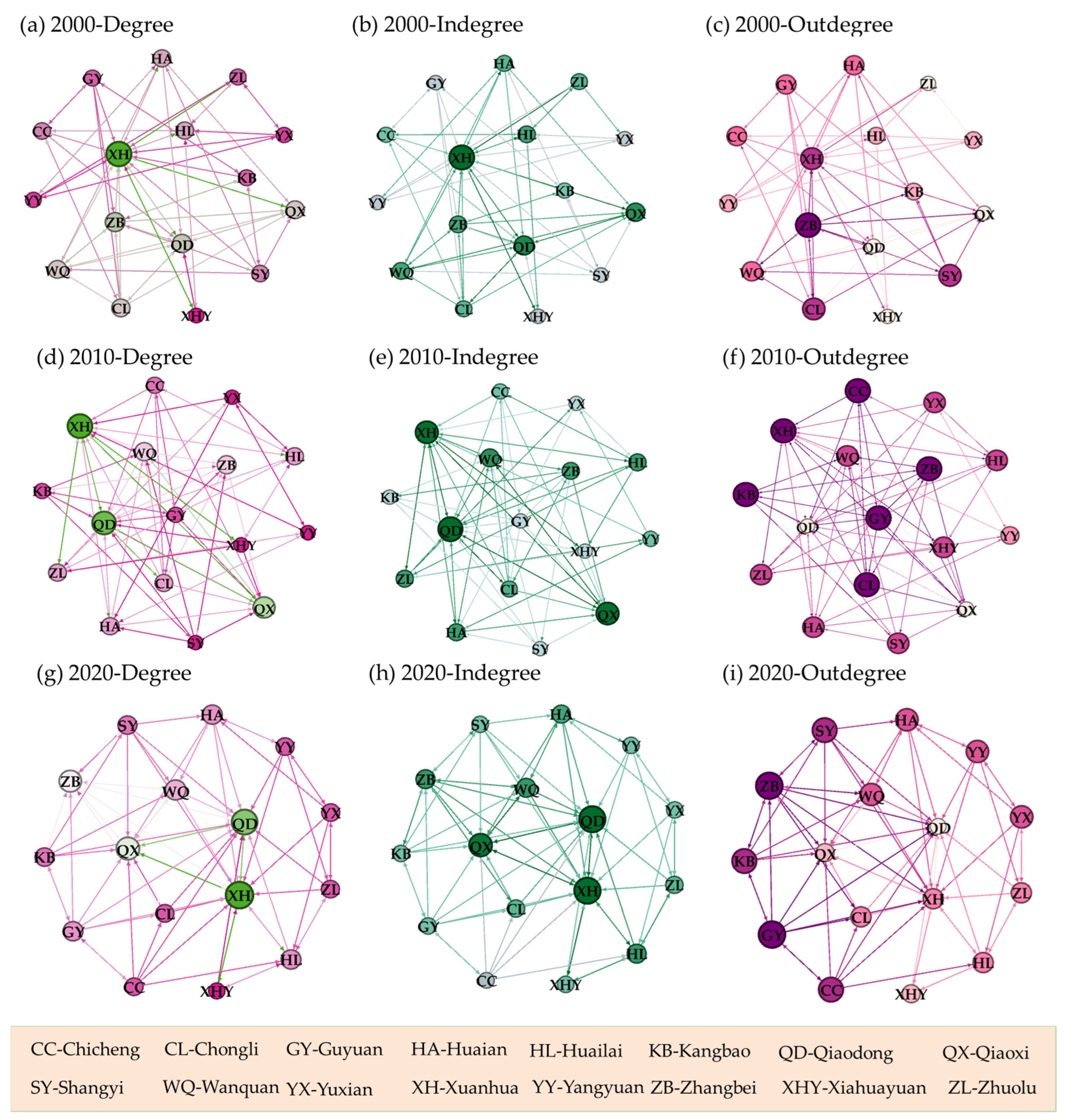
3.3.1. Analysis on Overall Network and Individual Counties
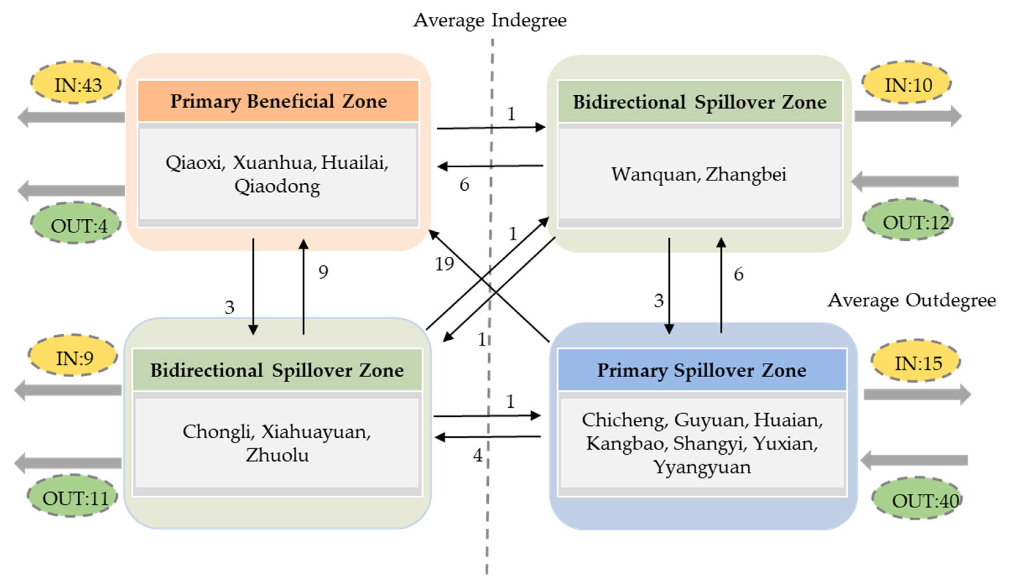
3.3.2. Zoning of Counties Based on LER Social Network
4. Discussion
4.1. Multi-Dimensional Influencing Factors of Land Use Change
4.2. Driving Factors of Spatiotemporal Pattern of LER
4.3. Explanations and Comparisons of Spatial Autocorrelation and Social Network Analysis
4.4. Policy Implications for Collaborative Network Management of LER
4.5. Research Limitations and Future Directions
5. Conclusions
- (1)
- From 2000 to 2020, the transfer among cultivated land, forestland, and grassland significantly dominated the land use change in Zhangjiakou. Construction land exhibited the most substantial expansion, which was primarily concentrated in the urban built-up areas and areas along the Jing-Zhang Railway.
- (2)
- During the study period, the LER in Zhangjiakou exhibited a decline trend. In spatial analysis, the overall distribution pattern of LER in Zhangjiakou demonstrated a relatively stable yet dynamic trend. The LER in the transitional areas between Bashang Plateau–Baxia Plain and the foothills exhibited relatively higher level. Throughout the study period, Zhangjiakou consistently exhibited a spatial clustering of the LER, which demonstrated an overall upward trend.
- (3)
- Xuanhua, Qiaodong, Qiaoxi, Wanquan, and Zhangbei hold a crucial position in the LER collaborative management network. Based on the SNR results, counties of Zhangjiakou were classified into three zones. Counties in primary spillover zone should prioritize measures to mitigate the local LER. While counties in the primary beneficial zone should consider implementing policies such as intercounty transfer payments, counterpart-assistance programs, and support for the provision of necessary professional assistance. Meanwhile, counties in the bidirectional correlation zone should act as intermediaries, actively promoting cooperation and consensus-building among counties.
Author Contributions
Funding
Data Availability Statement
Conflicts of Interest
References
- Cui, B.; Zhang, Y.; Wang, Z.; Gu, C.; Liu, L.; Wei, B.; Gong, D.; Rai, M.K. Ecological Risk Assessment of Transboundary Region Based on Land-Cover Change: A Case Study of Gandaki River Basin, Himalayas. Land 2022, 11, 638. [Google Scholar] [CrossRef]
- Qu, Z.; Zhao, Y.; Luo, M.; Han, L.; Yang, S.; Zhang, L. The Effect of the Human Footprint and Climate Change on Landscape Ecological Risks: A Case Study of the Loess Plateau, China. Land 2022, 11, 217. [Google Scholar] [CrossRef]
- Bing, Z.; Qiu, Y.; Huang, H.; Chen, T.; Zhong, W.; Jiang, H. Spatial distribution of cultural ecosystem services demand and supply in urban and suburban areas: A case study from Shanghai, China. Ecol. Indic. 2021, 127, 10772. [Google Scholar] [CrossRef]
- Zhang, W.; Chang, W.J.; Zhu, Z.; Hui, Z. Landscape ecological risk assessment of Chinese coastal cities based on land use change. Appl. Geogr. 2020, 117, 102174. [Google Scholar] [CrossRef]
- Sobhani, P.; Esmaeilzadeh, H.; Barghjelveh, S.; Sadeghi, S.M.M.; Marcu, M.V. Habitat Integrity in Protected Areas Threatened by LULC Changes and Fragmentation: A Case Study in Tehran Province, Iran. Land 2021, 11, 6. [Google Scholar] [CrossRef]
- Shen, W.; Zhang, J.; Wang, K.; Zhang, Z. Identifying the spatio-temporal dynamics of regional ecological risk based on Google Earth Engine: A case study from Loess Plateau, China. Sci. Total Environ. 2023, 873, 162346. [Google Scholar] [CrossRef] [PubMed]
- Carriger, J.F.; Parker, R.A. Conceptual Bayesian networks for contaminated site ecological risk assessment and remediation support. J. Environ. Manag. 2021, 278, 111478. [Google Scholar] [CrossRef] [PubMed]
- Ji, Z.; Liu, C.; Xu, Y.; Sun, M.; Wei, H.; Sun, D.; Li, Y.; Zhang, P.; Sun, Q. Quantitative identification and the evolution characteristics of production–living–ecological space in the mountainous area: From the perspective of multifunctional land. J. Geogr. Sci. 2023, 33, 779–800. [Google Scholar] [CrossRef]
- Wang, X.; Zhang, X.; Feng, X.; Liu, S.; Yin, L.; Chen, Y. Trade-offs and Synergies of Ecosystem Services in Karst Area of China Driven by Grain-for-Green Program. Chin. Geogra. Sci. 2020, 30, 101–114. [Google Scholar] [CrossRef]
- Sun, P.; Xu, Y.; Yu, Z.; Liu, Q.; Xie, B.; Liu, J. Scenario simulation and landscape pattern dynamic changes of land use in the poverty belt around Beijing and Tianjin: A case study of Zhangjiakou city, Hebei province. J. Geogr. Sci. 2016, 26, 272–296. [Google Scholar] [CrossRef]
- Liu, Y. Realizing China’s urban dream. Nature 2014, 509, 158–160. [Google Scholar]
- National Bureau of Statistics of China. China Statistical Yearbook; China Statistics Press: Beijing, China, 2022. [Google Scholar]
- Yuan, Y.; Chen, D.; Wu, S.; Mo, L.; Tong, G.; Yan, D. Urban sprawl decreases the value of ecosystem services and intensifies the supply scarcity of ecosystem services in China. Sci. Total Environ. 2019, 697, 134170. [Google Scholar] [CrossRef] [PubMed]
- Gomes, E.; Inácio, M.; Bogdzevič, K.; Kalinauskas, M.; Karnauskaitė, D.; Pereira, P. Future land-use changes and its impacts on terrestrial ecosystem services: A review. Sci. Total Environ. 2021, 781, 146716. [Google Scholar] [CrossRef] [PubMed]
- Guo, H.; Cai, Y.; Li, B.; Wan, H.; Yang, Z. An improved approach for evaluating landscape ecological risks and exploring its coupling coordination with ecosystem services. J. Environ. Manage. 2023, 348, 119277. [Google Scholar] [CrossRef] [PubMed]
- Peng, J.; Dang, W.; Liu, Y.; Zong, M.; Hu, X. Review on landscape ecological risk assessment. Acta Geogr. Sin. 2015, 70, 664–677. [Google Scholar]
- U.S. Environmental Protection Agency. Framework for Ecological Risk Assessment; EPA/630/R-92/001; Risk Assessment Forum, U.S. Environmental Protection Agency: Washington, DC, USA, 1992. [Google Scholar]
- U.S. Environmental Protection Agency. Guidelines for Ecological Risk Assessment; EPA/630/R-95/002F; Risk Assessment Forum, U.S. Environmental Protection Agency: Washington, DC, USA, 1998. [Google Scholar]
- Betrollo, P. Assessing landscape health: A case study from northeastern. Ital. Environ. Manag. 2001, 27, 349–365. [Google Scholar]
- Maanan, M.; Saddik, M.; Maanan, M.; Chaibi, M.; Assobhei, O.; Zourarah, B. Environmental and ecological risk assessment of heavy metals in sediments of Nador lagoon, Morocco. Ecol. Indic. 2015, 48, 616–626. [Google Scholar] [CrossRef]
- Bhuiyan, M.; Karmaker, S.; Bodrud-Doza, M.; Rakib, M.; Saha, B. Enrichment, sources and ecological risk mapping of heavy metals in agricultural soils of dhaka district employing SOM,PMF and GIS methods. Chemosphere 2021, 263, 128339. [Google Scholar] [CrossRef] [PubMed]
- Zeng, C.; He, J.; He, Q.; Mao, Y.; Yu, B. Assessment of Land Use Pattern and Landscape Ecological Risk in the Chengdu-Chongqing Economic Circle, Southwestern China. Land 2022, 11, 659. [Google Scholar] [CrossRef]
- Qian, Y.; Dong, Z.; Yan, Y.; Tang, L. Ecological risk assessment models for simulating impacts of land use and landscape pattern on ecosystem services. Sci. Total Environ. 2022, 833, 155218. [Google Scholar] [CrossRef] [PubMed]
- Li, S.; He, W.; Wang, L.; Zhang, Z.; Chen, X.; Lei, T.; Wang, S.; Wang, Z. Optimization of landscape pattern in China Luojiang Xiaoxi basin based on landscape ecological risk assessment. Ecol. Indic. 2023, 146, 109887. [Google Scholar] [CrossRef]
- Hunsaker, C.T.; Graham, R.L.; Suter, G.W.; O’Neil, R.V.; Barnthouse, L.W.; Gardner, R.H. Assessing ecological risk on a regional scale. Environ. Manag. 1990, 14, 325–332. [Google Scholar] [CrossRef]
- Graham, R.L.; Hunsaker, C.T.; O’Neil, R.V.; Jackson, B.L. Ecological risk assessment at the regional scale: Ecological archives A005-001. Ecol. Appl. 1991, 1, 196–206. [Google Scholar] [CrossRef] [PubMed]
- Sun, X.; Yang, P.; Tao, Y.; Bian, H. Improving ecosystem services supply provides insights for sustainable landscape planning: A case study in Beijing, China. Sci. Total Environ. 2022, 802, 149849. [Google Scholar] [CrossRef]
- Li, W.; Wang, Y.; Xie, S.; Sun, R.; Cheng, X. Impacts of landscape multifunctionality change on landscape ecological risk in a megacity, China: A case study of Beijing. Ecol. Ind. 2020, 117, 106681. [Google Scholar] [CrossRef]
- Bi, Y.; Zheng, L.; Wang, Y.; Li, J.; Yang, H.; Zhang, B. Coupling analysis of land use change with landscape ecological risk in China: A multi-scenario simulation perspective. Ecol. Indic. 2023, 146, 109871. [Google Scholar] [CrossRef]
- Xie, H.; Wen, J.; Chen, Q.; Wu, Q. Evaluating the landscape ecological risk based on GIS: A case-study in the poyang lake region of China. Land Degrad. Dev. 2021, 32, 2762–2774. [Google Scholar] [CrossRef]
- Du, L.; Dong, C.; Kang, X.; Qian, X.; Gu, L. Spatiotemporal evolution of land cover changes and landscape ecological risk assessment in the Yellow River Basin, 2015–2020. J. Environ. Manag. 2023, 332, 117149. [Google Scholar] [CrossRef]
- Gao, L.; Tao, F.; Liu, R.; Wang, Z.; Leng, H.; Zhou, T. Multi-scenario simulation and ecological risk analysis of land use based on the PLUS model: A case study of Nanjing. Sustain. Cities Soc. 2022, 85, 104055. [Google Scholar] [CrossRef]
- Li, Z.; Zhu, K.; Song, D.; Guan, D.; Cao, J.; Su, X.; Zhang, Y.; Zhang, Y.; Ba, Y.; Wang, H. Analysis of Spatial Relationship Based on Ecosystem Services and Ecological Risk Index in the Counties of Chongqing. Land 2023, 12, 1830. [Google Scholar] [CrossRef]
- Wang, L.; Wang, M. Chengdu-Chongqing Urban Landscape Ecological Risk Evolution Analysis. Resour. Environ. Yangtze Basin 2023, 32, 626–637. [Google Scholar]
- Wang, S.; Tan, X.; Fan, F. Landscape Ecological Risk Assessment and Impact Factor Analysis of the Qinghai–Tibetan Plateau. Remote Sens. 2022, 14, 4726. [Google Scholar] [CrossRef]
- Ai, J.; Yu, K.; Zeng, Z.; Yang, L.; Liu, Y.; Liu, J. Assessing the dynamic landscape ecological risk and its driving forces in an island city based on optimal spatial scales: Haitan Island, China. Ecol. Indic. 2022, 137, 108771. [Google Scholar] [CrossRef]
- Zhou, B.; Xu, J.; Yu, H.; Wang, L. Comprehensive assessment of ecological risks of Island destinations—A case of Mount Putuo Island, China. Ecol. Indic. 2023, 154, 110783. [Google Scholar] [CrossRef]
- Wolf, I.D.; Sobhani, P.; Esmaeilzadeh, H. Assessing Changes in Land Use/Land Cover and Ecological Risk to Conserve Protected Areas in Urban–Rural Contexts. Land 2023, 12, 231. [Google Scholar] [CrossRef]
- Wang, H.; Liu, X.; Zhao, C.; Chang, Y.; Liu, Y.; Zang, F. Spatial-temporal pattern analysis of landscape ecological risk assessment based on land use/land cover change in Baishuijiang National nature reserve in Gansu Province, China. Ecol. Indic. 2021, 124, 107454. [Google Scholar] [CrossRef]
- Zhang, X.; Yao, L.; Luo, J.; Liang, W. Exploring Changes in Land Use and Landscape Ecological Risk in Key Regions of the Belt and Road Initiative Countries. Land 2022, 11, 940. [Google Scholar] [CrossRef]
- Shi, Z.; Deng, W.; Zhang, S. Spatio-temporal pattern changes of land space in Hengduan Mountains during 1990–2015. J. Geogr. Sci. 2018, 28, 529–542. [Google Scholar] [CrossRef]
- Zhang, Y.; Hu, X.; Wei, B.; Zhang, X.; Tang, L.; Chen, C.; Wang, Y.; Yang, X. Spatiotemporal exploration of ecosystem service value, landscape ecological risk, and their interactive relationship in Hunan Province, Central-South China, over the past 30 years. Ecol. Indic. 2023, 156, 111066. [Google Scholar] [CrossRef]
- Ren, D.; Cao, A. Analysis of the heterogeneity of landscape risk evolution and driving factors based on a combined GeoDa and Geodetector model. Ecol. Indic. 2022, 144, 109568. [Google Scholar] [CrossRef]
- Yu, Z.; Chen, L.; Tong, H.; Chen, L.; Zhang, T.; Li, L.; Yuan, L.; Xiao, J.; Wu, R.; Bai, L.; et al. Spatial correlations of land-use carbon emissions in the Yangtze River Delta region: A perspective from social network analysis. Ecol. Indic. 2022, 142, 109147. [Google Scholar] [CrossRef]
- He, Y.; Wei, Z.; Liu, G.; Zhou, P. Spatial network analysis of carbon emissions from the electricity sector in China. J. Clean. Prod. 2020, 262, 121193. [Google Scholar] [CrossRef]
- Huo, T.; Cao, R.; Xia, N.; Hu, X.; Cai, W.; Liu, B. Spatial correlation network structure of China’s building carbon emissions and its driving factors: A social network analysis method. J. Environ. Manag. 2022, 320, 115808. [Google Scholar] [CrossRef] [PubMed]
- Qiao, Q.; Zhen, Z.; Liu, L.; Luo, P. The Construction of Ecological Security Pattern under Rapid Urbanization in the Loess Plateau: A Case Study of Taiyuan City. Remote Sens. 2023, 15, 1523. [Google Scholar] [CrossRef]
- Zhang, M.; Liu, X.; Peng, S.; Zhang, Y.; Chen, Y.; Wen, L. Evolution Characteristics and Formation Mechanism of Spatial Correlation Network of Provincial Land Use Carbon Emission Efficiency in China. China Land Sci. 2023, 37, 91–101. [Google Scholar]
- Jiang, Q.; Ma, X. Spillovers of environmental regulation on carbon emissions network. Technol. Forcast Soc. 2021, 169, 120825. [Google Scholar] [CrossRef]
- Shen, W.; Liang, H.; Dong, L.; Ren, J.; Wang, G. Synergistic CO2 reduction effects in Chinese urban agglomerations: Perspectives from social network analysis. Sci. Total Environ. 2021, 798, 149352. [Google Scholar] [CrossRef]
- Sun, L.; Qin, L.; Taghizadeh-Hesary, F.; Zhang, J.; Mohsin, M.; Chaudhry, I.S. Analyzing carbon emission transfer network structure among provinces in China: New evidence from social network analysis. Environ. Sci. Pollut. Res. Int. 2020, 27, 23281–23300. [Google Scholar] [CrossRef]
- Liu, H.; Liu, C.; Sun, Y. Spatial correlation network structure of energy consumption and its effects in China. China Ind. Econ. 2015, 5, 83–95. [Google Scholar]
- Li, J. Structural Characteristics and Evolution Trend of Collaborative Governance of Air Pollution in “2 + 26” Cities from the Perspective of Social Network Analysis. Sustainability 2023, 15, 5943. [Google Scholar] [CrossRef]
- Chong, Z.; Qin, C.; Ye, X. Environmental Regulation and Industrial Structure Change in China: Integrating Spatial and Social Network Analysis. Sustainability 2017, 9, 1465. [Google Scholar] [CrossRef]
- Ji, Z.; Xu, Y.; Sun, M.; Liu, C.; Lu, L.; Huang, A.; Duan, Y.; Liu, L. Spatiotemporal characteristics and dynamic mechanism of rural settlements based on typical transects: A case study of Zhangjiakou City, China. Habitat. Int. 2022, 123, 102545. [Google Scholar] [CrossRef]
- Huang, A.; Xu, Y.; Sun, P.; Zhou, G.; Liu, C.; Lu, L.; Xiang, Y.; Wang, H. Land use/land cover changes and its impact on ecosystem services in ecologically fragile zone: A case study of Zhangjiakou City, Hebei Province, China. Ecol. Indic. 2019, 104, 604–614. [Google Scholar] [CrossRef]
- Pan, T.; Zuo, L.; Zhang, Z.; Zhao, X.; Sun, F.; Zhu, Z.; Liu, Y. Impact of land usechange on water conservation: A case study of Zhangjiakou in Yongding River. Sustainability 2020, 13, 22. [Google Scholar] [CrossRef]
- Liu, C.; Xu, Y.; Lu, X.; Han, J. Trade-offs and driving forces of land use functions in ecologically fragile areas of northern Hebei Province: Spatiotemporal analysis. Land Use Policy 2021, 104, 105387. [Google Scholar] [CrossRef]
- Chen, J.; Cao, X.; Peng, S.; Ren, H. Analysis and Applications of GlobeLand30: A Review. Int. J. Geo-Inf. 2017, 6, 230. [Google Scholar] [CrossRef]
- Wang, Y.; Zhang, J.; Liu, D.; Yang, W.; Zhang, W. Accuracy Assessment of GlobeLand30 2010 Land Cover over China Based on Geographically and Categorically Stratified Validation Sample Data. Remote Sens. 2018, 10, 1213. [Google Scholar] [CrossRef]
- Chen, J.; Ban, Y.; Li, S. China: Open access to Earth land-cover map. Nature 2014, 514, 434. [Google Scholar]
- Zhu, K.; He, J.; Zhang, L.; Song, D.; Wu, L.; Liu, Y.; Zhang, S. Impact of Future Development Scenario Selection on Landscape Ecological Risk in the Chengdu-Chongqing Economic Zone. Land 2022, 11, 964. [Google Scholar] [CrossRef]
- ESRI ArcGIS Desktop. Available online: https://desktop.arcgis.com/zh-cn/arcmap/10.3/tools/spatial-statistics-toolbox.htm (accessed on 31 August 2023).
- Liu, Y.; Liao, H.; Li, T.; Cai, J.; Li, J.; He, T.; Luo, G. Spatio-temporal diversity and influencing factors of multi-functionality of land use in mountainous regions. Trans. Chin. Soc. Agr. Eng. 2019, 35, 271–279. [Google Scholar]
- Li, Y.; Liu, W.; Feng, Q.; Zhu, M.; Yang, L.; Zhang, J.; Yin, X. The role of land use change in affecting ecosystem services and the ecological security pattern of the Hexi Regions, Northwest China. Sci. Total Environ. 2023, 855, 158940. [Google Scholar] [CrossRef] [PubMed]
- Lin, L.; Wei, X.; Luo, P.; Wang, S.; Kong, D.; Yang, J. Ecological Security Patterns at Different Spatial Scales on the Loess Plateau. Remote Sens. 2023, 15, 1011. [Google Scholar] [CrossRef]
- Yan, J.; Li, G.; Qi, G.; Qiao, H.; Nie, Z.; Huang, C.; Kang, Y.; Sun, D.; Zhang, M.; Kang, X.; et al. Landscape ecological risk assessment of farming-pastoral ecotone in China based on terrain gradients. Hum. Ecol. Risk Assess. 2021, 27, 2124–2141. [Google Scholar] [CrossRef]
- Yuan, S.; Huang, J.; Zhu, C.; Mei, Z. Characteristics and Formation Mechanisms of Spatial Correlation Network of Production-Living-Ecological Functions in Metropolitan Areas: Taking Hangzhou Metropolitan Area as an Example. China Land Sci. 2024, 38, 56–67. [Google Scholar]
- Zhang, Y.; Dai, Y.; Ke, X. Spatial Correlation Network Characteristics of New-type Urbanization and Its lmpact on the Land Use Eco-efficiency in China: A Perspective of Network Centrality. China Land Sci. 2023, 37, 117–129. [Google Scholar]
- Gai, M.; Xu, J.; Yue, P. Characteristics and formation mechanism of spatial association network of coastal human-nature system resilience in the Bohai Rim region. Resour. Sci. 2024, 46, 565–582. [Google Scholar]
- Hai, X.; Zhan, X.; Wang, X. Study on the Characteristics of Carbon Emission Spatial Interconnection Networks at the Provincial Level in the Context of the ‘Double Carbon’ Target. Stat. Decis. 2024, 40, 85–89. [Google Scholar]
- Li, Z.; Guo, H.; Hu, Y.; Xu, L. Spatial correlation network structure and influencing factors of tourism ecological security in China. Acta Ecol. Sin. 2024, 44, 1–13. [Google Scholar]
- Lin, X.; Wang, Z. Landscape ecological risk assessment and its driving factors of multi-mountainous city. Ecol. Indic. 2023, 146, 109823. [Google Scholar] [CrossRef]
- Su, D.; Cao, Y.; Dong, X.; Wu, Q.; Fang, X.; Gao, Y. Evaluation of ecosystem services budget based on ecosystem services flow: A case study of Hangzhou Bay area. Appl. Geogr. 2024, 162, 103150. [Google Scholar] [CrossRef]


| Index | Symbol | Calculation | Ecological Meaning of Index |
|---|---|---|---|
| Landscape fragmentation | Ci | Ci reflects the degree to which a landscape is fragmented, indicating the complexity of its spatial structure and the extent of human disturbance to landscape. In the equation: ni is the number of patches of landscape type i and Ai is the total area of landscape type i. | |
| Landscape separation | Ni | Ni represents the degree of separation among individual patches within a specific landscape type. In the equation: ni denotes the number of patches of landscape type i, Ai represents the total area of landscape type I, and An indicates the total area of the region. | |
| Landscape fractal dimension | Di | Di represents the complexity of the shape of patches within a specific landscape type, reflecting the extent of human impacts on the landscape. In the equation: Pi denotes the perimeter of landscape type i and Ai represents the total area of landscape type i. | |
| Landscape disturbance | Ei | Ei reflects the degree of disturbance experienced by different landscape ecosystems. A smaller disturbance index is more favorable for biological survival. The weights for Ci, Ni, and Di are represented by the coefficients a, b, and c, respectively, with the condition that a + b + c = 1. Based on existing researches and thorough analysis, it is concluded that the fragmentation index holds primary significance, followed by separation degree and fractal dimension; the weights are determined as a = 0.5, b = 0.3, and c = 0.2. | |
| Landscape vulnerability | Vi | Normalizing processing | Vi reflects the sensitivity of different landscape types to external disturbances, with higher values indicating a weaker resistance to external interference. Drawing on previous research findings, the landscape vulnerability is assigned values as: unused land = 6, water area = 5, cultivated land = 4, grassland = 3, forestland = 2, construction land = 1. After the normalizing treatment, the Vi of each landscape type was obtained. |
| Landscape loss | Ri | Ri = Ei × Vi | Ri reflects the degree of loss of different landscape types when exposed to both natural and human disturbance. This is constructed using Ei and Vi. |
Disclaimer/Publisher’s Note: The statements, opinions and data contained in all publications are solely those of the individual author(s) and contributor(s) and not of MDPI and/or the editor(s). MDPI and/or the editor(s) disclaim responsibility for any injury to people or property resulting from any ideas, methods, instructions or products referred to in the content. |
© 2024 by the authors. Licensee MDPI, Basel, Switzerland. This article is an open access article distributed under the terms and conditions of the Creative Commons Attribution (CC BY) license (https://creativecommons.org/licenses/by/4.0/).
Share and Cite
Li, M.; Zhang, L.; Chen, Y.; Liu, S.; Cai, M.; Sun, Q. Construction of Landscape Ecological Risk Collaborative Management Network in Mountainous Cities—A Case Study of Zhangjiakou. Land 2024, 13, 1586. https://doi.org/10.3390/land13101586
Li M, Zhang L, Chen Y, Liu S, Cai M, Sun Q. Construction of Landscape Ecological Risk Collaborative Management Network in Mountainous Cities—A Case Study of Zhangjiakou. Land. 2024; 13(10):1586. https://doi.org/10.3390/land13101586
Chicago/Turabian StyleLi, Mu, Lingli Zhang, Yuanyuan Chen, Shuangliang Liu, Mingyao Cai, and Qiangqiang Sun. 2024. "Construction of Landscape Ecological Risk Collaborative Management Network in Mountainous Cities—A Case Study of Zhangjiakou" Land 13, no. 10: 1586. https://doi.org/10.3390/land13101586
APA StyleLi, M., Zhang, L., Chen, Y., Liu, S., Cai, M., & Sun, Q. (2024). Construction of Landscape Ecological Risk Collaborative Management Network in Mountainous Cities—A Case Study of Zhangjiakou. Land, 13(10), 1586. https://doi.org/10.3390/land13101586