Abstract
The karst of the horsts of the Bakony Region belonging to horst types of different development is described. Horsts elevated to the summit position are characterised by the most widespread and diverse karstification (with covered karst, cave-ins and shafts). Cryptopeneplains affect the karstification of horsts elevated to the summit position, but karst features also occur in their areas. On threshold surfaces of marginal position, the hypogene branches of regional flow systems influenced the development of spring caves. The karstification of basaltic mountains has been mainly governed by the properties of the basalt caprock (the major features being ponors with blind valleys and caprock dolines).
1. Introduction
In this study, the karst of the horsts of the Bakony Region belonging to horst types of different development is described. Horsts belonging to different types have different elevations, expansions and coveredness (the expansion and quality of the cover), degrees and methods of its exposure, environments and positions as compared to karstwater level, bedrock morphologies and the presence of the aquifuge that is intercalated into the bedrock. Therefore, the reason for the different karstification of horst types is found in one (or even several) of the above factors and thus, the karstification of the horsts is traced back to such properties. The karstifications of the horst types differ from each other to a larger and smaller degree, which can also be interpreted by the consideration of the above-mentioned factors.
Modern karst research focuses on the detailed study (hydrology, geomorphology) of different karst areas [1,2,3,4,5,6]. This will be followed in the case of the description of the karst of the Bakony Region. The flow systems of the karst of the Bakony Region are classified based on the work of Klimchouk [7] and Goldscheider et al. [8], its karst features and their characteristics are described considering the work of Sweeting [9], White [10], Waltham et al. [11], Ford and Williams [12], Gutierrez [13] and Veress [14].
Basic features of karsts are features that can be found nearly on all karst types, but in different densities. The karst features are the following: karren, dolines and uvalas (they may have different varieties on different karst types), ponors with blind valleys, poljes, concretions, karstic gorges, inselberg karst and subsurface karst features [11]. Their common characteristic feature is that they develop by dissolution (caves are partly formed by erosion) and, with the exception of gorges and some karren features, surface features are closed.
Karren may develop on bare surfaces (rillenkarren, rinnenkarren, grikes) or below the soil (kamenitza, grike, rootkarren). Some of them may develop on both bare surfaces and soil-covered surfaces, or on karst covered with sediment too. Among dolines, solution dolines (mainly drawdown dolines) are distinguished, which are widespread on soil-covered karst. Caprock dolines are formed on the caprock, on consolidated rock, while the several varieties of subsidence dolines develop on permeable, unconsolidated rock. Collapse dolines develop by collapse processes. Poljes are large features with independent hydrography (with springs, surface streams and ponors). Concretions are accumulation features that develop at karst springs and in the channels of streams. Ponors are formed along rock boundaries where the water of the streams from non-karstic areas flows into the karst. Inselberg karst is a complex landform assemblage and is constituted by residuals (inselbergs) of various shapes that developed by dissolution.
There are caves that develop by dissolution (spring caves, shafts), while others are of both dissolution and erosion origin (inflow cave, through cave, spring cave).
Among karst types, evaporate karsts and carbonate karsts are distinguished. Carbonate karsts include temperate karsts, tropical karsts, glaciokarsts, mixed allogenic-autogenic karsts and covered karsts. Their features are partly different. On temperate karsts, solution dolines are specific, while on mixed autogenic–allogenic karsts, there are ponors with blind valleys, on glaciokarsts, karren and shafts, on covered karsts, caprock dolines and subsidence dolines, on tropical karsts, inselberg karst, and on Mediterranean karst and tropical karsts, poljes are common.
A variety of temperate karsts have a horst structure, such as the Bakony Region. Since this karst is constituted by horsts of different structures and development, there occur features that are characteristic of covered karst, partly of soil-covered karst and of mixed allogenic–autogenic karst. However, it has to be noted that some features as epigenetic-antecedent gorges and cave-ins related to them are particularly specific to the Bakony Region.
2. Study Area
The description below is based on Veress’s work [15]. The parts of the Bakony Region and the names of the features that are mentioned in this study are described in Figure 1. The Bakony Region is the southwestern part of the Transdanubian Mountains. It is surrounded by the Little Hungarian Plain in the NW, by Lake Balaton in the SE and the micro-regions of the Balaton Basin (Balaton Riviera, Tapolca Basin), the Great Hungarian Plain (Mezőföld) and the Vértes Mountains in the NE (and Mór Graben with graben structure). Its elevation is 150–700 m and its area is 4300 km2. Its largest area is the Bakony Mountains (2200 km2). Parts of the Bakony Region are the Keszthely Mountains, Northern Bakony, Southern Bakony, Balaton Uplands and Bakonyalja (Figure 1).
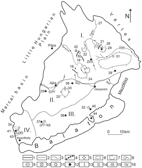
Figure 1.
Parts of the Bakony Region. Legend: 1. boundary of mountains, 2. boundary of micro-region group, 3. stream, 4. horst, 5. basaltic horst, 6. plateau, 7. basin, 8. karst spring, 9. karst lake, 10. doline group, 11. cave, 12. settlement, 13. Northern Bakony, 14. Southern Bakony, 15. Balaton Uplands, 16. Keszthely Mountains, 17. Kőris Mountain, 18. Som Mountain, 19. Mester-Hajag, 20. Kab Mountain, 21. Sűrű mountain group, 22. Porva basin, 23. Lókút basin, 24. Hárskút basin, 25. Tapolca basin, 26. Dudar basin, 27. Cuha valley, 28. Gerence valley, 29. Ördög valley, 30. Ördög-lik of Kőris Mountain, 31. Alba-Regia cave, 32. Lóczy cave, 33. Öreg-köves inflow cave, 34. Cserszegtomaj caves, 35. Devecser, 36. Szentbékálla, 37. Tapolca, 38. Márkó, 39. Hajmáskér, 40. Balatonfüred, 41. Hévíz, 42. Eleven-Förtés doline group, 43. Lake Hévíz and its spring cave, 44. Tihany Peninsula, 45. Tapolca cave system.
The mountains are of horst structure, where more elevated horsts are mountains, while less elevated horsts are basins. They are mainly built up of Triassic dolomite which is significantly widespread on the surface too [16]. However, Triassic, Dachstein and Jurassic limestones frequently occur in great extension on the horsts of higher elevation. Cretaceous and Eocene limestones of smaller thickness can mainly be found in larger and smaller areas on horsts with medium elevation, mostly covered with loess. Horsts of lower elevation (basins) are mostly covered by non-karstic rocks (Middle Oligocene–Lower Miocene gravels, Figure 2).
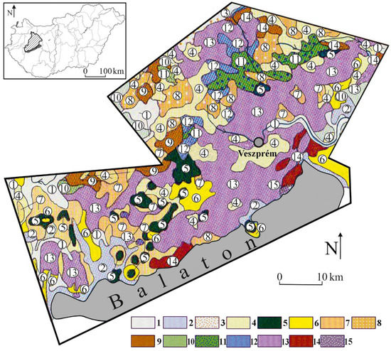
Figure 2.
Geological map of the Bakony Region [17]. Legend: 1. fluvial sediment, 2. Holocene peat, 3. Holocene wind-blown sand, 4. Pleistocene loess, 5. Pliocene basalt, 6. Upper-Miocene freshwater limestone, 7. Middle Miocene limestone, 8. Oligocene gravel, 9. Eocene limestone, 10. Upper Cretaceous limestone, 11. Lower Cretaceous limestone, 12. Jurassic limestone, 13. Triassic limestone, dolomite, 14. Permian sandstone, 15. old Paleozoic phyllite.
The uniformly developed karstwater reserves of the mountains (regional groundwater, Figure 3), mostly stored in the main dolomite and preceding karstwater; pumping it resurged not only in karst springs, but also fed karstic swamps and lakes (Lake Balaton) [18,19]. However, it is also transmitted into the basin sediments of the environs [20,21] (Figure 3).
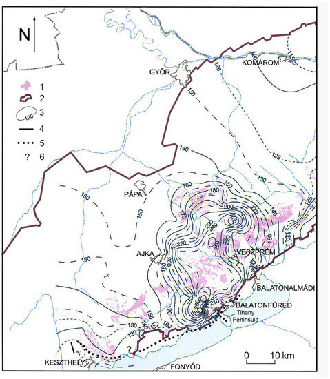
Figure 3.
Karstwater map of the Bakony Mountains [21]. Regional groundwater of the mountains according to the state of January 2006. Legend: 1. infiltration area, 2. boundary of groundwater storage, 3. altitude of the isoline of groundwater level, 4. hypogene branch, 5. former hypogene branch, 6. termination boundary is not known.
In the Bakony Region, where impermeable intercalations are mainly in the Middle-Eocene limestone (Szőc Limestone Formation) and in Cretaceous limestones, perched water tables developed in some horsts and horst groups [22,23]. Particularly, the percolating water of the gorges of the Bakony Mountains [22] may significantly feed the perched water tables, however, at sites where the aquifuge is absent or already removed by erosion, it feeds the regional groundwater [24].
As the horsts of the mountains performed oscillating movements since the Late Cretaceous period, Pécsi [25] put them into different genetic types (Figure 4). He distinguished cryptopeneplain (up to 300 m elevation, it is covered with non-karstic impermeable rocks, morphologically basin), low-threshold surface (up to 300 m, its surface is built up of Triassic carbonates), horst elevated to summit position (surface elevation is 400–550 m, constituting rocks are Cretaceous and Eocene limestones, on which mainly permeable loess accumulations are found, morphologically mountain), horst in summit position (surface elevation is 600–700 m, Triassic and Jurassic carbonates are widespread at its surface, cover only occurs in patches) and horst type with basalt cover (basalt caprock and widespread loess cover).
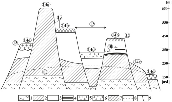
Figure 4.
Horst types of the mountains [26]. 1. non-karstic rock, 2. Triassic carbonates, 3. Jurassic, Cretaceous and Eocene limestones, 4. impermeable intercalation, clay, marly limestone, silica, etc., 5. basalt, 6. gravel, 7. loess, 8. karst water table, 9. fault, 10. karst water storey, 11. main karst water, 12. basin, graben, 13. mount, 14a. horst in summit position, 14b. horst elevated to summit position, 14c. threshold surface, 14d. cryptopeneplain, 14e. horst covered with basalt.
3. Factors Influencing Its Karstification
In the Bakony Region, two flow systems are present, a regional and a local. At the ascending branches of regional flows, hypogene karst systems are present, while at the descending branches of regional flows and at local flows, epigene karst systems are present. The main constituent of regional flow is the regional groundwater, which is not exclusively fed by descending waters, but also by the water of the perched water table, which percolates along fractures and faults. The regional flow with a NW–SE direction partly resurges in the karst springs of mountain margins, and, to a larger extent, it arrives at the sediment and at carbonate rocks on the floor of surrounding basins. In the SW, the former hypogene branch extended from the Keszthely Mountains nearly to the NE termination of Lake Balaton (Figure 3). Members of this branch are the Cserszegtomaj Caves [27,28] and the Lóczy Cave [29,30]. The hypogene branch still exists at Lake Hévíz, which is represented by the water of the spring cave of Lake Hévíz with a temperature of 40 °C [31].
Local flow occurs at sites where the limestones constituting the horsts are interbedded with impermeable or partly impermeable intercalations (marl, chert, clay). Such local flow is particularly characteristic of the Cretaceous limestone horsts of Northern Bakony (for example on Mester-Hajag Figure 5).
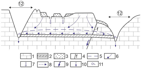
Figure 5.
Water flow system of Mester-Hajag: Legend: 1. limestone, 2. impermeable intercalation, 3. permeable cover, 4. fault, 5. karstwater level, 6. infiltration, 7. local water inflow, 8. water motion above aquifuge, 9. water drainage along fault, 10. linear seepage, 11. spring, 12. epigenetic valley.
As has already been mentioned, the mountains are separated into horsts of different elevations, expansions and evolutions [21]. The distribution of horst types in the mountains is described in Figure 6.
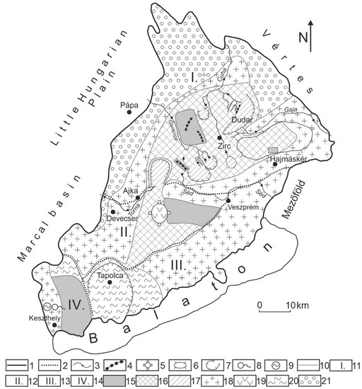
Figure 6.
Distribution of horst types in the Bakony Region. Legend: 1. boundary of the mountains, 2. boundary of micro-region group, 3. stream, 4. horst, 5. basaltic horst, 6. plateau, 7. basin, 8. karst spring, 9. karst lake, 10. boundary of horst type, 11. Northern Bakony, 12. Southern Bakony, 13. Balaton Uplands, 14. Keszthely Mountains, 15. horst in summit position, 16. horst elevated to summit position, 17. cryptopeneplain, 18. threshold surface, 19. horst with basalt cap, 20. buttes with basalt cap in karstic and non-karstic environments, 21. hilly country covered with superficial deposit (fluvial sediment, dune sand).
The majority of the mountains are covered by impermeable or permeable non-karstic sediment (mainly loess). The caprock thins out in some places (at the mounds of the bedrock or at creeks) as compared to its environment. On horsts covered with impermeable beds, epigenetic valleys of different stages of maturity emerged. These valleys may also have permanent streams at sites where a horst is surrounded by terrains covered with impermeable beds. As a result of the elevated position of the horst relative to its environment of covered terrain, some parts of these valleys are of epigenetic-antecedent origin and constitute gorges. On terrains covered with impermeable beds (for example on Kab Hill which is covered with basalt), mixed allogenic–autogenic karst developed.
The bedrock, therefore, became karstified and dissected into mounds and depressions. The mounds of Cretaceous limestones are partly exhumed. On the terrains between them, the caprock thinned out (Mester-Hajag). However, some parts of threshold surfaces that are uncovered and have a low elevation (below 300 m) are also dissected by mounds.
4. Materials and Methods
Based on geological maps, topographic maps and literary data, the areas of the mountains were classified as horst development types. Field studies and karstmorphological mappings were made in different areas of the mountains and types were determined with the help of their results, features and feature assemblages belonging to different karst types. Thus, there was an opportunity to describe the karst of certain horst types as well as to compare the different karstifications of horst types.
5. Discussion
The karst features are subsoil karren (these are grike and rootkarren on sandstone pseudokarren), subsidence dolines or sinkholes (mainly suffosion dolines), drawdown dolines, collapse dolines, caprock dolines, ponors with blind valleys, cave-ins, spring caves reflecting a thermal effect of various degrees, shafts, caves with wreathing, pseudokarst caves, freshwater limestones (in brook channels) and spring cones.
Among karst features, subsidence dolines are the most widespread. They occur in patches (altogether, in 22 patches, out of which, 19 patches are in the Northern Bakony) and in small numbers (there are about 700 subsidence dolines). Their size and density is small and a lot of them are inactive filled dolines. They occur at sites where the horst is covered with permeable sediment and where the caprock thinned out or was thin in the first place. These sites are the floors of creeks, terrains between exposed mounds, the covered mounds of the bedrock and limestone sites veneered with loess at which a larger quantity of water arrives from the surrounding impermeable rock or from the impermeable and wedging caprock [26] (Figure 7). On its soil-covered karst, some drawdown dolines and collapse dolines also occur (Tapolca Karst and the environs of Devecser). On the mixed allogenic–autogenic karst, ponors with blind valleys occur at the termination of the basalt cap (Figure 8). Caprock dolines also developed on the basalt by the collapse of the rock [32].
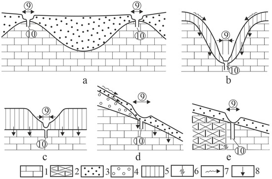
Figure 7.
Development of subsidence dolines [33]. Legend: Development of subsidence dolines at various development environments: (a) above the mound of the bedrock at low accumulation cover thickness, (b,c) at cover that thinned out in an erosional way, (d) at the termination of covered impermeable cover, (e) at the margin of covered, intercalated non-karstic rock, 1. limestone, 2. non-karstic rock, 3. permeable cover, 4. impermeable cover, 5. reworked, partly impermeable cover, 6. fault, 7. water flow, 8. infiltration, 9. subsidence doline, 10. shaft.
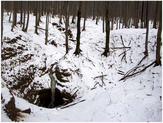
Figure 8.
Ponor of Macskalik cave (Kab Mountain).
Shaft caves are common and of relatively great dimension in the mountains (102 shaft caves) (Figure 9). Among them, there occur caves with significant length, for example, the Alba-Regia Cave which is on the Tés Plateau is 3.6 km long. Shafts open out of subsidence dolines and are of dissolution origin.
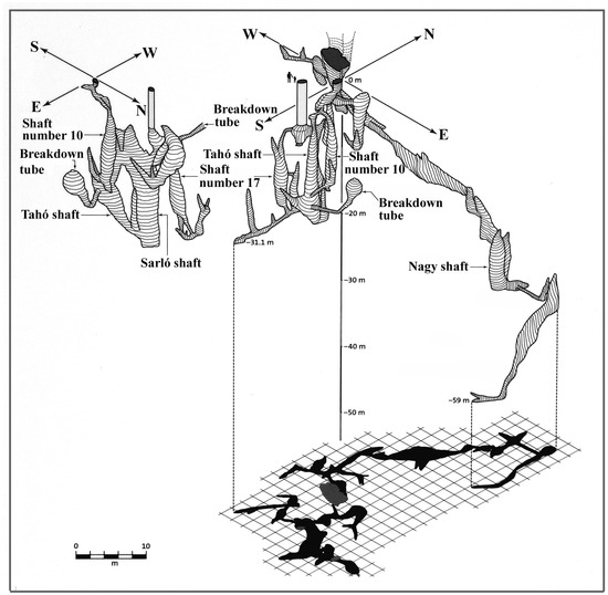
Figure 9.
Öregköves ponor shaft cave [34].
Among their caves, cave-ins are widespread (about 225 caves), which mostly occur in epigenetic-antecedent valley sides (about 212 caves); there are few spring caves (about 10 caves), and they were affected by thermal effects of various degrees. They are situated at the hypogene branch of the regional flow. The pseudokarren of the sandstone are also related to a former hypogene branch (Szentbékálla, Figure 10). Here, the silica that precipitated from warm water solution cemented Pannonian sand [35]. Amorphous silica that developed by precipitation is dissolved much more intensively than crystallised silica [9,36,37]. Karren (mainly kamenitzas) resulted from the dissolution of amorphous silica [32].
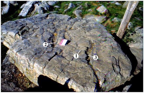
Figure 10.
Karren near Szentbékkálla. Legend: 1. sandstone polygon, 2. kamenitza, 3. rinnenkarren.
Pseudokarst caves are most widespread on basaltic terrains. From the ascending waters of the early hypogene branch, spring cones were built on the Tihany Peninsula (Figure 10) during the precipitation of dissolved limestone and from the diatom skeletons of lakes [38]. Materials of spring cones grew round and round space and thus, cavities developed (Figure 10).
The karst and karstification of the individual horst types are different, which can be traced back to the variations in geology, elevation, expansion, coveredness and hydrology of the horsts.
At the surface of horsts in the summit position (for example Kőris Mountain, Som Mountain), there are no local flows due to the distribution of Triassic Main Dolomite without impermeable intercalations, but descending branches of regional flows are present. Surface karstification is of low intensity; disregarding karren formation (on Dachstein limestones), it is only present at sites where sediment patches occur on the surface of such horsts.
The complete lack of surface karst features (drawdown dolines) can be traced back to the fact that in their area, the presence of low-inclined terrains is insignificant or they are completely absent. On steep terrains, no drawdown dolines develop. Based on literary data, according to Zámbó [39], at a surface with an inclination larger than 20°, no solution dolines occur. According to other data, doline development is the most intensive on surfaces with an inclination of 2–7° and there are no dolines on surfaces steeper than 13° in the Mecsek Mountains [40]. Telbisz et al. [41] state that in the Serbian Miroč Mountains, only 23% of surfaces with an inclination of 12° have dolines. All this can be traced back to the fact that on steep surfaces, the ratio of surface runoff increases and infiltration decreases. To our knowledge, there is only one subsidence doline group on this horst type (the Eleven-Förtés doline group on Kőris Mountain) where dolines developed on a terrain of low inclination, on a superficial deposit patch [42]. The infiltration and the survival of the superficial deposit was promoted by the fact that it is situated in a depression of the bedrock. Here, the Keszthely Mountains can also be mentioned, which are a lower elevated variety of these horst types (some mounds are at an altitude of 400–500 m), where 20 subsidence dolines occur [26]. There are also some inactive shafts on this horst type (for example, the Ördög-lik of Kőris Mountain). These were formed below subsidence dolines, but they became truncated after the denudation of the superficial deposit.
The epigenetic valleys of horsts deepened into the rock below the former regional groundwater level and exposed inactive, presently dry cavities (cave-ins, the medium section of Cuha Valley and the northern section of Gerence Valley).
In the mountains, the number and expansion of their horsts, which are horsts elevated to the summit position, is large. On these horsts, perched water tables overlie impermeable intercalations. Local flows developed at them, their descending branches are fed by the water of brooks percolating on valley floors, the water flowing into subsidence dolines that occur on the horst surface and by the infiltrating meteoric water. Waters of the outlet branch emerge in karst springs situated high above the regional groundwater level or they get into the regional groundwater along the fractures or faults that dissect the aquifuge (Figure 5). The subsidence dolines and cave-ins of the horst belong to the karst systems of local flows. Permeable superficial deposits are widespread on them and locally thin at several places for the already mentioned reasons.
The majority of subsidence dolines occur on horsts belonging to this type. As regards the horsts of Northern Bakony, subsidence dolines occur on 30% of horsts elevated to the summit position, while they can be found only on 9.1% of the horsts in the summit position and on 12.5% of cryptopeneplains [26]. These features developed at places where the cover is thin or thinned out (Figure 7). Since the shafts of the mountains occur below subsidence dolines, 90–95% of shafts can also be found on this horst type. Tés Plateau is a good example of the distribution of subsidence dolines and shafts, with 137 dolines and 46 shafts. However, the majority of cave-ins (estimated 80–90%) can also be found on the horsts of this type.
Cave-ins and cavities also occur subordinately in the sides of some epigenetic-regression valleys, but their majority and those longer than 1–2 m are exclusively in the walls of epigenetic-antecedent valley sections without exception. These valleys are formed on uplifting horsts which are surrounded by cryptopeneplain. The streams of the cryptopeneplain carve an antecedent valley section in the uplifting area of the horst. With their percolating water, streams generate a perched water table and trigger its cavity formation, then they deepen and open up the cavities at the top (inactive part) of the perched water table (cave-in). However, the perched water table can continue to accumulate if there is an aquifuge below the antecedent valley section. The Dudar Basin (cryptopeneplain) and the Sűrű hill group (horst elevated to summit position) constitute such a system where, for example, in the Ördög-árok there are more than 40 cave-ins of various sizes.
With their streams, cryptopeneplains have an important role in the hydrological and karstic development of the horsts in their environs. However, in the area of some cryptopeneplains (Hárskút Basin, Lókút Basin, Porva Basin), the material of the impermeable beds (Csatka Gravel Formation) has been partially eroded and the limestone outcrops became partially covered with loess. At these sites, for example, on the floor of epigenetic valleys, subsidence dolines, shafts and inactive shafts are common.
On the basaltic horst such as the Kab Hill, mixed allogenic–autogenic karst developed with ponors with blind valleys (Figure 8) and with inflow cave-like shafts (Figure 9). With the lack of erosion, they are of dissolution origin [32,43]. These features may have formed at the margin of the basalt cap or at the limestone outcrops within the basalt cap. On the basalt cover caprock, dolines are also common, which may develop into ponors with blind valleys [26], but on terrains with loess, subsidence dolines also occur.
On threshold surfaces, drawdown doline groups (Tapolca Karst, the environs of Devecser) are typical. The dolomite terrains of this horst type are dissected into mounds, but some dolines of small depth also occur on these surfaces (between Márkó and Hajmáskér). Some spring caves can also be mentioned from this horst type. These are connected to a former (Lóczy Cave) or present (the spring cave of Lake Hévíz) hypogene branch, but cavities opened up due to anthropogenic activity can also be found (Cserszegtomaj Caves). In case of the latter case, as well as the spring cave of Hévíz and the Lóczy Cave in Balatonfüred, a hot water effect is dominant, but in the development of the Tapolca cave system, lukewarm waters and cold waters also played a role. The landscape of threshold surfaces also includes the spring cones (Tihany Peninsula, Figure 10) and pseudokarren (Szentbékkálla, Figure 11).

Figure 11.
(A) spring cone, (B) exposed cavity (Tihany Peninsula).
In Hungarian karst literature, both the Transdanubian Mountains with the Bakony Region (which it is a part of) together are regarded as an independent karst type [44,45]. The Transdanubian Mountains are called Transdanubian type, while the other karst areas are called Aggtelek type. A more appropriate term is character instead of type. (Characteristics of karsts of Aggtelek character coincide with those of temperate soil-covered karst.) The difference may be traced back to the fact that the Transdanubian Mountains are poor in karst features, but hypogene caves are characteristic [46] and erosion caves and solution dolines are subordinate (they are absent). In contrast to the karsts of Transdanubian character, erosion caves, rootkarren and solution dolines are typical of the karsts of Aggtelek character [44]. However, morphological characteristics have become more accurate as compared to an earlier classification (for example rootkarren can also be found in the Transdanubian Mountains); basically, this differentiation is substantial.
The karst features of the Bakony Region are not widespread uniformly, but in patches of variable size. Although it is the most intensively karstified part of the Transdanubian Mountains, the frequency and size of their karst features is limited. The above characteristic feature can be traced back to its separation into horsts and to recent uplift. As a result of the former, karstification sites are localised (and thus, for example no ponors with significant catchment area developed), while, as a result of the latter karstification being young, there was little time for the development of karst features.
Karstic patches are constituted by subsidence dolines because this doline type is related to permeable superficial deposit patches, and the water infiltrated into the caprock ensures abundant (the water does not flow down low-inclined surfaces), permanent and uniform water supply to the epikarst (the already mentioned low resistances are evidence for this). This favours cavity formation and thus, shaft development in the epikarst. Abundant infiltration ensures favourable conditions for the transportation of superficial deposits into the karst. At sites where impermeable beds occur, neither subsidence dolines, nor other karst features occur. However, the small size of the horsts also results in a patchy appearance. On the other hand, the occurrence of solution dolines, a dominant variety of temperate soil-covered karst, is subordinate. All this results from the fact that, as has already been mentioned, the extension of low-inclined terrains is restricted in its uncovered terrain. In spite of the position of threshold surfaces at low elevation, this doline type occurs on them since their surface is low-inclined and hardly dissected.
Impermeable caprock is widespread in the mountain region. If it is the material of the Csatka Gravel Formation, a stream network develops on it because it is of clayey composition (cryptopeneplain). Their stream and valleys stretch across the surrounding horsts as epigenetic-regression valleys, on the floor of which, significant percolation may take place. However, percolation sites are not ponors. It may occur that the gravel cover already terminates in the area of the horst and its flowing water arrives at the margin of the cover. However, since the cover is of small extension, not even valleys develop on its surface. Waters arriving at the termination of the gravel cover form subsidence dolines on the loess surface that interacts with the cover. Ponors with blind valleys only developed at the termination of the basalt cover of the Kab Hill. Therefore, ponors with blind valleys are subordinate and inflow caves that constitute the continuation of such features are absent in the mountains. Concretions are subordinate either in the caves or on the surface, while they are missing from the poljes.
As mentioned above, the most widespread cave type in the mountain region is the cave-in. These are widespread in the sides of epigenetic-antecedent gorges. Their evolution contributed to the erosion of the impermeable beds (along which phreatic cavity formation took place) and of the stream since the area of the surrounding cryptopeneplain ensured abundant water supply to this.
Shafts are also characteristic; their frequency is comparable to that on other temperate karsts. The reason for this is the relatively high number of subsidence dolines. Subsidence doline development and shaft development interact. Shafts enable the local transportation of superficial deposits into the karst and thus, the development of indentations, while the developing subsidence dolines collect surface waters and transmit them into the epikarst. This favours the transformation of epikarst cavities into shafts.
There are no erosional inflow caves in the mountain region. The development of such caves can only be expected on Kab Hill, but the low inclination of the basaltic terrain and the lack of gravel do not favour erosion. Spring caves are also absent except for some which were transformed by a warm water effect. The reason for this is that there are only some karst springs in the mountains since their karst water, as mentioned above, flows in the surrounding basins [20], and the water emerged gallery-like and not point-like before karstwater extractions [18]
The stability of the surface karst of the mountains is also promoted by the fact that there has been a land use change and return to forestry and grazing in the past decades. These cultivation methods decrease the transport of superficial deposits into karst features. Thus, these features become filled to a lesser degree, or, if they do become filled, it takes place by natural processes.
Intensive mining activity took place in the mountains which could only be practiced safely by artificially sinking the karstwater level. In the past decades, the karstwater level has been rising and gradually reaching its former elevation. Thus, the operation of springs and spas (including medicinal waters), which are fed by the karstwater of the mountains, is ensured in the long term.
6. Conclusions
The karst of the mountains can primarily be related to various local flows, at which epikarst systems developed.
The karstification of horst types and thus their karst features are different. The karstification of horsts in the summit position is not significant since the water leaves the area of these horsts, and there is no permeable cover, or it hardly ever occurs in their area. The karstification of horsts elevated to the summit position is diverse where subsidence dolines are predominant because the permeable cover is widespread. The development of cave-ins was enabled by the impermeable intercalations of the horst and intensive valley deepening.
Cryptopeneplains only karstify at sites where their impermeable cover was denuded. Streams starting from these terrains cause gorge development on horsts elevated to the summit position and their cavity formation. Low-inclined surfaces of mountain marginal threshold surfaces favoured the development of some solution dolines and spring caves. Features reflecting a hot water effect (spring caves, sandstone karren, spring cones) also occur on this horst type. On the basaltic Kab Hill, ponor with blind valleys also developed.
Predominant karst features of the mountains are subsidence dolines, cave-ins and shafts. One of the important directions of future research may be the study of the epikarst, which helps obtain a better understanding of the development or lack of some karst features on different horst types.
Funding
This research received no external funding.
Data Availability Statement
No new data were created or analyzed in this study. Data sharing is not applicable to this article.
Conflicts of Interest
The author declare no conflict of interest.
References
- Denizman, C. Caves, sinkholes, and fractures in the eogenetic karst of Florida, a GIS-based spatial analysis. Acta Carsologica 2022, 51, 33–46. [Google Scholar] [CrossRef]
- Fernandes Ferreira, C.; Hussain, Y.; Uagoda, R. A semi-automatic approach for doline mapping in Brazilian covered karst: The way forward to vulnerability assessment. Acta Carsologica 2022, 51, 19–31. [Google Scholar] [CrossRef]
- Jones, B. Karst on the Cayman Islands. In Geology of the Cayman Islands; Springer: Cham, Switzerland, 2022. [Google Scholar] [CrossRef]
- Durán-Valsero, J.J.; Pardo-Igúzquiza, E.; Morales-García, R.; Luque-Espinar, J.A.; Durán-Laforet, S.R.; Balard, D.; Quiroga, E.; Borrás, J.; Ferreres, J. The Importance of Snow in the Hydrogeology of a High Relief Karst System: Sierra De Tendeñera, in the Pyrenees Mountain Range (Huesca, Northern Spain). In EuroKarst 2022, Málaga; Advances in Karst Science; Andreo, B., Barberá, J.A., Durán-Valsero, J.J., Gil-Márquez, J.M., Mudarra, M., Eds.; Springer: Cham, Swizterland, 2023. [Google Scholar] [CrossRef]
- Pardo-Igúzquiza, E.; Gil-Márquez, J.M.; Mudarra, M.; Andreo, B.; Durán-Valsero, J.J. Morphometric Comparison of Dolines in Three Karst Landscapes Developed on Different Lithologies. In EuroKarst 2022, Málaga; Advances in Karst, Science; Andreo, B., Barberá, J.A., Durán-Valsero, J.J., Gil-Márquez, J.M., Mudarra, M., Eds.; Springer: Cham, Switzerland, 2023. [Google Scholar] [CrossRef]
- Romano, G.; De Girolamo, M.; Parise, M. Geophysical Researches to Detect Karst Caves in the Main Polje of Apulia. In EuroKarst 2022, Málaga; Advances in Karst Science; Andreo, B., Barberá, J.A., Durán-Valsero, J.J., Gil-Márquez, J.M., Mudarra, M., Eds.; Springer: Cham, Switzerland, 2023. [Google Scholar] [CrossRef]
- Sweeting, M.M. Karst Landforms; Columbia University Press: New York, NY, USA, 1973; 362p. [Google Scholar]
- White, W.B. Geomorphology and Hydrology of Karst Terrains; Oxford University Press: New York, NY, USA; Oxford, UK, 1988; 463p. [Google Scholar]
- Waltham, T.; Bell, F.; Culshaw, M. Sinkholes and Subsidence; Springer: Berlin/Heidelberg, Germany, 2005; 382p. [Google Scholar]
- Klimchouk, A.B. Hypogene Speleogenesis: Hydrogeological and Morphogenetic Parspective; Special Paper No 1; National Cave and Karst Research Institute: Carlsbad, NM, USA, 2007; 106p. [Google Scholar]
- Ford, D.C.; Williams, P.W. Karst Hydrogeology and Geomorphology; John Wiley & Sons: Chichester, UK, 2007; 561p. [Google Scholar]
- Goldscheider, N.; Mádl-Szőnyi, J.; Erőss, A.; Schill, E. Review: Thermal water resources in carbonate rock aquifers. Hidrogeol. J. 2010, 18, 1303–1318. [Google Scholar] [CrossRef]
- Gutierrez, F.; Parise, M.; De Waele, J.; Jourde, H. A review on natural and human-induced geohazards and impacts in karst. Earth Sci. Rev. 2014, 138, 61–88. [Google Scholar] [CrossRef]
- Veress, M. Covered Karst; Springer: Dordrecht, The Netherlands, 2016; 536p. [Google Scholar] [CrossRef]
- Veress, M. The Effect of Mining Activities on the Paleokarstic Features, Recent Karstic Features, and Karst Water of the Bakony Region (Hungary). Mining 2022, 2, 757–768. [Google Scholar] [CrossRef]
- Kercsmár, Z.; Selmeczi, I.; Budai, T.; Less, G.; Konrád, G. Geology of the karst terrain sin Hungary. In Cave and Karst Systems of Hungary; Veress, M., Leél-Őssy, S., Eds.; Springer: Berlin/Heidelberg, Germany, 2022. [Google Scholar]
- Haas, J. Földtan (Geology). In Magyarország Térképekben; Kocsis, K., Schweitzer, F., Eds.; MTA, Földrajztudományi Kutatóintézet: Budapest, Hungary, 2011; pp. 35–38. (In Hungarian) [Google Scholar]
- Szádeczky-Kardos, E. A Dunántúli középhegység karsztvízének néhány problémájáról (On some problems of the karst water of the Transdanubian Mountains). Hidrológiai Közlöny 1941, 21, 67–92. (In Hungarian) [Google Scholar]
- Papp, F. Dunántúl karsztvizei és a feltárás lehetősége Budapesten (The karstwaters of Transdanubia and the opportunity of exploration in Budapest). Hidrológiai Közlöny 1942, 21, 146–196. (In Hungarian) [Google Scholar]
- Mádl-Szőnyi, J.; Erőss, A.; Csondor, K.; Iván, V.; Tóth, Á. Hydrogeology of the Karst regions in Hungary. In Cave and Karst Systems of Hungary; Veress, M., Leél-Őssy, S., Eds.; Springer: Cham, Switzerland, 2022; pp. 137–160. [Google Scholar]
- Csepregi, A. A karsztvíz kiemelés hatása a Dunántúli-Középhegység vízháztartására. (The effect of karst water extraction on the water balance of the Transdanubian Mountains) In Bányászati Karsztvízszint Süllyesztés a Dunántúli-Középhegységben; Alföldi, L., Kapolyi, L., Eds.; MTA Földrajztudományi Kutatóintézet: Budapest, Hungary, 2007; pp. 77–112. (In Hungarian) [Google Scholar]
- Jaskó, J. A balatonfelvidéki és északbakonyi patakok vízhozamának kapcsolata a földtani felépítéssel (The relation of discharge of the streams of Balaton Highlands and Northern Bakony with geological structure). Hidrológiai Közlöny 1961, 41, 75–84. (In Hungarian) [Google Scholar]
- Veress, M. Covered Karst Evolution Northern Bakony Mountains, W-Hungary; A Bakony Természettud. Kut. Eredményei 23; Bakonyi Természettudományi Múzeum: Zirc, Hungary, 2000; 167p. [Google Scholar]
- Bratán, M.; Mohos, P.; Zsuffa, I. A Gerence-patak hidrológiai tanulmánya (The hydrological study of Gerence stream). Hidrológiai Közlöny 1967, 47, 284–296. (In Hungarian) [Google Scholar]
- Bulla, B. Magyarország Természeti Földrajza; Physical Geography of Hungary; Tankönyvkiadó: Budapest, Hungary, 1964; 424p. (In Hungarian) [Google Scholar]
- Pécsi, M. A Pannóniai-medence morfogenetikája. (The Morphogenesis of the Pannonian basin). Földrajzi Értesítő 1980, 29, 105–127. (In Hungarian) [Google Scholar]
- Veress, M. The surface morphology of karsts in Hungary. In Cave and Karst Systems of Hungary; Veress, M., Leél-Őssy, S., Eds.; Springer: Cham, Switzerland, 2022; pp. 179–248. [Google Scholar]
- Leél-Őssy, S. Karszt és barlangkutatás a Szalonnai-karszton. (Karst and cave research on Szalonna karst). Hidrológiai Közlöny 1953, 33, 67–70. (In Hungarian) [Google Scholar]
- Kárpát, J. A Cserszegtomaji-kútbarlang (The well cave of Cserszegtomaj). Karszt és Barlang 1982, 1, 35–40. (In Hungarian) [Google Scholar]
- Leél-Őssy, S. Karsztmorfológiai vizsgálatok a balatonfüredi Lóczy-barlangban és környékén (Karstmorphological investigations in the Lóczy cave in Balatonfüred and in its environs). Földrajzi Értesítő 1958, 7, 379–381. (In Hungarian) [Google Scholar]
- Láng, S. A Bakony geomorfológiai képe (The geomorphology of the Bakony Mountains). Földrajzi Közlemények (In Hungarian). 1958, 82, 324–346. [Google Scholar]
- Plózer, I. A Hévízi-tó forrásbarlangjának feltárása (Exploration of the spring caves of Lake Hévíz). Karszt és Barlang 1977, 1–2, 65–66. (In Hungarian) [Google Scholar]
- Veress, M.; Unger, Z. Kab Mountain: Karst Under a Basalt Cap. In Landscapes and Landforms of Hungary; Lóczy, D., Ed.; Springer: Cham, Switzerland, 2015; pp. 55–62. [Google Scholar] [CrossRef]
- Veress, M. Development Environments and Factors of Subsidence Dolines. Geosciences 2021, 11, 513. [Google Scholar] [CrossRef]
- Győrffy, D. Geomorfológiai tanulmányok a Káli-medencében. (Geomorphological studies in the Káli basin). Földrajzi Értesítő 1957, 6, 265–299. (In Hungarian) [Google Scholar]
- Siffert, B. Quelques Reactions de la Silice en Solution: La Formation des Argiles; Memories du Service de la Carte: Paris, France, 1962. [Google Scholar]
- Siever, R. Silica solubility 0–200 °C and diagenesis of siliceous sediments. J. Geol. 1969, 70, 35–46. [Google Scholar] [CrossRef]
- Kovács-Pálffy, P.; Kalmár, J.; Veress, M. A Tihanyi-félsziget algás eredetű forrásüledékeinek ásvány-kőzettani vizsgálata. (Mineralogical-petrographic analyses of spring deposits of algal origin on the Tihany Peninsula). Karsztfejlődés 2007, 7, 111–135. (In Hungarian) [Google Scholar]
- Zámbó, L. Az Aggteleki-karszt felszínalaktani jellemzése. (Geomorphological description of Aggtelek Karst). Földrajzi Értesítő 1998, 47, 359–378. (In Hungarian) [Google Scholar]
- Lippmann, L.; Kiss, K.; Móga, J. Az Abaliget-Orfűi karszt karsztos felszínformáinak vizsgálata térinformatikai módszerekkel (Investigation of the karstic phenomenon near Orfű and Abaliget by GIS methods). Karsztfejlődés 2008, 13, 151–166. (In Hungarian) [Google Scholar]
- Telbisz, T.; Mari, L.; Kohán, B.; Čalić, J. A szerbiai Miroč-hegység töbreinek térinformatikai GPS-es terepi vizsgálata (A spatial informatics GPS study of the dolines of the Serbian Miroč Mountains). Karsztfejlődés 2007, 12, 71–90. (In Hungarian) [Google Scholar]
- Veress, M.; Puskás, J. Adalékok az Eleven-Förtési töbörcsoport (Bakony-hegység) karsztosodásához (Contributions to the karstification of the eleven-Förtés doline group, Bakony Mountains). Karsztfejlődés 2007, 12, 171–193. (In Hungarian) [Google Scholar]
- Móga, J.; Németh, R. The morphological research of the basalt and loess covered plateaus in the Bakony Mts. (Transdanubian middle mts.-Hungary). Acta Carsologica 2005, 34, 397–414. [Google Scholar]
- Jakucs, L. A magyarországi karsztok fejlődéstörténeti típusai (Evolutionary types of Hungarian karsts). Karszt és Barlang 1977, 1–2, 1–16. (In Hungarian) [Google Scholar]
- Hevesi, A. Magyarország karsztvidékeinek kialakulása és formakincse, I. rész (Development and landforms of karst regions in Hungary I). Földrajzi Közlemények 1991, 15, 25–35. (In Hungarian) [Google Scholar]
- Leél-Őssy, S.; Virág, M. The Caves of the Northeastern Part of the Transdanubian Mountains. In Cave and Karst Systems of Hungary; Cave and Karst Systems of the World; Veress, M., Leél-Őssy, S., Eds.; Springer: Cham, Switzerland, 2022. [Google Scholar] [CrossRef]
Disclaimer/Publisher’s Note: The statements, opinions and data contained in all publications are solely those of the individual author(s) and contributor(s) and not of MDPI and/or the editor(s). MDPI and/or the editor(s) disclaim responsibility for any injury to people or property resulting from any ideas, methods, instructions or products referred to in the content. |
© 2023 by the author. Licensee MDPI, Basel, Switzerland. This article is an open access article distributed under the terms and conditions of the Creative Commons Attribution (CC BY) license (https://creativecommons.org/licenses/by/4.0/).