
Asynchronous Transformation of Cropping Patterns from 5800–2200 cal BP on the Southern Loess Plateau, China

 , ,
, ,
Abstract
1. Introduction
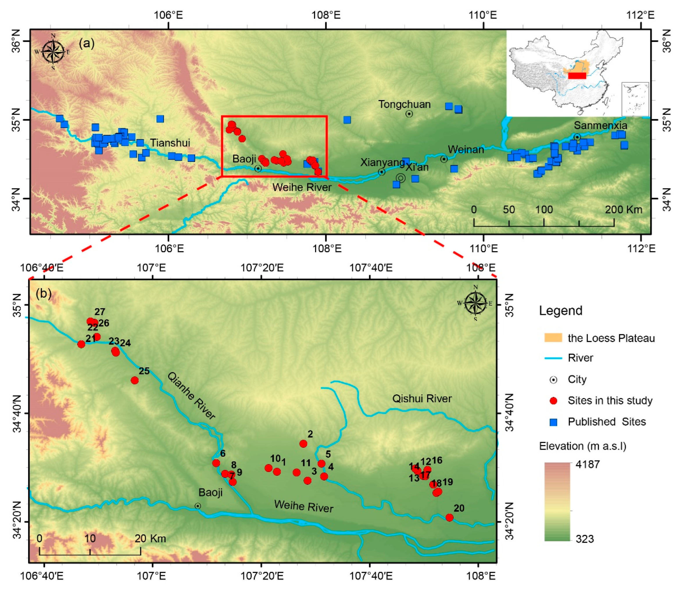
2. Study Area
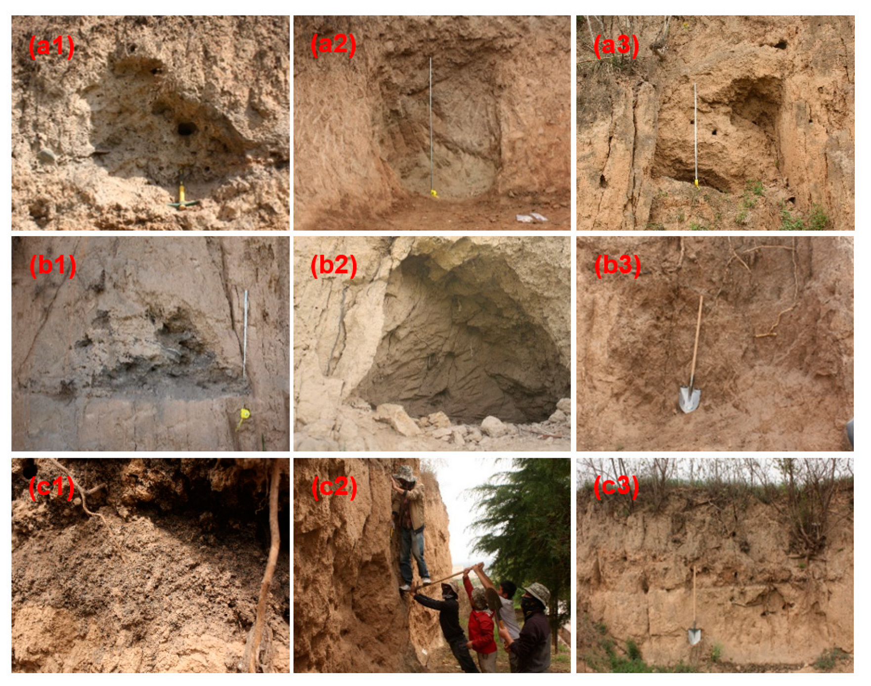
3. Materials and Methods
3.1. Archaeobotanical Methods
3.2. Radiocarbon Dating
3.3. Data Analysis
4. Results
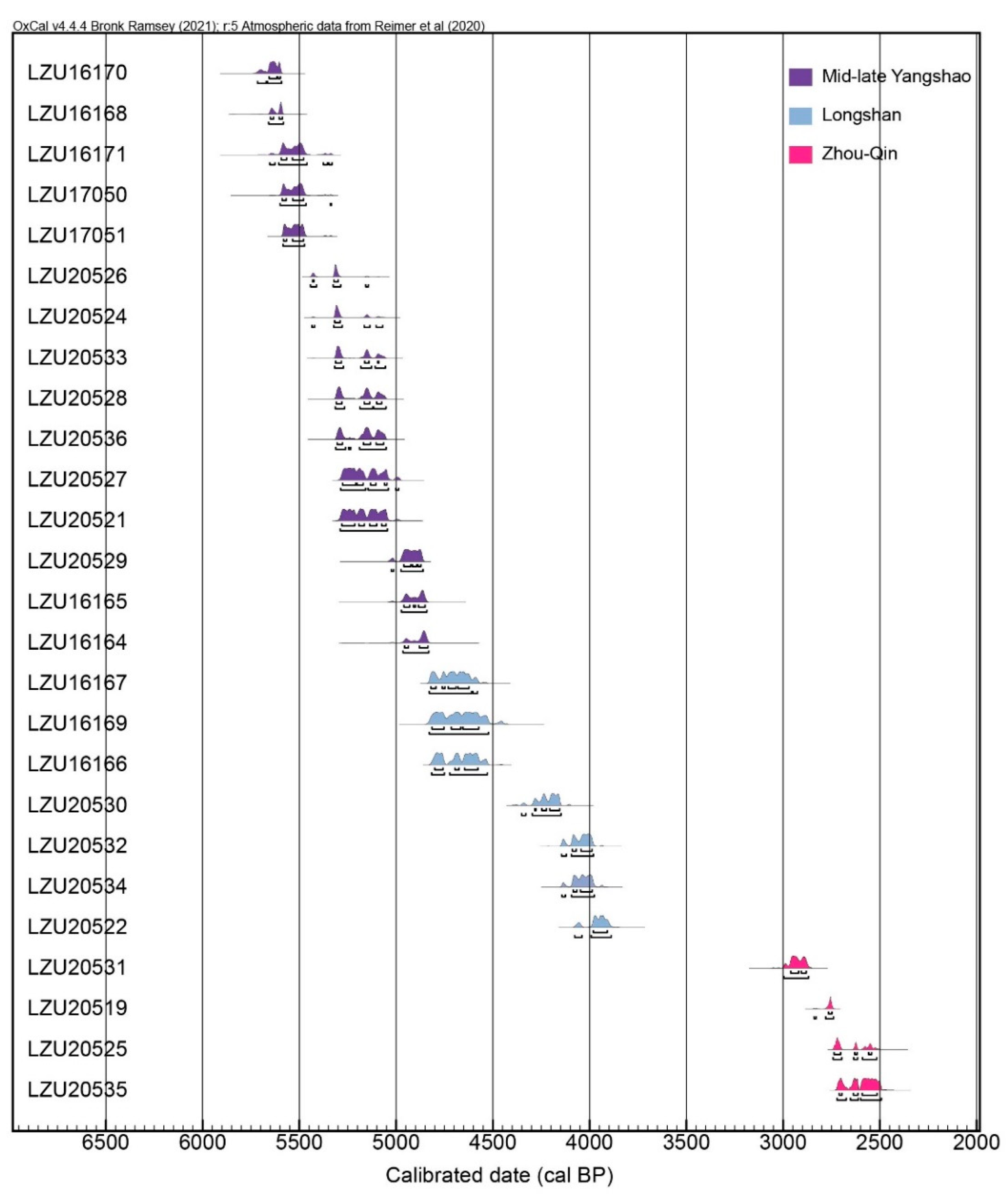
4.1. Radiocarbon Dating Results
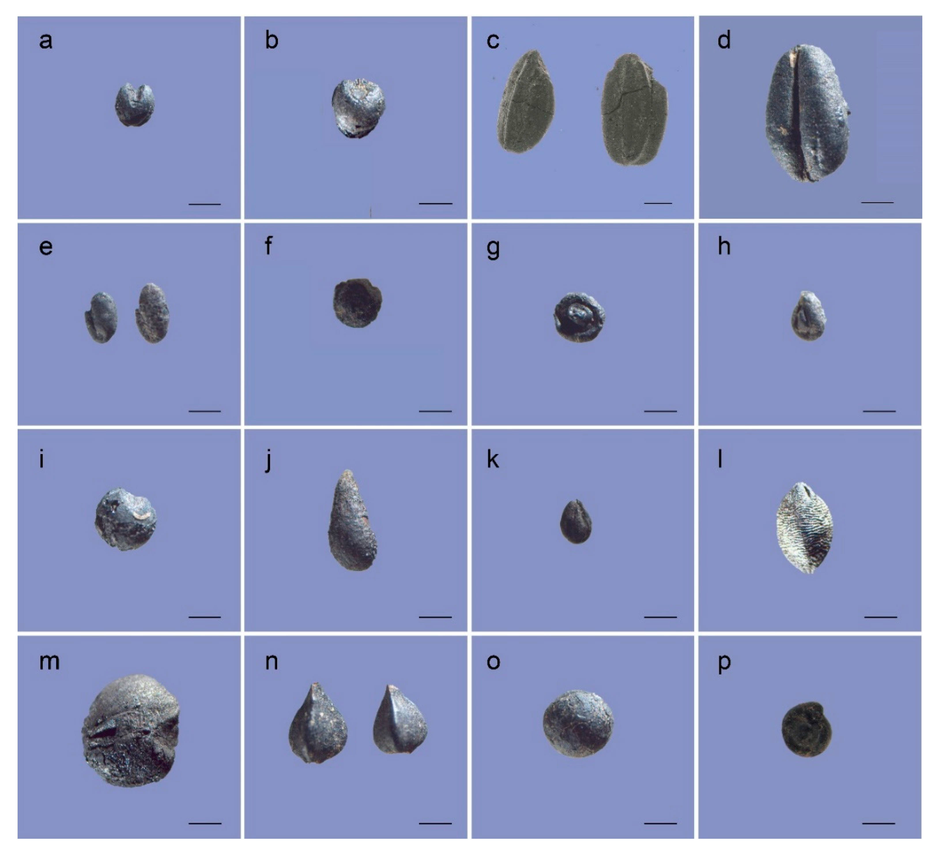
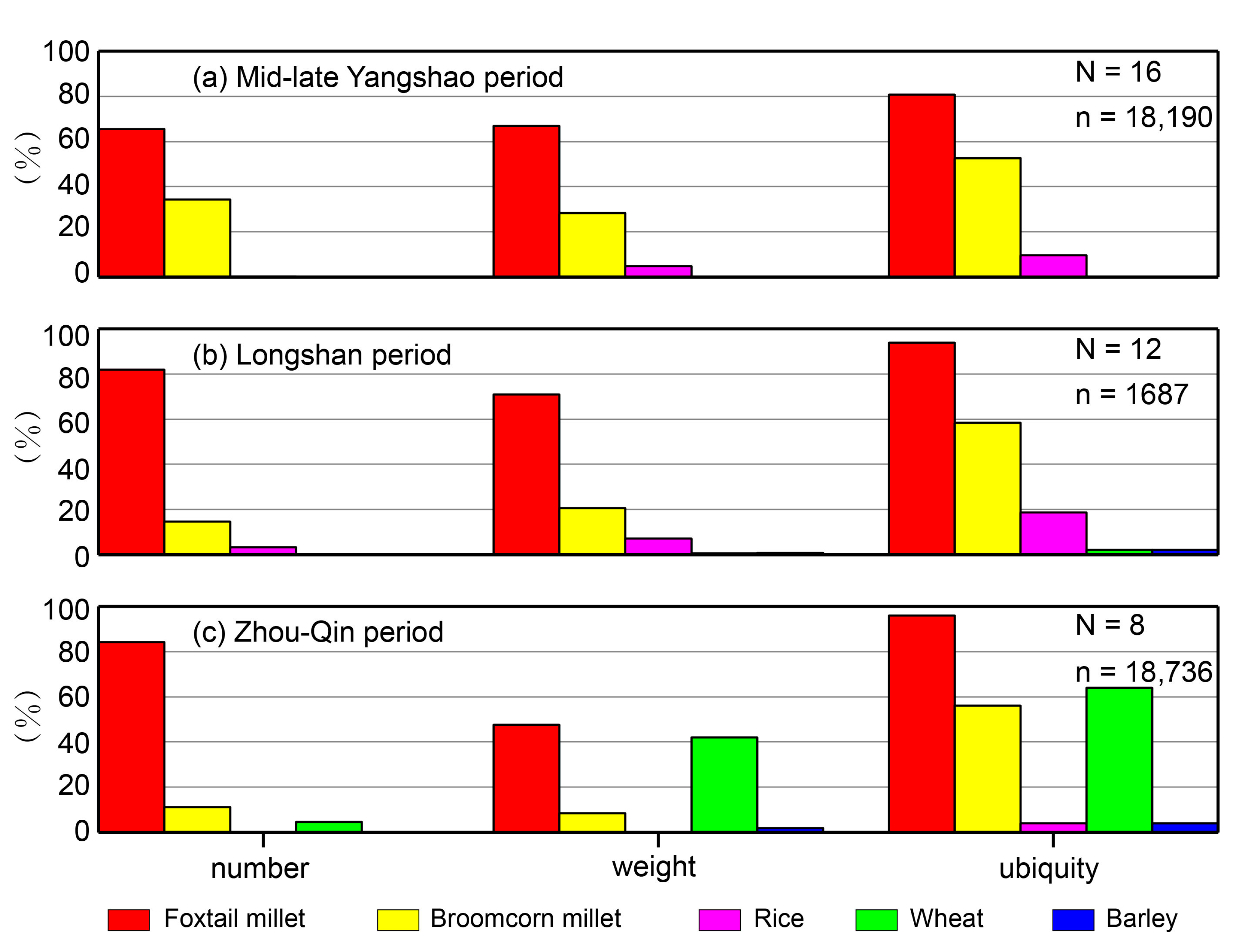
4.2. Archaeobotanical Analysis Results
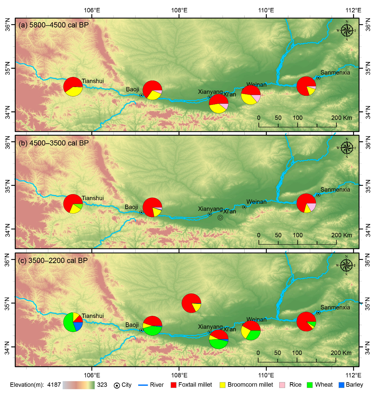
4.3. Quantitative Reconstruction of the Ancient Cropping Patterns in Baoji
5. Discussion
5.1. Geographical Shifts in Cropping Patterns from 5800 to 2200 cal BP on the SLP
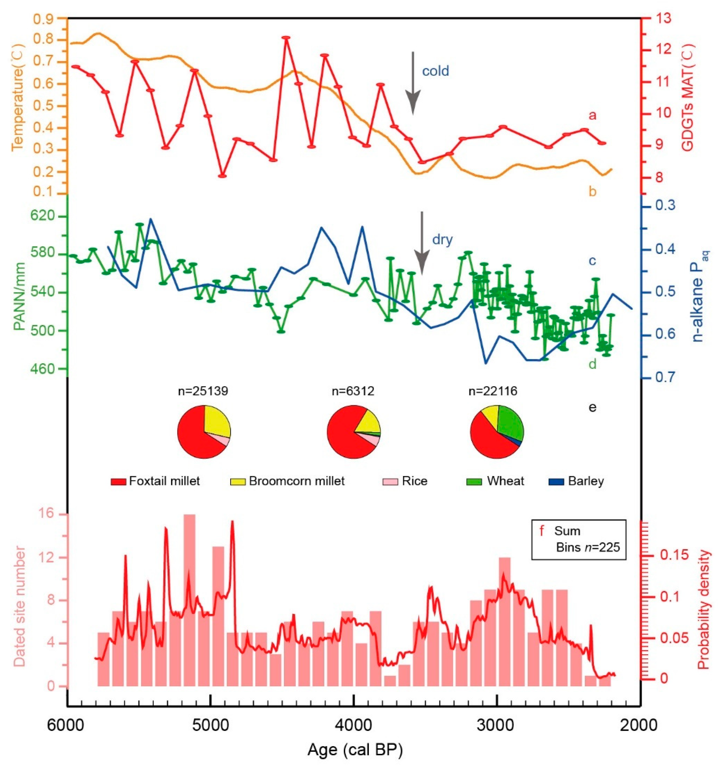
5.2. Factors influencing Spatiotemporal Variation in Cropping Patterns from 5800–2200 cal BP on the SLP
6. Summary
Supplementary Materials
Author Contributions
Funding
Institutional Review Board Statement
Informed Consent Statement
Data Availability Statement
Acknowledgments
Conflicts of Interest
References
- Jones, M.K.; Liu, X.Y. Origins of agriculture in East Asia. Science 2009, 324, 730–731. [Google Scholar] [CrossRef] [PubMed]
- Chen, F.H.; Dong, G.H.; Zhang, D.J.; Liu, X.Y.; Jia, X.; An, C.B.; Ma, M.M.; Xie, Y.W.; Barton, L.; Ren, X.Y.; et al. Agriculture facilitated permanent human occupation of the Tibetan Plateau after 3600 B.P. Science 2015, 347, 248–250. [Google Scholar] [CrossRef] [PubMed]
- Frachetti, M.D.; Smith, C.E.; Traub, C.M.; Williams, T. Nomadic ecology shaped the highland geography of Asia’s silk roads. Nature 2017, 543, 193–198. [Google Scholar] [CrossRef] [PubMed]
- Bao, Y.G.; Zhou, X.Y.; Liu, H.B.; Hu, S.M.; Zhao, K.L.; Atahan, P.; Dodson, J.; Li, X.Q. Evolution of prehistoric dryland agriculture in the arid and semi-arid transition zone in northern China. PLoS ONE 2018, 13, e0198750. [Google Scholar] [CrossRef]
- Liu, X.Y.; Jones, P.J.; Matuzeviciute, G.M.; Hunt, H.V.; Lister, D.L.; An, T.; Przelomska, N.; Kneale, C.J.; Zhao, Z.J.; Jones, M.K. From ecological opportunism to multi-cropping: Mapping food globalisation in prehistory. Quat. Sci. Rev. 2019, 206, 21–28. [Google Scholar] [CrossRef]
- Chang, C.; Ivanov, S.S.; Tourtellotte, P.A.; Spengler, R.N., III.; Mir-Makhamad, B.; Kramar, D. Ancient Agricultural and Pastoral Landscapes on the South Side of Lake Issyk-Kul: Long-Term Diachronic Analysis of Changing Patterns of Land Use, Climate Change, and Ritual Use in the Juuku and Kizil Suu Valleys. Land 2022, 11, 902. [Google Scholar] [CrossRef]
- Dong, G.H.; Du, L.Y.; Yang, L.; Lu, M.X.; Qiu, M.H.; Li, H.M.; Ma, M.M.; Chen, F.H. Dispersal of crop-livestock and geographical-temporal variation of subsistence along the Steppe and Silk Roads across Eurasia in prehistory. Sci. China Earth Sci. 2022, 65, 1187–1210. [Google Scholar] [CrossRef]
- Dong, G.H.; Li, R.; Lu, M.X.; Zhang, D.J.; James, N. Evolution of human-environmental interactions in China from the Late Paleolithic to the Bronze Age. Prog. Phys. Geogr. Earth Environ. 2020, 44, 233–250. [Google Scholar] [CrossRef]
- Dong, G.H.; Lu, Y.X.; Zhang, S.J.; Huang, X.Z.; Ma, M.M. Spatiotemporal variation in human settlements and their interaction with living environments in Neolithic and Bronze Age China. Prog. Phys. Geogr. Earth Environ. 2022, 46, 949–967. [Google Scholar] [CrossRef]
- Gignoux, C.R.; Henn, B.M.; Mountain, J.L. Rapid, global demographic expansions after the origins of agriculture. Proc. Natl. Acad. Sci. USA 2011, 108, 6044–6049. [Google Scholar] [CrossRef]
- Zhang, J.P.; Lu, H.Y.; Gu, W.F.; Wu, N.Q.; Zhou, K.S.; Hu, Y.Y.; Xin, Y.J.; Wang, C. Early Mixed Farming of Millet and Rice 7800 Years Ago in the Middle Yellow River Region, China. PLoS ONE 2012, 7, e52146. [Google Scholar] [CrossRef]
- Yan, W.M. The Origin of Agriculture and Civilization; Science Press: Beijing, China, 2000; pp. 50–89. (In Chinese) [Google Scholar]
- Li, Y.C.; Tian, J.Y.; Liu, F.W.; Yang, B.Y.; Gu, K.S.Y.; Rahman, Z.U.; Yang, L.Q.; Chen, F.H.; Dong, G.H.; Kong, Q.P. Neolithic millet farmers contributed to the permanent settlement of the Tibetan Plateau by adopting barley agriculture. Natl. Sci. Rev. 2019, 6, 1005–1013. [Google Scholar] [CrossRef]
- Sheng, P.F.; Shang, X.; Sun, Z.Y.; Yang, L.P.; Guo, X.N.; Jones, M.K. North-south patterning of millet agriculture on the Loess Plateau: Late Neolithic adaptations to water stress, NW China. Holocene 2018, 28, 1554–1563. [Google Scholar] [CrossRef]
- Li, H.M.; Cui, Y.F.; James, N.; Ritchey, M.; Liu, F.W.; Zhang, J.N.; Ma, M.M.; Dong, G.H. Spatiotemporal variation of agricultural patterns in different geomorphologic and climatic environments in the eastern Loess Plateau, north-central China during the late Neolithic and Bronze Ages. Sci. China Earth Sci. 2022, 65, 934–948. [Google Scholar] [CrossRef]
- Cai, Y.J.; Tan, L.C.; Cheng, H.; An, Z.S.; Edwards, R.L.; Kelly, M.J.; Kong, X.G.; Wang, X.F. The variation of summer monsoon precipitation in central China since the last deglaciation. Earth Planet Sci. Lett. 2010, 291, 21–31. [Google Scholar] [CrossRef]
- Chen, F.H.; Xu, Q.H.; Chen, J.H.; Birks, H.J.B.; Liu, J.B.; Zhang, S.R.; Jin, L.Y.; An, C.B.; Telford, R.J.; Cao, X.Y.; et al. East Asian summer monsoon precipitation variability since the Last Deglaciation. Sci. Rep. 2015, 5, 11186. [Google Scholar] [CrossRef] [PubMed]
- Tan, Z.H.; Han, Y.M.; Cao, J.J.; Huang, C.C.; An, Z.S. Holocene wildfire history and human activity from high-resolution charcoal and elemental black carbon records in the Guanzhong Basin of the Loess Plateau, China. Quat. Sci. Rev. 2015, 109, 76–87. [Google Scholar] [CrossRef]
- Dong, G.H.; Yang, Y.S.; Han, J.Y.; Wang, H.; Chen, F.H. Exploring the history of cultural exchange in prehistoric Eurasia from the perspectives of crop diffusion and consumption. Sci. China Earth Sci. 2017, 60, 1110–1123. [Google Scholar] [CrossRef]
- Zhang, C.; Pollard, A.M.; Rawson, J.; Huan, L.M.; Liu, R.L.; Tang, X.J. China’s major Late Neolithic centres and the rise of Erlitou. Antiquity 2019, 93, 588–603. [Google Scholar] [CrossRef]
- Barton, L.; Newsome, S.D.; Chen, F.H.; Wang, H.; Guilderson, T.P.; Bettinger, R.L. Agricultural origins and the isotopic identity of domestication in northern China. Proc. Natl. Acad. Sci. USA 2009, 106, 5523–5528. [Google Scholar] [CrossRef]
- Lu, H.Y.; Zhang, J.P.; Liu, K.B.; Wu, N.Q.; Li, Y.M.; Zhou, K.S.; Ye, M.L.; Zhang, T.Y.; Zhang, H.J.; Yang, X.Y.; et al. Earliest domestication of common millet (Panicum miliaceum) in East Asia extended to 10,000 years ago. Proc. Natl. Acad. Sci. USA 2009, 106, 7367–7372. [Google Scholar] [CrossRef] [PubMed]
- Zhao, Z.J. New archaeobotanic data for the study of the origins of agriculture in China. Curr. Anthr. 2011, 52, 295–306. [Google Scholar] [CrossRef]
- Bureau of National Cultural Relics. Atlas of Chinese Cultural Relics-Fascicule; Surveying and Mapping Press: Beijing, China, 2010. (In Chinese) [Google Scholar]
- Dong, G.H.; Liu, F.W.; Yang, Y.S.; Wang, L.; Chen, F.H. Cultural expansion and its influencing factors during Neolithic period in the Yellow River valley, northern China. China J. Nat. 2016, 38, 248–252. (In Chinese) [Google Scholar]
- Lee, G.A.; Crawford, G.W.; Liu, L.; Chen, X.C. Plants and people from the early Neolithic to Shang periods in North China. Proc. Natl. Acad. Sci. USA 2007, 104, 1087–1092. [Google Scholar] [CrossRef]
- Qu, Y.T.; Hu, K.; Yang, M.M.; Cui, J.X. Biological evidence for human subsistence strategy in the Guanzhong area during the Neolithic Period. Acta Anthr. Sin 2018, 37, 96–109. (In Chinese) [Google Scholar]
- Yang, Y.S.; Wang, J.; Li, G.; Dong, J.J.; Cao, H.H.; Ma, M.M.; Chen, G.K.; Dong, G.H. Shift in subsistence crop dominance from broomcorn millet to foxtail millet around 5500 BP in the western Loess Plateau. Front. Plant Sci. 2022, 13, 939340. [Google Scholar] [CrossRef]
- Liu, X.Y.; Lister, D.L.; Zhao, Z.J.; Petrie, C.A.; Zeng, X.S.; Jones, P.J.; Staff, R.A.; Pokharia, A.K.; Bates, J.; Singh, R.N.; et al. Journey to the east: Diverse routes and variable flowering times for wheat and barley en route to prehistoric China. PLoS ONE 2017, 12, e0187405. [Google Scholar] [CrossRef]
- Zhao, Z.J. Characteristics of agricultural economy during the formation of ancient Chinese Civilization. J. Natl. Mus. China 2011, 1, 19–31. (In Chinese) [Google Scholar]
- Zhao, Z.J. The process of origin of agriculture in China: Archaeological evidence from flotation results. Quat. Sci. 2014, 34, 73–84. (In Chinese) [Google Scholar]
- Jia, X.; Dong, G.H.; Li, H.; Brunson, K.; Chen, F.H.; Ma, M.M.; Wang, H.; An, C.B.; Zhang, K. The development of agriculture and its impact on cultural expansion during the late Neolithic in the western Loess Plateau, China. Holocene 2013, 23, 85–92. [Google Scholar] [CrossRef]
- Zhou, X.Y.; Li, X.Q.; Dodson, J.; Zhao, K.L. Rapid agricultural transformation in the prehistoric Hexi corridor, China. Quat. Int. 2016, 426, 33–41. [Google Scholar]
- Dong, G.H.; Yang, Y.S.; Liu, X.Y.; Li, H.M.; Cui, Y.F.; Wang, H.; Chen, G.K.; Dodson, J.; Chen, F.H. Prehistoric trans-continental cultural exchange in the Hexi corridor, northwest China. Holocene 2018, 28, 621–628. [Google Scholar] [CrossRef]
- Wang, X.; Shang, X.; Jiang, H.E.; Wang, C.P.; Wang, W.L.; Wang, C.S. The analysis of flotation result of carbonized seeds recovered from two sites in Baishui River valley, Shaanxi Province. Archaeol. Cult. Relics 2015, 2, 100–104. (In Chinese) [Google Scholar]
- He, K.Y.; Lu, H.Y.; Zhang, J.P.; Wang, C.; Huan, X.J. Prehistoric evolution of the dualistic structure mixed rice and millet farming in China. Holocene 2017, 27, 1885–1898. [Google Scholar] [CrossRef]
- Gong, J.F.; Wang, Y.R. Response of climate in Loess Plateau in China to global change. Agricul. Res. Arid Areas 2015, 23, 6–11. [Google Scholar]
- Qian, L.Q. Climate of Chinese Loess Plateau; China Meteorological Press: Beijing, China, 1991. (In Chinese) [Google Scholar]
- Chan, D.; Wu, Q.; Jiang, G.X.; Dai, X.L. Projected shifts in Köppen climate zones over China and their temporal evolution in CMIP5 multi-model simulations. Adv. Atmos. Sci. 2016, 33, 283–293. [Google Scholar] [CrossRef]
- Shi, Z.M. Natural Conditions and Natural Resources in Henan; Henan Science and Technology Press: Zhengzhou, China, 1983; pp. 5–202. (In Chinese) [Google Scholar]
- Dai, X.M. Evolution of the Neolithic cultural Pattern in the Yellow River Valley. Acta Archaeol. Sin. 1998, 4, 389–418. [Google Scholar]
- Brock, F.; Higham, T.; Ditchfield, P.; Ramsey, C.B. Current pretreatment methods for AMS radiocarbon dating at the Oxford Ra-diocarbon Accelerator Unit (ORAU). Radiocarbon 2010, 52, 103–112. [Google Scholar] [CrossRef]
- Cao, H.H.; Wang, Z.L.; He, J.H.; Guo, J.L.; Jull, A.J.T.; Zhou, A.F.; Dong, G.H.; Chen, F.H. Performance and inter-comparison tests of the MICADAS at the radiocarbon laboratory of Lanzhou University, China. Radiocarbon 2022. [Google Scholar] [CrossRef]
- Bronk, R. OxCal. v4. 4. 4. 2021. Available online: https://c14.arch.ox.ac.uk/oxcal/OxCal.html (accessed on 20 November 2020).
- Reimer, P.J.; Austin, W.E.N.; Bard, E.; Bayliss, A.; Black, W.; Ramsey, C.B.; Butzin, M.; Cheng, H.; Edwards, R.L.; Friedrich, M.; et al. The IntCal20 Northern Hemisphere radiocarbon age calibration curve (0–55 cal kBP). Radiocarbon 2020, 62, 725–757. [Google Scholar] [CrossRef]
- Zhao, Z.J. Paleoethnobotany: Theories, Methods and Practice; Science Press: Beijing, China, 2010. (In Chinese) [Google Scholar]
- Liu, H.; Hu, S.M.; Zhang, P.C.; Yang, Q.H.; Jiang, H.E.; Wang, W.L.; Wang, C.S. Results of soil samples flotation from two Yangshao sites in Shaanxi and a comparative study. Archaeol. Cult. Relics 2013, 4, 106–112. (In Chinese) [Google Scholar]
- Zhang, J.P.; Lu, H.Y.; Wu, N.Q.; Li, F.J.; Yang, X.Y.; Wang, W.L.; Ma, M.Z.; Zhang, X.H. Phytolith evidence for rice cultivation and spread in Mid-Late Neolithic archaeological sites in central North China. Boreas 2010, 39, 592–602. [Google Scholar] [CrossRef]
- Zhouyuan Archaeological Working Team. The excavation of the bronze casting remains in locus west of Zhuangli village at Zhouyuan site in the springs of 2003 and 2004. Acta Archaeol. Sin. 2011, 2, 245–316. (In Chinese) [Google Scholar]
- Zhong, H.; Yang, Y.C.; Shao, J.; Zhao, Z.J. The Research on the Remains of the Carbonized Plant in the New Street Site, Lantian County, Shaanxi Province. Cult. Relics South China 2015, 8. (In Chinese) [Google Scholar] [CrossRef]
- Yang, L.; Ma, M.M.; Chen, T.T.; Cui, Y.F.; Chen, P.P.; Zheng, L.C.; Lu, P. How did trans-Eurasian exchanges affect spatial-temporal variation in agricultural patterns during the late prehistoric period in the Yellow River valley (China)? Holocene 2021, 31, 247–257. [Google Scholar] [CrossRef]
- Wang, X.G. The climatic change and the early rice cultivation in the middle and lower reaches of the Yellow River. Agric. Hist. China 2011, 30, 3–12. (In Chinese) [Google Scholar]
- Zhou., X.Y.; Yu, J.J.; Spengler, R.N.; Shen, H.; Li, X.Q. 5200-year-old cereal grains from the eastern Altai Mountains redate the trans-Eurasian crop exchange. Nat. Plants 2020, 6, 78–87. [Google Scholar] [CrossRef]
- Rawson, J.; Huan, L.M.; Taylor, W.T.T. Seeking Horses: Allies, Clients and Exchanges in the Zhou Period (1045–221 BC). J. World Prehist. 2021, 34, 489–530. [Google Scholar] [CrossRef]
- Ma, M.; Lu, M.X.; Zhang, S.J.; Min, R.; Dong, G.H. Asynchronous transformation of human livelihoods in key regions of the trans-Eurasia exchange in China during 4000–2200 BP. Quat. Sci. Rev. 2022, 291, 107665. [Google Scholar] [CrossRef]
- Hageman, J.B.; Goldstein, D.J. An integrated assessment of archaeobotanical recovery methods in the Neotropical rainforest of northern Belize: Flotation and dry screening. J. Archaeol. Sci. 2009, 36, 2841–2852. [Google Scholar] [CrossRef]
- Gaudzinski-Windheuser, S.; Kindler, L. Research perspectives for the study of Neandertal subsistence strategies based on the analysis of archaeozoological assemblages. Quat. Int. 2012, 247, 59–68. [Google Scholar] [CrossRef]
- Lu, H.Y. New methods and progress in research on the origins and evolution of prehistoric agriculture in China. Sci. China Earth Sci. 2017, 60, 2141–2159. [Google Scholar] [CrossRef]
- Zhou., X.Y.; Li, X.Q.; Zhao, K.L.; Dodson, J.; Sun, N.; Yang, Q. Early agricultural development and environmental effects in the Neolithic Longdong Basin (eastern Gansu). China Sci. Bull. 2011, 56, 762–771. [Google Scholar] [CrossRef]
- Li, X.Q.; Zhou, X.Y.; Zhou, J.; Dodson, J.; Zhang, H.; Shang, X. The earliest archaeobiological evidence of the broadening agriculture in China recorded at Xishanping site in Gansu Province. Sci. China Earth Sci. 2007, 50, 1707–1714. [Google Scholar] [CrossRef]
- Dong, Y.; Morgan, C.; Chinenov, Y.; Zhou, L.G.; Fan, W.Q.; Ma, X.L.; Pechenkina, K. Shifting diets and the rise of male-biased inequality on the Central Plains of China during Eastern Zhou. Proc. Natl. Acad. Sci. USA 2017, 114, 932–937. [Google Scholar] [CrossRef]
- Chen, X.L.; Wu, Y.H.; Li, Z.P. Subsistence around 3rd millennium B.C. in Luoyang basin evidenced by human diets at Zhonggou and Wanggedang sites. Quat. Sci. 2019, 39, 197–208. [Google Scholar]
- Guo, Y.; Xia, Y.; Dong, Y.F.; Yu, B.Y.; Fan, Y.L.; Wen, F.Y.; Gao, Q. Stable Isotopic Analysis of Human Remains from the Beiliu Site. Archaeol. Cult Relics 2016, 1, 115–120. [Google Scholar]
- Zhang, X.J.; Qiu, S.H.; Zhong, J.; Zhao, X.P.; Sun, F.X.; Chen, L.Q.; Guo, Y.Q.; Li, X.W.; Ma, X.L. Studies on Diet of the Ancient People of the Yangshao Cultural Sites in the Central Plains. Acta Anat. Sin. 2010, 29, 197–207. [Google Scholar]
- Zeder, M.A. Domestication and early agriculture in the Mediterranean Basin: Origins, diffusion, and impact. Proc. Natl. Acad. Sci. USA 2018, 105, 11597–11604. [Google Scholar] [CrossRef]
- Riehl, S.; Zeidi, M.; Conard, N.J. Emergence of agriculture in the foothills of the Zagros Mountains of Iran. Science 2013, 341, 65–67. [Google Scholar] [CrossRef]
- Zhao, Z.J.; Wang, W.; Xu, X.G.; Niu, S.S.; Cai, L.H.; Song, J.N.; Xiao, Y.M.; Zhang, C.S.; Yang, J.G. Analysis of flotation results of the Cayue Cultural Site at Fengtai in Qinghai Province. Archaeol. Cult Relics 2004, 2, 85–91. (In Chinese) [Google Scholar]
- Yang, Y. The Analysis of Charred Plant Seeds at Jinchankou Site and Lijiaping Site during Qijia Culture Period in the Hehuang Region, China. Master’s Thesis, Lanzhou University, Lanzhou, China, 2014. (In Chinese). [Google Scholar]
- Chen, T.T.; Qiu, M.H.; Liu, R.L.; Li, H.M.; Zhou, A.F. Human responses to climate change in the late prehistoric western loess plateau, northwest China. Radiocarbon 2020, 62, 1193–1207. [Google Scholar] [CrossRef]
- Liu, X.Y. Study on the Plant Remains EXCAVATED in Anban site in 2012. Master’s Thesis, Northwest University, Xi’an, China, 2014. (In Chinese). [Google Scholar]
- Zhao, Z.J. Agricultural Economics Research of 2500 BCE–1500 BCE in Central Plains. In Keji Kaogu (Science for Archaeology); Science Press: Beijing, China, 2007; Volume 2, pp. 1–11. (In Chinese) [Google Scholar]
- Wang, Q.; Wang, L.Z. The Discovery of a Longshan Period City Site in Henan. Zhongguo Wenwubao (China Cultural Relics News) 2008, 28, 1. [Google Scholar]
- Huang, S.L. Wheat (culms) unearthed from Longshan Cultural Site, Shaanxi Province. Agricul Archaeol 1991, 1, 118–120. (In Chinese) [Google Scholar]
- Dodson, J.R.; Li, X.Q.; Zhou, X.Y.; Zhao, K.L.; Sun, N.; Atahan, P. Origin and spread of wheat in China. Quat. Sci. Rev. 2013, 72, 108–111. [Google Scholar] [CrossRef]
- Jia, X.; Sun, Y.G.; Wang, L.; Sun, W.F.; Zhao, Z.J.; Lee, H.F.; Huang, W.B.; Wu, S.Y.; Lu, H.Y. The transition of human subsistence strategies in relation to climate change during the Bronze Age in the West Liao River Basin, Northeast China. Holocene 2016, 26, 781–789. [Google Scholar] [CrossRef]
- Roffet-Salque, M.; Marciniak, A.; Valdes, P.J.; Pawlowska, K.; Pyzel, J.; Czerniak, L.; Krüger, M.; Roberts, C.N.; Pitter, S.; Evershed, R.P. Evidence for the impact of the 8.2-kyBP climate event on Near Eastern early farmers. Proc. Natl. Acad. Sci. USA 2018, 115, 8705–8709. [Google Scholar] [CrossRef]
- Wang, Z.K.; Ding, Y.; Liu, J.S. Brief report of M4 excavation at Shigushan Shang-Zhou Cemetery in Baoji, Shaanxi Province. Cult. Relics 2016, 1, 49. [Google Scholar]
- Festa, M.; Monteith, F. Between Plain and Plateau: Micro-Transitions in Zooarchaeological Landscapes in the Guanzhong Region of Northwest China. Land 2022, 11, 1269. [Google Scholar] [CrossRef]
- Cramp, L.J.E.; Ethier, J.; Urem-Kotsou, D.; Bonsall, C.; Borić, D.; Boroneanţ, A.; Evershed, R.P.; Perić, S.; Roffet-Salque, M.; Whelton, H.L.; et al. Regional diversity in subsistence among early farmers in Southeast Europe revealed by archaeological organic residues. Proc. R Soc. B 2019, 286, 20182347. [Google Scholar] [CrossRef]
- Tan, L.C.; Dong, G.H.; An, Z.S.; Edwards, R.L.; Li, H.M.; Li, D.; Spengler, R.; Cai, Y.J.; Cheng, H.; Lan, J.H.; et al. Megadrought and cultural exchange along the proto-silk road. Sci. Bull. 2021, 66, 603–611. [Google Scholar] [CrossRef]
- Li, R.; Lu, F.Y.; Yang, L.; Liu, F.W.; Liu, R.L.; Dong, G.H. Spatial–Temporal Variation of Cropping Patterns in Relation to Climate Change in Neolithic China. Atmosphere 2020, 11, 677. [Google Scholar] [CrossRef]
- Liu, G.E.; Xiang, A.Q. Discussion on the prehistorical south rice-north millet blended zone and its genesis. Agric. Archaeol. 2005, 1, 115–122. [Google Scholar]
- D’Alpoim, G.J. Rethinking the spread of agriculture to the Tibetan Plateau. Holocene 2015, 25, 1498–1510. [Google Scholar] [CrossRef]
- Weber, S.; Lehman, H.; Barela, T.; Hawks, S.; Harriman, D. Rice or millets: Early farming strategies in prehistoric central Thailand. Archaeol. Anthr. Sci. 2010, 2, 79–88. [Google Scholar] [CrossRef]
- Shrestha, S.; Chapagain, R.; Babel, M.S. Quantifying the impact of climate change on crop yield and water footprint of rice in the Nam Oon Irrigation Project, Thailand. Sci. Total. Environ. 2017, 599–600, 689–699. [Google Scholar] [CrossRef]
- Liao, Y.N.; Lu, P.; Mo, D.W.; Wang, H.; Storozum, M.J.; Chen, P.P.; Xu, J.J. Landforms influence the development of ancient agriculture in the Songshan area, central China. Quat. Int. 2019, 512, 85–89. [Google Scholar] [CrossRef]
- Li, Y.P.; Zhang, J.N. The influence of landscape evolution on rice planting in the middle-late Neolithic period to Xia-Shang dynasties in Luoyang Basin. Quat. Sci. Rev. 2020, 40, 499–511. [Google Scholar]
- van der Veen, M. Agricultural innovation: Invention and adoption or change and adaptation? World Archaeol. 2010, 42, 1–12. [Google Scholar] [CrossRef]
- Boivin, N.; Fuller, D.Q.; Crowther, A. Old World globalization and the Columbian exchange: Comparison and contrast. World Archaeol. 2012, 44, 452–469. [Google Scholar] [CrossRef]
- Anthony, D.W. The Horse, the Wheel, and Language: How Bronze-Age Riders from the Eurasian Steppes Shaped the Modern World; Princeton University Press: Princeton, NJ, USA, 2010; pp. 121–456. [Google Scholar]
- Kuz’mina, E.E. The Prehistory of the Silk Road; University of Pennsylvania Press: Philadelphia, PA, USA, 2008; pp. 39–108. [Google Scholar]
- Hou, L.L.; Hu, Y.W.; Zhao, X.P.; Li, S.T.; Wei, D.; Hou, Y.F.; Hu, B.H.; Lu, P.; Li, T.; Song, G.D.; et al. Human subsistence strategy at Liuzhuang site, Henan, China during the proto-Shang culture (~2000–1600 BC) by stable isotopic analysis. J. Archaeol. Sci. 2013, 40, 2344–2351. [Google Scholar] [CrossRef]
- Hou, L.L.; Zhao, J.; Deng, H.; Chen, X.; Chen, T.; Tao, D.; Guo, Y. The subsistence patterns of Xinding Basin, Shanxi, China during ~4000 yr BP by stable isotopes and plant microfossils analysis. Sci. China Ser D-Earth Sci. 2020, 50, 369–379. (In Chinese) [Google Scholar]
- Marcott, S.A.; Shakun, J.D.; Clark, P.U.; Mix, A.C. A reconstruction of regional and global temperature for the past 11,300 years. Science 2013, 339, 1198–1201. [Google Scholar] [CrossRef] [PubMed]
- Zhao, Y.; Yu, Z.C. Vegetation response to Holocene climate change in East Asian monsoon-margin region. Earth Sci. Rev. 2012, 113, 1–10. [Google Scholar] [CrossRef]
- Li, X.Q.; Shang, X.; Dodson, J.; Zhou, X.Y. Holocene agriculture in the Guanzhong Basin in NW China indicated by pollen and charcoal evidence. Holocene 2009, 19, 1213–1220. [Google Scholar] [CrossRef]
- Liu, Z.H.; Yang, P.; Tang, H.J.; Wu, W.B.; Zhang, L.; Yu, Q.Y.; Li, Z.G. Shifts in the extent and location of rice cropping areas match the climate change pattern in China during 1980–2010. Reg. Env. Change 2015, 15, 919–929. [Google Scholar] [CrossRef]
- Zeng, X.S. On the spread of wheat in ancient China. J. Chin. Dietary Cul. 2005, 1, 99–133. (In Chinese) [Google Scholar]
- Zhou, L.G.; Garvie-Lok, S.J. Isotopic evidence for the expansion of wheat consumption in northern China. Archaeol. Res. Asia 2015, 4, 25–35. [Google Scholar] [CrossRef]
- Sun, H.L. Palaeoenvironment Reconstruction of the Middle to Late Holocene in a High-Resolution Sediment Core from Tianchi Lake on Liupan Mountain. Ph.D. Thesis, Lanzhou University, Lanzhou, China, 2011; pp. 77–89. (In Chinese). [Google Scholar]
- Sun, H.L.; Bendle, J.; Seki, O.; Zhou, A.F. Mid-tolate Holocene hydroclimatic changes on the Chinese Loess Plateau: Evidence from n-alkanes from the sediments of Tianchi Lake. J. Paleolimnol. 2018, 60, 511–523. [Google Scholar] [CrossRef]
- Liu, C.J.; Kong, Z.C.; Lang, S.D. Relics of crops and discussion on the environment of primitive people living in Dadiwan site. Cul Rel Cent. China 2004, 4, 26–30. (In Chinese) [Google Scholar]
- Zhouyuan Archaeological Working Team. The excavation of Zhuangli village at Zhutong site of western Zhou in the springs of 2003 and 2004. Acta Archaeol. Sin 2011, 2, 245–316. (In Chinese) [Google Scholar]
- Chen., S.Y.; Fu, W.B.; Liu, J.Q.; Tang, L.Y.; Zhai, L.L.; Zhao, Z.J.; Wen, R. Study on Remains of Carbonized Plant in Zaolin River Beach Site in Xunyi, Shaanxi Province. Cult Relics South China (In Chinese). 2019, 1, 103–112 (In Chinese). [Google Scholar]
- Tang, L.Y.; Yang, J.H.; Guo, X.; Tian, J.; Han, K.; Zhang, X.Y. Consistency and imbalance of agricultural production in the Guanzhong region in the pre-Qin period: Evidence from the Gongbeiya site in Xi’an. Cult Relics South China 2020, 4, 163–172. (In Chinese) [Google Scholar]
- Zhong, H.; Li, X.W.; Wang, W.L.; Yang, L.P.; Zhao, Z.J. Preliminary research of the farming production pattern in the Central Plain area during the Miaodigou Period. Quat Sci 2020, 40, 472–485. (In Chinese) [Google Scholar]
- Zhao, Z.J. Changes and Development of Ancient Agriculture on Weihe Plain——An Analysis of Plant Remnants Excavated from Dongyang Site in Huaxian District. Huaxia Archaeol. 2019, 15, 70–84. (In Chinese) [Google Scholar]
- Henan Provincial Institute of Cultural Relics and Archaeology; Sanmenxia Nanjiaokou Science Press: Beijing, China, 2009; pp. 316–320. (In Chinese)


| Lab Code | Sample Number | Dating Material | Dating Method | Radiocarbon | Calibrated Age (cal. yr BP) | Period | |
|---|---|---|---|---|---|---|---|
| Age (yr BP) | 1σ | 2σ | |||||
| LZU16170 | Baguankou H5 | Rice | AMS | 4925 ± 25 | 5657–5598 | 5716–5592 | Middle Yangshao |
| LZU16168 | Maizaoyu H1 | Foxtail millet | AMS | 4885 ± 25 | 5650–5588 | 5659–5582 | Middle Yangshao |
| LZU16171 | Yuanzitou H2 | Broomcorn millet | AMS | 4815 ± 50 | 5594–5478 | 5653–5331 | Middle Yangshao |
| LZU17050 | Shuigou Layer ⑨ | Foxtail millet | AMS | 4805 ± 40 | 5589–5479 | 5600–5335 | Middle Yangshao |
| LZU17051 | Wangjiazui | Broomcorn millet | AMS | 4780 ± 25 | 5582–5479 | 5585–5474 | Middle Yangshao |
| LZU20526 | Gaojiahe1 H2 | Foxtail millet | AMS | 4590 ± 20 | 5432–5300 | 5442–5144 | Middle Yangshao |
| LZU20524 | Qiyang1 H4 | Broomcorn millet | AMS | 4570 ± 20 | 5318–5289 | 5435–5070 | Middle Yangshao |
| LZU20533 | Yuanzitou H2 | Foxtail millet | AMS | 4550 ± 20 | 5313–5090 | 5318–5056 | Middle Yangshao |
| LZU20528 | Madaokou H4 | Broomcorn millet | AMS | 4540 ± 20 | 5309–5075 | 5315–5053 | Middle Yangshao |
| LZU20536 | Xinpingsi H4 | Foxtail millet | AMS | 4530 ± 20 | 5305–5065 | 5312–5052 | Middle Yangshao |
| LZU20527 | Guanmaotou H2 | Foxtail millet | AMS | 4480 ± 20 | 5277–5048 | 5287–4986 | Middle Yangshao |
| LZU20521 | Anban layer3 | Foxtail millet | AMS | 4490 ± 20 | 5280–5052 | 5289–5045 | Late Yangshao |
| LZU20529 | Xiaoyuan H3 | Foxtail millet | AMS | 4370 ± 20 | 4960–4872 | 5025–4861 | Late Yangshao |
| LZU16165 | Bianjiazhuang H2 | Rice | AMS | 4335 ± 30 | 4959–4850 | 4973–4841 | Late Yangshao |
| LZU16164 | Yuanzitou layer ② | Rice | AMS | 4310 ± 35 | 4956–4836 | 4965–4832 | Late Yangshao |
| LZU16167 | Maizaoyu H2 | Rice | AMS | 4160 ± 30 | 4821–4624 | 4828–4580 | Longshan |
| LZU16169 | Mogouyuan H4 | Rice | AMS | 4130 ± 50 | 4815–4573 | 4828–4523 | Longshan |
| LZU16166 | Xinpingsi layer ② | Rice | AMS | 4125 ± 25 | 4800–4578 | 4817–4529 | Longshan |
| LZU20530 | Yaozi’ao H4 | Foxtail millet | AMS | 3830 ± 20 | 4284–4155 | 4352–4148 | Longshan |
| LZU20532 | Yuxiang H3 | Rice | AMS | 3710 ± 20 | 4090–3988 | 4146–3981 | Longshan |
| LZU20534 | Mogouyuan H1 | Foxtail millet | AMS | 3700 ± 20 | 4085–3987 | 4144–3976 | Longshan |
| LZU20522 | Tiezhang H3 | Foxtail millet | AMS | 3640 ± 20 | 3981–3909 | 4078–3889 | Longshan |
| LZU20531 | Yaozi’ao H6 | Wheat | AMS | 2830 ± 20 | 2961–2881 | 2997–2869 | Zhouqin |
| LZU20519 | Wangjiazui H1 | Wheat | AMS | 2650 ± 20 | 2766–2748 | 2840–2740 | Zhouqin |
| LZU20525 | Daxin H5 | Wheat | AMS | 2540 ± 20 | 2737–2543 | 2742–2516 | Zhouqin |
| LZU20535 | Baguankou H4 | Wheat | AMS | 2500 ± 20 | 2710–2515 | 2722–2493 | Zhouqin |
Disclaimer/Publisher’s Note: The statements, opinions and data contained in all publications are solely those of the individual author(s) and contributor(s) and not of MDPI and/or the editor(s). MDPI and/or the editor(s) disclaim responsibility for any injury to people or property resulting from any ideas, methods, instructions or products referred to in the content. |
© 2023 by the authors. Licensee MDPI, Basel, Switzerland. This article is an open access article distributed under the terms and conditions of the Creative Commons Attribution (CC BY) license (https://creativecommons.org/licenses/by/4.0/).
Share and Cite
Yang, L.; Yang, Y.; Zhang, S.; Li, H.; Cao, H.; Cui, Y.; Liu, F.; Ma, M. Asynchronous Transformation of Cropping Patterns from 5800–2200 cal BP on the Southern Loess Plateau, China. Land 2023, 12, 343. https://doi.org/10.3390/land12020343
Yang L, Yang Y, Zhang S, Li H, Cao H, Cui Y, Liu F, Ma M. Asynchronous Transformation of Cropping Patterns from 5800–2200 cal BP on the Southern Loess Plateau, China. Land. 2023; 12(2):343. https://doi.org/10.3390/land12020343
Chicago/Turabian StyleYang, Liu, Yishi Yang, Shanjia Zhang, Haiming Li, Huihui Cao, Yifu Cui, Fengwen Liu, and Minmin Ma. 2023. "Asynchronous Transformation of Cropping Patterns from 5800–2200 cal BP on the Southern Loess Plateau, China" Land 12, no. 2: 343. https://doi.org/10.3390/land12020343
APA StyleYang, L., Yang, Y., Zhang, S., Li, H., Cao, H., Cui, Y., Liu, F., & Ma, M. (2023). Asynchronous Transformation of Cropping Patterns from 5800–2200 cal BP on the Southern Loess Plateau, China. Land, 12(2), 343. https://doi.org/10.3390/land12020343