Article

Urban Modeling in the Global South and Sustainable Socio-Territorial Development: Case of Puebla-San Andrés Cholula Urban Binomial, Mexico

by
Anne K. Kurjenoja
InLAB, Territory and Urban Artifact Research Group, Ex. Hda. Santa Catarina Mártir, Cholula 72810, Puebla, Mexico
Land 2023, 12(11), 2081; https://doi.org/10.3390/land12112081
Submission received: 9 October 2023 / Revised: 8 November 2023 / Accepted: 15 November 2023 / Published: 19 November 2023

Abstract

:
To understand urbanization across the Global South, it is indispensable to consider situated heterogeneous urban situations shaped by global and local forces and their intersections. In the case of Mexico, the political and economic desire for globalization has extended beyond the great metropolis of Mexico City to mid-size cities triggering the formulation of their own urban strategies to become global. This paper explores the connections between neoliberal public policy, globalization, urban modeling, and socio-territorial sustainability in the territorial binomial of the city of Puebla and the municipality of San Andrés Cholula in the period of 2011–2017 and its current consequences, addressed by the local planning route map, and informed by the Orange Economy-guide of the Inter-American Development Bank (IDB), using relevant bibliographical sources, mapping, interviews of stakeholders, and fieldwork. The ultimate purpose of the research project described herein is to provide a multi-dimensional analysis of the development of the territorial situation of the Puebla-San Andrés Cholula-urban binomial, and of its current and potential future consequences, offering supporting information for its urban planning. The research results exposed here reveal urban modeling processes informed by the Global North urban globalization theory, development of global cities in the Global South, local socio-territorial dynamics characterized by economic and political interests imprinted in the public policy, and socio-territorial patterns inherited from the colonial past, resulting in socio-economic and racial discrimination, population displacements, real estate speculation, and risking ecological and environmental sustainability.

1. Introduction

To study urbanization across the Global South, it is indispensable to consider situated heterogeneous urban situations shaped by global and local forces and their intersections [1,2]. In the case of Mexico, the political and economic desire for globalization has extended beyond the great metropolis of Mexico City to mid-size metropolitan areas triggering the formulation of their own urban strategies to become global.
In the postcolonial theory framework, Aihwa Ong in her Powers of sovereignty: State, people, wealth, life [1], has pointed out how the recent decades have marked a shift away from models of stabilized world arrangements, also in the case of studying urban development. Mouton and Shatkin [2] have mentioned that we should not follow the presumption of being able to explain the recent urbanization processes in the postcolonial developing world only through the Euro-American theoretical core of urban studies, as their local characteristics and conditions disrupt its all-embracing universal concepts and development patterns. Thus, lines of thought have emerged especially in Asia, to attend to the specificities and patterns of urbanization across the post-colony. As Ong [1], besides Mouton and Shatkin [2], observed that the demand for postcolonial thinking in urban studies has triggered the interest in the analysis of heterogeneous urban situations in the post-colony shaped by both global and deeply rooted local forces and their intersections. Thus, Ong [3] proposed the exploration of the global as a historically contingent concept shaped by the interactions between global and locally situated components characterized by varied political, economic, social, and cultural conditions. Mouton and Shatkin [2], citing Hart (2016) [4], have suggested that cities are not simple recipients of global processes, but agential territories and sites for their production juxtaposed with spatial-historical conjunctures. When analyzing their urban territories through a conjunctural approach, it is thought of as indispensable to study their specific spatio-temporal conditions, such as those related to a colonial past, to acquire a deep understanding of their histories of social, economic, and political change, and how these have been connected to larger structural forces, as those of globalization.
According to Shatkin [5], in the developing and postcolonial world the studies of urban globalization have been much concentrated on the megacities of the Global South and on the dramatic spatial expansion of their territory. This explosive growth has frequently meant even violent changes in the surrounding regions, transforming the habitability of large areas detonating human displacements and socio-territorial and environmental changes. The local policy informed by the global has triggered especially in Asia, the promotion of renewal plans to up-scale urban regions through the interaction between locally situated actors and the neoliberal global dynamics, giving a powerful example for other regions of the post-colony how to increment the economic and political importance of their cities in the globalizing world.
In Latin America, globalization appeared in the 1990s as a luring alternative for urban development, but the true start-up for this in Mexico began after 2007 triggered by ProMéxico, a trust of the Federal Government. Though, much of the research work done about urban transformation until now in Mexico has been concentrated on the biggest metropolitan area of the country, Mexico City, the political and economic desire for globalization reached various mid-size Mexican cities and their suburban areas since the beginning of the 21st century, reformulating their urban strategies now aiming at becoming global. Among them, there is the city of Puebla and its metropolitan area with 2,328,663 inhabitants [6], the capital of the federal state of the same name, located in the central plateau of Mexico. Under the state government of 2011–2017, Puebla aspired to be one of the Latin American global cities and as such, through an aggressive public policy, promoted urban territorial transformations and re-engineering of its image through urban modeling, expanding these interventions beyond its own limits to the territory of its Western neighbor, the rural municipality of San Andrés Cholula, thus giving origin to the development of an urban binomial.
In this context, this paper presents five initial statements it proposes to discuss, based on the 2014–2023 research work: (1) The urban development of Puebla-San Andrés Cholula-urban binomial has been influenced by the Global North and the Southeast Asian neoliberal development patterns, manifesting characteristics of both in its territorial management; (2) Regarding the creation of a global urban image, Southeastern Asian style urban and territorial modeling has been applied through public politics; (3) The local colonial history and the socio-racial discrimination has been inherited and transferred to the 21st century urban territorial management; (4) The juxtaposition of the above mentioned aspects have aggravated the already existing socio-territorial polarization observable in the urban inclusion-exclusion strategies reinforced by the urban planning processes of the 2011–2017 period, and lastly (5) The territorial processes triggered by neoliberal public policy of the mentioned period and the corresponding land management strategy have menaced the socio-territorial and environmental balance, quality of life and urban sustainability in the area of the Puebla-San Andrés Cholula-urban binomial. Thus, this article explores, at which point could we study urban binomial’s urbanization processes from the scope of development patterns of the Global North. Furthermore, could the 21st-century Latin American urbanization–metropolization be analyzed in the light of experiences and research done in other parts of the post-colony as in Southeast Asia, exploring similarities? Finally, can the Global North and the Southeast Asian influences be observed in the urban development of a Mexican mid-size metropolitan area, such as the urban binomial of the city of Puebla and the municipality of San Andrés Cholula, and juxtaposed with local conditions, public policy, and economic interests, and which have been their consequences considering the socio-territorial and environmental sustainability? As answers to these questions, this article shows how the Puebla-San Andrés Cholula urban binomial has been transformed into an agential territory in which spatial-historical conjunctures are juxtaposed with urbanization patterns informed by a neoliberal public policy, influenced by the Global North urban globalization theory and urban modeling in Asian global cities, putting thus at risk the social, ecological, and environmental sustainability.

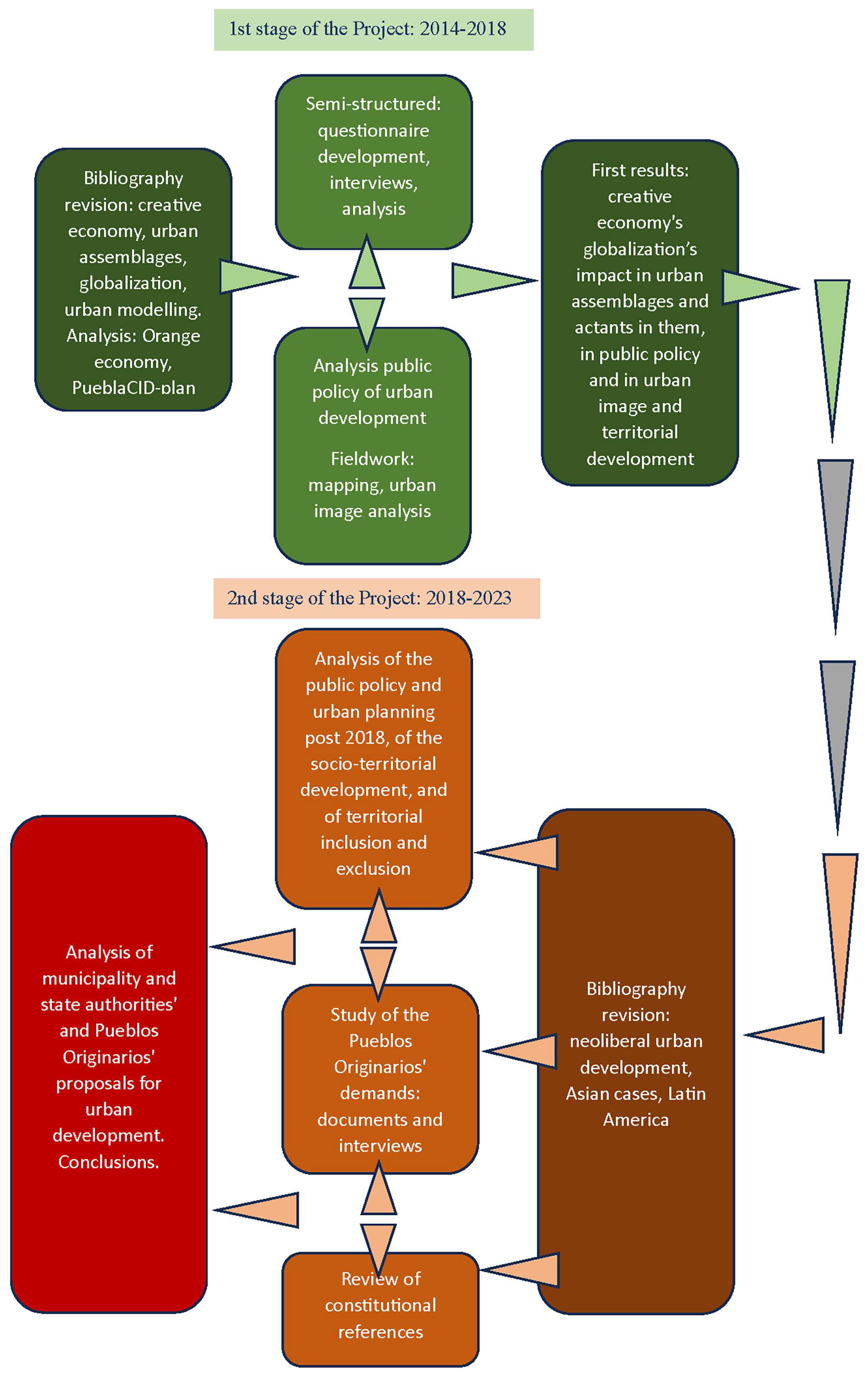
2. Materials and Methods

This paper, informed by bibliographical research, field studies, and interviews, aims to explore which has been the role of different urban actors, such as real estate developers, state government, and local stakeholders, in the re-assemblage of urban territories and development processes in Puebla-San Andrés Cholula-urban binomial, but it also explores how the local rural population of the latter has been impacted by the change and how the territorial transformations have impacted the environmental conditions and sustainability.
The article is informed by the Global North and Global South postcolonial lines of thought, revising how these localized tendencies of development have influenced the binomial’s own processes of urban transformations. Furthermore, in 2016 a series of interviews were conducted, first with the urbanists who participated in the 1990s planning processes that triggered the first stage of the neoliberal urbanization in the territory of the binomial being the basis for the second 2011–2017 stage of urban transformations. In the same year, more interviews were held with the architect, responsible for the design of various public spaces in the San Andrés Cholula territory, under the concept of urban modeling and staging.
Also, fieldwork was carried out in 2014–2016 through photographing the urban transformations in progress, besides mapping the territorial impacts. From 2018 onwards, the results and consequences of the 2011–2017 development have been observed, especially focused on the territorial conflicts and socio-environmental demands denounced by the San Andrés Cholula’s Indigenous habitants. In these terms, more interviews have been conducted with the local communities, revision of the legal framework carried out, and more fieldwork undertaken to document the socio-territorial and environmental effects of the urban transformations. The following chart of Figure 1 describes the workflow carried out:

3. Case Study

The focus area of this case study, the metropolitan area of Puebla and the border zone between it and the municipality of San Andrés Cholula, is located in central Mexico, 106 km to the Southeast of Mexico City, as presented in the following map of Figure 2.
In the following sections, the origin of San Andrés Cholula and the colonial foundation of Puebla are described, as well as their urban development until current times.

3.1. Puebla-San Andrés Cholula: Foundation, Development and Globalization of an Urban Binomial

3.1.1. Cholula: The Ancient City

Ashwell [8,9] describes how the territorial development of Cholula, today consisting of two municipalities, San Pedro and San Andrés Cholula, has been the product of a long civilizing process and human presence dating back at least 20,000 years B.C. Between the year 300 B.C. and the beginning of the Christian era, Cholula quickly transformed into a large city. At this time, the oldest pyramidal structure of the Cholultecan ceremonial center of the period 200–100 BC, Tlachihualtepetl, ‘the hill made by man’ (see Figure 3) or the Great Pyramid of Cholula dedicated to the god Quetzalcoatl, was erected representing a natural hill associated with water, tule trees and flowers [8,9].
During the colony, and despite the territorial division into two separate communities, the two Cholulteca villages, San Pedro and San Andrés, continued to maintain their customs and habits without major changes until the mid-20th century, also preserving their definition as a living altepetl, that is, a socio-spatial organization of the territory similar to many others that gave rise to many Mesoamerican cities [9,10]. Both Cholulas are characterized by different fabrics juxtaposed in their territory such as geography, land use, landscape, and biocultural and socioeconomic aspects.
San Andrés Cholula has always been a rural municipality with the predominant characteristic of local smallholder agriculture [9,11]. Rural life in San Andrés Cholula continued its own course until 1988, when by the state expropriation decree, extensions of communal agricultural lands, ejidos, were assigned as a territorial reserve for the growth of the neighboring city of Puebla, detonating resistance movements among Cholula population [9].

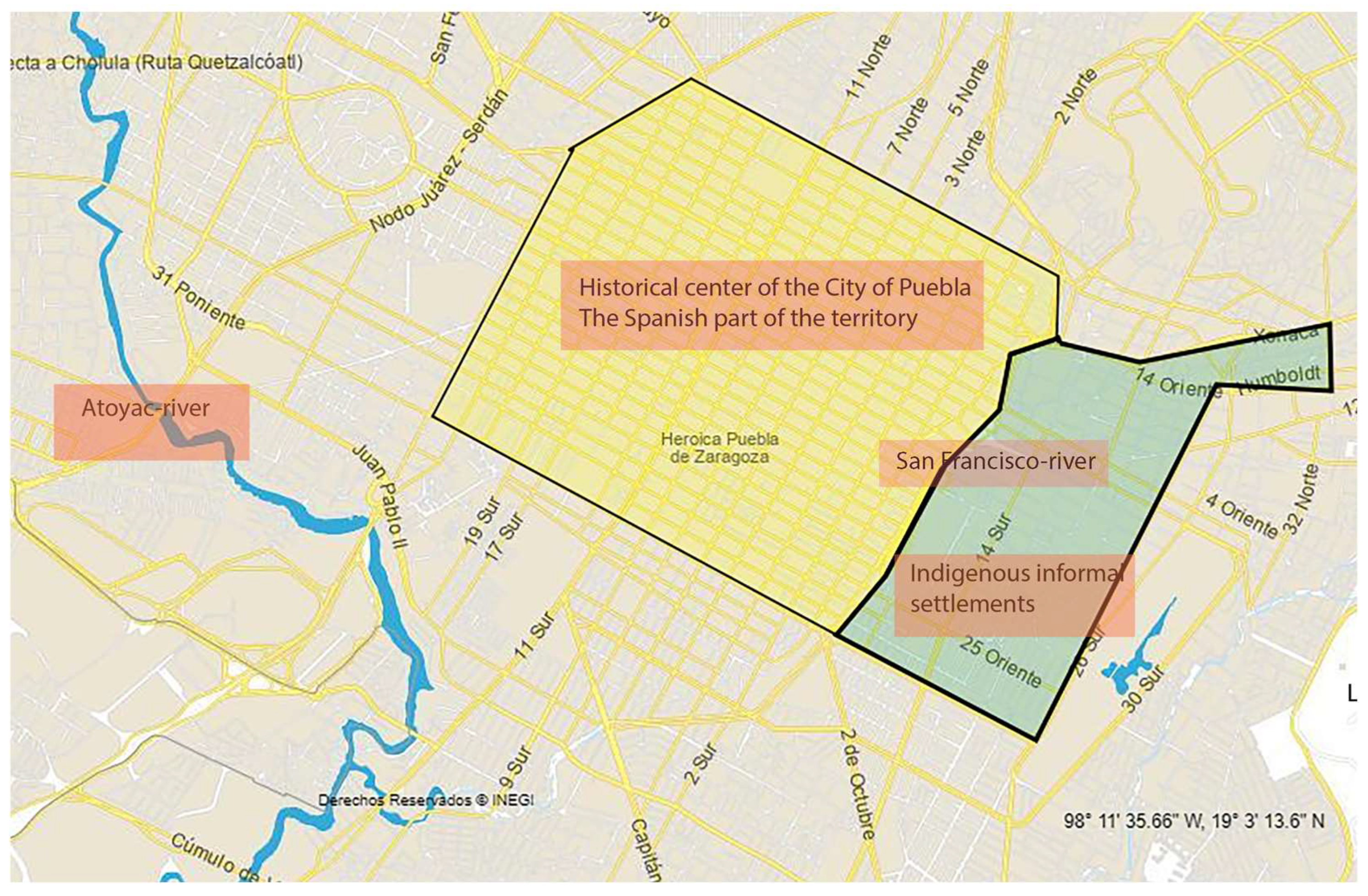
3.1.2. Puebla: Foundation and Development of a Colonial City

Nancy Churchill [12] describes, how shortly afterward Hernando Cortés arrived in what is now Mexico in 1519, the Spanish Colony of New Spain started the construction of its new colonial bastions to guarantee territorial domination. One of the first to be established was the city of Puebla, founded in 1531, halfway between the port of Veracruz and what is now Mexico City, no man’s land on the Eastern side of the ancient city of Cholula. The new city found an ideal site on this high plain crossed by several rivers adequate for agricultural and commercial activities soon converting it to the second-most important city of New Spain.
Loreto López [13] describes, how shortly after the city’s foundation the urban settlement began to grow to have as its Eastern limit the San Francisco river, nurtured by numerous springs and creeks with their origin on the slopes of the nearby mountains. Further away to the West and outside the urban structure another local river, the Atoyac, was used to irrigate the agricultural production of the new settlement. From the very beginning, the two rivers were used for the production of hydraulic energy, needed for the first pre-industrial productive plants, such as mills, tanneries, soap factories, and cotton and wool workshops.
For Vélez Pliego [14], maps and plans of the colonial cities evidence how colonizers discredited the right of the native people to the land and to the hegemonic urban space through systems of ethnic and racial discrimination and control taking advantage of hydrological and topographical conditions of the terrain. These helped to divide the urban territory and to separate the Spanish cities from the Indian settlements that with time were transformed into mestizo and finally urban proletariat districts in the urban peripheries. Thus, as Nancy Churchill [12] describes, the Spanish city was constructed on the Western bank of the San Francisco River, leaving the Eastern bank to the Indigenous people brought to the city as the labor force. As Homi Bhabha [15] has said, the colonial representation of the political and cultural hegemony, and the social truth was translated to the urban form of colonial cities as Puebla (see Figure 4). The colonial idea of the Otherness triggered an ideology of the construction of socio-cultural barriers for different human existences to give protection to the epistemological edge of the West. This characteristic of the fragmentation of urban territories based on socio-ethnic and racial aspects of the population, as we can see further on, has survived until today and is strongly present in the contemporary patterns of urban development characterized by social inclusion and exclusion.

3.1.3. Modernization of a Colonial City and Emergence of the Urban Binomial
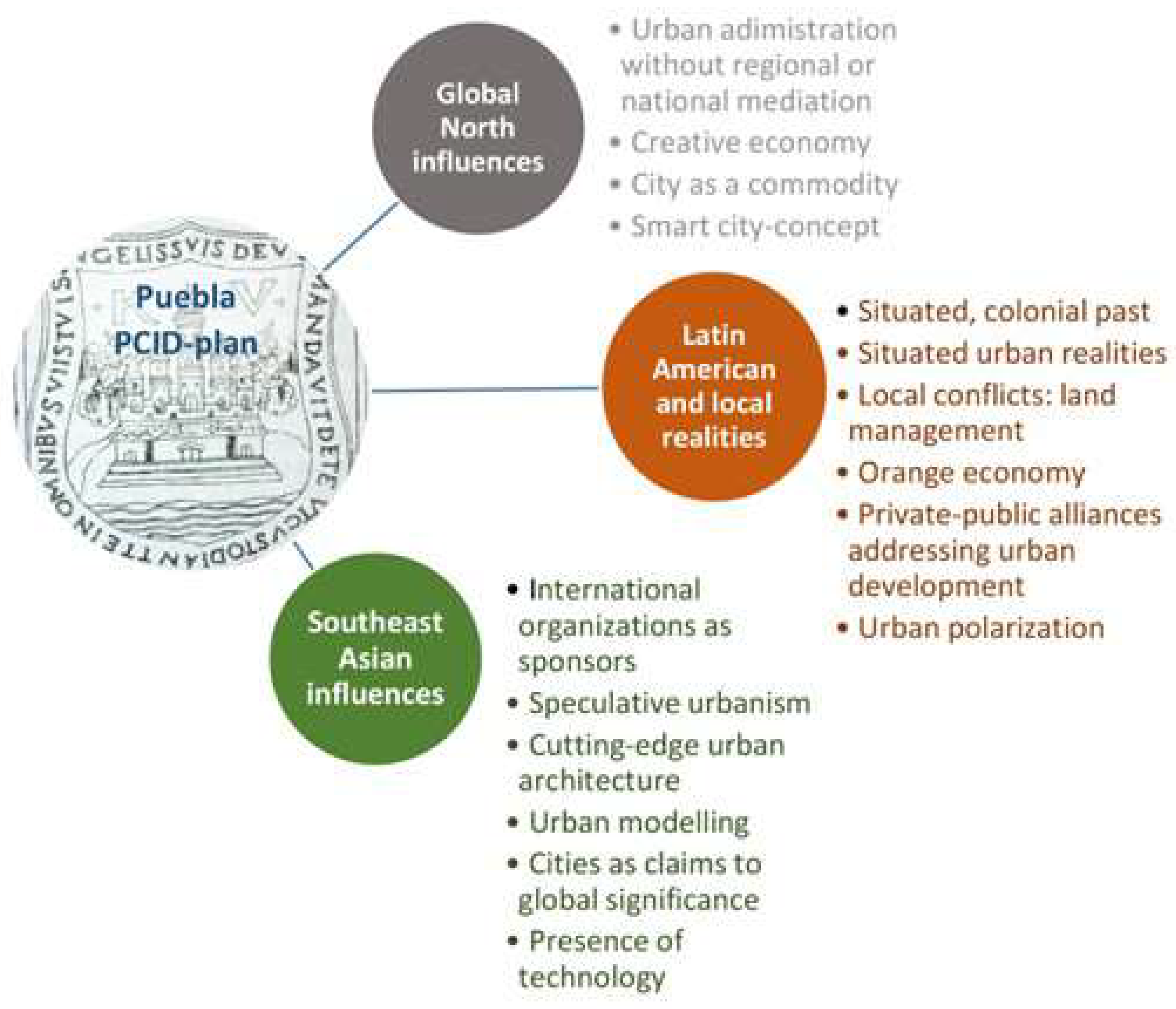
After its foundation, the city structure of Puebla suffered very few changes conserving its colonial limits until the 1940s, as Puebla’s authorities had rejected the modernization and urban renewal, and the development was stagnant until 1993, when the state government of Manuel Bartlett Díaz launched the Angelópolis Plus-plan with the intension to trigger an urban reformation through integral planning and swinging doors wide open to welcome the globalized economy and foreign investment. When the period of his state government ended in 1999, the Angelópolis Plus plan was abandoned [16] until 2011, when the elected governor Rafael Moreno Valle revived this project, now having in mind its potential to insert Puebla as a Latin American node in the networks of the global economy. Contemporary lifestyles, urban security, cultural industries, historical patrimony and memory, smart urban environment, and renovated urban image were key concepts to catapult the city to international knowledge through nominations and certifications. In this framework, the Puebla CID plan [17], influenced by the Orange Economy model [18], promoted it in 2015 as a Smart City and later in the same year as a Creative City in Design by UNESCO [16].
The recovery of the ideas of the Angelópolis Plus plan in 2011 by the Moreno Valle state government gave special importance to the urban territory by the Atoyac river. Going back in time, for the year 1989 the urban growth of Puebla had reached its Eastern bank though it consisted mainly of irregular settlements that the city council years later had to formalize and provide with urban services. Besides them, along the river, popular housing complexes have been constructed by the Institute of the National Housing Fund for Workers (INFONAVIT). Thus, this area maintained its character as a low and middle-income district. On the other hand, the 1993 Angelópolis Plus-plan exposed the economic potential of the Western bank of the Atoyac for the urban expansion of the city of Puebla [19,20], with the ultimate inconvenience that, according to the colonial Royal Certificate and the official municipality limits, it belonged to the neighboring rural municipality of San Andrés Cholula. Puebla’s aspirations to extend its territory beyond the Atoyac river triggered a political controversy and a legal struggle in federal courthouses over the ownership of this potentially lucrative urban land between these two municipalities. Insisting on expanding Puebla beyond the Atoyac river, the Angelópolis Plus plan of the state government promoted extensive expropriations of San Andrés Cholula’s agricultural lands to give space for urban growth. These actions of appropriation were executed from 1993 onwards and especially from 2011 to 2017, as the state government started to carry out an organized transformation of this zone to a ‘New Puebla’ with luxury malls, hotels, entertainment, and cultural centers, universities and residential gated communities connected to extensive and exclusive green belts along the Atoyac-river [21], initiating territorial struggles between San Andrés Cholula’s rural population and state authorities about the right to the land and to the natural resources, though finally having to accept the loss their rural lands.

4. Results

4.1. References from the Global North: Global Economy, Expulsions, and Environmental Crisis

In 2010, Saskia Sassen [22] defined the metropolis as sites in which globalization has found wide opportunities to take root triggering development processes aiming at pinning them up as nodes for the management of global financial flows. The by-product of these processes, as Sassen observed, was urban polarization due to the increment of urban poverty triggered by macro-social tendencies related to cities’ own economic, political, and cultural processes and practices. Harvey [23], on the other hand, observed an especially notable characteristic in these contemporary urban processes: their focus on the development of changes in lifestyles considering them as merchandise transforming the city itself to a consumer product offering conditions for temporal or permanent experiential life in the framework of the creative economy for those who could afford it. The resulting urban polarization caused by the unbalanced distribution of resources can then be seen in the urban image and structure through the emergence of gated communities, compact urban centers with spectacular skyscrapers and public spaces, and, on the other hand, misery belts in the urban peripheries as ‘micro-states’ of prosperity and poverty.
In her 2014 book Expulsions. Brutality and Complexity in the Global Economy [24], Sassen tackles the issue of ‘logics of expulsion’, mentioning how the last two decades have evidenced territorial expulsions of people due to the economic dynamics of our time, fracturing cities in a before unseen ways, making visible growing tendencies of inequality as, according to Sassen, a pathology of contemporary global capitalism. With this, she is paying attention to the augmented social fragmentation that is appearing as a growing urban and socio-territorial characteristic even in the contemporary cities of the Global North. Furthermore, she declares how advanced political economies have created realities in which financial, political, and legal complexities tend to produce elementary brutalities [24]; “[t]he globalization of capital and the sharp rise in technical capabilities have produced major scaling effects” [24] p. 3. Sassen points out the contemporary logic of speculation-driven finance to seek hyper-profits frequently triggering damaging consequences to people, places, and the environment. She explains quite interestingly how the territorially expelled, now living at long distances from the new and complex invasive and dominating power systems of persons, networks, and technology occupying renovated urban cores, still are indispensable for the social infrastructure of power of global cities [24]. This is especially true in a country such as Mexico, where the new urban elites, strictly wanting to live separated from the lower-class population, also need them to give essential maintenance, security, and housekeeping services to their homes, offices, and gated communities.
Finally, Sassen [24] draws our attention to the environmental damage caused by globalization and the commodification of water and land mentioning how the deterioration of the quality of land, water, and air has affected the urban population, but especially the marginalized urban populations triggering human displacements worldwide. Though, Sassen is not analyzing environmental problems from a detailed urban scope but concentrates her observations on the global scale of economics and politics. Related to this, the Latin American theorist Néstor García Canclini [25] has made considerations of what globalization has meant on the regional scale. He explains how at the beginning of the 1990s the tendency observable in Latin America was that of countries reordering their national economies to attract investments and to increase their competitiveness in the global market. Thus, globalization policies were accepted because they promised development and prosperity the people and governments of the developing countries badly needed, with the notion that not all groups were permitted to participate in the globalization processes. Thus, this differentiation triggered the emergence of inequality between those connected to global networks and those separated from them, reflecting at this point the inherited colonial difference, as can be further seen in the case of Puebla-San Andrés Cholula-urban binomial’s socio-territorial development.

4.2. References from the Global South: Local Scope of the Postcolonial Southeast Asia

4.2.1. Cities and National Ambitions

According to Ong [1], the first decades of the 21st century meant the expansion of the global city idea to the Asian continent, revealing national aspirations reflected in local public policy focused on the ‘worlding’ of big cities. The rise price of the new Asian financial region attracted a great volume of international trading away from traditional Western financial centers. Added to this, investments in financial technologies incremented the pace and volume of trading and the scale of financial interactions especially in Southeast Asia. As a consequence, the appearance of new global cities in Asia challenged the already established Global North concepts about urban globalization triggering the need to study the phenomenon from the postcolonial and local scope. What Ong observes is that the Asian environmental dynamics of financial reconfiguration emerged from specific assemblages of urban aspirations focused on the desire to create and promote globalized urban hotspots, in which the global was fused with the situated post-colonial realities, giving a totally new dimension and paradigm to what it means to be a global city in the post-colony, on one the hand tightly connected to a capitalist world but on the other, powerful visual icons for the emerging non-Western economic, financial and political powers [1].
In this context, as Aihwa Ong [3] pointed out how “emerging nations exercise their new power by assembling glass and steel towers to project particular visions of the world” (p. 1). Singapore, Shanghai, Seoul, and Hong Kong, as new powerful centers of finance, started transforming their urban landscape and skyline through cutting-edge innovations in urban architecture and design, to expose through their urban image their new role in the global economy reinventing, as Ong mentions, urban norms and paradigms that showcased their position as global cities. Thus, in Asia, cities started to embody nationalist ambitions of wealth, power, and international recognition. They became sites for instantiating their countries’ claims to global significance. As such, their urban codes of city norms and accomplishments were not detachable from their situated politics related to their role as image icons in a global inter-city game of gaining international prestige.
Thus, in terms of strategies for the creation of novelty and speculative urban imaginaries, urban modeling tools used in Asia have spread beyond its borders, to other parts of the post-colony, showcasing national and local ambitions through discursive and material gestures, inspired by non-Western urban image icons. What modeling means here, is the creation of new urban concepts related to sustainability, habitability, or being world-class eagerly followed elsewhere in the post-colony hoping to be able to reproduce or surpass the already existing successful effects [3]. Mexico and its cities have not been exceptions in these ‘worlding of tendencies by adopting Asian recipes of urban modeling. In these terms, the Puebla CID plan [17] and IDB’s Orange Economy document [18] refer to Asian examples, highlighting the importance of urban design and architecture in the construction of an imaginary competitive global city distinguished by its creative, innovative, and productive capacity.

4.2.2. Territorial Order, Land Speculation, and Urban Modeling

Ong [3] points out how Asian neoliberal urban practices have rearticulated and reassembled as material, technological and discursive elements in the processes of remaking the urban territories by new alliances between political and economic actors. What has been notable in these processes, is how they have ignored the urban poor or other groups not fitting to the neoliberal global form, expulsing them from the most profitable urban lands to improvised settlements in the urban outskirts. Ong [3] highlights how the Western theory of globalization does not totally respond to the locally situated ‘worlding’ processes, urban resistances, and socio-territorial patterns of the developing post-colony and their consequences, which should be understood considering the realities emerging from the colonial roots. For Ong, the colonial past plays an important role in the present urban culture and territorial order: “Postcolonial theory is thus as much about how contemporary urban situations have been shaped by colonial legacies of injustice as by contemporary problems of urban underdevelopment” [3] (p. 9).
Ong argued that urban modeling is a political tool to change the social spirit of an urban environment exposing its symbolic values and desirable icons of ‘world-class’ amenities: luxury hotels, shopping malls, entertainment and convention facilities, cultural centers, international enclaves, and airports as urban attributes. Thus, cities aspire to be sites for the expansion of a new middle class offering attractive conditions for working and living. With urban modeling as a political and economic tool, strategies that Goldman [26] calls ‘speculative urbanism’ emerge: the urban land has become the key issue for planners and developers. Goldman mentions how in the East Asian context, the practice of selling land and displacing the original population to favor public and private goods and services has become one of the primary interests of governments with aspirations to re-engineer their cities to be globally competitive. Thus, the speculative government has become the new political rationality in which the primary relationship between the local people and their government is related to landowning.
Goldman [26] describes how in Asia there has been a vigorous promotion of what he calls the ‘urban turn’ in which regulatory changes by states and new investment strategies by private firms have triggered the creation of ambitious master plans to design worlding of urban landscapes. To achieve a successful urban transformation through modeling, local state agencies have privatized many of their public tasks transferring them to an expanding local and transnational elite. In Asia it has been sometimes difficult to find vast open areas to build upon and new land for urban expansion must have been acquired from the villages of the local rural population. Thus, as Goldman denounces, the previous agricultural lands have been transformed into high-value gated communities, world-class hotel complexes, ‘medical tourism’ hospitals, and business centers by developers converting the cheap public and undervalued private or communal lands into real estate skyrocketing their value and triggering so a massive displacement crisis. The ‘urban turn’ observed by Goldman in Asia, has also landed in Latin America. In the case of our urban binomial, the public policy since 1993 and all the regulatory changes related to landowning and urban norms have been decisive in triggering urban and territorial transformations focused on ‘worlding’. Indeed, as in Asia, the ‘speculative urbanism’ executed here, as explained further in this article, has triggered considerable human displacements.

4.2.3. Becoming Global in Latin America?

As mentioned before, the economic development of the Asian countries, the ‘Asian Tigers’, influenced the Orange Economy model [18] for Latin America developed by Felipe Buitrago Restrepo and Ivan Duque Márquez, the model being sponsored by the Inter-American Development Bank (IDB), and based on the concept of the creative economy defined by John Howkins in 2007 [27]. Howkins focused his idea on the economic potential of talent and creativity that could be exploited through creative goods and services in the framework of architecture, arts and design, research, fashion, development of software, etc. Buitrago and Duque highlight the creative economy’s potential to boost the social and economic development in Latin America and the Caribbean recognizing though also the dangers of its implementation: unemployment and migration of the technologically unskilled triggering social instability. On the other hand, it could motivate a socio-economic transformation for many Latin Americans, being able to experience the highest growth in wealth in their history, enjoying disposable income for the first time in their lives to personalize their consumption in which the technology is integrated into the consumption of contents.
In the Orange Economy framework, the focal task of cities is that of attraction, retention, and reproduction of the talented segment of the population through urban development plans of creative cities, based on the idea of an equilibrium between creativity, enjoyment, and environment, understanding this latter as amenities and lifestyle. This creative environment must be provided with high-quality infrastructure (public transportation system, Internet connections, highways, airports, etc.). The last step in the development of a creative city is obtaining global recognition as an internationally identified center of cultural excellence, attracting varied and abundant tourism for its architecture, festivals, museums, history, and nightlife [18]. We can argue that in the context of the socioeconomic realities of Latin America, the creative cities described in the document of Buitrago and Duque would be artificial ‘bubbles’ separated from the conflictive socio-environmental and socio-territorial realities of the region. Thus, as could be expected, the Puebla CID plan inspired by the Orange Economy idea, among other triggers, was from the beginning a potential detonator of territorially situated processes of inclusion and exclusion, reinforced by neoliberal urban public policy.

4.3. Worlding the ‘New Puebla’

4.3.1. Urban Modeling and Creation of a Global Imaginary

For the 2011–2017 Puebla state government, the neoliberal public policy formed the main development framework for driving Puebla as an important Latin American node and benchmark in the global economy. At that point, the state government found federal support for its plans in ProMéxico, founded in 2007 and dissolved in 2019 by the leftist López Obrador federal government. ProMexico was a trust of the Federal Government—sectored into the Ministry of Economy—promoting international trade and investment aiming at consolidating Mexico as an attractive, safe, and competitive destination for foreign investment [28]. Thus, the previously mentioned implied generation of new paradigms for the planning, programming, and execution of a new urban reality based on providing an improved social environment and urban sustainability, distinguished by international recognitions and nominations, such as Smart City and World Capital in Design by the UNESCO, recognizing it as an attractive city to live [17].
To trigger the desired urban development, the 2011–2017 state government implemented aggressive strategies of public and economic policies that opened opportunities for urban developers and architects inspired by the urban modeling that had given an iconic form and skyline to Southeast Asian global cities [29]. The globalizing Puebla had to focus its efforts on structuring its socio-economically fragmented and historically polarized territory to adapt it to the new urban ideals established in the Puebla CID plan, among them creating an adequate global image [17].
The urban transformation of Puebla through the Puebla CID plan [17] was intended to make it a creative city as described in the Orange Economy model [18]. But the most part of its urban territory was not apt for that; the Northern, Eastern, and Southeastern parts of its territory were occupied by low and middle-income populations, people employed in commerce, services, or industry. The most potential areas for the development of the creative city idea were those on the Western and Southwestern sides of the city, mainly beyond the Atoyac River, with the abovementioned inconvenience of not being part of the urban land of the city of Puebla, but that of the municipality of San Andrés Cholula. Despite the legal disputes, the iconic ‘New Puebla’, the Angelópolis district, began its development in this area as the focus point to attract talent and business and to produce creative goods and services. Following the idea of an iconic urban image as that of the Southeast Asian global cities, a great number of residential and office towers with spectacular architecture and modern gated communities were designed, and experiential public spaces were created. With all that, the urban image of Angelópolis followed the ideals of the contemporary visual culture with its contained and aggressive aesthetics [21,29]. Certainly, the new urban structure was converted to an attractive area to live for the new groups of the population moving in from near and far, and with it, the number of habitants in the municipality of San Andrés Cholula in 2020, [20], increased by 53.8% compared with the year 2010 [30]. The new incomers changed the socio-economic profile of Cholula from rural to a conflicting combination of low-income and high-income populations living side by side. The logic behind all the development was that of business focused on the increment of the surplus value and productivity of land, and the real estate developers had the central role in setting the pace for the development in the Angelópolis district [21] incrementing the socio-spatial segregation very much reflecting the inherited colonial discrimination pattern based on, in the case of Cholula territory, creation of urban barriers to separate the Indigenous communities, the Pueblos Originarios, from the new higher middle-class dwellers of the Angelópolis district (See Figure 5 (below): blue—Angelópolis, yellow—Puebla’s poor, irregular settlements, red—Pueblos Originarios communities).
Finally, even the Atoyac River recovered its colonial role as a socio-economical barrier, now separating the irregular settlements on the Eastern side of it, still occupying the land legally belonging to the city of Puebla. As Guevara-Romero and Ramírez-Rosete [31] observe, those living on the Eastern bank perceive their opportunities to connect to the basic urban infrastructure and services as precarious compared with the real estate development on the Western bank, as shown in the aerial view of 2019 of the following Figure 6: above 1. Concentrations of poverty and informal settlements on the Eastern bank; 2. The Lomas de Angelópolis gated communities, 3. The La Vista gated community, 4. The Atoyac River is the border between Cholula (above the river) and the City of Puebla (below the river). Below, from the left to the right: Angelópolis residential towers in construction on the Western bank in 2019; irregular settlements on the Eastern bank of the Atoyac River in 2014; Angelópolis shopping center in 2014).

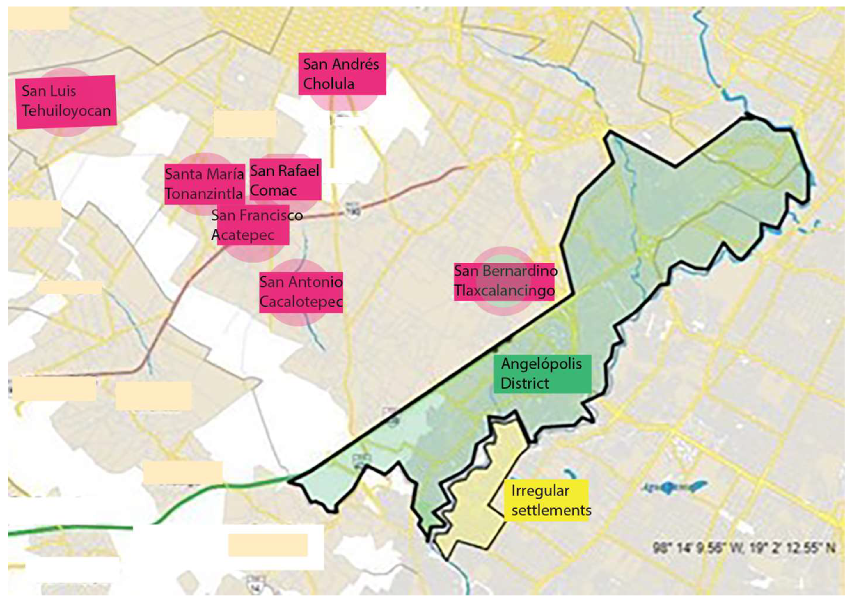
4.3.2. Pueblos Originarios, Neoliberal Land Management, Territorial Disputes, and Socio-Racial Discrimination

The neoliberal urban development of the Angelópolis district has impacted especially the Indigenous population of the municipality of San Andrés Cholula, and its Pueblos Originarios, or First Peoples communities, as descendants of the original Indigenous population of the site. Cholula’s territory has been inhabited for thousands of years, and thus recognized and protected by the Mexican Constitution [33,34,35,36]: it “recognizes Indigenous peoples’ traditional ways of social, cultural, political and economic organization, and decrees their right to manage their habitat and preserve their land (Article 2)” [34] (p. 2), confirming through Article 27 that “laws must protect the integrity of Indigenous lands” [34] (p. 2). What is important here, is not the racial dimension of the sense of the law, as Article 2 of the Mexican Constitution establishes as the primary criteria to determine the indigenous identity, the self-awareness of Indigeneity as the basic criteria for being Pueblo Originario. The distinction thus links a person or a group of people to an Indigenous community acknowledged by the Mexican State, due to cultural, historical, political, linguistic, and other types of connections [34,37]. Also, the international law, through the United Nations Declaration on the Rights of Indigenous Peoples of 2007, in its Article 32, establishes that
States shall consult with indigenous peoples through their own representative institutions to obtain their free prior informed consent prior to the approval of any project affecting their lands or territories and other resources, particularly in connection with the use of mineral, water or other resources.
[38] (p. 12)
The previous reference to the Constitution is especially relevant, as the municipality of San Andrés Cholula and its population has been strongly impacted by the 1990s and 2011–2017 periods of neoliberal metropolitan development as 25% of its territory, until today, has been affected by expropriations and urbanization promoted by an aggressive real estate business and socio-environmental transformations [36]. This is relevant, as the identity of the Pueblos Originarios of Cholula is rooted in their territory, land, and traditional socio-spatial form of organization, the before mentioned altepetl, having a strong connection to their historical territory through a particular socio-spatial and bio-cultural relationship with land [34].
Despite the legal protection of the indigenous territories in San Andrés Cholula, a great number of hectares of rural lands have been converted to urbanized land under economic and political pressure by the state government and the real estate business triggering constant conflicts related to landowning: “San Andrés has been subject to constant conflicts linked to displacement, expropriation, touristic exploitation, social and urban exclusion, and disputes over land rights” [35] (p. 3), threatening the traditional land use [39].

4.4. Key Findings

4.4.1. Global Influences

Conceptually, the Puebla CID-plan adopted the Global North scope of the city as a commodity providing fashionable lifestyles and experiential life as important attractors for talent the local businesses and industry were looking for to boost them internationally [17]. It is important to highlight that urban transformation processes tend to follow the interests of the real estate business, the fact that Mexico constantly creates conflicts about the possession and occupation of land and problems related to the right to the city, with some similarities with the land management problems in many urban areas in Southeast Asia. If the globalization of cities in the Global North has meant an unequal distribution of wealth causing urban polarization, the same phenomenon is present in metropolitan areas as that of the Puebla-San Andrés Cholula-binomial, though the socio-economic distance between the different groups of urban habitants is enormously bigger than in any developed country. Here it is important to pay attention to how the colonial idea of the city as a tool for socio-territorial subordination is still prevailing.
In Southeast Asia, the image of cities has been created to promote each nation’s potential as economic and financial nodes in global networks. In the case of Puebla, ProMexico’s participation inspired by the Orange Economy model of the IDB and the development of the Puebla CID plan [17] focused on achieving international nominations and recognition in technology, culture, and design as the main attractors of international investments, and global actors as the UNESCO were drawn as driving forces for the urban development. What is certainly notable is the adaption of the Southeast Asian model of speculative urbanism and urban modeling to create an urban image as a cutting-edge differentiator concentrated in the Angelópolis district. Thus, it is there where the main pole of global significance of an economic potential was intentioned to emerge highlighting its profile as a smart and creative city and producer of vanguard culture and knowledge.
As mentioned before, the Latin American colonial past is present in Puebla’s current urban realities despite all the influence and impact of the globalization processes. In general, social inclusion and exclusion are more than visible in the city, as well as subtle tools giving perpetuity to this separation, such as the urban connectivity through the public transportation system limiting the accessibility of certain population groups to exclusive lifestyle zones as Angelópolis district. (Figure 7 below describes the influences of the Global North theoretical core, Southeast Asian urban examples, and local, Latin American, and colonial realities in the urban development addressed in the Puebla CID plan).

4.4.2. Urban Planning, Land Use and Management: Social Sustainability, Discrimination, and Population Displacements

What has been observable from the beginning of the creation of the Territorial Reserves in the Cholula territory has been the presence of speculative practices by the real estate business backed up by state and municipal governments that, through expropriations and higher land tenure taxation, have reduced the extension of the rural land, triggering population displacements causing loss of identity and traditions, and finally also, accelerated population growth due to new inhabitants occupying the new habitational developments [36]. The urban planning 2011–2017 in the Angelópolis district, appropriating the previous rural lands of San Andrés Cholula and its Indigenous communities through planning tools, proposed to create a compact city with a dense land use and vertical edification, seeking to ‘modernize’ it, applying urban modeling strategies to create an attractive contemporary urban image and skyline. In terms of land use, land management dynamics did not recognize the limits of the Pueblos Originarios, thus making it easier to connect San Andrés Cholula territories to the urban development of Puebla.
The 2011–2017 land management paved the way for the current clash between the state and municipal authorities, and the Pueblos Originarios, about the right to the land and to the auto-determination, as established in the Constitution. On the other hand, and very importantly, socio-ethnic disputes have emerged in the Angelópolis district, as instead of promoting integration and tolerance between the original population and newcomers, the planning has introduced the idea of a necessity of repelling the different ‘Other’ erecting urban barriers and socio-economic obstacles. The property management systems introduced by the real estate business have isolated the newcomers from the original population through walls and other restrictions, meanwhile the latter feel the first as invaders that have occupied their inherited lands by force. Urban modeling has created ‘urban bubbles’ of artificial realities in the name of modernization, intentionally disconnected from the surrounding urbanities. More grievously, the speculation has skyrocketed the value of the land, as also the land tenure taxation, triggering the expulsion and displacement of the original population without economic resources to cover the costs, putting in danger the socio-territorial sustainability through demographic integration.

4.4.3. Ecological and Environmental Sustainability

The dense urbanization in the Angelópolis district has severely affected the local ecological balance and agriculture especially due to diminishing water reservoirs (See Figure 8, presenting water resources of Central Mexico. Grey-no sufficient water resources; red-water resources available; blue-San Andrés Cholula; Yellow-Puebla). Traditionally, the water supply of Cholula communities has been based on families’ own, particularly wells that now, due to the overexploitation of underground water supplies by new urban developments have left the local communities and their agriculture without sufficient irrigation. Also, since the 2011–2017 planning, no all-covering basic urban services such as potable water or sewer systems [35] were contemplated. For instance, wastewater and solid waste have been a serious problem, as much of them end up in the creeks and rivers of the area, polluting them and the surrounding lands. It would be indispensable to define all the surviving natural areas with special environmental values to be urgently protected to improve the catchment of water to permit the recovery of water resources and to guarantee the continuity of local agricultural activities. On the other hand, local endemic vegetation, today dangerously affected and disappearing due to the intense construction activity and lack of water, has traditionally provided food supplies for the local population that now are getting scarce. Thus, the territorial growth pattern powered in the 2011–2017 period, has put existing ecological thresholds at risk, as original environments have been partially modified by anthropogenic activities. Correspondingly, environmental restoration and preservation would be essential since they contribute to the environmental balance and maintenance of the territory’s ecosystems [36]. The Political Constitution of the United Mexican States [33] declares, that to give order to human settlements and to define adequate provisions, reserves, and use of land, water, and forest, adequate measures should be sought to guarantee the construction of infrastructure, planning, and regulation of the new settlements including their maintenance and improvement, considering their future growth. The Constitution also demands the preservation and restoration of environmental balance and the division of large rural estates, taking into account the collective exploitation and organization of farming cooperatives and the development of small rural properties to stimulate agriculture, livestock farming, forestry, and other economic activities in rural communities. Finally, it prohibits the destruction of natural resources and damages against property to the detriment of society [34].
Finally, in terms of environmental sustainability, Article 104 of the Territorial Planning and Urban Development Law of the state of Puebla [40], establishes that urban densification is permissible when the capacity of water, drainage, electricity, or mobility services is not exceeded, considering the existing urban structure, and improving habitability. This, observing the results of the 2011–2017 urbanization process and its current consequences, has not happened, triggering a process of environmental deterioration that should be urgently attended to.

5. Discussion

We have presented in the introduction of this article five initial statements regarding the urban modeling and its impact on the socio-territorial sustainability in the metropolitan binomial of Puebla-San Andrés Cholula we are going to discuss here. Our first statement declared that the urban development of the area has been influenced by the Global North and the Southeast Asian neoliberal lines of thought, manifesting characteristics of both in its territorial management. Indeed, after having studied the Orange Economy ideas [18], the Puebla CID documents [17], and the 2011–2017 urban development and its consequences, we can find coincidences with Saskia Sassen’s [22] observations about globalization in the Global North and how it has triggered urban processes in which cities have been converted into products through localized or localizable urban image nuanced by globalized image patterns. Also, we can find in Puebla-San Andrés Cholula-binomial what David Harvey has mentioned: contemporary urban processes related to changes in lifestyles converted to commodities just as the cities themselves to products in a world of consumerism, tourism, and cultural industries as generators of experiences to those having the monetary resources to pay for them. Thus, we can see that even in the developed world, the polarization is triggering an unbalanced distribution of resources reflected in the urban image itself and in its spaces, fragmenting cities into parts forming ‘micro-states’ of well-being and those of poverty [23]. In the context of globalization, neoliberal public policy, and ‘urban image construction’, the application of ephemeral and distinctive concepts for cities such as ‘being in trend’ has been used as tools for their promotion as ‘fashionable cities’ triggering real estate developments, as can be seen also in the Puebla-San Andrés Cholula-binomial [41].
On the other hand, and as Aihwa Ong [1] highlights, the 21st century has meant the emergence of new economic powers competing with those of the Global North. In the case of Asia, the continent’s big cities very soon began to reflect the national aspirations and thus were focus points for special ‘worlding’ strategies to be able to compete with the Western global cities. As a consequence, the appearance of new global cities in Asia challenged the established Global North concepts about urban globalization and triggered the need to observe the phenomenon from the postcolonial and local scope. In this sense, the colonial past nuances the present urban culture and territorial order due to legacies of injustice as those of peripheralization of the urban poor through the erection or reinforcement of urban barriers to separate the different and antagonistic urban groups from each other, or through expropriations of the land of the rural population for the urban development triggering human displacements and socio-territorial conflicts related to them [3]. What Ong mentions about ‘redesigning’ the city in the developing world related to highly speculative practices in land management, is also present in the Puebla-San Andrés Cholula urban development.
Secondly, we have presented the phenomenon of the creation of a global urban image, through urban modeling and redesigning of big cities especially in Southeast Asia. As Ong [1] points out, in the context of globalizing ex-colonies of Asia, the urban image of the great cities has been converted to the symbol of the emerging economic and political power in which cutting-edge urban, technological, tectonic, and architectural innovations are transmitting the idea of these nations’ new role as powerful global actors demanding international recognition. In the framework of urban modeling, as Goldman [26] mentions, regulatory changes promoted by city administrations have made possible the new investment strategies and through them, master plans on the hands of private stakeholders to design ‘worlding’ urban landscapes, thus also Angelópolis-district. Here, as in Asian examples, the previous agricultural lands were now transformed into gated communities, private hospitals, malls, and business centers, triggering huge increments in land value. Besides the territorial re-design, the architectural patterns of Singapore, Shanghai, Hong Kong, and others, emerged as iconic examples to follow, emphasizing the attractiveness and efficiency of their compact city model and vertical skyline. During the 2011–2017 period and through the Puebla CID-plan, the Southeast Asian cities were mentioned as examples to follow, as icons of economic success and visibility on the global scale. From 2011 until today, we can clearly observe how the Puebla-San Andrés Cholula development concentrated on the Angelópolis-district has followed the strategies of urban modeling aiming at a world-class city skyline of glass towers and gravity-challenging architectural forms aiming at converting it to an icon for an emerging Latin American global city (See Figure 9 Exemplifying urban modeling in the Angelópolis-district).
Thirdly, we declared that the local colonial history and the socio-racial discrimination have been inherited and transferred to the 21st-century urban territorial management. Going back to the beginning of this article, the decade of the 1990s in Mexico meant a radical change in the public politics related to land management. As Schumacher et al. [42] mention, the 1992 Land Reform liberated the communal lands, ‘ejidos’, that before that year could not be commercialized, but were now available for the real estate business triggering a massive urban sprawl outside urban cores and emergence of vast peri-urban areas. Besides this, in the case of the Puebla-San Andrés Cholula region and Angelópolis-district, the 1993 Angelópolis-plus-plan made possible the vast expropriations of rural lands of the Pueblos Originarios of San Andrés Cholula, to give space to the construction of the ‘New Puebla’. 2011–2017 urban development based on the Puebla CID plan, seeking a global image, and providing an attractive urban environment for a higher middle-class experiential lifestyle, triggered the forced (expropriations) or silenced (high land tenure taxation) displacements of the Indigenous population. On the other hand, the real estate business promoted the idea of separating the urban newcomers from the Pueblos Originarios and other vulnerable groups through urban barriers, such as walls surrounding the new urban developments, surveillance systems controlling the entrances, and urban mobility favoring the use of private cars. Thus, the new higher middle-class population perceives the Indigenous communities and rural communities as threatful ‘Others’ and the latter see the first as illegal invaders. Lastly, colonial socio-racial discrimination has been present also in the planning processes in which, although having a constitutional right to be heard, the opinions of the Indigenous population have been only partially considered [36].
In the fourth place, we have shown how the combination of the mentioned aspects has aggravated the already existing socio-territorial polarization observable in the urban inclusion-exclusion strategies reinforced by the urban planning processes of the 2011–2017 period. The Angelópolis planning in the hands of private stakeholders of real estate business, and the state and municipality administrations supporting them, has triggered confrontations between them and the local Indigenous and rural communities about the right to the land and to the local traditions and culture related to it. The Pueblos Originarios have demanded the valorization of their cultural practices, conservation of their agricultural lands, as well as the traditional landscape, urban image, and character of the public spaces of their villages [36], meanwhile the state and municipality authorities have insisted on the necessity of ‘modernization’ of the Cholula territory through its re-engineering and urban modeling. Territorial controversies nuanced by socio-racial differences and economic and political interests that emerged since the 1990s and reinforced in 2011–2017 have not been resolved despite negotiations carried out.
Lastly, we stated that the territorial processes triggered by the neoliberal public policy of the 2011–2017 period and the corresponding land management strategy have menaced the socio-territorial and environmental balance and quality of life in the metropolitan area of Puebla, resulting today in an unsustainable situation. The municipality authorities and the Indigenous communities point out as the main problems related to the socio-territorial and environmental sustainability the following: chaotic urban development, real estate business speculation, overexploitation of the territory and its resources, loss of agricultural land, loss of identity, customs, and habits, and accelerated demographic growth and displacement of original habitants [36]. Regarding socio-territorial sustainability, the planning strategies should be focused on population integration and not socio-territorial segregation, as until now.
Meanwhile, Puebla’s population has decreased from 2010 to 2020, from 1,834,936 to 1,724,831 habitants, and the population of the municipality of San Andrés Cholula has increased from 2010 to 2020 with 53.8%, meaning this from 115,976 inhabitants to 160,069 inhabitants [43] mainly due to new people moving into the locality from Puebla and other federal states, demanding for housing [36]. The accelerated demographic growth has affected, to begin with, the underground water supplies that for years have been overexploited, causing problems in the local agriculture and also a lack of water all over the urban territory. Augmented paved and constructed surfaces of the urban territory have been for long affecting aquifer recharge areas aggravating the water problem, and elevating temperatures in the locality. Finally, the new urban development requires amplified mobility systems, now proposed as wider streets and highways, augmenting the level of noise and air pollution [36]. Thus, thinking of urban densification and compact city model through the application of urban modeling seems not to provide sustainable solutions to the problems initiated in the 1990s and intensified in 2011–2017.

6. Conclusions

The National Council for Assessment of the Policy for Social Development, CONEVAL [44], reported that in 2020, in the city of Puebla 39.9% of its population lived in poverty, meanwhile in 2020 the percentage had grown to 41.4%. In the case of San Andrés Cholula, the same numbers were 68.3% (2010) and 49.71% (2020). Thus, public policy and public-private initiatives intended to trigger a new, sustainable urban economy seemed not to have given a solution to the basic, urban socio-economic problems in the state capital meanwhile San Andrés Cholula’s percentages may be quite deceptive, as the decreasing numbers of the urban poor may be supposed to be due to the incoming wealthy, higher middle-class population occupying the new attractive gated communities and fashionable department towers. Indeed, the 2020 INEGI census shows, how the demographic growth in San Andrés Cholula has been that of 4.5% per year due to the new population moving in. As a consequence, the urban binomial of Puebla-San Andrés Cholula is today facing the danger of socio-territorial fracturing, making it socially unstable and unsustainable, added to the aggravated environmental problems related to water, air pollution, the disappearance of originally local vegetation and incrementing erosion of the soil that menaces its quality of habitability.

6.1. Suggestions for Public Policy

Though both the municipality and state authorities as the local rural population identify the same basic problems regarding the urban development of the Puebla-San Andrés Cholula-urban binomial, the approach they give to resolving them is contrasting. To face the challenge of solving these problems, it would be indispensable to create functional mechanisms of dialogue and negotiation to avoid confrontations between different interest groups and their stakeholders. The public policy and the corresponding urban planning should take into consideration, (1) not to conceptualize the city as a commodity and provider of lifestyles, nor carry out the urban and territorial transformation based on urban modeling, as has been happening since 1990s in the Angelópolis.district, (2) to treat the current needs and desired futures of all the occupants of the Puebla-San Andrés Cholula-urban binomial in a balanced way, taking into consideration the rural communities, habitants of the consolidated urban areas, but also the recent newcomers already established on the Western bank of the Atoyac-river, despite racial, social, cultural or economic differences, and respecting their constitutional rights, detached from the inherited colonial thinking of socio-racial differentiation, through particular site-tailored development strategies adapted to local realities, (3) to give an organic delimitation for the rural communities’ and Pueblos Originarios’ territory, recognizing their natural dynamics of growth, through inclusive population consultation mechanisms and co-creation workshops, (4) to assure that the mentioned delimitations provide adequate zones for urban transition, not barriers, between the traditional land uses and new urban developments, (5) to control de accelerated urban growth caused by the uncontrolled real estate business through strategic public policy and planning tools, accompanied by effective mechanisms of urban and environmental monitoring carried out by independent experts, and (6) to carry out detailed environmental studies of the complete Puebla metropolitan area and extended to the neighboring state of Tlaxcala, as the basis for a regional environmental public policy and integral sustainable urban and community planning, to link the macro-scale urban development to environmental problematics and existing supplies of natural resources in the Puebla-Tlaxcala valley.

6.2. Limitations and Future Studies

The ultimate purpose of the studies and research project described herein is to provide a multi-dimensional analysis of the development of the territorial situation of the Puebla-San Andrés Cholula-urban binomial, and of its current and potential future consequences, to elaborate analyzed data as supporting information for urban planning of the municipality of San Andrés Cholula. These studies, now focused on and limited to the binomial’s territory, should be amplified to consider all of the Puebla metropolitan area, as mentioned above, as many of the issues highlighted here, such as environmental questions and mobility network, extend beyond its limits to other municipalities and even to the territory of the neighboring federal state of Tlaxcala. The potential limitation to achieving functional, long-term sustainable planning and public policy through collaboration and bottom-up strategies between municipality, state and federal government, and local stakeholders and communities, is the disposition to a multi-level collaboration under the considerable political and economic pressures exercised by different interest groups.

Funding

2014–2017: the Mexican National Council for Science and Technology, CONACYT, funding number 247777, for “Proyectos de Desarrollo Científico para Atender Problemas Nacionales” (“Scientific Development Projects to Address National Problems”). Since 2017, the research has had no external funding.

Data Availability Statement

No new data were created in this study. Data sharing is not applicable to this article.

Acknowledgments

Special thanks to the students Karla Sofía Soto Sandoval and Edna Alejandra Romero Romero, of the Department of Architecture, Universidad de las Américas Puebla (UDLAP) for their collaboration in this project, as well as to the Janina C. Carrera and the Xavier Carrera for their photos.

Conflicts of Interest

The author declares no conflict of interest.

References

  1. Ong, A.H. Powers of sovereignty: State, people, wealth, life. Focaal 2012, 64, 24–35. Available online: http://citeseerx.ist.psu.edu/viewdoc/download?doi=10.1.1.1076.8435&rep=rep1&type=pdf (accessed on 7 October 2023). [CrossRef]
  2. Mouton, M.; Shatkin, G. Strategizing the for-profit city: The state, developers, and urban production in Mega Manila. Environ. Plan. A Econ. Space 2020, 52, 403–422. Available online: https://journals.sagepub.com/doi/pdf/10.1177/0308518X19840365?casa_token=qUIUqAYABkMAAAAA:9xqHCghYVQmFnwaAUN_2mWgwnoeK1yPwKLTtwjFc2NgdQwl0LqATw2EjaHTxdYRX1q_V41TtILCD4cE (accessed on 7 October 2023). [CrossRef]
  3. Ong, A.H. Introduction: Worlding cities, or the art of being global. In Worlding Cities: Asian Experiments and the Art of Being Global; Roy, A., Ong, A.H., Eds.; Blackwell Publishing Ltd.: London, UK, 2011; pp. 1–26. [Google Scholar]
  4. Hart, G. Relational comparison revisited: Marxist postcolonial geographies in practice. Progress in Human Geography 2018, 42, 371–394. Available online: https://journals.sagepub.com/doi/abs/10.1177/0309132516681388. (accessed on 17 November 2023). [CrossRef]
  5. Shatkin, G. Planning to forget: Informal settlements as ‘forgotten places’ in globalising Metro Manila. Urban Stud. 2004, 41, 2469–2484. Available online: https://journals.sagepub.com/doi/pdf/10.1080/00420980412331297636?casa_token=qEUTrRsrT8AAAAAA:XhQKvO6Ody7joUpAwsn7lq4XsY4Bu0zZZzoN29npLJwmDzCsq8Tp34Fj7b4HfEw89HqtSJ7ruIeWwdk (accessed on 7 October 2023). [CrossRef]
  6. Instituto Nacional de Estadística y Geografía, INEGI. Síntesis de Resultados. Zona Metropolitana de Puebla-Tlaxcala. XII Censo General de Población y Vivienda. 2000. Available online: http://internet.contenidos.inegi.org.mx/contenidos/productos/prod_serv/contenidos/espanol/bvinegi/productos/historicos/2104/702825496609/702825496609_1.pdf (accessed on 7 October 2023).
  7. Instituto Nacional de Estadística y Geografía, INEGI, Mapa digital de México. 2023. Available online: http://gaia.inegi.org.mx/mdm6/?v=bGF0OjE5LjA2NDEwLGxvbjotOTguNzYzNjEsejozLGw6YzExMXNlcnZpY2lvcw== (accessed on 18 November 2023).
  8. Ashwell, A. Cholula: Su herencia en una red de agujeros. Elem. Cienc. Cult. 2004, 11, 3–11. Available online: https://elementos.buap.mx/directus/storage/uploads/00000002632.pdf (accessed on 7 October 2023).
  9. Schumacher, M.; Kurjenoja, A.K. La figuración del paisaje de Cholula a través de la mirada de Alexander von Humboldt: Reflexiones sobre su transformación territorial y socio-cultural. Tekopora Lat. Am. J. Environ. Humanit. Territ. Stud. 2021, 3, 139–166. [Google Scholar] [CrossRef]
  10. Reyes García, C. Altepetl: Ciudad Indígena; Cholula en el Siglo XVI; UNAM: Mexico City, Mexico, 1976. [Google Scholar]
  11. Bonfil Batalla, G. Cholula: La Ciudad Sagrada en la era Industrial; UNAM: Mexico City, Mexico, 1973. [Google Scholar]
  12. Churchill, N.E. Erasing Popular History: State Discourse of Cultural Patrimony in Puebla, Mexico. In Proceedings of the XXII International Congress of the Latin American Studies, Miami, FL, USA, 16–18 March 2000; pp. 1–10. Available online: https://citeseerx.ist.psu.edu/viewdoc/download?doi=10.1.1.552.5857&rep=rep1&type=pdf (accessed on 7 October 2023).
  13. Loreto López, R. El microanálisis ambiental de una ciudad novohispana. Puebla de los Ángeles, 1777–1835. Hist. Mex. 2008, 57, 721–774. Available online: https://www.jstor.org/stable/25139804 (accessed on 7 October 2023).
  14. Vélez Pliego, F. Puebla de Zaragoza, Antigua Ciudad de los Ángeles, Patrimonio Cultural de la Humanidad. Rev. Soc. Ciudad. Territ. 2011, 1, 1–47. Available online: https://issuu.com/ablmartilu/docs/pueblafvp (accessed on 7 October 2023).
  15. Bhabha, H. Location of Culture; Routledge: London, UK; New York, NY, USA, 2004. [Google Scholar]
  16. Kurjenoja, A.K.; Ismael, M.E. ¿Puebla, ciudad creativa ó inteligente? In Ciudad, Capital y Cultura; Hernández, A., Kurjenoja, A., Ismael, A.K., Comp, M.A., Eds.; Editorial Itaca: Mexico City, Mexico, 2018; pp. 21–36. [Google Scholar]
  17. ProMéxico. Mapa de Ruta. Puebla Capital de Innovación y Diseño; ProMéxico: Mexico City, Mexico, 2015. [Google Scholar]
  18. Buitrago Restrepo, F.; Duque Márquez, I. Economía Naranja; Inter-American Development Bank IDB: Washington, DC, USA, 2013; Available online: https://books.google.com.mx/books/about/La_econom%C3%ADa_naranja.html?id=I9N2DwAAQBAJ&printsec=frontcover&source=kp_read_button&hl=es-419&redir_esc=y#v=onepage&q&f=false (accessed on 7 October 2023).
  19. Kurjenoja, A.K. Interview in person with a Local Urbanist. Personal communication, 2016. [Google Scholar]
  20. de Puebla, G.E. Programa Regional de Ordenamiento Territorial Angelópolis; Puebla: Mexico City, Mexico, 1993. [Google Scholar]
  21. Kurjenoja, A.K. Economía creativa y cultura en la transformación desarrollo de dos ciudades mexicanas: Puebla y Tijuana. In Globalópolis (Provisional Name of the Book); Marchand, M., Morales, I.M., Meza, E., Eds.; Editorial Porrúa: Mexico City, Mexico, 2023; in press. [Google Scholar]
  22. Sassen, S. Territorio, Autoridad y Derechos de los Ensamblajes Medievales a los Ensamblajes Globales; Katz: Madrid, Spain, 2010. [Google Scholar]
  23. Harvey, D. Rebel Cities. From the Right to the City to the Urban Revolution; Verso: London, UK; New York, NY, USA, 2012. [Google Scholar]
  24. Sassen, S. Expulsions. Brutality and Complexity in the Global Economy; The Belknap Press of Harvard University Press: Cambridge, MA, USA; London, UK, 2014. [Google Scholar]
  25. García Canclini, N. Imagined Globalization; Duke University Press: Durham, NC, USA, 2014. [Google Scholar]
  26. Goldman, M. Speculating on the next world city. In Worlding Cities: Asian Experiments and the Art of Being Global; Roy, A., Ong, A.H., Eds.; Blackwell Publishing Ltd.: London, UK, 2011; pp. 1–26. [Google Scholar]
  27. Howkins, J. Creative Economy; Penguin Books: London, UK, 2007. [Google Scholar]
  28. ProMéxico. Wikipedia. Available online: https://es.wikipedia.org/wiki/ProM%C3%A9xico (accessed on 7 October 2023).
  29. Kurjenoja, A.K. Interview in person with the Architect of PCID Public Spaces. Personal communication, 2016. [Google Scholar]
  30. DataMéxico. San Andrés Cholula; DataMéxico: Municipio de Puebla, Mexico, 2020. [Google Scholar]
  31. Guevara-Romero, M.L.; Ramírez Rosete, N.L. Condiciones de movilidad en colonias marginadas. Unidad territorial Atlixcáyotl, Puebla. Bitácora Urbano Territ. 2019, 29, 31–38. [Google Scholar] [CrossRef]
  32. Google Maps. Available online: https://www.google.com.mx/maps/@19.0753479,-98.3221855,13z?entry=ttu (accessed on 18 November 2023).
  33. Honorable Congreso de la Unión. Constitución Política de los Estados Unidos Mexicanos; 25 Legislatura Cámara de Diputados: Mexico City, Mexico, 1992. [Google Scholar]
  34. Schumacher, M.; Guizar Villalvazo, M.; Kurjenoja, A.K.; Durán-Díaz, P. The Writ of Amparo and Indigenous Consultation as Instruments to Enforce Inclusive Land Management in San Andrés Cholula, Mexico. Land 2023, 12, 9. [Google Scholar] [CrossRef]
  35. Gutiérrez Juárez, E.G.; Kurjenoja, A.K.; Schumacher, M.; Guizar Villalvazo, M.; Gonzalez Meza, E.; Durán-Díaz, P. Neoliberal Urban Development vs. Rural Communities: Land Management Challenges in San Andrés Cholula, Mexico. Land 2022, 11, 1058. [Google Scholar] [CrossRef]
  36. InLAB. Territorio and Urban Artifact Research Group. Interview in person with Cholultecas Unidos en Resistencia, CHUR. Personal communication, 2023. [Google Scholar]
  37. Tetra Tech. Effective Engagement with Indigenous Peoples: USAID Democracy, Human Rights, and Governance Sector Guidance Document. United States Agency for International Development. 2020. Available online: https://www.climatelinks.org/sites/default/files/asset/document/2020_USAID_Effective-Engagement-with-Indigenous-Peoples-USAID-Sustainable-Landscapes-Sector-Guidance-Document.pdf (accessed on 7 October 2023).
  38. United Nations. United Nations Declaration on the Rights of Indigenous Peoples. 2007. Available online: https://www.un.org/development/desa/indigenouspeoples/declaration-on-the-rights-of-indigenous-peoples.html (accessed on 15 December 2022).
  39. United Nations and General Assembly. Universal Declaration of Human Rights; United Nations: Paris, France, 1948. Available online: https://www.un.org/en/about-us/universal-declaration-of-human-rights2 (accessed on 7 October 2023).
  40. Ley de Ordenamiento Territorial y Desarrollo Urbano del estado de Puebla. 2017. Available online: https://www.congresopuebla.gob.mx/index.php?option=com_docman&task=doc_download&gid=12924&Itemid= (accessed on 7 October 2023).
  41. Anderson, N. Sociología de la Comunidad Urbana. Una Perspectiva Mundial; Fondo de Cultura Económica: San Diego, CA, USA, 1993. [Google Scholar]
  42. Schumacher, M.; Durán-Díaz, P.; Kurjenoja, A.K.; Gutiérrez-Juárez, E.; González-Rivas, D.A. Evolution and Collapse of Ejidos in Mexico—To What Extent Is Communal Land Used for Urban Development? Land 2019, 8, 146. [Google Scholar] [CrossRef]
  43. Instituto Nacional de Estadística y Geografía, INEGI. Panorama Sociodemográfico de Puebla. Censo de Población y Vivienda 2020; INEGI: Aguascalientes, Mexico, 2021.
  44. El Consejo Nacional de Evaluacion de la Politica de Desarrollo Social, CONEVAL. Estadísticas de Pobreza en Puebla. Available online: https://www.coneval.org.mx/coordinacion/entidades/Puebla/Paginas/principal.aspx. (accessed on 7 October 2023).
Figure 1. Research project workflow chart elaborated by Kurjenoja. (2023).
Land 12 02081 g001
Figure 2. Elaborated by Kurjenoja from the map of the Instituto Nacional de Estadística y Geografía, INEGI, Mapa digital de México, 2023 [7]. (2023).
Land 12 02081 g002
Figure 3. The Great Pyramid of Cholula. Photo taken by Carrera, C. (2023).
Land 12 02081 g003
Figure 4. Historical center of Puebla. Elaborated by Kurjenoja from the map of the Instituto Nacional de Estadística y Geografía, INEGI, Mapa digital de México, 2023 [7]. (2023).
Land 12 02081 g004
Figure 5. Development of the Atoyac river area. Elaborated by Kurjenoja from the map of the Instituto Nacional de Estadística y Geografía, INEGI, Mapa digital de México, 2023 [7]. (2023).
Land 12 02081 g005
Figure 6. (Above) Elaborated by Soto Sandoval (2019) from Google Maps [32]. (Below) Photos taken by Romero Romero (2014).
Land 12 02081 g006
Figure 7. Diagram elaborated by Kurjenoja. (2021).
Land 12 02081 g007
Figure 8. Water resources, central Mexico. Elaborated by Kurjenoja from the map of the Instituto Nacional de Estadística y Geografía, INEGI, Mapa digital de México, 2023 [7]. (2023).
Land 12 02081 g008
Figure 9. Photo taken by Carrera. X. (2023).
Land 12 02081 g009
Disclaimer/Publisher’s Note: The statements, opinions and data contained in all publications are solely those of the individual author(s) and contributor(s) and not of MDPI and/or the editor(s). MDPI and/or the editor(s) disclaim responsibility for any injury to people or property resulting from any ideas, methods, instructions or products referred to in the content.

