
Research on CLUFS and Its Application in Rapid Prediction of the Impact of Regulating Services Value in Construction Projects


Abstract
:1. Introduction
2. Methods
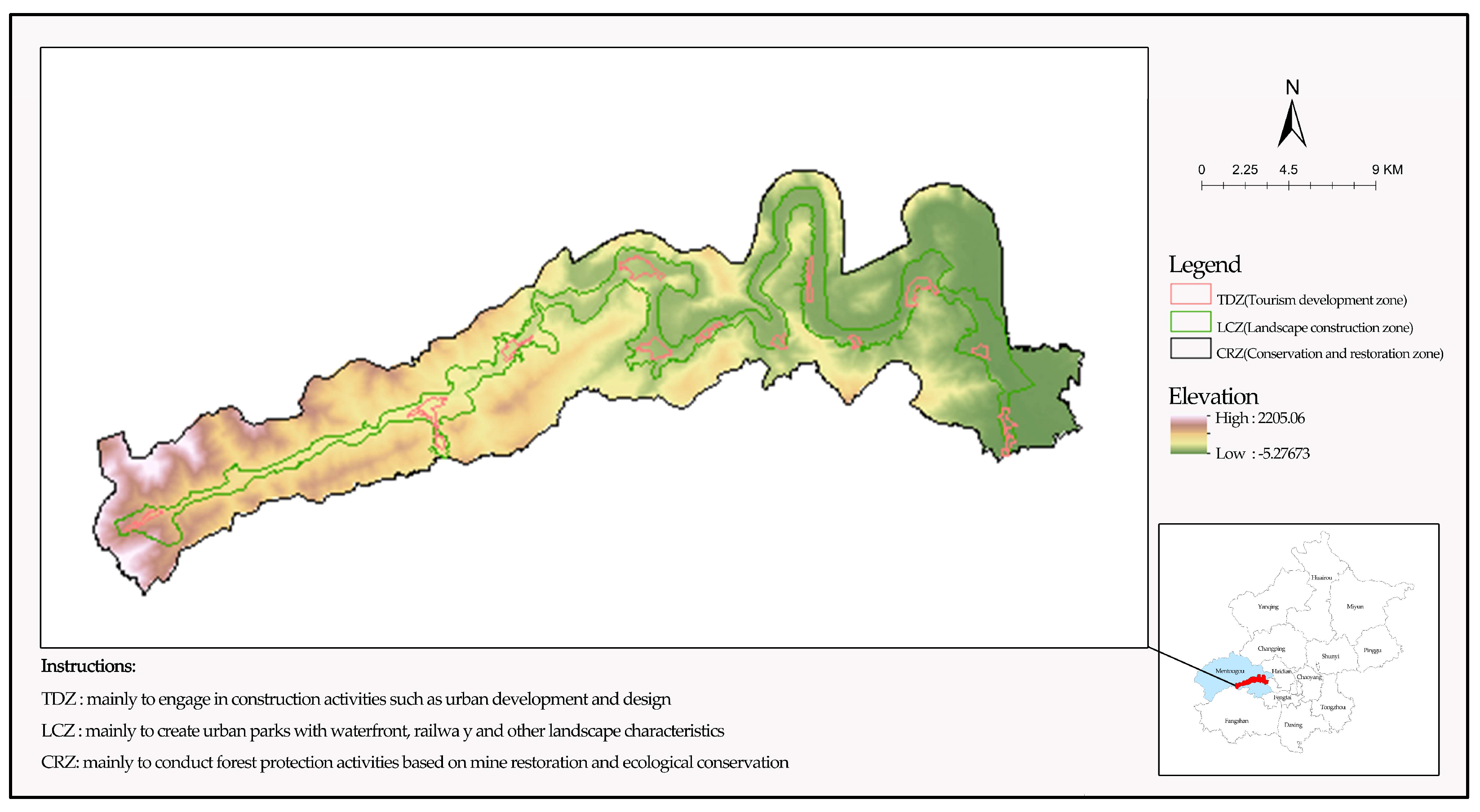
2.1. Study Area
2.2. Data Source
- 1.
- GEP accounting results of Beijing and its Mentougou District in 2020:
- 2.
- Intelligent Urban Ecosystem Management System (IUEMS):
- 3.
- Conceptual Planning of Western Beijing’s One Line Four Mines and Comprehensive Implementation Plan of Wangping Mine planning in Wangping Town, Mentougou District, Beijing:
2.3. Analytical Tool
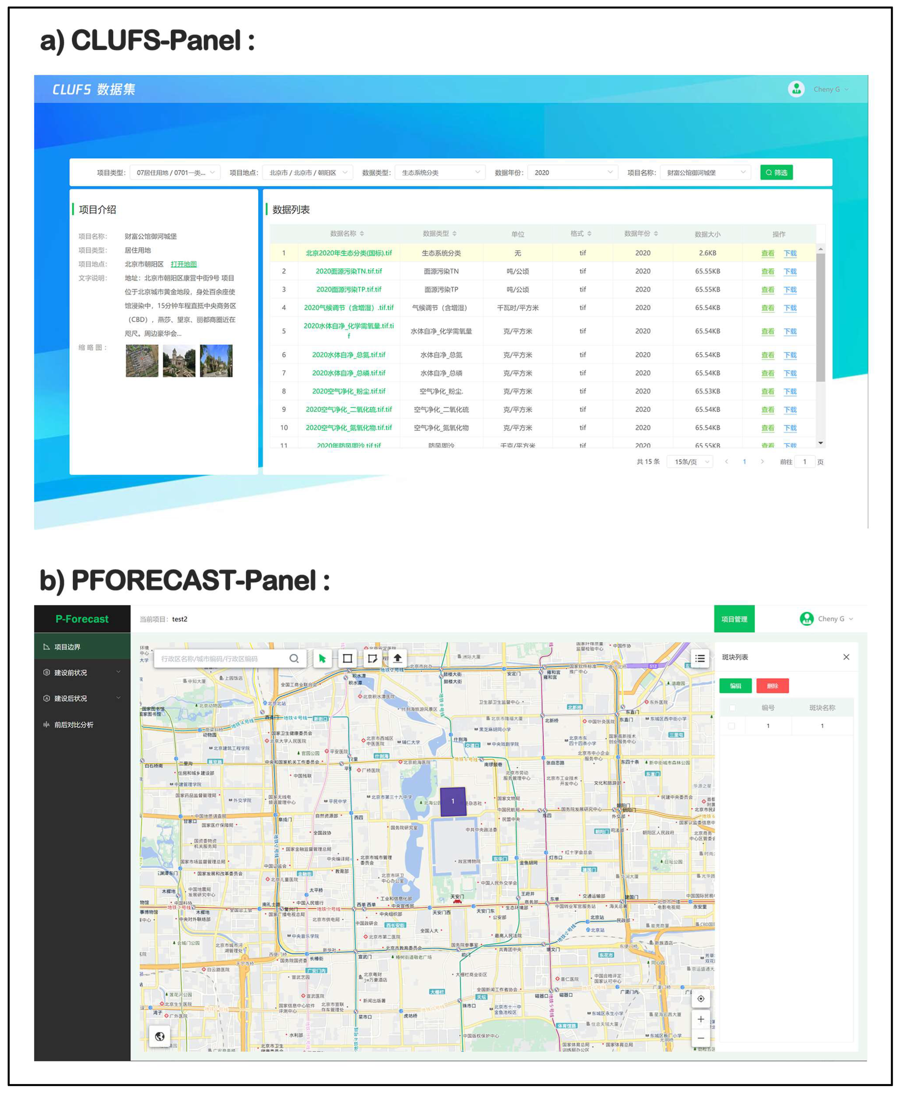
2.4. Building China Land Use Feature Data Set
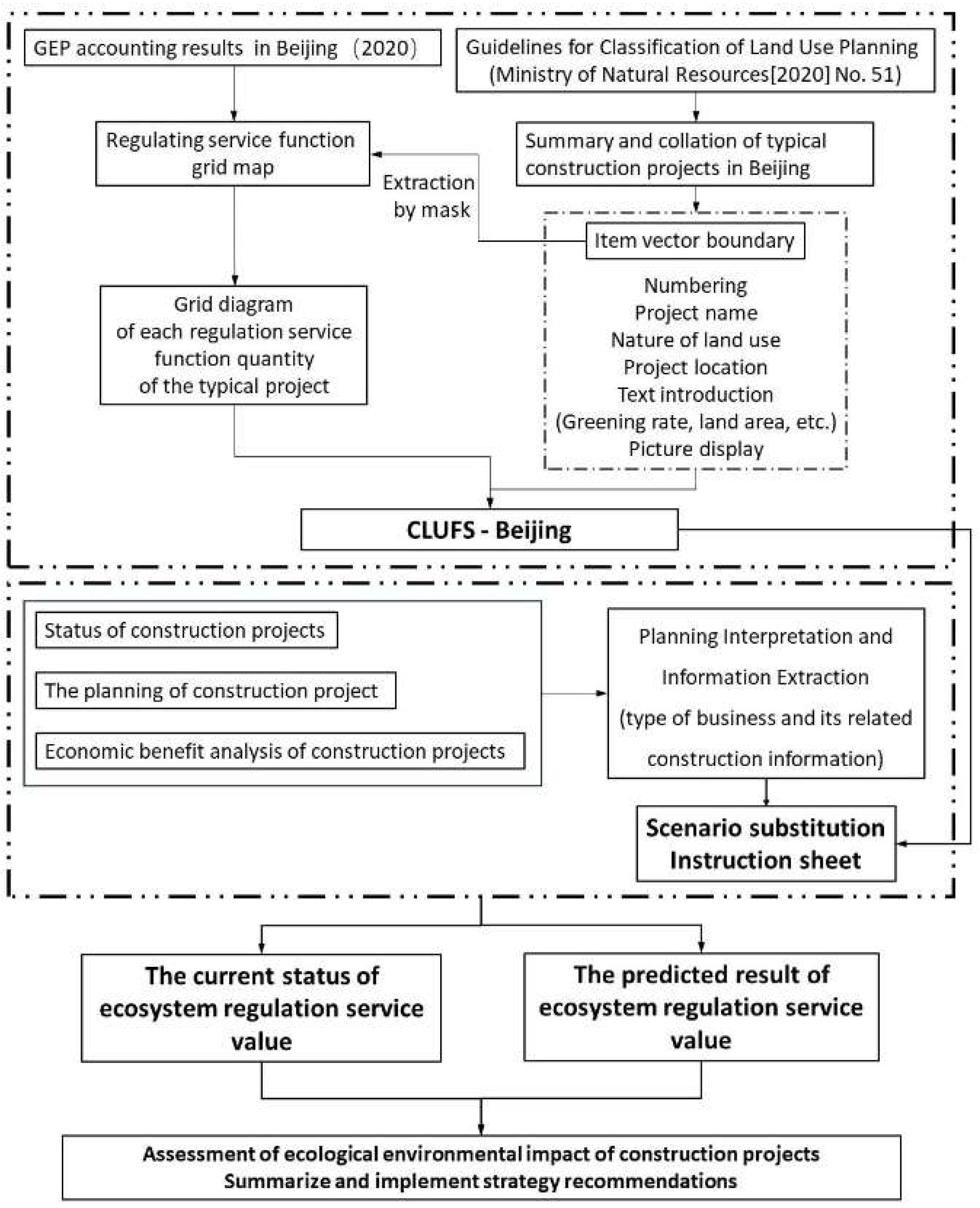
2.5. Technical Route of Ecological Regulation Services Impact Prediction for Construction Projects
3. Results
3.1. Spatial Division and Situational Substitution Results
3.2. Prediction of Influence of ERV in the TDZ
3.3. Prediction of Influence of ERV in the LCZ
3.4. Prediction of Influence of ERV in the CRZ
3.5. Summary
4. Discussion
4.1. Reasons for the Impact of the Project on the Regulation Services
4.2. Recommendations to Achieve Expected Regulation Services Improvements
4.3. Research Limitations and Prospects
5. Conclusions
Author Contributions
Funding
Data Availability Statement
Acknowledgments
Conflicts of Interest
References
- Daily, G.C. Nature’s Services: Societal Dependence on Natural Ecosystems; Island Press: Washington, DC, USA, 1997. [Google Scholar]
- Ouyang, Z.; Cui, S.; Zheng, H. Challenges and countermeasures of ecological security in China. Sci. Soc. 2015, 5, 20–30. [Google Scholar]
- Ouyang, Z.; Wang, R.; Zhao, J. Ecosystem service function and its eco-economic value evaluation. Chin. J. Appl. Ecol. 1999, 10, 635–640. [Google Scholar]
- Wu, N.; Liu, A.; Wang, Y.; Li, L.; Chao, L.; Liu, G. An Assessment Framework for Grassland Ecosystem Health with Consideration of Natural Succession: A Case Study in Bayinxile, China. Sustainability 2019, 11, 1096. [Google Scholar] [CrossRef]
- Ye, Y.; Liu, L. Study on the evaluation index system of provincial ecological environment quality in China. Res. Environ. Sci. 2000, 13, 4. [Google Scholar]
- Ma, J.; Niu, A.; Chen, Z. Evaluation of Natural Ecological Environment in Guangzhou City Based on Remote Sensing Technology and Comprehensive Index Method. J. Landsc. Res. 2016, 8, 79–82. [Google Scholar]
- Zhu, L. Ecological Environment Quality Evaluation of Yangzhou City Based on Principal Component Analysis. Master’s Thesis, Yangzhou University, Yangzhou, China, May 2013. [Google Scholar]
- Zhang, H.; Song, J.; Li, M.; Han, W. Ecological environment quality evaluation and genetic analysis of Qilian Mountain National Park based on GEE. Chin. J. Ecol. 2021, 40, 1883–1894. [Google Scholar]
- Ma, H.; Shi, L. Assessment of eco-environmental quality of Western Taiwan Straits Economic zone. Env. Monit. Assess. 2016, 188, 311. [Google Scholar] [CrossRef] [PubMed]
- Zhao, H.; Jia, L.; Yi, Z. Monitoring of land use and Ecological Environment Change in Tongzhou District, Beijing Based on Multisource Remote Sensing Data investigate. Geogr. Geo-Inf. Sci. 2019, 35, 38–43. [Google Scholar]
- Costanza, R.; d’Arge, R.; de Groot, R.; Farber, S.; Grasso, M.; Hannon, B.; Limburg, K.; Naeem, S.; Oneill, R.V.; Paruelo, J.; et al. The value of the world’s ecosystem services and natural capital. Nature 1997, 387, 253–260. [Google Scholar] [CrossRef]
- Ouyang, Z.; Zheng, H.; Xiao, Y.; Polasky, S.; Liu, J.; Xu, W.; Wang, Q.; Zhang, L.; Xiao, Y.; Rao, N.; et al. Improvements in ecosystem services from investments in natural capital. Science 2016, 352, 1455–1459. [Google Scholar] [CrossRef]
- Ouyang, Z.; Zhu, C.; Yang, G.; Xu, W.; Zheng, H.; Zhang, Y.; Xiao, Y. Gross ecosystem product accounting: Concepts, accounting methods and case studies. Acta Ecol. Sin. 2013, 33, 6747–6761. [Google Scholar] [CrossRef]
- Xie, G.; Zhang, C.; Zhang, L.; Chen, W.; Li, S. Improvement of the Evaluation Method for Ecosystem Service Value Based on Per Unit Area. J. Nat. Resour. 2015, 30, 1243–1254. [Google Scholar]
- Xie, G.; Zhang, C.; Zhang, C.; Xiao, Y.; Lu, C. The value of ecosystem services in China. Resour. Sci. 2015, 37, 1740–1746. [Google Scholar]
- Jiang, B.; Wang, X.; Yang, M.; Cai, J. Application of ecosystem services research on a protection effectiveness evaluation of the ecological redline policy. Acta Ecol. Sin. 2019, 39, 3365–3371. [Google Scholar]
- Yan, S.; Lin, N.; Shen, W. Delineation and Protection of Ecological Red Lines in Jiangsu Province. J. Ecol. Rural Environ. 2014, 30, 294–299. [Google Scholar]
- Yu, T.; Qin, T.; Sun, X.; Qiu, J.; Pueppke, S.G.; Ou, W.; Guo, J.; Qi, J. Mapping ecosystem service supply and demand dynamics under rapid urban expansion: A case study in the Yangtze River Delta of China. Ecosyst. Serv. 2022, 56, 101448. [Google Scholar]
- Tang, X.; Hao, X.; Pan, Y.; Gao, Y. Research on ecological location division in Beijing based on ecological needs assessment. Trans. Chin. Soc. Agric. Mach. 2016, 47, 170–176. [Google Scholar]
- Tan, D.; Ding, S.; Han, B.; Pan, X.; Liu, H. Impact of different development patterns on the value of regulating services of urban ecosystems. Acta Ecol. Sin. 2022, 42, 6554–6564. [Google Scholar]
- Campos, F.S.; David, J.; Lourenço-de-Moraes, R.; Rodrigues, P.; Silva, B.; Silva, C.V.; Cabral, P. The economic and ecological benefits of saving ecosystems to protect services. J. Clean. Prod. 2021, 311, 127551. [Google Scholar] [CrossRef]
- Chakma, M.; Hayat, U.; Meng, J.; Hassan, M.A. An Assessment of Landscape and Land Use/Cover Change and Its Implications for Sustainable Landscape Management in the Chittagong Hill Tracts, Bangladesh. Land 2023, 12, 1610. [Google Scholar] [CrossRef]
- State Department of Environmental Protection. Technical Criterion for Ecosystem Status Evaluation HJ 192–2015; China Environmental Science Press: Beijing, China, 2015. [Google Scholar]
- Regulations on Ecological Protection and Green Development in Ecological Conservation Zones of Beijing; Standing Committee of Beijing Municipal People’s Congress: Beijing, China, 2021.
- Beijing Municipal Bureau of Ecological Environment. Technical Specification for Gross Ecosystem Product Accounting (DB11/T2059-2022); Beijing Municipal Bureau of Market Supervision and Administration: Beijing, China, 2022.
- Guidelines on Classification of Land and Sea Use for National Space (Trial); Department of Natural Resources: Denver, CO, USA, 2020.
- Jia, K.; Xie, J.; Zheng, W. Exploration of Several Issues in Environmental Impact Assessment of Land Use Planning. China Land Sci. 2003, 3, 15–20. [Google Scholar]
- Li, Y.; Cao, L.; Wang, P. On the Improvement of Rural Residential Environment and Rural Revitalization. J. Nat. Resour. 2022, 37, 96–109. [Google Scholar]
- Yang, X.; Wang, Q. Evaluation and Impact Analysis of Rural Residential Environment Quality in Southern Anhui Tourism Area. J. Geogr. 2013, 68, 851–867. [Google Scholar]
- Zhang, J.; Zhao, H. Review of vegetation (plant community) stability research. J. Ecol. 2003, 4, 42–48. [Google Scholar]
- Yang, Y.; Fan, Y.; Can, M.B.; Lu, J.; Zheng, C.; Wen, Z. Different biomass production and soil water patterns between natural and artificial vegetation along an environmental gradient on the Loess Plateau. Sci. Total Environ. 2022, 814, 152839. [Google Scholar] [CrossRef]
- Luo, L.; Dong, G. Analysis of potential ecological and economic benefits of Nanjing Qinhuai River Wetland Park. J. Nanjing For. Univ. 2006, 1, 84–88. [Google Scholar]
- Li, X.; Wu, C.; Wang, H. Park City: A New Model for Urban Construction. Urban Plan. 2019, 43, 50–58. [Google Scholar] [CrossRef]
- György, C.; Jenő, Z.; Balázs, S.; Zoltán, B.; Zoltán, K. Exploring the use and perceptions of inner-city small urban parks: A case study of Budapest, Hungary. Urban For. Urban Green. 2023, 86, 128003. [Google Scholar]
- Yang, Z.; Xue, L.; Xu, J. Research progress on ecological reconstruction of abandoned quarries. J. Ecol. 2012, 32, 5264–5274. [Google Scholar]
- Wang, J.; Zhou, J.; Ma, D. Impact of Ecological Restoration Project on Water Conservation Function of Qilian Mountains Based on InVEST Model—A Case Study of the Upper Reaches of Shiyang River Basin. Land 2023, 12, 1850. [Google Scholar] [CrossRef]
- Ministry of Housing and Urban Rural Development. Guidelines for Environmental Landscape Design in Residential Areas; China Construction Industry Press: Beijing, China, 2009. [Google Scholar]
- Li, F.; Wang, R. Evaluation, Planning, and Prediction of Ecological Service Functions of Urban Green Space System: A Case Study of Yangzhou City. J. Ecol. 2003, 9, 1929–1936. [Google Scholar]
- Wang, X.; Ouyang, L.; Lin, J.; An, P.; Wang, W.; Liu, L.; Wu, L. Spatial Patterns of Urban Green-Blue Spaces and Residents’ Well-Being: The Mediating Effect of Neighborhood Social Cohesion. Land 2023, 12, 1454. [Google Scholar] [CrossRef]
- Chen, W.; Yan, H. Reflections on the Planning of Green Space Systems in Megacities: Taking the Planning of Green Space Systems in Beijing as an Example. Urban Plan. 2005, 2, 93–96. [Google Scholar]
 indicates the location of the alternative scenario, the number represents serial number).
indicates the location of the alternative scenario, the number represents serial number).
indicates the location of the alternative scenario, the number represents serial number).

| Regulation Services | Functional Quantity Unit | Price | Value Unit | |
|---|---|---|---|---|
| SF | Ton (t) | 28.71 yuan/t | yuan | |
| CS | Ton (t) | 65.00 yuan/t | yuan | |
| SR | cubic meter (m3) | 21.54 yuan/m³ | yuan | |
| PR | TN | Ton (t) | 17,500 yuan/t | yuan |
| TP | Ton (t) | 56,000 yuan/t | yuan | |
| FR | Ton (t) | 2.70 yuan/m³ | yuan | |
| AP | SO2 | Ton (t) | 12,632 yuan/t | yuan |
| NOX | Ton (t) | 12,632 yuan/t | yuan | |
| DUST | Ton (t) | 3000 yuan/t | yuan | |
| CR | kilowatt hours (kwh) | 0.49 yuan/KWh | yuan | |
| WP | COD | Ton (t) | 14,000 yuan/t | yuan |
| TN | Ton (t) | 17,500 yuan/t | yuan | |
| TP | Ton (t) | 56,000 yuan/t | yuan | |
| WC | Ton (t) | 5.47 yuan/m³ | yuan | |
| Radius | Item Type | Serial Number | Alternative Scenario | Reference Reason |
|---|---|---|---|---|
| CRZ | Natural scenery | 01 | Shuanglongxia Natural Scenic Area | Same latitude and longitude and topographic features. |
| LCZ | Railway ruins park | 02 | Jingmen Railway Site Park | Located in the east of Mentougou, with good ecological environment and obvious railway theme, which accords with the planning objectives in the program. |
| Riverside park | 03 | Miyun New City riverside forest Park | Located at the confluence of Baihe River and tidal river, it is similar to the planning scheme and has a long history and culture as well as a good ecological base. | |
| TDZ | Station | 04 | Shidu Station | The railway station, which is also a cultural tourist attraction, has the same nature and audience. |
| Visitor center | 05 | Summer Palace Visitor Center | Small and ecologically sound. | |
| Hotel | 06 | Wangjing 798 Hotel | Similar to the positioning of the hotel in the program, it serves tourists and business travelers. | |
| Residential hostel | 07 | Ten cross flower hostel | The guest house in the scenic area, the characteristic farmhouse, and the ecological environment is good. | |
| Parking lot | 08 | Lianhuashan parking lot | The scale of Lianhuashan parking lot is in line with the design of first-line four mines, including large vehicles and small cars. | |
| Exhibition hall | 09 | Chinese painting and calligraphy masters exhibition hall | Theme exhibition hall, small scale. | |
| Commercial street | 10 | ShilihenTianjiao cultural city | Characteristic commercial culture street can promote local characteristic folk culture and sell small commodities. | |
| Quality development base | 11 | East Stone Sports Park | There are many sports venues, and the ecological environment is very good, suitable for residents of many ages and tourists to carry out activities. | |
| Interactive experience center | 12 | Shidu sturgeon parent-child paradise | Both belong to the parent–child interactive experience center, the ecological environment is very good, and suitable for weekend travel. | |
| Convalescent center | 13 | Bielang Bay Health Centre | Integrate diet and nutrition, physical training methods, rehabilitation treatment, and other healthy lifestyle services and treatment solutions, give high-quality and humanized meetings, hold special lectures, community forums, high-end banquets, and celebrations or private parties. | |
| Research base | 14 | Capital science theme research base | It is composed of five parts: teaching area, teaching items, teaching activities, and expert team, with reasonable layout and full use of space. | |
| School for the aged | 15 | Beijing Dongcheng University for the Aged | Perfect facilities, good ecology, and in line with the objectives of the plan. | |
| Ski service base | 16 | Lianhuashan ski Resort | Mature ski resort with perfect facilities and many projects. | |
| Office space, | 17 | 751D park Design Plaza | Stylish office space, in line with modern office needs and cultural tourism characteristics. | |
| Plaza | 18 | CBD Cultural Square | It belongs to the People’s Square and has the same function. | |
| Park | 19 | Huangcaowan Country Park | It is a natural oxygen bar with natural countryside landscape and wild interest and greenery as the theme. | |
| Fishpond | 20 | Happy fishing park | Fishing experience park, also has other functions. |
| Index | Current Functional Quantity | Current Value (yuan) | Planned Functional Quantity | Planning Value (yuan) | |
|---|---|---|---|---|---|
| SF | 530.58 t | 15,233 | 1606.95 t | 46,135 | |
| CS | 407.70 t | 26,501 | 537.07 t | 34,909 | |
| SR | 4870.63 m3 | 104,913 | 1660.65 m3 | 35,770 | |
| PR | TN | 98.84 t | 1,729,689 | 33.70 t | 589,815 |
| TP | 28.85 t | 1,615,623 | 9.84 t | 550,958 | |
| FR | 160,360.96 t | 4,132,501 | 182,161.86 t | 4,694,311 | |
| AP | SO2 | 4.42 t | 55,841 | 5.31 t | 67,114 |
| NOX | 2.77 t | 34,987 | 3.28 t | 41,422 | |
| DUST | 12.73 t | 38,186 | 15.93 t | 47,794 | |
| CR | 8,799,975.33 kwh | 4,311,987 | 10,559,364.80 kwh | 5,174,088 | |
| WP | COD | 1.66 t | 23,267 | 1.45 t | 20,259 |
| TN | 0.13 t | 2254 | 0.11 t | 1963 | |
| TP | 0.13 t | 7214 | 0.11 t | 6281 | |
| WC | 277,939.88 t | 7,162,510 | 244,167.98 t | 6,292,208 | |
| TOTAL | - | 19,260,712 | - | 17,603,034 | |
| Index | Current Functional Quantity | Current Value (yuan) | Planned Functional Quantity | Planning Value (yuan) | |
|---|---|---|---|---|---|
| SF | 5798.81 t | 166,483 | 18,603.74 t | 534,113 | |
| CS | 5150.90 t | 334,808 | 4248.80 t | 276,172 | |
| SR | 59,035.10 m3 | 1,271,615 | 19,501.09 m3 | 420,053 | |
| PR | TN | 1198.00 t | 20,964,943 | 401.44 t | 7,025,211 |
| TP | 349.69 t | 19,582,391 | 117.67 t | 6,589,560 | |
| FR | 6,617,566.27 t | 170,534,683 | 14,579,000.63 t | 375,700,846 | |
| AP | SO2 | 60.96 t | 770,096 | 69.24 t | 874,668 |
| NOX | 35.75 t | 451,549 | 36.59 t | 462,250 | |
| DUST | 165.15 t | 495,464 | 179.02 t | 537,069 | |
| CR | 190,767,454.79 kwh | 93,476,052 | 278,117,570.43 kwh | 136,277,609 | |
| WP | COD | 176.17 t | 2,466,365 | 2229.62 t | 31,214,687 |
| TN | 13.66 t | 238,976 | 182.42 t | 3,192,411 | |
| TP | 13.66 t | 764,723 | 182.42 t | 10,215,715 | |
| WC | 3,449,081.21 t | 88,882,822 | 3,977,358.39 t | 102,496,525 | |
| TOTAL | - | 400,400,976 | - | 675,816,894 | |
| Index | Current Functional Quantity | Current Value (yuan) | Planned Functional Quantity | Planning Value (yuan) | |
|---|---|---|---|---|---|
| SF | 44,173.06 t | 1,268,200 | 98,767.01 t | 2,835,601 | |
| CS | 29,904.75 t | 1,943,800 | 32,953.75 t | 2,141,994 | |
| SR | 434,319.57 m3 | 9,355,200 | 502,432.68 m3 | 10,822,399 | |
| PR | TN | 8813.63 t | 154,238,500 | 10,195.85 t | 178,427,298 |
| TP | 2572.63 t | 144,067,100 | 2976.08 t | 166,660,741 | |
| FR | 12,897,765.70 t | 332,375,400 | 24,674,455.68 t | 635,860,722 | |
| AP | SO2 | 304.86 t | 3,850,900 | 331.83 t | 4,191,621 |
| NOX | 190.33 t | 2,404,300 | 206.54 t | 2,608,991 | |
| DUST | 889.57 t | 2,668,700 | 974.66 t | 2,923,989 | |
| CR | 636,535,448.60 kwh | 311,902,400 | 705,271,928.65 kwh | 345,583,245 | |
| WP | COD | 111.15 t | 1,556,100 | 121.31 t | 1,698,341 |
| TN | 8.62 t | 150,800 | 9.40 t | 164,559 | |
| TP | 8.62 t | 482,500 | 9.40 t | 526,588 | |
| WC | 17,321,552.11 t | 446,376,400 | 18,683,329.73 t | 481,469,407 | |
| TOTAL | - | 1,412,640,400 | - | 1,835,915,501 | |
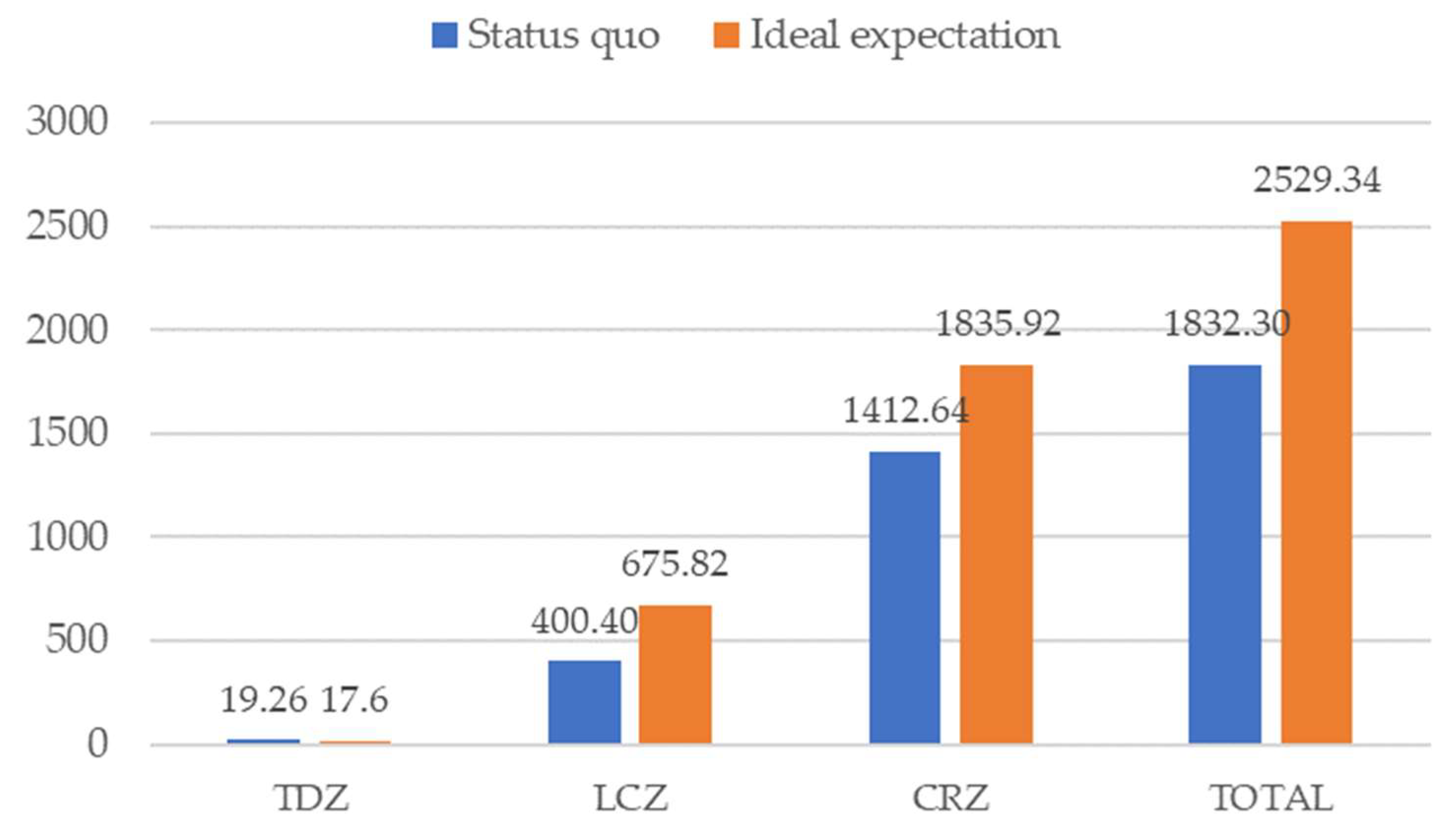
| Index | Current Value (yuan) | Ideal Planning Value (yuan) |
|---|---|---|
| TDZ | 19,260,712 | 17,603,034 (−9%) |
| LCZ | 400,400,976 | 675,816,894 (+69%) |
| CRZ | 1,412,640,400 | 1,835,915,501 (+30%) |
| TOTAL | 1,832,302,088 | 2,529,335,429 (+38%) |
Disclaimer/Publisher’s Note: The statements, opinions and data contained in all publications are solely those of the individual author(s) and contributor(s) and not of MDPI and/or the editor(s). MDPI and/or the editor(s) disclaim responsibility for any injury to people or property resulting from any ideas, methods, instructions or products referred to in the content. |
© 2023 by the authors. Licensee MDPI, Basel, Switzerland. This article is an open access article distributed under the terms and conditions of the Creative Commons Attribution (CC BY) license (https://creativecommons.org/licenses/by/4.0/).
Share and Cite
Guo, C.; Han, B.; Shu, C.; Ding, S.; Wang, H. Research on CLUFS and Its Application in Rapid Prediction of the Impact of Regulating Services Value in Construction Projects. Land 2023, 12, 2041. https://doi.org/10.3390/land12112041
Guo C, Han B, Shu C, Ding S, Wang H. Research on CLUFS and Its Application in Rapid Prediction of the Impact of Regulating Services Value in Construction Projects. Land. 2023; 12(11):2041. https://doi.org/10.3390/land12112041
Chicago/Turabian StyleGuo, Chenyang, Baolong Han, Chengji Shu, Shiyu Ding, and Haoqi Wang. 2023. "Research on CLUFS and Its Application in Rapid Prediction of the Impact of Regulating Services Value in Construction Projects" Land 12, no. 11: 2041. https://doi.org/10.3390/land12112041
APA StyleGuo, C., Han, B., Shu, C., Ding, S., & Wang, H. (2023). Research on CLUFS and Its Application in Rapid Prediction of the Impact of Regulating Services Value in Construction Projects. Land, 12(11), 2041. https://doi.org/10.3390/land12112041