Article

Conservation Responsibility for Priority Habitats under Future Climate Conditions: A Case Study on Juniperus drupacea Forests in Greece

by
Ioannis P. Kokkoris
1,†,
Konstantinos Kougioumoutzis
1,†,
Ioannis Charalampopoulos
2,
Ektor Apostolidis
3,
Ilias Apostolidis
3,
Arne Strid
4 and
Panayotis Dimopoulos
1,*
1
Laboratory of Botany, Department of Biology, University of Patras, 26504 Patras, Greece
2
Laboratory of General and Agricultural Meteorology, Department of Crop Science, Agricultural University of Athens, 11855 Athens, Greece
3
YLI Environmental Projects, Mavromateon 9, 10682 Athens, Greece
4
Bakkevej 6, DK-5853 Ørbæk, Denmark
*
Author to whom correspondence should be addressed.
These authors contributed equally to this work.
Land 2023, 12(11), 1976; https://doi.org/10.3390/land12111976
Submission received: 28 September 2023 / Revised: 21 October 2023 / Accepted: 23 October 2023 / Published: 26 October 2023

Abstract

:
Juniperus drupacea is a highly morphologically and genetically differentiated Tertiary relict, displaying a disjunct geographical range in the eastern Mediterranean. Being a thermophilous, light-demanding, and moderately drought-resistant tree, it survived the past climatic oscillations via altitudinal migration. The species has its westernmost range limit, and its only populations in the EU, in Mts Parnon and Taygetos (Greece). These populations are genetically isolated and distinct compared to their Asian counterparts. For Europe, Juniperus drupacea is categorized as an endangered species by the IUCN. Juniperus drupacea forests constitute a priority habitat for conservation in the EU. However, the species’ conservation status has never been assessed in Greece and the same applies to its climate and land-use change assessment. As Greece is already facing the short-term impacts of climate- and human-induced land-use change, studies dealing with the potential long-term climate- and land-use change effects on rare plant species distribution are urgently needed to implement efficient conservation management plans. Our research employs species distribution models, considering multiple climate scenarios and abiotic factors across different timeframes (2020s, 2050s, 2080s), factoring in the potential threat of forest fires. Additionally, we assess the species’ extinction risk at the European level, according to IUCN Criteria A and B. Study findings indicate significant habitat changes and an elevated extinction risk for Juniperus drupacea in Greece. To safeguard this priority habitat, informed conservation strategies, management plans, and policy making are recommended, based on our scientific insights.

1. Introduction

In the European Union, the Natura 2000 network is the cornerstone of nature conservation strategies and related policy efforts to safeguard irreplaceable elements of natural capital [1]. Recent research on the impact of climate change on species and ecosystems [2] indicates that climate change is affecting their distribution and threatening their survival (e.g., [3,4,5]). Furthermore, the ongoing and escalating impact of natural and human-induced pressures, such as forest fires and land-use change [6], demands specific measures, actions, and policies for the survival of species and habitats, particularly those with a restricted distribution range in the EU or globally.
Nature preservation in the EU is of utmost importance, and as such, certain conservation elements have been deemed priority areas of focus. These include species and habitats of priority importance that require protection (see Directive 92/43/EEC [7]). To prevent the further deterioration of these species and habitats, it is crucial that the threats they face be thoroughly examined and tackled or mitigated prior to reaching the tipping point of irreversible degradation or extinction conditions.
In Greece, one of the most diverse EU Member States in terms of species richness [8,9] and diversity of habitat types [10,11], eighteen (18) priority habitat types have been recorded. Notably, three of the four Mediterranean and Macaronesian mountainous coniferous forests are designated as priority habitats. These include (Sub-) Mediterranean pine forests with endemic black pines, Mediterranean Taxus baccata woods, and endemic forests of Juniperus spp. Within the priority habitat type of Juniperus spp. forests there are subcategories depending on the prevailing Juniperus species, e.g., forests dominated by Juniperus foetidissima, Juniperus excelsa, or Juniperus drupacea. In particular, Juniperus drupacea forests are only found in southeastern Peloponnisos, Greece, restricted to Mt Parnon (see, e.g., [12,13,14]), thus giving additional value to this forest priority habitat for its conservation and management as well as to the responsibility of Greece to protect its only distribution in the EU [10]. The Greek State recognizes the ecological importance of these forests and has designated them as a Preserved Monument of Nature since 1980 [15]. Since 1992, Juniperus drupacea forests of Mt Parnon have been included in the Natura 2000 network as Special Areas for Conservation and Special Protection Areas (Natura 2000 site code: GR 2520006). Moreover, Juniperus drupacea is considered in Europe as an endangered species, according to the International Union for the Conservation of Nature (IUCN) Red List for Europe [16], highlighting an already recorded survival issue.
It is important to point out that Greece is in a region experiencing substantial atmospheric variability due to climate change. More specifically, significant bioclimatic shifts within Juniperus drupacea’s distribution area are predicted by the De Martonne index, with discernible repercussions on native land cover and ecosystem dynamics [17].
Many local-scale studies have been conducted to investigate potential measures and actions for the survival of Juniperus drupacea and its corresponding habitat. These investigations encompass various aspects, including in vitro micropropagation possibilities [18], assessments of genetic and epigenetic diversity [19], and assessment of plant composition within its habitat [20]. Additionally, Walas et al. [21] projected the potential future range of the species, raising concerns about global endangerment. However, no studies have incorporated land-use and land-cover variables alongside climate change to document future predictions at the local scale. Furthermore, considering the recent history of extensive forest fires impacting neighboring (Sub-) Mediterranean forests with black pine in 2007, assessing the potential threat of forest fires within the broader distribution area of Juniperus drupacea in Greece becomes pertinent.
This study’s primary objective is to emphasize the urgency of nature conservation management and policy decisions, particularly for exceptional elements of natural capital. It considers the Juniperus drupacea forests of Mt Parnon and the species’ distribution in southeastern Peloponnisos as a case study for the EU. More specifically, estimates for the near and far future are provided for: (a) the future potential distribution of Juniperus drupacea under climate change scenarios, integrating the most recent Greek distribution database with land-use and land-cover change estimates, (b) Juniperus drupacea’s sensitivity, exposure, and vulnerability to climate and land-use change, (c) a preliminary IUCN extinction risk assessment at national and European scales, and (d) evaluating the potential threat of forest fires within the distribution area of Juniperus drupacea in Greece.
Our overarching aim is to reinforce the conservation goals of the Natura 2000 network for Juniperus drupacea, both as a singular species and as a protected forest and priority habitat, and to support the national initiatives aimed at compliance with the recently adopted EU Nature Restoration Law and Greece’s high responsibility to safeguard habitat conservation at the EU level [10].

2. Materials and Methods

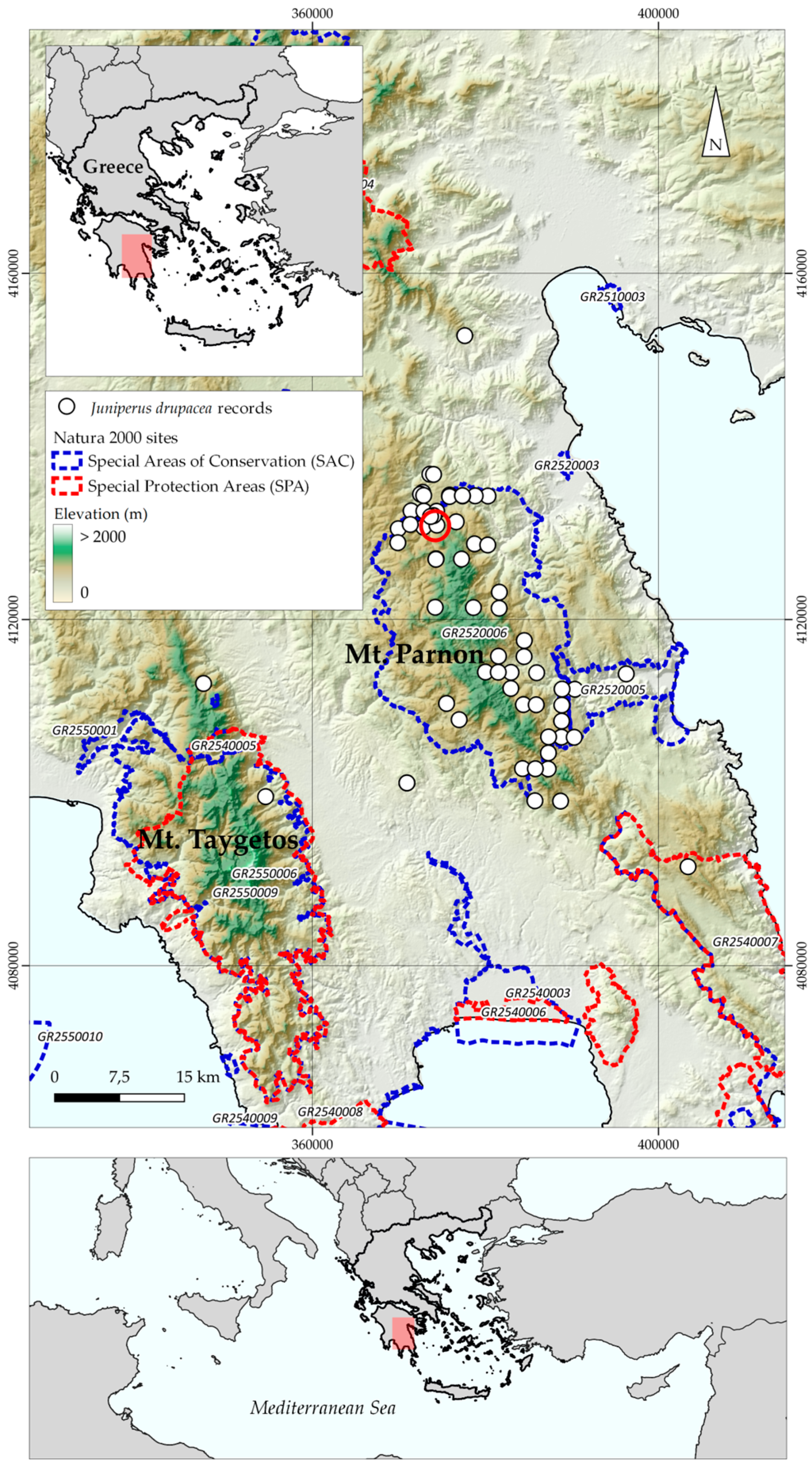
2.1. Species Occurrence Data

The European area of occurrence of Juniperus drupacea lies in Mt Parnon and Mt Taygetos (Figure 1). Detailed occurrence data were obtained from our own field observations and Natura 2000 network monitoring sample plots (2015, 2023) along with data derived from the Flora Hellenica Database (Strid, ongoing). We removed any points with coordinate uncertainty >1000 m and cleaned our coordinate dataset using the function “clean_coordinates” from the “CoordinateCleaner” 2.0.18 R package [22]. Then, we eliminated any duplicate points using the “elimCellDups” function from the “enmSdm” 0.5.3.3 R package [23]. Afterwards, we spatially thinned the remaining data using the “thin” function from the “spThin” 0.1.0 R package [24]. Finally, we estimated the Average Nearest-Neighbor Index for the cleaned, spatially thinned occurrence data to ensure that they were not geographically clustered [25], with the function “nni” from the “spatialEco” 1.3.7 R package [26]. Our cleaning and spatial thinning procedure followed [24,27].

2.2. Environmental Data

A baseline monthly climate dataset from 1981 to 2009 was generated, incorporating the standard 19 bioclimatic variables from WorldClim [28] alongside 16 supplementary environmental variables as delineated in [29], as most occurrence data were collected over the past three decades. We achieved a resolution of 30 arcseconds for this dataset. To generate these data, we utilized altitude data sourced from the WorldClim database [28] and worked with ClimateEU v4.63 and “dismo” 1.1.4 [30] and “envirem” 2.2 [29] R packages, adhering to the methodology outlined in [31,32,33]. Additionally, we integrated into our analysis soil data obtained from SoilGrids [34] and dynamic land-use/land-cover (LULC) data obtained from the Global land projection for 2015–2100, as developed by Chen et al. [35], at the same resolution as the other environmental variables. Furthermore, we estimated five topographical variables, namely aspect, heat load index, slope, topographic position index, and terrain ruggedness index, based on the aforementioned altitudinal data, used to construct the environmental variables mentioned earlier, using functions from “raster” 2.6.7 [36], “terra” 1.6-47 and “spatialEco” 1.2-0 R packages [26].
We created future climate data for:
(a) Three different periods, i.e., 2020s (2011–2040), 2050s (2041–2070) and 2080s (2071–2100);
(b) Three global circulation models (GCMs) (i.e., CCSM4, HadGEM2, and an ensemble of 15 global circulation models);
(c) Two Intergovernmental Panel on Climate Change scenarios from the representative concentration pathways family: RCP4.5 (mild scenario) and RCP8.5 (severe scenario), as described previously. We obtained future LULC data from Chen et al. [35] for the SSP1-RCP26 (the most sustainable path), SSP3-RCP70 (the most unsustainable path), and SSP5-RCP85 (rapid economic development depending on fossil fuel) scenarios [37]. The topographical and soil variables remained temporally constant, while the bioclimatic and the LULC variables display temporal variability. Improved precision in predicting the distribution of plant species can be achieved by incorporating high-resolution soil and topographical variables in species distribution models (SDMs) [38]. This is because such variables can accurately capture subtle changes in distribution [39,40]. However, relying solely on static variables may lead to an inadequate representation of future habitat suitability, potentially exaggerating the significance of these variables in SDMs [41,42,43]. Therefore, one should exercise caution when interpreting the importance of static predictors in the context of future projections [44].
In our subsequent analyses, we included twenty-three environmental variables that showed no collinearity issues, as assessed by Spearman rank correlation (<0.7) and variance inflation factor (<5) [45]. We performed multicollinearity tests with functions from the “usdm” 1.1.18 R package [46].

2.3. Species Distribution Models

Juniperus drupacea had a lower-than-10:1 occurrence–predictor ratio. We used the Random Forest algorithm and functions from the “ecospat” 3.1 [47] R package to model its realized climatic niche, following Valavi et al. [48,49,50] and Breiner et al. [51,52,53]. Using the alpha hull method [54], we estimated the background area of Juniperus drupacea in Greece utilizing functions from the “ConR” 1.1.1 R package [55]. We used the function “sample_pseudoabs” from the “flexsdm” 1.3.0 R package [56] to create pseudo-absences using a three-level process that allocates pseudo-absences based on a geographical buffer [41,57]. It constrains them environmentally and distributes them in environmental space using k-means clustering [56]. Following [58,59], we optimized the spatial cross-validation of our occurrences and pseudo-absences before model fitting using the “flexsdm” 1.3.0 R package function “part_sblock” [56] and compared model performance to null models [60] using seven different metrics [61,62,63,64,65] using functions from the ‘CalibratR’ 0.1.2, ‘DescTools’ 0.99.40, ‘ecospat’ 3.2, ‘enmSdm’ 0.5.3.2, ‘Metrics’ 0.1.4, ‘MLmetrics’ 1.1.1 and ‘modEvA’ 2.0 R packages [23,47,66,67,68,69]. We also applied the pooling procedure described by Collart et al. [70] to further evaluate our models. We ran the species distribution models for two separate sets of environmental variables that both included the temporally constant soil and topographical variables described previously. One set included the bioclimatic variables (the CC model) and the other included the bioclimatic variables alongside the LULC variables (the CC-LULCC model).
Well-calibrated (True Skill Statistic ≥ 0.8) models were employed to help identify potentially suitable areas for Juniperus drupacea during each analysis period.
We used the metric that maximizes sensitivity and specificity to produce binary maps for every GCM, RCP, SSP, and time-period combination [57,71,72]. As a precaution, all non-zero cells in the clamping mask for Juniperus drupacea were set to NA to address potential issues with predictions [73].
The directionality (increase/decrease in their potentially suitable area) and extent of the range shift of Juniperus drupacea were assessed with functions from the “biomod2” 3.3.7 R package [74], assuming that Juniperus drupacea could disperse across the entire study area. We used the “Humboldt” 1.0.0.420121 R package to check for niche truncation in our models [61]. Finally, we applied two metrics to account for environmental extrapolation (ExDet and the proportion of data nearby) using the “dsmextra” 1.1.4 R package [75,76].

2.4. Future IUCN Extinction Risk Assessment

We assigned Juniperus drupacea a preliminary IUCN threat category for each combination of GCM, RCP, SSP, and time period, in accordance with IUCN Criteria A and B, at the national and European levels. This evaluation was conducted using the “ConR” 1.1.1 R package [55] and R code accessible in [9]. It followed a framework previously applied in a broader geographic context in Greece by [77]. Finally, we looked into any differences between its projected and current IUCN extinction risk status, based on our models’ projections and their binary transformations. The current IUCN extinction risk status of Juniperus drupacea at the national and European level was estimated, to provide a more transparent comparison between its current and projected IUCN extinction status. The above analyses refer to this species’ preliminary extinction risk assessment within its European range.

2.5. Sensitivity, Exposure, and Vulnerability to Climate and Land-Use Change

In our analysis, we assessed species sensitivity, exposure, and vulnerability to climate and land-use changes using the climate niche factor analysis framework developed by Rinnan and Lawler [78]. To conduct these assessments, we employed functions from the CENFA 1.1.2 R package [79]. The degree to which the persistence of a species is determined by the climatic conditions of its current range is referred to as species sensitivity [80]. Generally, species more restricted by their current climate conditions are more sensitive to anticipated climate alterations. On the other hand, exposure quantifies the degree to which a species will encounter climate change within its range. This metric is calculated as a measure of dissimilarity between current and future climatic conditions within the species’ range. Higher dissimilarity values signify more significant disparities between the current and future climate conditions. Species sensitivity and exposure were calculated using the functions “cnfa” and “departure” in the CENFA R package. Given the prolonged lifespan of trees like Juniperus drupacea, which hinders rapid adaptation to climate fluctuations [81,82], we computed vulnerability to climate change as the geometric mean of sensitivity and exposure. This was achieved using the “vulnerability” function within the CENFA R package. We repeated these analyses for the CC and the CC-LULCC models, using only the temporally dynamic variables (i.e., excluding the soil and topographical variables).

2.6. Fire Danger Impact Assessment

To assess the potential risk of a forest fire within the Juniperus drupacea distribution area under current and future conditions, we employed a methodology that overlapped the Fire Weather Index (FWI) data onto species distribution models. The FWI corresponds to Fire Danger Classes as follows: Low: <11.2, Moderate: 11.2–21.3, High: 21.3–38.0, Very high: 38.0–50, Extreme: ≥50, Very extreme: ≥70 [83]. We gathered the FWI raster data from the Adaptive Greece Hub [84]. These data included annual mean values of the FWI, which are crucial for assessing fire danger based on weather conditions. Using the QGIS platform [85], we overlaid the FWI data onto the species distribution models’ outcomes. This step involved matching the spatial data of Juniperus drupacea distributions with the corresponding FWI values for current and future conditions. With the overlay complete, we conducted thematic mapping. This process allowed us to visualize the distribution of the FWI across all areas of Juniperus drupacea distribution in Greece. We performed this process for multiple scenarios, including the assessment of fire risk in current and future conditions. We gained insights into how fire danger may change over time by comparing the results from different scenarios.

3. Results

3.1. Species Distribution Models

The model’s performance was very good, with several evaluation metrics indicating high accuracy (Table S1) for both the CC and the CC-LULCC models. The pooled metrics were statistically significantly higher than the null models’ respective metrics (p < 0.01) and our models performed better than random models. Juniperus drupacea had minimal potential niche truncation value (Table S1). Cation exchange capacity of the soil and the proportion of clay particles in the fine earth fraction were the primary factors influencing the species’ distribution for the CC model and the CC-LULCC model, respectively (Table S2). We focus on the Ensemble GCM RCP 8.5 SSP1 scenario for the 2080s, as there were no significant differences between this scenario and others. Extrapolation novelty was minimal across various combinations of GCMs, RCPs, SSPs and periods. The proportion of analogous climate conditions ranged from 98.88% to 99.92%. Figure 2 presents the potential distribution for the current period (Figure 2a) and the 2080s (Figure 2b), depicting the severe decline in the species’ distribution.

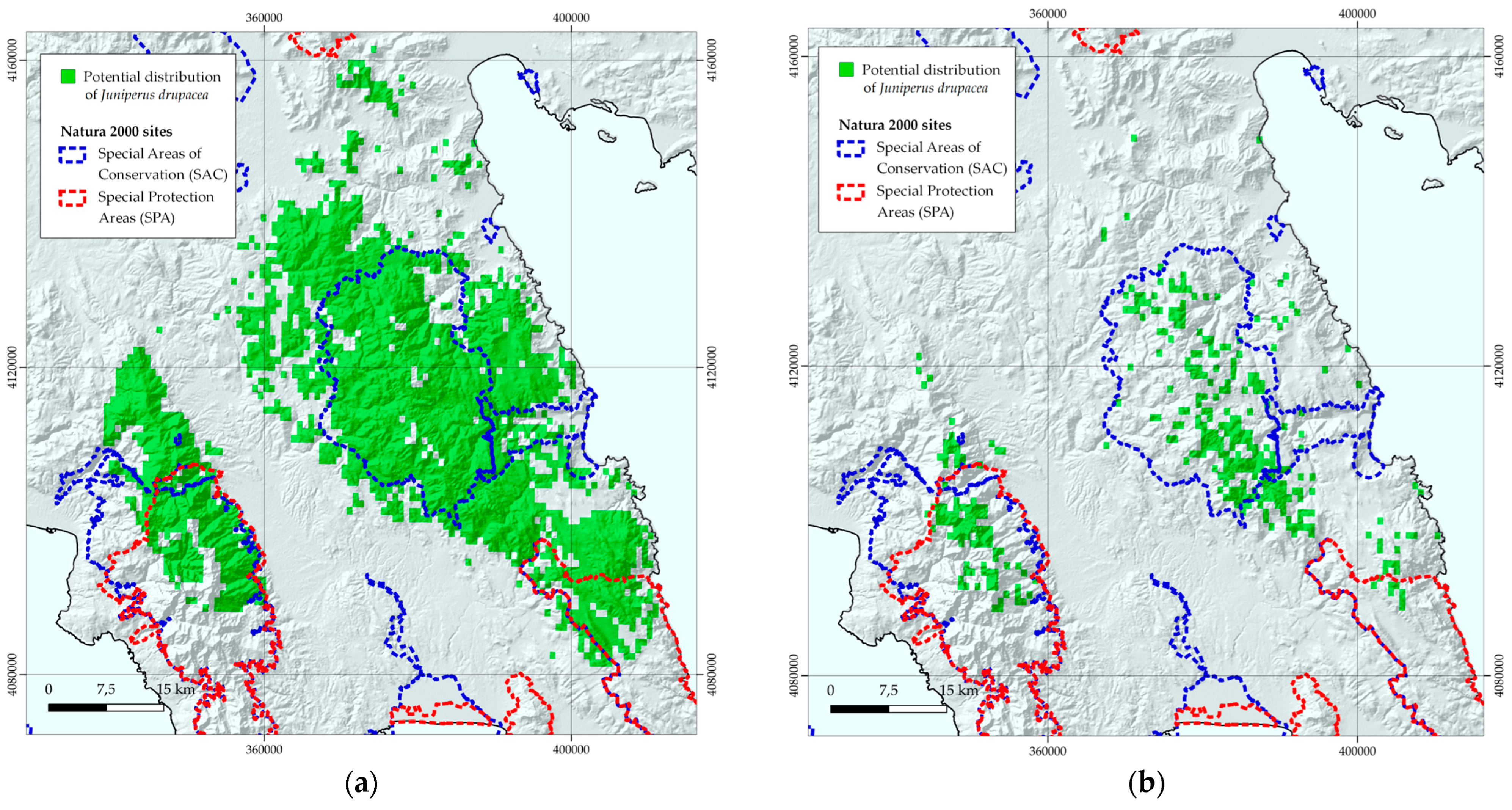
3.2. Habitat Suitability Range Change

Juniperus drupacea is projected to face rather small range contractions under any period and GCM/RCP/SSP combination, regarding the CC-LULCC model, with the median range contraction being 3.21% (Table S3). On the other hand, under the CC model, the anticipated range contractions are much more severe, as the median range contraction is 60.58% (Table S3). CCSM4 and the HadGEM2 GCM showed the lowest and highest median range contractions for any time slice and RCP combination for the CC model (Table S2). Regarding the CC-LULCC model, the median range contraction is highest in the Ensemble RCP 8.5 SSP1 during the 2080s and lowest in the CCSM4 RCP 4.5 SSP1 in the 2020s (Table S3). In both models, the median range contraction becomes progressively higher over time. Figure 3 presents the habitat suitability for Juniperus drupacea for the current period (Figure 3a) and the 2080s (Figure 3b), depicting the severe loss of suitable habitats in the future.

3.3. IUCN Extinction Risk Assessment

The extinction risk assessment under IUCN Criteria A and B and their combination characterize Juniperus drupacea for the current (baseline period) and all future scenarios at the national and European levels as follows:
  • Vulnerable, under the IUCN Criterion A assessment;
  • Least Concern or Near Threatened, under the IUCN Criterion B assessment;
  • Vulnerable, under the combined IUCN Criteria A and B assessment.
Table 1 presents the assessment for the SSP1 scenarios. Comprehensive results for all scenarios are available in Table S4.

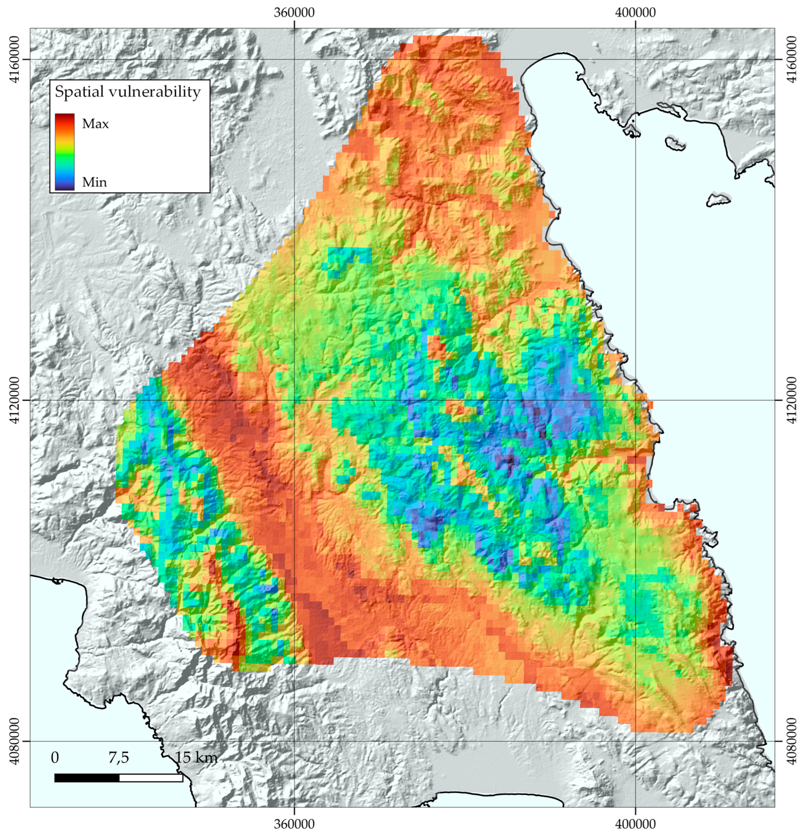
3.4. Sensitivity, Exposure, and Vulnerability to Climate and Land-Use Change

Juniperus drupacea’s sensitivity showed no significant difference between the CC and CC-LULCC models (Table S5). Over time, exposure increased gradually, reaching its peak in the 2080s for the HadGEM2 RCP 8.5 in both models (Table S5). However, it is important to note that these differences were not statistically significant across various periods, General Circulation Models (GCMs), representative concentration pathways (RCPs), and Shared Socioeconomic Pathways (SSPs).
In terms of vulnerability, the CC model exhibited statistically significantly higher values compared to the CC-LULCC model (1.40 ± 0.128 and 1.26 ± 0.066, respectively; values represent the median; Kruskal–Wallis: H = 17.325, df = 1, p < 0.001; Table S5). The same trend was observed for the HadGEM2 GCM, which displayed statistically significantly higher vulnerability values than the other two GCMs in our analysis (Kruskal–Wallis: H = 10.152, df = 2, p < 0.001; Table S5).
In examining the spatial distribution of vulnerability, we focused on the HadGEM2 RCP 8.5 scenario for the 2080s (i.e., the worst-case scenario regarding vulnerability) instead of the Ensemble RCP 8.5, which we chose to focus on regarding the outcomes of the species distribution models. High-vulnerability areas were predominantly situated in the western regions (between Mts Parnon and Taygetos) and the periphery of the species’ range (Figure 4).

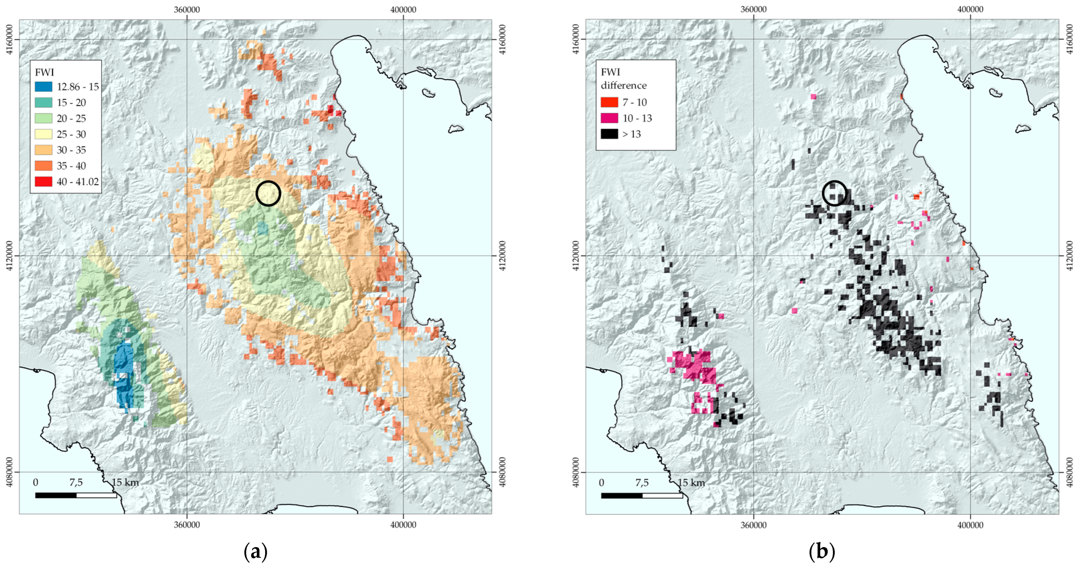
3.5. Wildfire Risk Assessment

The wildfire risk assessment for Juniperus drupacea’s potential distribution reveals that:
  • The FWI values range from 12.86 to 41.02, with a mean value of 29.43, for the total area of current potential distribution;
  • 57% of the area has a Fire Weather Index (FWI) greater than 30;
  • 16% of the area has an FWI exceeding 35;
  • Areas with higher FWI values are in Mt Parnon and its wider area (Figure 5);
  • In the strictly protected area (Preserved Monument of Nature), FWI values range from 27 to 29.
Projections for the near future (2050s) and far future (2080s) show consistent increases in mean FWI, ranging from +4.55 to +12.95 compared to the initial (current period) FWI value. Notably, for the worst-case scenario for the far future (2080s), the FWI value in all areas of Mt Parnon is above 30 and in the southern part it exceeds 46. The lowest values are recorded in the southwestern part of Mt Taygetos.
Figure 5 presents the FWI for the Juniperus drupacea distribution under conditions of the current scenario (baseline) (Figure 5a) and those of the worst-case scenario in the far future (2080s) (Figure 5b).

4. Discussion

Conservation science, environmental management, and policy have traditionally centered on safeguarding imperiled species and habitats. However, contemporary imperatives, rooted in current scientific insights, underscore the need for both qualitative and quantitative data to guide decisions in the context of climate change. Concurrently, the acquisition of local-scale baseline data emerges as a pivotal practice for monitoring ecosystem dynamics and associated services [86,87]. Setting clear thresholds to define a “good ecosystem condition” is vital. This practice facilitates the evaluation of present conditions against established standards (reference conditions), aligning seamlessly with the objectives of the EU Biodiversity Strategy for 2030, which calls upon EU Member States to assess and enhance their ecosystems for the betterment of society through ecosystem services [88]. Under this framework, our results provide a fine-scale dataset and baseline information for current and future conditions, considering different climatic and land-use/land-cover scenarios for protecting the priority habitat of forests and stands of Juniperus drupacea, unique to the EU.
Furthermore, our research builds upon Walas’s work [21], incorporating land-use and land change parameters. We also assess future scenarios for the distribution and extinction threat for the species in Greece, representing its westernmost distribution border. Moreover, we provide an updated yet preliminary IUCN extinction risk assessment at the European scale. We also estimated the species’ sensitivity, exposure, and vulnerability to climate and land-use change. We highlight the threat of forest fires to the species’ habitats and distribution in both current and future conditions, aiming to raise awareness of this climate and land-use-related risk in the designated “Preserved Monument of Nature” area and across the estimated distribution of Juniperus drupacea in the EU.

4.1. Management Implications

Juniperus drupacea, even though it has survived the climatic oscillations of the Last Glacial Maximum and the human-induced disturbances of its habitat over the past millennia, it seems it will face unprecedented threats in the foreseeable future that will most probably lead to the restriction of its range, at least on the European continent. It might be prudent to assess its genetic diversity, as has been conducted for other range-restricted or endemic taxa in Greece (e.g., see [4,89]), and this genetic assessment should be integrated into future modeling efforts, enhancing the precision of conservation strategies. Additionally, acclimation capacity and vulnerability thresholds of the species are also very important for more accurate model development (see, e.g., [90]).
In all future scenarios for the CC model, regardless of the global climate change model employed, Juniperus drupacea faces a staggering loss of over 50% of its habitat. Within the “Preserved Monument of Nature” area, the likelihood of maintaining a suitable habitat for this species dips below 50% across various GCM/RCP combinations and periods. Furthermore, the sobering conclusion of our preliminary extinction risk assessment is that the species remains vulnerable in both current and all conceivable future conditions. This phenomenon is, however, ameliorated when land-use/land-cover change is taken into account. We have to note, however, that our projections are somewhat conservative, given that the most important drivers of the species’ distribution are temporally static soil variables, namely the cation exchange capacity of the soil and the proportion of clay particles in the fine earth fraction for the CC and the CC-LULCC models, respectively. Nevertheless, soil variables are susceptible to alteration due to evolving (micro-) climatic conditions in the forthcoming decades (see [91,92,93,94,95]). This implies that Juniperus drupacea might encounter even more substantial shifts in its geographical range in the future than the ones we have predicted herein. This is further supported by the fact that Juniperus drupacea, at least in its European range, is highly sensitsive, exposed, and vulnerable to climate and land-use change, as it displays significantly lower sensitivity, higher exposure, and higher vulnerability values throughout its European range (Table S5; Figure 4) compared to other rare plants in other parts of the world [96,97,98,99]. This underscores the imperative for immediate action in management, policy, and conservation efforts for Juniperus drupacea as a species as well as for its forests. While the significance and distinctiveness of these forests have been well documented, most conservation endeavors have been centered on the “Preserved Monument of Nature” area, yielding commendable outcomes in habitat monitoring and management practices such as grazing management and ex situ conservation.
Nonetheless, our findings emphasise the critical need to incorporate considerations of future conditions into the formulation of protected area management plans. This is particularly crucial in scenarios with substantial loss of habitat suitability and an elevated risk of severe wildfires.
Additionally, our findings sound an alarm for this endangered and range-restricted species. If species like Juniperus drupacea, which is a long-lived, thermophilic, light-demanding, and moderately drought-resistant tree, experience range contractions due to climate and land-use changes, numerous taxa with small populations, limited genetic diversity, and fragmented distribution, notably many Greek endemic plants, could face imminent extinction. Consequently, it is imperative to investigate their vulnerability to climate and land-use change. Thus, we advocate undertaking similar analyses for at least some of the Greek endemic and/or range-restricted plants, acknowledging the need for Greece to align its expertise with other EU Member States and Mediterranean countries, since studies dealing with climate change impacts on Greek endemic plants are limited both in scope and range, focusing on a single taxon, a species complex, a mountain massif, or a single island [3,5,44,100,101].

4.2. Protection from Fire

Over the past two decades, there has been an alarming increase in forest fires, particularly in mountainous regions, affecting their associated vegetation types. Among these, Juniperus drupacea forests, characterized as highly flammable and lacking post-fire regeneration mechanisms, face significant vulnerability [102]. Our research underscores the pressing need to develop a forest fire prevention plan to protect Juniperus drupacea forests, as indicated by our current and future fire danger assessments utilizing the Fire Weather Index (FWI).
To date and to the best of our knowledge, no studies have addressed post-fire management and restoration strategies for Juniperus drupacea. Furthermore, recent investigations into this species’ reproduction characteristics and patterns hold immense value in devising conservation strategies that ensure species diversity and survival, providing essential insights into both in situ and ex situ regeneration attributes and patterns [103]. Solomou et al. [20] have also explored relevant ecological indicators that can inform management decisions and conservation policies, particularly in fire prevention and ecological preservation.
In addition to the measures mentioned above, we propose the establishment of two in situ reserves within the species’ projected future distribution range. These reserves, proposed to be established in the southern part of Mt Parnon and the central part of Mt Taygetos, will aim to secure reproductive populations of Juniperus drupacea in the face of uncontrolled forest fires, such as the 2007 megafire that encroached upon these forests. Within these reserves, meticulous monitoring will assess changes and relationships across various altitudinal and relief conditions as well as different grazing practices known to promote seed germination [102]. This initiative could be financially supported through the National Environment and Climate Change Agency, the governing body responsible for protected areas in Greece, and serves as a pioneering demonstration project at the EU level, mainly focusing on managing mountainous forest habitats not adapted to withstand fire events.

4.3. Awareness Raising

Effective conservation and decision making require active engagement from informed stakeholders [104]. For Juniperus drupacea forests, it is considered that public awareness is already relatively high, compared to the awareness of the importance of other habitat types or even of the Natura 2000 network [104]. All related projects dealing with the “Preserved Monument of Nature” area in Mt Parnon include dissemination actions and awareness-raising material, physical or digital, and, in some cases, include participatory methods to identify needs, problems, and solutions for the area. However, the impact of climate change has not yet been adequately communicated. Our study, which employs comprehensible thematic representations and statistical analyses, can be valuable for future awareness campaigns. These campaigns should prioritise climate change in decision making and inform evidence-based policies through participatory approaches. The proposed approach, using species distribution models, habitat suitability estimates, extinction risk assessment, and fire regimes for future scenarios, can be applied for any species to identify future status and act as a powerful awareness-raising tool (since it directly provides the scale of loss) for the general public, stakeholders, and decision and policymakers.

5. Conclusions

This study introduces a robust, science-driven framework for predicting the future status of endangered, range-restricted species like Juniperus drupacea and its forests that constitute a priority habitat for EU, found only in specific locations in southeastern Peloponnisos, Greece. Our method incorporates a broad spectrum of abiotic factors beyond traditional bioclimatic variables, encompassing soil composition, topography, and land use. This comprehensive approach offers critical insights into extinction risk and potential fire risk scenarios. Our methodology is universally applicable, providing a potent tool for raising awareness among the general public, stakeholders, and policymakers by quantifying and highlighting potential losses. Our findings urge for action, highlighting the fact that if plant species tolerant to harsh arid conditions, like Juniperus drupacea, experience range contractions due to climate and land-use changes, numerous other taxa, including the majority of Greek endemics, could soon become extinct due to their small populations, low genetic diversity, and scattered distribution. Therefore, it is imperative to study their vulnerability to climate and land-use changes. We propose carrying out similar analyses for at least some of the Greek endemic and/or range-restricted plants and recognising the need for Greece to align its expertise with other EU Member States and Mediterranean countries. By this, the present study complements previous works and moves one step forward for scientifically informed decisions on drafting targeted management plans for species and protected areas towards the implementation of the EU Biodiversity Strategy for 2030, simultaneously contributing to national responsibility for the conservation of this unique natural capital element.

Supplementary Materials

The following supporting information can be downloaded at: https://www.mdpi.com/article/10.3390/land12111976/s1, Table S1: Evaluation of models’ predictive performance via several discrimination (AUC, AUC-PR, TSS) and calibration (Brier score, Cohen’s kappa, Continuous Boyce Index (CBI), Somer’s D) metrics. We also provide the values referring to the pooled version of most of these metrics (the pooled version of AUC-PR and Brier’s score cannot at the moment be computed with the existing software). PTNI: Potential Niche Truncation Index. LULC: land use/land cover. CC: the climate change model. CC-LULCCC: the climate change and land-cover/land-use change model. The prefix “n” denotes the null models’ values for each metric; Table S2: Variable importance for Juniperus drupacea. LULC: land use/land cover. CC: the climate change model. CC-LULCCC: the climate change and land-cover/land-use change model. AIT: Thornthwaite’s aridity index. BDTT: Broadleaf deciduous temperate trees. BEST: Broadleaf evergreen temperate shrubs. C3: C3 grasses. CEC: Cation exchange capacity of the soil. CFVO: Volumetric fraction of coarse fragments. Clay: Proportion of clay particles in the fine earth fraction. HLI: Heat load index. MCT: count of the number of months with mean temperature greater than 10 °C. MDR: Mean diurnal range. NETT: Needle-leaf evergreen temperate trees. OCS: Organic carbon stocks. PDQ: Mean monthly potential evapotranspiration of the driest quarter. Sand: Proportion of sand particles in the fine earth fraction. Silt: Proportion of silt particles in the fine earth fraction. SOC: Soil organic carbon content in the fine earth fraction. TAR: Temperature annual range. TPI: Topographic position index. TS: Temperature seasonality; Table S3: Proportion of potential area loss for every time period and climate change model/scenario. GCM: Global Circulation Model. RCP: Representative Concentration Pathway. SSP: Shared Socioeconomic Pathway. LULC: land use/land cover. CC: the climate change model. CC-LULCCC: the climate change and land-cover/land-use change model; Table S4: IUCN extinction risk status for Juniperus drupacea based on Criteria A and B. GCM: Global Circulation Model. RCP: Representative Concentration Pathway. SSP: Shared Socioeconomic Pathway. VU: Vulnerable. LC or NT: Least Concern or Near Threatened. CC: the climate change model. CC-LULCCC: the climate change and land-cover/land-use change model; Table S5: Sensitivity, exposure, and vulnerability of Juniperus drupacea. GCM: Global Circulation Model. RCP: Representative Concentration Pathway. SSP: Shared Socioeconomic Pathway. CC: the climate change model. CC-LULCCC: the climate change and land-cover/land-use change model.

Author Contributions

Conceptualization, I.P.K., K.K., I.A. and P.D.; methodology, I.P.K., K.K. and I.C.; software, I.P.K., K.K. and I.C.; validation, I.P.K., K.K. and E.A.; formal analysis, I.P.K. and K.K.; investigation, I.P.K., K.K., E.A., I.A. and P.D.; resources, A.S. and P.D.; data curation, I.P.K., K.K., I.C., P.D. and A.S.; writing—original draft preparation, I.P.K. and K.K.; writing—review and editing, All authors.; visualization, I.P.K. and K.K.; supervision, P.D.; project administration, P.D. All authors have read and agreed to the published version of the manuscript.

Funding

This research received no external funding.

Data Availability Statement

Not applicable.

Conflicts of Interest

The authors declare no conflict of interest.

References

  1. Commission of the European Union Natura. 2000. Available online: https://ec.europa.eu/environment/nature/natura2000/index_en.htm (accessed on 20 September 2023).
  2. Charalampopoulos, I.; Droulia, F.; Kokkoris, I.P.; Dimopoulos, P. Future Bioclimatic Change of Agricultural and Natural Areas in Central Europe: An Ultra-High Resolution Analysis of the De Martonne Index. Water 2023, 15, 2563. [Google Scholar] [CrossRef]
  3. Kougioumoutzis, K.; Kokkoris, I.P.; Panitsa, M.; Trigas, P.; Strid, A.; Dimopoulos, P. Plant Diversity Patterns and Conservation Implications under Climate-Change Scenarios in the Mediterranean: The Case of Crete (Aegean, Greece). Diversity 2020, 12, 270. [Google Scholar] [CrossRef]
  4. Kougioumoutzis, K.; Kokkoris, I.P.; Panitsa, M.; Trigas, P.; Strid, A.; Dimopoulos, P. Spatial Phylogenetics, Biogeographical Patterns and Conservation Implications of the Endemic Flora of Crete (Aegean, Greece) under Climate Change Scenarios. Biology 2020, 9, 199. [Google Scholar] [CrossRef] [PubMed]
  5. Kougioumoutzis, K.; Kokkoris, I.P.; Strid, A.; Raus, T.; Dimopoulos, P. Climate-change impacts on the southernmost mediterranean arctic-alpine plant populations. Sustainability 2021, 13, 13778. [Google Scholar] [CrossRef]
  6. Barnosky, A.D.; Matzke, N.; Tomiya, S.; Wogan, G.O.U.; Swartz, B.; Quental, T.B.; Marshall, C.; Mcguire, J.L.; Lindsey, E.L.; Maguire, K.C.; et al. Has the Earth’s sixth mass extinction already arrived? Nature 2011, 471, 51–57. [Google Scholar] [CrossRef] [PubMed]
  7. Council of the European Communities (CEC). European Commission Council Directive 92/43/EEC of 21 May 1992 on the conservation of natural habitats and of wild fauna and flora. Off. J. Eur. Communities 1992, 206, 7–50. [Google Scholar]
  8. Kougioumoutzis, K.; Kokkoris, I.P.; Panitsa, M.; Kallimanis, A.; Strid, A.; Dimopoulos, P. Plant endemism centres and biodiversity hotspots in Greece. Biology 2021, 10, 72. [Google Scholar] [CrossRef]
  9. Stévart, T.; Dauby, G.; Lowry, P.P.; Blach-Overgaard, A.; Droissart, V.; Harris, D.J.; Mackinder, B.A.; Schatz, G.E.; Sonké, B.; Sosef, M.S.M.; et al. A third of the tropical African flora is potentially threatened with extinction. Sci. Adv. 2019, 5, eaax9444. [Google Scholar] [CrossRef]
  10. Dimopoulos, P.; Bergmeier, E.; Fischer, P. Natura 2000 Habitat Types of Greece Evaluated in the Light of Distribution, Threat and Responsibility. Biol. Environ. Proc. R. Ir. Acad. B 2006, 106, 175–187. [Google Scholar] [CrossRef]
  11. Biodiversity Information System for Europe: Greece. Available online: https://biodiversity.europa.eu/countries/greece (accessed on 25 September 2023).
  12. Boratynski, A.; Browicz, K.; Zielinski, J. Chorology of Trees and Shrubs in Greece; Institute of Dendrology, Polish Academy of Sciences: Kornik, Poland, 1992; ISBN 83-85599-04-5. [Google Scholar]
  13. Constantinidis, T.; Kalpoutzakis, E. Plant Guide to Mount Parnon and Moustos Wetland Protected Area: Endemic, Rare and Threatened Species; Management Body Mount Parnon: Moustos Wetland, Greece, 2015; ISBN 960-99424-4-X. [Google Scholar]
  14. Bergmeier, E. Plant Communities and Habitat Differentiation in the Mediterranean Coniferous Woodlands of Mt. Parnon (Greece). Folia Geobot. 2002, 37, 309–331. [Google Scholar] [CrossRef]
  15. Presidential Decree οn the declaration of historic and ancient trees or forest areas of exceptional importance as protected natural monuments. Hell. Gov. Gazzette 121 D 1980, 1417–1464.
  16. Ministry of Agriculture Juniperus drupacea (Europe assessment). The IUCN Red List of Threatened Species. Hell. Gov. Gazzette 1980, 1417–1464. [Google Scholar]
  17. Charalampopoulos, I.; Droulia, F.; Tsiros, I.X. Projecting Bioclimatic Change over the South-Eastern European Agricultural and Natural Areas via Ultrahigh-Resolution Analysis of the de Martonne Index. Atmosphere 2023, 14, 858. [Google Scholar] [CrossRef]
  18. Ioannidis, K.; Tomprou, I.; Panayiotopoulou, D.; Boutsios, S.; Daskalakou, E.N. Potential and Constraints on In Vitro Micropropagation of Juniperus drupacea Labill. Forests 2023, 14, 142. [Google Scholar] [CrossRef]
  19. Avramidou, E.V.; Korakaki, E.; Malliarou, E.; Boutsios, S. Studying the Genetic and the Epigenetic Diversity of the Endangered Species Juniperus drupacea Labill. towards Safeguarding Its Conservation in Greece. Forests 2023, 14, 1271. [Google Scholar] [CrossRef]
  20. Solomou, A.D.; Korakaki, E.; Avramidou, E.V.; Boutsios, S.; Oikonomidis, S.; Daskalakou, E.; Singh Bargali, S.; Solomou, A.D.; Korakaki, E.; Avramidou, E.V.; et al. Assessment of Herbaceous Plant Composition, Diversity, and Indicator Species in the Juniperus drupacea Forest Openings of the Mountain Parnonas in Greece. Sustainability 2023, 15, 13765. [Google Scholar] [CrossRef]
  21. Walas, Ł.; Sobierajska, K.; Ok, T.; Dönmez, A.A.; Kanoğlu, S.S.; Dagher-Kharrat, M.B.; Douaihy, B.; Romo, A.; Stephan, J.; Jasińska, A.K.; et al. Past, present, and future geographic range of an oro-Mediterranean Tertiary relict: The Juniperus drupacea case study. Reg. Environ. Chang. 2019, 19, 1507–1520. [Google Scholar] [CrossRef]
  22. Zizka, A.; Silvestro, D.; Andermann, T.; Azevedo, J.; Duarte Ritter, C.; Edler, D.; Farooq, H.; Herdean, A.; Ariza, M.; Scharn, R. CoordinateCleaner: Standardized cleaning of occurrence records from biological collection databases. Methods Ecol. Evol. 2019, 10, 744–751. [Google Scholar] [CrossRef]
  23. Smith, A.B. enmSdm: Tools for Modeling Species Niches and Distributions, R Package Version 0.5.1.5; R Core Team: Cary, CA, USA, 2020. [Google Scholar]
  24. Aiello-Lammens, M.E.; Boria, R.A.; Radosavljevic, A.; Vilela, B.; Anderson, R.P. spThin: An R package for spatial thinning of species occurrence records for use in ecological niche models. Ecography 2015, 38, 541–545. [Google Scholar] [CrossRef]
  25. Clark, P.J.; Evans, F.C. Distance to Nearest Neighbor as a Measure of Spatial Relationships in Populations. Ecology 1954, 35, 445–453. [Google Scholar] [CrossRef]
  26. Evans, J.S. spatialEco, R Package Version 1.2-0; R Core Team: Cary, CA, USA, 2019. [Google Scholar]
  27. Robertson, M.P.; Visser, V.; Hui, C. Biogeo: An R package for assessing and improving data quality of occurrence record datasets. Ecography 2016, 39, 394–401. [Google Scholar] [CrossRef]
  28. Fick, S.E.; Hijmans, R.J. WorldClim 2: New 1-km spatial resolution climate surfaces for global land areas. Int. J. Climatol. 2017, 37, 4302–4315. [Google Scholar] [CrossRef]
  29. Title, P.O.; Bemmels, J.B. ENVIREM: An expanded set of bioclimatic and topographic variables increases flexibility and improves performance of ecological niche modeling. Ecography 2018, 41, 291–307. [Google Scholar] [CrossRef]
  30. Hijmans, R.; Philipps, S.; Leathwick, J.; Elith, J. dismo: Species Distribution Modeling; R Package Version 1.1-4; R Core Team: Cary, CA, USA, 2017. [Google Scholar]
  31. Marchi, M.; Castellanos-Acuña, D.; Hamann, A.; Wang, T.; Ray, D.; Menzel, A. ClimateEU, scale-free climate normals, historical time series, and future projections for Europe. Sci. Data 2020, 7, 428. [Google Scholar] [CrossRef]
  32. Hamann, A.; Wang, T.; Spittlehouse, D.L.; Murdock, T.Q. A Comprehensive, High-Resolution Database of Historical and Projected Climate Surfaces for Western North America. Bull. Am. Meteorol. Soc. 2013, 94, 1307–1309. [Google Scholar] [CrossRef]
  33. Wang, T.; Hamann, A.; Spittlehouse, D.L.; Murdock, T.Q. ClimateWNA—High-Resolution Spatial Climate Data for Western North America. J. Appl. Meteorol. Climatol. 2012, 51, 16–29. [Google Scholar] [CrossRef]
  34. Hengl, T.; de Jesus, J.M.; Heuvelink, G.B.M.; Gonzalez, M.R.; Kilibarda, M.; Blagotić, A.; Shangguan, W.; Wright, M.N.; Geng, X.; Bauer-Marschallinger, B.; et al. SoilGrids250m: Global gridded soil information based on machine learning. PLoS ONE 2017, 12, e0169748. [Google Scholar] [CrossRef]
  35. Chen, G.; Li, X.; Liu, X. Global land projection based on plant functional types with a 1-km resolution under socio-climatic scenarios. Sci. Data 2022, 9, 125. [Google Scholar] [CrossRef]
  36. Hijmans, R.J. terra: Spatial Data Analysis. R Package Version 1.6-47. 2022. Available online: https://CRAN.R-project.org/package=terra (accessed on 2 October 2023).
  37. Cao, Y.; Wang, F.; Tseng, T.-H.; Carver, S.; Chen, X.; Zhao, J.; Yu, L.; Li, F.; Zhao, Z.; Yang, R. Identifying ecosystem service value and potential loss of wilderness areas in China to support post-2020 global biodiversity conservation. Sci. Total Environ. 2022, 846, 157348. [Google Scholar] [CrossRef]
  38. Lannuzel, G.; Balmot, J.; Dubos, N.; Thibault, M.; Fogliani, B.; Sanchez Mata, D. High-resolution topographic variables accurately predict the distribution of rare plant species for conservation area selection in a narrow-endemism hotspot in New Caledonia. Biodivers. Conserv. 2021, 30, 963–990. [Google Scholar] [CrossRef]
  39. Meineri, E.; Hylander, K. Fine-grain, large-domain climate models based on climate station and comprehensive topographic information improve microrefugia detection. Ecography 2017, 40, 1003–1013. [Google Scholar] [CrossRef]
  40. Tomlinson, S.; Lewandrowski, W.; Elliott, C.P.; Miller, B.P.; Turner, S.R. High-resolution distribution modeling of a threatened short-range endemic plant informed by edaphic factors. Ecol. Evol. 2020, 10, 763–777. [Google Scholar] [CrossRef] [PubMed]
  41. Barbet-Massin, M.; Jiguet, F.; Albert, C.H.; Thuiller, W. Selecting pseudo-absences for species distribution models: How, where and how many? Methods Ecol. Evol. 2012, 3, 327–338. [Google Scholar] [CrossRef]
  42. Sirami, C.; Caplat, P.; Popy, S.; Clamens, A.; Arlettaz, R.; Jiguet, F.; Brotons, L.; Martin, J.L. Impacts of global change on species distributions: Obstacles and solutions to integrate climate and land use. Glob. Ecol. Biogeogr. 2016, 26, 385–394. [Google Scholar] [CrossRef]
  43. Martin, Y.; Van Dyck, H.; Dendoncker, N.; Titeux, N. Testing instead of assuming the importance of land use change scenarios to model species distributions under climate change. Glob. Ecol. Biogeogr. 2013, 22, 1204–1216. [Google Scholar] [CrossRef]
  44. Kougioumoutzis, K.; Trigas, P.; Tsakiri, M.; Kokkoris, I.P.; Koumoutsou, E.; Dimopoulos, P.; Tzanoudakis, D.; Iatrou, G.; Panitsa, M. Climate and Land-Cover Change Impacts and Extinction Risk Assessment of Rare and Threatened Endemic Taxa of Chelmos-Vouraikos National Park (Peloponnese, Greece). Plants 2022, 11, 3548. [Google Scholar] [CrossRef] [PubMed]
  45. Dormann, C.F.; Elith, J.; Bacher, S.; Buchmann, C.; Carl, G.; Carré, G.; Marquéz, J.R.G.; Gruber, B.; Lafourcade, B.; Leitão, P.J.; et al. Collinearity: A review of methods to deal with it and a simulation study evaluating their performance. Ecography 2013, 36, 27–46. [Google Scholar] [CrossRef]
  46. Naimi, B.; Hamm, N.A.S.; Groen, T.A.; Skidmore, A.K.; Toxopeus, A.G. Where is positional uncertainty a problem for species distribution modelling? Ecography 2014, 37, 191–203. [Google Scholar] [CrossRef]
  47. Broennimann, O.; Di Cola, V.; Guisan, A. ecospat: Spatial Ecology Miscellaneous Methods, R Package Version 3.2; R Core Team: Cary, CA, USA, 2021. [Google Scholar]
  48. Valavi, R.; Elith, J.; Lahoz-Monfort, J.J.; Guillera-Arroita, G. Modelling species presence-only data with random forests. Ecography 2021, 44, 1731–1742. [Google Scholar] [CrossRef]
  49. Valavi, R.; Guillera-Arroita, G.; Lahoz-Monfort, J.J.; Elith, J. Predictive performance of presence-only species distribution models: A benchmark study with reproducible code. Ecol. Monogr. 2022, 92, e01486. [Google Scholar] [CrossRef]
  50. Valavi, R.; Elith, J.; Lahoz-Monfort, J.J.; Guillera-Arroita, G. Flexible species distribution modelling methods perform well on spatially separated testing data. Glob. Ecol. Biogeogr. 2023, 32, 369–383. [Google Scholar] [CrossRef]
  51. Breiner, F.T.; Nobis, M.P.; Bergamini, A.; Guisan, A. Optimizing ensembles of small models for predicting the distribution of species with few occurrences. Methods Ecol. Evol. 2018, 9, 802–808. [Google Scholar] [CrossRef]
  52. Breiner, F.T.; Guisan, A.; Nobis, M.P.; Bergamini, A. Including environmental niche information to improve IUCN Red List assessments. Divers. Distrib. 2017, 23, 484–495. [Google Scholar] [CrossRef]
  53. Breiner, F.T.; Guisan, A.; Bergamini, A.; Nobis, M.P. Overcoming limitations of modelling rare species by using ensembles of small models. Methods Ecol. Evol. 2015, 6, 1210–1218. [Google Scholar] [CrossRef]
  54. Meyer, L.; Diniz-Filho, J.A.F.; Lohmann, L.G. A comparison of hull methods for estimating species ranges and richness maps. Plant Ecol. Divers. 2017, 10, 389–401. [Google Scholar] [CrossRef]
  55. Dauby, G.; Stévart, T.; Droissart, V.; Cosiaux, A.; Deblauwe, V.; Simo-Droissart, M.; Sosef, M.S.M.; Lowry, P.P.; Schatz, G.E.; Gereau, R.E.; et al. ConR: An R package to assist large-scale multispecies preliminary conservation assessments using distribution data. Ecol. Evol. 2017, 7, 11292–11303. [Google Scholar] [CrossRef] [PubMed]
  56. Velazco, S.J.E.; Rose, M.B.; de Andrade, A.F.A.; Minoli, I.; Franklin, J. flexsdm: An r package for supporting a comprehensive and flexible species distribution modelling workflow. Methods Ecol. Evol. 2022, 13, 1661–1669. [Google Scholar] [CrossRef]
  57. Liu, C.; White, M.; Newell, G. Selecting thresholds for the prediction of species occurrence with presence-only data. J. Biogeogr. 2013, 40, 778–789. [Google Scholar] [CrossRef]
  58. Roberts, D.R.; Bahn, V.; Ciuti, S.; Boyce, M.S.; Elith, J.; Guillera-Arroita, G.; Hauenstein, S.; Lahoz-Monfort, J.J.; Schröder, B.; Thuiller, W.; et al. Cross-validation strategies for data with temporal, spatial, hierarchical, or phylogenetic structure. Ecography 2017, 40, 913–929. [Google Scholar] [CrossRef]
  59. Santini, L.; Benítez-López, A.; Maiorano, L.; Čengić, M.; Huijbregts, M.A.J. Assessing the reliability of species distribution projections in climate change research. Divers. Distrib. 2021, 27, 1035–1050. [Google Scholar] [CrossRef]
  60. Raes, N.; ter Steege, H. A null-model for significance testing of presence-only species distribution models. Ecography 2007, 30, 727–736. [Google Scholar] [CrossRef]
  61. Allouche, O.; Tsoar, A.; Kadmon, R. Assessing the accuracy of species distribution models: Prevalence, kappa and the true skill statistic (TSS). J. Appl. Ecol. 2006, 43, 1223–1232. [Google Scholar] [CrossRef]
  62. Hirzel, A.H.; Le Lay, G.; Helfer, V.; Randin, C.; Guisan, A. Evaluating the ability of habitat suitability models to predict species presences. Ecol. Modell. 2006, 199, 142–152. [Google Scholar] [CrossRef]
  63. Fielding, A.H.; Bell, J.F. A review of methods for the assessment of prediction errors in conservation presence/absence models. Environ. Conserv. 1997, 24, 38–49. [Google Scholar] [CrossRef]
  64. Sofaer, H.R.; Hoeting, J.A.; Jarnevich, C.S. The area under the precision-recall curve as a performance metric for rare binary events. Methods Ecol. Evol. 2019, 10, 565–577. [Google Scholar] [CrossRef]
  65. Liu, C.; White, M.; Newell, G. Measuring and comparing the accuracy of species distribution models with presence-absence data. Ecography 2011, 34, 232–243. [Google Scholar] [CrossRef]
  66. Hammer, B.; Frasco, M. metrics: Evaluation Metrics for Machine Learning; R Package Version 0.1.4; R Core Team: Cary, CA, USA, 2018. [Google Scholar]
  67. Márcia Barbosa, A.; Real, R.; Muñoz, A.R.; Brown, J.A. New measures for assessing model equilibrium and prediction mismatch in species distribution models. Divers. Distrib. 2013, 19, 1333–1338. [Google Scholar] [CrossRef]
  68. Schwarz, J.; Heider, D. GUESS: Projecting machine learning scores to well-calibrated probability estimates for clinical decision making. Bioinformatics 2019, 35, 2458–2465. [Google Scholar] [CrossRef]
  69. Signorell, A.; Aho, K.; Anderegg, N.; Aragon, T.; Arppe, A.; Baddeley, A.; Bolker, B.; Caeiro, F.; Champely, S.; Chessel, D. DescTools: Tools for Descriptive Statistics. R Package Version 0.99-40; R Core Team: Cary, CA, USA, 2021. [Google Scholar]
  70. Collart, F.; Hedenäs, L.; Broennimann, O.; Guisan, A.; Vanderpoorten, A. Intraspecific differentiation: Implications for niche and distribution modelling. J. Biogeogr. 2021, 48, 415–426. [Google Scholar] [CrossRef]
  71. Liu, C.; Berry, P.M.; Dawson, T.P.; Pearson, R.G. Selecting thresholds of occurrence in the prediction of species distributions. Ecography 2005, 28, 385–393. [Google Scholar] [CrossRef]
  72. Liu, C.; Newell, G.; White, M. On the selection of thresholds for predicting species occurrence with presence-only data. Ecol. Evol. 2016, 6, 337–348. [Google Scholar] [CrossRef] [PubMed]
  73. Elith, J.; Kearney, M.; Phillips, S. The art of modelling range-shifting species. Methods Ecol. Evol. 2010, 1, 330–342. [Google Scholar] [CrossRef]
  74. Thuiller, W.; Georges, D.; Engler, R.; Breiner, F. biomod2: Ensemble Platform for Species Distribution Modeling; R Core Team: Cary, CA, USA, 2016. [Google Scholar]
  75. Bouchet, P.J.; Miller, D.L.; Roberts, J.J.; Mannocci, L.; Harris, C.M.; Thomas, L. dsmextra: Extrapolation assessment tools for density surface models. Methods Ecol. Evol. 2020, 11, 1464–1469. [Google Scholar] [CrossRef]
  76. Mannocci, L.; Roberts, J.J.; Halpin, P.N.; Authier, M.; Boisseau, O.; Bradai, M.N.; Cañadas, A.; Chicote, C.; David, L.; Di-Méglio, N.; et al. Assessing cetacean surveys throughout the Mediterranean Sea: A gap analysis in environmental space. Sci. Rep. 2018, 8, 3126. [Google Scholar] [CrossRef] [PubMed]
  77. Kougioumoutzis, K.; Kokkoris, I.P.; Panitsa, M.; Strid, A.; Dimopoulos, P. Extinction Risk Assessment of the Greek Endemic Flora. Biology 2021, 10, 195. [Google Scholar] [CrossRef] [PubMed]
  78. Rinnan, D.S.; Lawler, J. Climate-niche factor analysis: A spatial approach to quantifying species vulnerability to climate change. Ecography 2019, 42, 1494–1503. [Google Scholar] [CrossRef]
  79. Rinnan, D.S. CENFA: Climate and Ecological Nich Factor Analysis. R Package Version 1.0.0. 2018. Available online: https://CRAN.R-project.org/package=CENFA (accessed on 2 October 2023).
  80. Hirzel, A.H.; Jacques, H.; Chessel, D.; Perrin, N. Ecological-Niche Factor Analysis: How to Compute Habitat-Suitability Maps without Absence Data? Ecology 2002, 83, 2027–2036. [Google Scholar] [CrossRef]
  81. Lindner, M.; Maroschek, M.; Netherer, S.; Kremer, A.; Barbati, A.; Garcia-Gonzalo, J.; Seidl, R.; Delzon, S.; Corona, P.; Kolström, M.; et al. Climate change impacts, adaptive capacity, and vulnerability of European forest ecosystems. For. Ecol. Manag. 2010, 259, 698–709. [Google Scholar] [CrossRef]
  82. Petit, R.J.; Hampe, A. Some Evolutionary Consequences of Being a Tree. Annu. Rev. Ecol. Evol. Syst. 2006, 37, 187–214. [Google Scholar] [CrossRef]
  83. Copernicus Emergency Management Service Fire Danger Forecast. Available online: https://effis.jrc.ec.europa.eu/about-effis/technical-background/fire-danger-forecast (accessed on 2 October 2023).
  84. Adaptive Greece Hub: National Hub for Climate Change Adaptation. Available online: https://geo.adaptivegreecehub.gr/ (accessed on 10 August 2023).
  85. QGIS Development Team. QGIS Geographic Information System. Open Source Geospatial Foundation Project. 2021. Available online: http://qgis.osgeo.org (accessed on 2 October 2023).
  86. United Nations; European Commission; Food and Agricultural Organization of the United Nations; Organization for Economic Co-operation and Development; World Bank. System of Environmental-Economic Accounting 2012: Experimental Ecosystem Accounting; United Nations: New York, NY, USA, 2014; ISBN 9789210559263. [Google Scholar]
  87. United Nations. System of Environmental-Economic Accounting— Ecosystem Accounting (SEEA EA). White Cover Publication, Pre-Edited Text Subject to Official Editing; United Nations: New York, NY, USA, 2021. [Google Scholar]
  88. Vallecillo, S.; Maes, J.; Teller, A.; Babí Almenar, J.; Barredo, J.; Trombetti, M.; Abdul Malak, D.; Paracchini, M.L.; Carré, A.; Addamo, A.; et al. EU-Wide Methodology to Map and Assess Ecosystem Condition towards a Common Approach Consistent with a Global Statistical Standard; European Commission: Luxembourg, 2022. [Google Scholar]
  89. Stathi, E.; Kougioumoutzis, K.; Abraham, E.M.; Trigas, P.; Ganopoulos, I.; Avramidou, E.V.; Tani, E. Population genetic variability and distribution of the endangered Greek endemic Cicer graecum under climate change scenarios. AoB Plants 2020, 12, plaa007. [Google Scholar] [CrossRef]
  90. Brodribb, T.J.; Powers, J.; Cochard, H.; Choat, B. Hanging by a thread? Forests and drought. Science 2020, 368, 261–266. [Google Scholar] [CrossRef] [PubMed]
  91. Kougioumoutzis, K.; Kotsakiozi, P.; Stathi, E.; Trigas, P.; Parmakelis, A. Conservation genetics of four critically endangered greek endemic plants: A preliminary assessment. Diversity 2021, 13, 152. [Google Scholar] [CrossRef]
  92. Castellari, S.; Kurnik, B. Climate Change, Impacts and Vulnerability in Europe; European Environment Agency: Copenhagen, Denmark, 2017; ISBN 9789292138356. [Google Scholar]
  93. Nearing, M.A.; Pruski, F.F.; O’Neal, M.R. Expected climate change impacts on soil erosion rates: A review. J. Soil Water Conserv. 2004, 59, 43–50. [Google Scholar]
  94. Borrelli, P.; Robinson, D.A.; Panagos, P.; Lugato, E.; Yang, J.E.; Alewell, C.; Wuepper, D.; Montanarella, L.; Ballabio, C. Land use and climate change impacts on global soil erosion by water (2015–2070). Proc. Natl. Acad. Sci. USA 2020, 117, 21994–22001. [Google Scholar] [CrossRef] [PubMed]
  95. Trnka, M.; Kersebaum, K.C.; Eitzinger, J.; Hayes, M.; Hlavinka, P.; Svoboda, M.; Dubrovský, M.; Semerádová, D.; Wardlow, B.; Pokorný, E.; et al. Consequences of climate change for the soil climate in Central Europe and the central plains of the United States. Clim. Chang. 2013, 120, 405–418. [Google Scholar] [CrossRef]
  96. Wang, W.T.; Guo, W.Y.; Jarvie, S.; Svenning, J.C. The fate of Meconopsis species in the Tibeto-Himalayan region under future climate change. Ecol. Evol. 2021, 11, 887–899. [Google Scholar] [CrossRef] [PubMed]
  97. Wang, W.; Yang, T.; Jin, L.; Jiang, J. Vulnerability of two Rhodiola species under climate change in the future. Biodivers. Sci. 2021, 29, 1620–1628. [Google Scholar] [CrossRef]
  98. Wang, W.-T.; Guo, W.-Y.; Jarvie, S.; Serra-Diaz, J.M.; Svenning, J.-C. Anthropogenic climate change increases vulnerability of Magnolia species more in Asia than in the Americas. Biol. Conserv. 2022, 265, 109425. [Google Scholar] [CrossRef]
  99. Hernández-Lambraño, R.E.; de la Cruz, D.R.; Agudo, J.Á.S. Effects of the Climate Change on Peripheral Populations of Hydrophytes: A Sensitivity Analysis for European Plant Species Based on Climate Preferences. Sustainability 2021, 13, 3147. [Google Scholar] [CrossRef]
  100. Charitonidou, M.; Kougioumoutzis, K.; Halley, J.M. An Orchid in Retrograde: Climate-Driven Range Shift Patterns of Ophrys helenae in Greece. Plants 2021, 10, 470. [Google Scholar] [CrossRef]
  101. Kougioumoutzis, K.; Papanikolaou, A.; Kokkoris, I.P.; Strid, A.; Dimopoulos, P.; Panitsa, M. Climate Change Impacts and Extinction Risk Assessment of Nepeta Representatives (Lamiaceae) in Greece. Sustainability 2022, 14, 4269. [Google Scholar] [CrossRef]
  102. Apostolidis, E. Dendrokedros Forest Management and Protection Study in the Area of The Holy Monastery of Malevis Parnona; YLI Environmental Projects: Athens, Greek, 2023. [Google Scholar]
  103. Study of the Germination Behaviour of Seeds for the Conservation of Two Native Woody Species of Greece: The Endangered Tree Cedar (Juniperus drupacea Labill.) and the Endemic Maple (Acer hyrcanum subsp. Reginae-Amaliae Orph. ex Boiss) of Parnonas (GR 2520). Available online: https://www.fria.gr/jacer.html?fbclid=IwAR0Izr_Q6AJ8PZk35HGRlE-VPc9_JsZ-AiIYPrfV9zQPCkK6k8gHn29h0bQ (accessed on 24 September 2023).
  104. Kokkoris, I.P.; Skuras, D.; Maniatis, Y.; Dimopoulos, P. Natura 2000 public awareness in EU: A prerequisite for successful conservation policy. Land Use Policy 2023, 125, 106482. [Google Scholar] [CrossRef]
Figure 1. (Top panel): Map of SE Peloponnisos, depicting Mt Parnon and Mt Taygetos (main areas of Juniperus drupacea distribution in Europe) and Natura 2000 sites of the wider area. The red circle indicates the designated “Preserved Monument of Nature” area. (Bottom panel): Study area within the Eastern Mediterranean.
Land 12 01976 g001
Figure 2. Potential distribution of Juniperus drupacea: (a) current (reference period); (b) projection for the 2080s, using the Ensemble RCP 8.5 SSP1 model.
Land 12 01976 g002
Figure 3. Habitat suitability for Juniperus drupacea: (a) Current (reference period); (b) projection for the 2080s, using the Ensemble RCP 8.5 SSP1 model.
Land 12 01976 g003
Figure 4. Spatial vulnerability of Juniperus drupacea in the 2080s for the CC model under the HadGEM2 RCP 8.5.
Land 12 01976 g004
Figure 5. Fire danger estimation using the Fire Weather Index (FWI) for the Juniperus drupacea distribution for (a) current (reference) and (b) future worst-case-scenario (2080s) conditions. Black circle corresponds to the designated as “Preserved Monument of Nature” area.
Land 12 01976 g005
Table 1. Extinction risk assessment for the different GCMs and RCPs under the SSP1 scenario in all three time steps, under IUCN Criteria A and B and their combination.
GCMRCPPeriodSSPIUCN Criterion AIUCN Criterion BBoth IUCN Criteria
current-reference-VulnerableLeast ConcernedVulnerable
Ensemble4.52011–2040
(2020s)
1VulnerableLeast ConcernedVulnerable
Ensemble4.52041–2070
(2050s)
1VulnerableLeast ConcernedVulnerable
Ensemble4.52071–2100
(2080s)
1VulnerableLeast ConcernedVulnerable
Ensemble8.52011–2040
(2020s)
1VulnerableLeast ConcernedVulnerable
Ensemble8.52041–2070
(2050s)
1VulnerableLeast ConcernedVulnerable
Ensemble8.52071–2100
(2080s)
1VulnerableLeast ConcernedVulnerable
Disclaimer/Publisher’s Note: The statements, opinions and data contained in all publications are solely those of the individual author(s) and contributor(s) and not of MDPI and/or the editor(s). MDPI and/or the editor(s) disclaim responsibility for any injury to people or property resulting from any ideas, methods, instructions or products referred to in the content.

