Abstract
Hillside systems are key centers of ecological and cultural diversity, providing humanity with goods (e.g., food) and vital services (e.g., prevention of landslides) and sustaining 25% of terrestrial biodiversity. However, historical land use practices over these landscapes have contributed to their degradation. In this work, the hillside systems (i.e., slope > 5%) of the agricultural-rural landscape in the Coastal range of Central Chile (32° S–34° S) was analyzed and integrated analysis methods were used for the identification of areas that are degraded and have agricultural potential. The criteria used to identify them include morphometric parameters, current land cover/use, and legal protection status. The hillside systems represent a 74% of the study area, and while 1.2% is currently used for agriculture (13,473 ha), there are 3.2 thousand hectares that could be potentially recovered for agriculture, representing 0.4% of the hillside systems and 0.3% of the study area. In contrast, there are 773,131 ha of hillside systems with natural vegetation in need of conservation and/or protection, representing 69.4% of the study area (93.9% of the hillside systems). The last are key for the resilience of the entire landscape, helping to maintain critical processes linked to the productivity of agricultural areas, especially in the context of climate change and recurrent droughts.
1. Introduction
Globally, between 1000 and 6000 million hectares of ice-free land surface (up to 66%) are degraded at diverse degrees [1]. This degradation has negative effects in the soil productivity due to erosion and other processes, such as nutrient depletion, acidity, salinity, or deficiency of organic matter. Many biophysical, socioeconomic, and political aspects influence the processes and factors of soil degradation [2]. They are worsened by the poor land use practices that have contributed to their degradation, estimating an average erosion rate of 12.7 Mg ha−1 year−1 [3]. Some of the worst practices are linked to agriculture, and excessive specialization, causing resource depletion, decreases in soil productivity, and endangering the preservation of landscapes as an economic, cultural, and environmental resource. The industrialization of agriculture has degraded traditional landscapes and their associated biodiversity, even interrupting the transmission of traditional knowledge necessary for the maintenance of the local landscape, and producing socioeconomic destabilizations in rural areas and damaging the competitiveness of agriculture in relation to other economic sectors [4]. The degradation of the environment, and the associated rural landscapes and their soils has roots in the fast technological, economic, and cultural changes of modern agriculture [4], especially due to agricultural abandonment, intensive agriculture, and nutrient losses in recent decades [5,6]. However, the increase in population and the limited availability of lands has led to new crops in the hillsides, causing novel and serious environmental and soil damages [6]. These adverse conditions can be worse if they are coordinated with land abandonment, and the derived geomorphological dynamics are not considered. Thus, it is necessary to consider the relationships among geographical, environmental, and landscape factors, such as morphometric parameters of relief, land use, and soil quality, especially in mountainous areas [7,8].
Hillside systems are key centers of ecological and cultural diversity. They cover 24% of the Earth’s land surface and are home to 12% of the world’s population, providing humanity with vital goods and services. They also support 25% of terrestrial biodiversity and have almost half of the world’s biodiversity hotspots [9]. The recovery of vegetation in hillside systems has been studied and practiced by researchers worldwide [10,11]. Within the Latin America context, Chile is the country with one of the highest percentages of lands forming hillside systems (45%) [12], but in addition, 49% of its area has degraded soils, with the northern zone covering an affected area three times greater than the southern zone [13]. In Chile, the agricultural lands cover an estimated area of 1.2 million hectares, and are concentrated between the administrative regions of Coquimbo and Los Lagos (29° S–43° S), which are the most populated regions of the country, with 14.3 million inhabitants (81% of national population). However, the use of conventional soil preparation systems in annual crops, based on intensive processes with agricultural machinery, has meant a great loss of soil organic matter (carbon loss) [14] (see Figure 1). Other changes in the last 400 years include the mis-preparation of farmland that involved the frequent clearing of vegetation (sometimes using fire), the rapid transformation of hillside systems in areas of intensive fruit farming [15], and the expansion of exotic forest plantations and urbanization. Finally, there is another additional driver of landscape change; Chile is frequently affected by climatological, hydrological, and geological disasters, and these changes should be added to the changes due to climate change and hydroclimatic disturbances, such as droughts, which have been recurrent and extensive in recent decades [16].
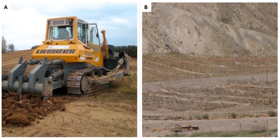
Figure 1.
Soil preparation in the study area: (A) shows intensive processes with agricultural machinery; (B) shows soil preparation performed processes performed by small farmers. Sources: (A) available in https://www.goharvest.cl/movimientos-de-tierra/ (accessed on 29 October 2022), (B) authors’ own photograph.
Considering this global and national problem, this work focuses on one of the historically farmed hillside systems of Chile. The agricultural-rural area of the coastal mountain range (Cordillera de la Costa in Spanish), is located in the administrative regions of Valparaíso and Santiago (32° S–34° S) of Central Chile, where 50.8% of the country’s population lives. The objective of this work was to analyze all the hillside systems of this landscape to identify those that are currently degraded but have the potential to be used (or reused) for agriculture after a process of soil recovery, and taking into consideration the current meteorological constrains. Likewise, this research aimed to identify other degraded hillside systems that should be ecologically restored or conserved in order to reinforce the ecological functions that help in agricultural production.
2. Materials and Methods
2.1. Study Area
The study area is located in the coastal mountain range (Cordillera de la Costa in Spanish) according to the geomorphological units of Chile (http://datos.cedeus.cl/layers/geonode:cl_unidades_geomorfologicas_geo; accessed on 1 September 2021), and other criteria that are explained later in the paper. They consider the conditions where small farmers of the study area are currently able to develop traditional agricultural practices.
2.1.1. Location and Characteristics of the Study Area
The study area is the entire coastal mountain range of the administrative regions of Valparaíso and Metropolitan Santiago (Figure 2), both located between 32.0° to 34.3° S and from 69.8° to 72.0° W, representing the home of 168,431 inhabitants. The northern area is within the Valparaíso region where the structure of the Cordillera de la Costa is characterized as an extension of the transversal valleys of the Coquimbo region (the northernmost area), since the physiognomy of the Central Depression is not distinguished as having direct articulation with the Andes Mountain range. Then, in the central area, the Cordillera de la Costa has a physiognomy that take the appearance of an elevated solid block that reaches heights of up to 2222 m above sea level (masl) (El Roble hill). This block acts as a climatic screen or orographic barrier with three hills taller than 2000 masl: Negro (2215 m), Caquis (2196 m), and Vizcachas (2046 m) hills, with average widths of approximately 70 km. Together, they form a barrier that alters and stops the advance of humid air masses coming from the Pacific Ocean. Finally, in the southern limit of the study area, after the interruption created by the passage of the Maipo–Mapocho fluvial systems, the Cordón de Cantillana emerges (33.75° and 34.17° S), a relief that reaches altitudes of 2281 masl (Cantillana hill) and 2076 masl (Horcón de Piedra hill). Thanks to long-term erosion processes, they gave rise to the basins and valleys that have made the development of agriculture, livestock, and human settlements possible. To understand the physical characteristics of the mountainous reliefs of this area, it is necessary to consider the complex interaction of the inherited dynamics with the tectonic, geomorphological, hydrological, and climatic processes that have contributed to their evolution and current geographical conformation.
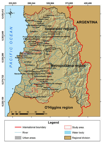
Figure 2.
Cartography of the study area. The regions that comprise the Valparaíso and Metropolitan regions are presented; the red lines define the area of the coastal cordillera, which corresponds to the area of interest.
In this area, the main morphological units: the Andes (Cordillera de los Andes), Central Depression, and Cordillera de la Costa, are arranged in the form of parallel strips with north–south development and are the product of the interactions associated with the subduction process of the Nazca plate under the South American plate. The coastal mountain range, therefore, is a relief originated from endogenous forces, and has evolved due to morphoclimatic processes as a unique morphological unit between the Aconcagua River basin (32° S) up to the Chacao Channel (42° S). In Central Chile, the Cordillera de la Costa shape a relief crossed by two massive basins born in the Andes: Aconcagua and Maipo. However, in the coastal mountain range, small hydrographic basins contribute to supplying water to small valleys formed in these reliefs. Some of them are the basins of the rivers Petorca, Ligua, Catapilco, Catemu, Limache, Lo Orozco, Puangue, and Carén.
From the climatic perspective, in association with the anticyclonic atmospheric circulation of these latitudes, the Cordillera de la Costa presents two types of opposite situations. The hillside systems facing the westerly winds, i.e., those facing the Pacific, are more humid due to the influence of oceanic humidity. In contrast, those reliefs that are oriented toward the east have high levels of aridity. The orientation of the relief to solar rays also influences these conditions: the hillside systems that are oriented toward the north are rather dry, and is the opposite situation for those facing the south. Therefore, the orientation and exposure of the terrain means a contrasted situation from the perspective of water availability, which not only favors or hinders potential agro-economic developments, but is also a factor that intervenes in their deterioration and that has been accentuated for several years in the context of a prolonged drought in this part of the country [17].
Hillside systems are a sequence of the sloping areas of a relief, which constitute the basic element of all landscapes and are a fundamental component of all geomorphological systems. The areas with slopes have a great variety of sizes and shapes, as well as names that allow for describing them as a geomorphological phenomenon: slope, flank, slope, and skirt [18], at least to a certain extent. In any case, a hillside can be considered a minimum unit of relief and therefore a part of the Earth’s surface. Its definition is therefore a complex issue; however, its essential characteristic is that it is inclined, with a slope angle greater than a minimum threshold (e.g., 5%), but less than a higher threshold (e.g., 30%) and therefore delimited by at least two morphological units that have a position higher or lower. From another point of view, this delimitation also depends on the size and scale considered in the definition and on the analysis of the slope [19].
2.1.2. Historical and Current Crop Types in the Rainfed Landscape of Hillside Systems
Historically, the agricultural activity carried out in hillside systems of rainfed landscapes was widely represented by traditional crops of lentils, wheat, chickpeas, peas, beans, potatoes, and strawberries only having irrigation thanks to seasonal rains. In addition, there were crops of tobacco, which are able to grow in areas with high seasonal rainfall, and production of charcoal from Vachellia caven, in areas where this species naturally grows, as dominant sclerophyllous scrub and/or forests [20]. In recent years, all these traditional crops have experienced a severe reduction, and agricultural producers have abandoned historical practices, only carrying them out on a small scale. This situation was caused by unsustainable practices that led to desertification and the soil impoverishment of hillside systems, and had the concurrent reinforcement of the mega-drought that has affected Chile since 2008 [21], which generated a significant impact on the soil productivity, mainly because the soil’s moisture retention capacity was severely affected [22]. In addition, the scarcity of easy solutions for aging farmers specialized in rainfed work coincides with the very rapid development of monoculture fruit trees (citrus and avocado) grown on hillside systems that significantly increase the degradation of the landscape.
2.2. Selection of Criteria That Allow the Classification of Slopes
To classify the hillside systems’ areas with the proper slope, exposition, and altitude of the study area and then identify which of them represent the degraded areas that require restoration, an integrated analysis was performed. This analysis included morphometric parameters, land cover/use, and legal protection status. Before identifying the hillside systems suitable for agriculture, the entire study area was classified to first obtain all the areas that did not represent areas with slopes (slope < 5%) using DEM Alos Palsar. Then, the product “Land cover of Chile” was reclassified selecting land cover types to identify the areas that should be conserved based on their ecological value. Finally, the degraded hillside systems that could be recovered for agricultural purposes were classified. All the steps are based on limitations or exclusionary zones defined in Table 1, considering national and international experiences [23,24,25,26]. They are mainly oriented to two criteria, one in relation to topography and the other in relation to land cover (IUCN and WRI, 2014). For the first criterion, three variables were established (altitude, slope, and exposure) that make suitable hillside systems for agriculture [23]. Regarding the slope, a suitable arable area was established between 5% and 30% [27,28], the ideal exposure was the exposure oriented to the north, to the northwest and northeast. With respect to the altitude variable, in reference to the predominant crops, 1300 masl [27,29] was considered an adequate maximum altitude due to feasibility issues related to irrigation, as cultivation occurs only to 500 m above the irrigation channels. The first step was to intersect slope and exposure variables, obtaining “area 1”. “Area 1” was then intersected with the set of “natural protected areas”, giving rise to “area 2”. “Area 2” was intersected with the “land cover” product from which the areas with agricultural potential were selected, obtaining “area 3”. Finally, “area 3” was intersected with the area covered by irrigation canals, considering a buffer area of 500 m. The first two variables were grounded on DEM Alos Palsar. GIS analyses were performed in ArcGIS 10.6 using spatial analyst tools such as “intersect”, “extract by attributes”, “extract by mask”, “reclassify”, “buffer”, “aspect” and “slope”. The methodological process and criteria are presented in Figure 3 and Table 1.

Table 1.
Criteria and exclusive areas for the identification of degraded hillsides and their sources.
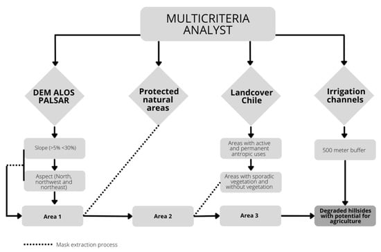
Figure 3.
Flowchart of the research procedure.
3. Results
3.1. Description of the Hillside Landscape and Its Potential for Agricultural Use
The hillside systems used as the study case cover 823,340 ha and dominate the landscape of the coastal mountain range, with 74% of the area, while 26% represent plain areas (Table 2, Figure 4a). In turn, 93.9% of the hillside systems are covered by natural vegetation, composed mainly of sclerophyllous and thorny forests and shrubs, representing an opportunity for conservation. They represent 69.4% of the total study area. This requires conservation because drought and the urban expansion are heavily impacting the vegetation in this area, and this type of vegetation is unique to the Mediterranean climate of central Chile having a high degree of endemism (Table 3, Figure 4b).
Table 2.
Description of study area (Figure 4a).
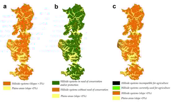
Figure 4.
Description of the structure and dominant coverage in the landscape of the coastal mountain range: (a) shows the hillside systems and plains areas; (b) shows the hillside systems in need of conservation due to their natural vegetation cover and the hillside systems that do not need conservation; (c) shows the hillside systems unsuitable (incompatible) for agriculture and those currently used for agriculture.
Table 3.
Need for conservation of the hillside systems (Figure 4b).
Then, Figure 4c (in black) shows the areas in hillside systems that are incompatible for agriculture; these correspond to land covered by permanent uses or areas that do not represent an opportunity for agricultural use, such as forest plantations, wetland areas, water bodies, and impermeable or constructed soils. In turn, the areas currently under cultivation represent only 1.2% of the total study area (see Table 4, Figure 4c), although the coastal highlands were historically characterized as an area with hillside agriculture due to the climatic compatibility with many types of crops.
Table 4.
Land uses in the hillside systems (Figure 4c).
3.2. Identification and Characterization of Hillside Systems that Are Degraded and that Have the Potential to Be Used for Agriculture after a Process of Soil Recovery
Considering the slope criterion (5% to 30%), 20.2% of the study area was suitable for crops (Figure 5a, Table 5). Moreover, the hillside systems with suitable solar exposure (sunny and mixed exposure) represented 61.6% of the analyzed area (Figure 5b). According to the altitude (irrigation feasibility < 500 m), 9.1% of the area was suitable (Figure 5c). Finally, the potential areas, because they do not have other permanent uses, represented 14.1% of the area (Figure 5d).
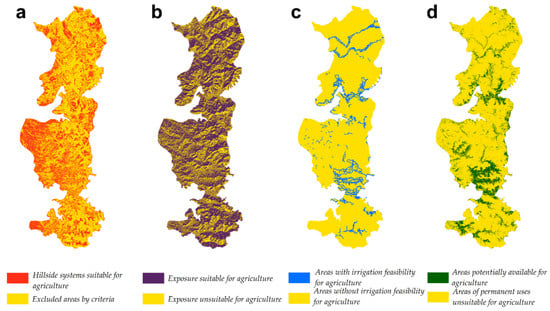
Figure 5.
Spatial representation of the criteria used for the integrated analysis of hillside systems: (a) shows the hillside systems suitable for agriculture; (b) shows the exposure suitable for agriculture; (c) shows the areas suitable for agriculture according to the feasibility of irrigation; and (d) shows the areas potentially available for agriculture because they do not have other permanent uses. The yellow color represents the excluded areas according to the selected criteria.
Table 5.
Description of criteria for the integrated analysis and their extension in the study area.
3.3. Integrated Analysis: Degraded Hillsides with Potential for Agriculture
The integrated analysis on the criteria of slope, exposure, altitude, and degraded land found that 0.3% of the study area and 0.4% of the hillside systems could potentially be used for agriculture, representing a total area of 3261.2 ha. The spatial distribution of this result can be observed in Figure 6.
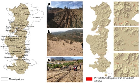
Figure 6.
Spatial representation of the result of the integrated analysis of criteria to establish areas with potential for agricultural recovery or restoration, together with the communes belonging to the studied area. Photographs show: (a) hillside systems degraded by deforestation in Las Palmas (Olmue), (b) hillside systems degraded by agriculture and later abandoned (since 1982) in Roco (La Ligua), and (c) soil restoration activities applying the Keyline technique in Las Palmas (Olmue).
For decision making, it is important to be able to recognize locally where these areas with potential for agriculture are located. Figure 6 shows the communes (local administrative areas) that are present in the study area. In addition, images of degraded hillside systems that were used for agriculture and that were abandoned are presented.
In total, 37 communes (territorial municipalities) were present in the study area, 10 of which had areas greater than 100 ha (Figure 7).
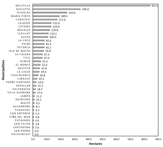
Figure 7.
Extension of degraded hillside systems for each commune of the studied area.
Following with the description of degraded hillside systems, it is worth mentioning that areas with slopes between 5% and 30% (or 2.9° to 16.7°) correspond to the total area with potential for agriculture (Table 6 and Table 7). With respect to the exposure, 65.4% of the identified areas have sunny exposure (Solana, northern exposition) and 34.6% have mixed solar exposure. According to land cover of Chile, the areas with restoration opportunities were concentrated in the lands covered with prairies and grasslands, with 80.8% and 19.20% of soils with little or no vegetation, respectively. This information is presented in Table 7.
Table 6.
Exposure of degraded hillside systems (slope 5–30%) with potential for agriculture after applying all the criteria described above.
Table 7.
Coverages of degraded hillside systems (slope 5–30%) with potential for agriculture after applying all the criteria described above.
3.4. Synthesis of Actions for Hillside Systems in the Coastal Mountain Range
As already stated, the hillside systems that require restoration actions for agricultural use cover 3261.2 ha representing 0.3% of the study area and 0.4% of the hillside systems suitable for agriculture (see Figure 8a). As shown in Figure 8b, there are hillside systems that could recover only if sufficient rainfall and rainfed crops could be restored. If these rainfed hillside systems were considered, the area could be increased significantly, both for agricultural and natural conservation purposes. However, due to the current rainfall regime, linked to the prolonged drought in Central Chile, it is impossible to consider this scenario as feasible. Actually, there are few cultivated lands, covering only 1.2% of the total study area (Figure 9).
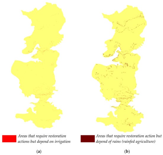
Figure 8.
Description of the hillside systems in the coastal mountain range able to be recovered considering two restoration options: (a) areas with availability of irrigation from the canals currently present in the study area; (b) areas that could be restored for agriculture with rainfed irrigation, which is not currently carried out due to the prolonged drought that affects the study area.
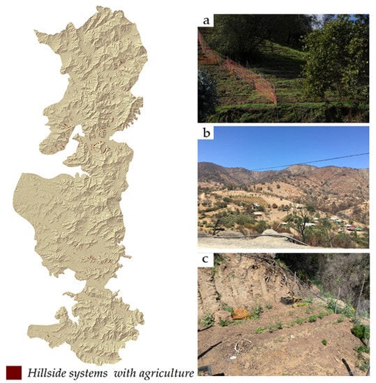
Figure 9.
Area of hillside systems with agriculture. Photographs (a,b) show examples of small-scale agriculture in the studied area, and (c) shows an example of agricultural restoration on degraded hillside systems.
To recover the degraded hillside systems, it is necessary to first restore the ecological functionality of these systems, recovering the stability and generating better microclimatic conditions, to only then be able to cultivate agricultural crops. In this sense, Nature-Based Solutions (NBS) are techniques that replicate the work that nature already carries out [30] and are increasingly valued in international discourses concerning climate change. At the same time, the implementation costs of these techniques are significantly lower than traditional engineering works [31]. One of these NBS corresponds to the Keyline technique, with a geomorphological approach, whose objective is to provide an effortless way to conserve rainwater falling on the soil, delay its evaporation, and use this moisture to rapidly increase soil fertility and stability, through the construction of terraces considering contour lines and infiltration ditches [32].
4. Discussion
This work identified hillside systems that are degraded and have the potential for agricultural use. All of them can be subject to soil restoration actions. These areas were characterized with an orientation initially based on former rainfed agriculture, a type of family farm or subsistence agriculture that cultivated vegetables especially. Currently, this type of agriculture is not found in the area, due to water scarcity. The degraded hillside systems that met these requirements represented a low percentage of the landscape, but could be considered as an opportunity to apply low-impact subsistence agriculture and reincorporate the planting of vegetables. Finally, 93.9% of the hillside systems (773,132 ha) are covered by natural vegetation. This represents a good indicator of biodiversity based on the state of degradation and water scarcity that occurs in the area but that require conservation actions to strengthen the resilience of the entire landscape, especially in the context of climate change and recurrent droughts.
4.1. Contributions of Integrated Analysis Methodologies in the Location of Sites Suitable for Agriculture
Integrated analysis methodologies are commonly used for their feasibility of generating useful information for decision making [33,34,35]. In this study, the criteria applied were slope, altitude, exposure, and types of land cover. The land cover product applied [10] is representative of 2014, but is also the most updated product at the national and regional levels; however, there may currently be even more degraded areas that require diverse types of restoration, due to the severe drought that has affected the area since 2010 [16].
Soil quality attributes are strongly related to topographic properties such as slope position, slope gradient, and slope aspect. They can be key to identifying optimal areas for certain fruit trees but not for vegetable crops since they do not require greater requirements [8,23]. In addition, the area corresponds to a Mediterranean climate, so it was considered unnecessary to establish specific parameters for each type of vegetable, and a general approach could be used.
The use of multicriteria analysis accompanied by an analytical hierarchy have excellent potential for decision making and evaluating different alternatives with minimum bias [6,7,8,9,10,11,12,13,14,15,16,17,18,19,20,21,22,23,24,25,26,27,28,29,30,31,32,33,34,35,36], as well as the use of techniques that order preference by similarity (TOPSIS) [37]. In this study, these types of methods were not applied, and weights were not generated for the criteria because they all had the same importance in the analysis, which was to determine which areas were suitable for agriculture in general rather than for any specific type of crop. This type of more detailed analysis would require more specifications, such as irrigation, humidity, temperature, and soil type.
The area identified in this work as the object of restoration actions for agricultural purposes is highly conditioned by the drought that affects Central Chile. The decreased rainfalls restrict the possibilities of traditional rainfed crops in hillside systems, therefore it is necessary to consider only the areas close to the irrigation canals.
4.2. Importance of Restoration and Conservation in Hillside Systems
The global impact of land use change on soil erosion, in the 21st century, has substantial implications for land productivity and in turn, worldwide socio-economic conditions [3]. Establishing degraded areas, in the case of this study helps with the planning of more sustainable landscapes and ecological management strategies that respond in the long term [2]. Many of the degraded hillside systems are currently abandoned areas that at once were agriculturally active. Land abandonment is a consequence of socioeconomic changes connected with the globalization of agriculture and related demographic processes that move rural populations to towns and cities and result in the neglect of traditional rural landscapes that are less appropriate for the development of agriculture on an industrial scale [4]. The abandonment of arable land also generates a large loss of soil organic carbon, and studies show that the conversion of agricultural land to native vegetation causes an increase in soil organic carbon [38]. Although the best option is a restoration effort with natural vegetation [39], there are areas that are already vegetated, and what is proposed to be restored in this study are hillside systems that meet the criteria for agriculture that correspond only to 0.3% of the landscape. One of the excluding variables is native vegetation, so the hillside systems that are naturally vegetated were not considered as potentially recoverable for agricultural use. Although the results obtained identified areas that represent a low percentage of the study area, it gives the possibility of focusing efforts on recovering degraded soils, as a measure of soil restoration, which is a new opportunity for small farmers in synergy with the conservation of areas with natural vegetation. The conservation of natural vegetation is very important, especially if they are in areas with steeper slopes, due to its ability to retain moisture, reduce surface runoff, and maintain water flows, something that is very beneficial in agricultural practices.
Restoring soils to rehabilitate them for agriculture also generates benefits for people, since it is a reliable source of food and essential for human existence. Agriculture also provides income and employment to communities and rural people along the food supply chain, and land use and topography are two of the main factors affecting the accumulation of soil organic carbon in eroded mountain regions [40,41]. From the perspective of the ecosystem services provided by agroecosystems, it is key to help to the sustainability of the ecological functions delivered, because they facilitate the regulation of the quality of soil and water, as well as the cycling of carbon and other nutrients, and sedimentation processes. This accompanied by agricultural sustainability, which includes aspects such as environmental security, public health, and soil fertility, is a useful tool to restore degraded soils [42]. It is necessary to apply solid planning strategies using a multidisciplinary approach that considers geographic, environmental, and landscape factors as variables that interact with each other and with social and economic aspects [7,43].
The incorporation of new areas to the hillside systems could consider other types of implications that affect the Mediterranean climate zones in central Chile, such as the persistence of droughts and areas potentially generating landslides due to the combination of factors related to tectonics (rock alteration and earthquakes) or heavy rainfall. This implies, therefore, the need to consider variables under the perspective of a risk analysis, which can be addressed in subsequent studies.
5. Conclusions
Agricultural activity on the hillside systems of the study area represents only 1.2% of the total area studied. This area could be increased by 25%, since 0.3% of the studied landscape could be available to reactivate the productive area and reactivate rainfed agriculture. This is positive, since these crops are located near the main cities of Central Chile, which generate great demand for food. In addition, there are 198,481 ha. that should be restored as centers of ecological diversity, reinforcing the ecological goods and services that can strengthen agricultural processes.
Author Contributions
Conceptualization, R.L. and D.M.-R.; methodology, D.M.-R. and F.D.l.B.; software, D.M.-R. and R.L.; validation, F.D.l.B. and H.M.; investigation, R.L., D.M.-R. and F.D.l.B.; writing—original draft preparation, R.L.; writing—review and editing, F.D.l.B., D.M.-R. and H.M.; supervision, F.D.l.B. All authors have read and agreed to the published version of the manuscript.
Funding
This research was funded by the National Research and Development Agency ANID, Chile, through grants ANID/REGIONAL/R19F10017 and ANID REGIONAL/CERES/R19A10002.
Institutional Review Board Statement
Not applicable.
Informed Consent Statement
Not applicable.
Data Availability Statement
Not applicable.
Acknowledgments
The authors acknowledge the contributions ANID/REGIONAL/R19F10017 and ANID REGIONAL/CERES/R19A10002.
Conflicts of Interest
The authors declare no conflict of interest.
References
- Carr, T.W.; Balkovič, J.; Dodds, P.E.; Folberth, C.; Skalský, R. The impact of water erosion on global maize and wheat productivity. Agric. Ecosyst. Environ. 2021, 322, 107655. [Google Scholar] [CrossRef]
- Talukder, B. Multi-Criteria Decision Analysis (MCDA) Technique for Evaluating Health Status of Landscape Ecology. In Landscape Ecology for Sustainable Society; Springer: Cham, Switzerland, 2018; pp. 39–49. [Google Scholar] [CrossRef]
- Borrelli, P.; Lugato, E.; Montanarella, L.; Panagos, P. A New Assessment of Soil Loss Due to Wind Erosion in European Agricultural Soils Using a Quantitative Spatially Distributed Modelling Approach. Land Degrad. Dev. 2017, 28, 335–344. [Google Scholar] [CrossRef]
- Agnoletti, M. Rural landscape, nature conservation and culture: Some notes on research trends and management approaches from a (southern) European perspective. Landsc. Urban Plan. 2014, 126, 66–73. [Google Scholar] [CrossRef]
- Zhang, W.; Li, H.; Pueppke, S.G.; Diao, Y.; Nie, X.; Geng, J.; Chen, D.; Pang, J. Nutrient loss is sensitive to land cover changes and slope gradients of agricultural hillsides: Evidence from four contrasting pond systems in a hilly catchment. Agric. Water Manag. 2020, 237, 106165. [Google Scholar] [CrossRef]
- Yi, J.; Zeng, Q.; Mei, T.; Zhang, S.; Li, Q.; Wang, M.; Tan, W. Disentangling drivers of soil microbial nutrient limitation in intensive agricultural and natural ecosystems. Sci. Total Environ. 2022, 806, 150555. [Google Scholar] [CrossRef] [PubMed]
- Tortora, A.; Statuto, D.; Picuno, P. Rural landscape planning through spatial modelling and image processing of historical maps. Land Use Policy 2015, 42, 71–82. [Google Scholar] [CrossRef]
- Nabiollahi, K.; Golmohamadi, F.; Taghizadeh-Mehrjardi, R.; Kerry, R.; Davari, M. Assessing the effects of slope gradient and land use change on soil quality degradation through digital mapping of soil quality indices and soil loss rate. Geoderma 2018, 318, 16–28. [Google Scholar] [CrossRef]
- García-Llamas, P.; Geijzendorffer, I.R.; García-Nieto, A.P.; Calvo, L.; Suárez-Seoane, S.; Cramer, W. Impact of land cover change on ecosystem service supply in mountain systems: A case study in the Cantabrian Mountains (NW of Spain). Reg. Environ. Chang. 2019, 19, 529–542. [Google Scholar] [CrossRef]
- Zhao, X.; Li, Z.; Robeson, M.D.; Hu, J.; Zhu, Q. Application of erosion-resistant fibers in the recovery of vegetation on steep slopes in the Loess Plateau of China. Catena 2018, 160, 233–241. [Google Scholar] [CrossRef]
- Gobinath, R.; Ganapathy, G.; Gayathiri, E.; Salunkhe, A.A.; Pourghasemi, H.R. Ecoengineering practices for soil degradation protection of vulnerable hill slopes. In Computers in Earth and Environmental Sciences; Elsevier: Amsterdam, The Netherlands, 2022; pp. 255–270. [Google Scholar] [CrossRef]
- Benites, J.; Saintraint, D.; Morimoto, K. Degradación de Tierras y Producción Agrícola en Argentina, Bolivia, Brasil, Chile y Paraguay; En: Erosión de Suelos en América Latina, Organización delas Naciones Unidas para la Agricultura y la Alimentación; Oficina Regional de la FAO para América Latina y el Caribe: Santiago, Chile, 1994; 219p. [Google Scholar]
- Berasaluce, M.; Díaz-Siefer, P.; Rodríguez-Díaz, P.; Mena-Carrasco, M.; Ibarra, J.T.; Celis-Diez, J.L.; Mondaca, P. Social-Environmental Conflicts in Chile: Is There Any Potential for an Ecological Constitution? Sustainability 2021, 13, 12701. [Google Scholar] [CrossRef]
- Cartes, G. Degradación de Suelos Agrícolas y el SIRSD-S. 2013, pp. 1–6, Oficina de Estudios y Políticas Agrarias. Available online: https://www.odepa.gob.cl/wp-content/uploads/2013/10/SueloAgricola201310.pdf (accessed on 20 October 2021).
- Ginocchio, R.; Melo, O.; Pliscoff, P.; Camus, P.; Arellano, E.C. Conflicto entre la intensificación de la agricultura y la conservación de la biodiversidad en Chile: Alternativas para la conciliación. Temas Agenda Pública 2019, 15, 1–24. [Google Scholar]
- Zúñiga, F.; Jaime, M.; Salazar, C. Crop farming adaptation to droughts in small-scale dryland agriculture in Chile. Water Resour. Econ. 2021, 34, 100176. [Google Scholar] [CrossRef]
- Muñoz Castillo, C.G. Rol de la Orografía Costera en la Precipitación de Chile Central: Análisis y Simulación para Casos de Tormenta Cálida y Tormenta Fría. Tesis para Optar al Grado de Magisterio en Ciencias Mención Geofísica. Master’s Thesis, Universidad de Chile, Santiago, Chile, 2014. [Google Scholar]
- Goudie, A. Encyclopedia of Geomorphology; Routledge, Taylor and Francis Group: New York, NY, USA, 2006; Volume 2, p. 1156. [Google Scholar]
- Dehn, M.; Gärtner, H.; Dikau, R. Principles of semantic modeling of landform structures. Comput. Geosci. 2001, 27, 1005–1010. [Google Scholar] [CrossRef]
- Canales, A.; Canales, M.; Hernández, M. Trabajo y territorio en el nuevo agro chileno. Un estudio de commuters en tres comarcas del Valle Central. EURE 2018, 44, 5–28. [Google Scholar] [CrossRef]
- Huang, J.; Yu, H.; Guan, X.; Wang, G.; Guo, R. Accelerated dryland expansion under climate change. Nat. Clim. Chang. 2016, 6, 166–171. [Google Scholar] [CrossRef]
- Feddema, J.; Freire, S.M. Soil degradation, global warming and climate impacts. Clim. Res. 2001, 17, 209–216. [Google Scholar] [CrossRef]
- Tercan, E.; Dereli, M.A.; Tapkin, S. A GIS–based multi–criteria evaluation for MSW landfill site selection in Antalya, Burdur, Isparta planning zone in Turkey. Environ. Earth Sci. 2020, 79, 246. [Google Scholar] [CrossRef]
- Selim, S.; Koc-San, D.; Selim, C.; San, B.T. Site selection for avocado cultivation using GIS and multi-criteria decision analyses: Case study of Antalya, Turkey. Comput. Electron. Agric. 2018, 154, 450–459. [Google Scholar] [CrossRef]
- De Cos Guerra, O. SIG y evaluación multicriterio: Propuesta metodológica para cuantificar el grado de metropolización en el territorio. Mapping 2007, 116, 6–12. [Google Scholar]
- Principi, N. Evaluación Multicriterio para la obtención de zonas aptitud para el desarrollo urbano en la cuenca del río Luján (Provincia de Buenos Aires, Argentina) con Sistemas de Información Geográfica. Investig. Ens. Geográficos 2017, 14, 78–91. [Google Scholar]
- Baeza, G.E. Marco Regulatorio Aplicable a las Plantaciones Frutales en Laderas de Cerro en Chile y el Extranjero; Biblioteca del Congreso Nacional de Chile: Santiago, Chile, 2019; Available online: https://obtienearchivo.bcn.cl/obtienearchivo?id=repositorio/10221/27187/2/Informe_Cultivos_en_Ladera.pdf (accessed on 20 October 2021).
- Lasanta Martínez, T.; García-Ruíz, J.M.; Ortigosa Izquierdo, L.M. Distribución espacial de diferentes modelos de campos de cultivos en el Pirineo central español. Ería 1994, 33, 63–72. [Google Scholar]
- Durán, T. Análisis del Paisaje Asociado al Cultivo del Chirimoyo en la Región de Valparaíso Mediante la Metodología Integral para la Valoración de Paisajes Rurales. Master’s Thesis, Universidad de Concepción, Concepción, Chile, 2020. [Google Scholar]
- Seddon, N.; Turner, B.; Berry, P.; Chausson, A.; Girardin, C.A.J. Grounding nature-based climate solutions in sound biodiversity science. Nat. Clim. Chang. 2019, 9, 84–87. [Google Scholar] [CrossRef]
- Panagopoulos, Y.; Dimitriou, E. A Large-Scale Nature-Based Solution in Agriculture for Sustainable Water Management: The Lake Karla Case. Sustainability 2020, 12, 6761. [Google Scholar] [CrossRef]
- Yeomans, P.A. The Keyline Plan; P.A. Yeomans: Sidney, Australia, 1954; 120p. [Google Scholar]
- Chen, M.; Voinov, A.; Ames, D.P.; Kettner, A.J.; Goodall, J.L.; Jakeman, A.J.; Barton, M.C.; Harpham, Q.; Cuddy, S.M.; DeLuca, C.; et al. Position paper: Open web-distributed integrated geographic modelling and simulation to enable broader participation and applications. Earth-Sci. Rev. 2020, 207, 103223. [Google Scholar] [CrossRef]
- Majid, M.; Mir, B.A. Landfill site selection using GIS based multi criteria evaluation technique. A case study of Srinagar city, India. Environ. Chall. 2021, 3, 100031. [Google Scholar] [CrossRef]
- Song, T.; Pu, H.; Schonfeld, P.; Zhang, H.; Li, W.; Peng, X.; Hu, J.; Liu, W. GIS-based multi-criteria railway design with spatial environmental considerations. Appl. Geogr. 2021, 131, 102449. [Google Scholar] [CrossRef]
- Veisi, H.; Deihimfard, R.; Shahmohammadi, A.; Hydarzadeh, Y. Application of the analytic hierarchy process (AHP) in a multi-criteria selection of agricultural irrigation systems. Agric. Water Manag. 2022, 267, 107619. [Google Scholar] [CrossRef]
- Ustaoglu, E.; Sisman, S.; Aydınoglu, A. Determining agricultural suitable land in peri-urban geography using GIS and Multi Criteria Decision Analysis (MCDA) techniques. Ecol. Model. 2021, 455, 109610. [Google Scholar] [CrossRef]
- Djuma, H.; Bruggeman, A.; Zissimos, A.; Christoforou, I.; Eliades, M.; Zoumides, C. The effect of agricultural abandonment and mountain terrace degradation on soil organic carbon in a Mediterranean landscape. Catena 2020, 195, 104741. [Google Scholar] [CrossRef]
- Feng, W.; Liu, Y.; Chen, Z.; Li, Y.; Huang, Y. Theoretical and practical research into excavation slope protection for agricultural geographical engineering in the Loess Plateau: A case study of China’s Yangjuangou catchment. J. Rural Stud. 2022, 93, 309–317. [Google Scholar] [CrossRef]
- Zhu, H.; Wu, J.; Guo, S.; Huang, D.; Zhu, Q.; Ge, T.; Lei, T. Land use and topographic position control soil organic C and N accumulation in eroded hilly watershed of the Loess Plateau. Catena 2014, 120, 64–72. [Google Scholar] [CrossRef]
- Zhang, X.; Yao, G.; Vishwakarma, S.; Dalin, C.; Komarek, A.M.; Kanter, D.R.; Davis, K.F.; Pfeifer, K.; Zhao, J.; Zou, T.; et al. Quantitative assessment of agricultural sustainability reveals divergent priorities among nations. One Earth 2021, 4, 1262–1277. [Google Scholar] [CrossRef]
- Jhariya, M.K.; Banerjee, A.; Meena, R.S.; Kumar, S.; Raj, A. Sustainable Intensification for Agroecosystems Services and Management: An Overview; Gateway East: Singapore, 2021; 873p. [Google Scholar]
- de Mendonça, G.C.; Costa, R.C.A.; Parras, R.; de Oliveira, L.C.M.; Abdo, M.T.V.N.; Pacheco, F.A.L.; Pissarra, T.C.T. Spatial indicator of priority areas for the implementation of agroforestry systems: An optimization strategy for agricultural landscapes restoration. Sci. Total Environ. 2022, 839, 156185. [Google Scholar] [CrossRef] [PubMed]
Disclaimer/Publisher’s Note: The statements, opinions and data contained in all publications are solely those of the individual author(s) and contributor(s) and not of MDPI and/or the editor(s). MDPI and/or the editor(s) disclaim responsibility for any injury to people or property resulting from any ideas, methods, instructions or products referred to in the content. |
© 2022 by the authors. Licensee MDPI, Basel, Switzerland. This article is an open access article distributed under the terms and conditions of the Creative Commons Attribution (CC BY) license (https://creativecommons.org/licenses/by/4.0/).