Abstract
The objective of this study was to evaluate subaerial taliks’ geology, configuration, ground temperature and groundwater level in the continuous permafrost environment of Central Yakutia (Eastern Siberia). The study included geophysical surveys, borehole drilling and measurements of ground temperature and groundwater level variation in a talik aquifer in the Shestakovka research watershed. The talik occupies a gentle, sandy slope covered by a sparse pine forest. Its thickness varies from 3 to 17 m. The talik has several water-conducting branches along its slope. The seasonal thaw layer outside the talik and the talik itself form a single aquifer at the end of the summer. Water-saturated deposits in the talik have a temperature of about 0 °C throughout the year and do not freeze because of the constant filtration of water through the pores and convective heat transfer. Although the groundwater level is relatively close to the land surface, at a depth of just 1–3 m, it has very weak response to snowmelt and precipitation events. The maximum groundwater level occurs in February under cryogenic pressure due to deep seasonal ground freezing above the talik aquifer. Complicated relations between the landscape and the groundwater in the given geological conditions lead to the long-term existence of talik aquifers in the continuous permafrost environment.
1. Introduction
Perennially frozen ground underlies approximately 25% of land in the Northern Hemisphere and more than 60% of Russia. The Republic of Sakha (Yakutia), the largest federal state of Russia, is entirely covered by permafrost, the majority of which is continuous permafrost. Although the continuous permafrost is thought to be relatively homogeneous in space, many local features intermit its continuity. Local disturbances may occur even in cold and relatively stable continuous permafrost and cause its small-scale discontinuity. A talik is body or layer of unfrozen ground in a permafrost area [1]. Taliks are generally found in discontinuous and sporadic permafrost [2] or associated with water bodies. Not much is known about taliks in the continuous permafrost zone, but they are abundant in certain environmental settings. They are important for local and regional hydrology and hydrogeology [1] and for permafrost dynamics.
The climate is currently changing, and the air temperature is increasing at higher rates in the northern regions. For 1976–2020, the average air temperature in Russia has been increasing by 0.51 °C/10 years. It is 2.5 times faster than the estimated averaged increase for the whole Earth [3]. In the Republic of Sakha (Yakutia), the air temperature has been increasing by 0.26–0.71 °C/10 years at different meteorological stations.
Ongoing climate change influences numerous permafrost features and processes. Although the most intensive permafrost degradation happens along the southern borders of permafrost zone, many changes occur in the continuous permafrost as well. Significant changes in the frozen ground have been observed in the last decades in Arctic and Subarctic areas, including ground temperature rise [4], ground ice melt [5], thermokarst activation [6], lake expansion [7], talik formation [8], thaw slumps [9] and infrastructure collapse [10]. Existing studies report on-going permafrost degradation [4,11] and aggradation [12]. Modern permafrost degradation leads to the formation of taliks between the active layer and permafrost head in West Siberia [13,14], Alaska [15], Canada [2] and other regions. Taliks provide important lateral groundwater flow pathways [16,17] and serve as the only connection between suprapermafrost and subpermafrost groundwater in continuous permafrost. In a warming climate, after the deepening of the active layer (AL) in the summer, it may not refreeze up to the permafrost table in winter. The ground layer above the permafrost stays during the winter and forms the so-called “perezimok” (residual thaw layer, [18]). Once such a subaerial talik is formed, the thawing of the underlying permafrost accelerates [19] and is potentially irreversible [2].
Although a talik is often considered to be evidence of permafrost degradation, many of them were observed before the modern climate change era. The most well studied type of talik is the perennially thawed layers under the lakes or river channels that do not freeze up to the bottom in winter. Such lake and channel taliks are formed because of the warming influence of liquid water in the lakes and rivers. They could be either open or closed.
The occurrence of subaerial taliks that exist without the warming effects of lakes or rivers is not well described in the literature. Many studies attribute subaerial taliks to discontinuous or actively degrading permafrost only [2,19]. The relatively stable subaerial suprapermafrost talik–permafrost systems have not been studied before.
In the continuous permafrost, there are known to be suprapermafrost taliks in Eastern Siberia in the Lena and Vilyuy River terraces. Long-term ground temperature monitoring in the region has shown that the thermal regime of the permafrost soils is stable, and that their reaction to climate variability is weak [20]. They are associated with well-drained gentle sandy slopes covered by sparse pine forests [21,22,23]. Although existence of taliks is acknowledged, their distribution, genesis, evolution and role in surface–subsurface water interactions remain unclear.
The objective of this study was to evaluate the geology, configurations, ground temperatures and groundwater levels of subaerial (slope) taliks in the Shestakovka research watershed, located in the continuous permafrost environment of Central Yakutia (Eastern Siberia). The study included geophysical surveys, borehole drilling and measurements of ground temperature and groundwater level variation in a talik aquifer. The study describes a unique permafrost environment with substantial stable subaerial taliks that are not associated with rivers or lakes.
2. Materials and Methods
The Shestakovka River watershed, with an area of 170 km2, is located in Eastern Siberia 20 km south-west of Yakutsk, within the erosion-denudational slope of an ancient accumulative plain with an absolute elevation of 150–280 m. The permafrost thickness is 200–400 m. The upper 40 m of the section are represented by quartz-feldspar sands with rare inclusions of silty sandy loam and loam. The climate is cold and dry, with a mean annual air temperature of −9.5 °C. The long-term mean temperature in January is −42.6 °C, and that of July is +18.7 °C. The mean annual precipitation is 245 mm, with 160 mm falling in the warm period.
The dominant landscapes are pine forest (47% of the watershed area), larch-birch forest (38%), bogs (14%) and lakes. Larch and birch forests grow in the valleys and depressions. Pine forests mostly occupy slopes and uplands. Bogs and swampy territories are commonly found along creeks and near lakes.
The AL thickness in the pine forest could reach 3–4 m. Larch forests are characterized by cold permafrost with an AL thickness of up to 1 m. Suprapermafrost talik aquifers are abundant phenomena along the gentle, sandy slopes covered by pine forests in the Shestakovka river watershed [21,23]. Long-term ground temperature monitoring in the Shestakovka river watershed has shown that the thermal regime of the permafrost soils is stable and their reaction to climate variability is weak [20].
To understand the geology of the talik and permafrost areas, the talik structure, the ground temperature and the groundwater level, we used different methods. We drilled several boreholes within and outside of the talik area (Figure 1), together with detailed a geological description and sampling for ground texture and ice/water content.
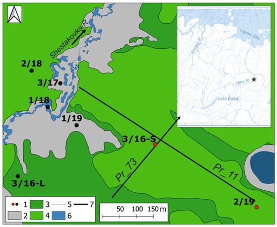
Figure 1.
Scheme of the study site: 1—boreholes, red circles in talik, black circles in permafrost from the surface, 2—moss-grass bogs, 3—larch and birch forest, 4—pine forest, 5—river, 6—water body, 7—GPR profiles.
We used ground penetrating radar (GPR) profiling to define the talik boundaries and thickness at the end of August. The GPR profiles are shown in Figure 1. We used the GPR device “OKO-3” (Logis-GEOTEKH Company, Ramensckoe city, Moscow region, Russia) with antenna units AB-150 and AB-250 with center frequencies of 150 MHz and 250 MHz, respectively. We used the following scanning parameters: sweep 200 ns for AB-250 and 400 ns for AB 150; accumulation of signals-16; recording mode-continuous profiling. The measurements were taken in close contact with the ground without the use of auxiliary wheels. The GPS points are placed at the ends of the profile, as well as every 50 m throughout the profile for accurate binding of GPR profiles to the terrain. Measurement of GPR profiles and data processing was carried out using the software “GeoScan32” (LLC “LogiS”, Russia). For accurate determination of the talik’s thickness, we used data from the boreholes. The depth scale for radargrams (scale on the right), recorded in the autumn, almost at the maximum seasonal thaw layer, is set to the dielectric constant equal to ε = 9.
All of the boreholes were equipped with ground temperature sensors with long cables specifically designed for borehole measurements. Thermistor cables were placed in the boreholes at the depths of 0, 0.5, 1, 1.5, 2, 2.5, 3, 3.5, 4, 4.5, 5, 6, 7, 8, 9 and 10 m (depending on the borehole depth). We the measured groundwater level at several hydrogeological wells with well screen both manually and using Onset Hobo Water Level Data Loggers.
3. Results
3.1. Taliks Structure
On the right-bank terrace of the Left Shestakovka river, a suprapermafrost subaerial aquifer talik 180–200 m wide and more than 900 m long was found. We made several GRP surveys to understand the talik’s thickness and extent. Several boreholes were drilled to verify the geophysical data.
Figure 2 shows two perpendicular profiles Pr_11 and Pr_73. The radargrams are presented on a scale of 1:7 (horizontal to vertical scale).
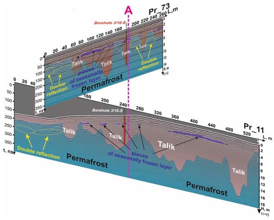
Figure 2.
Pseudo-three-dimensional representation of taliks along two profiles according to GPR data.
Profile Pr_11, 545 m long, was located in a pine forest along the gentle slope towards the river. The seasonally thaw layer (STL) is clearly visible outside of the talik area in the beginning of the profile. Its thickness varies from 2.0–2.6 m, with the average value of 2.4 m. In the larger half of the profiles, the STL and the talik merge into a single unfrozen body in the end of warm season. Four talik areas with a thickness of 3.5–17 m were found in the profile Pr_11 at 105–545 m from the beginning. The boundary below the STL is a double reflection, and is not related to the talik. Most likely, it indicates the absence of thawed layers below.
The perpendicular profile Pr_73 is located across the slope. The STL is also clearly visible in the beginning of the profile. Its thickness is from 2.0 to 2.8 m with an average value of 2.2 m. Five taliks with a thickness of 3–11 m were found along the profile at 60 ÷ 150 m, 175 ÷ 190 m, 210 ÷ 226 m from the beginning of the profile.
There is a continuous talik with varying thickness along the slope (Pr_11, in 105–540 m from the beginning), while separate taliks were found in the profile across the slope (Pr_73). This suggests the existence of several water-conducting talik “channels” along the slope and its patchy distribution across the slope. Several residuals of the seasonally frozen layer above the taliks confirm that, at the end of the summer, the seasonal thaw layer outside the talik and the talik itself form single aquifer.
3.2. Geological Structure
The ground temperature depends on the geological structure of the section, the topography and the landscape. The dominant landscape units in the study site (see Figure 1) are: pine forests that cover gentle slopes; larch forests and moss-grass bogs (hallow patches) in depressions; the river valley, including the floodplain and the riverbed. The absolute elevation varies from 189 m on the floodplain of the Left Shestakovka river to 200–205 m on the hillslopes.
The geology within the same landscape unit is basically similar. Figure 3 shows geological sections of seven boreholes, located in the talik area (3/16-S, 2/19) and in areas with permafrost from the surface. A relatively homogeneous geological structure, both in depth and in space, is typical for areas covered with pine forests. The sediments underlying the moss-grass bogs and the river valley has a more complex geological structure, with interbedded rocks that differ in mechanical composition, ice content and other characteristics.
Figure 3.
Geological sections of seven boreholes, located in talik area (3/16-S, 2/19) and in permafrost from the surface area (all other boreholes).
In areas covered with pine forest, the ground cover is sparse and consists of pine needle litter and patchy thickets of lingonberry and bearberry. The borehole 2/19 was drilled down to a depth of 21 m on a very gentle slope (1–2°) on the right bank of the left Shestakovka river, 640 m from its channel. The geological section is represented by silty to coarse sands (see Figure 3). In the area of borehole 3/16, 300 m from the river floodplain terrace, medium-grained sands with signs of ferruginization and rare inclusions of organic matter were exposed throughout the section to a depth of 10 m.
Boreholes 2/19 and 3/16 encountered an aquifer at depths of 2.5–18.0 and 1.7–6.0, respectively. The gravimetric moisture content (ice content) of the sands in the active layer in April increased down the section from 1.5–2 to 8.3–10%, and directly at the top of the aquifer it amounted to 17.6–20%. Frozen deposits in the permafrost roof (just below the talik) had ice contents from 18.3–19.6 to 33–35%.
All other boreholes penetrated frozen deposits. Borehole 2/18 (15 m deep), drilled on the left bank of the river in a pine forest, intersected fine-grained sands with signs of ferruginization and thin layers of sandy and silty loams.
Borehole 3/16-L in the birch-larch forest, 3.9 m deep, intersected uniform frozen medium-grained sands with organic inclusions. The ice content of the rocks ranged from 16.3 to 22.3%.
The geological structure of the Left Shestakovka river floodplain is described in detail by Tarbeeva et al. [24] based on the drilling of borehole 3/17 with a depth of 21 m. Under the peat litter, fine- and medium-grained sands with interlayers of gravel and peat occur from the surface to a depth of 4.7 m. They are underlain by silty sandy loam with peat interlayers and fine-grained sands with interlayers of plant remains. Silty sandy loams and silty sands occur at the base of the section. The ice content of the deposits was greater in the near-surface peaty horizon (>40%). It varied from 17 to 35% in the depth interval of 1–14 m and decreased to 14–15% at depths of 18 and 20 m.
In the Left Shestakovka riverbed, borehole 1/18 intersected fine- and medium-grained sands with inclusions and thin interlayers of organic matter and peat from the surface to a depth of 4 m. Down to a depth of 4.8 m, they are underlain by silty, sandy and light loams with numerous ice schlieren. In the depth interval of 4.8–10.5 m, the section is represented by silty and fine-grained sands with interlayers of organic matter and signs of ferrugination. Down to a depth of 12 m, they are underlain by silty sandy loams with interlayers of light loams and silty fine-grained sands. The ice content of the deposits varied from 16 to 25.6%, increasing at depths of 0.3–0.5 m (29–49.5%) and 4.0–4.5 m (31–59.4%).
On the moss-grass bog on the right bank of the river, the geological section was studied to a depth of 16 m by drilling borehole 1/19. Here, under a 0.7 m layer of icy peat, ferruginous fine- and medium-grained sands with peat are exposed. They are underlain by medium-grained sands with ferruginous spots and organic inclusions, which are replaced by silty sands from a depth of 4.8 m. At a depth of 5.3 to 8.3 m, fine- and medium-grained sands occur with interlayers of organic matter and ferrugination; in the lower part of the interval, they contain inclusions of loam and ice. Deeper toward the bottom of the borehole, fine-grained silty sands with interlayers of organic matter and ferrugination were exposed.
Drilling revealed subaerial suprapermafrost talik aquifers 5.5–15.5 m thick on the right bank of the river in the pine forests, associated with sandy deposits. In similar landscape conditions, the borehole penetrated frozen deposits only on the left bank of the river. The probable reasons for the absence of a talik here are the more dispersed geology—the presence of fine-grained sands, sandy loams, loams and silty sands in the section—as well as the steepness of the slope, which leads to rapid surface and suprapermafrost subsurface water flow to the river. Outside the pine forests, taliks were not found, regardless of the geology.
3.3. Ground Temperature in Taliks and Beyond
Ground temperature curves for the period May 2019–April 2020 are shown at Figure 4 for six boreholes. The difference in the ground temperatures in the taliks and beyond is clearly seen.
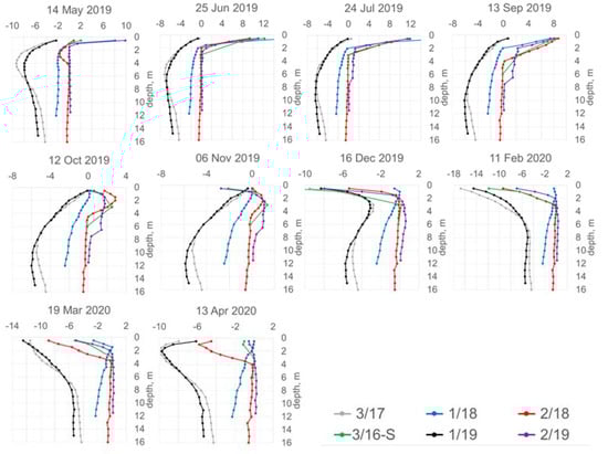
Figure 4.
Ground temperature curves at six boreholes for selected dates during the period May 2019–April 2020, °C.
In the river floodplain (borehole 3/17), moss-grass bogs (borehole 1/19) and larch forest (borehole 3/16-L), the permafrost is cold. In the summer, it thaws up to 1 m only. At this depth, the ground temperature drops up to −11–−18 °C in late winter. Its seasonal fluctuations reach a depth of 15–18 m with a delay of 9–10 months. The thickness of the layer of zero annual amplitudes is approximately 20 m.
Under the freezing narrow river channel (borehole 1/18), ground thawing begins in late May–early April, and it completely freezes in November–December. The AL thickness is 2.5 m. At this depth, the ground temperature varies from 0.0 °C to −4.7 °C. The thickness of the layer of annual heat exchanges is 15 m. Under the beaded parts of the river, where water remains under the river ice in winter, there are taliks up to 8 m thick [24]. The connection between the channel and slope subaerial taliks is apparently absent in the winter season.
In borehole 2/18 on the left bank of the river valley in the pine forest, the seasonal thawing reaches the maximum value among all of the studied sections: 4.5 m. Taking into account the relatively high ground temperature, talik formation is possible here after a humid summer and warm snowy winter.
In the suprapermafrost subaerial talik (boreholes 2/19 and 3/16-S), the thickness of the seasonal freezing layer is 2.0–3.5 m. In the summer, the ground at the bottom of the seasonal freezing layer warmed up to a temperature of 2.1–2.9 °C. In the talik aquifer, the temperature of the rocks varied from 0 °C in the winter to 2.3 °C in autumn. The permafrost underlying the talik has a high negative temperature (−0.1–−0.3 °C). The thickness of the layer of annual heat exchanges is 6–12 m.
In the suprapermafrost subaerial talik, the thickness of the seasonal freezing layer remained relatively stable over time; however, the timing of its formation varied from year to year. Typically, the thawing of the seasonal freezing layer begins in mid-April and reached a depth of 0.5 m in May.
3.4. Groundwater Level in Talik Aquifers
The talik aquifer is oriented along the slope. Groundwater filtrates through the sand pores and down the slope. The elevation at borehole 2/19 is 2.7 m higher in comparison with the ground surface at borehole 3/16-S. The excess of the groundwater surface is even higher—from 3.0 to 3.5 m. The aquifer discharges in a dissipative way on the steep slope of the river terrace. Talik groundwater contributes to the river that is confirmed by the formation of aufeis in the winter on the river terrace slopes. The aufeis reaches 90 m in length and up to 70 cm in thickness.
Figure 5 shows the groundwater level and ground temperatures at three depths for the period from December 2019–October 2020 in the borehole 3/16-S.
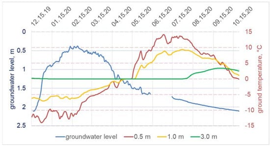
Figure 5.
Groundwater level, m, and ground temperature at three depths, °C, for the period December 2019–October 2020 in the borehole 3/16-S.
The groundwater level in the talik aquifer sharply increases in December and January, when the ground is intensively freezing from the surface. Interestingly, the groundwater level becomes pressurized after the freezing front reaches the depth of the groundwater level. Water freezing in the pores leads to a quick rise in pressure due to the decrease in free pore volume. The pressurized groundwater level reaches a maximum of 0.5–0.0 m under the surface in the middle of February. After that, the groundwater level declines. This coincides with rises in the ground temperature at the depths of 0.5 and 1.0 m. In the first half of May, the ground temperature at these depths reaches 0 °C, and it becomes positive in the second half of May. After that, the groundwater level gradually descends during the summer and autumn until the next freezing cycle. The groundwater level has a weak response to rain events during the warm period. These small peaks in the groundwater level do not violate the general decrease in the summer–autumn.
4. Discussion and Conclusion
The novelty of our study is the evidence of the long-term existence of subaerial aquifer taliks in the cold region of Central Yakutia, with continuous permafrost of 200–400 m thick. Only a few studies have reported such phenomena before [21,22,23]. To the best of our knowledge, we conducted the first relatively long-term measurements, using data loggers, of ground temperature and groundwater level, as well as drilling and geophysical investigations of the subaerial talik extent and structure in the continuous permafrost zone.
The talik occupies a gentle slope covered by sparse pine forest. The talik has a complex structure. Its thickness varies from 3 to 17 m. Geophysical investigation revealed that the talik has a complex contour. The talik has several water-conducting branches along the slope and a patchy distribution across the slope. During the end of summer seasonal thaw, the layer outside the talik and the talik itself form a single aquifer. The deepest talik was found near the small lake surrounded by a moss-grass bog. The talik and the lake have a connection in summer–autumn period. Most probably, the talik aquifer receives water from the lake. Another possible water source is the intensive rainfalls that usually occur once in every two–three years.
We revealed several unique features of the ground temperature and groundwater level seasonal dynamics in the talik areas in comparison with the surrounding permafrost landscapes.
The lowest ground temperature, a shallow thickness of the seasonal thaw layer (about 1 m) and a deep penetration of seasonal temperature fluctuations (>15 m) were found on the floodplain and on the moss-grass bog. In the larch forest, the ground temperature is higher than in the moss-grass bog and on the floodplain of the river. The low ground temperatures in these landscapes are explained by the presence of a wet organic layer. Its thermal conductivity is higher in the winter than in the summer. The thickness of ice-rich peat was 0.75 m on the moss-grass bog and 0.32 m on the floodplain; in the larch forest, the thickness of the continuous moss cover is up to 0.3 m.
The highest ground temperature is revealed on the gentle slopes covered with sparse pine forest with almost no ground cover. The active layer thickness reaches 4.5 m, and the depth of zero annual amplitudes is 5–12 m. Sandy deposits almost exclusively represent the geological section here. Two boreholes intersected talik aquifers. Apparently, the ground warming in the pine forests is associated both with the absence of an organic layer on the surface and with the filtration of the suprapermafrost groundwater of the active layer and taliks in sandy deposits. The water-saturated deposits in the talik have a temperature of about 0 °C throughout the year and do not freeze because of the constant filtration of water through the pores and convective heat transfer.
The riverbed has an intermediate position between the “warm” and “cold” areas. The active layer thickness here is 2.5 m, and the depth of zero annual amplitudes is about 15 m. The river’s streamflow from May to October and the absence of an organic horizon contribute to the preservation of higher temperatures in this section compared to the areas on the moss-grass bog and on the floodplain. However, loams and sandy loams in this section limit groundwater filtration, convective heat transfer and the formation of the permanently thawed horizons.
Although the talik groundwater level is relatively close to the land surface, at a depth of just 1–3 m, it has very weak response to snowmelt and precipitation events. The talik groundwater shifts from the phreatic to the artesian type during the year. The maximum groundwater level occurs in February under the cryogenic pressure due to deep ground freezing above the talik aquifer. The aufeises in the lower part of the talik’s slopes confirm its discharge into the Left Shestakovka River.
Complicated relations between the landscape and the groundwater in the given geological conditions lead to the long-term existence of talik aquifers in the continuous permafrost environment. The talik genesis, distribution, long-term dynamics, contribution to river streamflow and possible role in permafrost degradation are still open research questions.
Author Contributions
Conceptualization, L.L.; methodology, L.L. and N.P.; investigation, L.L. and I.K.; writing—original draft preparation, L.L.; writing—review and editing, N.P.; visualization, L.L. and I.K. All authors have read and agreed to the published version of the manuscript.
Funding
This research was funded by Russian Science Foundation and Yakutian Science Foundation, grant number 22-17-20040.
Acknowledgments
We are grateful to V.S. Efremov, V.V. Ogonerov, N.E. Baishev and K.P. Danilov for their valuable contribution to the fieldwork.
Conflicts of Interest
The authors declare no conflict of interest.
References
- O’Neill, H.B.; Roy-Léveillée, P.; Lebedeva, L.; Ling, F. Recent advances (2010–2019) in the study of taliks. Permafr. Periglac. Process. 2020, 31, 346–357. [Google Scholar] [CrossRef]
- Devoie, E.G.; Craig, J.R.; Connon, R.F.; Quinton, W.L. Taliks: A tipping point in discontinuous permafrost degradation in peatlands. Water Resour. Res. 2019, 55, 9838–9857. [Google Scholar] [CrossRef]
- Report on the Special Features of Climate on the Territory of the Russian Federation in 2020; Roshydromet: Moscow, Russia, 2021; 104p.
- Biskaborn, B.K.; Smith, S.L.; Noetzli, J.; Matthes, H.; Vieira, G.; Streletskiy, D.A.; Schoeneich, P.; Romanovsky, V.E.; Lewkowicz, A.G.; Abramov, A.; et al. Permafrost is warming at a global scale. Nat. Commun. 2019, 10, 264. [Google Scholar] [CrossRef]
- Wang, L.; Zhao, L.; Zhou, H.; Liu, S.; Hu, G.; Li, Z.; Wang, C.; Zhao, J. Evidence of ground ice melting detected by InSAR and in situ monitoring over permafrost terrain on the Qinghai-Xizang (Tibet) Plateau. Permafr. Periglac. Process. 2022, 1–16. [Google Scholar] [CrossRef]
- Farquharson, L.M.; Romanovsky, V.E.; Cable, W.L.; Walker, D.A.; Kokelj, S.V.; Nicolsky, D. Climate change drives widespread and rapid thermokarst development in very cold permafrost in the Canadian High Arctic. Geophys. Res. Lett. 2019, 46, 6681–6689. [Google Scholar] [CrossRef]
- Liu, W.; Xie, C.; Zhao, L.; Li, R.; Liu, G.; Wang, W.; Liu, H.; Wu, T.; Yang, G.; Zhang, Y.; et al. Rapid expansion of lakes in the endorheic basin on the Qinghai-Tibet Plateau since 2000 and its potential drivers. Catena 2021, 197, 104942. [Google Scholar] [CrossRef]
- Farquharson, L.M.; Romanovsky, V.E.; Kholodov, A.; Nicolsky, D. Sub-aerial talik formation observed across the discontinuous per-mafrost zone of Alaska. Nat. Geosci. 2022, 15, 475–481. [Google Scholar] [CrossRef]
- Ward Jones, M.K.; Pollard, W.H.; Jones, B.M. Rapid initialization of retrogressive thaw slumps in the Canadian High Arctic and their response to climate and terrain factors. Environ. Res. Lett. 2019, 14, 055006. [Google Scholar] [CrossRef]
- Schneider von Deimling, T.; Lee, H.; Ingeman-Nielsen, T.; Westermann, S.; Romanovsky, V.; Lamoureux, S.; Walker, D.A.; Chadburn, S.; Trochim, E.; Cai, L.; et al. Consequences of permafrost degradation for Arctic infrastructure—Bridging the model gap between regional and engineering scales. Cryosphere 2021, 15, 2451–2471. [Google Scholar] [CrossRef]
- Romanovsky, V.E.; Smith, S.L.; Christiansen, H.H. Permafrost thermal state in the Polar Northern Hemisphere during the international polar year 2007–2009: A synthesis. Permafrost Periglac. Process. 2010, 21, 106–116. [Google Scholar] [CrossRef]
- Briggs, M.A.; Walvoord, M.A.; McKenzie, J.M.; Voss, C.L.; Day-Lewis, F.D.; Lane, J.W. New permafrost is forming around shrinking arctic lakes, but will it last? Geophys. Res. Lett. 2014, 41, 1585–1592. [Google Scholar] [CrossRef]
- Drozdov, D.S.; Ukraintseva, N.G.; Tsarev, A.M.; Chekrygina, S.N. Change of permafrost temperature field and geosystem state on the Urengoy oil-gas-field territory during the last 35 years (1974–2008). Kriosfera zemli [Earth’s Cryosphere] 2010, 14, 22–31. [Google Scholar]
- Malkova, G.V.; Pavlov, A.V.; Skachkov, Y.B. Assessment of resilience of frozen deposits under modern changes of climate. Kriosfera zemli [Earth’s Cryosphere] 2011, 15, 33–36. [Google Scholar]
- James, S.R.; Minsley, B.J.; McFarland, J.W.; Euskirchen, E.S.; Edgar, C.W.; Waldrop, M.P. The biophysical role of water and ice within permafrost nearing collapse: Insights from novel geophysical observations. JGR Earth Surf. 2021, 126, e2021JF006104. [Google Scholar] [CrossRef]
- Hiyama, T.; Asai, K.; Kolesnikov, A.B.; Gagarin, L.A. Estimation of the residence time of permafrost groundwater in the middle of the Lena River basin, eastern Siberia. Environ. Res. Lett. 2013, 8, 035040. [Google Scholar] [CrossRef]
- Lamontagne-Hallé, P.; McKenzie, J.M.; Kurylyk, B.L.; Zipper, S.C. Changing groundwater discharge dynamics in permafrost regions. Environ. Res. Lett. 2018, 13, 084017. [Google Scholar] [CrossRef]
- Douglas, T.A.; Hiemstra, C.A.; Anderson, J.E.; Barbato, R.A.; Bjella, K.L.; Deeb, E.J.; Gelvin, A.B.; Nelsen, P.E.; Newman, S.D.; Saari, S.P.; et al. Recent degradation of interior Alaska permafrost mapped with ground surveys, geophysics, deep drilling, and repeat airborne lidar. Cryosphere 2021, 15, 3555–3575. [Google Scholar] [CrossRef]
- Connon, R.; Devoie, É.; Hayashi, M.; Veness, T.; Quinton, W. The influence of shallow taliks on permafrost thaw and active layer dynamics in subarctic Canada. JGR Earth Surface 2018, 123, 281–297. [Google Scholar] [CrossRef]
- Varlamov, S.P.; Skachkov, Y.B.; Skryabin, P.N. Influence of Climate Change on the Thermal Condition of Yakutia’s Permafrost Landscapes (Chabyda Station). Land 2020, 9, 132. [Google Scholar] [CrossRef]
- Lebedeva, L.S.; Bazhin, K.I.; Khristoforov, I.I.; Abramov, A.A.; Pavlova, N.A.; Efremov, V.S.; Ogonerov, V.V.; Tarbeeva, A.M.; Fedorov, M.P.; Nesterova, N.V.; et al. Suprapermafrost subaerial taliks, Central Yakutia, Shestakovka river basin. Kriosfera Zemli [Earth’s Cryosphere] 2019, 23, 40–50. (In Russian) [Google Scholar]
- Ponomareva, O.E. Aquiferous taliks in sandy sediments on the lower reaches of the Vilyui river. Kriosfera Zemli [Earth’s Cryosphere] 1999, 3, 84–89. (In Russian) [Google Scholar]
- Boitsov, A.V. Conditions of formation and the regime of slope taliks in Central Yakutia. In Hydrogeological Studies; MPI SB RAS: Yakutsk, Russia, 1985; pp. 44–55. (In Russian) [Google Scholar]
- Tarbeeva, A.M.; Lebedeva, L.S.; Efremov, V.S.; Krylenko, I.V.; Surkov, V.V.; Shamov, V.V.; Lutsenko, T.N. Conditions and processes of formation of a beaded channel of a small river in permafrost, Shestakovka River, Central Yakutia. Kriosfera Zemli [Earth’s Cryosphere] 2019, 23, 38–48. (In Russian) [Google Scholar]
Disclaimer/Publisher’s Note: The statements, opinions and data contained in all publications are solely those of the individual author(s) and contributor(s) and not of MDPI and/or the editor(s). MDPI and/or the editor(s) disclaim responsibility for any injury to people or property resulting from any ideas, methods, instructions or products referred to in the content. |
© 2022 by the authors. Licensee MDPI, Basel, Switzerland. This article is an open access article distributed under the terms and conditions of the Creative Commons Attribution (CC BY) license (https://creativecommons.org/licenses/by/4.0/).