Abstract
China’s rural areas face population loss and expanded residential land in the context of rapid urbanization. The increasing hollowing of villages leads to extensive land use, making it necessary to optimize and consolidate rural settlements immediately. Therefore, how to choose an appropriate development model for rural settlements is at issue. This article builds a theoretical development model for rural settlements based on their primary development conditions and spatial patterns. It determines the development model according to the classification matrix formed by interweaving different elements in each dimension. Finally, it demonstrates the model through a case study on Pingyin County, China. The empirical findings for Pingyin County are as follows. (1) The scale of rural settlements increased from 2010 to 2020, and the agglomeration and spatial correlation intensified, but they tended to be irregular. (2) The various elements of the development foundation showed apparent spatial differentiation, and the spatial distribution of rural settlements at different levels presented a core–edge structure. (3) The development of rural settlements was reduced to six models: in-situ urbanization, satellite urbanization, competitive-industry-driven, characteristic-tourism-driven, modern-agriculture-driven, and village relocation. Finally, the article proposes different development paths for different development models.
1. Introduction
Since its reform and opening up 40 years ago, China, the world’s largest developing country and a country with a large rural population, has experienced a rapid transition from a planned economy to a market economy [1]. Driven by rapid economic growth and urbanization, a large number of rural people, especially young and middle-aged laborers, have poured into cities [2]. By the end of 2021, China’s urbanization rate reached 64.72%, which means that less than 40% of the population lives in rural areas. With the flow of population from rural areas to cities, rural areas are gradually facing economic recession, population aging, and labor shortages, that is, rural shrinkage [3]. Interestingly, in contrast to the shrinkage in population, the land used for rural settlements tends to expand slowly, despite the population loss. The reason behind this is that rural residents accumulate wealth by dividing up family property, living apart, and expanding their homesteads. Continuous and rapid urbanization leads to a reduction in the rural population and the expansion of rural residential land [4], resulting in “hollowed villages”, weakened development vitality, scattered rural settlements, and inefficient land use [5]. Taken together, these factors have resulted in the contradiction between rural shrinkage and land expansion becoming increasingly prominent, seriously restricting the sustainable development of rural areas [6]. At the same time, influenced by China’s unique urban–rural land system and its household registration system, the evolutionary trajectories of rural land use types differ from those of other countries in scale and speed [7]. Coupled with the lack of systematic planning and supervision, as well as the traditional concept of free site selection and settlement, problems such as scattered layout and inefficient land use have arisen in the construction and development of China’s rural settlements.
The form and the spatial distribution pattern of rural settlements, where rural residents’ production and lives, constitute and reflect the regional system of the human–land relationship [8]. Rural settlements have always been the focus of planning, sociology, and geography. Scholars have carried out extensive research on the identification and evaluation, spatiotemporal evolution and influential factors, and layout optimization of rural settlements. Firstly, the accurate identification of rural settlements lays the foundation for related research. At present, rural settlements are mainly extracted through remote sensing images. Machine learning techniques [9], the edge-suppressed points voting method [10], GIS-defined buffer zones combined with census data [11], added auxiliary variables [12], and integration of remote sensing and GIS analyses [13] are used to improve the identification accuracy. On this basis, the minimum cumulative resistance model and indicator system are employed to evaluate the suitability or function of rural settlements [14,15]. Secondly, by measuring the layout characteristics of rural settlements based on landscape structure, spatial proximity structure, the internal structure of houses, social structure, etc. [16], it is found that the idle land rate is higher in rural settlements than in metropolitan suburbs and cities [17]. The transformation of land use structure shows that the expansion of rural settlements is mainly based on the occupation of cultivated land, but it is difficult to reclaim cultivated land from rural settlements [18]. There are differences in the expansion of rural settlements in different regions, which are manifested not only in the three major geographical zones [19] but also in different landforms. The land use structure of rural settlements in mountainous areas changes slowly, while the spatial structure in plains and semi-mountainous areas changes remarkably rapidly [20]. Researchers have attempted to divide the development stages [21], summarize the development model [22], and explore development law according to the transformation characteristics of rural settlements. In terms of influential factors, the natural environment has a significant impact on rural settlements in mountainous areas [23], but with the improvement of infrastructure, the impact of socio-economic foundations has gradually become prominent. Thirdly, the optimization of the spatial layout of rural settlements is an efficient means of improving the intensive use of rural land and promoting the governance of national land space [24], and this is where the practical significance of related research lies. Scholars have tried to divide the types of optimization used for residential areas and to optimize the layout of rural settlements [25,26] based on location conditions, the ecological environment, and regional development planning. Generally speaking, relevant theoretical and empirical studies are productive but they mainly focus on the layout characteristics and spatiotemporal evolution of rural settlements. The development model of rural settlements at a fine scale remains under-researched.
To alleviate the contradiction between rural shrinkage and the expansion of rural settlements, China began to explore how to optimize rural settlements in the 1980s. With the promulgation of The Implementation Opinions on Further Promoting the Construction of Rural Communities in 2015, a wave of village merging was once again initiated. However, due to the “one size fits all” approach during the implementation, which prejudiced the interests of farmers, it was called to a halt. Addressing the contradiction between population loss and land expansion accompanied by rural shrinkage, optimizing rural settlements with extensive land use, and seeking a development model that conforms to the reality of the village are major issues that China’s rural areas will face for a long time to come. The present study focuses on the contradiction between rural shrinkage and the expansion of rural settlements, constructs a theoretical model to determine a development model for rural settlements, and verifies the rationality and operability of the model. In so doing, it aims to improve the efficiency of rural land use and drive China’s rural revitalization strategy and high-quality development in rural areas.
2. Research Methods and Area
2.1. Rural Population and Land Use at Different Urbanization Stages
The population is a highly mobile element in a region. Its movement from rural to urban areas is the driving force of urbanization as well as the main cause of rural shrinkage. On the one hand, the rural population’s transfer to cities and the concentration of people in cities promote urbanization, and the urbanization of the rural population has become an inevitable product in this process. On the other hand, rural population loss is the primary factor accounting for, and the most direct manifestation of, rural shrinkage. In the process of urbanization, urban and rural elements permeate each other. In particular, considerable numbers of people flow from rural areas to cities [2], resulting in a serious loss of rural population, especially young and middle-aged labor [27], and the phenomenon of rural shrinkage. In addition, vacant buildings, an aging population, and the hollowing out of villages manifested by rural shrinkage further diminish the attractiveness of the area, which in turn exacerbates the loss of rural population. The process of unstoppable urbanization globally is accompanied by rural shrinkage featuring rural population loss. As such, rural shrinkage can be considered a phenomenon accompanying urbanization.
Therefore, to clarify the relationship between the rural population and residential land use in the context of rural shrinkage, it is necessary to analyze the population flow patterns at different urbanization stages, i.e., the direction and scale of population flow between urban and rural areas. In the early stage of urbanization (Figure 1), the population is concentrated in rural areas. Owing to the loose environment for homestead management, approval, and transactions and the lack of village construction planning, rural residents rely on grass-roots administrators and they purchase and construct houses in large numbers, resulting in the continuous growth of rural residential land [28]. In the middle stage of urbanization, as the level of urbanization increases rapidly, a huge rural population, especially young and middle-aged laborers, migrates to cities, and the area of rural residential land continues to expand [29]. There is a strong negative decoupling between the rural population and residential land [30]. Meanwhile, the current household registration system reduces the willingness of farmers to withdraw from their homesteads [31], leading to the phenomenon of “people leaving while houses are remaining”, which leads to vacant and abandoned homesteads. As a result, problems such as rural hollowing, one household with multiple houses, rural population outflow, and residential land expansion arise. A too-large residential land area per capita seriously wastes land resources.
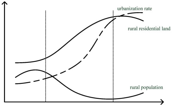
Figure 1.
Rural population and land use at different urbanization stages.
As the urban–rural gap continues to narrow and the urban–rural dichotomy gradually breaks up, driven by rural development policies, some urban capital, talents, and technologies gradually flow into the countryside, and industries such as tourism, health care, and elderly care attract the urban middle class to the countryside. This phenomenon first appeared in European and American countries and the eastern part of China [32] and is similar to rural gentrification [33]. However, this phenomenon is not yet counterurbanization in China [34]; rather, it can be regarded as the result of rural eco-health tourism. This “reverse flow” of the population from cities to rural areas directly or indirectly promotes the reconstruction of rural material landscapes, industrial structures, and social structures [35]. The previously dilapidated rural homesteads are re-planned and integrated into new residential land, and some residential land is reclaimed as cultivated land. The amount of rural residential land per capita decreases, and the scale of rural residential land becomes in balance with the population.
2.2. Research Methods
2.2.1. Modeling Framework
Currently, China is in the mid-term acceleration stage of urbanization and is about to enter the later mature stage. At this stage, the population flows from rural areas to cities more quickly. While the rural population continues to decrease, the change in rural residential land use lags behind the change in the rural population, hence the phenomena of “fewer people with more land”, hollowed villages, idle land, and population aging. There are many contradictions between the expansion of urban land and the vacancies and waste in rural construction land, and the intensive use of rural land is required immediately. To solve these problems, it is necessary to differentiate between and optimize rural settlements. Therefore, we attempt to build a model to explore the development models for rural settlements, as shown in Figure 2. This model fully considers the realities of rural population loss, expansion of rural residential land, and urban land expansion and focuses on development problems such as rural shrinkage, lack of vitality in rural development, and the serious waste of rural residential land. It illuminates the development merits and demerits and the spatial patterns of different rural settlements through systematic analysis, thereby dividing the development models and determining the development direction.
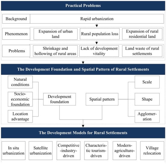
Figure 2.
The framework of the theoretical development model for rural settlements.
The development foundations of rural settlements include natural conditions, socio-economic foundations, and location advantages. Natural conditions affect the distribution of population and industries, especially in areas dominated by mountains and hills. It is not only the basis for the formation of rural settlements but also a prerequisite for their adjustment and optimization [36]. Socio-economic foundations form the driving force for the development of rural settlements. Sound economic conditions can improve the living standards of residents and promote the coordinated development of urban and rural areas. The location advantage determines the degree of radiation to rural settlements of urban public service facilities and traffic lines. The spatial pattern of rural settlements includes three aspects: scale, shape, and agglomeration. The scale reflects the land area of a single or many rural settlement patches, the shape represents the regularity and fractal characteristics of the rural settlement patches, and the agglomeration stands for the spatial correlation and agglomeration of the overall distribution of rural settlements.
2.2.2. Evaluation Model for the Development Foundation of Rural Settlements
(1) Modeling
The formation and the development of rural settlements are subject to specific natural and humanistic environments. Therefore, we built a model to evaluate the development foundation of rural settlements based on natural conditions, socio-economic foundations, and location advantages (Table 1). Natural conditions are external factors affecting the layout and development of rural settlements, and they play a fundamental role in the siting, resource allocation, and path selection of rural settlements [37]. Here, we selected five indicators to measure natural conditions: elevation, slope, aspect, vegetation coverage, and susceptibility to geological disasters. The layout of rural settlements at suitable elevations, slopes, and aspects is conducive to the concentrated development of villagers’ production and lives and the large-scale construction of infrastructure [38]. The higher the vegetation coverage, the better the ecological environment, which means that it is not suitable for large-scale production activities. It can be characterized by the normalized difference vegetation index (NDVI). Rural settlements should be far away from areas with frequent geological disasters, especially mountainous environments with frequent geological disasters [39]. The susceptibility to geological disasters is represented by the distance from the rural settlements of the hidden danger points of geological disasters.

Table 1.
The comprehensive evaluation indicator system for the development foundation of rural settlements.
To a certain extent, the evolution in rural populations and land use reflects the requirements of socio-economic development [40]. For this reason, the socio-economic foundations also serve as an important basis for the selection of development models for rural settlements. In this paper, we used six indicators to represent the socio-economic foundations: population density, night-time economic vitality, road network density, grain output, enterprise density, and the density of life service industries. The population is the subject of economic activities and the basic resource for rural economic development, and the density represents the population aggregation of rural settlements. Night-time economic vitality is the performance of economic development [41], which is characterized by the night-time light index. Road network density represents the support and guarantees to rural settlements of the traffic foundation. Food security is the basis of rural revitalization, and the grain output reflects the level of agricultural development and guarantees food security. The densities of enterprises and life service industries represent the concentration of various economic entities [42]. In particular, the density of life service industries mainly includes shopping, accommodation, and catering services.
The location advantage indicates the spatial link between rural settlements and other factors [43] and was measured by six indicators in the present study: the distance from the county seat, the distance from a national highway, educational accessibility, medical accessibility, the distance from a river, and the distance from cultivated land. According to the distance decay theory, the closer they are to an urban area, the easier it is for rural settlements to accept its radiation [44]. The layout of rural settlements and the aggregation of production factors are oriented toward traffic arteries [45], and a national highway is an important medium for the economic connection between the regional population and the outside world and is the main prerequisite for promoting socio-economic development. The distance from a national highway directly affects the external accessibility of rural settlements. The higher the accessibility of education and medical care, the better the enjoyment of high-quality educational and medical resources [26]. A river not only provides the rural residents with the necessary water for production and living but also provides a beautiful natural landscape. The distance from cultivated land is based on the needs of residents for agricultural production activities [46].
(2) Calculation
To avoid the influence of subjective factors, the entropy method was used to determine the weights of the standardized indicators [47] in the evaluation model for the development foundation of rural settlements, and then the criterion layer and the total score RD were obtained by weighted calculation. In the standardization process, the elevation, slope, vegetation coverage, susceptibility to geological disasters in natural conditions, and the location advantage were negative indicators, while the rest were positive indicators. The normalization equations for positive and negative indicators are:
First, the proportion of the ith rural settlement with respect to the jth indicator (pij) was calculated:
The entropy (ej) of the jth indicator was calculated, and the coefficient of difference (gj) of the jth indicator was also calculated:
Then, the weight (wj) of the jth indicator was obtained:
Finally, the total score (RD) of the evaluation model for the development foundation of rural settlements was calculated: .
2.2.3. The Spatial Pattern of Rural Settlements
Rural settlements in the agricultural landscape are mainly manifested as patches of different sizes, areas, and arrangements [28]. The geographic differentiation and pattern evolution of the location, scale, shape, and structure of these patches can reveal the footprints of human–land interactions at different stages and in different regions and can also serve as an important basis for rural settlements to determine their development model. In the present study, the spatial pattern of rural settlements was described by methods such as landscape metrics and kernel density estimation.
(1) Landscape Metrics
The term landscape metric refers to a simple quantitative indicator that can highly condense landscape information and reflect some aspects such as its structural composition and spatial configuration [48]. Referring to previous studies [49,50], the number of patches (NP), total (class) area (CA), mean patch size (MPS), patch density (PD), and the largest patch index (LPI) were used to reflect the scale of rural settlements using Fragstats. The landscape shape index (LSI), mean perimeter-to-area ratio (PARA_MN), and mean fractal dimension index (FRAC_MN) were employed to reflect the shape of rural settlements. The Euclidean nearest-neighbor distance (ENN_MN) and aggregation index (AI) were adopted to reflect the agglomeration of rural settlements. The specific equations and definitions are shown in Table 2.
Table 2.
The equations and definitions of landscape metrics.
(2) Kernel Density Estimation
Kernel density estimation, which directly reflects the spatial density of measured values in a continuous area [51], was used to represent the agglomeration of rural settlements. A circle was generated by taking all the rural settlement patches in the area as the center and setting an appropriate radius. The closer the distance to the center of the circle, the greater the raster density and the higher the distribution density of rural settlements. If no settlements fall into the raster dataset, the density value is zero. The calculation equation is:
where f(x) is the estimated kernel density; k(x) represents the kernel density function; T refers to the number of rural settlement patches; h stands for the bandwidth, that is, the distance attenuation threshold; and (x − Xi) reflects the distance between Xi and sample point x. The greater the estimated kernel density, the denser the distribution of rural settlements.
2.2.4. Classification Matrix of Rural Settlement Development Models
To determine the development model for rural settlements, it is crucial to take the development foundation and spatial pattern into consideration. A “coordinate system“ to determine the development model for rural settlements was constructed, taking the development foundation as the horizontal axis and the spatial pattern as the vertical axis, as shown in Figure 3. The horizontal and vertical axes each contain three different elements, expressed as “A, B, and C” and “a, b, and c”, respectively, thereby forming a “3 × 3 grid”, with each location corresponding to the intersection of the different elements of the development foundation and spatial pattern. Each location contains four “quadrants”, which represent the matching of the two elements. On this basis, a two-step process was adopted to determine the development model for rural settlements. To highlight the development advantages and characteristics of rural settlements, the first step was to focus on certain elements in the horizontal and vertical axes, that is, specific locations in the 3 × 3 grid, in order to determine the development orientation of rural settlements. For example, “Aa” means that the development model for the rural settlements relies on natural conditions and scale. In the second step, the development was determined according to the two specific elements of rural settlements in different quadrants in the 3 × 3 grid. For instance, the first quadrant of “Aa” (“Aa1”) represents rural settlements with superior natural conditions and a large scale.
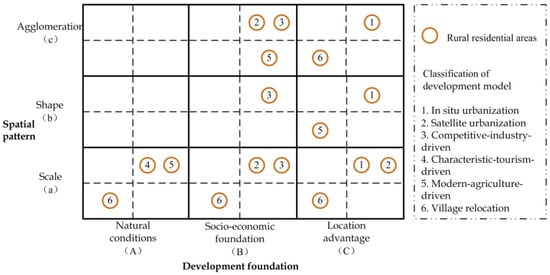
Figure 3.
The basis for the classification of development models of rural settlements.
In total, six development models for rural settlements were identified: in situ urbanization, satellite urbanization, competitive-industry-driven, characteristic-tourism-driven, modern-agriculture-driven, and village relocation. Rural settlements featuring in situ urbanization (Ca1, Cb1, Cc1) are concentrated near an urban area and have close population and economic ties with the urban area; therefore, we focused on location advantages and spatial patterns and selected those rural settlements with superior locations, large scale, regular shape, and strong agglomeration. Satellite towns (Ba1, Bc1, Ca1) have the best economic conditions and larger scale, and their location conditions are second only to those featuring in situ urbanization; therefore, we paid attention to economic foundation and scales, economic foundation and agglomeration, and location advantages and scales and selected the rural settlements with a developed economy, larger scales, strong agglomeration, and superior locations. Rural settlements driven by competitive industries (Ba1, Bb1, Bc1) have a good foundation for industrial development and economic competitiveness; therefore, we attached importance to the economic foundation and spatial pattern and selected those with a developed economy, larger scales, regular shapes, and strong agglomeration. Rural settlements driven by characteristic tourism (Aa1) boast characteristic tourism resources and a beautiful natural environment; therefore, we focused on natural conditions and scales and selected rural settlements with superior natural conditions and larger scales. Rural settlements driven by modern agriculture (Aa1, Bc4, Cb3) have a certain foundation for agricultural development; therefore, we paid attention to natural conditions and scales, economic conditions and agglomeration, and location advantages and shapes and selected those rural settlements with superior natural conditions, large scales, sound economy but poor agglomeration, slightly poor locations, and irregular shapes. Rural settlements formed by village relocation (Aa3, Ba3, Ca3, Cc3) are small, lag behind in economic development, and are located at the edge of the region; therefore, we attached importance to scales and development foundations, agglomeration, and location advantages and selected small-scale rural settlements with poor natural conditions, weak economic foundations, disadvantageous locations, and poor agglomeration.
2.3. Research Area and Data Source
Pingyin County is located in the southeast under the administration of Jinan, the capital of Shandong province (Figure 4). It is a typical county seat surrounding a metropolis, with agriculture as its dominant industry, and is characterized by great urbanization potential and a large number of rural settlements. However, under the siphonic effect of the metropolis, its population tends to shrink. This county is divided into two subdistricts (Yushan and Jinshui) and six towns (Dong’e, Xiaozhi, Kongcun, Hongfanchi, Meigui, and Ancheng), with a total of 351 administrative villages with an area of 827 square kilometers. The county is dominated by hills and plains with high terrain in the south, low terrain in the north and uplift in the middle. In 2020, the county’s GDP was CNY 23.330 billion; the primary, secondary, and tertiary industry ratio was 14.7:55.9:29.4; the fiscal revenue was CNY 4815.69 million; and the per capita disposable income of rural residents was CNY 16,929. Machinery and equipment, medicine and food, green building materials, and carbon electrodes are its traditional competitive industries. Its agricultural development is primarily characterized by roses, vegetables, and animal husbandry. Since the beginning of this century, the total population of Pingyin County has been declining. Between 2000 and 2020, the county lost 21,300 people. At the same time, due to the dual effects of urbanization and rural shrinkage, the lost rural population reached 124,500. In contrast, the area of rural settlements in Pingyin County showed an upward trend, expanding from 67.63 km2 in 2000 to 79.76 km2 in 2020, chiefly by occupying cultivated land (area reduced by 10.63 km2). As a strong modern agricultural county in the province and even the whole country, Pingyin County is expected to develop characteristic agriculture and protect cultivated land resources. Therefore, Pingyin County is a typical example featuring the interesting contradiction between rural population loss and residential land expansion. For this reason, we took this county as a research case, explored its development model based on the development foundation and spatial pattern of its rural settlements, and verified the rationality and operability of the theoretical model.
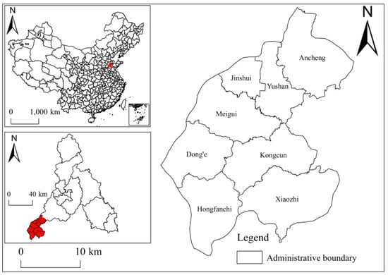
Figure 4.
The administrative division of Pingyin County.
The land use data were obtained from the Data Center for Resources and Environmental Sciences of the Chinese Academy of Sciences, with a spatial resolution of 30 m, and ArcGIS was used to extract the land for rural settlements. Therefore, the rural settlements mentioned herein are not villages or towns in the administrative sense but a collection of rural settlements with an area greater than 30 m × 30 m [52]. The digital elevation model (DEM) data were obtained from the Geospatial Data Cloud website with a spatial resolution of 30 m, and ArcGIS was used to extract and calculate the elevation, slope, and aspect. The aspects of “north, northeast/northwest, east/west, southeast/southwest, and flatland/south” were denoted “1, 2, 3, 4, and 5”, respectively. The NDVI data were also obtained from the Geospatial Data Cloud website. The location data of the hidden danger points of geological disasters were obtained from the official website of Jinan Bureau of Natural Resources and Planning. The point of interest (POI) data were obtained from Baidu Map, and the road and water system raster data were from OpenStreetMap, the NPP-VIIRS night-time light data were from the US National Oceanic and Atmospheric Administration’s data platform, and the population density data were obtained from WorldPop, with a spatial resolution of 100 m. The indicators of location advantages were obtained through ArcGIS. Other socio-economic data were derived from the Statistical Yearbook of Pingyin County and the Statistical Bulletin.
3. Results
3.1. The Spatial Pattern of Rural Settlements in Pingyin County
3.1.1. Scale
The distribution of rural settlement patches of different scales presented a core–edge structure (Figure 5). Large patches were generally distributed in the administrative centers of each town (subdistrict), mainly because the settlements where the town government is located have good location conditions and economic foundations, which appeal to residents. Small settlement patches were distributed at the edge. Judging from the scale of rural settlements in each town (subdistrict), Xiaozhi Town had the largest area and the largest number of patches, while Yushan Subdistrict and Jinshui Subdistrict in the urban area had the smallest areas and the lowest numbers of patches. The MPS of Jinshui Subdistrict was the largest, but the patch density was low, and the spatial distribution of rural settlements was dominated by large patches. Kongcun Town showed the largest patch size and the highest patch density, and rural settlements in the administrative center enjoyed a high primacy. From 2010 to 2020, the number of rural settlement patches in Pingyin County increased from 251 to 262, where Dong’e Town and Kongcun Town each increased by 4, Ancheng Town increased by 2, and Meigui Town increased by 1. The new rural settlements were mainly distributed at the edge and transformed from other land types. They were scattered in points or small agglomerations. The patch size and MPS increased from 75.71 km2 and 301,623 m2 to 79.76 km2 and 304,412 m2. The increased area was mainly concentrated in the settlements where the government offices of Dong’e Town, Kongcun Town, and Ancheng Town were located and at the junction of Meigui Town and Yushan Subdistrict. Among these, Ancheng witnessed the largest increase. Based on the land transition matrix, it was found that the expansion of rural settlements was mainly through encroachment onto cultivated land, and the transfer of cultivated land to rural settlements in these ten years was 9.45 km2. The number of rural settlement patches in Yushan Subdistrict in the urban area did not change, but the land area decreased slightly, which was related to the advancement of urbanization and the increase in demand for urban construction land.
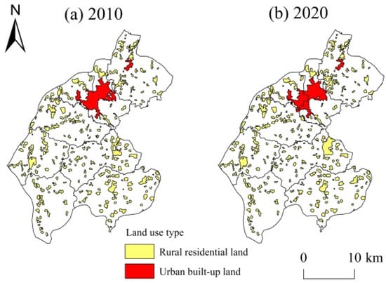
Figure 5.
The distribution of rural residential land in Pingyin County from 2010 to 2020. (a) 2010; (b) 2020.
3.1.2. Shape
In terms of the shape of rural settlements (Table 3), Ancheng Town, with the largest NP, showed the largest LPI and the most irregular patch shape, while Yushan Subdistrict had the smallest LPI and the most regular shape. From 2010 to 2020, the overall LPI and the PARA_MN of rural settlements in Pingyin County exhibited an upward trend, indicating that the shape tended to become irregular while the area increased. In contrast, the LPI of Xiaozhi Town, Hongfanchi Town, and Kongcun Town fell slightly, and the patch tended to be regular. The FRAC_MN generally ranges from 1 to 2. If the value is 1, it means that the shape is the simple and regular; the closer the value is to 2, the more fractal the shape. The FRAC_MN of rural settlements in Pingyin County was very close to 1, and its change during the study period was insignificant, indicating that human factors had a great impact on rural settlements and that their shapes were relatively regular.
Table 3.
The landscape metrics of rural settlements in Pingyin County from between 2010–2020.
3.1.3. Aggregation
Except for the lower kernel densities of Yushan Subdistrict and Jinshui Subdistrict in the urban area, the kernel density of other towns was uniformly distributed (Figure 6). Each town had its own high-density area of rural settlements in its administrative center, and the kernel density of small settlements scattered around the edge was low. From 2010 to 2020, the kernel density showed an upward trend, which validated the above conclusion that the number and areas of settlement patches increased. However, the overall distribution pattern did not see significant change, suggesting that rural settlements expanded based on the original village foundation without changing the overall spatial layout.
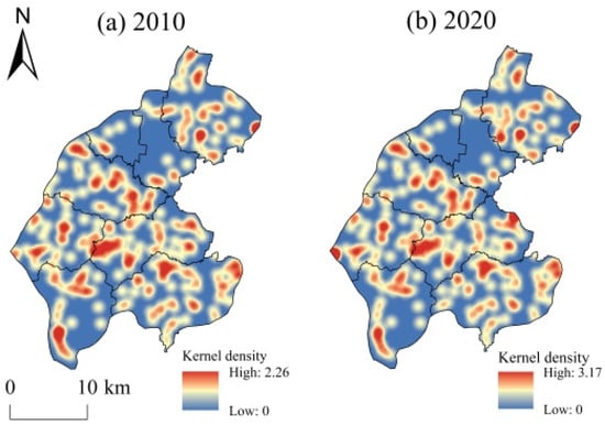
Figure 6.
The distribution of kernel density in Pingyin County from 2010 to 2020. (a) 2010; (b) 2020.
The ENN_MN of rural settlements in Pingyin County showed a downward trend, while the AI showed an upward trend, indicating that the distance between the settlement patches was decreasing. The proportion of the largest patch size increased from 0.38% to 0.53%, especially in Kongcun Town, which demonstrated that rural settlements tended to agglomerate on the whole. To further verify the spatial correlation between rural settlements, a global spatial autocorrelation analysis was carried out on the patch size of rural settlements in Pingyin County using GeoDa. It was found that Moran’s I was 0.0767 and 0.1084 in 2010 and 2020, respectively, indicating that there was a spatial correlation between rural settlements in this county and that the correlation increased during the study period.
3.2. The Spatial Differentiation of Development Foundations of Rural Settlements in Pingyin County
In the evaluation system for the development foundation of rural settlements, population density and distance from cities and towns had the largest weights, while natural conditions had a smaller weight, meaning that the natural environment exerted less impact on rural settlements than socio-economic factors. The weights of economic foundation indicators were mostly greater than 0.06, showing they had a pivotal role in the formation and development of rural settlements.
3.2.1. The Spatial Distribution of Development Elements
The scores for the natural conditions, socio-economic foundations, and location advantages of each rural settlement were visualized using ArcGIS (Figure 7a–c), which showed that the three elements exhibited obvious spatial differentiation. The natural conditions were better in the eastern and western parts than in the central part. The main reason is that the tail of Mount Tai runs through the central part of Pingyin County, resulting in the disadvantageous natural conditions of the rural settlements here. The socio-economic foundations presented multiple cores. The economic core of each town was generally the settlement where the town government was located, which was the growth pole of local economic development. The location advantage was higher in the northern settlements, mainly due to their shorter distances from the urban area, leading to easier radiation from the urban area. Judging from the RD (Figure 7d), the high-value centers were concentrated around the urban area, and the rural settlements in Yushan Subdistrict, Jinshui Subdistrict, and the town government seats all had higher scores.
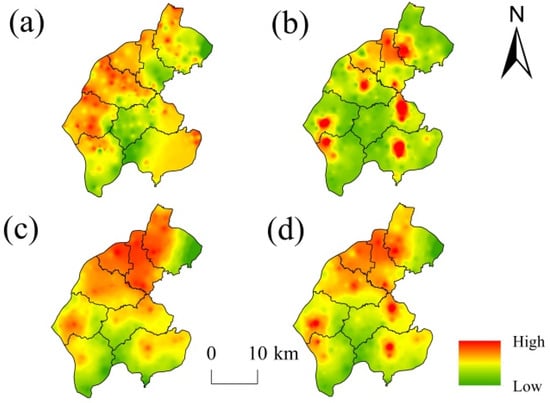
Figure 7.
The scores for rural settlements in Pingyin County based on the optimization model. (a) Natural conditions; (b) socio-economic foundations; (c) location advantages; (d) RD.
3.2.2. The Spatial Distribution of Rural Settlements at Different Levels
According to the RD of each rural settlement, the natural breakpoint method was used to divide the rural settlements into four levels: I, II, III, and IV (Figure 8). The spatial distribution of rural settlements at different levels exhibited an obvious core–periphery structure. In other words, Level I settlements were concentrated near town (subdistrict) government seats, and the peripheral area was dominated by level IV settlements. This indicates that the administrative center in the town (subdistrict) remained the core of development, and the development of settlements in the peripheral area was attenuated with distance.
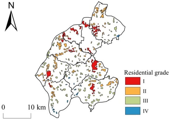
Figure 8.
The spatial pattern of rural settlements at different levels in Pingyin County.
There were 31 level I rural settlements with an area of 24.76 km2, mainly distributed in the administrative center of each town (subdistrict) in the form of large patches. These settlements were “overall dispersed and partially agglomerated”. Good natural conditions, socio-economic foundations, and location advantages resulted in dense and highly concentrated populations and economic activities, and non-agricultural industrial activities were highly developed here. Level I settlements were most widely distributed in Yushan Subdistrict and Jinshui Subdistrict, due to their proximity to the urban area. The proportion of level I settlements did not exceed 10% in Kongcun Town and Dong’e Town, but their areas accounted for 45.80% and 25.57%, respectively, suggesting that the level I settlements were concentrated. The level I settlements in Hongfanchi Town and Xiaozhi Town were only distributed near the town government seat, with small areas. There were 90 level II rural settlements with an area of 29.25 km2, which were mainly large settlements around the level I settlements and at the edge of the town, forming a strip-shaped area in the west of Pingyin County. Although the location conditions of these settlements were not as good as those of level I settlements, they were relatively large in scale, supported by characteristic rural industries, and highly developed with respect to non-agricultural industries. Level II settlements were widely distributed in Meigui Town and Ancheng Town, and their number and area ratios were higher than the county average. The level II settlements in Yushan Subdistrict were small and scattered, and their number ratio was much lower than their area ratio.
There were 120 level III rural settlements with an area of 23.33 km2, which were mainly distributed around level II settlements. These settlements enjoyed medium economic development foundations and location advantages, and relatively developed rural industrial economy, but they lagged considerably behind the level I and II settlements. Their advantage was that cultivated land resources were abundant, and the residents were mainly engaged in manufacturing and economic agriculture. Level III rural settlements were not found in Jinshui Subdistrict, were widely distributed in Hongfanchi Town and Xiaozhi Town, and were small and scattered in Dong’e Town. There were 21 level IV rural settlements, with an area of 2.43 km2, mainly scattered in the form of small patches on the edge of the town. The economic foundation of these settlements had obviously been left behind by the settlements at other levels. The location disadvantage of being far away from the urban area resulted in fewer development opportunities, but the cultivated land resources were abundant, and the residents were mainly engaged in traditional agricultural production. Level IV rural settlements were not found in Jinshui Subdistrict, Yushan Subdistrict, and Meigui Town. Those in Hongfanchi Town accounted for the largest number and area. The number of level IV settlements in Ancheng Town and Xiaozhi Town both accounted for more than 10%, but the area in Ancheng Town accounted for only 0.60%.
3.3. The Development Model for Rural Settlements in Pingyin County
Properly promoting land consolidation and distribution in rural settlements according to local conditions and determining the development model is an important guarantee for increasing the area of cultivated land, promoting the construction of new rural areas, and strengthening rural revitalization in the context of rural shrinkage [53]. Therefore, we classified the development models for rural settlements in Pingyin County using the theoretical development model for rural settlements in Pingyin County (Figure 9), based on its location, transportation, industry, and resource advantages, under the strategic guidance of Pingyin County’s “14th Five-Year Plan” and “Rural Revitalization Strategic Plan”. The purpose was to promote Pingyin County’s urban–rural integrated development and rural revitalization strategy.
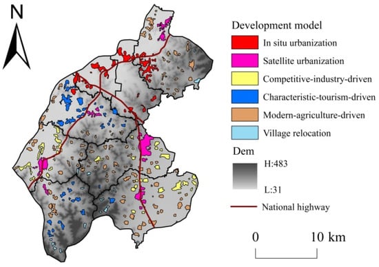
Figure 9.
The development model for rural settlements in Pingyin County.
In situ urbanization: This type of rural settlement includes 28 level I rural settlements in the whole of Yushan Subdistrict and Jinshui Subdistrict, as well as the parts of Ancheng Town and Meigui Town near the urban area, with an area of 13.26 km2. These settlements are closer to the central urban area and are more likely to be driven by the urban area. In addition, their own economic development foundation is solid. As the direct hinterland of the central urban area, they should be used to realize in situ urbanization. In so doing, the overall urbanization level of the region may be improved, and the region may avoid being affected by the urban siphon effect. These rural settlements should be oriented to: (1) giving full play to the guiding role of financial funds, attracting social capital to improve infrastructure construction, and speeding up the connection and clustering of infrastructure with central urban areas; (2) promoting the reform of the land system, separating the ownership, contract rights, and management rights, clarifying the relationship between land property rights, and increasing residents’ incomes; and (3) strengthening the industrial, transportation, and ecological connection with the central urban area, improving the urbanization level of clustered settlements, and realizing the clustering development with the central urban area.
Satellite urbanization: This type of rural settlement is mainly distributed in the administrative center of the town, including 16 level I settlements where the government offices of Meigui Town, Dong’e Town, Kongcun Town, Xiaozhi Town, and Hongfanchi Town are located, with an area of 15.59 km2. These rural settlements are not necessarily close to urban areas, but they are relatively advanced in terms of area, population, economic scale, and transportation accessibility. They are the administrative, economic, and transportation centers of each town. These rural settlements should be oriented to: (1) strengthening their role as a link between urban and rural areas, undertaking industrial transfer from central urban areas, optimizing and upgrading the industrial structure, and attracting out-of-town residents to return to their hometowns for entrepreneurship and employment through industrial integration and development [54]; (2) improving the construction of large shopping malls, hospitals, schools, and other public service facilities to enhance the convenience of residents’ lives; and (3) optimizing and integrating rural residential land, establishing large-scale central communities, and improving the degree of intensive land use.
Competitive-industry-driven: This type of rural settlement mainly includes 38 level II settlements in the three industrially developed towns of Kongcun, Xiaozhi, and Dong’e, with an area of 12.81 km2. These are the settlements with the highest development level apart from the administrative centers of the towns (subdistricts). The flat terrain here is conducive to the large-scale development of industries. The development foundation of local competitive industries can drive regional development. The three towns have different focuses due to their different development foundations: Kongcun Town focuses on the development of mechanical processing and manufacturing and new material industries that support urban areas; Xiaozhi Town actively develops bazaars and processing and manufacturing industries such as machinery and building materials; and Dong’e Town develops industries such as specialty foods and biopharmaceuticals. These rural settlements should be oriented to: (1) scaling up production based on the existing industrial base, integrating the original family workshops and small factories into specialty product factories, and forming a scale effect of “one town, one product”; (2) carrying out deep processing of products, improving product quality, and forming a brand effect, thus expanding the product sales market; and (3) extending the product industry chain, improving product value, increasing employment, attracting residents from characteristic-tourism-driven and modern-agriculture-driven settlements to find employment during slack seasons, easing the employment pressure of rural settlements featuring in situ urbanization and satellite urbanization, and increasing farmers’ incomes from non-agricultural industries.
Characteristic-tourism-driven: This type of rural settlement is mainly distributed in the west of Meigui Town and the middle of Hongfanchi Town and includes 39 rural settlements with characteristic tourism resources and development potential in each town, with an area of 11.89 km2. Since Hongfanchi Town and Meigui Town boast developed tourism resources, they should strengthen the construction of transportation infrastructure, explore the traditional construction of traditional villages, develop all-for-one tourism, and attract tourists for tourism, health care, and elderly care based on these tourism resources. These rural settlements should: (1) in Hongfanchi Town, proactively develop characteristic tourism and leisure and vacation tourism, relying on the advantages of the tourism resources of Hongfanchi Pool water and Dazhai Mountain Forest Park; (2) in Meigui Town, take the opportunity of characteristic town construction and develop characteristic tourism and leisure sightseeing based on the characteristic resource advantages of the Town of Roses and Cuiping Mountain Scenic Area; (3) effectively protect the overall spatial pattern and environment of traditional villages and natural and pastoral landscapes, maintain the integrity, authenticity, and continuity of the villages, and improve the public facilities and public environment of these villages. They should also make rational use of characteristic rural resources, develop rural tourism and characteristic industries, and form a mutual promotional mechanism balancing characteristic resource protection and rural development.
Modern-agriculture-driven: This type of rural settlement is mainly distributed in the central uplift area of Pingyin County and the grain production areas along the Yellow River and the Huihe River, involving 119 rural settlements with an area of 23.42 km2. These rural settlements should: (1) in the central mountainous area, adopt a production mode of forest fruits, and flowers on the ditch and edible fungi under the ditch based on the local terrain conditions, develop agricultural and rural elements, and cultivate forest fruit picking, farmhouses, and other leisure tourism relying on the construction of characteristic towns, beautiful villages, and pastoral complexes; (2) in the grain production areas along the Yellow River and the Huihe River, strengthen the agricultural production infrastructure, concentrate the fragmented cultivated land patches, realize large-scale production, and ensure an increase in grain production and income; and (3) increase scientific and technological investment in agricultural production, improve the quality of agricultural products through deep processing, refined packaging, and other means, develop characteristic agricultural products, transform industries to non-agricultural ones, and provide more employment opportunities for local farmers.
Village relocation: This type mainly includes 22 rural settlements on the edge of the town and in areas classified as red line ecological protection and nature reserves, with an area of 2.78 km2. Such rural settlements are generally located in high-altitude mountainous areas and are small, economically underdeveloped, and fragile in climate, but they enjoy high vegetation coverage and a good ecological environment. To protect the local ecological environment and optimize the land use structure, they adopt a development model of joint relocation of residents. These rural settlements should be oriented to: (1) fully respecting the will of the residents, mobilizing the residents to relocate in an orderly way to nearby settlements with convenient transportation and a developed economy town by town, and actively arranging for the residents to achieve re-employment in the relocated areas and (2) rearranging and converting abandoned homesteads into cultivated land, woodland, grassland, etc.
4. Discussion
4.1. The Relationship between Development Model and National Strategy
The National Rural Revitalization Strategic Plan (2018–2022) (hereinafter referred to as the Plan) classifies rural development into four categories: agglomeration, urban–suburban integration, characteristic protection, and relocation and mergers. The six development models delineated in this paper are both interrelated with, and different from, the four types in the Plan.
Firstly, the Plan serves as the basis for the development models in this study. For example, the competitive-industry-driven and modern-agriculture-driven types are refined on the basis of the aggregation type in the Plan, according to its provisions to give full play to comparative advantages and strengthen the support of leading industries. On the other hand, there are many similarities between the types in our study and in the Plan. The in situ urbanization type is similar to the urban–suburban integration type therein, aiming to promote urbanization by integrating the residential areas with urbanization potential near the urban area. The characteristic-tourism-driven type is similar to the characteristic protection type in the Plan, aiming to protect and develop residential areas with characteristic resources. The village relocation type is similar to the relocation and merger type in the Plan, concerned with relocating the residents in areas with fragile ecological environments or small populations, to achieve agglomerated development.
Secondly, the two classifications focus on different aspects. The classification in the Plan is based on the overall situation of China’s rural areas and aims to promote rural revitalization around the country. In contrast, the development model in this study is constructed from a micro perspective based on the development foundation and spatial pattern of rural settlements, which is more empirical, adaptable, and operable. In addition, this study pays more attention to the development of rural settlements. For example, the competitive-industry-driven and characteristic-agriculture-driven models are dedicated to industrial and agricultural development, respectively. The satellite urbanization type aims to allow core settlements to play the role of growth poles. Finally, the actual application of these models must fully consider the actual situations of the villages, and the villages should be properly classified according to their local conditions.
4.2. Research Contributions and Limitations
The relationship between humans and land in rural areas has always been a focus of geographers [55]. Although rural population loss and residential land expansion have attracted extensive scholarly attention, little attention has been paid to the theoretical process of their evolution at different urbanization stages. This study analyzes the evolution of rural populations and residential land use at the early, middle, and late stages of urbanization, particularly the contradiction between the two at the middle stage of urbanization, which is consistent with the research ideas of Shang et al. [56]. In terms of research content, unlike previous studies on the layout and evolution of rural residential land use [57,58], this paper aims to explore proper development models based on the actual conditions of rural residential areas, in order to promote high-quality development and rural revitalization strategies in rural areas. In terms of research methods, the present study combines landscape metrics and geospatial analysis and takes into account the development foundations and spatial layouts in rural areas. On this basis, it adopts a two-step method to determine the development model based on a classification matrix composed of the two elements. This method is more convincing than the evaluation of rural development foundations based on rural suitability [14,59] or an index system [54].
The empirical study on Pingyin County demonstrated that the rural residential development model based on development foundations and spatial patterns is feasible for villages in temperate plain-type counties, although it should be verified and promoted in other regions. However, this does not mean that the model is necessarily applicable to all regions, nor that all rural settlements applicable to the model can be classified into six development models. For example, it may not be the case for rural settlements on islands or in special terrain areas such as plateaus, mountains, and extremely fragile ecological environments. There are a number of limitations to this study. Firstly, when determining the development model for rural settlements, this study did not factor in actual survey data or farmers’ living habits and relocation willingness, which is also an important factor for the optimization of rural settlements in the future. Secondly, the rural settlements in this study are similar to natural villages and are not the basic administrative units in China (administrative villages). This study did not formulate a development model for administrative villages to make it more compatible with the actual development of China’s rural areas, and this is worth exploring in future research. Thirdly, the present study did not discuss the division of the functions and development types of each township in Pingyin County on a larger scale. In fact, the marginal districts and counties especially will be influenced to a large extent by other administrative units and may form other functional orientations.
5. Conclusions
This article focused on the development model for rural settlements in the context of rural shrinkage. First, it clarified the relationship between the increase and decrease in rural populations and settlements at different urbanization stages and built a theoretical development model for rural settlements based on the development foundation and spatial pattern. Then, a case study was conducted on Pingyin County, China, illuminating the spatial pattern of its rural settlements, classifying the development models, and determining the development orientation based on the scores of the basic evaluation model for the development foundation of rural settlements. The main conclusions are as follows:
- (1)
- The spatial distribution of rural settlements in Pingyin County presents a core–edge structure. Large settlement patches are distributed in the administrative centers of each town (subdistrict), while small patches are distributed at the edge. The degree of agglomeration and spatial correlation is strengthened with an increase in the scale of rural settlements. These rural settlements tend to be irregular, but the overall distribution pattern has not changed significantly.
- (2)
- The natural conditions are better in the eastern part than in the central part of Pingyin County, the socio-economic foundations are distributed in multiple cores, the location advantage is higher in the north, and the spatial distribution of rural settlements at different levels presents an obvious core–edge structure. Level I rural settlements are “overall dispersed and partially agglomerated” and are most widely distributed in Yushan Subdistrict and Jinshui Subdistrict. Level II settlements are mainly large-scale settlements around the level I settlements and are on the edge of the town. Level IV settlements are primarily scattered around the edges of towns in the form of small patches.
- (3)
- This study classified the development models into six types based on the development foundation and spatial pattern of rural settlements in Pingyin County: in situ urbanization, satellite urbanization, competitive-industry-driven, characteristic-tourism-driven, modern-agriculture-driven, and village relocation. It also proposed different development strategies for different development models, aiming to find a path to sustainable development suitable for the local reality based on the development advantages of different rural settlements.
Author Contributions
Conceptualization, S.Y. and C.W.; methodology, S.Y. and Y.M.; software, S.Y.; validation, Y.M.; writing—original draft preparation, S.Y.; writing—review and editing, Y.M., M.L., X.D., C.W. and W.D.; supervision, C.W. funding acquisition, C.W. All authors have read and agreed to the published version of the manuscript.
Funding
This research was funded by the National Social Science Foundation of China (Grant No. 20BJY070).
Institutional Review Board Statement
Not applicable.
Informed Consent Statement
Not applicable.
Data Availability Statement
The data presented in this study are available on request from the corresponding author.
Acknowledgments
We express our sincere thanks to the editor and anonymous reviewers for their comments and suggestions, which considerably helped to improve the quality of this study. We are solely responsible for the opinions expressed in this study.
Conflicts of Interest
The authors declare no conflict of interest.
References
- Wen, Y.Y.; Zhang, Z.F.; Liang, D.; Xu, Z. Rural Residential Land Transition in the Beijing-Tianjin-Hebei region: Spatial-Temporal Patterns and Policy Implications. Land Use Policy 2020, 96, 104700. [Google Scholar] [CrossRef]
- Lv, D.H.; Zhang, Y.; Liu, Y.Q. Spatial Coupling Relationship Between Rural Population and Economy Under the Background of Rural Shrinkage in Songnen Plain. Econ. Geogr. 2022, 42, 160–167. [Google Scholar] [CrossRef]
- Anne, T.; Gertrud, J. Translating a Wicked Problem: A Strategic Planning Approach to Rural Shrinkage in Denmark. Landsc. Urban Plan. 2016, 154, 29–43. [Google Scholar] [CrossRef]
- Qu, Y.B.; Zhan, L.Y.; Jiang, G.H.; Ma, W.Q.; Dong, X.Z. How to Address “Population Decline and Land Expansion (PDLE)” of Rural Residential Areas in the Process of Urbanization: A Comparative Regional Analysis of Human-Land Interaction in Shandong Province. Habitat Int. 2021, 117, 102441. [Google Scholar] [CrossRef]
- Tan, S.K.; Zhang, M.M.; Wang, A.; Ni, Q.L. Spatio-Temporal Evolution and Driving Factors of Rural Settlements in Low Hilly Region—A Case Study Of 17 Cities in Hubei Province, China. Int. J. Environ. Res. Public Health 2021, 18, 2387. [Google Scholar] [CrossRef]
- Chen, Z.F.; Liu, X.Q.; Lu, Z.; Li, Y.R. The Expansion Mechanism of Rural Residential Land and Implications for Sustainable Regional Development: Evidence from the Baota District in China’s Loess Plateau. Land 2021, 10, 172. [Google Scholar] [CrossRef]
- Chen, C.; Gao, J.L.; Chen, J.L. Institutional Changes, Land Use Dynamics, And the Transition of Rural Settlements in Suburban China: A Case Study of Huishan District in Wuxi City. Habitat Int. 2017, 70, 24–33. [Google Scholar] [CrossRef]
- Dong, G.L.; Xu, E.Q.; Zhang, H.Q. The Spatial Distribution and Evolution of Different Types of Rural Settlements on Huang-Huai-Hai Plain. Resour. Sci. 2017, 39, 1248–1258. [Google Scholar] [CrossRef][Green Version]
- Xu, F.; Hung, C.H.; Chi, G.Q.; Wang, Z.Q. Abandoned Rural Residential Land: Using Machine Learning Techniques to Identify Rural Residential Land Vulnerable to be Abandoned in Mountainous Areas. Habitat Int. 2019, 84, 43–56. [Google Scholar] [CrossRef]
- Wang, Z.H.; Yang, X.M. An Edge-Suppressed Points Voting Method for Extracting Rural Residential Areas from High Spatial Resolution Images. Remote Sens. Lett. 2017, 8, 380–388. [Google Scholar] [CrossRef]
- Peter, M.O.; Linda, T.E.; Lucinda, G.; Michael, L.B.; Sandy, B.; Madeline, A.D. Smart Density: A More Accurate Method of Measuring Rural Residential Density for Health-Related Research. Int. J. Health Geogr. 2010, 9, 8. [Google Scholar] [CrossRef]
- Stefan, L.; Matt, R.; Barbara, P.B.; Nicholas, N.N.; Alexander, K.S. Modeling Residential Developed Land in Rural Areas: A Size-Restricted Approach Using Parcel Data. Appl. Geogr. 2014, 47, 33–45. [Google Scholar] [CrossRef]
- Wang, K.; Zhou, W.Q.; Xu, K.P.; Liang, H.M.; Yu, W.J.; Li, W.F. Quantifying Changes of Villages in the Urbanizing Beijing Metropolitan Region: Integrating Remote Sensing and GIS Analysis. Remote Sens. 2017, 9, 448. [Google Scholar] [CrossRef]
- Guo, P.F.; Zhang, F.F.; Wang, H.Y.; Qin, F. Suitability Evaluation and Layout Optimization of the Spatial Distribution of Rural Residential Areas. Sustainability 2020, 12, 2409. [Google Scholar] [CrossRef]
- Ma, W.Q.; Jiang, G.H.; Li, W.Q.; Zhou, T.; Zhang, R.J. Multifunctionality Assessment of the Land Use System in Rural Residential Areas: Confronting Land Use Supply with Rural Sustainability Demand. J. Environ. Manag. 2019, 231, 73–85. [Google Scholar] [CrossRef]
- Guan, X.K.; Wang, X.L.; Zhang, B.L.; Ren, Y.Y.; Li, L. Morphological Characteristics Identification and Adjustment of Typical Rural Settlements Based on Different Economic Gradient Regions. Econ. Geogr. 2018, 38, 190–200. [Google Scholar] [CrossRef]
- Zhou, T.; Jiang, G.H.; Ma, W.Q.; Li, G.Y.; Qu, Y.B.; Tian, Y.Y.; Zhao, Q.L.; Tian, Y.Y. Dying Villages to Prosperous Villages: A Perspective from Revitalization of Idle Rural Residential Land (IRRL). J. Rural. Stud. 2021, 84, 45–54. [Google Scholar] [CrossRef]
- Tong, Y.; Niu, H.P.; Fan, L.X. Willingness of Farmers to Transform Vacant Rural Residential Land into Cultivated Land in A Major Grain-Producing Area of Central China. Sustainability 2016, 8, 1192. [Google Scholar] [CrossRef]
- Tian, G.J.; Yang, Z.F.; Zhang, Y.Q. The Spatio-Temporal Dynamic Pattern of Rural Residential Land in China in the 1990s Using Landsat TM Images and GIS. Environ. Manag. 2007, 40, 803–813. [Google Scholar] [CrossRef]
- Ma, W.Q.; Jiang, G.H.; Li, W.Q.; Zhou, T. How Do Population Decline, Urban Sprawl and Industrial Transformation Impact Land Use Change in Rural Residential Areas? A Comparative Regional Analysis at The Peri-Urban Interface. J. Clean. Prod. 2018, 205, 76–85. [Google Scholar] [CrossRef]
- Pan, W.; Wang, J.; Qin, X.F.; Li, Y.R. Trends and Types of Rural Residential Land Use Change in China: A Process Analysis Perspective. Growth Chang. 2021, 52, 2437–2452. [Google Scholar] [CrossRef]
- Ma, W.Q.; Jiang, G.H.; Zhang, R.J.; Li, Y.L.; Jiang, X.G. Achieving Rural Spatial Restructuring in China: A Suitable Framework to Understand How Structural Transitions in Rural Residential Land Differ Across Peri-Urban Interface? Land Use Policy 2018, 75, 583–593. [Google Scholar] [CrossRef]
- Li, X.Q.; Wang, Y.C.; Xu, X.Q. Spatiotemporal Evolution Pattern and Influencing Factors of Rural Settlements in Karst Areas. Res. Soil Water Conserv. 2022, 29, 375–382. [Google Scholar] [CrossRef]
- Wang, Z.L.; Yang, Q.Y.; Li, J.; Wang, Y.; E, S.X.; Yang, H.; Sun, S.R. Optimization Strategy of Rural Settlement Layout in Mountainous Urban Fringe Area: A Case Study of Shichuan Town in Yubei District of Chongqing. Econ. Geogr. 2019, 39, 182–190. [Google Scholar] [CrossRef]
- Huang, B.Y.; Xie, B.P.; Chen, Y.; Wang, T.B.; Tao, W.Q.; Pei, T.T. Optimizing the Layout of Rural Residential Areas Using Location Suitability and Ecological Sensitivity: A Case Study of Gaize County, Tibet. J. Agric. Resour. Environ. 2022, 39, 406–416. [Google Scholar] [CrossRef]
- Yang, D.L.; Sun, J.L.; Zhang, Y.; Luo, J.; Zhao, Y.L.; Zhang, J. Classification of Consolidation Type of Rural Settlements in Karst Mountainous Areas Based on “Production-Living-Ecological” Functions: Taking Qixingguan District as An Example. China Land Sci. 2021, 35, 80–89. [Google Scholar] [CrossRef]
- Li, Y.C.; Jia, L.R.; Wu, W.H.; Yan, J.Y.; Liu, Y.S. Urbanization for Rural Sustainability—Rethinking China’s Urbanization Strategy. J. Clean. Prod. 2018, 178, 580–586. [Google Scholar] [CrossRef]
- Qu, Y.B.; Dong, X.Z.; Zhan, L.Y.; Si, H.Y.; Ping, Z.L.; Zhu, W.Y. Scale Transition and Structure–Function Synergy Differentiation of Rural Residential Land: A Dimensionality Reduction Transmission Process from Macro to Micro Scale. Land 2021, 10, 647. [Google Scholar] [CrossRef]
- Diane, K.M.; Carla, M.S.; Mary, A.D. Influence of Perceptions of Current and Future Community on Residential Aspirations of Rural Youth. Rural. Sociol. 2014, 79, 453–477. [Google Scholar] [CrossRef]
- Shi, L.N.; Wang, Y.S. Evolution Characteristics and Driving Factors of Negative Decoupled Rural Residential Land and Resident Population in the Yellow River Basin. Land Use Policy 2021, 109, 105685. [Google Scholar] [CrossRef]
- Xu, H.Z.; Liu, Y.X. Policy Implications and Impact of Household Registration System on Peasants’ Willingness to Return Rural Residential Lands: Evidence from Household Survey in Rural China. Panoeconomicus 2016, 63, 135–146. [Google Scholar] [CrossRef]
- Jiménez, V.; Sánchez, J.M.; Rengifo, J.I. A New Residential Role for the Rural Environment in Extremadura, Spain. Sustainability 2019, 11, 435. [Google Scholar] [CrossRef]
- Igal, C.; Michal, P. Interpreting the Repopulation of Rural Communities: The Case of Private Neighbourhoods in Kibbutzim. Popul. Space Place 2014, 20, 664–676. [Google Scholar] [CrossRef]
- Menelaos, G.; Mark, S. Residential Mobilities and House Building in Rural Ireland: Evidence from Three Case Studies. Sociol. Rural. 2009, 50, 64–84. [Google Scholar] [CrossRef]
- Chen, C.; Shen, X.; Yang, Q.Z. International Progress and Enlightenment of Rural Gentrification Research. Agric. Technol. 2021, 41, 133–139. [Google Scholar] [CrossRef]
- Zhang, X.S.; He, J.; Deng, Z.; Ma, J.Y.; Chen, G.P.; Zhang, M.M.; Li, D.S. Comparative Changes of Influence Factors of Rural Residential Area Based on Spatial Econometric Regression Model: A Case Study of Lishan Township, Hubei Province, China. Sustainability 2018, 10, 3403. [Google Scholar] [CrossRef]
- Liu, J.; Jin, X.B.; Fan, Y.T.; Xiang, X.M.; Ran, N.; Zhou, Y.K.; Shen, C.Z. Rural Residential Land Consolidation Strategy from a Perspective Synthesizing Towns, Villages and Land Parcels: A Case Study in Xinyi City, Jiangsu Province. Geogr. Res. 2018, 37, 678–694. [Google Scholar] [CrossRef]
- Miao, Y.; Song, J.P.; Xiu, F.R.; Wang, X.Y. Rural Development Pattern and Optimization in County Region Based on Coupling Relationship: A Case Study of Hanting District. Hum. Geogr. 2021, 36, 165–173. [Google Scholar] [CrossRef]
- Liu, T.; Ren, G.M.; Wang, M.; Yu, T.B. Suitability Evaluation of Rural Residential Areas Under the Threat of Geological Disasters: A Case Study in Yinchanggou Watershed of Pengzhou City. Geol. Surv. China 2020, 7, 95–100. [Google Scholar] [CrossRef]
- Feng, C.C.; Zhao, R.X.; Gu, W.Y. Study on the Social Economic Factors of the Land Use Changes in Rural Residential Areas of China. China Popul. Resour. Environ. 2012, 22, 6–12. [Google Scholar] [CrossRef]
- Li, L.Y.; Sun, Z.X.; Long, X. An Empirical Analysis of Night-Time Light Data Based on the Gravity Model. Appl. Econ. 2019, 51, 797–814. [Google Scholar] [CrossRef]
- Yang, R.; Zhang, J.; Chen, Y.C. Differentiation and Dynamic Mechanism of Rural Development in Metropolitan Fringe Based on the Functional Perspective in Guangzhou City. Sci. Geogr. Sin. 2021, 41, 232–242. [Google Scholar] [CrossRef]
- Fan, T.X.; Yang, Q.Y.; He, J.; Pan, F.; Deng, Y.W. Spatial Distribution Optimization of Rural Residential Land in Hilly Areas: A Case Study of Haitang Town in Changshou District. Geogr. Res. 2015, 34, 883–894. [Google Scholar] [CrossRef]
- Huang, C.; Zhao, X.M.; Guo, X.; Xie, W.; Zhang, J.J.; Ye, Y.C. Study on the Rural Residential Layout Optimization of Yujiang County Based on Kernel Density. J. China Agric. Univ. 2016, 21, 165–174. [Google Scholar] [CrossRef]
- Li, H.B.; Liu, M.D.; Hu, X.L.; Chen, X.H. Characteristics and Type Classification of Rural Human Settlement Space Change from Smart Decline Viewpoint: A Case Study of Changshu City, Jiangsu Province. Geogr. Res. 2020, 39, 939–955. [Google Scholar] [CrossRef]
- Ma, L.B.; Gong, M.; Liu, S.C.; Cui, X.J. Identification of Spatial Reconstruction Types of Rural Settlements Based on Residential Suitability: A Case Study of Weidian Town in the Loess Hilly Region of Longzhong. Sci. Geogr. Sin. 2022, 42, 456–465. [Google Scholar] [CrossRef]
- Guo, Z.; Yao, S.M.; Chen, S.; Wu, W.; Liu, W.C. Spatial-Temporal Evolution of the Livability Levels in the Yangtze River Delta Urban Agglomerations and Its Influencing Factors. Econ. Geogr. 2020, 40, 79–88. [Google Scholar] [CrossRef]
- Hua, L.; Huang, Z.L.; Ma, L.; Huang, J.Y.; Zhou, G.Y. Suitable Granularity and Response of Multi-Scale Landscape in Low Mountain and Hilly Area of the Three Gorges Reservoir. Acta Ecol. Sin. 2022, 42, 4703–4717. [Google Scholar] [CrossRef]
- Fu, G.; Wang, W.; Li, J.S.; Xiao, N.W.; Qi, Y. Prediction and Selection of Appropriate Landscape Metrics and Optimal Scale Ranges Based on Multi-Scale Interaction Analysis. Land 2021, 10, 1192. [Google Scholar] [CrossRef]
- Peng, J.; Wang, Y.L.; Zhang, Y.; Wu, J.S.; Li, W.F.; Li, Y. Evaluating the Effectiveness of Landscape Metrics in Quantifying Spatial Patterns. Ecol. Indic. 2010, 10, 217–223. [Google Scholar] [CrossRef]
- Liu, Y.; Li, P.; Xiao, C.W.; Liu, J.; Ye, J.Q.; Shi, D. Spatial Characteristics and National Differences of Active Fires Derived from Visible Infrared Imaging Radiometer Suite (VIIRS) In Mainland Southeast Asia in the Dry Season During 2012–2019. Prog. Geogr. 2021, 40, 1406–1418. [Google Scholar] [CrossRef]
- Li, Y.Y.; Li, F.; Chen, C. The Spatial Evolution Characteristics and Driving Forces of Village and Town Settlements in the Qinghai-Tibet Plateau. Res. Agric. Mod. 2021, 42, 1114–1125. [Google Scholar] [CrossRef]
- Li, Y.R.; Liu, Y.S.; Long, H.L.; Cui, W.G. Community-Based Rural Residential Land Consolidation and Allocation Can Help to Revitalize Hollowed Villages in Traditional Agricultural Areas of China: Evidence from Dancheng County, Henan Province. Land Use Policy 2014, 39, 188–198. [Google Scholar] [CrossRef]
- Li, J.T.; Yang, Y.Y.; Jiang, N. Mode of Rural Revitalization and Its Approaches in Beijing-Tianjin-Hebei Metropolitan Area: A Case Study of Jinghai District in Tianjin. Geogr. Res. 2019, 38, 496–508. [Google Scholar] [CrossRef]
- Cai, E.X.; Chen, W.Q.; Wei, H.j.; Li, J.W.; Wang, H.; Guo, Y.L.; Feng, X.W. The Coupling Characteristics of Population and Residential Land in Rural Areas of China and Its Implications for Sustainable Land Use. Sustain. Dev. 2020, 28, 646–656. [Google Scholar] [CrossRef]
- Shang, R.; Qu, Y.B.; Jiang, H.L. Spatiotemporal Characteristics and Formation Mechanism of Rural Residential Land Transition from the Perspective of Human-Land Relationship. Resour. Sci. 2020, 42, 672–684. [Google Scholar] [CrossRef]
- Yang, Y.; Deng, X.Z.; Wu, F.; Chen, T. An Analysis of Rural Settlement Evolution and Socioeconomic Affect Factors in North China Pain. Hum. Geogr. 2019, 34, 116–124. [Google Scholar] [CrossRef]
- Yue, R.C.; Lei, G.P.; Yin, J.D.; Ding, X.; Ma, X.P.; Wang, J.W. Analysis the Distribution Pattern and Influence Factors of Rural Settlements: A Case Study of Qing’an County. J. China Agric. Univ. 2017, 22, 173–180. [Google Scholar] [CrossRef]
- Hong, B.T.; Ren, P. Assessment of Ecological Suitability for Rural Residential Land Based on Minimum Cumulative Resistance Model: A Case Study in Dujiangyan City. Resour. Environ. Yangtze Basin 2019, 28, 1386–1396. [Google Scholar] [CrossRef]
Publisher’s Note: MDPI stays neutral with regard to jurisdictional claims in published maps and institutional affiliations. |
© 2022 by the authors. Licensee MDPI, Basel, Switzerland. This article is an open access article distributed under the terms and conditions of the Creative Commons Attribution (CC BY) license (https://creativecommons.org/licenses/by/4.0/).