Communication

Cumulative Tree Mortality from Commercial Thinning and a Large Wildfire in the Sierra Nevada, California

1
Los Padres ForestWatch, P.O. Box 831, Santa Barbara, CA 93102, USA
2
Earth Island Institute, 2150 Allston Way, Suite 460, Berkeley, CA 94704, USA
*
Author to whom correspondence should be addressed.
Land 2022, 11(7), 995; https://doi.org/10.3390/land11070995
Submission received: 4 May 2022 / Revised: 10 June 2022 / Accepted: 27 June 2022 / Published: 30 June 2022
(This article belongs to the Special Issue Forests in the Landscape: Threats and Opportunities)

Abstract

:
Debate remains about the effectiveness of commercial thinning as a wildfire management strategy, with some studies reporting somewhat lower severity in thinned forests, and some reporting higher severity, during wildfires. However, while vegetation severity is a measure of basal area tree mortality, research on this question generally omits tree mortality from thinning itself. We investigated whether cumulative tree mortality, or cumulative severity, from commercial thinning and wildfire was different between thinned and unthinned forests in the Caldor Fire of 2021 in the northern Sierra Nevada mountains of California, USA. We found significantly higher cumulative severity in commercial thinning areas compared to unthinned forests. More research is needed to determine whether cumulative severity is higher in commercially thinned forests in other large western US wildfires.

1. Introduction

Ongoing scientific debate regarding the effect of commercial thinning and other vegetation removal, or “fuel reduction” projects, in national forests of the western USA primarily focuses on the effects of such activities on subsequent wildfire vegetation severity, particularly tree mortality (e.g., basal area mortality). Despite the wide range of severity effects reported by different studies and continued disagreement about the ecological implications of widespread forest management activities, such as commercial thinning, and historical fire regimes in frequent-fire western USA forest types [1,2,3,4,5], some authors suggest that landscape-scale and potentially intensive tree removal is necessary to reduce wildfire severity or increase overall forest resilience [3,4,5]. This type of forest vegetation alteration is frequently implemented in the form of commercial thinning, which involves cutting mature trees and removing them from the forest as well as the removal of many small trees as part of project implementation.
One of the primary goals of contemporary commercial thinning projects in national forests of the western USA is to reduce wildfire effects. For example, the U.S. Forest Service stated in its decision notice for the “Callecat Ecological Restoration Project” in the Eldorado National Forest (Sierra Nevada, California) that one of the project’s objectives is to “[r]educe surface fuels and alter the vegetation structure in strategically placed areas to affect a reduction in fire severity and intensity”. Vegetation fire severity in forests is ultimately a measure of tree mortality [6,7], so whether a commercial thinning project reduces fire severity is a question of whether wildfire-related tree mortality is reduced relative to unthinned forests. Several studies have examined this question in western USA forests, some of which reported that tree mortality caused by subsequent wildfire was lower in at least some of the commercially thinned forests compared to nearby unthinned forests [4,5]. However, cumulative tree mortality from pre-fire commercial thinning and subsequent wildfire in thinned and unthinned forests has received little attention in the literature until recently [8].
The focus on fire-related mortality in most studies on commercial thinning ignores tree mortality caused by the thinning itself despite this human-induced disturbance resulting in significant mortality both in terms of basal area and number of trees. For example, if a commercially thinned plot experiences 10% basal area mortality compared to 20% in an adjacent unthinned plot in a wildfire, with both having approximately the same initial basal area before thinning occurred, then the commercial thinning would be deemed successful in reducing subsequent wildfire mortality or severity. However, if the thinning itself removed 30% of the basal area, then the cumulative severity would be 33% in the thinned plot compared to 20% in the unthinned plot. Cumulative tree mortality or cumulative severity [8] is thus an important but overlooked metric that elucidates whether more or fewer trees remain on the landscape after the combined effects of commercial thinning and wildfire.
Quantifying cumulative tree mortality is especially important considering the widespread implementation of landscape-scale commercial thinning projects across public and private forest lands in the western USA, spurred considerably by recent and upcoming legislation, such as the 2021 infrastructure law, that includes not only rollbacks of environmental review requirements by public land management agencies but also billions of US dollars in funding for thinning. In addition, commercial thinning in mature forests can remove or degrade important habitat such as dense, multilayered stands required by various imperiled native wildlife species, including California spotted owl (Strix occidentalis Xántus) and Pacific fisher (Pekania pennanti Erxleben) [9,10,11].
Unlike mixed-severity fire, which includes a high-severity fire component in which most or all trees are killed in patches, commercial thinning also removes whole tree biomass from forest ecosystems. Some studies have shown that thinning tends to remove significantly more carbon from western USA forests than it can prevent from being lost to wildfire due to changes to fire severity, in part due to low combustion levels of live trees in wildfires [12,13]. For example, recent fine-resolution, field-based analysis of wildfire-related live tree combustion finds that even with significant proportions of high severity fire effects, large wildfires (i.e., >40,000 ha) consume less than 2% of tree carbon due to the low combustion rates in the mature tree biomass pool [14], which contains most of the aboveground carbon in a given mature forest [15]. Thus, understanding cumulative severity can help illuminate assessments of the effect of forest management activities on forest carbon storage and inform climate change policy.
In this study we analyzed publicly available information from several relatively recent commercial thinning projects approved and implemented on national forest land, as well as immediate, post-fire severity data, to investigate whether cumulative severity was higher in thinned or unthinned forests that burned in the 2021 Caldor Fire in the Sierra Nevada, California. Specifically, our objective was to determine whether cumulative severity was different in commercially thinned forests compared to unthinned forests in the Caldor Fire.

2. Materials and Methods

The Caldor Fire burned 89,787 ha from August to October 2021 in the northern Sierra Nevada (Figure 1), crossing the crest of this range south of Lake Tahoe. We first limited our study area to only national forest land within the fire perimeter (81% of the total burned area). Most of the burned area on national forest land is comprised of mixed conifer forest dominated by ponderosa pine (Pinus ponderosa Douglas ex Loudon), Jeffrey pine (P. jeffreyi A. Murray bis), sugar pine (P. lambertiana Douglas), white fir (Abies concolor [Gordon & Glend.] Lindl. Ex Hildebr.), Douglas-fir (Pseudotsuga menziesii [Mirb.] Franco), and incense cedar (Calocedrus decurrens [Torr.] Florin). There are also large areas at higher elevation dominated by red fir (A. magnifica A. Murray bis) and lodgepole pine (P. contorta Loudon ssp. murrayana [Grev. & Balf.] Critchf.). Elevation in the study area ranges from 530 m to 2740 m. On the western side of the Caldor Fire, which is lower in elevation, annual daily mean temperature is 13.0 °C, with a mean high temperature of 32.2 °C in August, and annual mean precipitation is 1280 mm (https://prism.oregonstate.edu/explorer/, accessed on 27 May 2022). On the eastern side of the Caldor Fire, which is higher in elevation, annual daily mean temperature is 6.8 °C, with a mean high temperature of 26.5 °C in August, and annual mean precipitation is 520 mm.
Similar to Hanson (2021) [16], which also examined fire severity in thinned and unthinned forests in the Sierra Nevada, we further limited our study area to Jeffrey pine, ponderosa pine, and mixed conifer forest types using Biophysical Settings (BpS) data for the following forest types: Mediterranean California Dry-Mesic Mixed Conifer Forest and Woodland, Mediterranean California Mesic Mixed Conifer Forest and Woodland, Mediterranean California Lower Montane Black Oak-Conifer Forest and Woodland, and California Montane Jeffrey Pine (-Ponderosa Pine) Woodland. Thus, only national forest land both categorized as one of the BpS types listed above and within the Caldor Fire perimeter was included in our study area.
We obtained forest management data from the Forest Service Activity Tracking System (FACTS) accessed via multiple datasets (https://data.fs.usda.gov/geodata/edw/datasets.php, accessed 15 April 2022) including the timber harvest, timber stand improvement, hazardous fuel reduction, and post-thinning burn activity datasets. These datasets contain polygons each representing a different activity. We only included activities with a listed completion date preceding the Caldor Fire ignition date. Some commercial thinning units were not listed as completed prior to the fire but we included them if visual analysis of satellite imagery on Google Earth, which we used only as an aid, indicated canopy reduction had in fact occurred.
For commercial thinning areas, we included two categories: commercial thinning 1995–2021 with post-thin burning of slash debris (Thin/Burn); and commercial thinning 1995–2021 with no post-thin burning of slash debris (Thin/No-Burn). For our assessment of cumulative severity, we compared these commercial thinning categories to mature, unmanaged forest (no record of forest management in the FACTS database) with no fire activity 1995–2021 prior to the Caldor Fire (Mature Unmanaged). Because some unmanaged/unburned areas were nonforest based on visual analysis of satellite imagery, we used the CALVEG Existing Vegetation dataset crosswalked with the California Wildlife Habitat Relationship System (CWHR) to further refine our study area within this category specifically (recognizing that commercial thinning would, by definition, occur within areas of existing forest). Any unmanaged/unburned areas that did not have a canopy cover code indicating mature forest (CWHR 4M, 4D, 5M, and 5D) were excluded from the study area (see Figure 1 for the spatial distribution of all three management categories within the fire perimeter).
Caldor Fire perimeter and severity data were obtained from the Rapid Assessment of Vegetation Condition after Wildfire (RAVG). This dataset (https://burnseverity.cr.usgs.gov/products/ravg, accessed 15 April 2022) is created using Landsat imagery differencing methods described in Miller and Thode (2007) [7] with additional regression equations based on field data from several fires in the Sierra Nevada and northern California used to calculate percent basal area mortality and fire severity measures.
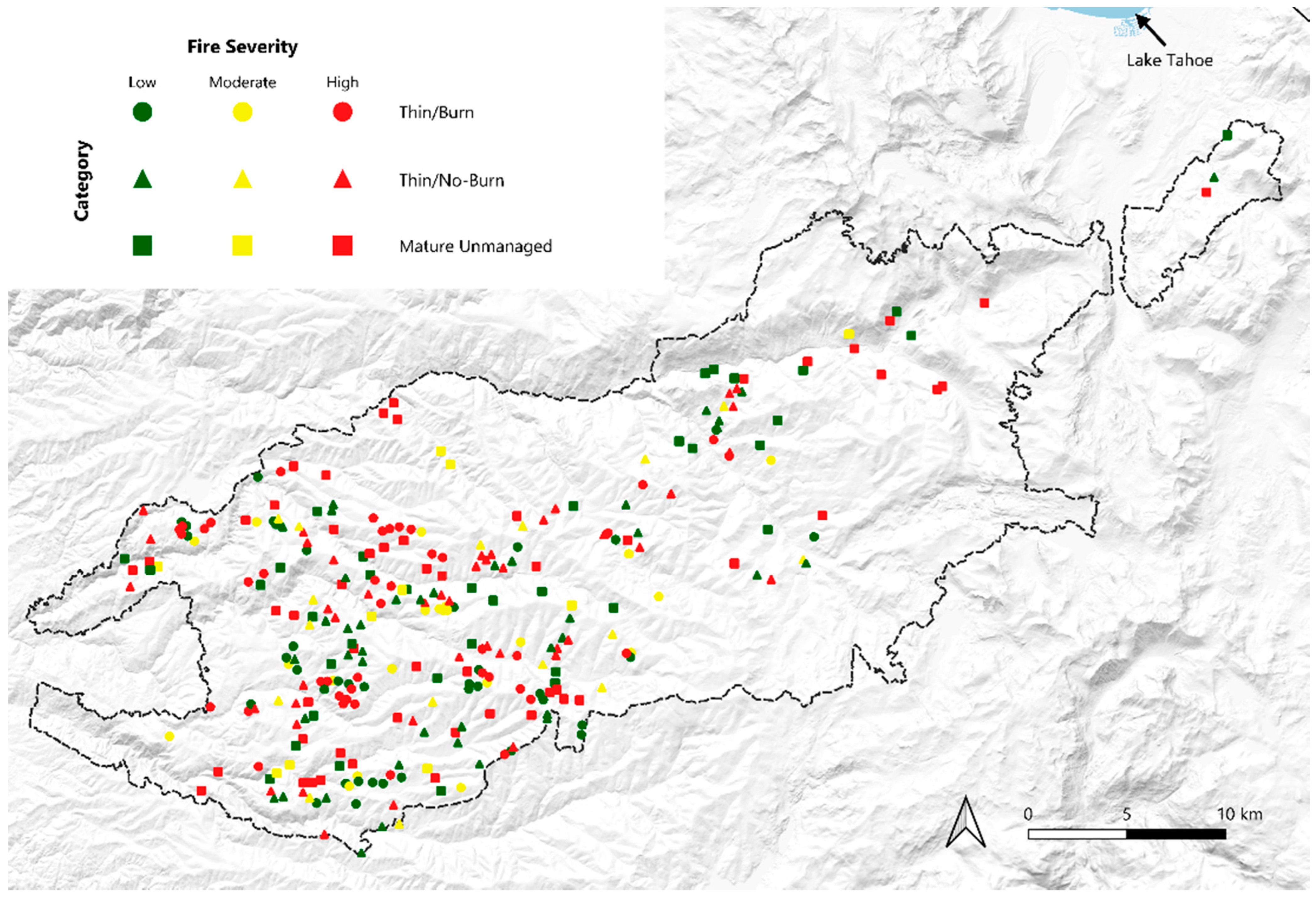
For our analyses, we used the thematic or categorized basal area dataset (BA4) which categorizes severity in 30 m2 pixels as unburned (0% basal area mortality), low (1–25% basal area mortality), moderate (25–75% basal area mortality), and high (>75% basal area mortality). We combined the two lowest categories into a single “low” category (0–25% basal area mortality) while leaving the moderate and high categories unchanged. We vectorized the BA4 dataset and unified it with our three management categories. We used the midpoint of basal area mortality for each of the three fire severity categories for our analyses of cumulative severity. We selected 100 random 30 m2 pixels for each of the three management categories to assess potential differences in cumulative severity, with a minimum distance of 200 m between randomly selected pixels. Random points used to select random pixels (a pixel was selected if a random point fell within it) were located using the “random point in layer bounds” tool in QGIS 3.24, which is the software we used for all GIS data extraction and analysis (Figure 1).
To select random RAVG pixels from within each management category (i.e., Mature Unmanaged, Thin/No-Burn, and Thin/Burn), we first clipped the RAVG four-category basal area mortality (BA4) dataset to each management category dataset. The management category datasets were compiled from vector sources (e.g., FACTS database) and were thus not rasterized or based on square pixels. The RAVG dataset was in raster form initially, comprised of 30 × 30 m pixels. We converted this raster dataset to a vector format and then clipped it to the management category datasets. Because some pixels in the RAVG dataset overlapped the edge of management category polygons, we retained only pixels that were entirely within these polygons (i.e., if a pixel area was <900 m2 after clipping to the management category polygons, it was removed). This ensured that pixels overlapping the edge of management treatment polygons could not be part of the random pixel selection that followed in order to avoid potential edge effects from neighboring management category polygons or adjacent ecosystem types that were not the forest types of interest for our study.
To assess percent basal area mortality from commercial thinning, we identified all commercial thinning projects within the Caldor Fire on Eldorado National Forest for which there are publicly available data on percent basal area mortality from thinning: the Raintree, Callecat, Trestle, and Twofer projects [17,18,19,20]. We used the mean basal area mortality due to commercial thinning from these four projects (26%) to determine cumulative severity. For example, with 26% basal area mortality from commercial thinning, and 13% low-severity fire basal area mortality (midpoint of 0–25%) of the remaining 74% of the basal area, the cumulative severity would equate to 36% basal area mortality.
We used a two-tailed Mann-Whitney test [21] to assess differences in cumulative severity between Mature Unmanaged and Thin/Burn, and Mature Unmanaged and Thin/No-Burn categories, using the 100 random pixels in each category for these two comparisons.

3. Results

Mean severity values (average percent basal area mortality of all pixels in each category) are shown in Table 1 (see also Figure 2, and Data File S1 for raw data). The Thin/Burn category had significantly higher cumulative severity than Mature Unmanaged forests (U = 3444, p < 0.001). Similarly, the Thin/No-Burn category had significantly higher cumulative severity than Mature Unmanaged forests (U = 3431, p < 0.001).

4. Discussion

Similar to the findings of Hanson (2022) [8] in the Antelope Fire of 2021 in northern California, in our investigation of the Caldor Fire of 2021 we found significantly higher cumulative severity in forests with commercial thinning than in unthinned forests, indicating that commercial thinning killed significantly more trees than it prevented from being killed in the Caldor Fire.
Commercial thinning is controversial as a wildfire management strategy, and arguments both for and against thinning have been made recently in the scientific literature within the U.S. and internationally. A recent theoretical modeling study reported that wildfires are likely to spread faster through thinned forests but posits that fewer trees are likely to be killed by fire in thinned forests [22]. Other recent modeling work hypothesizes that expanded deployment of commercial thinning as a landscape-scale wildfire management strategy will provide net benefits to imperiled spotted owls (S. occidentalis), based on the assumption that thinning will effectively reduce overall wildfire severity and result in more live trees in the forest [23]. A literature review to assess whether thinning should be increased in dry Eucalyptus forests of southern Australia suggested that thinning plus burning may be effective in curbing wildfire severity but cautioned that evidence is limited [24]. Other authors analyzed a single young Eucalyptus forest stand that burned in January of 2020 in southeast Australia and reported lower fire severity in forests with thinning plus burning prior to wildfire but high severity in forests with thinning alone [25]. The percent tree mortality from thinning itself was not reported.
Others have been critical of commercial thinning as a wildfire response. Some have reported that thinning results in a landscape with fewer, not more, live trees than wildfire alone [8,26]. Researchers have also observed that thinning generally emits far more carbon into the atmosphere per unit area than wildfire with no prior thinning [26]. Numerous articles have cautioned that commercial thinning does not stop wildfires, which are driven mainly by weather and climate factors, and can often increase fire severity by altering a forest’s microclimate, increasing sun exposure and wind speeds [27], and facilitating enhanced growth of more combustible understory grasses and shrubs [28]. In southeast Australia, spatially extensive empirical studies report that thinning has limited efficacy and can often result in more severe fire behavior, especially in mature Eucalyptus forests [29,30]. More fundamentally, many scientists have noted that the goal of thinning programs is ecologically misguided, given that high-severity fire is a natural component of fire regimes in many forest types, and numerous native wildlife species depend upon the snag forest habitat created by high-severity fire [31,32,33]. Many woodpecker species, such as the black-backed woodpecker (Picoides arcticus Swainson) in middle/upper-elevation western US conifer forests, depend on a high abundance of snags for the wood-boring beetle larvae they need to survive [31].
Despite controversy regarding thinning, there is a body of scientific literature that suggests commercial thinning should be scaled up across western US forest landscapes as a wildfire management strategy [3,4,5]. This raises an important question: what accounts for the discrepancy on this issue in the scientific literature? We believe several factors are likely to largely explain this discrepancy.
First and foremost, because most previous research has not accounted for tree mortality from thinning itself [34,35], prior to the wildfire-related mortality, such research has underreported tree mortality in commercial thinning areas relative to unthinned forests. Second, some prior studies have not controlled for vegetation type (e.g., [36]), which can lead to a mismatch when comparing severity in thinned areas to the rest of the fire area given that thinning necessarily occurs in conifer forests but unthinned areas can include large expanses of non-conifer vegetation types that burn almost exclusively at high severity, such as grasslands and chaparral. Third, some research reporting effectiveness of commercial thinning in terms of reducing fire severity has been based on the subjective location of comparison sample points between thinned and adjacent unthinned forests (e.g., [34]). Fourth, reported results have often been based on theoretical models (e.g., [37]), which subsequent research has found to overestimate the effectiveness of thinning [38,39]. Last, several case studies draw conclusions about the effectiveness of thinning as a wildfire management strategy when the results of those studies do not support such a conclusion, as reviewed in DellaSala et al. (2022) [33].

5. Conclusions

The results of this analysis regarding the Caldor Fire of 2021 indicate that cumulative severity is significantly higher in commercially thinned forests than in mature unthinned forests, similar to results in another 2021 fire in northern California, the Antelope Fire [8]. If land managers seek approaches that maintain more live trees on the landscape in forests, it will be important to address cumulative severity, which accounts for tree mortality from thinning itself, prior to additional mortality from wildland fire. More research is needed to address these factors, and sources of potential overestimation of thinning effectiveness, especially cumulative severity, to determine the extent to which they determine outcomes in other large wildfires.

Supplementary Materials

The following supporting information can be downloaded at: https://www.mdpi.com/article/10.3390/land11070995/s1. Data File S1.

Author Contributions

The authors contributed equally to the design and writing. B.C.B. prepared and analyzed GIS data and created figures for this manuscript; C.T.H. conducted statistical analyses. All authors have read and agreed to the published version of the manuscript.

Funding

Environment Now foundation provided funding for this research (grant #2022).

Data Availability Statement

Raw data are available in Data File S1 (see Supplementary Materials above).

Acknowledgments

We thank Environment Now for providing funding to support this research. We also thank the reviewers for their comments, which improved the manuscript.

Conflicts of Interest

The authors declare no conflict of interest. The funders had no role in the design of the study; in the collection, analyses, or interpretation of data; in the writing of the manuscript, or in the decision to publish the results.

References

  1. Odion, D.C.; Hanson, C.T.; Baker, W.L.; DellaSala, D.A.; Williams, M.A. Areas of agreement and disagreement regarding ponderosa pine and mixed conifer forest fire regimes: A dialogue with Stevens et al. PLoS ONE 2016, 11, e0154579. [Google Scholar] [CrossRef] [PubMed] [Green Version]
  2. Baker, W.L.; Hanson, C.T.; Williams, M.A. Improving the use of early timber inventories in reconstructing historical dry forests and fire in the western United States: Reply. Ecosphere 2018, 9, e02325. [Google Scholar] [CrossRef]
  3. Hessburg, P.F.; Prichard, S.J.; Hagmann, R.K.; Povak, N.A.; Lake, F.K. Wildfire and climate change adaptation of western North American forests: A case for intentional management. Ecol. Appl. 2021, 31, e02432. [Google Scholar] [CrossRef] [PubMed]
  4. Prichard, S.J.; Hessburg, P.F.; Hagmann, R.K.; Povak, N.A.; Dobrowski, S.Z.; Hurteau, M.D.; Kane, V.R.; Keane, R.E.; Kobziar, L.N.; Kolden, C.A.; et al. Adapting western North American forests to climate change and wildfires: 10 common questions. Ecol. Appl. 2021, 31, e02433. [Google Scholar] [CrossRef] [PubMed]
  5. North, M.P.; Tompkins, R.E.; Bernal, A.A.; Collins, B.M.; Stephens, S.L.; York, R.A. Operational resilience in western US frequent-fire forests. For. Ecol. Manag. 2022, 507, 120004. [Google Scholar] [CrossRef]
  6. Romme, W. Fire history terminology: Report of the ad hoc committee. In Proceedings of the Fire History Workshop, Tuscon, AZ, USA, 20–24 October 1980; General Technical Report RM-GTR-81. Stokes, M.A., Dieterich, J.H., Eds.; US Department of Agriculture, Forest Service, Rocky Mountain Forest and Range Experiment Station: Ft. Collins, CO, USA, 1980; pp. 135–137. [Google Scholar]
  7. Miller, J.D.; Thode, A.E. Quantifying burn severity in a heterogeneous landscape with a relative version of the delta normalized burn ratio (DNBR). Remote Sens. Environ. 2007, 109, 66–80. [Google Scholar] [CrossRef]
  8. Hanson, C.T. Cumulative severity of thinned and unthinned forests in a large California wildfire. Land 2022, 11, 373. [Google Scholar] [CrossRef]
  9. Verner, J.; McKelvey, K.S.; Noon, B.R.; Gutierrez, R.J.; Gould, G.I., Jr.; Beck, T.W. The California Spotted Owl: A Technical Assessment of Its Current Status; U.S. Department of Agriculture, Forest Service, Pacific Southwest Research Station: Albany, CA, USA, 1992; p. PSW-GTR-133. [Google Scholar]
  10. Purcell, K.L.; Mazzoni, A.K.; Mori, S.R.; Boroski, B.B. Resting structures and resting habitat of fishers in the southern Sierra Nevada, California. For. Ecol. Manag. 2009, 258, 2696–2706. [Google Scholar] [CrossRef]
  11. Zhao, F.; Sweitzer, R.A.; Guo, Q.; Kelly, M. Characterizing habitats associated with fisher den structures in the southern Sierra Nevada, California using discrete return Lidar. For. Ecol. Manag. 2012, 280, 112–119. [Google Scholar] [CrossRef]
  12. Campbell, J.; Donato, D.; Azuma, D.; Law, B. Pyrogenic carbon emission from a large wildfire in Oregon, United States. J. Geophys. Res. 2007, 112, G04014. [Google Scholar] [CrossRef] [Green Version]
  13. Campbell, J.L.; Swanson, M.E.; Mitchell, S.R. Can fuel-reduction treatments really increase forest carbon storage in the western US by reducing future fire emissions? Front. Ecol. Environ. 2012, 10, 83–90. [Google Scholar] [CrossRef]
  14. Harmon, M.E.; Hanson, C.T.; DellaSala, D.A. Combustion of aboveground wood from live trees in megafires, CA, USA. Forests 2022, 13, 391. [Google Scholar] [CrossRef]
  15. Mildrexler, D.J.; Berner, L.T.; Law, B.E.; Birdsey, R.A.; Moomaw, W.R. Large trees dominate carbon storage in forests east of the Cascade Crest in the United States Pacific Northwest. Front. For. Glob. Change 2020, 3, 594274. [Google Scholar] [CrossRef]
  16. Hanson, C.T. Is “fuel reduction” justified as fire management in spotted owl habitat? Birds 2021, 2, 395–403. [Google Scholar] [CrossRef]
  17. U.S. Forest Service—Eldorado National Forest. Raintree Forest Health Project: Environmental Assessment; U.S. Forest Service—Eldorado National Forest: Placerville, CA, USA, 2011. [Google Scholar]
  18. U.S. Forest Service—Eldorado National Forest. Twofer Fuels Reduction Project; Silviculture Report; U.S. Forest Service—Eldorado National Forest: Placerville, CA, USA, 2019. [Google Scholar]
  19. U.S. Forest Service—Eldorado National Forest. Trestle Forest Health Project; Silvicultural Report; U.S. Forest Service—Eldorado National Forest: Placerville, CA, USA, 2014. [Google Scholar]
  20. U.S. Forest Service—Eldorado National Forest. Callecat Ecological Restoration Project; Silviculture Report; U.S. Forest Service—Eldorado National Forest: Placerville, CA, USA, 2013. [Google Scholar]
  21. Zar, J.H. Biostatistical Analysis, 5th ed.; Prentice-Hall/Pearson: Upper Saddle River, NJ, USA, 2010; ISBN 978-0-321-65686-5. [Google Scholar]
  22. Stephens, S.L.; Battaglia, M.A.; Churchhill, D.J.; Collins, B.M.; Coppoletta, M.; Hoffman, C.M.; Lydersen, J.M.; North, M.P.; Parsons, R.A.; Ritter, S.M.; et al. Forest restoration and fuels reduction: Convergent or divergent? BioScience 2021, 71, 85–101. [Google Scholar] [CrossRef]
  23. Jones, G.M.; Keyser, A.R.; Westerling, A.L.; Baldwin, W.J.; Keane, J.J.; Sawyer, S.C.; Clare, J.D.J.; Gutiérrez, R.J.; Peery, M.Z. Forest restoration limits megafires and supports species conservation under climate change. Front. Ecol. Environ. 2022, 20, 2010–2016. [Google Scholar] [CrossRef]
  24. Keenan, R.J.; Weston, C.J.; Volkova, L. Potential for forest thinning to reduce risk and increase resilience to wildfire in Australian temperate Eucalyptus forests. Curr. Opin. Environ. Sci. Health 2021, 23, 100280. [Google Scholar] [CrossRef]
  25. Weston, C.J.; Di Stefano, J.; Hislop, S.; Volkova, L. Effect of recent fuel treatments on wildfire severity in Southeast Australian Eucalyptus sieberi forests. For. Ecol. Manag. 2022, 505, 119924. [Google Scholar] [CrossRef]
  26. Bartowitz, K.J.; Walsh, E.S.; Stenzel, J.E.; Kolden, C.A.; Hudiberg, T.W. Forest carbon emission sources are not equal: Putting fire, harvest, and fossil fuel emissions in context. Front. For. Glob. Change 2022, 5, 867112. [Google Scholar] [CrossRef]
  27. Bradley, C.M.; Hanson, C.T.; DellaSala, D.A. Does increased forest protection correspond to higher fire severity in frequent-fire forests of the western USA? Ecosphere 2016, 7, e01492. [Google Scholar] [CrossRef]
  28. Raposo, M.A.M.; Pinto Gomes, C.J.; Nunes, L.J.R. Selective shrub management to preserve Mediterranean forests and reduce the risk of fire: The case of mainland Portugal. Fire 2020, 3, 65. [Google Scholar] [CrossRef]
  29. Taylor, C.; Blanchard, W.; Lindenmayer, D.B. Does forest thinning reduce fire severity in Australian eucalypt forests? Conserv. Lett. 2021, 14, e12766. [Google Scholar] [CrossRef]
  30. Taylor, C.; Blanchard, W.; Lindenmayer, D.B. What are the associations between thinning and fire severity? Austral Ecol. 2021, 46, 1425–1439. [Google Scholar] [CrossRef]
  31. Hutto, R.L. The ecological importance of severe wildfires: Some like it hot. Ecol. Appl. 2008, 18, 1827–1834. [Google Scholar] [CrossRef] [PubMed]
  32. DellaSala, D.A.; Bond, M.L.; Hanson, C.T.; Hutto, R.L.; Odion, D.C. Complex early seral forests of the Sierra Nevada: What are they and how can they be managed for ecological integrity? Nat. Areas J. 2014, 34, 310–324. [Google Scholar] [CrossRef] [Green Version]
  33. DellaSala, D.A.; Baker, B.C.; Hanson, C.T.; Ruediger, L.; Baker, W.L. Have western USA fire suppression and megafire active management approaches become a contemporary Sisyphus? Biol. Conserv. 2022, 268, 109499. [Google Scholar] [CrossRef]
  34. Safford, H.D.; Stevens, J.T.; Merriam, K.; Meyer, M.D.; Latimer, A.M. Fuel treatment effectiveness in California yellow pine and mixed conifer forests. For. Ecol. Manag. 2012, 274, 17–28. [Google Scholar] [CrossRef]
  35. Prichard, S.J.; Povak, N.A.; Kennedy, M.C.; Peterson, D.W. Fuel treatment effectiveness in the context of landform, vegetation, and large, wind-driven wildfires. Ecol. Appl. 2020, 30, e02104. [Google Scholar] [CrossRef]
  36. Lydersen, J.M.; Collins, B.M.; Brooks, M.L.; Matchett, J.R.; Shive, K.L.; Povak, N.A.; Kane, V.R.; Smith, D.F. Evidence of fuels management and fire weather influencing fire severity in an extreme fire event. Ecol. Appl. 2017, 27, 2013–2030. [Google Scholar] [CrossRef]
  37. Stephens, S.L.; Moghaddas, J.J.; Edminster, C.; Fiedler, C.E.; Haase, S.; Harrington, M.; Keeley, J.E.; Knapp, E.E.; McIver, J.D.; Metlen, K.; et al. Fire treatment effects on vegetation structure, fuels, and potential fire severity in western U.S. Forests. Ecol. Appl. 2009, 19, 305–320. [Google Scholar] [CrossRef] [Green Version]
  38. Cruz, M.G.; Alexander, M.E. Assessing crown fire potential in coniferous forests of western North America: A critique of current approaches and recent simulation studies. Int. J. Wildland Fire 2010, 19, 377. [Google Scholar] [CrossRef]
  39. Cruz, M.G.; Alexander, M.E.; Dam, J.E. Using modeled surface and crown fire behavior characteristics to evaluate fuel treatment effectiveness: A caution. For. Sci. 2014, 60, 1000–1004. [Google Scholar] [CrossRef]
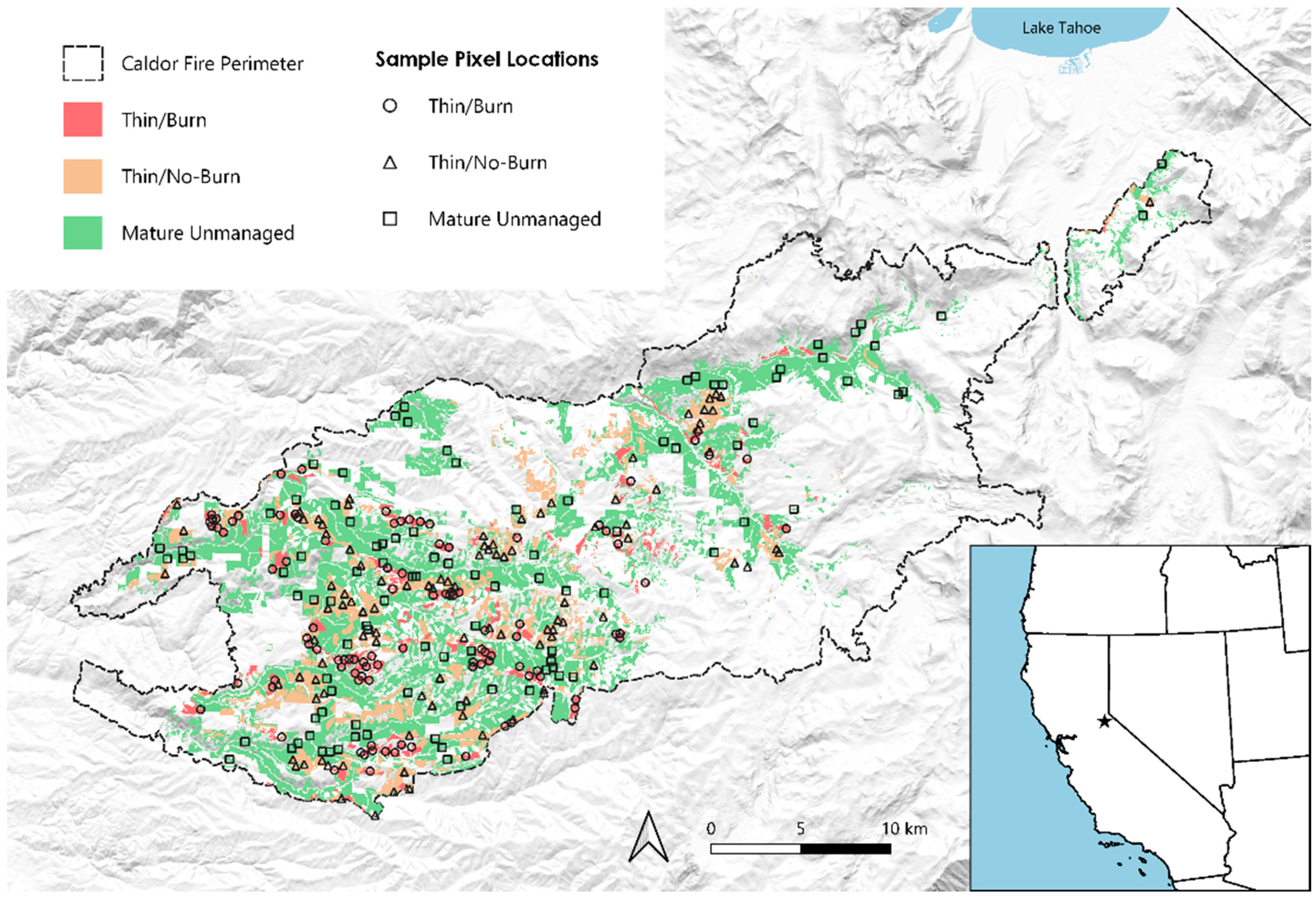
Figure 1. The Caldor Fire study area. Unshaded areas within the fire perimeter were either not the vegetation type we examined and/or were not managed by the U.S. Forest Service. The star in the overview map represents the approximate location of the fire.
Land 11 00995 g001
Figure 2. Sample pixel locations for each management category, with colors corresponding to RAVG fire severity categories (with the two lowest severity categories in the BA4 dataset combined into a single low category as described in the methods).
Land 11 00995 g002
Table 1. Fire severity (Caldor Fire only) and cumulative severity (mortality from commercial thinning and Caldor Fire), in terms of mean percent basal area mortality (and s.d.), for mature unmanaged forests (n = 100), commercial thinning with slash burning (n = 100), and commercial thinning with no slash burning (n = 100) in the Caldor Fire of 2021.
Severity MeasurementMature UnmanagedThin/BurnThin/No-Burn
Fire Severity Only56.0 (35.3)52.0 (33.5)51.0 (34.5)
Cumulative Severity56.0 (35.3)64.8 (24.5)64.0 (25.3)
Publisher’s Note: MDPI stays neutral with regard to jurisdictional claims in published maps and institutional affiliations.