1. Introduction
Since the late 19th century, urbanization has become a global process that has left a significant mark not only on urban areas, but also on rural areas. With the fast growth of rural–urban migration, the quantity and quality of rural labor has decreased, leading to shrinkage of rural communities and local economies, which is in contrast to the prosperity of urban growth. Rural decline has become a global issue and the majority of countries have either experienced or are experiencing rural decline [
1,
2]. Nevertheless, significant changes, sometimes called ‘rural restructuring’, driven by modernization and globalization, have taken place in many developed economies and turned the tide of rural decline to a certain extent [
3]. In the 1970s, repopulation and industrialization of the countryside were noted in many countries such as the UK, USA, and France [
4,
5]. The middle class moved to rural areas, producing a social environment that is distinct from the past. Farming was pushed to the margins of the rural economy from a position at the heart of rural life, with the shift of the rural economy from the primary industries to the secondary and tertiary sectors. Recently, similar changes have been observed in developing countries which are undergoing the process of rapid urbanization coupled with modernization and globalization [
6]. Although it remains doubtful whether these changes merit the designation of ‘restructuring’—as Hoggart and Paniagua suggested that “‘restructuring’ should embody major qualitative, and not just quantitative, change in social structures and practices” [
7]—they are distinguished by intensity, persistence, and integrity and have promoted the revival of rural areas [
3].
However, such changes are spatially selective and have taken place unevenly across regions [
3]. Owing to diversity in location, natural resources, community capacity and historical background, rural areas respond differently to urbanization, modernization, and globalization [
2]. Some areas are retooling by using their place-based assets to create new competitive advantage opportunities within the global economy while others lost economic and employment opportunities [
8]. Therefore, villages represent various functions [
9,
10]. The development of industry is an important indicator of the differentiated performance in villages, especially for developing countries undergoing the industrial transition from agriculture to manufacturing [
11,
12]. Once a village embarks upon the road to industrialization, new activities and functions will emerge, being attractive to the locals and newcomers and playing important roles in regional development [
12,
13]. Otherwise, they may be isolated and deserted, with only traditional activities and small populations.
Given the increasing prevalence and importance of industry in rural areas, several explanations have been proposed to explain rural industrialization, including the constrained location hypothesis, the production cost hypothesis, the filter-down hypothesis, the capital restructuring hypothesis, and the residential preference hypothesis [
3,
14,
15]. The regional disparity of rural industrialization has been noticed by some researchers [
11]. However, research on the rural industrial geography—the agglomeration pattern, for example—and its effects as well as influencing factors is limited, in comparison to that regarding urban industry [
16,
17,
18]. In fact, rural industry operates in an environment that is different from its urban counterpart [
19,
20,
21]. Firstly, urban industry is rooted in the economies of agglomeration, where enterprises can conveniently access services, market information, skilled labor, and intermediate product [
22]. By contrast, rural industry is rooted in the abundance of resources, providing low-cost production elements, including land, mineral, labor, and the like [
23]. Secondly, rural firms mainly serve the local market, which means the size of markets is smaller on average, but at the same time there may be less local competition [
24]. By contrast, urban firms are more engaged in a well-integrated and dense market with fierce competition [
19]. Thirdly, rural entrepreneurs are highly embedded in communities [
25]. In this way, rural industry is more dependent on social networks and capitals than urban ones [
26]. Given the differentiated environments mentioned above, the location strategy of rural firms differs from that of their urban counterparts [
22]. Accordingly, the conclusions derived from studies on urban industry cannot be generalized to rural industry without hesitation, and the geography of rural industry merits further exploration.
In this paper, we study the rural industrial geography of an ordinary county in China and attempts to make the following contributions to the literature. Firstly, rural industrial geography is situated into a hybrid process, an economic, institutional, and social process which is shaped jointly by the historical background and contemporary environment. On the one hand, rural industrialization is not only an issue of economic development, but also embedded deeply in local institutional and social milieus. On the other hand, the industrial development of a rural area depends not only on the current conditions, but also on foundations laid in the past. Secondly, we innovatively applied the methods of investigating urban systems, such as rank-size analysis and size classification to rural studies. In the process of rural industrialization and transformation, industries expand in some villages whereas they do not in others, leading to spatial dynamics of the rural industrial system. By introducing the methods of urban system research, we describe what the rural industrial system is like and what the similarities and differences are between the two systems. Thirdly, the rural industrial pattern is identified and understood by adopting a multi-level approach. The development of rural industry occurs and can be investigated simultaneously at county, township, and village levels. Therefore, on the one hand, the depiction of the spatial pattern of rural industry will be carried out at multiple levels; on the other hand, driving factors at multiple levels will be considered jointly to explain the development of rural industry. Finally, we choose an ordinary county in China as the case, which has undergone a considerable process of urbanization and industrialization over the past decades. The complex terrain, varying levels of development and diverse industrial structure across the county make it an ideal case study with great potential reference significance to rural industrial transformation in China and beyond. Plenty of field work and close cooperation with local governments enable us to collect abundant geographic and survey data to support this case study of an ordinary county of which regionwide village-level data are rarely available, especially in developing countries.
The remainder of the paper is organized as follows: a brief introduction to rural industrial development in post-reform China is provided in the next section. Afterwards, the study area, method, and data used in this study are introduced. We then present the results in the fourth section. Finally, we report the conclusions and discussions in the last section.
2. Rural Industrial Development in Post-Reform China: Practice and Research
Since the reform in 1978, China has undergone rapid urbanization coupled with rural industrialization. The growth of rural industry over the past four decades has attracted much attention from scholars, and the changes in rural industry throughout this time have driven the evolution of academic focus (
Table 1). At present, with the rural revitalization becoming the most important national strategy after targeted poverty alleviation, the development of rural industry has received great attention from academia and policy circles.
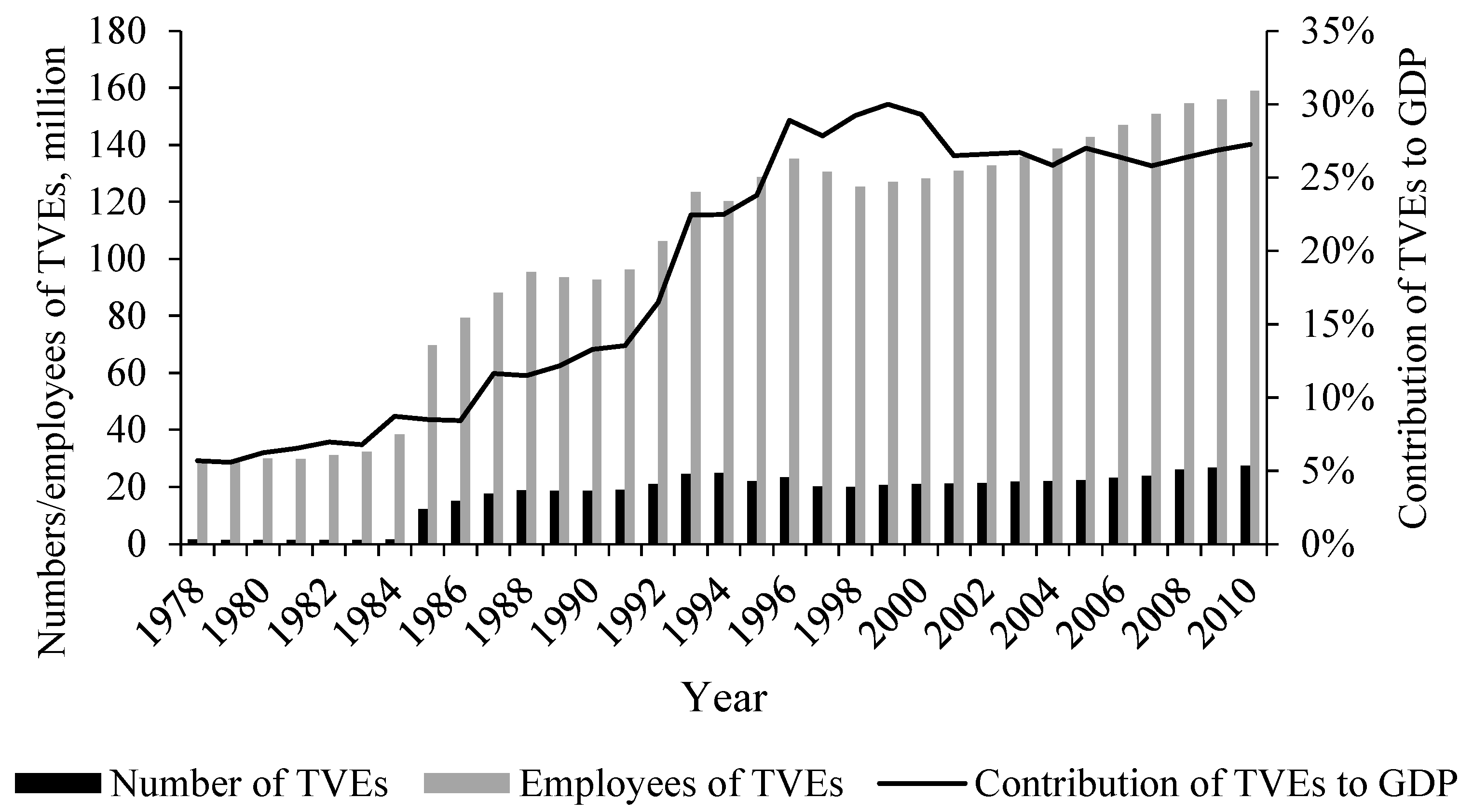
Since 1978, China has implemented economic reform. The household responsibility system in rural area greatly improved agricultural productivity and released a large number of labors from the farming sector. To provide jobs for agricultural surplus labor, township and village enterprises (TVEs)—mainly in the industrial sector—were widely established throughout the country. Thousands of peasants departed from farming without leaving native land, which drove rural industrialization to a large extent. In 1978, the added value of TVEs accounted for 5.66% of the GDP in China. By 1996, it reached 28.88% (
Figure 1). Since then, industry has continued to play a major role in rural China. It alleviated rural unemployment and increased the income of rural residents. In fact, TVEs in this period were small and dispersed. The average number of employees per enterprises is 5, and 92% of TVEs were located in numerous villages instead of town centers in 1992. The rapid growth of rural industry has attracted the attention of scholars. Research in this period focused mainly on the driven force, ownership, and performance of TVEs; as well as the role of local government in rural industrialization.
In the mid-1990s, as the Chinese economy became more market-oriented, TVEs faced increasingly intense competition. Consequently, rural China has experienced a rapid process of privatization, and a large number of collective enterprises owned by townships or villages transformed into private enterprises [
36]. In this period, rural industrialization slowed down. The number and employees of TVEs declined during 1997–1998, and the contribution of TVEs to GDP declined to 25.78% in 2007. Institutional transformation was the focus of research in this period. At the same time, researchers began to rethink the rural industrialization and blamed the dispersed spatial pattern for causing many problems. Firstly, TVEs occupied a large amount of cultivated land inefficiently in rural area [
37]. Secondly, infrastructures were overbuilt to accommodate the scattered enterprises. Thirdly, enterprises were too small and dispersed to benefit from economies of scale and agglomeration [
38]. Lastly, environmental monitoring and governance were difficult [
30]. Given the problems above, building industrial parks in townships to accommodate TVEs became popular. In 2007, 7760 industrial parks with 0.68 million enterprises had been built in rural China. It accelerated the agglomeration of rural industry to a certain extent.
Since the late 2000s, China’s economy has slowed down, and the limitations of extensive industrialization in the past have attracted the attention of policy makers and researchers [
39]. Many township industrial parks were criticized for their heavy pollution, low productivity, and waste of land resources [
40,
41]. As a result, the reorganization of industrial parks and TVEs began. Several small parks were closed, and enterprises in these areas were relocated to a new and large park. Additionally, some neighboring parks were merged into a large one. However, given the embeddedness of rural industry [
26], agglomerating most enterprises in one place is not feasible. Some TVEs tend to be located in proximity to owners’ homes in order to receive support from the social network. Besides, with the development of information and communication technologies, the geographical proximity to related enterprises is not as necessary as before in the development of rural industry [
42]. Consequently, some enterprises were still scattered in villages and some were integrated organically by a cooperation platform, but not geographically connected [
43].
At present, the context of rural industry is unprecedentedly complex. On the one hand, given that the economy of China is becoming market-oriented and slow-growing, competition is fiercer for rural industrial enterprises than ever before. In addition, due to the fear of the negative impact of extensive industrialization, which has caused lots of resource consumption and heavy environmental pollution in the past, the Chinese government has recently paid much more attention to resource conservation and environmental protection, thereby posing great challenges to rural industrial enterprises. On the other hand, the rural revitalization strategy—which has been implemented vigorously in China since 2017—has become the most important strategy of the country. Promoting industrial prosperity in rural areas is the focus of this strategy for its pioneering role in regional development [
44]. According to the national strategic planning of rural revitalization released in 2018, rural industrial enterprises are expected to receive formal loans and construction lands more easily and enjoy better infrastructures and services. Besides, the high price of land and labor makes urban areas less attractive to industry; hence, rural areas have become an alternative, thanks to the progressive improvement of infrastructure. Many industrial enterprises are moving to rural areas with their capital and technology, posing opportunities for the development of rural industry. Thus, the changing circumstances at home and abroad pose new challenges and opportunities for rural industry.
3. Case and Methods
3.1. Study Area
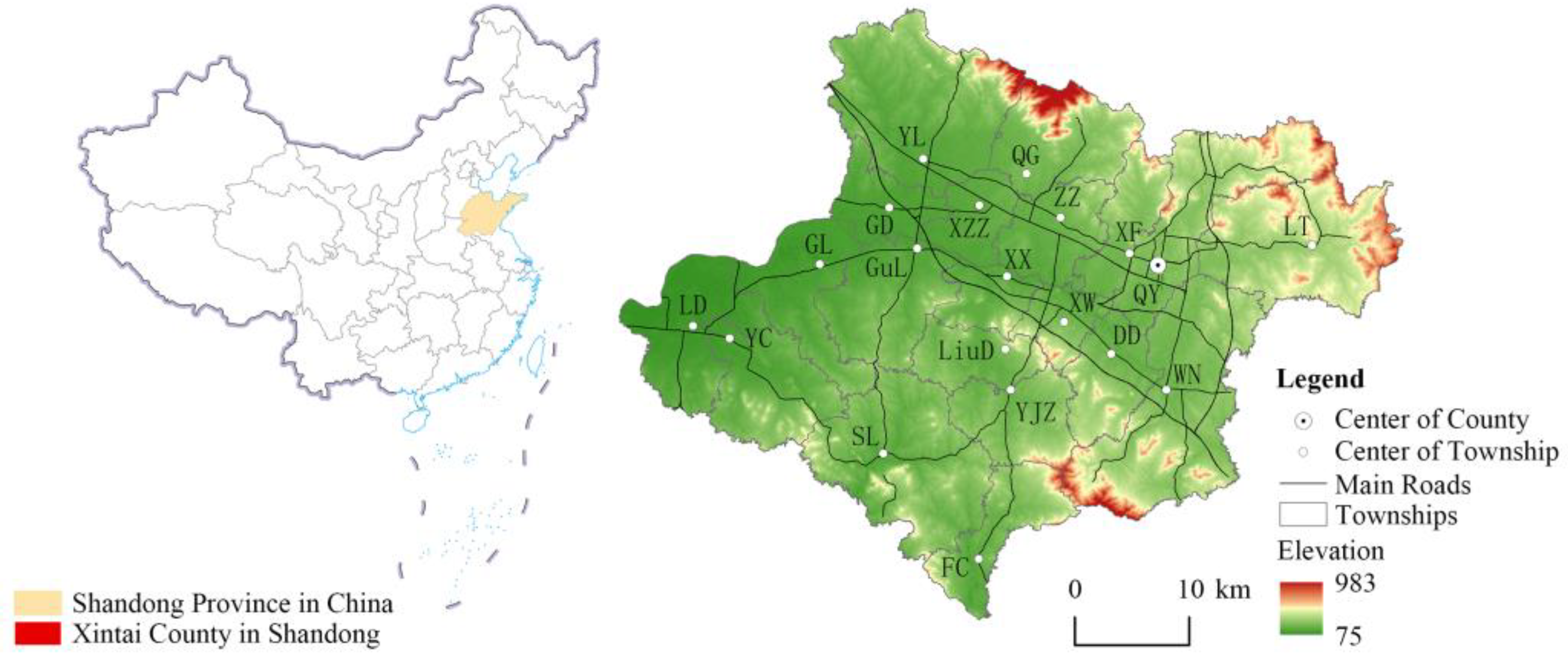
Xintai is a county-level city in Shandong Province, which is located in Northern China (
Figure 2). It has a varied topography including mountains, hills, plains, and lakes. The county is divided into 20 township-level units (hereinafter referred to as ‘township’), namely, Qingyun, Xinwen, Xinfu, Dongdu, Xiaoxie, Zhaizhen, Quangou, Yangliu, Guodu, Xizhangzhuang, Loude, Yucun, Gongli, Guli, Shilai, Fangcheng, Liudu, Wennan, Longting, and Yuejiazhuang. A total of 858 village-level units (hereinafter referred to as ‘village’) are under their jurisdiction. By the end of 2020, it is composed of approximately 1788 km
2 of land occupied by 1.27 million inhabitants. The proportion of industrial added value to GDP is 31%, and the urbanization rate is 58%. Both values are close to that of the whole country, which is 31% and 64%, respectively.
Owing to abundant coal resources, Xintai has become one of the main coal-producing counties in China. Industries closely related to coal—including energy, chemical, metallurgy, and machinery—play a leading role in Xintai. Coal mining began in Xintai in the early 1930s. However, at present, the depletion of coal resources in Xintai has triggered the restructuring of industry. The contribution of industry to GDP increased from 50.68% to 52.41% during 2000 to 2010, and drastically dropped to 31.02% in 2020.
With the economic reform, rural industry in Xintai has developed rapidly since the middle of 1980s. Building material, chemical, textile, and machinery enterprises have gradually grown in this period. In the late 1990s, Xintai began to build industrial parks in townships and promote the specialized development of industry. By the 21st century, most townships had established distinctive industries, such as glass in Guli and wool in Xizhanghuang.
Xintai was selected as a case study with general significance in this research for three reasons: (1) Xintai has undergone a considerable process of urbanization and industrialization over the past decades, which is in step with the global south, especially the developing countries in Asia and Africa. Thus, it is representative for the study of rural transformation under rapid urbanization. (2) The development of rural industry in Xintai was strongly influenced by local governments in the early stage and has been increasingly market-oriented since the reforms launched in the late 1970s, following a similar path to the rest of China, which allowed us to explore the hybrid process of rural industrialization with consideration of the role of government and market in transitional economies. (3) The complex terrain, varying levels of development, and diverse industrial structure across the county make it an ideal case study with great potential reference significance to rural industrial geography.
3.2. Methods
The main tasks of this study are as follows: Firstly, we describe the distribution of rural industry in the study area by means of rank-size analysis, size classification and kernel density estimation. Secondly, cluster analysis is performed for townships to identify their spatial patterns of industry. Lastly, regression models are estimated for villages to investigate the factors influencing the pattern of rural industry.
3.2.1. Size and Spatial Distribution
- (1)
Rank-size analysis
Rank-size analysis was used in this paper to summarize the size distribution of rural industry. It is a powerful instrument for describing the size distribution of unified systems and revealing the relationship between sizes and related ranks. According to Zipf’s law, the size distribution can be found by [
45]
or
where
is the rank of a village according to its size of industry;
is the industrial size of the village ranked
;
is the industrial size of the village ranked 1; and
is referred to as Zipf’s exponent. When
, the distribution of industry follows Zipf’s law. A smaller
indicates an even distribution of industry, whereas a larger
demonstrates disparities among villages.
- (2)
Size classification
To reveal the hierarchical features of rural industry, this paper divided villages into different classes according to the size of industry by using the method of natural breaks (Jenks). For each class, we calculated the number of villages as well as the size of industry.
- (3)
Kernel density estimation
This model was used to describe the spatial pattern of rural industry. The kernel density of a point is calculated by summing the density contribution of each point centered around it using the equation
where
is the kernel density value of the center point
;
is the number of points whose distance from the center point is no more than a specific bandwidth,
;
is the spatial weight function; and
is the squared Euclidean distance between the center point and point
. The denser the points, the higher the kernel density value is.
3.2.2. Spatial Pattern Recognition
At the township level, the cluster analysis—one of the most efficient methods to group observations in terms of their nearness or similarity—was used to identify the spatial pattern of rural industry. Firstly, an index system was constructed from perspectives of centricity, inequality, and spatial agglomeration, with two indicators in each category to represent the industrial patterns (
Table 2). The values of the six indicators were calculated and standardized with Z-score. Afterwards, systematic cluster analysis (Ward’s method) was used to determine how many township clusters should be selected and which values those townships clustered around.
3.2.3. Model Specification
- (1)
Model
To analyze the factors influencing the pattern of rural industry, we developed the following multiple liner regression model
where
is the dependent variable which indicates the size of industry in village
;
is the constant;
,
, and
represent the coefficients of the independent variables,
,
, and
respectively; and
is the residual term. The ordinary least squares method was operated to estimate the parameters.
- (2)
Independent variable
Previous studies have revealed that the pattern of industry is influenced by various factors, such as nature, economy, institution, and society. On the basis of the literature, we categorized independent variables into five groups, including resources, market accessibility, role of government, social capital, and the industrial pattern at the township level.
A. Resources
Resources, whether natural or humane, are the basic conditions for industrial development. The raw materials, fuels, and spaces for production come from nature. Therefore, industrial enterprises prefer locations with abundant resources, such as mineral and land. Typically, resource-oriented enterprises—such as mining, metallurgy, and agricultural products processing—tend to be close to origins of raw materials and fuels. As for human resources, the quantity and quality of labor force largely affect the cost and efficiency of industry. Overall, labor-intensive enterprises—such as textile industry—prefer locations with large amounts of cheap labor, whereas technology-intensive enterprises—such as IT—tend to be located in areas with a number of skilled labor. Four variables were included in this study to assess the impacts of natural and human resource on rural industry: coal (a dummy which equals 1 if there is coal, whether it is currently being mined or not, and 0 if not), land (the area of land with slope less than 5°, excluding water), NLabor (the number of people aged between 16 and 59), and QLabor (the percentage of the population with a college degree or above).
B. Market accessibility
With the deepening of the market-oriented reform in China, rural industry is increasingly dependent on the market. Rural industrial enterprises provide most products to outside consumers rather than local villagers. Besides, intermediate products are generally obtained from outside suppliers. Thus, market accessibility has become a critical factor in the location selection of industrial enterprises. In this study, market accessibility is measured by three variables: DNhighway (distance from the village to the national highway), DPhighway (distance from the village to the provincial highway), and DChighway (distance from the village to the county highway). These highways lead to different markets, near and far.
C. Role of government
In addition to the market, the development of industry in China has been continuously influenced by the governments at various administrative levels. Governments play an important role in the allocation of economic resources, and the seat of the government is not only the political center of the region, but also the economic center. Generally, villages close to the administrative center are more likely to have developed industry. Thus, two dummy variables, DCcenter (distance from the village to the county center) and DTcenter (distance from the village to the township center), were used for assessing the impact of the government’s role. We hypothesized that their effects are negative.
D. Social capital
China’s rural industry is mainly influenced by two types of social capital: clan and collective. Clans have a long history in China and affect rural industry in two ways. On the one hand, kinship networks offer benefit for rural enterprises by protecting private property rights, reducing transaction costs, and building bridges to market information [
46]. On the other hand, kinship networks increase the cost of raising resources and limits the market size of rural enterprises [
47,
48]. The collectivism originated from communist reforms. Even in the post-reform era, the collective organization exerts a continuing influence on China’s rural industrialization, which is mainly manifested in the collective economy. Therefore, we selected two variables to assess the impact of these two types of social capital:
Clan (proportion of the population with the largest surname in the village) and
Ceconomy (that equals 1 if there is collective economy in the village and 0 if not).
E. Township-level industrial distribution
The development of rural industry in a village depends not only on the factors of the village per se, but also on the spillover and competitive effects of industry in neighboring villages. Therefore, examining the impact of the industrial pattern at the higher level—that is, the township level—is necessary. The spatial pattern at the township level is identified by the cluster analysis mentioned above. Three dummies—PD, MA, and MD—were employed to capture villages that are located in a township where industry is monocentric and dispersed, polycentric and agglomerative, and polycentric and dispersed.
3.3. Data
The main dataset used in this study came from two sources, and they complemented each other. The first one was land use data derived from the third national land resource survey, the most credible land data in China. It provided information on the type, location, and area of every land patch, which allowed studies to be conducted in small units. The area of industrial land, including the mining land, was calculated for each township and village to indicate the size of industry.
The secondary dataset was derived from a face-to-face survey conducted in May 2021. All the interviewees of this survey were cadres familiar with their villages. The survey collected information regarding the population, economy, governance, and environment of 806 villages in Xintai. Some village-level units, mainly urban communities, were excluded from the survey and the following regression analysis as well. The main questions in the survey used in this paper were presented in
Appendix A (
Table A1).
In addition, some GIS data were used to calculate the slope and market accessibility. Specifically, the digital elevation model data were derived from the ASTER GDEM and the road vector data were obtained from Baidu Map.
Table 3 presents the descriptive statistics for all independent variables.
4. Results
4.1. Countywide Distribution of Rural Industry
Xintai has 4739.13 ha of industrial land, accounting for 2.65% of the total land. Given that the built-up areas of some townships and villages are continuous, we merged them and obtained 19 townships and 846 villages. On average, each village has 5.60 ha of industrial land, and 24.70% of the villages have no industrial land.
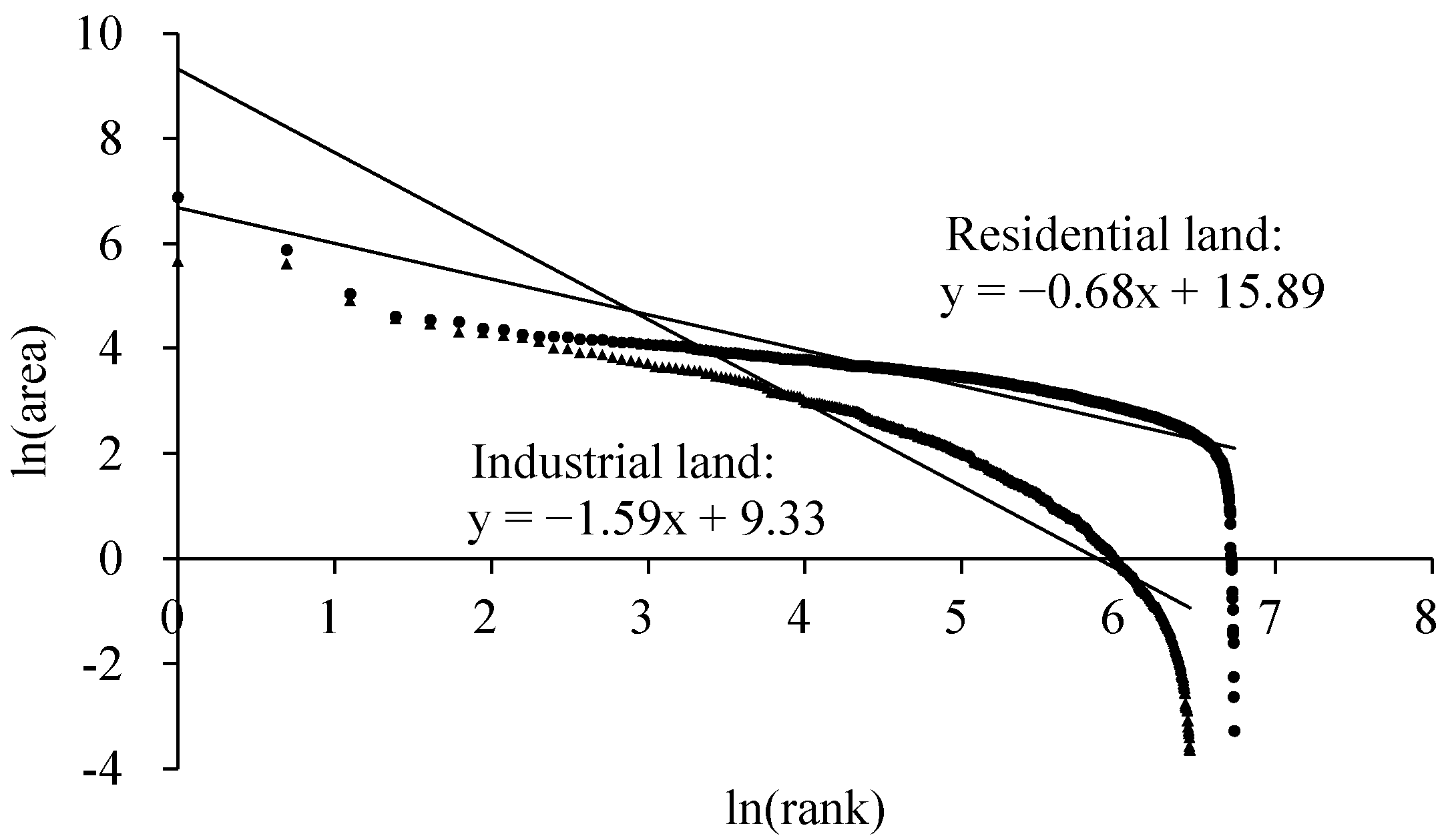
The distribution of rural industry in Xintai is unequal among villages, but the gap between the first and second ranked villages is small. To summarize the size distribution of rural industry in Xintai, we conducted a rank-size analysis for industrial land (
Figure 3). The results show that the Zipf’s index of industry is 1.59, which is higher than the critical value, 1, and the index of residential land, 0.68. Thus, even though the residential land is distributed evenly in Xintai, the industrial land is mainly located in several top-ranking villages and little industry land is found in the remaining units. Moreover, the sizes of industry in the first- and second-ranked villages are similar, which shows a polycentric pattern. The former has 6.09% of industrial land in Xintai, which is 1.05 times as much as the latter.
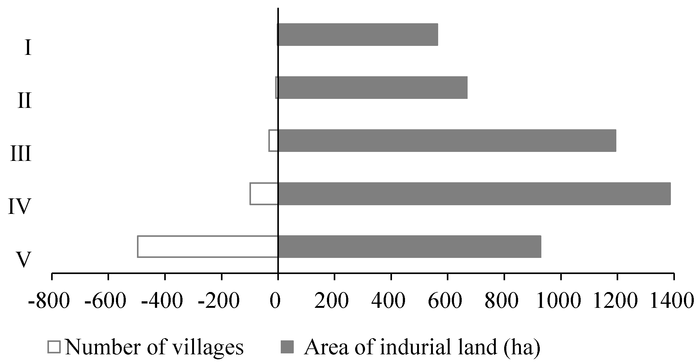
Villages with different sizes of industry are divided into five groups in a pyramid distribution. To reveal the hierarchical features of rural industry, we classified villages by using the method of natural breaks (
Figure 4). The results show that the larger the industry, the less the number of villages is. Specifically, the group with the largest industry contains two villages. They are industrial centers of the county and the total area of industrial land they have is 563.52 ha. The group with the second largest industry has eight villages. They are industrial sub-centers of the county and the total area of industrial land they have is 667.29 ha. The third group has 32 villages with a total industrial land area of 1193.77 ha and they are industrial centers of the township. The fourth group has 99 villages with a total industrial land area of 1386.43 ha, and they are industrial sub-centers of the township. The remaining 496 villages with a total industrial land area of 928.72 ha are divided into the last group.
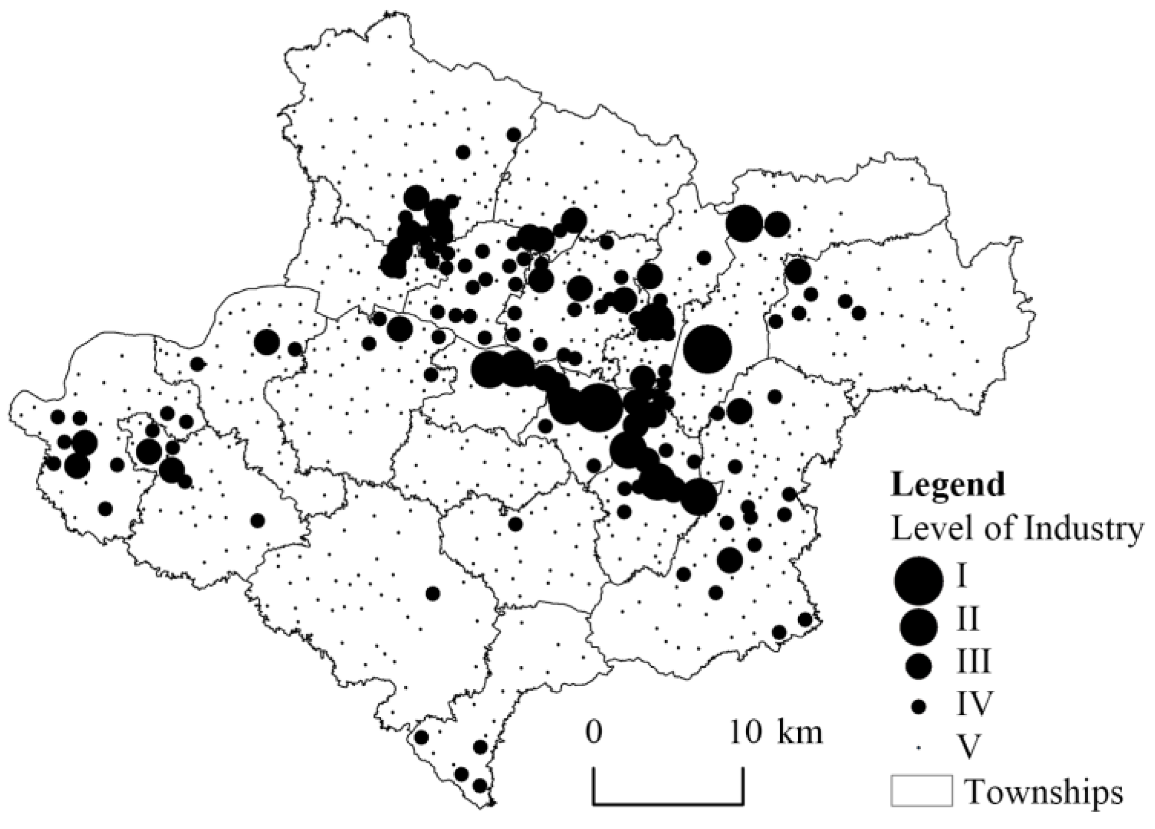
The industrial centers and sub-centers are dispersed across Xintai. The distribution is affected by the location of administrative centers at the county and township levels. As is shown in
Figure 5, the first-tier industrial villages are located near the county government. The second-tier industrial villages are either arranged around the first-tier ones, or are located near the township governments close to the county center. Villages with the third-tier industrial villages are either arranged around the second-tier ones, or are located near the township governments far from the county center. The rest may be deduced by analogy.
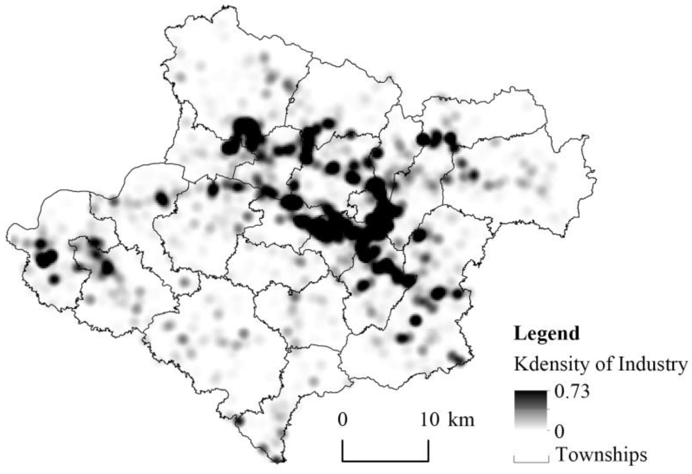
The spatial pattern of industry in Xintai can be summarized as ‘one core and two bands’. Kernel density estimation with a bandwidth of 1000 m was used to describe the spatial pattern.
Figure 6 illustrates the results. The central industrial area is formed by three townships in the east of Xintai—namely, Qingyun-Xinfu, Xinwen and Dongdu. The first banded industrial area, from the southeast to the west of Xintai, consists of eight townships—namely, Wennan, Dongdu, Xinwen, Xiaoxie, Guli, Gongli, Yucun, and Loude. The second banded industrial area is located in the north of the former one, involving four townships: Qingyun-Xinfu, Zhaizhen, Xizhangzhuang, and Yangliu.
The spatial industrial pattern of Xintai is closely related to the location of administrative centers, traffic arteries, and coal mines. Firstly, most industrial centers and sub-centers are located at the government residents at all levels. Secondly, the pattern of industrial area is in line with the pattern of traffic arteries. In particular, national road No. 342 passes through Wennan, Dongdu, Xinwen, Xiaoxie, Guli, Gongli, and Loude, where the first banded industrial area is located. Provincial road No. 241 passes through Qingyun-Xinfu, Zhaizhen, Xizhuangzhuang, and Yangliu, where the second banded industrial area is located. Lastly, in areas rich in coal resources—such as Xinwen, Xiaoxie, and Xizhangzhuang—industrial land is dense.
4.2. Diverse Spatial Patterns of Rural Industry within Townships
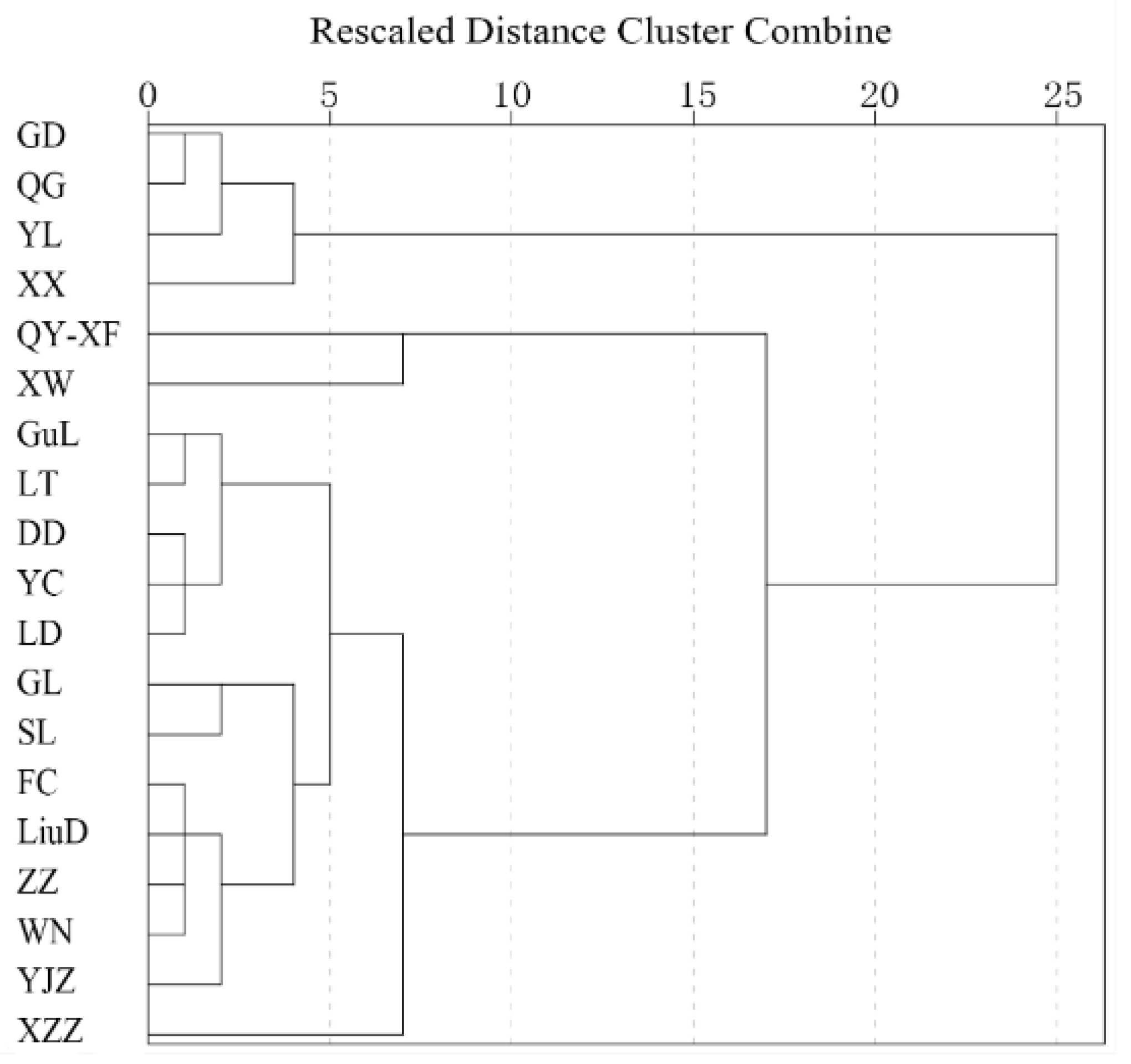
The spatial pattern of industry is different among townships in Xintai. To classify these patterns, we calculated six indicators mentioned in
Table 2 for 19 townships and performed a cluster analysis for them. The hierarchical clustering results were visualized in a dendrogram, which shows how individual observations were combined into groups of two, and subsequently into larger groups (
Figure 7). It allowed us to aggregate the townships into three clusters, revealing distinct spatial patterns of industry. The first cluster is composed of Guodu, Quangou, Yangliu, and Xiaoxie. The second one is composed of Qingyun-Xinfu and Xinwen. The third one includes the remaining 13 townships.
On the basis of the results of hierarchical cluster analysis, we identified centers of the three clusters and named them accordingly (
Table 4).
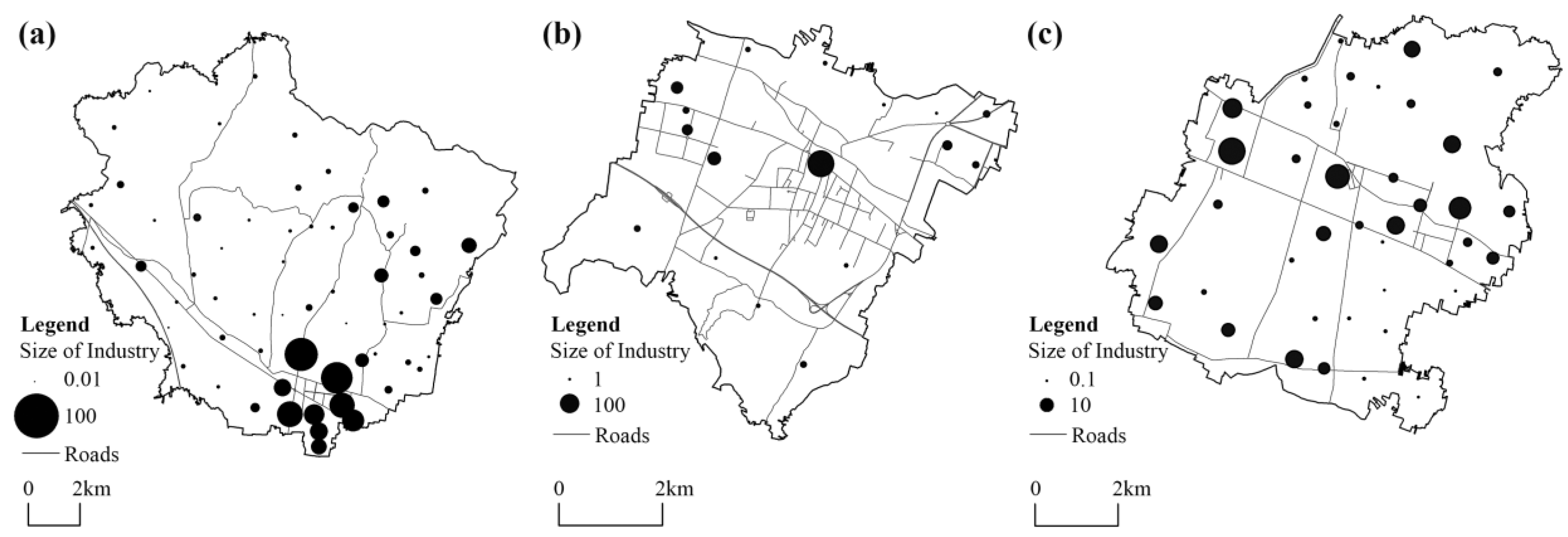
Townships in the first cluster are characterized by high concentration as well as low primacy, eccentricity, and dispersity. Thus, the industrial pattern in such townships is polycentric and agglomerative (labeled PA). Specifically, these towns have an industrial center surrounded by multiple sub-centers. The center and sub-centers, with similar sizes and close locations, form a large industrial agglomeration area. Yangliu is a typical example of the PA pattern (
Figure 8a). It is a large town with 91 villages. The industry in Yangliu is mainly located in several villages such as Gouxi, Dongzhangjiazhuang, Lixinzhuang, and Guanlu; accounting for 16.33%, 14.52%, 9.43%, and 9.29% of the whole township, respectively. In the villages outside the agglomeration area, industrial land is small.
Townships in the second cluster are associated with high importance, primacy, and eccentricity, which means that industrial land in such townships is monocentric and dispersed (labeled MD). Industrial enterprises are mainly located in the administrative center of the township, whereas villages outside the center have little industry. Taking Xinwen as an example (
Figure 8b), the area of industrial land in the central village accounts for 48.71% of the whole township, which is 4.10 times that of the second-ranked village. Furthermore, industry is small and scattered on the periphery.
Townships in the last cluster are similar with the MD ones for the low values of peripheral concentration and high values of eccentricity as well as dispersity. However, their importance and primacy are very low. Hence, we labeled them PD (polycentric and dispersed). It is the most common pattern in Xintai. Industrial enterprises are scattered all over the township, and the importance of the central village is weak. We take Zhaizhen as an example (
Figure 8c). The industrial area of the central village accounts for only 13.06% of the township, which is 1.24 times that of the second-ranked village and 1.53 times that of the third-ranked village. Therefore, large industrial agglomeration area has not yet formed.
Generally, rural industry is polycentric and dispersed at the level of township given that the PD pattern is the most popular one among townships. This finding is consistent with the results of previous studies. Nevertheless, some townships are exceptions for some reasons. Industry in Yangliu is agglomerative and is mainly located in the southern area. This is partly because mountains and hills are found in the north and west of the township, making it unfavorable for industrial production. Xinwen shows a monocentric pattern of industry due to the strong attractiveness of the first village, which is not only the administrative center of the township but also the center of the former Xinwen County in the past years.
4.3. Factors Shaping Rural Industrial Geography
Multiple factors—including resources, market accessibility, role of government, social capital, and township-level industrial distribution—were tested to explain the pattern of rural industry. Firstly, five simple multiple linear regression models were built, each of which includes one category of independent variables (Model 1–5). Secondly, all the independent variables were included in the full model (Model 6).
Table 5 presents the results for the models.
Resources play a leading role in rural industrialization, which explains 17.2% of the variance in industrial size (Model 1). Among the four variables, Coal has a positive effect on the pattern of industry. On average, villages with coal mines have 4.341 ha more industrial land than the others after controlling for other variables (Model 6). Coal mines are the main energy in the early stage of industrialization. Therefore, villages with coal resources started industrialization earlier than their counterparts. Although many villages have stopped mining due to the depletion of coals, the early industries related to coal—such as energy, steel, chemicals, and construction materials—have laid the foundation for later enterprises. Expectedly, the coefficient of land is positive, suggesting that villages with abundant land resources are more likely to have a large industry. In terms of human resources, the quantity of labor affects the size of rural industry significantly. As expected, greater quantity of labor is associated with larger industry. However, the quality of labor does not have a similar effect. The results imply that rural industry is labor-intensive instead of technology-intensive. Therefore, they show no preference for locations with skilled labor.
The impact of market accessibility on rural industry is second only to resources, and the 10.9% of the variance in industrial size can be explained by variables of market accessibility (Model 2). The coefficients of DNhighway, DPhighway, and DChighway are all negative. Thus, industry size decreases with the increase in distance to highways. The coefficient of DChighway is the smallest, and the coefficients of DPhighway is the largest. However, the difference among them is not significant. Therefore, rural industry depends on markets near and far.
Regarding variables related to the role of government, the coefficient of DCcenter is negative. It indicates that villages that are close to the administrative center of the county are more likely to have a large industry for the reason that public infrastructures and services are mainly located in the administrative center of the county, which has improved the conditions for industrial production. The results also suggest a similar effect of the township center. However, the coefficient of DTcenter is not significant when other variables are controlled.
For the variables of social capital, the coefficient of
Ceconomy is positive, indicating that the collective economy plays an important role in rural industrialization even in the post-reform era. Nevertheless, the size of kinship networks seems to have a negative impact on rural industry. The larger the kinship networks, the smaller the scale of industry is in a village. In fact, a close kinship network in a village often means a low level of openness and limited connection with the outer world which can be reasonably negatively correlated with industrial development. To test this hypothesis, we added a control variable—
Migrants (the number of people who are living but not registered in the village)—into the Model 6. The results show that coefficients of variables are robust except for
Clan which changes from −0.030 to −0.025 and is no longer significant at the 0.1 level. Therefore, we cannot conclude that the kinship network hinders the development of rural industry. A more possible scenario is that when rural areas open the door actively or passively to industrial investment, their communication with the outside inevitably becomes a comprehensive process manifested by population flows, market integration, information exchange, cultural transition, and social network diversification. As studies have shown, kinship networks help to protect private property rights, reduce transaction costs, and build bridges to market information, while increasing the cost of raising resources and limiting the size of market [
35,
36,
37]. In the industrializing era, collective economy has continued to play an important role in rural development, whereas traditional social capital of villages has been replaced by more diversified social networks with increasing connection with the outer world. Unveiling this transition, revisiting the pros and cons of kinship networks and investigating their association with rural industrial development merit much more academic enquiry, though these aims go beyond the scope of this paper.
The township-level industrial distribution has significant influence on the size of rural industry. Villages in townships with a PA pattern have larger-scale industry than that in townships with a PD or MD pattern. With a PA pattern, industry is mainly located in neighboring villages instead of being concentrated in a village or scattered all over the township. It prevents the problems of over-crowding and over-pollution while allowing enterprises to benefit from agglomeration economies.
5. Conclusions
The rapidly urbanizing global south have witnessed drastic changes in rural transformation in which industrial dynamics have played a fundamental role. Given that rural industry operates in an environment that is different from its urban counterpart, it is meaningful to explore the rural industrial geography specifically. In this study, rural industrial geography is situated into a hybrid process, an economic, institutional, and social process which is shaped jointly by historical background and contemporary environment. Taking an ordinary county in China—Xintai—as an example and drawing on the method of urban system research, this paper depicts the spatial pattern of rural industry at multiple levels. Furthermore, driving factors at multiple levels are considered jointly to explain the rural industrial geography. Our research presents several findings:
Firstly, the process of rural industrialization is uneven across Xintai, which is reflected in the pyramid size structure and the spatial pattern of ‘one core and two bands‘. As for the size structure, the larger the industry, the less the number of villages is. In terms of spatial pattern, the distribution of industry in Xintai can be summarized as ‘one core and two bands‘. Specifically, the location of industrial centers is highly related to administrative centers; the scope of industrial-intensive region is consistent with the mining area; and the direction of the industrial-intensive bands are in line with the direction of traffic arteries.
Secondly, rural industry is polycentric and dispersed not only at the county level but also at the township level. At the county level, the industry is not highly concentrated in one village. Instead, the primacy is low, and several centers and subcenters of industry with similar sizes are dispersed across the county. At the township level, the polycentric and dispersed pattern is the most popular pattern. More than two-thirds of townships show this pattern, which is characterized by low values of importance, primacy, and concentration; and high values of eccentricity and dispersity.
Finally, as demonstrated by its driving forces among which resources have continued to play a critical role in shaping the industrial geography, Xintai is in the early stage of rural industrialization. The resources of a village—including coal mines, land, and labor— have the greatest impact on the size of industry. The impact of market accessibility, both near and far, follows. The influence of institutional and social factors is notable as well. Villages that are close to the county center stand out in the process of rural industrialization and the collective economy has a positive effect on the growth of rural industry. Furthermore, the PA pattern at the township level is proven to be the best for the industrial development in villages, because it allows enterprises to enjoy an agglomeration of economies while avoiding the problems of crowding and pollution.
Despite the growing importance of industry in the economy, the current changes in rural China are different from those seen in Europe in the 1970s, which is sometimes called ‘rural restructuring’. China is still in the process of industrialization, and has not yet observed the urban–rural shift of industry, and the development of rural industry is largely spontaneous and thus dispersed [
34]. On the contrary, rural industrialization in Europe is often associated with broader deindustrialization at the level of national economy [
5]. In fact, many of the issues facing rural China today are similar to those found in rural Europe after the Second World War [
49]. This implies that rural development in China, and possibly other developing countries, has to a great extent followed the trajectory of developed countries and there may be global tendencies in rural changes.
6. Discussion
This article contributes to the literature in at least three aspects. Firstly, rural industrial geography is identified and understood from a multi-level perspective which is different from the existing studies and has several advances [
34,
50]. The distribution pattern of rural industry is examined at different levels and the conclusion that rural industry is polycentric and dispersed holds simultaneously at the county and township levels, which means that efforts to promote the agglomeration of rural industry should be made by not only the county government, but also township governments. Influencing factors at the village and township level are both considered when explaining the pattern of rural industry. It is meaningful given the fact that the village is not an isolated system and is increasingly engaging with the economic processes of a broader region.
Secondly, the results reveal the similarities and differences between urban industry and rural industry that have not been adequately addressed before. Agglomeration economies are important not only for urban industrial enterprises, but also for rural ones [
34]. As the results of this study demonstrate, an agglomerative pattern of rural industry in the township is helpful for the growth of rural industry in villages. However, rural industry is not as agglomerative as urban industry given its special properties. On the one hand, rural industry relies heavily on resources such as land and labor [
23], which are usually scattered in rural areas. On the other hand, rural enterprises are highly embedded in communities and are affected by local governments and collective organizations in China [
51,
52], which tend to promote rural industrialization within their jurisdiction.
Thirdly, by examining the differentiated industrial patterns among townships, this paper reminds us to respect the varied backgrounds when taking measures to promote the agglomeration of rural industry. Policies should be more localized. For example, townships with an MD pattern should encourage enterprises to concentrate in or around the center of the township by constructing an attractive township-level industrial park. Local governments must provide sufficient land, good infrastructure, and favorable policy for enterprises. As for townships with a PD pattern, the current centers of industry are similar in size and far from one another, which makes clustering enterprises in one place difficult. Consequently, several industrial centers could be retained to attract surrounding enterprises, and a unified cooperation platform should be established to improve the connection and division of work among the centers.
Although this study focused mainly on the rural industry geography in Xintai, China, it has general value for the development of rural industry beyond China. First, the rapidly urbanizing global south has witnessed drastic changes in rural areas in which rural societies reduce their reliance on agriculture. Thus, industry is playing an increasingly important role in the rural economy. However, the process of rural industrialization is uneven across regions. The exploration as to why some villages embark upon the road to industrialization while others do not not only shows the way for promoting transformation development in rural China, but it also provides useful reference for other developing countries. Second, the decentralized and polycentric features of rural industry are widespread, as are the problems that they cause—such as heavy pollution, low productivity, and waste of land resources. The case of Xintai is not unique, but a microcosm of many regions in developing countries. Thus, an examination of the spatial pattern and driving forces of rural industrial geography in Xintai should, therefore, provide useful references for other developing countries in optimizing the spatial distribution of rural industries. Third, by examining the spatial disparity of rural industry, this paper reminds us to situate rural geography into a hybrid process of economic, institutional, and social development. The fact that rural industry is embedded deeply in local institutional and social milieus deserves more scholarly attention in future study. Given the differentiated institutional and social environment of rural industry, studies and policies in this field should adopt a more localized approach.
This paper has some shortcomings to overcome in future studies. On the one hand, given the cross-sectional design, we can only examine the current situation of the rural industrial geography in the study area with little information on its past and future. Future studies with a cross-temporal approach are needed to examine the evolutionary process and long-term trend of the changing rural industrial geography. On the other hand, the decision-making process of rural entrepreneurs should be considered, given rural industrial geography is—to a great extent—the outcome of their location decisions. Unfortunately, only data from land surveys and rural surveys are currently available to us. Therefore, we know very little about the decision-making process of rural entrepreneurs and how factors, such as kinship networks, affect the development of rural industry. In-depth interviews with rural entrepreneurs are needed in future studies.


