Abstract
Wood and charcoal were key sources of energy during early industrialization in Europe (18th century), preceding the large-scale exploitation of fossil coal. Past timber harvesting implied land transformation and woodland resources management. Therefore, relict charcoal kilns and historical documents of forest management are important sources of information about past woodland composition and structure. However, ancient charcoal kilns are poorly documented in temperate woodlands in the lowlands of western Europe, especially combined with historical written sources. In this study, charcoal production was investigated in an area in NE France, by combining charcoal and historical sources analysis, along with innovative dating methodologies. Thus, by using both radiocarbon and optically-stimulated luminescence dating, we showed that the activity lasted until recent times (19th–early 20th centuries) and Carpinus was the dominant taxon in charcoal assemblage. Moreover, kiln attributes seemed to be independent of topographical variables. Woodlands in this area were subject to a coppice-with-standards management, where small diameter wood was preferred to produce charcoal and large diameter stems, mainly Quercus and Fagus, were traded as timber. The dominance of Carpinus is rather uncommon in charcoal studies but supports the importance of Carpinus as fuelwood since the Middle Ages, as confirmed by many written sources.
1. Introduction
Before the large-scale use of fossil fuels in the 19th and 20th centuries [1], wood was the most important source of energy, both for domestic (cooking, heating) and (semi-) industrial (glass and metal production) activities [2]. The production of charcoal, essential for metal smelting, was widespread in woodlands all over Europe, beginning from the Middle Ages [3,4,5,6,7,8], and peaked during early industrialization with growing volumes of iron production [9]. The use of charcoal in Europe was gradually replaced by fossil coal during the second half of the 18th and early 19th century. As a result, charcoal production became residual on the verge of the 20th century in developed countries, but numerous archaeological remains of this activity can still be found today, especially in historical woodlands [3].
The technology of charcoal production has faced some changes over time [4], with a shift from pit kilns [5,6] to mound kilns around 1300 CE. From the Late Middle Ages onwards, charcoal production was performed above ground, where stacks of wood were positioned to build a mound kiln on a levelled and stable surface in order to sustain the woodpile [4,7,8], particularly in areas with relief. In the process of charcoal production in mound kilns, logs of variable diameter were stacked around a chimney and covered by earth, mud and/or plant material to control the oxygen level to perform pyrolysis (incomplete wood combustion) for several days [7,9]. After charcoal harvesting, charcoal fragments and ash, the remnants of charcoal production, lay on-site, forming a dark (black greyish) soil horizon of variable dimensions [10,11]. Charcoal production platforms could be used several times by the charcoal maker in the same season of production and over several years, even though these reuses are hard to identify and to quantify [10].
The quantification of charcoal production sites is key to assessing former impacts in woodlands, and several studies [12,13,14,15] have attempted to achieve a more comprehensive inventory of charcoal kilns. Some sources [7,16] indicate that woodland areas influenced by wood harvesting for a single charcoal kiln covered circa 100 m around the kiln. Remote-sensing data (e.g., Light Detection and Ranging, LiDAR) have been tested to estimate the surface affected by this activity [17]. The content of the charcoal layer is considered to be a product of locally harvested wood [18,19] and, thus, reflects past dynamics of forest ecosystems. Indeed, forest woodland composition has changed through time, in part due to its exploitation for timber and firewood. Evidence of different management regimes can be assessed, for instance through tree-ring analysis [20,21] or archival data [22]. Coppicing was a common practice for continuous wood supply in the pre- and early industrial period in Europe [23]. Coppicing became less significant from the late 19th century onwards, shifting to a high forest management regime [24] due to the decreasing demand for fuelwood [25]. Coppice management consists of the harvesting of shoots resprouting from stumps under a short rotation period [26,27]. Coppicing could be implemented as the sole management regime of a forest stand, or as coppice-with-standards, where coppice trees, which were mainly used for the production of fuelwood, were combined with standards (single-stem trees) to produce timber [28,29]. However, despite the extensive description of such historical woodland management practices, mostly through written historical sources [22,30], they remain poorly documented based on paleo-botanical data, especially for the temperate lowland areas in NW Europe.
In this study, we investigated woodland exploitation for charcoal production in the temperate lowlands of northeastern France (Meuse Department), by combining both charcoal and archival data to better understand former woodland structure and composition. We aimed to (1) characterize the charcoal kiln patterns according to socio-environmental and morphometric variables and then evaluate (2) which taxa were used, (3) how dendrological characteristics can inform us about the original state of the wood, and (4) when this activity took place.
2. Materials and Methods
2.1. Study Area
Our study area is located in a temperate lowland area in northeast France (Grand-Est region). The area investigated covers a total of 57 km2, with three woodlands on topographical plateaus and small stream valleys, separated by large agricultural valleys. The area ranges from 260 m above sea level (a.s.l.) at the bottom of the wide valleys to 410 m a.s.l. on the plateaus (Figure 1). The substrate of the eastern plateau is composed of sedimentary bedrock with limestone, while it is ferruginous sandstone on the western plateau [31]. On the plateaus, soils are mainly loamy-clay, with local patches of hydromorphic conditions on the most clay-rich soils, and sand on the sandstone substrate (RRP-GrandEst 2020). In small stream valleys, soils present the accumulation of calcareous colluvium, sometimes locally rich in stones (RRP-GrandEst 2020). The mean annual temperature and precipitation is 9.8 °C and 694 mm, respectively, with a semi-continental climate (Bar-le-Duc meteorological station, [32]). The area is covered by deciduous broad-leaved woodlands, dominated by beech stands (Fagus sylvatica) and mixed forests with oak (Quercus spp.) and hornbeam (Carpinus betulus) among others [33]. The woodlands are owned either by the State, municipalities, or are privately owned.
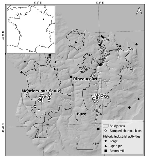
Figure 1.
Location of the study area in mainland France (square). The study area on a LiDAR-derived hillshade image is outlined by a full black line (corresponding to woodlands), and the sampling points for charcoal analysis and reference to historic industrial activities (forges, open pits for ore extraction and stamp mills) are indicated.
2.2. Characterization of the Sampled Kilns
Sample collection covered an area of 115 ha in total (44 ha on the west and 71 ha on the eastern side) with different slopes (ranging from flat to steep areas), exposure, altitude and property regimes. In a previous study, an inventory of kilns in the study area was carried out using high-resolution LiDAR images [12]. Using this inventory, randomly selected charcoal kilns were sampled according to the local density. A total of 48 charcoal kilns were sampled, 22 on the eastern plateau and 26 on the western plateau.
In the field, each time a charcoal kiln was found, the geographic position was recorded using a GPS device. For each charcoal kiln sampled, minimum and maximum diameters were recorded, corresponding to the surface limits of the kiln, assessed by the presence of the charcoal layer (a mix of charcoal, ashes and soil). This is especially relevant in flat areas where the boundaries can be highly diffused. The depth of the charcoal layer within the kiln was also measured, using a soil auger at three different points with a minimal distance of one meter between each point, in order to calculate the average thickness of the layer and avoid infra-local biases.
Variables were measured in loco (width, length and charcoal layer depth), calculated (area) or acquired from the Digital Elevation Model with the Zonal Statistics tool in QGIS 3.10 (mean and standard deviation in elevation and slope) [34]. We first defined a topology of charcoal kilns according to local socio-environmental and morphological features. Then, the Euclidean distance between kilns was computed based on the mentioned variables, and a hierarchical clustering was built based on the Ward method. Finally, we performed a principal component analysis (PCA) on the same variables, to (i) identify the topographical and morphological parameters that explain the identified clusters and (ii) determine whether these parameters are related to other descriptive variables (ownership, forest dominant species, geochemistry, aspect/exposure).
2.3. Anthracological Sampling
Charcoal sampling was designed following Ludemann and Nelle [35] and Knapp et al. [36]. We dug pits in the platforms in five positions (separated by a minimum distance of one meter), two pits in the center (with the codes “a” and “b”) and three pits on the downhill slope (with the codes “c”, “d” and “e”), of approximate dimensions 30 × 30 cm and 15 cm depth. We counted 30 handpicked charcoal fragments in each sample (i.e., each sampling pit), so each charcoal kiln produced 150 fragments to analyze. This strategy was implemented in order to investigate possible variations in the charcoal diversity within the platforms and assess the level of reproducibility of the sampling protocol.
The analysis focused on species composition and only the dominant species (frequency >2%) were considered, based on the subsample datasets. First, a factorial correspondence analysis (COA) was computed on the 238 subsamples to assess whether species composition or structure differed according to the subsample. Several community structure indices (Shannon–Wiener diversity, Pielou Evenness, Simpson’ Dominance, Species Richness and proportion of the dominant taxa) were calculated and differences between subsamples for all kilns were assessed with an Anova (after checking for normality and homoscedasticity). Second, the COA was performed on log(N+1) abundance per kiln to avoid overweighting by abundant species. Finally, co-structure between species composition and abiotic parameters was assessed by a co-inertia (CoI) analysis followed by a permutation test [37]. All analyses were performed with RStudio version 1.1.463, with R version 3.6.3 [38,39]. Multivariate analyses (PCA, COA, CoI) were performed with the ade4 package [40].
2.4. Anthracological Analyses
Taxonomic identification of charcoal fragments relied on the observation of three diagnostic sections, cross, radial and tangential, under a stereomicroscope (Zeiss Stemi 508, magnification 6.3–50×) and a reflected-light microscope (Olympus BX53M, magnification 40–500×). We compared the results with both wood anatomy atlases (e.g., [41]) and the reference collection of charred woods of the LIEC (University of Lorraine, Metz, France). Taxonomic determination was possible, at least to the genus level, except in some fragments of Salix and Populus, where the identification was not conclusive and they were grouped as Salix/Populus. When the identification could not be fully confirmed, the fragments were labeled as “cf.”, and each time diagnostic characters could not be entirely observed due to the poor preservation state of the charcoal fragment or anatomy alteration, the identification was assigned as “Undetermined”.
Along with the taxonomic determination, a set of morphometric, dendrological and taphonomical data was recorded [42]. Initial dimensions of the charcoal fragments, tree-ring curvature, number of tree-rings, presence of pith and/or bark and other characteristics (e.g., presence of narrow latewood in Quercus) were recorded. The diameter of charcoal fragments was estimated each time the fragment was suitable for analysis, i.e., excluding charcoal fragments where the rings were not visible, or their anatomy was altered due to poor preservation. A semi-quantitative approach was used, with charcoal fragments diameters allocated to five size classes (<2, 2−3, 3−5, 5−10 and >10 cm, e.g., [19,43]). This method of diameter estimation was preferred to other approaches [42,44] due to its efficient implementation during charcoal taxonomic identification.
2.5. Chronology Assessment
A set of 18 charcoal fragments from different charcoal kilns were selected for radiocarbon dating. In the absence of suitable fragments from fast-growing taxa, the presence of strong tree-ring curvature (twigs or small branches) and/or bark was preferred to avoid dating the inner parts of the original stem which might cause an old-wood effect. The analyses were performed by Accelerator Mass Spectrometry (AMS) in the Poznań Radiocarbon Laboratory in Poland. The results were calibrated with OxCal 4.2 [45] using the IntCal20 atmospheric curve [46] and expressed as Cal CE (Common Era).
Additionally, a set of kilns were sampled to explore the potential of Optically Stimulated Luminescence (OSL) [47] dating for the age determination of charcoal kilns. OSL dates refer to the time that has elapsed between the zeroing event in the past (in this case, heat exposure of the underlying sediment), and the time of sampling and analysis (2020 CE). In each selected kiln, a hand-made pit was dug (c. 50 × 50 cm until reaching bedrock) in the center of the platforms and the samples were recovered from the freshly opened profile using sampling tubes (5 cm diameter, 15 cm long). OSL dates were obtained as outlined by Karimi et al. [47] and involved equivalent dose determination using sand-sized quartz and the single-aliquot regenerative dose protocol [48,49]. Dose rates were derived from the specific radionuclide activities as obtained through gamma-ray spectrometry [50].
2.6. Study of Historical Written Sources
We analyzed documents deposited in departmental archives, and the data from written sources was incorporated with other quantitative data collected in our study [51]. We used two distinct historical forestry registers. One recorded all forestry operations in the State woodlands in and around our study sites at the end of the 18th Century (Archives Départementales de la Meuse, Bp 6004, Procès-verbaux de l’assiette des taillis, marques des arbres et adjudication des glandées, 1781−1790). The other register recorded equivalent operations in Communal forests (Archives Départementales de la Meuse, Bp 6067, Martelages dans les bois communaux, 1784−1791). These documents provide us with the date and place of every felling operation, along with other useful information. Many of the existing trees were marked with a special hammer (trees marking the limits of the felling area, standard trees, and timber trees that had to be sold). For each of them, foresters noted the species, age class, and purpose of the felling. We chose to focus on the most local information (the woodlands in the study area or its immediate surroundings) rather than more regional information that could be referring to distinct environmental or management backgrounds. Our data covers a period of eight years between 1783 and 1791 in the state forest of Montiers and in the nearby communal forests of Montiers, Biencourt and Couvertpuis. The surface covered by the investigated historical sources is 402.5 ha of felling areas, all of them managed as coppice-with-standards. Additionally, an age pyramid for Quercus was established using the four different age classes used in our registers (baliveaux—young standards with one growth cycle; modernes—standards with two baliveaux growth cycles; anciens—standards with three baliveaux growth cycles; vieilles écorces—old standards with four or more baliveaux growth cycles).
3. Results
3.1. Chronology Assessment
All obtained ages fell in the post 1650 CE period (from mid-seventeenth century up 1950 CE (Table 1). OSL was performed on three samples obtained from two charcoal kilns. We analyzed two samples in charcoal kiln 579/P13, which were collected from opposite profiles. The dating results point towards more recent times, in the 19th to early 20th centuries.

Table 1.
Results from 14C (n = 18) and OSL (n = 3) dating. All ages are expressed as calendar ages within 95.4% probability (last column). For kiln 579/P13, two OSL dates were obtained from opposite profiles at the same depth.
3.2. Characterization of the Sampled Charcoal Kilns
Charcoal kilns in the study area (Table S1) tended to have an elliptical outline, with an average width (minor axis) of 8.45 ± 1.35 m and length (major axis) of 9.34 ± 1.71 m. The calculated area of the ellipses was, on average, 85.9 ± 22.4 m2 (ranging from 27 m2 to 108 m2). The average depth of the charcoal layer was 17.4 ± 5.3 cm (ranging from 9.0 to 31.7 cm). Most sampled kilns were located in flat areas (66.7%) with an absence of north and northeast-facing exposure. More than half of the sampled kilns were in present-day Fagus woodlands (54.2%) in broad-leaved areas (43.8%). The majority of sampled platforms were located in municipality-owned parcels and on carbonate soils.
In the hierarchical clustering and aggregation height bar plot (Figure 2a), a slope break can be observed after the third aggregation height. Thus, the dataset of the sampled kilns can be distributed in four groups (Figure 2b). These groups were used in subsequent analysis to depict (i) the variables driving the similarity within the group and (ii) whether the morphological similarity induces a taxonomic similarity between kilns.
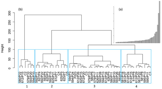
Figure 2.
Hierarchical clustering of the 48 kilns according to eight topographical and morphological variables; (a) bar plot of aggregation height; (b) dendrogram of kilns computed with Ward’s method. The blue rectangle contains the four clusters identified.
On the PCA of the kilns compared to socio-ecological/morphometry features, the first (axis 1–2) and second (axis 1–3) factorial planes represented, respectively, 59.05% and 48.01%, respectively, of the total variance. Graphical representations were thus carried out for those three dimensions, because they allow us to describe at least 80% of the information contained in each variable (except for the standard deviation of the slope).
Projections on the first two axes show the independence of kiln morphometric characteristics (area, length, width) from topographical variables (mean elevation and mean slope, Figure 3a). Geochemistry, ownership and dominant species did not vary according to either topographical or morphological variables, and a trend towards higher elevation in south and southwest kilns could be observed. Group 1, identified through hierarchical clustering (Figure 2), is linked to the presence of larger kilns (connected and dependent on the length and the width of the platforms). Group 3 represents charcoal kilns in flat areas at high elevation (=plateau areas) and Group 4, on the other side, encompasses platforms located in steep areas (i.e., higher slope inclination) and lower elevation. Finally, Group 2 encompasses the kilns with no discriminant parameters. Projections on axes 1 and 3 allow a better representation of charcoal layer thickness, but the morphological groups identified appear to be independent of charcoal layer thickness (Figure 3b).
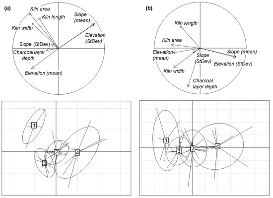
Figure 3.
(a) Correlation circle (top) and individual factorial planes of the PCA on the kiln x socio-environmental/morphometry table, for the axis 1 and 2 and the four groups obtained through hierarchical clustering (bottom). (b) Correlation circle (top) and individual factorial planes of the PCA on the kiln x socio-environmental/morphometry table, for the axis 1 and 3 and the groups obtained through hierarchical clustering (bottom). Ellipses represent 95% confidence intervals.
3.3. Taxonomic Analysis
The analysis of whole sampled charcoal fragments resulted in the taxonomic identification of 7026 fragments in a total of 12 taxa. The fragments identified as “cf.” (n = 156) and “Undetermined” (n = 150) were excluded from the analysis, reducing the total number of charcoal pieces used for the analysis to 6720 (Figure 4), as they were poorly informative. The complete results of the charcoal identification are available as supplementary material (Table S2).
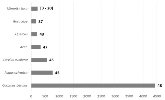
Figure 4.
Distribution of abundance among the different taxa recorded for 6720 charcoal pieces identified. Bars represent the absolute frequency (n) and the values next to each bar on the graph express the ubiquity of the taxa in the charcoal kilns (i.e., number of charcoal kilns where the taxon is present among the 48 sampled kilns).
The most frequent taxon, covering two-thirds of the overall charcoal collection, was Carpinus (66.0%), followed by Fagus (11.5%), Corylus (8.3%), Acer (5.0%), Quercus (3.2%) and Rosaceae (2.6%). The remaining taxa found were willow (Salix, 1.5%) and poplar (Populus, 0.3%) and when it was not possible to have a more precise taxonomical identification, we assigned the fragments to Salix/Populus (0.8%), Prunus (0.4%), Betula (0.2%), Cornus (0.1%), and Viburnum (0.1%).
Analysis of the charcoal taxonomic composition highlighted that Betula, being poorly represented (only present in three kilns), structured the COA too much (Figure S2). In the analysis run without this taxon, no structure could be visually identified. This was confirmed by a permutation test on the co-structure that gave, respectively, p = 0.23 and 0.19 with and without Betula. Hence, the taxa of the wood used in kilns were independent of kiln topography and morphometry.
The COA did not reveal clear relationships between species and subsample location in each sampled kiln. The structure index did not show significant differences between subsamples “a” to “e” (p-value between 0.44 and 0.71 for the five indexes, Figure S1).
3.4. Assessment of Past Woodland Management
A total of 3239 fragments were evaluated and measured (Table 2). For the dominant species, the largest mean diameter was observed in Quercus and Fagus, circa 10 cm (9.86 and 9.80 cm, respectively). A second group with Acer (6.74 cm), Rosaceae (6.19 cm) and Carpinus (5.69 cm) had intermediate diameter values. Finally, the smallest diameter of circa 4 cm was observed for Corylus (3.84 cm).
Table 2.
Diameter estimation (cm) of the most frequent taxa, with absolute frequency and percentage of class size in brackets, ordered by decreasing mean diameter (in bold) for each taxon (complete dataset on Table S3).
Along with diameters, the tree-ring curvature was also assessed. Corylus, Carpinus and Acer were the taxa with the highest percentage of strong tree ring curvature. Conversely, taxa with the higher frequency of weak tree ring curvatures were Quercus and Fagus. Finally, 25.5% (54 out of 212 fragments identified) of Quercus fragments exhibited, in the transverse section, an abrupt interruption of the latewood growth.
An investigation of the written sources yielded a total of 51,121 trees recorded in both registers, with all or part of the following information: date and place of the marking, species, age class and purpose of the marking (Table 3). Quercus represented 7.3% of the younger standards (20−25 years old), 47.2% of intermediate standards (modernes and anciens), and 100% of older standards (vieilles écorces).
Table 3.
Archive information for the period from 1783 to 1791 on tree harvesting in communal forests, timber trading in a state forest and the trees limiting the harvesting areas. The values shown are total number of trees and, in brackets, relative frequency. “Post-pioneer taxa” groups the classes representing less than 5% and include Prunus avium, Populus tremula, Sorbus torminalis, Acer spp. and Acer platanoides.
4. Discussion
4.1. Chronology of Charcoal Production
According to the radiocarbon dataset (Table 1), charcoal production in the study area is relatively recent because no dates older than modern times were retrieved. However, there is a large probability range in the ages of charcoal pieces obtained from radiocarbon dating (over c. 300 years), making it impossible to determine chronological patterns of charcoal production (i.e., phasing). This is a common problem in chronological analysis of charcoal production [19], since its main occurrence falls in a period of significant variations in atmospheric 14C (De Vries and Suess-effects, [52]), inducing a plateau in the calibration curve for the period under consideration (including modern times).
Trying to investigate more precisely the chronology of the charcoal production in our study area, we applied the OSL-dating method to some charcoal kilns, aiming to date the charcoal layer sediment. Results obtained by the OSL-dating method provided a narrower age range for the studied platforms than radiocarbon dating, pointing to the 19th to early 20th century. This appears to be very recent and is, therefore, coherent with our 14C dataset, improving it. Indeed, combining the two methods, it was possible to obtain a better supported time resolution, essential to understanding the diachrony of woodland resource exploitation. However, OSL dates only allow us to date the end of the platform use (i.e., last event of heat exposure of the sediment), and not its starting date, or phasing. Thus, even if this innovative dating combination allows us to obtain more precise chronological information, it is difficult to assess charcoal production phasing. The phasing of charcoal production is a key element, since that would provide insights about the intensity of wood harvesting through time. The density of the kilns and their morphology are not usable for this purpose either. Indeed, based on micromorphology studies, Gebhardt [17] established that platforms can be used several times for charcoal production, blurring the morphological evidence and also, probably, the chronological indicators (charcoal pieces and sediment).
Local historical written sources recorded that coppice-with-standards woodland management in the area had already started during the second half of the 18th century [11,53]. Thus, it is highly likely that charcoal production was already active in the area at this time, which is coherent with the chronological data from the kilns. Thus, combining the two dating methodologies and evidence from written historic documents, it is clear that charcoal production was in place for a long period and was still active in the region until around 100 years ago, even with the gradual introduction and increasing use of fossil fuels, especially coal.
4.2. Charcoal Kiln Morphometry
The average area of the charcoal production platforms (85.9 ± 22.4 m2) in our study area (Table 2 and Table S3) reached similar values than in regions associated with metallurgical activities [54,55,56]. Indeed, charcoal production for ore smelting was performed over larger surfaces due to the demand in fuel for this activity [57]. Our surface areas are higher than, for example, the ones observed in a Mediterranean context in central Italy by Carrari et al. [58]. In the latter case, the main purposes of the charcoal produced were linked to domestic activities, requiring smaller volumes than for industrial sites.
The average thickness of the charcoal layer (17.4 ± 5.3 cm) was lower than in neighboring regions [19,54,55,58]. In a study in Chailluz Forest (France) [55], the thickness of the charcoal layer varied between 20 cm and 30 cm. This was associated with the reuse of the charcoal kiln platforms. In our study area, there was no evidence of a stratigraphic differentiation in the charcoal layer that might point to the reuse of the same platform, even when considering the rather significant thickness of the charcoal layers (up to 32 cm). Finally, the analysis of the morphological and topographical characteristics of the kilns revealed that the thickness of the charcoal layer was not a structuring variable, since it did not allow us to differentiate the four groups identified (Figure 2). All morphological variables (length, width, area, charcoal layer depth, Figure 3 and Figure S2) were independent of their topographical position (elevation, exposure/aspect or slope). Hence, the process of charcoal kiln building does not seem to be related to either local constraints (topographic) or a strict industrial protocol (e.g., fixed size of platforms).
4.3. Taxonomic Spectrum
To assess the representativeness of the on-site sampling, a factorial correspondence analysis was conducted for the 48 sampled kilns (Figure 3). It revealed that there was no significant difference in the composition of the subsamples (n = 238) according to their location in their respective kilns. This shows that sampling in distinct positions within the charcoal kiln does not provide any additional information about the taxonomic diversity of charcoal. However, further studies are still needed to define the optimal sample size within a kiln in relation to kiln area, by, for instance, building saturation curves for species abundance and community structure index.
The taxonomic composition encompassed 12 taxa with Carpinus, comprising almost two thirds of the overall fragments identified (Figure 4). This taxon is well-known as an important resource for the production of good quality charcoal [59], having the highest wood density of all NW-European native trees (i.e., highest calorific value per kilogram). This makes charcoal produced with Carpinus one of the best suited for iron smelting. Carpinus resprouts vigorously after being cut at ground level and it was possibly favored by the coppice management regime of the woodland along with intentional selection [60].
Although Carpinus was dominant in this study, in other studies, Carpinus, when present, represented a minority or residual fraction of the composition of the charcoal samples collected [19,56,61,62,63].
Other kiln studies in lowland areas, such as in northern and central Belgium, also attested to the presence of Carpinus in the charcoal content, though with far lower percentages and never as a dominant taxon. Charcoal samples in these kilns were either dominated by Fagus [6] or Alnus [26] with a Carpinus content of 1−7% and 0.3−5.7%, respectively. Most of these kilns were much older, dating to the medieval and early post-medieval period.
In a lowland region marked by strong relief (Dordogne valley, France), the presence of Carpinus in deep valleys was significant [64], with on average 22% abundance of Carpinus, on a Quercus-dominated charcoal spectrum, and even rising to up to 70% in some charcoal collections. Another study revealed that Carpinus was actively used in charcoal production in modern times (17th–19th centuries) in the Franche-Comté region (eastern France, 55). The analysis of 11 kilns showed a co-dominance of Carpinus, Quercus and Fagus. Additionally, a recent study in a very much similar area (some tens of kilometers north of our study area) showed the presence of Carpinus as an important taxon within the charcoal content of six kilns. There, around 20% of the charcoal studied [65] was made of Carpinus. While Carpinus was more frequent than in other regions, charcoal was still dominated by Fagus and Quercus. So, it is probable that the lower presence of Carpinus in charcoal records can be related to the lack of studies at lower altitudes, where the presence of this species was, surely, common. Our study is among the first to reveal a large dominance in Carpinus use for charcoal production in lowland temperate woodlands and it was thus an important element in the composition of these forests, even accounting for selection phenomena.
4.4. Past Woodland Management
Quercus represented 23.4% of all identified trees in our historical registers, while it represented only 2% of identified charcoal pieces. This comparison cannot be extended to other species, because our historical texts do not always differentiate between Fagus and Carpinus (Table 3). Nevertheless, this allows us to state that charcoal remnants are not completely representative of the historical forest composition, in the context of coppice-with-standards management.
The presence of Carpinus in the landscape at the time of charcoal production is well documented in the written sources investigated (Table 3). The presence of Carpinus is expected for our study location and its environmental setting [59]. Dendrological information gathered from charcoal fragments (Table 1) points to a coppice-with-standards management regime, reinforcing the relevance of the historical registers we used to help our interpretation, because they also relate to coppice-with-standards forestry. Quercus and Fagus had the largest mean diameter (c. 10 cm), most likely related to the use of larger logs from aged trees. On the other hand, the mean diameters of Carpinus and Corylus were considerably smaller (c. 6 cm and 4 cm, respectively). The presence of Quercus and Fagus, albeit at low frequency, allows us to postulate that these species were also part of the woodland at that time, along with Carpinus coppices. Carpinus is well described in historical written sources as a key component of the management regime of coppice-with-standards. This management practice was related to the differential use of the species: specimens with higher value on the timber market (e.g., Quercus) were selected and sold, and the less suitable ones were used as a source of raw material for charcoal production or as firewood [53]. Thus, the long cycle of standards is connected to trees that grow slowly to large dimensions (i.e., Quercus and Fagus), and short rotation periods were used to produce a regular supply of fuelwood (i.e., Carpinus, Corylus, Alnus, etc.). The management of these areas was also performed in order to (i) regenerate wooded areas, (ii) provide a seed bank for the establishment and maintenance of woodlands, and (iii) comply with the minimum density of trees regulated by law [66].
Based on the anthracological information, it was not possible to relate the species frequencies observed from the analysis of kilns to past woodland structure and composition. To achieve a better understanding and a more reliable reconstruction of the past landscape, both natural archives and documental sources were combined. Comparing the fraction of trees before and after harvesting (Table 3), there was a marked decrease in the number of Quercus standards, Fagus and Carpinus, compared to the undifferentiated group of “Fagus and Carpinus”, comprising a heterogeneous assemblage of younger individuals not managed for timber production. Similarly, the predominant diameters and tree-ring curvature observed in the charcoal sample hints to an exploitation of small-diameter wood, likely coming, especially, from the coppiced management of Carpinus.
One important record that must be considered concerns the inventory of trees on the limits or borders of the tree felling areas. Because the selection of these trees was not dependent on the choice of the forest manager and they were not intended to be felled, this data represents a random sample of trees independent of their species or age. The records obtained showed a high percentage of Carpinus, which was not evident from the analysis of the other records.
Charcoal produced from Quercus and Fagus wood is also of good quality, but this was not the primary source of raw material in this area. Indeed, tree-ring curvature and the mean initial diameter of charcoal fragments showed that the wood used must have come from older trees in comparison with Carpinus or Corylus, for instance. Moreover, an analysis of the age pyramid of Quercus reveals that the young standards represented only a small portion (c. 8%) of the overall individuals. The opposite was verified for the standards where Quercus was the only taxon present, and the middle-aged trees represented half of the individuals. The much higher proportion of Quercus in the middle-aged standards than in the young standards shows that Quercus trees were left to grow for a long time (more than one cycle of regeneration) to provide timber. However, a remarkable amount of Quercus fragments in the studied charcoal sample presented some anatomy traits connected to low quality wood, such as sudden growth suspension in latewood. Such low-quality specimens were used for charcoal production. This particularity in tree rings can be an indication of coppice woodland management [67] or stress. Concerning Fagus and Carpinus, historical archives do not mention the occurrence of Fagus as a standard which is surprising and rare since both species must have been managed to accumulate wood, or as a way to help forest regeneration.
5. Conclusions
The study of 48 charcoal kilns from the Meuse lowlands in Northeastern France revealed the large dominance of Carpinus betulus, which is rather uncommon in charcoal kiln studies. Several chronological analyses were performed using different approaches. The results point to the post-medieval period; kilns from earlier periods were not found. This approach placed charcoal production in this area up to modern times in the 19th and early 20th century, in an era where fossil fuels were broadly used. Concerning the taxonomic diversity, along with the dominance of Carpinus, several accompanying taxa such as Fagus, Corylus or Quercus were also identified. Combining taxonomic data from both charcoal fragments and historical written sources, and the estimation of wood diameter of the charcoal remains, showed that former woodlands were most likely subject to a coppice-with-standards management regime, where small diameter wood (Carpinus or Corylus) was used for charcoal production, while large diameter wood was preferred for timber (Quercus or Fagus). Data from the charcoal archives is supported by historical written records that point to this differential use of resources. The use of Carpinus is congruent with the ecological requirements and characteristics of the tree. Carpinus is a very well-known resprouter, and is therefore a good, regular and fast wood supplier for charcoal production, unlike Quercus and Fagus that were harvested for timber. However, the role of Carpinus in long term forest dynamics in NW-European temperate lowland woodlands is still unclear, since it appears to be strongly influenced by human practices.
In the case of documental sources, the information gathered can be biased by the purpose of the information gathered. On the other hand, charcoal kiln content can be affected by bottleneck events (e.g., selection of wood for charcoal production or sampling). This study shows that the integration of different proxies in palaeo-environmental approaches is key to achieving a better understanding of resource exploitation and landscapes from the past.
Supplementary Materials
The following supporting information can be downloaded at: https://www.mdpi.com/article/10.3390/land11040555/s1. Table S1: Morphometric and socio-ecological results of sampled charcoal kilns (n = 48) in the study area. Table S2: Complete results of charcoal taxonomic identification by charcoal kiln. Table S3: Complete results of the diameter estimates (in absolute frequency), in decreasing order. Figure S1: Boxplot for the five community structure index according to the subsample location. Figure S2: Factorial planes of the COA on the kiln x vegetation table.
Author Contributions
Conceptualization, C.O., S.D. and V.R.; Formal analysis, C.O. and S.D.; Methodology, C.O., J.B., X.R., N.K.-M., D.V., J.D.G., S.D. and V.R.; Supervision, S.D. and V.R.; Writing—original draft, C.O., X.R., N.K.-M., D.V., J.D.G., K.D., S.D. and V.R.; Writing—review and editing, C.O., X.R., N.K.-M., D.V., J.D.G., K.D., S.D. and V.R. All authors have read and agreed to the published version of the manuscript.
Funding
This work was supported partly by the French PIA project “Lorraine Université d’Excellence”, reference ANR-15-IDEX-04-LUE. The exploratory luminescence research was partially funded by the UGent Special Research Fund in the frame of the Interdisciplinary Research Project “Fueling the Furnace. An interdisciplinary study of forest soils as geoarchaeological archives” (BOF-IOP project number 01IO3318).
Data Availability Statement
Not applicable.
Acknowledgments
The authors are thankful to Philippe Wagner for his contribution during fieldwork, to Jean-Pascal Franco from the Office National des Forêts, and to the team of the Observatoire Pérenne de L’Environnement.
Conflicts of Interest
The authors declare no conflict of interest.
References
- Pain, S. Power through the ages. Nature 2017, 551, S134–S137. [Google Scholar] [CrossRef] [PubMed] [Green Version]
- Tolksdorf, J.F.; Kaiser, K.; Petr, L.; Herbig, C.; Kočár, P.; Heinrich, S.; Wilke, F.D.; Theuerkauf, M.; Fülling, A.; Schubert, M. Past human impact in a mountain forest: Geoarchaeology of a medieval glass production and charcoal hearth site in the Erzgebirge, Germany. Reg. Environ. Chang. 2020, 20, 71. [Google Scholar] [CrossRef]
- Smil, V. World history and energy. Encycl. Energy 2004, 6, 549–561. [Google Scholar]
- Deforce, K.; Groenewoudt, B.; Haneca, K. 2500 years of charcoal production in the Low Countries: The chronology and typology of charcoal kilns and their relation with early iron production. Quat. Int. 2021, 593, 295–305. [Google Scholar] [CrossRef]
- Drailly, C.; Deforce, K. Two late iron age charcoal kilns from the Arlon forest (Arlon, province of Luxemburg, Belgium). LUNULA 2019, 27, 129–132. [Google Scholar]
- Deforce, K.; Vanmontfort, B.; Vandekerkhove, K. Early and High Medieval (c. 650 AD–1250 AD) Charcoal Production and Its Impact on Woodland Composition in the Northwest-European Lowland: A Study of Charcoal Pit Kilns from Sterrebeek (Central Belgium). Environ. Archaeol. 2021, 26, 168–178. [Google Scholar] [CrossRef]
- Battesti, V. Une Charbonnière Expérimentale, Méthodologie de l’anthracologie sur Charbonnière Pour Une Approche de la Gestion du Milieu Forestier en Languedoc. Master’s Thesis, Mémoire de Maîtrise, Biologie des Organismes et des Popul USTL, Montpellier, France, 1992; 44p. [Google Scholar]
- Schenkel, Y.; Bertaux, P.; Vanwijnbserghe, S.; Carre, J. An evaluation of the mound kiln carbonization technique. Biomass Bioenergy 1998, 14, 505–516. [Google Scholar] [CrossRef]
- Paradis-Grenouillet, S. Etudier les forêts métallurgiques: Analyses dendro-anthracologiques et approches géohistoriques. L’exemple des forêts du mont Lozère et du Périgord-Limousin. Ph.D. Thesis, Université de Limoges, Limoges, France, 2012. [Google Scholar]
- Gebhardt, A. Impact of charcoal production activities on soil profiles: The micromorphological point of view. ArcheoSciences 2007, 31, 127–136. [Google Scholar] [CrossRef] [Green Version]
- Hirsch, F.; Raab, T.; Ouimet, W.; Dethier, D.; Schneider, A.; Raab, A. Soils on historic charcoal hearths: Terminology and chemical properties. Soil. Sci. Soc. Am. J. 2017, 81, 1427–1435. [Google Scholar] [CrossRef] [Green Version]
- Oliveira, C.; Aravecchia, S.; Pradalier, C.; Robin, V.; Devin, S. The use of remote sensing tools for accurate charcoal kilns’ inventory and distribution analysis: Comparative assessment and prospective. Int. J. Appl. Earth Obs. Geoinf. 2021, 105, 102641. [Google Scholar] [CrossRef]
- Raab, A.; Takla, M.; Raab, T.; Nicolay, A.; Schneider, A.; Rösler, H.; Heußner, K.U.; Bönisch, E. Pre-industrial charcoal production in Lower Lusatia (Brandenburg, Germany): Detection and evaluation of a large charcoal-burning field by combining archaeological studies, GIS-based analyses of shaded-relief maps and dendrochronological age determination. Quat. Int. 2015, 367, 111–122. [Google Scholar] [CrossRef]
- Schneider, A.; Bonhage, A.; Raab, A.; Hirsch, F.; Raab, T. Large-scale mapping of anthropogenic relief features—legacies of past forest use in two historical charcoal production areas in Germany. Geoarchaeology 2020, 35, 545–561. [Google Scholar] [CrossRef]
- Trier, Ø.D.; Reksten, J.H.; Løseth, K. Automated mapping of cultural heritage in Norway from airborne lidar data using faster R-CNN. Int. J. Appl. Earth Obs. Geoinf. 2021, 95, 102241. [Google Scholar] [CrossRef]
- Davasse, B. Forêts, charbonniers et paysans dans les Pyrénées de l’est (du moyen âge à nos jours). In Pour Une Approche Géographique de L’histoire de L’environnement; GEODE (Université de Toulouse Le Mirail): Toulouse, France, 2000. [Google Scholar]
- Johnson, K.M.; Ouimet, W.B.; Dow, S.; Haverfield, C. Estimating Historically Cleared and Forested Land in Massachusetts, USA, Using Airborne LiDAR and Archival Records. Remote Sens. 2021, 13, 4318. [Google Scholar] [CrossRef]
- Bonhôte, J.; Davasse, B.; Dubois, C.; Isard, V.; Métailié, J.-P. Charcoal kilns and environmental history in the eastern Pyrenees (France). A methodological approach. In Proceedings of the Second International Meeting of Anthracology, Paris, France, September 2000; pp. 219–228. Available online: https://halshs.archives-ouvertes.fr/halshs-00808803/file/BonhA_te_et_al-Charcoal_kilns_and_environmental_history_in_Pyrenees.pdf (accessed on 9 March 2022).
- Gocel-Chalté, D.; Guerold, F.; Knapp, H.; Robin, V. Anthracological analyses of charcoal production sites at a high spatial resolution: The role of topography in the historical distribution of tree taxa in the northern Vosges mountains, France. Veg. Hist. Archaeobot. 2020, 29, 641–655. [Google Scholar] [CrossRef]
- Haneca, K.; Beeckman, H. Growth trends reveal the forest structure during Roman and Medieval times in Western Europe: A comparison between archaeological and actual oak ring series (Quercus robur and Quercus petraea). Ann. For. Sci. 2005, 62, 797–805. [Google Scholar] [CrossRef] [Green Version]
- Müllerová, J.; Pejcha, V.; Altman, J.; Plener, T.; Dörner, P.; Doležal, J. Detecting coppice legacies from tree growth. PLoS ONE 2016, 11, e0147205. [Google Scholar] [CrossRef] [Green Version]
- Vandekerkhove, K.; Baeté, H.; Van Der Aa, B.; De Keersmaeker, L.; Thomaes, A.; Leyman, A.; Verheyen, K. 500 years of coppice-with-standards management in Meerdaal Forest (Central Belgium). iForest 2016, 9, 509. [Google Scholar] [CrossRef] [Green Version]
- Szabó, P.; Hédl, R.; Šipoš, J. Standard trees versus underwood: Historical patterns of tree taxon occurrence in coppice forests. J. Veg. Sci. 2021, 32, e12963. [Google Scholar] [CrossRef]
- Müllerová, J.; Szabó, P.; Hédl, R. The rise and fall of traditional forest management in southern Moravia: A history of the past 700 years. For. Ecol. Manag. 2014, 331, 104–115. [Google Scholar] [CrossRef] [Green Version]
- Rackham, O. Ancient woodlands: Modern threats. New Phytol. 2008, 180, 571–586. [Google Scholar] [CrossRef] [PubMed]
- Deforce, K.; Boeren, I.; Adriaenssens, S.; Bastiaens, J.; De Keersmaeker, L.; Haneca, K.; Tys, D.; Vandekerkhove, K. Selective woodland exploitation for charcoal production. A detailed analysis of charcoal kiln remains (ca. 1300–1900 AD) from Zoersel (northern Belgium). J. Archaeol. Sci. 2013, 40, 681–689. [Google Scholar] [CrossRef]
- Szabó, P. Driving forces of stability and change in woodland structure: A case-study from the Czech lowlands. For. Ecol. Manag. 2010, 259, 650–656. [Google Scholar] [CrossRef]
- McGrath, M.; Luyssaert, S.; Meyfroidt, P.; Kaplan, J.O.; Bürgi, M.; Chen, Y.; Erb, K.; Gimmi, U.; McInerney, D.; Naudts, K. Reconstructing European forest management from 1600 to 2010. Biogeosciences 2015, 12, 4291–4316. [Google Scholar] [CrossRef] [Green Version]
- Domínguez-Delmás, M.; van Daalen, S.; Alejano-Monge, R.; Wazny, T. Timber resources, transport and woodworking techniques in post-medieval Andalusia (Spain): Insights from dendroarchaeological research on historic roof structures. J. Archaeol. Sci. 2018, 95, 64–75. [Google Scholar] [CrossRef]
- Szabó, P.; Müllerová, J.; Suchánková, S.; Kotačka, M. Intensive woodland management in the Middle Ages: Spatial modelling based on archival data. J. Hist. Geogr. 2015, 48, 1–10. [Google Scholar] [CrossRef] [Green Version]
- Donsimoni, M. Carte Géologique Harmonisée Du Département de La Meuse; BRGM: Orléans, France, 2007. [Google Scholar]
- Météo France. Données Publiques. Available online: https://donneespubliques.meteofrance.fr/?fond=rubrique&id_rubrique=29 (accessed on 3 May 2021).
- IGN. Inventaire Forestier National Français. Raw Data, Annual Campaigns 2005 and Following. Available online: https://inventaire-forestier.ign.fr/dataIFN/ (accessed on 3 May 2021).
- QGIS Development Team. QGIS 3.10. 2019. Available online: https://www.qgis.org (accessed on 9 March 2022).
- Ludemann, T.; Nelle, O. Die Wälder am Schauinsland und Ihre Nutzung Durch Bergbau Und Köhlerei; Forstliche Versuchs-und Forschungsanst: Baden-Württemberg, Germany, 2002. [Google Scholar]
- Knapp, H.; Robin, V.; Kirleis, W.; Nelle, O. Woodland history in the upper Harz Mountains revealed by kiln site, soil sediment and peat charcoal analyses. Quat. Int. 2013, 289, 88–100. [Google Scholar] [CrossRef]
- Westerhuis, J.A.; Hoefsloot, H.C.; Smit, S.; Vis, D.J.; Smilde, A.K.; van Velzen, E.J.; van Duijnhoven, J.P.; van Dorsten, F.A. Assessment of PLSDA cross validation. Metabolomics 2008, 4, 81–89. [Google Scholar] [CrossRef] [Green Version]
- R Core Team. R: A Language and Environment for Statistical Computing; R Foundation for Statistical Computing: Vienna, Austria, 2020. [Google Scholar]
- RStudio Team. RStudio: Integrated Development for R; RStudio, PBC: Boston, MA, USA, 2020; Available online: http://www.rstudio.com/ (accessed on 9 March 2022).
- Dray, S.; Dufour, A.-B. The ade4 package: Implementing the duality diagram for ecologists. J. Stat. Softw. 2007, 22, 1–20. [Google Scholar] [CrossRef] [Green Version]
- Schweingruber, F.H. Anatomy of European Woods; Paul Haupt: Bern, Switzerland, 1990. [Google Scholar]
- Dufraisse, A.; Coubray, S.; Girardclos, O.; Nocus, N.; Lemoine, M.; Dupouey, J.-L.; Marguerie, D. Anthraco-typology as a key approach to past firewood exploitation and woodland management reconstructions. Dendrological reference dataset modelling with dendro-anthracological tools. Quat. Int. 2018, 463, 232–249. [Google Scholar] [CrossRef]
- Nelle, O. Woodland history of the last 500 years revealed by anthracological studies of charcoal kiln sites in the Bavarian Forest, Germany. Phytocoenologia 2003, 33, 667–682. [Google Scholar] [CrossRef]
- Paradis-Grenouillet, S.; Dufraisse, A.; Allée, P. Radius of curvature measurements and wood diameter: A comparison of different image analysis techniques. In Proceedings of the Fourth International Meeting of Anthracology, Paris, France, 4–9 September 2009; pp. 73–182. [Google Scholar]
- Ramsey, C.B. Bayesian analysis of radiocarbon dates. Radiocarbon 2009, 51, 337–360. [Google Scholar] [CrossRef] [Green Version]
- Reimer, P.J.; Austin, W.E.; Bard, E.; Bayliss, A.; Blackwell, P.G.; Ramsey, C.B.; Butzin, M.; Cheng, H.; Edwards, R.L.; Friedrich, M. The IntCal20 Northern Hemisphere radiocarbon age calibration curve (0–55 cal kBP). Radiocarbon 2020, 62, 725–757. [Google Scholar] [CrossRef]
- Karimi Moayed, N.; Vandenberghe, D.; Deforce, K.; Bastiaens, J.; Ghyselbrecht, E.; Debeer, A.-E.; De Smedt, P.; De Clercq, W.; De Grave, J. Bypassing the Suess-effect: Age determination of charcoal kiln remains using OSL dating. J. Archaeol. Sci. 2020, 120, 105176. [Google Scholar] [CrossRef]
- Murray, A.S.; Wintle, A.G. Luminescence dating of quartz using an improved single-aliquot regenerative-dose protocol. Radiat. Meas. 2000, 32, 57–73. [Google Scholar] [CrossRef]
- Murray, A.S.; Wintle, A.G. The single aliquot regenerative dose protocol: Potential for improvements in reliability. Radiat. Meas. 2003, 37, 377–381. [Google Scholar] [CrossRef]
- De Corte, F.; Vandenberghe, D.; De Wispelaere, A.; Buylaert, J.-P.; Van den Haute, P. Radon loss from encapsulated sediments in Ge gamma-ray spectrometry for the annual radiation dose determination in luminescence dating. Czech. J. Phys. 2006, 56, D183. [Google Scholar] [CrossRef]
- Rochel, X. Forest Management and Species Composition: A Historical Approach in Lorraine, France. In Europe’s Changing Woods and Forests: From Wildwood to Managed Landscapes; Kirby, K.J., Watkins, C., Eds.; CABI: Boston, MA, USA, 2015; pp. 279–288. [Google Scholar]
- Tans, P.; De Jong, A.; Mook, W. Natural atmospheric 14 C variation and the Suess effect. Nature 1979, 280, 826–828. [Google Scholar] [CrossRef]
- Buckley, G.P. Ecology and Management of Coppice Woodlands; Springer Science & Business Media: London, UK, 2012. [Google Scholar]
- Allée, P.; Paradis, S.; Boumédiène, F.; Rouaud, R. L’exploitation médiévale du plomb argentifère sur le mont Lozère. Archéologie spatiale d’un territoire proto-industriel montagnard. ArcheoSciences 2010, 34, 177–186. [Google Scholar] [CrossRef] [Green Version]
- Dupin, A.; Girardclos, O.; Fruchart, C.; Laplaige, C.; Nuninger, L.; Dufraisse, A.; Gauthier, E. Anthracology of charcoal kilns in the forest of Chailluz (France) as a tool to understand Franche-Comte forestry from the mid-15th to the early 20th century AD. Quat. Int. 2017, 458, 200–213. [Google Scholar] [CrossRef]
- Ludemann, T. Past fuel wood exploitation and natural forest vegetation in the Black Forest, the Vosges and neighbouring regions in western Central Europe. Palaeogeog. Palaeoclim. Palaeoecol. 2010, 291, 154–165. [Google Scholar] [CrossRef]
- Rösler, H.; Bönisch, E.; Schopper, F.; Raab, T.; Raab, A. Pre-industrial charcoal production in southern Brandenburg and its impact on the environment. In Landscape Archaeology Between Art and Science; Amsterdam University Press: Amsterdam, The Netherlands, 2012; pp. 167–178. [Google Scholar]
- Carrari, E.; Ampoorter, E.; Bottalico, F.; Chirici, G.; Coppi, A.; Travaglini, D.; Verheyen, K.; Selvi, F. The old charcoal kiln sites in Central Italian forest landscapes. Quat. Int. 2017, 458, 214–223. [Google Scholar] [CrossRef]
- Rameau, J.-C.; Mansion, D.; Dumé, G. Flore Forestière Française: Plaines et Collines; Forêt Privée Française: Paris, France, 1989. [Google Scholar]
- Matula, R.; Svátek, M.; Kůrová, J.; Úradníček, L.; Kadavý, J.; Kneifl, M. The sprouting ability of the main tree species in Central European coppices: Implications for coppice restoration. Eur. J. For. Res. 2012, 131, 1501–1511. [Google Scholar] [CrossRef]
- Ludemann, T. Large-scale reconstruction of ancient forest vegetation by anthracology—A contribution from the Black Forest. Phytocoenologia 2003, 33, 645–666. [Google Scholar] [CrossRef]
- Knapp, H.; Nelle, O.; Kirleis, W. Charcoal usage in medieval and modern times in the Harz Mountains Area, Central Germany: Wood selection and fast overexploitation of the woodlands. Quat. Int. 2015, 366, 51–69. [Google Scholar] [CrossRef]
- Nölken, W. Holzkohleanalytische Untersuchungen zur Waldgeschichte der Vogesen; Verlag Nicht Ermittelbar: Freiburg, Germany, 2005. [Google Scholar]
- Rouaud, R. Les forêts de pente de la haute vallée de la Dordogne: Enjeux écologiques et énergétiques d’une ancienne forêt charbonnée (Auvergne, Limousin, France); Université de Limoges: Limoges, France, 2013. [Google Scholar]
- Robin, V.; Dufraisse, A.; Oliveira, C. The analysis of relic charcoal kilns for the assessement of forest trajectories. 2021; in press. [Google Scholar]
- Keyser, R. Wood for Burning: The Continuity of Woodland Management in Medieval and Early Modern France. In Environmental History in the Making; Springer: Cham, Switzerland, 2017; pp. 307–320. [Google Scholar]
- Deforce, K.; Haneca, K. Tree-ring analysis of archaeological charcoal as a tool to identify past woodland management: The case from a 14th century site from Oudenaarde (Belgium). Quat. Int. 2015, 366, 70–80. [Google Scholar] [CrossRef]
Publisher’s Note: MDPI stays neutral with regard to jurisdictional claims in published maps and institutional affiliations. |
© 2022 by the authors. Licensee MDPI, Basel, Switzerland. This article is an open access article distributed under the terms and conditions of the Creative Commons Attribution (CC BY) license (https://creativecommons.org/licenses/by/4.0/).