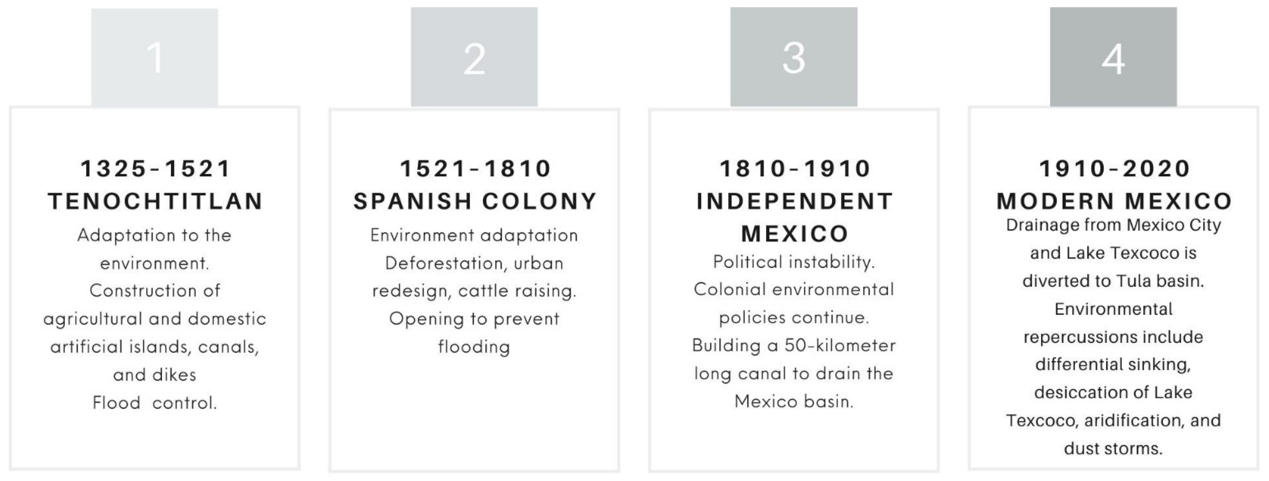
4.1. Tenochtitlan and Lake Texcoco (1325–1521)
According to historians, the modern state of Mexico began in the late postclassic period, 625 years ago, with the founding of Tenochtitlan in 1325. Tenochtitlan’s founders, the Mexica, were the last Mesoamerican people to build the city in the fourteenth century on one of the western islets of Lake Texcoco in the Valley of Mexico basin [
25].
For two centuries, the Mexica altered the lake system, resulting in the development of intricate hydraulic infrastructure systems. The works served a variety of purposes and were constructed on both land and in riparian and lake environments. Palerm [
24] identified and defined the most significant hydrotechnical works including
Chinampas (described by the author as an “inside lagoon”, an artificial island built by the Mexica for agriculture and settlement), causeways,
albarradones (colonial and pre-Hispanic hydraulic works that functioned as dikes), flood defense and drainage works, freshwater conduction through canals, ditches and aqueducts, and formation of lagoons and artificial swamps.
At the middle of the island was the ceremonial center. The population settled around it on chinampas where they built their houses and developed agriculture, all this without damaging its natural lacustrine condition. The causeways that linked the island to the mainland in turn divided the lake. They also built aqueducts to supply drinking water to the island from the springs of Chapultepec and Coyoacán, navigable canals for the transport of people or goods and ditches for the distribution of drinking water and irrigation.
Tenochtitlan did not escape flooding. The community that evolved within that lake ecosystem figured out how to manage the lakes’ water levels in order to limit damage. According to historical sources, two main constructions had their origin in environmental events, the Nezahualcóyotl and the Ahuízotl
albarradón [
31].
As a result of the 1449 flood, Nezahualcóyotl (tlatoani or emperor of Texcoco from 1402 to 1472) built a 16-km-long albarradón that connected the Tepeyac hill to the Santa Catalina Mountain range in order to prevent flooding caused by Lake Texcoco’s overflow. This also allowed for the segregation of the Mexico Lagoon’s fresh waters from the saline waters of Lake Texcoco.
On the other hand, the flood of 1499 was triggered by Ahuízotl (Tlatoani of Tenochtitlan from 1486 to 1502) when he attempted to build an aqueduct connecting Coyoacán and the city. The city was flooded for 40 days following the inauguration of the aqueduct and, in response to this catastrophe, they built another albarradón.
The Mexica developed a great empire in Mesoamerica through hydrotechnical works; by the 16th century, the city of Tenochtitlan had a population of between 170 thousand and 200 thousand inhabitants, and the entire basin had a population of about 1 million [
2]. The prosperity of the cities inside the basin demonstrates that they used water as a tool to achieve a successful empire.
4.2. The Spanish Colony and the Drain to Prevent Flooding (1521–1810)
During the period of the Spanish conquest, there was a significant change in the landscape of Lake Texcoco. It is at this point in history that there is a transformation in the way people relate to the lake environment.
The Spanish explorers and conquistadors led by Hernán Cortés entered Tenochtitlan on 8 November 1519. After almost two years of invasion, the final strategy of the Spaniards was to cut off the supply of drinking water and the entry of food. The Mexica were defeated by using the same natural resource that they had used to establish their empire.
What occurred following the conquest would be significant for the future of Lake Texcoco. The capital of New Spain had to be built, and among the possible locations were Coyoacán, Tacuba, Texcoco, and Tenochtitlan. Hernán Cortés is credited with the idea to establish Mexico City on the ruins of Tenochtitlan, citing political measures to ensure the Spanish conquest was effective and definitive. In this regard, José María Marroquí in his book
La Ciudad de México published in 1900 [
32], mentions that Cortés considered it dangerous to leave the old city free given the possibility that over time the indigenous people could try to recover their temples, palaces and monuments.
Between the demolition of the Mexica city and the creation of the Spanish one, forty years passed. New emblematic buildings were built over the old ones such as the Cathedral of Mexico over Templo Mayor ruins. The pre-Hispanic period moved gradually towards the consolidation of Spanish rule and the beginning of the colonial period. Historians date the end of the conquest stage to around 1560, when tribute began to be expressed in pesos and paid in currency [
33].
The new layout of the city broke the natural balance with the lake environment that the Mexica maintained. Furthermore, forests were cut down to use wood for new buildings, to make furniture or as fuel. Furthermore, some rivers were diverted, dried up or polluted. All this altered the physiognomy and productivity of the basin, starting the process of change in the hydrological system [
34].
As geographer and naturalist Alexander von Humboldt pointed out in his 1827 publication Political Essay on New Spain [
18], “the first conquerors wanted the beautiful valley of Tenochtitlan to resemble in everything the Castilian soil, in the arid and devoid of its vegetation” (translation from Spanish). His observation tells us that, unlike the Mexica civilization, the Spaniards were unfamiliar with floodplains as inhabited spaces, and therefore the conquest altered the interaction between humanity and the basin’s natural lake environment.
The changes they made to the pre-Hispanic hydraulic system caused major floods, prompting a series of decisions to mitigate them, including attempts to replicate some of the works built by indigenous people in the past, but without achieving the same results due to the change already present in the environment.
An example of this is the
albarradón of Nezahualcóyotl, which was demolished to allow the entry of Spanish vessels, causing a great flood in 1555. The Viceroy of New Spain, Luis de Velasco y Ruz de Alarcón, ordered the construction of a dike between the Calzada de Guadalupe to the north and the Calzada de Iztapalapa to the south of the city to substitute for the Netzahualcóyotl
albarradón. This construction would be known as the
albarradón de San Lázaro [
19].
However, the albarradón of San Lázaro was not enough to stop the floods. In 1580, another great flood occurred. At that time, Viceroy Martin Enrique de Almanza was overseeing New Spain, and the idea of draining the lagoon surrounding Mexico City started to be mentioned as a solution to flooding.
Another flood occurred in 1604 and another shortly after, in 1607. Viceroy Luis de Velasco y Castilla ordered the construction of a tunnel that would pass through the northeast corner of the basin with the purpose of draining Lake Zumpango and preventing further flooding. The design would divert the waters of the Cuautitlán River to the Tula River. The person in charge of the design and construction of the Huehuetoca tunnel was the engineer and cosmographer Enrico Martínez [
35]. The Valley of Mexico basin ceased to be an endorheic basin as a result of the development of this project.
Perló Cohen and González Reynoso [
36] point out that the Huehuetoca tunnel prevented Mexico City from flooding as a consequence of the north’s growing rivers and lakes. However, the east, south, and central valley overflows into Lake Texcoco were not controlled, and flooding occurred again in 1615 and 1623.
The flood of 1623 occurred during the government of Viceroy Diego Carrillo de Mendoza y Pimentel, who, according to Lattes [
19], had opted to allow the lagoons to once again receive the flow of the rivers due to the high cost of maintaining the works. The entrance of the artificial drainage was blocked so that the waters of Zumpango could reach Lake Texcoco; the result was a gradual increase in water levels in the city and, by 1627, many of the streets were again flooded.
Numerous repairs were required both within the city and on the dikes and canals. The Huehuetoca tunnel was modified to become an open pit, allowing the necessary effluent to flow, but the Nochistongo gorge would not be completed until 1789 [
35].
However, the most devastating flooding of the time had not yet occurred. In 1629, a deluge known as the San Mateo Deluge struck Mexico City. It rained continuously for 40 h. For five years, the city was submerged in water due to the flood. Water levels in the city center were recorded as high as two meters, and it would take until 1634 for a drought to put an end to such an overwhelming flood. The cost of the destruction was enormous. At the time, the population was believed to be 150,000, of which about 30,000 died as a result of the flood and its effects, such as the city’s insalubrity. Another significant portion of the population emigrated to various cities throughout the country.
Throughout the 18th century, the government of New Spain continued to work on the drainage of the Valley of Mexico basin. Among them were the albarradón de San Mateo canal in 1747, the Guadalupe canal in 1796, and the Zumpango canal in 1798 to connect them to the Nochistongo gorge; despite the large lake area drained as a result of these works, the city continued to flood.
Valek Valdés [
35] recounts the observations of the renowned geographer and naturalist Alexander von Humboldt on the works that supported the security of the capital at the beginning of the 19th century; among them were the stone causeways that prevented the waters of Zumpango from reaching the Lake San Cristóbal and ending in Lake Texcoco, the causeways and locks of Tláhuac and Mexicaltzingo, in the Nochistongo gorge that took the waters from Cuautitlán River to Tula River and, finally, the two Mier canals that allowed lakes Zumpango and San Cristóbal to drain.
As of now, the administration of natural resources was influenced by the omission of efforts that the country’s native inhabitants had made for generations, shifting the concept of a civilization to adapt to the environment to now adapting the environment to the goals of the new civilization. According to Mann [
26] in his analysis of the arrival of Spanish in the Americas, the assumption was that the new continent was pristine, and natural adaption mechanisms ignored.
4.3. The Drainage Proceeds during the Independent Period (1810–1910)
The country’s political instability at the turn of the nineteenth century was evident in the condition of decay of the drainage works. During this time period, the government transitioned from a monarchy to a centralist republic to a federalist republic; hence, the drain was abandoned amid armed revolutions and power struggles. According to the engineer Francisco de Garay [
3], it was forgotten at those times that personnel guarded the Nochistongo gorge in the north.
Dr. José María Mora, one of Mexico’s most illustrious liberalism figures, was commissioned in 1823 to conduct a diagnosis on the state of the drainage work, in which he describes the state of complete abandonment and the pressing need for repairs. Mexico City was in danger of flooding due to the unevenness in relation to the lake caused by the constant deposit of earth carried by the rivers that flowed into the lake. Additionally, he expresses his opinion on the mishandling of past works, which were pricey and brief in duration [
37].
In 1847, as the North American army marched towards the Valley of Mexico and Antonio López de Santa Anta was president of the Republic, the eastern sector was flooded as a defensive measure, digging the Viga canal and breaching the Mexicaltzingo locks. This move failed as a military tactic and instead served to exacerbate the risk of flooding in the capital and southern villages. Following that, engineers Francisco de Garay and M.L. Smith repaired the structure.
On 22 April 1853, the Ministry of Development was established, having authority over the canals and drainage of the Valley of Mexico. The proposal to use the city’s hydraulic system for navigation was made as early as 1830 by Lucas Alamán, the country’s Minister of Interior and Foreign Affairs Relations at the time, and was implemented briefly, but the shallowness of the canals and dikes, as well as the maintenance costs associated with them, increased interest in drainage. [
4].
It was not until 1856 that the waters of Lake Texcoco threatened the city again, and in accordance with the established plan of action, a thirty-member General Board was appointed, which would later appoint a Minor Board to oversee the necessary repairs to the city’s aging hydrotechnical works, with engineer Manuel Gargollo assigned to the north section, Juan Manuel de Bustillo to the center, and Francisco Garay to the south.
To the north, the Tepotzotlán and San Ignacio outlets were restored to the west bank of the Cuautitlán River, canals were cleaned to restore water to Lake Zumpango, and the Guadalupe canal was reopened. The San Cristóbal dike was reinforced in the center, and it was proposed that the Teotihuacan dike be restored in order to unload the Texcoco reservoir. It was, nevertheless, completely planted and occupied. The landowners presented the solution to facilitate the deposit of the waters by erecting many dams. All of these efforts were insufficient due to their unplanned nature, but in the south, the engineer Garay’s efforts were part of a scheme presented years previously that was more successful.
In the south, the diversion in the Mexicaltzingo dike was closed, and the breaches in the Culhuacán and Tláhuac causeways were fixed, while the walls’ height was increased to compensate for being totally submerged by the lakes’ water. Additionally, the San Lorenzo canal was constructed to cut through the dividing hill between Xochimilco and Texcoco, and a floodgate was constructed in Mexicaltzingo to simply and rapidly manage water flow. Over the next five months, the Chalco and Xochimilco lakes increased their water levels by 56 cm, while the Texcoco lake decreased.
“The lake of Texcoco being the lowest in the entire valley and with no outlet for its waters, all the salts that the landslides of the mountains pull on their route are deposited there,” said Francisco de Garay [
3]. Additionally, the salting in lakes was becoming more evident because in the dry season, during the ebb of its waters, salts sprout from the ground, rising to the surface by the capillarity effect or evaporation. The sun evaporates the water, leaving the salt behind, causing the deposit to grow (ibid).
De Garay also mentions that in the time prior to the Spanish conquest, it was common to find a large quantity of fish in Lake Texcoco, but that it had disappeared for at least a century. While the albarradón de Nezahualcóyotl was standing, the rivers of the west flowed around the capital, and through the San Lázaro floodgate, there was a freshwater stream at the foot of Peñón Chico, which turned it into a beautiful orchard. With less water coming from the south and no water coming from the north, an important area lost its ability to grow food. Instead, tequezquite, a mineral salt, or ground salt, was harvested.
During his exploratory trips to the American continent in 1803–1804, Alexander von Humboldt [
18] describes the distance from the center of Mexico City to Lake Texcoco as 4500 m, and more than 9000 m to Lake Chalco, and notes a depth of 3 to 5 m in some areas, and up to a meter in others.
Thus, during the first two-thirds of the nineteenth century, the valley’s drainage and the drying out of Lake Texcoco were effectively halted, but once a degree of stability was achieved toward the end of the century, the drainage was once again promoted primarily by political actors and social elites, despite warnings about the potential environmental consequences that were already looming. As Miranda Pacheco [
38] points out, even though drainage works were restarted in the 1870s, the city’s long-term growth was due to the “interests and projects” that had been built on private property and public land since the beginning of the century, even before the country became independent (59 p.).
On the other hand, Vitz [
23] notes that the environmental practices that dominated the twentieth century were patrimonial and commercial exploitation of natural resources, which benefited from political instability and a colonialist-influenced society. This occurred in a political climate in which decisions affecting the natural environment were made on the basis of what was urgent and convenient. He also emphasized the differences in how different socioeconomic classes relate to the environment.
4.3.1. The Decision That Perpetuated the Desiccation of Lake Texcoco in the Second Mexican Empire
For the first time during the Second Mexican Empire, drainage of the entire valley was considered to combat flooding in the city. Despite Maximilian of Habsburg’s liberal thinking and appreciation for Mexican nature, the draining decision was influenced by the conservative group that participated in the monarchy’s formation. Miranda Pacheco [
38] highlights the participation of politicians, doctors, lawyers, engineers, geographers and the upper class of society.
Shortly after Maximilian of Habsburg’s arrival in 1864, the city faced another flood, and to find a solution, national and international experts were invited. The board of experts chose engineer Francisco de Garay’s proposal, which included a network of staggered canals for drainage, navigation, and irrigation, with north and south extensions. The objective was to be able to control the level of nearly all vessels by creating additional reservoirs and eradicating stagnant waters. It was a very ambitious project that required a significant expenditure, which is why it was harmed by budgetary constraints following the restoration of the Republic in 1867.
Maximilian chose as his first option the drainage plan proposed by engineer M.L. Smith in 1848, who recommended not drying the lakes but connecting them via a canal, where it would be possible to balance the lakes’ waters by utilizing the difference in their heights, thereby avoiding overflow into the city. Others proposed the construction of artificial containers to repurpose excess water in agriculture. The order of 27 April 1866 reflected this decision; nevertheless, on 13 November the same year, the decree was published to carry out Francisco de Garay’s plan, originally offered in 1856 and selected as the winner of the Minor Drainage Board’s call for proposals.
This change of decision on the part of Maximilian was partly influenced by his advisers, who convinced him of the obstacles that the waters would present, overflowing or not, to his urban projects, as well as for those people close to him [
38]. A letter written on 3 July 1866, by the First Engineer, Miguel Iglesias of the Ministry of Development, explains a different situation to Maximilian:
“Indeed, for our lovely capital, it is a benefit of such transcendence (the drain) that it may be stated that its life is in it, because without it, we will always have it nearly flooded and in risk of becoming completely flooded, and thus seeing it in ruins. It is also an issue for the other populations that dwell in its shadow: how much would their inhabitants lose if that center of business and consumption provided all of their needs? Additionally, even if it were not to protect them from the calamity of a flood, the welfare and health of the valley’s inhabitants; the increase in fertility and production that will result from the cultivation of the vast lands currently occupied by the waters of one of the lakes that are so harmful due to the poor conditions in which they are found; the new and convenient communication routes created by the numerous canals that will cross the valley; all of these are enormous benefits” [
4]
(translation from Spanish)
Notably, M.L. Smith had previously emphasized the dry fields of the San Lázaro canal, an ancient link between Texcoco and Mexico City. He designated them as sterile plains due to their location within a salty lake basin. The flood of 1865 compelled them to act immediately, and as a result, a series of steps for the drainage works were undertaken. Francisco de Garay was appointed “sole and responsible director and inspector of all activities relating to the water issue in the Valley of Mexico” during this conflict. Francisco de Garay, on the other hand, was a devout Republican liberal who accepted the designation without title or compensation.
The lake’s water had already reached the streets of Mexico City by October 1865. The situation was critical, and the city’s engineers were called in to help. Francisco de Garay [
3] indicated that the flood exceeded twice the usual surface of the lakes, invading the entire eastern part of the city, and that “to save the capital from danger, it was necessary to lower the level of Lake Texcoco”. The urgent drainage plan presented by Francisco de Garay obtained most of the votes and was defended against Maximilian when he questioned its effectiveness. De Garay was so sure that he bet his own head [
3].
The proposal called for isolating Lake Texcoco so that the northern and southern lakes would not continue to discharge their surpluses into the basin’s lower reaches. Dikes were built, and help was once again sought from ranches, farms, and adjoining areas in order to construct artificial basins and reduce the risk of flooding in the city’s towns and neighborhoods. The water level in Mexico City’s historic center was 54 cm lower than in 1629. When the waters receded in 1866, the floors of the flooded streets and squares were ordered to be raised.
In May 1866, Emperor Maximiliano established the Drainage Commission, which included engineers Miguel Iglesias, Aurelio Almazán, Manuel Álvarez, and Jess Manzano, to conduct field studies and verify that the drainage project proposed by Smith was feasible, which they endorsed; work began at the end of the year. He also arranged for Miguel Iglesias to travel to Europe to purchase the necessary machinery [
4].
The works conducted during this time period are detailed in the 1868 Development Memory and in the compilation of reports from the Historical, Technical and Administrative Memory of the Valley of Mexico Drainage 1449–1900; nevertheless, the lack of resources meant that most of the works of the drainage were postponed, and government engineers were then mainly concerned with conducting field studies and conservation works.
Maximilian of Habsburg was a European liberal who, upon his arrival, developed a policy in disagreement with the traditional position of the conservative class and the Mexican clergy but, due to his short duration in government, his influence did not reach the entire national territory.
Mexico City’s architectural design, which began at this time, would last for decades, and projects for lake drainage would also continue. Vitz [
23] points out that during this time, the priority was to safeguard the city from floods and protect private property, even when the interdependence of these with their environment was recognized.
4.3.2. The Porfiriato (1876–1911) and the Basin’s Second Opening
The hydraulic work that offers a second outlet to the basin is known as the Grand Drainage Canal. This work was part of several urbanization initiatives in Mexico City under the presidency of Porfirio Díaz, with the distinction that it was begun during Maximilian’s reign. During the Porfiriato, Mexico experienced rapid development, which was made possible by foreign investment. The infrastructure of the railway, telegraph, telephone, and electricity were expanded. Despite the city’s economic expansion and modernization, it was a time marked by economic disparities among the inhabitants.
The drainage works were cut off from the Ministry of Development in 1867 by the Ejército de Oriente in Mexico City. It was left behind because it was considered as an imperial endeavor. Andres Almazán, José Iglesias, and Jose Manzano came to Porfirio Díaz to ask for help. Porfirio Díaz’s reaction, in his letter of 11 May 1867, is as follows [
4]:
“Having read with pleasure VV’s report on the work being done in Zumpango to aid Valley Drainage [..], I could wish for a few glories in my temporary position, such as adding momentum to these operations [...] As a result, [...] I have directed that the Federal District Treasury Department minister to them the sum of 1500 pesos each month for the conservation of drainage works, while the Supreme Government determines that they continue and carry out with appropriate diligence”
(translation from Spanish)
Blas Balcárcel was heading of the Ministry of Development when the Republic was restored in 1867. Together with the Minister of Finance, José Mara Iglesias, he was successful in obtaining approval for a special tax to fund the drainage works. This tax included a 50% rise in municipal taxes collected at customs in the capital, as well as a 20% increase in direct taxes collected in the Valley of Mexico.
The drainage works were restarted in April 1868, but a later decree prohibited the special funds, and these entered a common fund. As a result, the works received an allocation from the general budget. The instability in the public peace influenced the perception of the amount destined for the works, which caused them to be paralyzed in October 1871. The completion of the outlet was the focus of the work done between 1868 and 1871.
The valley’s drainage was also viewed as a solution to the city’s health and hygiene issues. The Mexican Society of Geography and Statistics issued an opinion on the valley’s drainage in 1874, arguing that doing so would prevent the physical and moral degeneration of their race and that the desiccated lands could be sold to benefit commerce, agriculture, hygiene, and the public treasury [
38].
Miranda Pacheco [
38] reveals the many perspectives on the valley’s draining at the time. The Hygiene Commission of the Academy of Medicine in Mexico (at first), Doctor Eduardo Liceaga (president of the Medical Congress, family doctor, and close friend of Porfirio Daz), and Francisco de Garay were among those who supported it.
Those who opposed the drainage included Manuel Orozco y Berra, who believed that the city’s drainage should be separated from the valley’s drainage so that the Texcoco lake did not become a gigantic sewer. To stop the putrid emanations towards the city and limit the surface of the basin, Leopoldo Río de la Loza recommended reforestation of the area near Lake Texcoco. The doctor José G. Lobato noted, in his 1877 study, Hygienic Study on the Exanthematous Typhus, that preserving the surface of the lakes would reduce outbreaks of typhoid infections, a phenomenon that in pre-Hispanic times did not occur, but the Matlazahuatl pandemic happened when the lake’s surface had dropped with the Spanish [
38].
Rivalries between drainage officials, particularly between engineers Francisco de Garay and Luis Espinosa, were not new to the project. The tunnel’s placement and hydraulic flow were two of the most contentious issues. Initially, the tunnel was designed to follow M.L. Smith’s plan via the Acatlán ravine, and construction began in that direction. Francisco de Garay, on the other hand, thought it should go through the Ametlac ravine. When Manuel Fernández de Leal took over the Ministry of Development and designated him acting director of Works, Luis Espinosa’s decision was eventually imposed.
As a result, until 1879, it was unclear how much water had to be extracted. The engineers predicted sizes and slopes for unusual and severe rain, which raised the cost of the project. Previously, M.L. Smith estimated a flow of 8 cubic meters per second, Francisco de Garay calculated a flow of 33 cubic meters per second, and Miguel Iglesias (head of the commission that studied and laid out the drain in 1866) calculated a flow of 41 cubic meters per second [
4].
Porfirio Díaz accepted the drainage scheme for the Valley of Mexico presented by Luis Espinosa in 1879. It was based on the previous one by Francisco de Garay and took into account the work already completed by Miguel Iglesias but rectified the tunnel’s hydraulic flow by 21 cubic meters per second. From 1871 to 1886, Luis Espinosa served as director of drainage works in the Valley of Mexico and as director of the Drainage Board of Directors.
According to Luis Espinosa [
39], the lake of Texcoco was destined to disappear since the waters that came from the springs, wells, and drainage of the city were not enough to maintain the extension of the lake. Furthermore, he mentions the health issue commenting that “there are respectable opinions that foresee a danger to health in the complete drying up of the lakes”.
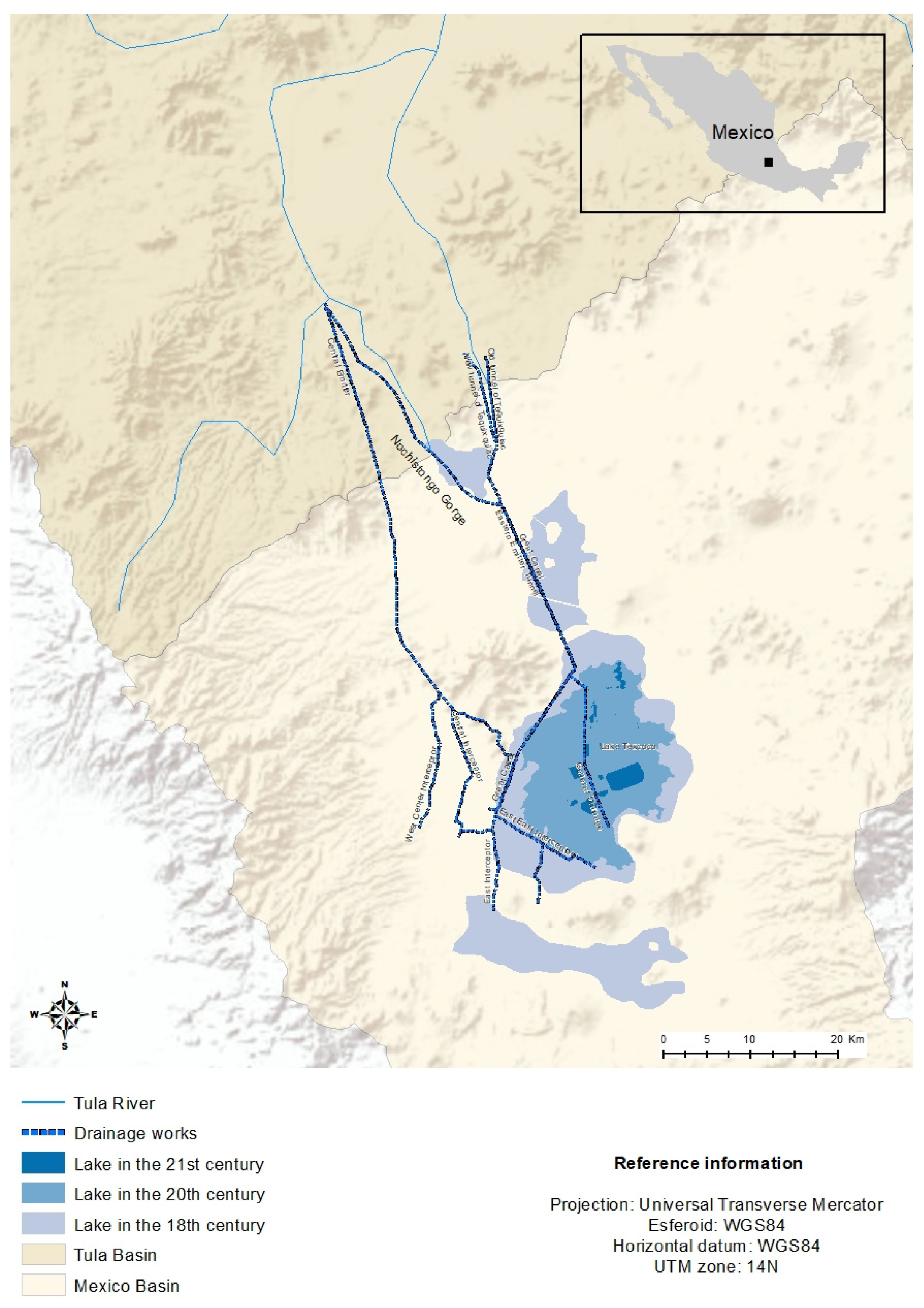
With the return of Porfirio Díaz to power in 1884, the project gained enough momentum to be completed. The entire project consisted of three major parts: an open gorge 39.5 km long from Lake Texcoco to the northeast end of Lake Zumpango, a tunnel almost 10 km long from the shore of Lake Zumpango traveling northwest up to the Acatlán ravine, also known as Tequixquiac, and a canal. This would carry water from the Tequixquiac River, which meets the Tula River and, downstream, creates the Moctezuma River, to Pánuco, and finally empty into the Gulf of Mexico [
4].
During the Porfirio Díaz administration, a budget close to 16 million pesos was allotted for the construction of the Grand Drainage Canal between 1886 and 1900. It was dedicated on March 17, 1900, in the presence of the President of the Republic, some Secretaries of State, various members of the diplomatic corps, the Drainage Canal Board of Directors, engineers, employees, and visitors from banking, commerce, industry, and the arts. In this regard, Luis Gonzales Obregón, a member of the Drainage Canal’s Board of Directors, wrote:
“March 17, 1900, will be a memorable date, because the works inaugurated on this day together with those of sanitation, will make Mexico one of the most pleasant mausions, among the capitals of the American Republics, for its beauty, health and climate”
(translation from Spanish)
Mexico City was already far removed from its lacustrine origins at the time of the Grand Drainage Canal’s opening. The Hydrographic Commission of the Valley of Mexico estimated that the lakes’ maximum extension during the rainy season would be 536.50 square kilometers, with the surface area of Lake Texcoco ranging between 183.28 and 238.54 square kilometers, depending on the amount of water received and the amount of precipitation expected throughout the year (
Table 1).
In the act issued on the inauguration of the drainage works in the Valley of Mexico, the Grand Drainage Canal is described as a great and beneficial work that will liberate Mexico from floods and improve the hygienic conditions of the capital and the valley [
4]. The work was seen as an engineering feat and a symbol of the progress and modernity of the country.
However, only four months later, a second flood revealed that the work was ineffective. The Grand Canal’s status would deteriorate over time, as the canal’s movement was determined by gravity and Mexico City was sinking. The Grand Drainage Canal displaced about one million cubic meters of water in its first four years [
40].
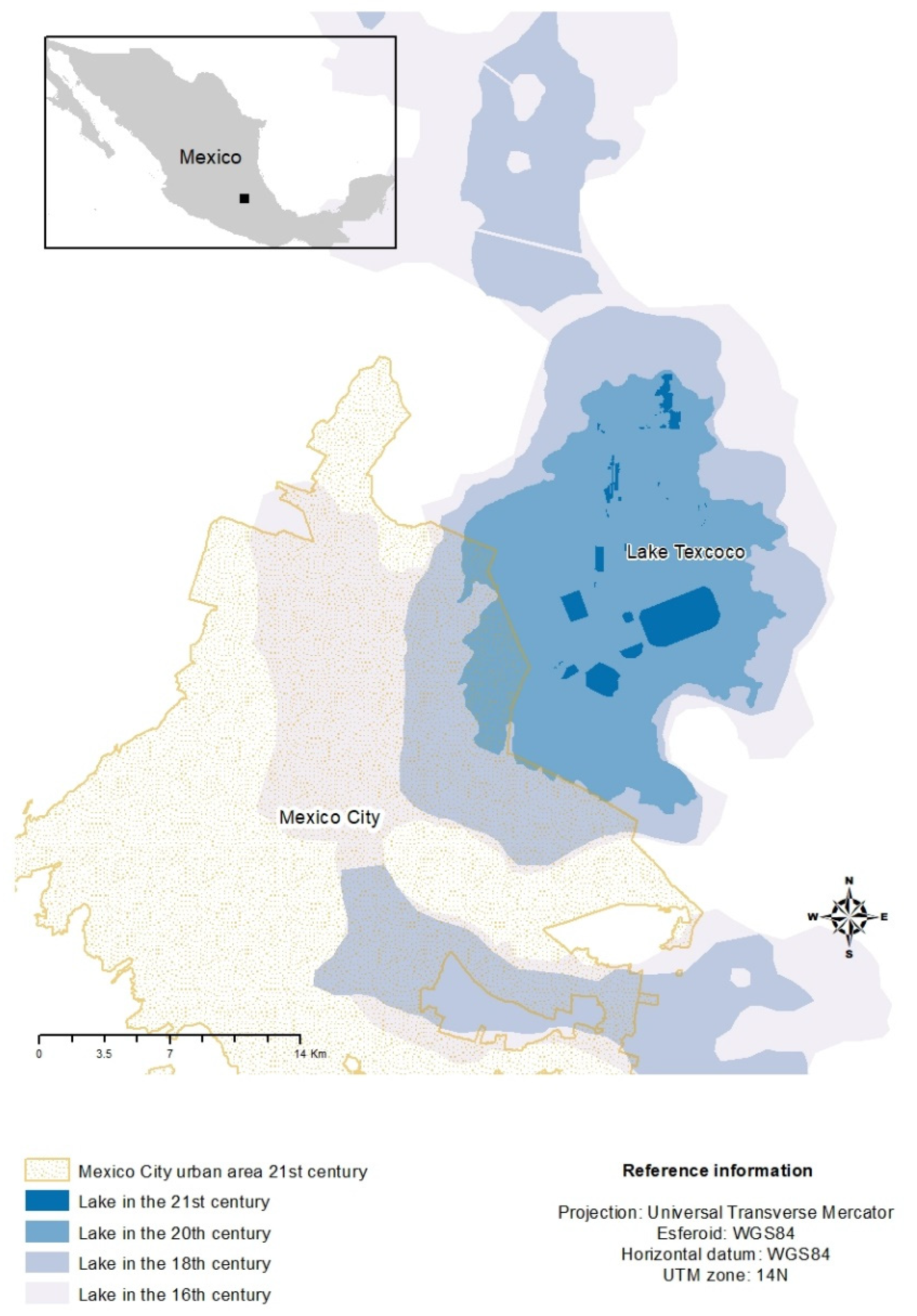
Although the floods continued, this project was critical for future urban expansion because it created new territory that could be salvaged by draining the waters of Lake Texcoco. The decrease in Lake Texcoco to its current extent and the urban area of Mexico City are depicted in
Figure 2.
4.4. Drainage of Mexico City in the Twentieth and Twenty-First Centuries: The Battle against the Lake Is Not Over
Efforts undertaken centuries ago to minimize flooding in Mexico were insufficient. The rapid growth of the city, constructed on a historic lake complex, prompted the development of increasingly complicated infrastructure. This would eventually impact the city’s hydraulic infrastructure, necessitating ongoing drainage projects and repair of current ones. Reyes [
41] writes about it:
“It covers the drying up of the valley from the year 1449 to the year 1900. Three races have worked in it, and almost three civilizations —that there is little in common between the viceregal organism and the prodigious political fiction that gave us thirty years of august peace. Three monarchical regimes, divided by parentheses of anarchy, are here an example of how the work of the State grows and corrects itself, in the face of the same threats from nature and the same earth to dig. The slogan of drying the earth appears to have run from Nezahualcóyotl to the second Luis de Velasco, and from him to Porfirio Díaz. Our century found us still throwing the last shovel and digging the last ditch”
(translation from Spanish)
The first Tequixquiac tunnel, inaugurated in 1900 by Porfirio Díaz, had a flow of 16 m 37 s; this was enough for Mexico City, which at that time had around 500,000 inhabitants and when the rivers that crossed it emptied into Lake Texcoco. Subsequently, the water discarded by the drainage system began to be used for irrigation of agricultural land, forming part of the irrigation district of Tula, Hidalgo in the Mezquital Valley region.
Only 37 years after the tunnel’s completion, it became insufficient to accommodate Mexico City’s population increase. By 1940, the city had grown to 1,757,530 inhabitants, and fearful of the first tunnel collapsing, the federal authorities decided to expand the system. Drainage was undertaken via a second tunnel through Ametlac ravine in Tequixquiac. The new tunnel would be the basin’s third artificial outlet.
The second tunnel began construction on 1 July 1937, initially under the supervision of the Ministry of Communications and Public Works and later transferred to the Ministry of Hydraulic Resources. It was opened in 1946 by President Manuel Avila Camacho and had a flow rate of 60 cubic meters per second, a diameter of 4 m, a length of 11.3 km, and a slope of two thousandths.
However, there was a tremendous ecological cost. These three exits contributed significantly to drainage of the lakes and rivers, hence reducing the risk of floods in the city. The loss of the natural balance of the hydraulic system occurred as a result of the artificial outlets. Since 1608, the drainage flow has increased without being matched by an equal amount of incoming water, compressing the subsoil clays and resulting in differential subsidence in the soil.
The sinking has impacted not only Mexico City, but also other areas of the old lake of Texcoco, with one of the repercussions being the shutdown of the drainage system. When the Grand Drainage Canal was launched, the city’s base was 5 m higher than it is now, the collectors had a sufficient slope, and the flow could be dragged to the Tequixquiac tunnel, but by 1950, the situation had changed. Water began to withdraw from the collectors and flood the streets as a result of the unevenness.
On 16 July 1951, the city center was flooded for months due to the drainage system’s inefficiency in removing rainwater. The water level reached two meters, and residents had to rely on boats to move around. The Hydrological Commission of the Valley of Mexico Basin recommended installing a system of pumps in the collectors to transport the water to the Grand Drainage Canal, a solution that would be costly due to the amount of electricity consumed.
The interceptor and west emitter were built in 1960 to receive and dislodge waters from the Nochistongo gorge. However, the city’s rapid and steady growth rendered it insufficient. Lake Texcoco was 2 m below the city center in 1900, but 5.5 m above it in 1970 [
36]. As a result, the federal government (Department of the Federal District) concluded, based on the findings of the General Directorate of Hydraulic Works investigations, that a drainage system was required that was not affected by subsidence and did not require the use of pumps, thereby lowering the cost of its operation. As the Tequixquiac tunnels were full, it was decided to build a fourth artificial outflow from the basin.
The first stage of the Deep Drainage System was built in 1967, during the presidency of Gustavo Díaz Ordaz, and was opened in 1975, with the government of Luis Echeverría. The first stage involved the construction of a 60 km tunnel with a 200 m depth and a discharge rate of up to 200 cubic meters per second. Luis Echeverría called this one of the century’s most important works, one that would finally free the city from flooding [
36].
An extension of 5.5 km to the central interceptor and a new interceptor of 16 km commenced during José López Portillo’s six-year administration (1976–1982). The Deep Drainage System has been extended to more distant parts of the city, as has the Grand Drainage Canal, thus using existing infrastructure and linking the entire city. Under Carlos Salinas de Gortari (1988–1994), the Deep Drainage System covered 125 km.
For a long time, the drainage system was solely meant to remove rainfall and was closed annually for repair. In the mid-1990s, a combination system that dislodges both rainfall and sewage began to be deployed. Drainage work has persisted throughout the first two decades of the twenty-first century since the city continues to have flooding issues connected to expansion and subsidence.
The Deep Drainage System was expanded under Felipe Calderón Hinojosa’s presidency. The East Emitter Tunnel (EET) was built in 2008 to increase system flexibility. In the municipality of Atotonilco de Tula in the state of Hidalgo, near the exit of the central emitter, the EET discharges up to 150 cubic meters per second. It is 62 km long, 7.5 m wide, and 55 to 150 m deep. A decade late and 20 million pesos over budget, it began operations in 2020. However, it is one of the world’s largest drainage works.
In 2014, under Enrique Peña Nieto’s administration, the first stage of the West II Emitter Tunnel was completed, reducing river overflows near Naucalpan, Tlalnepantla, Cuautitlán Izcalli, and Atizapán. It is 5573 km long, 12 to 110 m deep, and has a drainage capacity of 112 cubic meters per second. This project was nominated for Work of the Year in 2019 (see
Figure 2).
Lake Texcoco went from covering almost the entire basin, about 7868 square kilometers at its origin [
1], to 272.17 square kilometers in the mid-nineteenth century [
40] and at present, the remnants of the lake cover an area of only 16.83 square kilometers within the federal area (see
Figure 3).
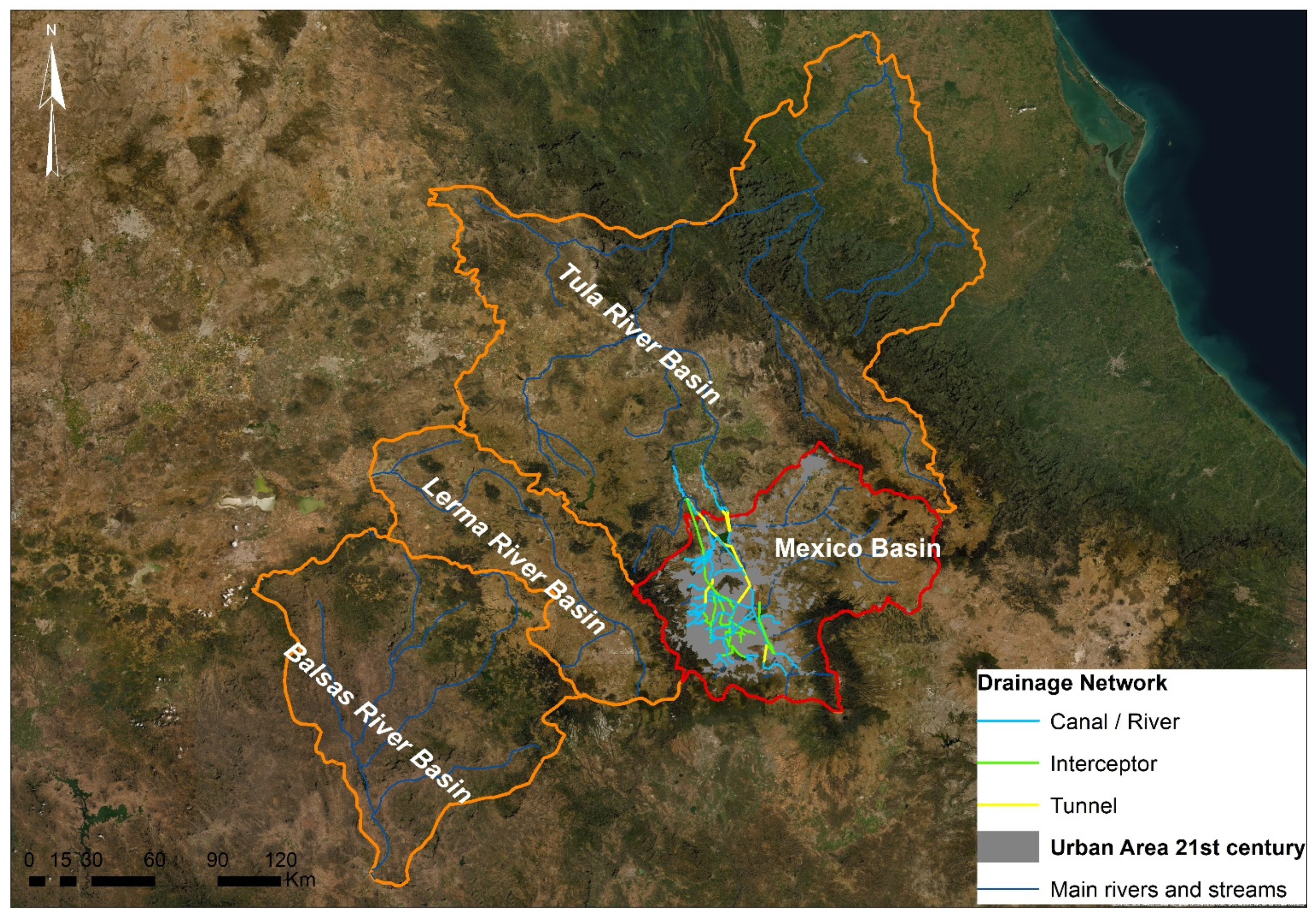
4.5. Recent Climate Change in Mexico Basin
Mexico City’s paradox is that it has built an artificial mega basin by importing water from the Lerma and Balsas basins to serve the city, while also expelling the waters through the constructed drainage system into the Tula basin (see
Figure 4). Additionally, the extraction of water from the subsoil has resulted in the city sinking lower than the lake in respect to the difference from the place where it was located in pre-Hispanic times, leading to the burying of the city drainage deeper and deeper [
45].
The delivery record of Cutzamala system (in the Balsas river basin) to Mexico Basin shows that, for the period 1997–2008, the average import was 15,162 cubic meters per second, while the corresponding record of the Lerma system shows that the respective import supply to the basin was 4231 cubic meters per second [
46].
The ejected water is directed to irrigation district 003 in Tula, Hidalgo, which covers approximately 50,000 hectares and produces mostly corn (
Zea mays) and alfalfa (
Medicago sativa) [
47] and, for the years 1989–1992, the yearly amount of exports to the Tula basin was 52,782 cubic meters per second [
46]. It should be emphasized that Mexico City’s and the metropolitan area’s drainage system is of the combined sort (wastewater and rainwater), and that drainage expansion has continued in recent years, as has its water expulsion capacity.
The Intergovernmental Panel on Climate Change (IPCC) anticipates that both environmental humidity and global temperature will increase [
48]. Mexico City’s transformation as a result of human-induced changes has resulted in an increase in the frequency and intensity of extreme events such as floods, droughts, and heat waves. According to Romero Lankao [
49] between 1980 and 2006, there were 668 floods, 60 storms, 53 showers, 60 hail storms, 85 fires, and 14 droughts.
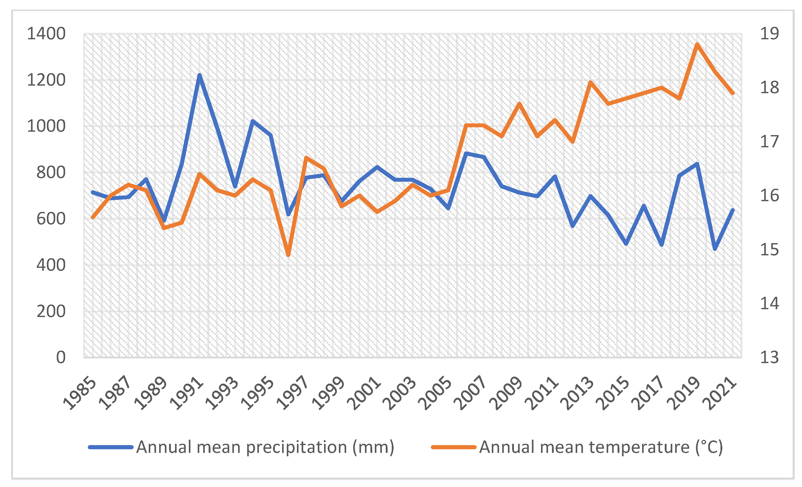
The National Water Commission’s (CONAGUA) records on annual mean precipitation and annual mean temperature over the previous 37 years [
50] indicate a decline in the amount of rainfall occurring in Mexico City annually and, in turn, an increase can be observed in the mean annual temperature (
Figure 5).
Between 1920 and 1940, the Basin of Mexico had substantial population increase, particularly after 1940, and peripheral areas have been absorbed into the megalopolis. The forests and agricultural fields have vanished entirely, while there still exist portions of the lakes in the basin’s south, they are endangered due to the pressures of urban water requirements.
According to Ezcurra et al. [
45], numerous aquatic, subaquatic, and halophilic species have become extinct, while other types of vegetation are on the edge of extinction. Forest communities have been deeply affected in general; since 1985 over 9000 hectares of forest have been lost, and those that remain are threatened by pollution and pests. On the other hand, the introduction of exotic species to the basin’s forests has resulted in the extinction of animal species that rely on indigenous plants for food and shelter. Eucalyptus trees, in particular, were planted extensively throughout the basin to increase evaporation and accelerate the lacustrine system’s desiccation process.
A study of changes in annual mean precipitation and temperature from 1950 to 2013 [
51] indicated that average winter temperature and summer precipitation increased at an average rate of 0.1 degree Celsius per decade and 17.8 mm per decade, respectively. They forecast a temperature increase of between 1 and 3 degrees Celsius over the next 30 years, while rainfall is expected to increase and become more severe at the conclusion of the rainy season.
Clearly, the lake was abandoned in favor of urbanization. Following the Mexican Revolution, and particularly under Lázaro Cárdenas’s (1934–1940) land reform, the desiccated territory surrounding Lake Texcoco was targeted for agriculture. They did not realize, however, that the fertility of the flooded land was attributable to the lake’s presence.
Additionally, considerable efforts were made to restore what remains on the dry bottom of the former Lake Texcoco. CONAGUA initiated a program in the 1970s to plant halophytes on the lake’s ancient bed in order to mitigate dust storms that afflicted the eastern part of Mexico’s basin during the dry season. To retain a portion of the lake’s ecological functions, a series of artificial lagoons with a combined surface area of 17 square kilometers were constructed. However, the government lost interest in this program, and for the last two decades, there has been a lot of debate about what to do with that area.


 ,
, 


