
Managing Wildfire Risk in Mosaic Landscapes: A Case Study of the Upper Gata River Catchment in Sierra de Gata, Spain


Abstract
:1. Introduction
1.1. New Forests, Shifting Fire Regimes
1.2. Socio-Economic and Environmental Impacts of Wildfires
1.3. Approaches to Fire Risk Management
2. Materials and Methods
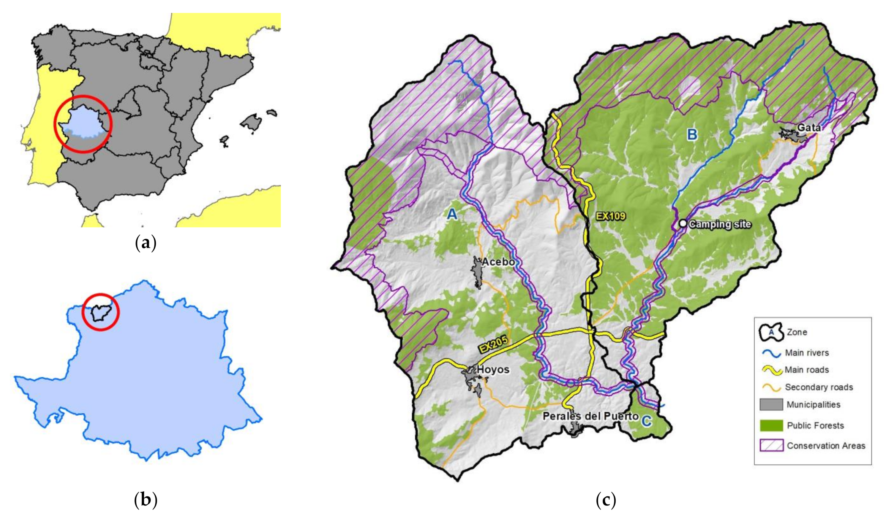
2.1. Study Site
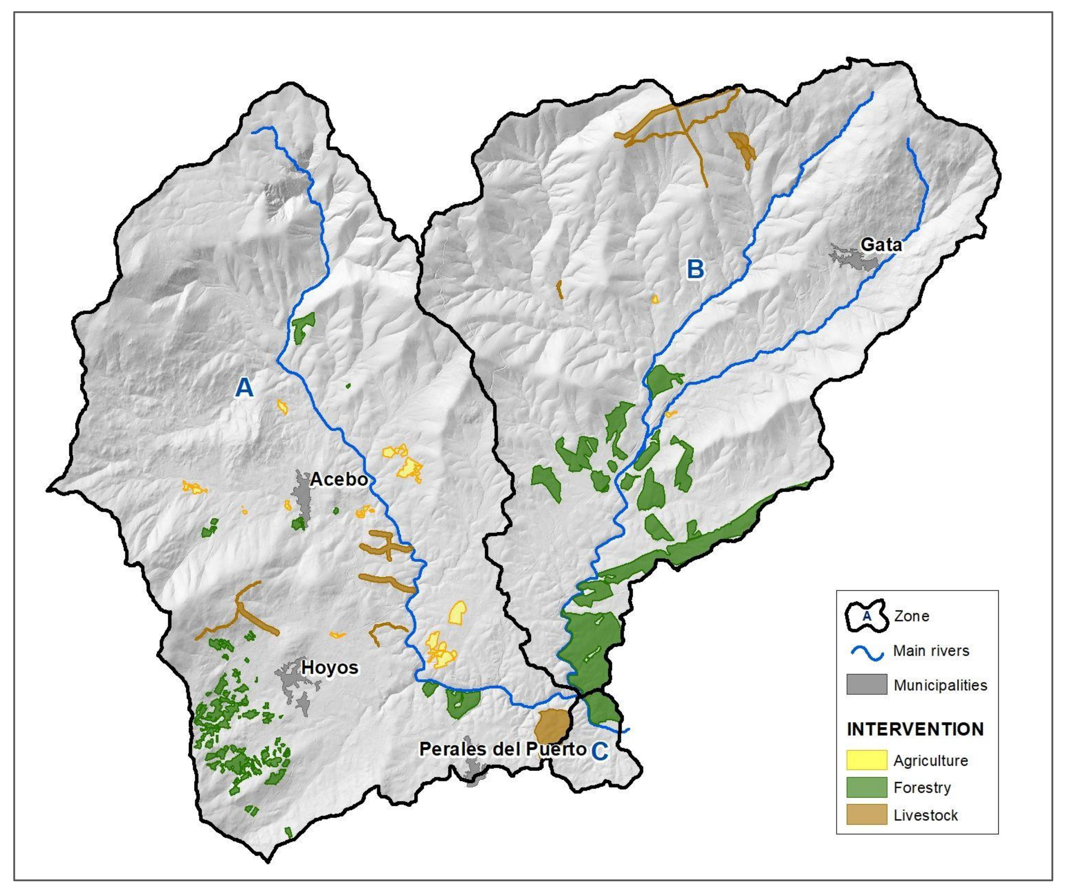
2.2. Description of the Mosaico-Extremadura (Mosaico) Project
2.3. Data Collection
2.4. Data Analysis
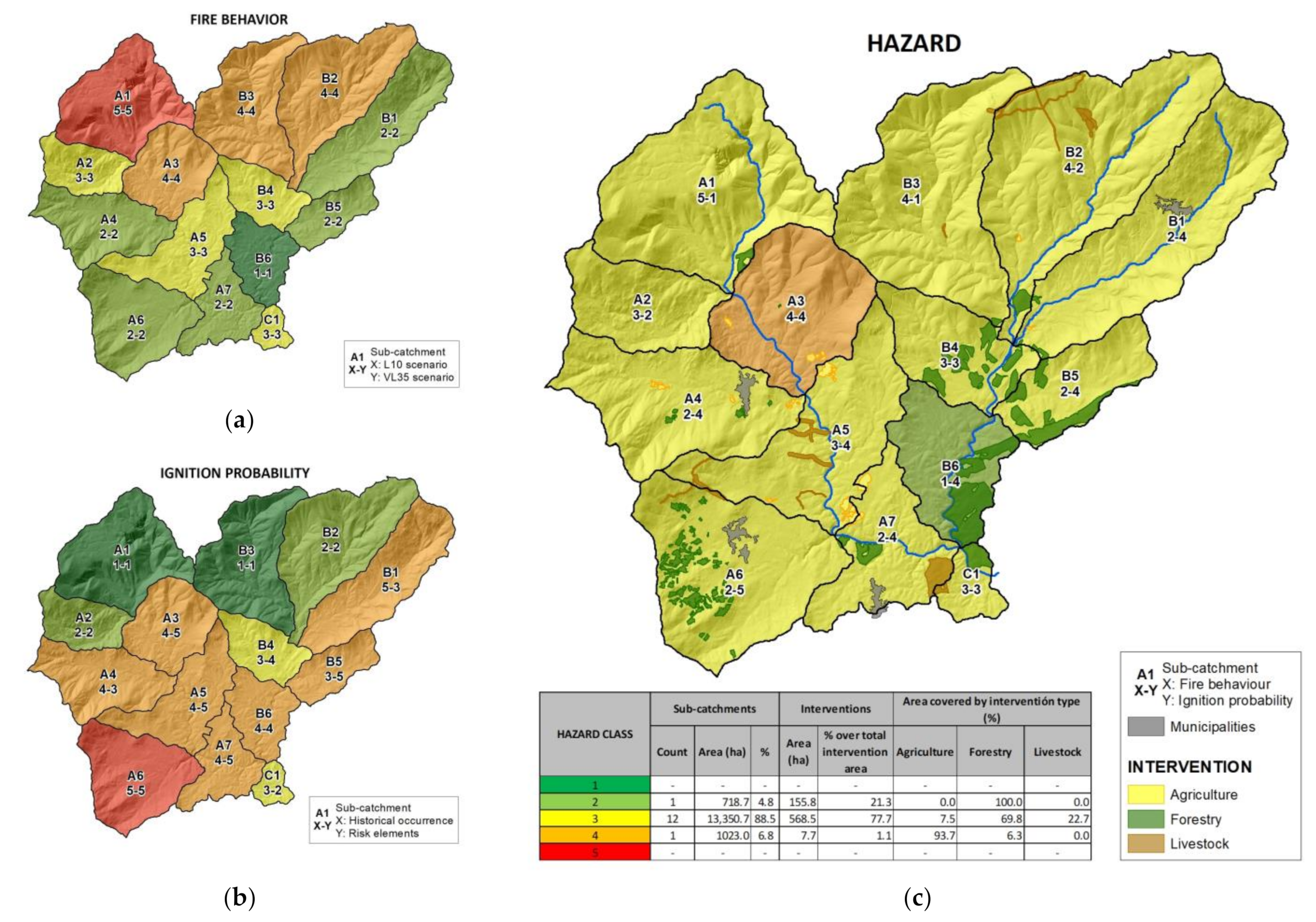
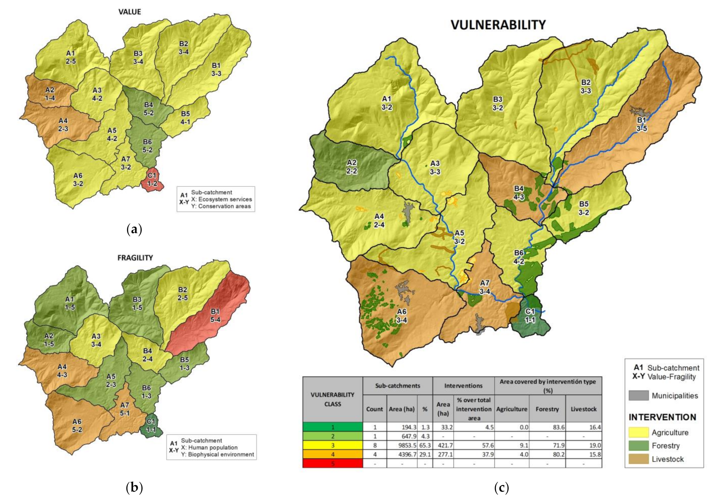
2.5. Risk Analysis
3. Results
3.1. Efficacy of the Interventions as “Productive Firebreaks”
3.2. Risk Analysis
4. Discussion
Further Research
5. Conclusions
Supplementary Materials
Author Contributions
Funding
Institutional Review Board Statement
Informed Consent Statement
Data Availability Statement
Acknowledgments
Conflicts of Interest
References
- Lewis, H.T. The Role of Fire in the Domestication of Plants and Animals in Southwest Asia: A Hypothesis. Man 1972, 7, 195–222. [Google Scholar]
- Pyne, S.J. Fire in the mind: Changing understandings of fire in Western civilization. Philos. Trans. R. Soc. B Biol. Sci. 2016, 371, 20150166. [Google Scholar] [CrossRef] [Green Version]
- Pausas, J.; Keeley, J.E. A Burning Story: The Role of Fire in the History of Life. BioScience 2009, 59, 593–601. [Google Scholar] [CrossRef] [Green Version]
- Bowman, D.M.J.S.; Balch, J.; Artaxo, P.; Bond, W.J.; Cochrane, M.A.; D’Antonio, C.M.; DeFries, R.; Johnston, F.H.; Keeley, J.E.; Krawchuk, M.A.; et al. The human dimension of fire regimes on Earth. J. Biogeogr. 2011, 38, 2223–2236. [Google Scholar] [CrossRef] [PubMed] [Green Version]
- Krebs, P.; Pezzatti, G.B.; Mazzoleni, S.; Talbot, L.M.; Conedera, M. Fire regime: History and definition of a key concept in disturbance ecology. Theory Biosci. 2010, 129, 53–69. [Google Scholar] [CrossRef] [Green Version]
- Noble, I.R.; Dirzo, R. Forests as Human-Dominated Ecosystems. Science 1997, 277, 522–525. [Google Scholar] [CrossRef] [Green Version]
- Marlon, J.R.; Bartlein, P.J.; Gavin, D.G.; Long, C.J.; Anderson, R.S.; Briles, C.E.; Brown, K.J.; Colombaroli, D.; Hallett, D.J.; Power, M.J.; et al. Long-term perspective on wildfires in the western USA. Proc. Natl. Acad. Sci. USA 2012, 109, E535–E543. [Google Scholar] [CrossRef] [Green Version]
- Meyfroidt, P.; Lambin, E.F. Global Forest Transition: Prospects for an End to Deforestation. Annu. Rev. Environ. Resour. 2011, 36, 343–371. [Google Scholar] [CrossRef]
- Kelley, D.I.; Bistinas, I.; Whitley, R.; Burton, C.; Marthews, T.R.; Dong, N. How contemporary bioclimatic and human controls change global fire regimes. Nat. Clim. Chang. 2019, 9, 690–696. [Google Scholar] [CrossRef] [Green Version]
- Flannigan, M.D.; Krawchuk, M.A.; De Groot, W.J.; Wotton, B.M.; Gowman, L.M. Implications of changing climate for global wildland fire. Int. J. Wildland Fire 2009, 18, 483–507. [Google Scholar] [CrossRef]
- Westerling, A.L.; Hidalgo, H.G.; Cayan, D.R.; Swetnam, T.W. Warming and Earlier Spring Increase Western U.S. Forest Wildfire Activity. Science 2006, 313, 940–943. [Google Scholar] [CrossRef] [PubMed] [Green Version]
- Giannakopoulos, C.; Le Sager, P.; Bindi, M.; Moriondo, M.; Kostopoulou, E.; Goodess, C. Climatic changes and associated impacts in the Mediterranean resulting from a 2 °C global warming. Glob. Planet. Chang. 2009, 68, 209–224. [Google Scholar] [CrossRef]
- Bradstock, R.A. A biogeographic model of fire regimes in Australia: Current and future implications. Glob. Ecol. Biogeogr. 2010, 19, 145–158. [Google Scholar] [CrossRef]
- Aldersley, A.; Murray, S.J.; Cornell, S. Global and regional analysis of climate and human drivers of wildfire. Sci. Total Environ. 2011, 409, 3472–3481. [Google Scholar] [CrossRef]
- Sousa, P.M.; Trigo, R.M.; Pereira, M.G.; Bedia, J.; Gutiérrez, J.M. Different approaches to model future burnt area in the Iberian Peninsula. Agric. For. Meteorol. 2015, 202, 11–25. [Google Scholar] [CrossRef]
- Hagmann, R.K.; Hessburg, P.F.; Prichard, S.J.; Povak, N.A.; Brown, P.M.; Ful, P.Z.; Keane, R.E.; Knapp, E.E.; Lydersen, J.M.; Metlen, K.L.; et al. Evidence for Widespread Changes in the Structure, Composition, and Fire Regimes of Western North American Forests invited feature: Climate change and western wildfires. Ecol. Appl. 2021, 31, 2431. [Google Scholar] [CrossRef]
- Keenan, R.J.; Reams, G.A.; Achard, F.; de Freitas, J.V.; Grainger, A.; Lindquist, E. Dynamics of Global Forest Area: Results from the FAO Global Forest Resources Assessment 2015. In Forest Ecology and Management; Elsevier: Amsterdam, The Netherlands, 8 September 2015; pp. 9–20. [Google Scholar] [CrossRef]
- Mather, A. The transition from deforestation to reforestation in Europe. In Agricultural Technologies and Tropical Deforestation; CABI: Wallingford, UK, 2001. [Google Scholar] [CrossRef]
- Martín-Forés, I.; Magro, S.; Bravo-Oviedo, A.; Alfaro-Sánchez, R.; Espelta, J.M.; Frei, T.; Valdés-Correcher, E.; Fernández-Blanco, C.R.; Winkel, G.; Gerzabek, G.; et al. Spontaneous forest regrowth in South-West Europe: Consequences for nature’s contributions to people. People Nat. 2020, 2, 980–994. [Google Scholar] [CrossRef]
- Vadell, E.; De-Miguel, S.; Pemán, J. Large-scale reforestation and afforestation policy in Spain: A historical review of its underlying ecological, socioeconomic and political dynamics. Land Use Policy 2016, 55, 37–48. [Google Scholar] [CrossRef]
- European Environment Agency. Briefing. Forests. Available online: https://www.eea.europa.eu/soer/2015/europe/forests (accessed on 9 November 2021).
- Eurostat. Over 40% of the EU Covered with Forests. Available online: https://ec.europa.eu/eurostat/web/products-eurostat-news/-/EDN-20180321-1 (accessed on 9 November 2021).
- Gregow, H.; Laaksonen, A.; Alper, M.E. Increasing large scale windstorm damage in Western, Central and Northern European forests, 1951–2010. Sci. Rep. 2017, 7, srep46397. [Google Scholar] [CrossRef] [Green Version]
- Marini, L.; Økland, B.; Jönsson, A.M.; Bentz, B.J.; Carroll, A.; Forster, B.; Grégoire, J.-C.; Hurling, R.; Nageleisen, L.M.; Netherer, S.; et al. Climate drivers of bark beetle outbreak dynamics in Norway spruce forests. Ecography 2017, 40, 1426–1435. [Google Scholar] [CrossRef]
- Cheryl Katz. Small Pests, Big Problems: The Global Spread of Bark Beetles. Available online: https://e360.yale.edu/features/small-pests-big-problems-the-globalspread-of-bark-beetles (accessed on 9 November 2021).
- Hlásny, T.; Turčáni, M. Persisting bark beetle outbreak indicates the unsustainability of secondary Norway spruce forests: Case study from Central Europe. Ann. For. Sci. 2013, 70, 481–491. [Google Scholar] [CrossRef] [Green Version]
- Lynch, H.J.; Renkin, R.A.; Crabtree, R.L.; Moorcroft, P.R. The Influence of Previous Mountain Pine Beetle (Dendroctonus ponderosae) Activity on the 1988 Yellowstone Fires. Ecosystems 2006, 9, 1318–1327. [Google Scholar] [CrossRef]
- Page, W.G.; Jenkins, M.J. Mountain Pine Beetle-Induced Changes to Selected Lodgepole Pine Fuel Complexes within the Intermountain Region. For. Sci. 2007, 53, 507–518. Available online: https://academic.oup.com/forestscience/article/53/4/507/4604067 (accessed on 9 November 2021).
- Román, M.V.; Azqueta, D.; Rodrígues, M. Methodological approach to assess the socio-economic vulnerability to wildfires in Spain. For. Ecol. Manag. 2013, 294, 158–165. [Google Scholar] [CrossRef]
- Novo, A.; Fariñas-Álvarez, N.; Martínez-Sánchez, J.; González-Jorge, H.; Fernández-Alonso, J.; Lorenzo, H. Mapping Forest Fire Risk—A Case Study in Galicia (Spain). Remote Sens. 2020, 12, 3705. [Google Scholar] [CrossRef]
- Wu, C.; Venevsky, S.; Sitch, S.; Mercado, L.M.; Huntingford, C.; Staver, A.C. Historical and future global burned area with changing climate and human demography. One Earth 2021, 4, 517–530. [Google Scholar] [CrossRef]
- Ager, A.A.; Preisler, H.K.; Arca, B.; Spano, D.; Salis, M. Wildfire risk estimation in the Mediterranean area. Environmetrics 2014, 25, 384–396. [Google Scholar] [CrossRef]
- Narayanaraj, G.; Wimberly, M. Influences of forest roads on the spatial patterns of human- and lightning-caused wildfire ignitions. Appl. Geogr. 2012, 32, 878–888. [Google Scholar] [CrossRef]
- Thompson, M.P.; Gannon, B.M.; Caggiano, M.D. Forest Roads and Operational Wildfire Response Planning. Forests 2021, 12, 110. [Google Scholar] [CrossRef]
- Arienti, M.C.; Cumming, S.G.; Krawchuk, M.A.; Boutin, S. Road network density correlated with increased lightning fire incidence in the Canadian western boreal forest. Int. J. Wildland Fire 2009, 18, 970–982. [Google Scholar] [CrossRef]
- Ricotta, C.; Bajocco, S.; Guglietta, D.; Conedera, M. Assessing the Influence of Roads on Fire Ignition: Does Land Cover Matter? Fire 2018, 1, 24. [Google Scholar] [CrossRef] [Green Version]
- Catry, F.X.; Rego, F.C.; Bacao, F.; Moreira, F. Modeling and mapping wildfire ignition risk in Portugal. Int. J. Wildland Fire 2009, 18, 921–931. [Google Scholar] [CrossRef] [Green Version]
- Vacchiano, G.; Foderi, C.; Berretti, R.; Marchi, E.; Motta, R. Modeling anthropogenic and natural fire ignitions in an inner-alpine valley. Nat. Hazards Earth Syst. Sci. 2018, 18, 935–948. [Google Scholar] [CrossRef] [Green Version]
- Ganteaume, A.; Jappiot, M. What causes large fires in Southern France. For. Ecol. Manag. 2012, 294, 76–85. [Google Scholar] [CrossRef] [Green Version]
- Pastor, E.; Muñoz, J.A.; Caballero, D.; Àgueda, A.; Dalmau, F.; Planas, E. Wildland–Urban Interface Fires in Spain: Summary of the Policy Framework and Recommendations for Improvement. Fire Technol. 2019, 56, 1831–1851. [Google Scholar] [CrossRef]
- Wang, D.; Guan, D.; Zhu, S.; Mac Kinnon, M.; Geng, G.; Zhang, Q.; Zheng, H.; Lei, T.; Shao, S.; Gong, P.; et al. Economic footprint of California wildfires in 2018. Nat. Sustain. 2020, 4, 252–260. [Google Scholar] [CrossRef]
- The Burning Issue: Managing Wildfire Risk. Available online: https://www.mmc.com/content/dam/mmc-web/insights/publications/2019/oct/The.Burning.Issue-Managing.Wildfire.Risk.final2.pdf (accessed on 9 November 2021).
- Raftoyannis, Y.; Nocentini, S.; Marchi, E.; Sainz, R.C.; Guemes, C.G.; Pilas, I.; Peric, S.; Paulo, J.A.; Moreira-Marcelino, A.C.; Costa-Ferreira, M.; et al. Perceptions of forest experts on climate change and fire management in European Mediterranean forests. iFor. Biogeosci. For. 2014, 7, 33–41. [Google Scholar] [CrossRef] [Green Version]
- Molina-Terrén, D.M.; Xanthopoulos, G.; Diakakis, M.; Ribeiro, L.; Caballero, D.; Delogu, G.M.; Viegas, D.; Silva, C.A.; Cardil, A. Analysis of forest fire fatalities in Southern Europe: Spain, Portugal, Greece and Sardinia (Italy). Int. J. Wildland Fire 2019, 28, 85. [Google Scholar] [CrossRef] [Green Version]
- Cardil, A.; Molina-Terren, D. Factors Causing Victims of Wildland Fires in Spain (1980–2010). Hum. Ecol. Risk Assess. Int. J. 2014, 21, 67–80. [Google Scholar] [CrossRef]
- Turco, M.; Jerez, S.; Augusto, S.; Tarín-Carrasco, P.; Ratola, N.; Jiménez-Guerrero, P.; Trigo, R. Climate drivers of the 2017 devastating fires in Portugal. Sci. Rep. 2019, 9, 13886. [Google Scholar] [CrossRef]
- Guo, M.; Li, J.; Wen, L.; Huang, S. Estimation of CO2 Emissions from Wildfires Using OCO-2 Data. Atmosphere 2019, 10, 581. [Google Scholar] [CrossRef] [Green Version]
- Randerson, J.T.; Chen, Y.; van der Werf, G.R.; Rogers, B.M.; Morton, D.C. Global burned area and biomass burning emissions from small fires. J. Geophys. Res. Biogeosci. 2012, 117, 1–23. [Google Scholar] [CrossRef]
- Ribeiro-Kumara, C.; Köster, E.; Aaltonen, H.; Köster, K. How do forest fires affect soil greenhouse gas emissions in upland boreal forests? A review. Environ. Res. 2020, 184, 109328. [Google Scholar] [CrossRef]
- Zaimes, G.N.; Tsioras, P.; Kiosses, C.; Tufekcioglu, M.; Zibtsev, S.; Trombitsky, I.; Uratu, R.; Gevorgyan, L. Perspectives on protected area and wildfire management in the Black Sea region. J. For. Res. 2020, 31, 257–268. [Google Scholar] [CrossRef]
- Secretariat of the Convention on Biological Diversity; Center for International Forestry Research. Impacts of Human-Caused Fires on Biodiversity and Ecosystem Functioning, and Their Causes in Tropical, Temperate, and Boreal Forest Biomes; Secretariat of the Convention on Biological Diversity, Ed.; CBD Technical Series no. 5; SCBD: Montreal, QC, Canada, 2001; 42p. [Google Scholar]
- Urbieta, I.R.; Franquesa, M.; Viedma, O.; Moreno, J.M. Fire activity and burned forest lands decreased during the last three decades in Spain. Ann. For. Sci. 2019, 76, 90. [Google Scholar] [CrossRef]
- Syphard, A.D.; Keeley, J.E.; Brennan, T.J. Factors affecting fuel break effectiveness in the control of large fires on the Los Padres National Forest, California. Int. J. Wildland Fire 2011, 20, 764–775. [Google Scholar] [CrossRef]
- Stephens, S.L.; Burrows, N.; Buyantuyev, A.; Gray, R.W.; Keane, R.E.; Kubian, R.; Liu, S.; Seijo, F.; Shu, L.; Tolhurst, K.G.; et al. Temperate and boreal forest mega-fires: Characteristics and challenges. Front. Ecol. Environ. 2014, 12, 115–122. [Google Scholar] [CrossRef] [Green Version]
- Turner, M.G.; Romme, W.H.; Tinker, D.B. Surprises and Lessons from the 1988 Yellowstone Fires. Front. Ecol. Environ. 2003, 1, 351–358. [Google Scholar] [CrossRef]
- Myers, R.L. Living with Fire-Sustaining Ecosystems & Livelihoods Through Integrated Fire Management; Global Fire Initiative: Tallahassee, FL, USA, 2006. [Google Scholar]
- Stephens, S.L.; McIver, J.D.; Boerner, R.E.J.; Fettig, C.J.; Fontaine, J.B.; Hartsough, B.R.; Kennedy, P.L.; Schwilk, D.W. The Effects of Forest Fuel-Reduction Treatments in the United States. BioScience 2012, 62, 549–560. [Google Scholar] [CrossRef] [Green Version]
- Russell-Smith, J.; Cook, G.D.; Cooke, P.M.; Edwards, A.C.; Lendrum, M.; Meyer, C.P.; Whitehead, P.J. Managing fire regimes in north Australian savannas: Applying Aboriginal approaches to contemporary global problems. Front. Ecol. Environ. 2013, 11, e55–e63. [Google Scholar] [CrossRef] [Green Version]
- Schmidt, I.B.; Moura, L.C.; Ferreira, M.C.; Eloy, L.; Sampaio, A.B.; Dias, P.A.; Berlinck, C.N. Fire management in the Brazilian savanna: First steps and the way forward. J. Appl. Ecol. 2018, 55, 2094–2101. [Google Scholar] [CrossRef] [Green Version]
- Kobziar, L.N.; Godwin, D.; Taylor, L.; Watts, A.C. Perspectives on Trends, Effectiveness, and Impediments to Prescribed Burning in the Southern U.S. Forests 2015, 6, 561–580. [Google Scholar] [CrossRef] [Green Version]
- Haines, T.K.; Busby, R.L.; Cleaves, D.A. Prescribed Burning in the South: Trends, Purpose, and Barriers. South. J. Appl. For. 2001, 25, 149–153. [Google Scholar] [CrossRef] [Green Version]
- Rego, F.; Rigolot, E.; Fernandes, P.; Montiel, C.; Silva, J.S.; Sande, J.; Towards, S. Towards Integrated Fire Management; European Forest Institute: Joensuu, Finland, 2010; p. 16. ISBN 978-952-5453-48-5. Available online: https://hal.inrae.fr/hal-02823739 (accessed on 3 March 2022).
- Spies, T.A.; White, E.M.; Kline, J.D.; Fischer, A.P.; Ager, A.; Bailey, J.; Bolte, J.; Koch, J.; Platt, E.; Olsen, C.S.; et al. Examining fire-prone forest landscapes as coupled human and natural systems. Ecol. Soc. 2014, 19, 9. [Google Scholar] [CrossRef] [Green Version]
- Fischer, A.P. Forest landscapes as social-ecological systems and implications for management. Landsc. Urban Plan. 2018, 177, 138–147. [Google Scholar] [CrossRef]
- Spies, T.A.; Scheller, R.; Bolte, J.P. Adaptation in fire-prone landscapes: Interactions of policies, management, wildfire, and social networks in Oregon, USA. Ecol. Soc. 2018, 23, 11. [Google Scholar] [CrossRef]
- Swanson, F.J.; Chapin, F.S. Forest Systems: Living with Long-Term Change. In Principles of Ecosystem Stewardship; Springer: New York, NY, USA, 2009; pp. 149–170. [Google Scholar] [CrossRef]
- Tedim, F.; Leone, V.; Xanthopoulos, G. A wildfire risk management concept based on a social-ecological approach in the European Union: Fire Smart Territory. Int. J. Disaster Risk Reduct. 2016, 18, 138–153. [Google Scholar] [CrossRef]
- Carroll, M.S.; Blatner, K.A.; Cohn, P.J.; Morgan, T. Managing Fire Danger in the Forests of the US Inland Northwest: A Classic “Wicked Problem” in Public Land Policy. J. For. 2007, 105, 239–244. [Google Scholar]
- Head, B.W. Wicked Problems in Public Policy; Springer Nature: Cham, Switzerland, 2022; Volume 3, pp. 101–118. [Google Scholar] [CrossRef]
- Gerald Allen, B.M.; Gould, E.M. Complexity, Wickedness, and Public Forests. J. For. 1987, 84, 20–23. [Google Scholar]
- Balint, P.J.; Stewart, R.E.; Desai, A.; Walters, L.C. Wicked Environmental Problems; Island Press: Washington, DC, USA; Center for Resource Economics: Raleigh, NC, USA, 2011. [Google Scholar] [CrossRef]
- DeFries, R.; Nagendra, H. Ecosystem management as a wicked problem. Science 2017, 356, 265–270. [Google Scholar] [CrossRef]
- Otero, I.; Nielsen, J.Ø. Coexisting with wildfire? Achievements and challenges for a radical social-ecological transformation in Catalonia (Spain). Geoforum 2017, 85, 234–246. [Google Scholar] [CrossRef]
- Urgenson, L.S.; Ryan, C.M.; Halpern, C.B.; Bakker, J.D.; Belote, R.T.; Franklin, J.F.; Haugo, R.D.; Nelson, C.R.; Waltz, A.E. Visions of Restoration in Fire-Adapted Forest Landscapes: Lessons from the Collaborative Forest Landscape Restoration Program. Environ. Manag. 2016, 59, 338–353. [Google Scholar] [CrossRef]
- Chiasson, G.; Angelstam, P.; Axelsson, R.; Doyon, F. Towards collaborative forest planning in Canadian and Swedish hinterlands: Different institutional trajectories? Land Use Policy 2019, 83, 334–345. [Google Scholar] [CrossRef]
- Palsa, E.; Bauer, M.; Evers, C.; Hamilton, M.; Nielsen-Pincus, M. Engagement in local and collaborative wildfire risk mitigation planning across the western U.S.—Evaluating participation and diversity in Community Wildfire Protection Plans. PLoS ONE 2022, 17, e0263757. [Google Scholar] [CrossRef]
- Stuart Chapin Iii, F.; Trainor, S.F.; Huntington, O.; Lovecraft, A.L.; Zavaleta, E.; Natcher, D.C.; David Mcguire, A.; Nelson, J.L.; Ray, L.; Calef, M.; et al. Increasing Wildfire in Alaska’s Boreal Forest: Pathways to Potential Solutions of a Wicked Problem. BioScience 2008, 58, 531–540. [Google Scholar]
- Berkes, F. Devolution of environment and resources governance: Trends and future. Environ. Conserv. 2010, 37, 489–500. [Google Scholar] [CrossRef]
- Reed, M.S. Stakeholder participation for environmental management: A literature review. Biol. Conserv. 2008, 141, 2417–2431. [Google Scholar] [CrossRef]
- Blumenthal, D.; Jannink, J.L. A Classification of Collaborative Management Methods. Conserv. Ecol. 2000, 4, 13. Available online: http://www.consecol.org/vol4/iss2/art13/ (accessed on 2 March 2022).
- Sparking Firesmart Policies in the EU. Available online: https://doi.org/10.2777/248004 (accessed on 2 March 2022).
- Steelman, T. U.S. wildfire governance as social-ecological problem. Ecol. Soc. 2016, 21, 3. [Google Scholar] [CrossRef] [Green Version]
- Lasanta, T.; Khorchani, M.; Pérez-Cabello, F.; Errea, P.; Sáenz-Blanco, R.; Nadal-Romero, E. Clearing shrubland and extensive livestock farming: Active prevention to control wildfires in the Mediterranean mountains. J. Environ. Manag. 2018, 227, 256–266. [Google Scholar] [CrossRef]
- Varela, E.; Górriz-Mifsud, E.; Ruiz-Mirazo, J.; López-I-Gelats, F. Payment for Targeted Grazing: Integrating Local Shepherds into Wildfire Prevention. Forests 2018, 9, 464. [Google Scholar] [CrossRef] [Green Version]
- European Forum on Nature Conservation and Pastoralism. Available online: https://www.efncp.org/ (accessed on 10 March 2022).
- Otero, I.; Castellnou, M.; González, I.; Arilla, E.; Castell, L.; Castellví, J.; Sánchez, F.; Nielsen, J. Democratizing wildfire strategies. Do you realize what it means? Insights from a participatory process in the Montseny region (Catalonia, Spain). PLoS ONE 2018, 13, e0204806. [Google Scholar] [CrossRef] [Green Version]
- Rodríguez-Carreras, R.; Úbeda, X.; Francos, M.; Marco, C. After the Wildfires: The Processes of Social Learning of Forest Owners’ Associations in Central Catalonia, Spain. Sustainability 2020, 12, 6042. [Google Scholar] [CrossRef]
- Alcasena, F.J.; Ager, A.A.; Bailey, J.D.; Pineda, N.; Vega-García, C. Towards a comprehensive wildfire management strategy for Mediterranean areas: Framework development and implementation in Catalonia, Spain. J. Environ. Manag. 2018, 231, 303–320. [Google Scholar] [CrossRef]
- Castellnou, M.; Prat-Guitart, N.; Arilla, E.; Larrañaga, A.; Nebot, E.; Castellarnau, X.; Vendrell, J.; Pallàs, J.; Herrera, J.; Monturiol, M.; et al. Empowering strategic decision-making for wildfire management: Avoiding the fear trap and creating a resilient landscape. Fire Ecol. 2019, 15, 1–17. [Google Scholar] [CrossRef]
- Tàbara, D.; Saurí, D.; Cerdan, R. Forest fire risk management and public participation in changing socioenvironmental conditions: A case study in a Mediterranean region. Risk Anal. 2003, 23, 249–260. [Google Scholar] [CrossRef]
- Mosaico Extremadura. Available online: https://www.mosaicoextremadura.es/en/the-project/ (accessed on 15 July 2021).
- Pulido, F. Hacia los territorios inteligentes frente a incendios forestales. Ciudades 2021, 24, 65–78. [Google Scholar] [CrossRef]
- Ruiz-Mirazo, J.; Robles, A.B.; González-Rebollar, J.L. Two-year evaluation of fuelbreaks grazed by livestock in the wildfire prevention program in Andalusia (Spain). Agric. Ecosyst. Environ. 2011, 141, 13–22. [Google Scholar] [CrossRef]
- Colantoni, A.; Egidi, G.; Quaranta, G.; D’Alessandro, R.; Vinci, S.; Turco, R.; Salvati, L. Sustainable Land Management, Wildfire Risk and the Role of Grazing in Mediterranean Urban-Rural Interfaces: A Regional Approach from Greece. Land 2020, 9, 21. [Google Scholar] [CrossRef] [Green Version]
- Mancilla-Leytón, J.M.; Martín Vicente, A. Un Método Natural Para La Prevención de Incendio: Evaluación Del Efecto Del Pastoreo Sobre El Biocombustible Acumulado. For. Syst. 2012, 21, 199–204. [Google Scholar] [CrossRef] [Green Version]
- Damianidis, C.; Santiago-Freijanes, J.J.; Herder, M.D.; Burgess, P.; Mosquera-Losada, M.R.; Graves, A.; Papadopoulos, A.; Pisanelli, A.; Camilli, F.; Rois-Díaz, M.; et al. Agroforestry as a sustainable land use option to reduce wildfires risk in European Mediterranean areas. Agrofor. Syst. 2020, 95, 1–11. [Google Scholar] [CrossRef]
- Moreira, F.; Viedma, O.; Arianoutsou, M.; Curt, T.; Koutsias, N.; Rigolot, E.; Barbati, A.; Corona, P.; Vaz, P.; Xanthopoulos, G.; et al. Landscape—Wildfire interactions in southern Europe: Implications for landscape management. J. Environ. Manag. 2011, 92, 2389–2402. [Google Scholar] [CrossRef] [Green Version]
- Mancilla-Leytón, J.; Hernando, C.; Cambrollé, J.; Muñoz-Vallés, S.; Pino-Mejías, R.; Vicente, Á.M. Can Shrub Flammability be Affected by Goat Grazing? Flammability Parameters of Mediterranean Shrub Species under Grazing. Sustainability 2021, 13, 1555. [Google Scholar] [CrossRef]
- Ortega, M.; Saura, S.; González-Avila, S.; Gómez-Sanz, V.; Elena-Rosselló, R. Landscape vulnerability to wildfires at the forest-agriculture interface: Half-century patterns in Spain assessed through the SISPARES monitoring framework. Agrofor. Syst. 2011, 85, 331–349. [Google Scholar] [CrossRef]
- Costafreda-Aumedes, S.; Martín, A.G.; Vega-Garcia, C. The relationship between landscape patterns and human-caused fire occurrence in Spain. For. Syst. 2013, 22, 71. [Google Scholar] [CrossRef] [Green Version]
- Instituto Nacional de Estadística. (Spanish Statistical Institute). Nomenclátor: Población del Padrón Continuo por Unidad Poblacional. Available online: http://www.ine.es/nomen2/index.do (accessed on 7 September 2020).
- Mapa Forestal de España a Escala 1:25.000 (MFE25). Available online: https://www.miteco.gob.es/es/biodiversidad/temas/inventarios-nacionales/mapa-forestal-espana/mfe_25.aspx (accessed on 15 July 2021).
- Sistema de Información sobre Ocupación del Suelo de España. Available online: https://www.siose.es/ (accessed on 15 July 2021).
- Estadística General de Incendios Forestales (EGIF). Available online: https://www.miteco.gob.es/es/biodiversidad/temas/inventarios-nacionales/inventario-espanol-patrimonio-natural-biodiv/sistema-indicadores/06c-estadistica-incendios-forestales.aspx (accessed on 15 July 2021).
- FlamMap. Fire, Fuel, and Smoke Science Program. Available online: https://www.firelab.org/project/flammap (accessed on 15 July 2021).
- Scott, J.H.; Burgan, R.E. Standard Fire Behavior Fuel Models: A Comprehensive Set for Use with Rothermel’s Surface Fire Spread Model; RMRS-GTR-153; United States Department of Agriculture, Forest Service, Rocky Mountain Research Station: Ft. Collins, CO, USA, 2005. [CrossRef]
- Organismo Autónomo Centro Nacional de Información Geográfica, O.A.C.N.; Centro de Descargas del CNIG (IGN). Available online: http://centrodedescargas.cnig.es/ (accessed on 20 November 2019).
- Plan Nacional de Ortofotografía Aérea. Available online: https://pnoa.ign.es/ (accessed on 15 July 2021).
- Rothermel, R.C. How to Predict the Spread and Intensity of Forest and Range Fires; General Technical Report INT-143; United States Department of Agriculture Forest Service, Intermountain Forest and Range Experiment Station: Ogden, UT, USA, June; 1983; pp. 1–168.
- Albini, F.A. Estimating Wildfire Behavior and Effects; USDA Forest Service General Technical Report INT-30; United States Department of Agriculture Forest Service, Intermountain Forest and Range Experiment Station: Ogden, UT, USA, 1976; pp. 1–100.
- Andrews, P.L.; Heinsch, F.A.; Schelvan, L. How to Generate and Interpret Fire Characteristics Charts for Surface and Crown Fire Behavior; RMRS-GTR-253; United States Department of Agriculture Forest Service, Rocky Mountain Research Station: Ft. Collins, CO, USA, 2011. [CrossRef] [Green Version]
- IV Plan General de Defensa contra Incendios Forestales de las Illes Balears, aprobado mediante Decreto 22/2015, de 17 de Abril. Available online: https://www.caib.es/sites/xarxaforestal/es/iv_plan_general-66858/ (accessed on 15 July 2021).
- Plan de Acción Territorial Forestal de la Comunitat Valenciana, Aprobado Mediante Decreto 58/2013, de 3 de Mayo, del Consell. Available online: https://agroambient.gva.es/es/web/medio-natural/patfor (accessed on 15 July 2021).
- De Aragón, G. Decreto 167/2018, de 9 de octubre, del Gobierno de Aragón, Por el que se Aprueba el Plan Especial de Protección Civil de Emergencias por Incendios Forestales (PROCINFO). Available online: http://www.boa.aragon.es/cgi-bin/EBOA/BRSCGI?CMD=VERDOC&BASE=BOLE&PIECE=BOLE&DOCS=1-22&DOCR=1&SEC=FIRMA&RNG=200&SEPARADOR=&&PUBL=20181023 (accessed on 15 July 2021).
- Coberturas de los Ríos y Cuencas que Vierten al Mediterráneo, Incluidas las Islas Baleares, Ceuta y Melilla. Available online: https://ceh.cedex.es/clasificacion/Coberturas_shape.asp (accessed on 15 July 2021).
- Real Decreto 893/2013, de 15 de Noviembre, por el que se Aprueba la Directriz Básica de Planificación de Protección Civil de Emergencia por Incendios Forestales. Available online: https://www.boe.es/buscar/doc.php?id=BOE-A-2013-12823 (accessed on 15 July 2021).
- Plan Director de Defensa Contra Incendios Forestales de Castilla-La Mancha, Aprobado Mediante Resolución de 9 de Febrero de 2015 de la Dirección General de Montes y Espacios Naturales. Available online: https://www.castillalamancha.es/sites/default/files/documentos/pdf/20180108/plan_dtor._defensa_contra_ii.ff_.pdf (accessed on 15 July 2021).
- Jenks, G.F. The Data Model Concept in Statistical Mapping. Int. Yearb. Cartogr. 1967, 7, 186–190. [Google Scholar]
- Koutsias, N.; Balatsos, P.; Kalabokidis, K. Fire occurrence zones: Kernel density estimation of historical wildfire ignitions at the national level, Greece. J. Maps 2014, 10, 630–639. [Google Scholar] [CrossRef] [Green Version]
- Shuo, Z.; Jingyu, Z.; Zhengxiang, Z.; Jianjun, Z. Identifying the density of grassland fire points with kernel density estimation based on spatial distribution characteristics. Open Geosci. 2021, 13, 796–806. [Google Scholar] [CrossRef]
- Valoración de los Activos Naturales en España (VANE). Available online: https://www.miteco.gob.es/es/biodiversidad/temas/conservacion-de-la-biodiversidad/valoracion-y-aspectos-economicos-de-la-biodiversidad/cb_vae_valoracion_activos_naturales.aspx (accessed on 15 July 2021).
- Junta de Extremadura. Consejería de Medio Ambienta y Rural, Políticas Agrarias y Territorio. Extremambiente.es. Available online: http://extremambiente.juntaex.es/index.php?option=com_content&view=article&id=1026&Itemid=171 (accessed on 15 July 2021).
- Instituto Nacional de Estadística. Censos de Población y Viviendas 2011. Indicadores para Celdas de 1 km2. Available online: https://www.ine.es/censos2011_datos/cen11_datos_resultados_rejillas.htm (accessed on 15 July 2021).
- Mapa Forestal de España (MFE50). Available online: https://www.miteco.gob.es/es/biodiversidad/servicios/banco-datos-naturaleza/informacion-disponible/mfe50.aspx (accessed on 15 July 2021).
- Productividad Potencial Forestal. Available online: https://www.miteco.gob.es/es/biodiversidad/servicios/banco-datos-naturaleza/informacion-disponible/productividad_potencial.aspx (accessed on 15 July 2021).
- Renard, K.G.; Foster, G.R.; Weesies, G.A.; McCool, D.K.; Yoder, D.C. Predicting soil erosion by water: A guide to conservation planning with the Revised Universal Soil Loss Equation (RUSLE). In Agriculture Handbook n° 703; Department of Agriculture, Agricultural Research Service: Washington, DC, USA, 1997. [Google Scholar]
- Grupo Operativo Resinex. Available online: https://www.ambientaing.es/index.php/i-d-i/grupo-operativo-resinex (accessed on 7 March 2022).
- Herrero, A.L. Modelos Selvícolas de Producción de Resina y Descripción de su Selvicultura Preparatoria. Junta de Extremadura. Available online: http://extremambiente.juntaex.es/files/2021/ayudas/ACTIVIDAD%205_%20Modelos%20de%20gesti%C3%B3n.pdf (accessed on 5 March 2022).
- La Junta de Extremadura Lanza un Innovador Proyecto de Prevención de Incendios Mediante Pastoreo Tradicional. Available online: http://www.juntaex.es/con03/noticia?idPub=2062#.YicaepaCG3A (accessed on 3 March 2022).
- Ley 43/2003, de 21 de Noviembre, de Montes. Publicado en «BOE» núm. 280, de 22 de Noviembre de 2003, Páginas 41422 a 41442 (21 Págs.). Entrada en Vigor: 22 February 2004. Departamento: Jefatura del Estado: BOE-A-2003-21339. Available online: https://www.boe.es/eli/es/l/2003/11/21/43/con (accessed on 11 March 2022).
- Ley 6/2015, de 24 de Marzo, Agraria de Extremadura. Publicado en «DOE» núm. 59, de 26/03/2015, «BOE» núm. 91, de 16 April 2015. Comunidad Autónoma de Extremadura. BOE-A-2015-4102. Available online: https://www.boe.es/eli/es-ex/l/2015/03/24/6/con (accessed on 7 February 2022).
- Ley 11/2021, de 14 de Mayo, de Recuperación de La Tierra Agraria de Galicia. Publicado en: «BOE» núm. 152, de 26 de Junio de 2021, Páginas 76801 a 76926 (126 Págs.) Departamento: Comunidad Autónoma de Galicia. BOE-A-2021-10669. Available online: https://www.boe.es/eli/es-ga/l/2021/05/14/11 (accessed on 1 March 2022).
- Junta de Extremadura. Plan de Ordenación de los Recursos Forestales de Las Hurdes. 2. Análisis y Diagnóstico del Medio Natural y Forestal. Available online: http://extremambiente.juntaex.es/index.php?option=com_content&view=article&id=3088&Itemid=593 (accessed on 1 March 2022).
- Silva, F.R.Y.; Martínez, J.R.M.; González-Cabán, A. A methodology for determining operational priorities for prevention and suppression of wildland fires. Int. J. Wildland Fire 2014, 23, 544–554. [Google Scholar] [CrossRef]
- Madrigal, J.; Romero-Vivó, M.; Rodríguez y Silva, F. Definición y Recomendaciones Técnicas en el Diseño de Puntos Estratégicos de Gestión; SECF, Valencia. 2019. Available online: https://agroambient.gva.es/documents/162905929/164277177/Dec%C3%A1logo+Valencia+Jornada+PEG/510265c0-fd5e-48b6-bba2-d3038264a134 (accessed on 3 March 2022).
- McIntyre, K.B.; Schultz, C.A. Facilitating collaboration in forest management: Assessing the benefits of collaborative policy innovations. Land Use Policy 2020, 96, 104683. [Google Scholar] [CrossRef]

| Type of Intervention | Id Intervention | Ownership Status | Description | Area (Ha) |
|---|---|---|---|---|
| Agricultural | A-01 | Private | Chestnut plantation | 2.0 |
| A-02 | Private | Almond and olive-tree plantation | 8.4 | |
| A-03 | Private | Fruit plantation with apiculture | 1.1 | |
| A-04 | Private | Olive-tree plantation | 0.9 | |
| A-05 | Private | Red berries plantation | 0.4 | |
| A-06 | Private | Mixed olive and chestnut plantation | 0.8 | |
| A-07 | Private | Chestnut, almond, and pistachio plantation | 26.3 | |
| A-08 | Private | Chestnut plantation | 1.3 | |
| A-09 | Private | Almond and pistachio plantation | 8.4 | |
| Forestry | F-01 | Private | Thinning and mechanical clearing in chestnut forest | 89.2 |
| F-02 | Private | Thinning and mechanical clearing in forest farm | 138.7 | |
| F-03 | Private | Mechanical clearing and tree planting | 14.0 | |
| F-04 | Private | Thinning and mechanical clearing in chestnut forest | 1.3 | |
| F-05 | Public | Thinning and mechanical clearing in resin tapping areas | 172.7 | |
| F-06 | Public | Thinning and mechanical clearing in public forest | 108.9 | |
| F-07 | Private | Thinning and mechanical clearing in chestnut forest | 3.5 | |
| F-08 | Public | Mechanical clearing and tree planting in public forest | 24.8 | |
| Livestock | L-01 | Private | Sheep grazing in agroforestry farm | 12.3 |
| L-02 | Private | Sheep grazing in shrub lands | 42.5 | |
| L-03 | Public | Targeted grazing in public forest land (BOCA) | 28.0 | |
| L-04 | Public | Targeted grazing in public forest land (BOCA) | 14.0 | |
| L-05 | Public | Targeted grazing in public forest land (BOCA) | 31.2 | |
| L-06 | Private | Goat grazing in agroforestry farm | 1.3 |
| Parameter | Climatic Scenario | |
|---|---|---|
| L10 | VL35 | |
| 1 h dead fuel moisture content (%) | 6 | 3 |
| 10 h dead fuel moisture content (%) | 7 | 4 |
| 100 h dead fuel moisture content (%) | 8 | 5 |
| Live herbaceous fuel moisture content (%) | 60 | 30 |
| Live woody fuel moisture content (%) | 90 | 60 |
| Wind direction | blowing uphill | blowing uphill |
| Wind direction (level cells) (azimuth, °) | 0 | 0 |
| Wind speed (km/h) | 10 | 35 |
| Group | Fuel Model | Description |
|---|---|---|
| Grass | 1 | Dried, short grass with complete ground cover. |
| Scattered woody plants may be found on 1/3 of the area or less. | ||
| Fuel load (dry matter): 1–2 t/ha. | ||
| 2 | Dried, short grass with complete ground cover. | |
| Scattered woody plants convering from 1/3 to 2/3 of the area. Fire spread is still governed by herbaceous fuels. | ||
| Fuel load (dry matter): 5–10 t/ha. | ||
| 3 | Thick, dense, dried and tall grass (>1 m). | |
| Scattered woody plants may be present. | ||
| Fuel load (dry matter): 4–6 t/ha. | ||
| Shrubs | 4 | Mature shrubs or dense plantations of young trees, with a height greater than 2 m. |
| Fire spread through the canopy layer. | ||
| Fuel load (dry matter): 25–35 t/ha. | ||
| 5 | Dense, live, short shrubs (<1 m). | |
| Fire spread through leaf litter and grass layer. | ||
| Fuel load (dry matter): 5–8 t/ha. | ||
| 6 | Similar to model 5, but with more flammable species, or logging slash and taller plants. | |
| Fire spread in conditions of moderate to strong wind. | ||
| Fuel load (dry matter): 10–15 t/ha. | ||
| 7 | Highly flammable shrubs, 0.5 to 2 m high, as an understory layer in conifer forest. | |
| Fuel load (dry matter): 10–15 t/ha. | ||
| Timber litter | 8 | Dense forest, without shrub understory. |
| Fire spread through thick leaf litter. | ||
| Fuel load (dry matter): 10–12 t/ha. | ||
| 9 | Similar to model 8, with less thick leaf litter of long needles or large leaves of broadleaves. | |
| Fuel load (dry matter): 7–9 t/ha. | ||
| 10 | Forests with large quantities of dead biomass and fallen, dead trees due to perturbations (windstorm, pests, etc.). | |
| Fuel load (dry matter): 30–35 t/ha. | ||
| Logging slash | 11 | Open forest, intensively thinned. Pruning and thinning debris. |
| Scattered debris from pruning and thinning, with resprouting herbaceous plants. | ||
| Fuel load (dry matter): 25–30 t/ha. | ||
| 12 | Biomass debris more abundant than trees. | |
| Ground completely covered by pruning and thinning debris. | ||
| Fuel load (dry matter): 50–80 t/ha. | ||
| 13 | Ground completely covered by large amounts of heavy and thick biomass debris. | |
| Fuel load (dry matter): 100–150 t/ha. |
| Extinction Class | Fire Behavior and Control Method | Thresholds | |
|---|---|---|---|
| Flame Length (m) | Rate of Spread (m/min) | ||
| 1 | Low spread rate and flame length; hand tools | <1.2 | <0.5 |
| 2 | Moderate spread rate and flame length; heavy equipment | 1.2–2.4 | 0.5–2 |
| 3 | Crown fires (serious control problems) | 2.4–3.4 | 2–33 |
| 4 | Crown fires and spotting Control methods ineffective | >3.4 | >33 |
| Extinction Class after Intervention | |||||
| 1 | 2 | 3 | 4 | ||
| Extinction class before Intervention | 1 | 0 | −2 | −5 | −6 |
| 2 | 2 | 0 | −3 | −4 | |
| 3 | 5 | 3 | 0 | −1 | |
| 4 | 6 | 4 | 1 | 0 | |
| Degrees of Improvement in Extinction Rate of Spread Weight Coefficient: 0.33) | ||||||||
| 0 | 1 | 2 | 3 | 4 | 5 | 6 | ||
| Degrees of Improvement in Extinction (Flame Length Weight Coefficient: 0.66) | 0 | 0 | 0 | 1 | 1 | 1 | 2 | 2 |
| 1 | 1 | 1 | 1 | 2 | 2 | 2 | 3 | |
| 2 | 1 | 2 | 2 | 2 | 3 | 3 | 3 | |
| 3 | 2 | 2 | 3 | 3 | 3 | 4 | 4 | |
| 4 | 3 | 3 | 3 | 4 | 4 | 4 | 5 | |
| 5 | 3 | 4 | 4 | 4 | 5 | 5 | 5 | |
| 6 | 4 | 4 | 5 | 5 | 5 | 6 | 6 | |
| Level 1 | Wc | Level 2 | Wc | Level 3 | Wc | Level 4 | Wc | Level 5 | Wc | Level 6 |
|---|---|---|---|---|---|---|---|---|---|---|
| Risk | 0.5 | Hazard | 0.6 | Fire behavior | 0.7 | Fire behavior in climatic scenario VL35 | 0.65 | Flame length | Simulation | Elevation |
| Slope | ||||||||||
| Aspect | ||||||||||
| 0.35 | Rate of spread | Fuel model | ||||||||
| Canopy cover | ||||||||||
| Fuel moisture conditions, wind | ||||||||||
| 0.3 | Fire behavior in climatic scenario L10 | 0.65 | Flame length | Simulation | Elevation | |||||
| Slope | ||||||||||
| Aspect | ||||||||||
| 0.35 | Rate of spread | Fuel model | ||||||||
| Canopy cover | ||||||||||
| Fuel moisture conditions, wind | ||||||||||
| 0.4 | Ignition probability | 0.7 | Historical occurence | - | Kernel density of point of ignition (in a period) | - | - | |||
| 0.3 | Risk elements | Agregation | Forest–agriculture interface (100 m) | - | - | |||||
| Wildland–urban interface (100 m) | ||||||||||
| Infrastructure and legal activities in forest land (100 m) | ||||||||||
| Road network (8 m) | ||||||||||
| 0.5 | Vulnerability | 0.5 | Value | 0.7 | Economic value of ecosystem services | Agregation | Timber | - | - | |
| Fuelwood | ||||||||||
| Cork | ||||||||||
| Mushrooms | ||||||||||
| Crops | ||||||||||
| Livestock | ||||||||||
| Big game | ||||||||||
| Small game | ||||||||||
| Fish | ||||||||||
| Tourism and recreation | ||||||||||
| Erosion control | ||||||||||
| Carbon sequestration | ||||||||||
| Biodiversity | ||||||||||
| 0.3 | Conservation areas | - | Legally protected conservation areas | |||||||
| 0.5 | Fragility | 0.7 | Human population | - | Population density (radius 1 km2) | - | - | |||
| 0.3 | Biophysical environment | 0.6 | Regeneration capacity | 0.85 | Biotic regeneration capacity | |||||
| 0.15 | Site quality index | |||||||||
| 0.4 | Potential erosion | - | - |
| Intervention Type | Area (ha) | Change in Fuel Model (from X→Y) after Intervention (% of Area Changed) | |||||||||||
|---|---|---|---|---|---|---|---|---|---|---|---|---|---|
| 7→1 | 6→1 | 5→1 | 4→1 | 2→1 | 7→9 | 6→9 | 5→9 | 4→9 | 2→9 | 4→5 | No Change | ||
| Agriculture | 49.6 | 19.8 | 3.9 | 31.0 | 0.0 | 38.1 | 0.9 | 0.0 | 0.0 | 0.0 | 0.0 | 0.0 | 6.3 |
| Forestry | 553.1 | 6.9 | 0.4 | 0.6 | 1.0 | 2.9 | 53.7 | 0.3 | 11.2 | 3.7 | 8.5 | 0.8 | 9.8 |
| Livestock | 129.3 | 14.7 | 29.0 | 10.2 | 19.5 | 8.3 | 2.5 | 0.7 | 0.0 | 0.0 | 0.0 | 0.0 | 15.0 |
| Total | 732.0 | 9.2 | 5.7 | 4.4 | 4.2 | 6.3 | 41.1 | 0.4 | 8.5 | 2.8 | 6.4 | 0.6 | 10.5 |
| Climatic Scenario | Intervention Type | Efficacy Level as Firebreaks (Area %) | ||||||||
|---|---|---|---|---|---|---|---|---|---|---|
| No Fire | −1 | 0 | 1 | 2 | 3 | 4 | 5 | 6 | ||
| L10 | Agriculture | 0.2 | 0.0 | 42.0 | 56.9 | 0.9 | 0.0 | 0.0 | 0.0 | 0.0 |
| Forestry | 0.8 | 0.0 | 11.7 | 15.5 | 66.5 | 1.0 | 1.0 | 3.5 | 0.0 | |
| Livestock | 11.5 | 0.0 | 10.0 | 56.3 | 2.7 | 1.4 | 18.2 | 0.0 | 0.0 | |
| Total | 2.7 | 0.0 | 13.4 | 25.5 | 50.8 | 1.0 | 4.0 | 2.7 | 0.0 | |
| VL35 | Agriculture | 0.2 | 19.7 | 37.0 | 42.3 | 0.9 | 0.0 | 0.0 | 0.0 | 0.0 |
| Forestry | 0.8 | 6.8 | 10.1 | 4.8 | 52.1 | 25.3 | 0.0 | 0.0 | 0.0 | |
| Livestock | 11.5 | 13.3 | 10.6 | 61.4 | 0.6 | 2.6 | 0.0 | 0.0 | 0.0 | |
| Total | 2.7 | 8.9 | 12.0 | 17.3 | 39.6 | 19.6 | 0.0 | 0.0 | 0.0 | |
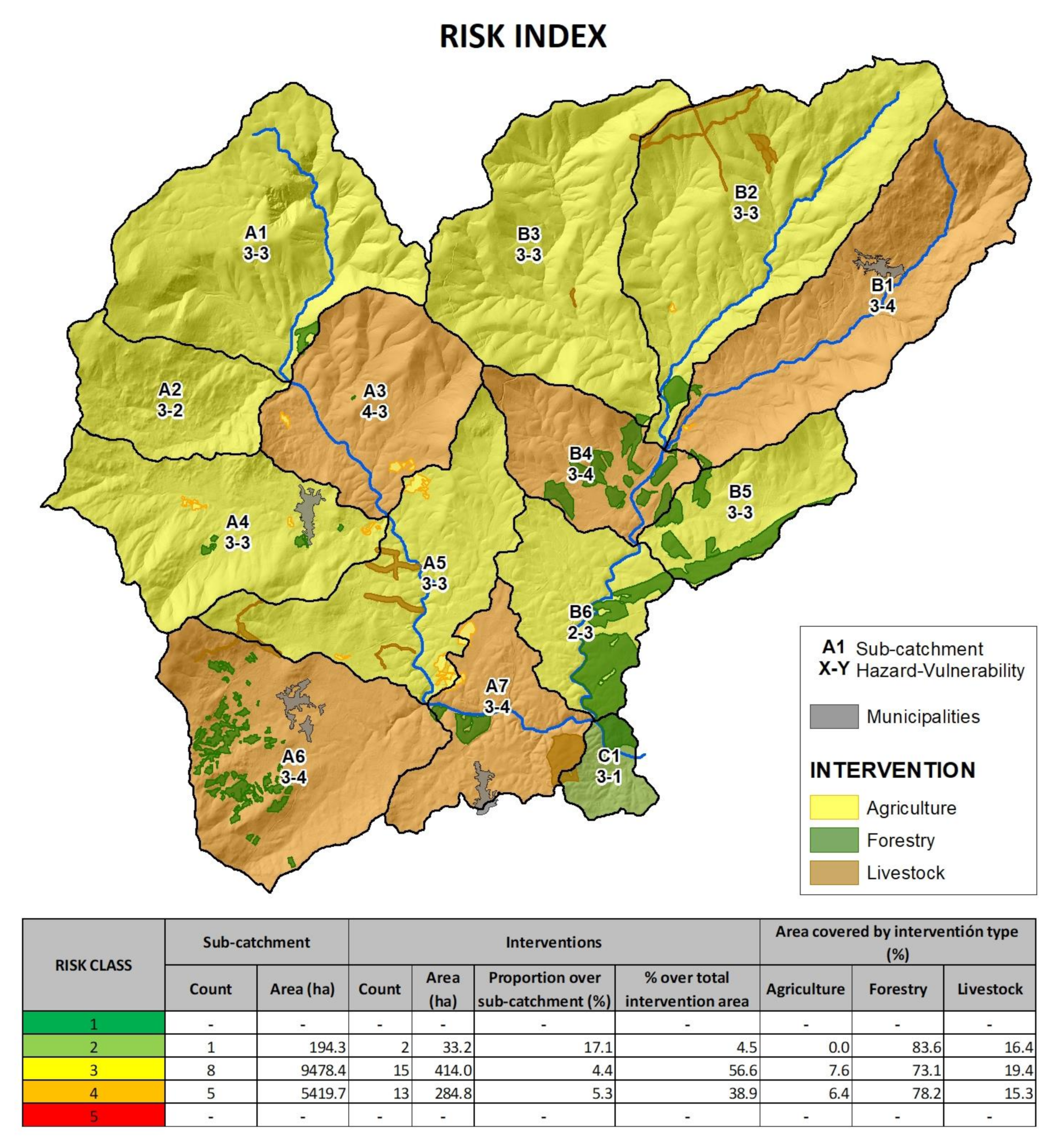
| Risk Class | Sub-Catchment | Intervention in Sub-Catchment | Area Covered by Intervention Type (%) | ||||||
|---|---|---|---|---|---|---|---|---|---|
| ID | Area (ha) | Count | Area (ha) | Proportion over Sub-Catchment (%) | Proportion over Total Intervention Area (%) | Agriculture | Forestry | Livestock | |
| 2 | C1 | 194.3 | 2 | 33.2 | 17.1 | 4.5 | 0.0 | 83.6 | 16.4 |
| 3 | A1 | 1683.1 | 1 | 9.9 | 0.6 | 1.4 | 0.0 | 100.0 | 0.0 |
| A2 | 647.9 | 0 | 0.0 | 0.0 | 0.0 | 0.0 | 0.0 | 0.0 | |
| A4 | 1201.3 | 5 | 14.5 | 1.2 | 2.0 | 46.4 | 49.1 | 4.5 | |
| A5 | 1179.3 | 9 | 58.4 | 5.0 | 8.0 | 40.5 | 0.0 | 59.5 | |
| B2 | 1873.6 | 4 | 56.4 | 3.0 | 7.7 | 1.6 | 30.7 | 67.7 | |
| B3 | 1599.5 | 3 | 9.6 | 0.6 | 1.3 | 0.0 | 31.3 | 68.7 | |
| B5 | 575.2 | 2 | 109.4 | 19.0 | 14.9 | 0.0 | 100.0 | 0.0 | |
| B6 | 718.7 | 3 | 155.8 | 21.7 | 21.3 | 0.0 | 100.0 | 0.0 | |
| 4 | A3 | 1023.0 | 5 | 7.7 | 0.8 | 1.1 | 93.7 | 6.3 | 0.0 |
| A6 | 1437.1 | 4 | 98.0 | 6.8 | 13.4 | 0.0 | 93.3 | 6.7 | |
| A7 | 739.3 | 4 | 71.2 | 9.6 | 9.7 | 14.4 | 33.5 | 52.1 | |
| B1 | 1572.3 | 2 | 8.1 | 0.5 | 1.1 | 9.9 | 90.1 | 0.0 | |
| B4 | 647.9 | 1 | 99.7 | 15.4 | 13.6 | 0.0 | 100.0 | 0.0 | |
| - | Total | 15,092.4 | 23 | 732.0 | 4.9 | 100.0 | 6.8 | 75.6 | 17.7 |
Publisher’s Note: MDPI stays neutral with regard to jurisdictional claims in published maps and institutional affiliations. |
© 2022 by the authors. Licensee MDPI, Basel, Switzerland. This article is an open access article distributed under the terms and conditions of the Creative Commons Attribution (CC BY) license (https://creativecommons.org/licenses/by/4.0/).
Share and Cite
Bertomeu, M.; Pineda, J.; Pulido, F. Managing Wildfire Risk in Mosaic Landscapes: A Case Study of the Upper Gata River Catchment in Sierra de Gata, Spain. Land 2022, 11, 465. https://doi.org/10.3390/land11040465
Bertomeu M, Pineda J, Pulido F. Managing Wildfire Risk in Mosaic Landscapes: A Case Study of the Upper Gata River Catchment in Sierra de Gata, Spain. Land. 2022; 11(4):465. https://doi.org/10.3390/land11040465
Chicago/Turabian StyleBertomeu, Manuel, Javier Pineda, and Fernando Pulido. 2022. "Managing Wildfire Risk in Mosaic Landscapes: A Case Study of the Upper Gata River Catchment in Sierra de Gata, Spain" Land 11, no. 4: 465. https://doi.org/10.3390/land11040465
APA StyleBertomeu, M., Pineda, J., & Pulido, F. (2022). Managing Wildfire Risk in Mosaic Landscapes: A Case Study of the Upper Gata River Catchment in Sierra de Gata, Spain. Land, 11(4), 465. https://doi.org/10.3390/land11040465