1. Introduction
Riverine ecosystems have been under human geoengineering influence on a large scale and for a long period of time. Freshwater systems are centers of biodiversity but also hotspots of human impacts [
1]. Anthropogenic activities are accompanied by accelerated degradation, which has led to a concomitant loss of both biodiversity and ecosystem services [
2]. The main triggers for these processes are changes in habitat (caused by land use and geoengineering measures), a non-sustainable usage of water, soil, and biomass resources, as well as changes in climate and pollution processes. The systematic changes of riverine ecosystems are related to channelization measures for navigability and an increased flow capacity, dam constructions for irrigation or electricity generation, and disconnection of channels from their floodplains in order to counteract possible flooding of these areas [
3]. On the one hand, human activities concerning fluvial engineering aim to provide services and functions, but on the other hand, they have severe negative impacts on many services provided by the fluvial ecosystems [
4]. According to Grill et al. (2015) [
5], nearly 50% of the worldwide river volume shows moderate to strong flow regulation or fragmentation problems.
In China, the rapid urbanization in recent decades and the accompanying impacts on water bodies, such as water pollution or flood control regulations, have led to a high rate of habitat destruction within fluvial ecosystems [
6]. Due to the appearance of clear signs of ecosystem degradation (e.g., extinction of red list species, massive riverbed incisions), the awareness of ecosystem functions and therefore ecosystem restoration is rising and stated within several frameworks and legislation. However, sources of data, adequate evaluation and assessment methods for fluvial ecology in general, and hydromorphology more specifically, are restricted or nonexistent. The requirements for a feasible evaluation method in a Chinese context encompass a possible widespread application at a basin scale. With regard to future restoration measures, processes and dynamics must be observed, pressures detected, and compatibility to monitoring tools given.
Many human impacts are strongly connected to hydromorphology [
6]. Physical conditions build the basis for the establishment and organization of fluvial ecosystems [
7] and therefore have a major influence on the ecological status. As the functioning of a river ecosystem is a permanent interaction of physical processes, dynamics, and biological components [
8], the understanding of impacts and generation of processes and dynamics is of high importance.
During the last decades, the geographical scale considered relevant widened from linear structures to landscape units [
7]. This awareness led to changes within the assessment and resulted in the widespread application of morphological assessment methods. Hydromorphological conditions are nowadays seen as a major part of the ecological river status [
8] and are, consequently, an essential basis for the implementation of an integrated and sustainable system for the management of water resources. The links between hydromorphology and the ecological integrity of a river system underline the necessity of hydromorphological assessment and consideration of river restoration issues. A holistic approach that seeks to reconnect water management practices with nature has the potential to deliver multiple benefits by enhancing the services and functions of river ecosystems. Successful restoration projects are essential to counteract the anthropogenic degradation of our natural environment.
All these aspects make hydromorphology a crucial river component to achieve the goals of different directives and frameworks, such as, on a global level, the UN Decade of Restoration, including land/sea degradation neutrality, and the UN Sustainable Development Goals. At the European level, besides the EU Water Framework Directive (WFD), these include a broad spectrum of frameworks and legislation tools (e.g., EU Birds and Habitats Directives, European reference framework on Nature-based Solutions (NBS), European Green Deal, EU Biodiversity Strategy for 2030 and EU Green Infrastructure (GI) Strategy). At the national Chinese level, the 13th Five Year Plan for Environment Protection, the Integrated Reform Plan for Promoting Ecological Progress, the Action Plan for Prevention and Control of Water Pollution, and China’s National Plan on the Implementation of the 2030 Agenda for Sustainable Development must be mentioned. Several instruments that should ensure the implementation of these topics were stated within the 13th Five Year Plan (e.g., Ecological Civilization Construction, River Chief System, and Lake Chief System). On the administrative level, these attempts became more prominent by the fusion of the Ministry of Ecological Environment and the Ministry of Natural Resources in 2018.
In general, the hydromorphological status consists of the following components: hydrological regime, i.e., quantity and dynamics of water flow and connection to groundwater; river continuity for sediment and biota; morphological conditions which include the variation of river depth and width, structure and substrate of the riverbed, as well as the structure of the riparian zone and the floodplain. According to this definition, hydromorphology is a multi-scale hierarchical topic [
9]. Natural river configuration is driven by the interaction of hydrological, geomorphological, and ecological processes [
10]. In addition, external factors, such as debris, vegetation, and ice blockings, have a major impact on the development of specific forms [
11]. A river’s appearance depends on the proportion of discharge, slope, and sediment availability [
12]. Therefore, idealized sequences of morphological river types can be defined. However, due to external factors, each river is expected to adjust in a different way, in different dimensions, and in different shapes [
13,
14]. The most relevant dynamics concerning fluvial geomorphology can be summarized as the water flow, sediment, bank, vegetation, large wood, and aquifer dynamics [
15]. Within the setting of the WFD, it became state of the art to measure or quantify the deviation between the current situation and a reference state. Different assessment methods approach this topic in different ways. Some show connections to historical or pristine conditions, others take the current situation into account and define reference conditions as the best attainable conditions (e.g., operational “Leitbild” [
16]). In the case of clearly defined and well-observed reference conditions, this approach shows major benefits (e.g., comparability of assessments between different catchments). The connection of assessment methods to reference conditions that aim to describe pristine or natural situations can also lead to difficulties [
17], as the reconstruction of historical situations can be difficult. Furthermore, the quantification of deviation from the pristine conditions can be challenging, as morphological processes often appear in cycles and the distinction between changes in the fluvial system as part of the natural dynamic and those being caused by anthropogenic interventions is not straightforward [
11]. Furthermore, in most cases, the historical or original situations cannot be restored. In the last years, the use of historical or pristine situations as a reference state became less frequent [
18].
As hydromorphology is a prominent part of the assessment of fluvial ecology [
8], the understanding of different fluvial processes and their interaction is vital for successful river restoration. Consequently, their assessment is a crucial step in the development of management and restoration measures [
19]. Process-based morphological assessment methods which consider fluvial corridor, active channel, and floodplains can increase the information content. These evaluation methods are focused on processes, they combine remote sensing data and field observations in an integrative way, and their results can be connected to other investigations concerning the ecosystem [
17]. Nevertheless, these methods often show some restrictions or are not developed for application in heavily modified river basins. The methodical approach is often strongly connected to the usage of GIS information, whereas field observations can provide a better understanding of local conditions at a small scale [
20]. Most of the morphological assessment methods were developed in Europe, the US, or Australia (e.g., MQI [
21], RHQ [
22], CEMs [
23], RSF [
24]). The existing approaches thus cover different geographical areas but are based on similar data sources.
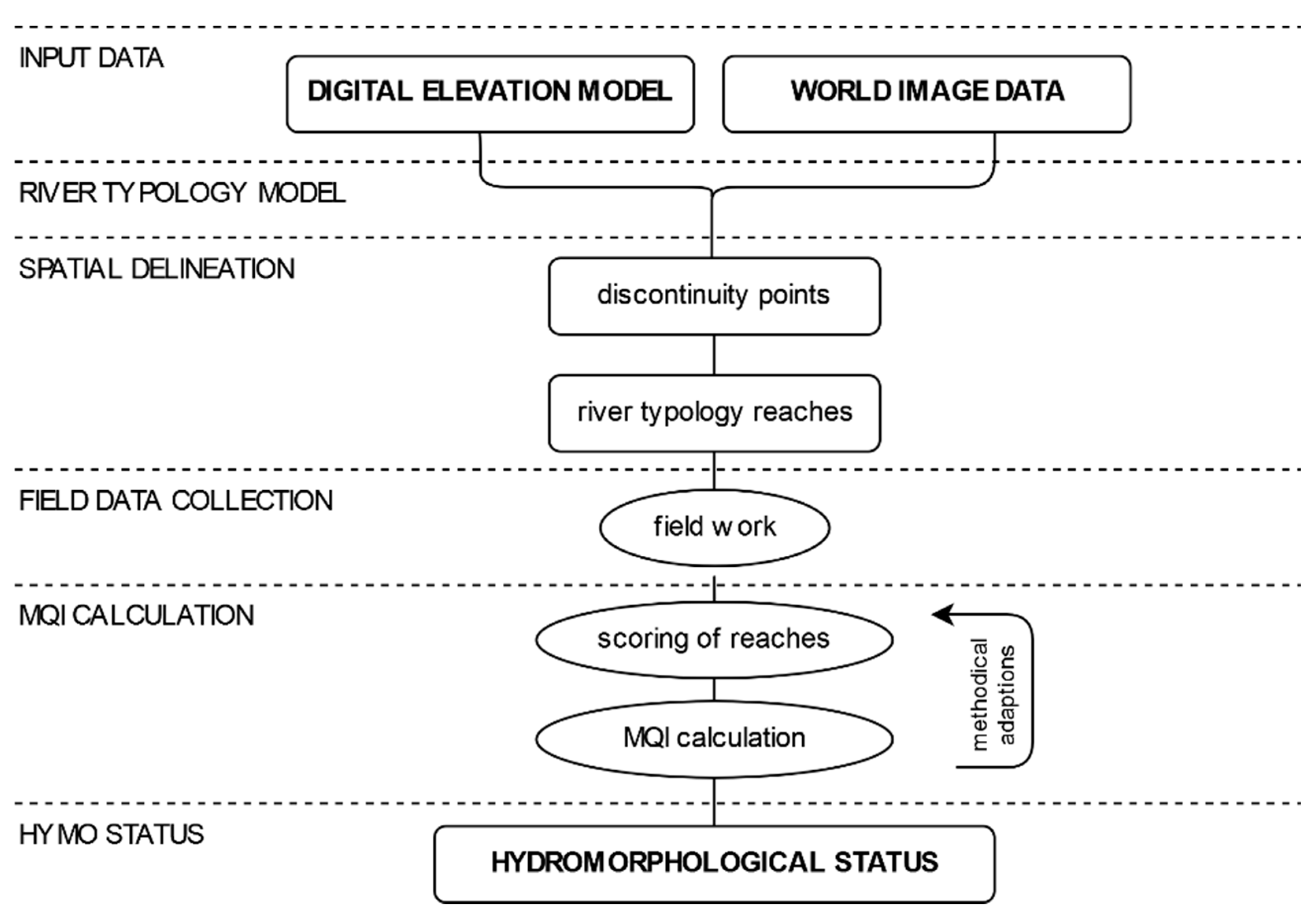
A frequently employed approach that fulfills these specifications is the Morphological Quality Index (MQI), developed by Rinaldi et al. (2012) [
21], which is based on assessing the hydromorphological situation of stream networks through pressure-response evaluation [
25]. It includes geomorphic, process-based approaches and works with indices [
26]. The assessment of functionality, artificiality, and channel adjustments can be used to infer ecological quality elements [
27]. Due to the broad methodical framework of the MQI and the objective of enabling catchment-wide assessments of the hydromorphological status, the method is considered highly relevant as a tool for process-based restoration [
27]. In particular, the MQI provides information on the current status, including critical management issues, as well as alterations and unaltered dynamics of the river system [
25]. The entire river corridor is considered, and the evaluation includes the lateral dimension of the fluvial corridor [
19]. The method was developed in Italy and later applied to a range of European river systems. Especially due to its strong emphasis on geodata, the method has the potential to be applied outside Europe in larger catchments, but the practical feasibility needs to be tested. In this paper, the application of the MQI method to a Chinese river system is presented and applicability, necessary amendments, and achievable results are discussed.
3. Results
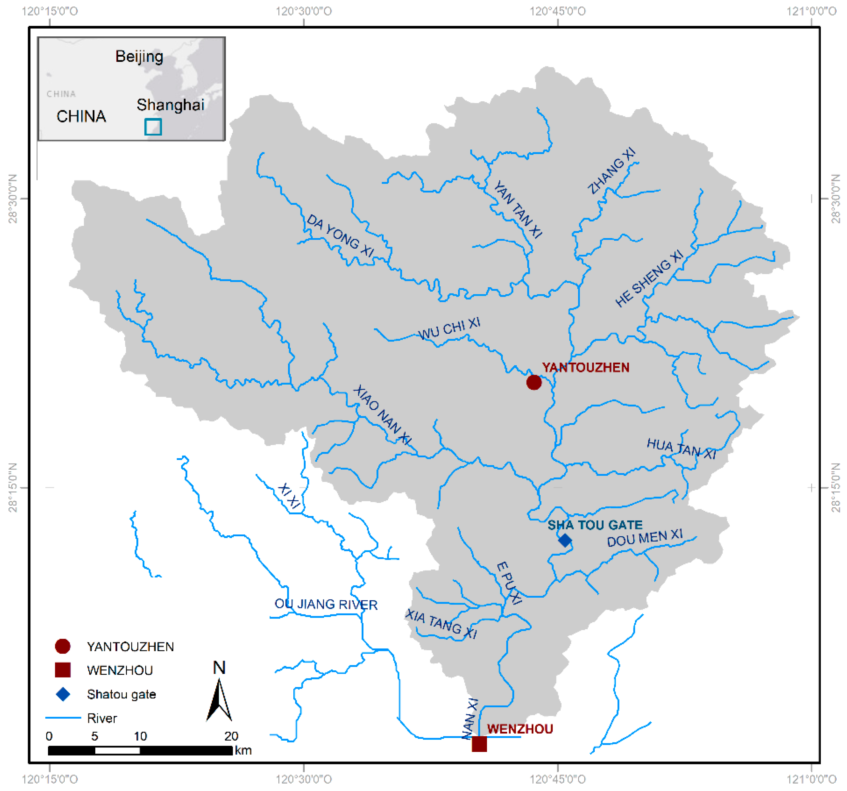
As a first step for the MQI assessment, the delineation of the reaches was an important first result (see
Figure 3). The delineation of the river network was based on 67 points of discontinuity concerning boundary conditions and led to 56 reaches. Points of discontinuity were distributed as follows: 31% tributaries > 15 km
2, 27% changes in slope, 16% dam walls, 15% multithread sections, and 11% confinement. The resulting reach length varied between 0.7 and 11.3 km, the average length amounted to 4.3 km. Reaches assigned to the Nanxi River showed an average value of 4.8 km, mainly influenced by long reaches downstream of Shatou Gate and one long river section in the upstream area. The Xiao Nan Xi River had an average reach length of 4.2 km, followed by the rivers He Sheng Xi with 3.3 km, and Yantan Xi with 2.9 km. The Zhang Xi River was not divided and consisted of one reach with 4.7 km length. Further on, 32 reaches were chosen for further analysis and the assessment; as criteria for the selection, representativity of the catchment but also heterogeneity between the reaches was considered and combined with logistical advisements.
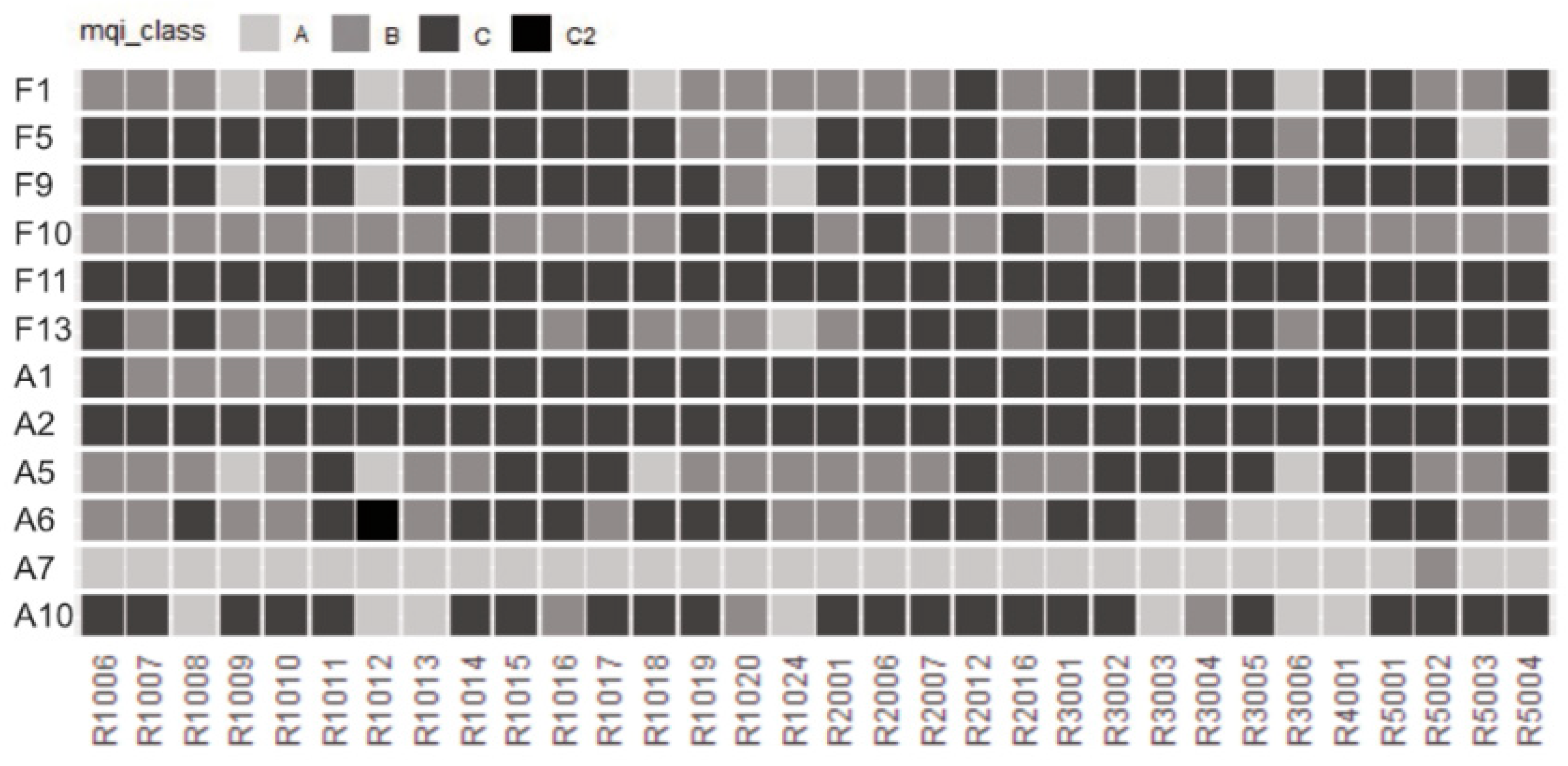
The adapted set of parameters resulted in a group of twelve indicators. Categorized into functionality, artificiality, and channel adjustment [
21], the set was equally split into functional and artificial parameters. Channel adjustments were investigated, as the necessary information was not available and not reconstructible. The parameters, their assessment units, classes, and scores are summarized in
Table 1. Changes in the wording or the exact parameter definition were carried out for all parameters with exception of Crossing structures (A5) and Presence large wood (F11). F11 was also considered part of the parameter group with adapted observation units. The evaluation unit was adapted for 50% of the parameters (F1, F11, F13, A1, A2, and A10), therefore also changes in the classification thresholds occurred. While threshold values and definitions were modified, the scoring of the classes was not adapted and refers to Rinaldi et al. (2012) [
21]. Five parameters were related to the riverbanks, seven parameters were assigned to the evaluation of the channel.
The main pressures observed (for their scoring see
Figure 4) were the dynamics of In-channel large wood (F11) and Upstream alterations of sediment discharge (A2), which were found to be in a totally disturbed situation over the whole river basin. Concerning alterations, Upstream alteration of flow (A1) and restrictions in lateral continuum caused by Bank protection (A6) showed bad performances. Alterations in terms of Sediment manipulation (A10) were present on more than 15% of the whole river system. The assessment of the Functional parameters presence of large wood (F11) and Presence of erodible corridors (F5) revealed a deficit over all river sections. The presence of Linear functional vegetation (F13) was equally strongly restricted. Cross-section variability (F9) appeared more homogenous than heterogeneous.
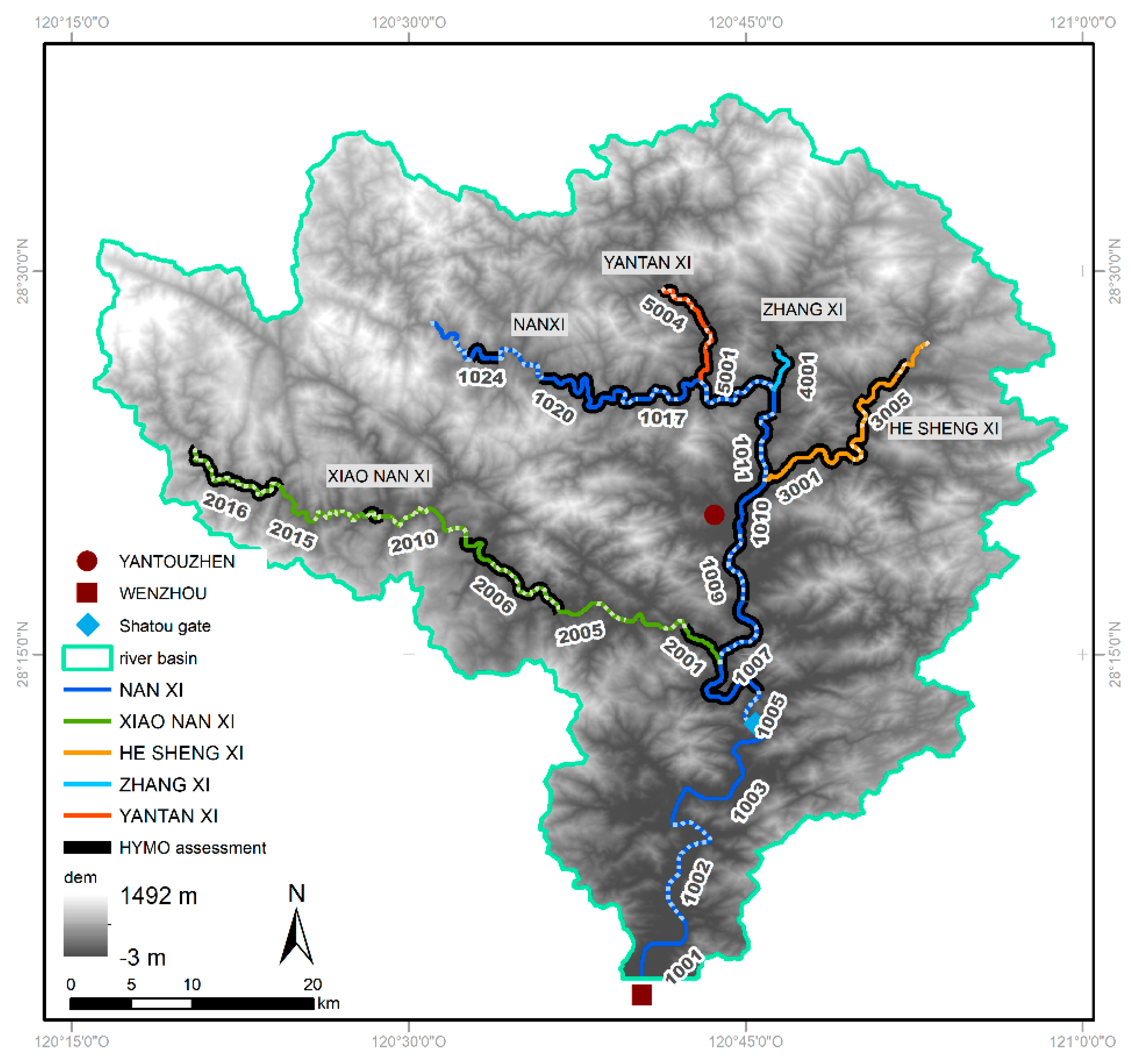
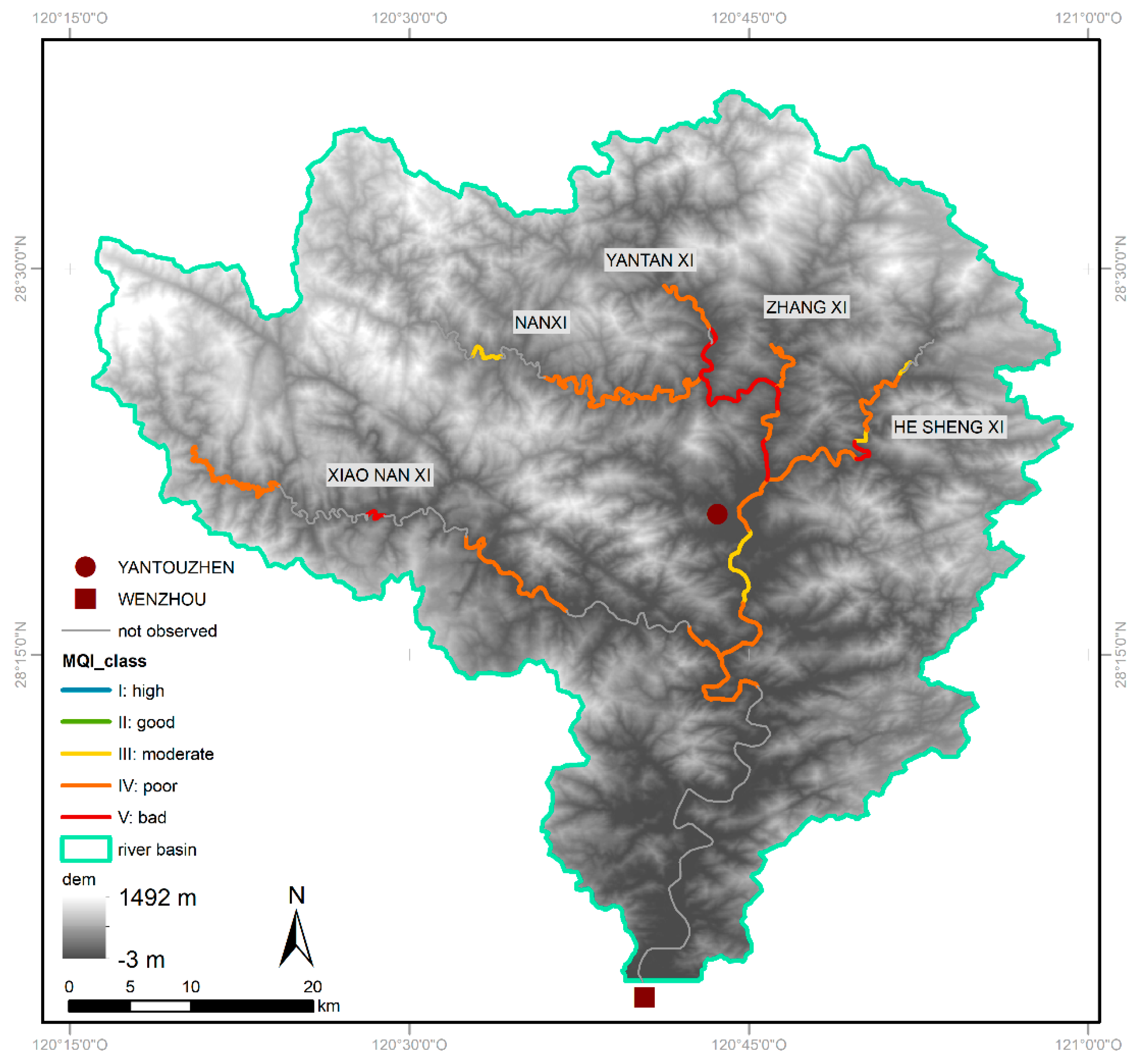
The hydromorphological status of the Nanxi river system was evaluated over 32 reaches with a total length of 161.4 km (see
Figure 5). Fifty percent of the observed length was along the Nanxi River, 22% along the Xiao Nan Xi River, and 16% along the He Sheng Xi River. The assessed length of the Zhang Xi and Yantan Xi Rivers covered 4% and 8% of the total river kilometers investigated. The MQI values covered a range of 0.26 to 0.61, which describes moderate to bad conditions, the average across all reaches was 0.37, representing a poor status. In total, 8% of the observed river system were in a moderate state, 75% in poor, and 17% in bad status. Reaches that represented a good or high hydromorphological status could not be detected in the Nanxi river system (see
Figure 5). Except for the Zhang Xi, all rivers showed stretches in a bad hydromorphological state. While this concerned only one short section each in the Xiao Nan Xi and He Sheng Xi Rivers, the Yantan Xi River displayed a bad status over 48% of the analyzed length.
Analyses of the correlation between normalized single parameters and the final MQI assessment of the reaches resulted in negative values, as the MQI decreased with rising scoring of the parameters. For Sediment manipulation (A10) and Variability of the cross-section (F9), the highest correlations to the MQI were detected. With a closer look, F9 and A10 showed similar behavior. All reaches with an overall assessment of a bad hydromorphological status were classified with class C. Moreover, regarding the four moderate reaches, three of them were classified as A. In terms of correlation, F9 and A10 were followed by Crossing structures (A5), Linear extension of functional vegetation (F13), and Longitudinal continuity in sediment and wood flux (F1). The weakest correlation existed between the Structure of the channel bed (F10) and the final MQI value. This parameter did not show a lot of variation between the reaches: six reaches were given class C, all others class B. For the parameter Presence of large wood (F11) and Upstream alteration of sediment discharge (A2), no correlations could be identified, as these parameters scored equally for all reaches.
4. Discussion
Hydromorphological dynamics have a major impact on the physical status as well as on the biota of fluvial ecosystems and the interaction of both. The MQI method effectively provides a guideline for the process-based evaluation and assessment of the hydromorphological conditions [
25]. It is a recognized method (e.g., [
17,
27]) and provides a good basis for restoration and river management planning by the identification of pressures, alterations, and functionalities. The focus on reach scale enables catchment-wide evaluation. The method has been tested, evaluated, and improved within Europe and Canada (e.g., [
19,
26,
27,
33,
34]).
The catchment-wide application of the MQI within a setting located outside of Europe required adaptions, interventions in both the method and the definitions, and led to reductions and simplifications in the set of parameters. A full application of the method from Rinaldi et al. (2012) [
21] was not possible due to limitations in data availability, which mainly concerned hydrological data and information on the natural appearance of the river system. The result was the assessment of the Nanxi River in a simplified way but following the concept of the MQI. The approach detected occurring processes and pressures and led to an internal differentiation of hydromorphological quality within the river basin. Based on the identification of pressures, the internal ranking was supplemented by a general hydromorphological status. Longitudinal field surveys were conducted to enlarge the data basis. The results of the MQI calculation reflected an expert assessment of the conditions within the river system during the fieldwork. This study represents one of the first attempts of a basin-wide hydromorphological evaluation in this region. In the given context, the assessment approach was not state-of-the-art; in general, statements concerning hydromorphological conditions at a basin-scale as the basis for river management and restoration planning do not exist. Nevertheless, hydromorphology represents, among others (e.g., biota, water quality), only one aspect of developing riverine restoration concepts. In addition to physical, biological, and ecological aspects, social, cultural, and economic issues of the local population must be considered for the successful implementation of management actions or restoration measures. Multidisciplinary approaches are required. Ecological and socioeconomic aspects are in direct interaction, disregarding this aspect in restoration measures can lead to failure [
35].
In order to apply the approach of this study to other river basins, the impacts of processes, chosen parameter set, and threshold values need to be evaluated carefully, supplemented, and analyzed via sensitivity analyses to reflect further hydromorphological process chains. Additional parameters concerning the integration of vegetation and channel should be introduced.
As described above, there are methods that incorporate the reference state as a central basis for assessment and others that are not based on it. The use of historical data to define a reference condition is discussed in the scientific community, and there are various approaches in which the use of historical data as a reference condition ranges between being an integral part of the assessment to its complete neglect. For example, the HYMET tool focuses on the observation of morphological quality based on alterations in sediment availability and transport, without considering reference conditions [
36]. The RHQ method determines the hydromorphological status by assessing ten criteria concerning cross-section and channel attributes, referring to the best attainable status under the given environment without human impacts [
20]. While Jungwirth et al. (2002) [
16] combined these aspects in the introduction for a “visionary Leitbild”, which reflects the natural specific situation, and the “operational Leitbild”, in which the current environmental circumstances (e.g., land-use changes, etc.) are considered. By restoration measures, it is mostly not possible to restore the former situation [
37]. Since river stretches in the Nanxi catchment are highly modified, the assessment of the hydromorphological quality in this study was conducted without referring to a specific historical or pristine status and temporal components were neglected. Morphological features were observed in order to detect artificiality and pressures. The absence of obvious human impacts was attributed as a high-quality criterion. Alterations and pressures were assessed according to the defined set of parameters. The degree of observed alteration was displayed in the ranking and scoring of each parameter. The aim was to create an internal differentiation of pressures and quality components in order to clarify the overall hydromorphological situation. A stringent assessment of the deviation from the historical condition would have led to a result that reflects the heavy modifications and which leads to large parts of the river system being classified in a poor condition. Regarding the aim of developing future restoration plans, creating an internal differentiation of quality is essential.
The data basis for the assessment of each parameter can be from different sources. Either GIS information can be used, or the information is gained through extensive field observations, which can be seen as a disadvantage (e.g., time-consuming) but also bring some benefits. Hajdukiewicz et al. (2017) [
20] stated the importance of field data concerning the planning of restoration measures, due to their level of detail. The observations deliver more sophisticated information than low-resolution GIS data. If geodata is not available and the usage of UAV is not feasible, GIS-based assessment methods can be applied by the integration of field data. Compared to Rinaldi et al. (2017) [
25] and other hydromorphological assessment methods that work remotely and check plausibility at the site, the main focus in the presented approach was on continuous longitudinal field observations.
The set of parameters was optimized in order to display the major hydromorphological processes and to create a feasible and practicable extent of fieldwork. Major advantages of this approach are the creation of additional knowledge about the river basin and a permanent plausibility check of the calculated status based on the impressions gained through field observations. Furthermore, the presented approach can easily be transferred to other river basins, as the used world image data and satellite DEMs, which were the main input data, are available worldwide in sufficient resolution.
The adapted set of parameters represents functions and pressures, dynamics and processes, as well as external factors, such as hydrological regime and discharge alteration, sediment manipulation, and vegetation cover. Alterations and pressures accumulate along the river system and can cause severe impacts on downstream reaches [
36]. Failures in the functionality of restoration measures at the reach scale are observed frequently due to a disregard for catchment-wide alterations and pressures [
37]. In order to consider these aspects in the assessment of a given hydromorphological status, quality elements and pressures were mainly observed at the reach scale. Additionally, some parameters concerning the catchment scale were introduced. The assessment criteria for standardized structural evaluation according to EN 14614 [
38,
39], were mainly reflected within the adapted set of parameters, only macrophytes and in-channel vegetation were not taken into account. All surveyed parameters could be assigned to the main hydromorphological dynamics defined by Garcia de Jalón et al. (2013) [
15], with several parameters functioning as indicators for two or more processes.
Concerning processes and dynamics, vegetation is an important factor in river dynamics and ecology, as it is in permanent interaction with hydromorphological processes in the river and its floodplains [
40]. In the set of parameters only the longitudinal extension of functional vegetation bordering the active channel was taken into account, this covered aspects such as shading, deposits of organic material, and wood dynamics. For the representation of connectivity between river corridor and alluvial plains and the function of riverine ecosystems, the width of riverine forests should be considered in a hydromorphological assessment. However, due to the sub-tropical climate, the riparian width was difficult to register since typical mountain vegetation was very close to the riverbed. Lateral and longitudinal connectivity was represented in this study in a broad spectrum of parameters (e.g., presence of bank protection, presence of erodible corridor, longitudinal continuity in sediment and wood flux). While the third (vertical) dimension of the continuum, which represents the surface water–groundwater interaction [
41], was considered in only one parameter, which was the survey of armoring or clogging (Structure of the channel bed (F10)).
The spatial delineation of reaches was done on the basis of confinement, slope, river threads, tributaries, and dam walls. Referring to Rinaldi et al. (2015) [
30], confinement, threads, and river planform are parts of “Basic River Typology”, while slope is, among others, assigned to the “Extended River Typology”. Dam walls and bigger tributaries were additionally taken into account as discontinuity points due to their impact on hydrology and the longitudinal continuity of reaches, leading to massive changes in boundary conditions (e.g., lake-like conditions upstream vs. residual flow downstream; big tributaries inundating into a river stretch affected by residual flow). Concerning river planform, the important role of planform patterns as attributes and boundary conditions of fluvial systems has to be stated. Even so, due to restrictions in available geodata, a detailed evaluation for the Nanxi River was not possible. Only breaks between single and multithread sections were considered as points of discontinuity. As the impacts of modifications and dams are high, changes in river planform were assumed to be of minor importance for changes in boundary conditions in the Nanxi river basin, which once further highlights the degree of human pressures and alterations. The resulting reach length varied between 0.7 and 11.3 km, slightly exceeding the length of 10.0 km supposed by Rinaldi et al. (2015) [
30]. Severe impacts on the application of the method could be rejected, as, due to artificiality and impacts in the Nanxi river basin, similar conditions appeared over longer river segments. The results of the calculated MQI appeared plausible, as they reflected observed main attributes of the river basin, where upstream dams together with a large number of smaller transverse structures impeded any longitudinal continuity. In general, no fish passes are existent (with exception of Shatou Gate) and the connectivity of woody debris and sediment flux was also heavily restricted. The sediment dynamics were additionally disturbed by massive manipulations, including excavation and deposition, which are no longer permitted but still occur. This aspect is intensified by changes in the flow caused by residual flow and strong impacts of hydropeaking. The riverbed was widely armored, and due to lake-like conditions upstream, suspended solids were retained in the transverse structures and flushed out in hydropeaking situations, resulting in clogged hyporheic zones. Therefore, upstream alteration of sediment discharge and flow was assigned the status “heavy alteration of sediment discharge: serious signs of sediment deficits are present” and “heavy alteration of flow conditions: influence of hydropeaking, water retention, residual flow, etc.” over large parts. The sediment deficit leads to riverbed incision and becomes widely visible through the undermining of bridges. Lateral connectivity was included in the assessment by observing a potentially erodible corridor, bank protections, and levees. While the presence of bank protections and the absence of an erodible corridor indicated major alterations, the widespread absence of levees can be considered positive, although this has relatively little impact due to the frequent bank protections. In upstream parts, bank protections are connected to depositions of debris from former construction sites, in downstream areas banks are often paved. Armoring and clogging were detected in various parts over all reaches. In the upstream area of the Nanxi River, where hydropeaking effects cannot be buffered due to the geographical proximity to the source of impact, main parts of the river were affected.
5. Conclusions
In order to provide a database for restoration planning or other river management activities, it is a necessity to conduct hydromorphological surveys, particularly for heavily altered river systems, independent of data sources or geographical settings. In this study, the well-recognized European MQI method was applied and adapted in a highly modified river system in China.
Although it was a limited application of the MQI method, the adaptations and modifications resulted in a plausible assessment of the hydromorphological status quo in the Nanxi river basin. The results function as an internal differentiation concerning quality elements and pressures of the river system. The pressures were identified and can function as a basis for future restoration planning.
Choosing the MQI method under the given circumstances included a certain risk of failure. Due to the broad approach of the MQI, adjustments and changes of the methodology were possible, and an assessment procedure adapted to the local conditions could be developed. Adapting the MQI method had significant advantages, as the adjusted approach used only a small amount of input data and did not require specific equipment. The application and testing of other methods are recommended, as the comparison of results and feasibility may lead to knowledge enrichment. A synthesis of different approaches resulting in a specific Chinese hydromorphological assessment method is conceivable. The MQI proved to be a suitable basis for the development of non-European hydromorphological assessment methods. Especially in highly impacted river basins, such as the Nanxi River, where restoration measures are necessary, the monitoring function should be given high priority.
Our results support the use of MQI, and the parameter set to identify the most stressing pressures acting upon the Nanxi river basin and suggest that restoration planning should include measures targeted at improving river continuity (either due to small or large dams or due to crossing structures that reduce river space) and establish natural river vegetation. The high number of small hydropower plants in the system and the fact that these are obsolete in some cases calls for a detailed assessment of these structures and the development of a conversion plan to improve river hydromorphology and freshwater ecosystems. Implementation of ecological flows and fish passes in the cases where dams are unavoidable is also mandatory if restoration goals are to be achieved. Sediment excavation and deposition are no longer permitted in Nanxi (according to Yongjia County Government (2016) [
42]) though it must be considered that stronger surveillance and governance mechanisms could contribute to change local behaviors of direct collection of riverbed sediments. The River Chief system may play an important role in detecting illegal sediment manipulation.
The prevailing hydromorphological conditions in the Nanxi river basin strongly require restoration measures and changes in river management to counteract the effects of present degradation and habitat loss. Moreover, there is an obligation to act referring to reach the goals set in the 13th Five Year Plan for Environment Protection, Chinese and international legislation, and other frameworks.


 ,
, 


