Article

Land-Use Changes on Ob River Floodplain (Western Siberia, Russia) in Context of Natural and Social Changes over Past 200 Years

1
Laboratory of Sedimentology and Paleobiosphere Evolution, University of Tyumen, 625003 Tyumen, Russia
2
BIO-GEO-CLIM Laboratory, National Research Tomsk State University, Lenina 36, 634050 Tomsk, Russia
*
Author to whom correspondence should be addressed.
Land 2022, 11(12), 2258; https://doi.org/10.3390/land11122258
Submission received: 7 November 2022 / Revised: 2 December 2022 / Accepted: 8 December 2022 / Published: 10 December 2022

Abstract

:
Over the past century, substantial changes in land use have taken place in the boreal zone of northern Eurasia. The consequences of these large-scale changes for the ecosystems of Europe have been well studied; however, they have not been addressed for the large expanses of Russia. We conducted a retrospective analysis of the landscape dynamics of the middle reaches of the Ob floodplain (Western Siberia) using multitemporal maps of the vegetation cover and land use for five time points (1830, 1910, 1950, 1976, and 2019). By the 1830s, all the land that was suitable for haymaking and plowing (rarely flooded and not swamped) had been put to agricultural use. The meadows of the Ob floodplain are human-controlled and were mainly formed before the 1830s. From the 1830s to the 1990s, the meadows were used in agriculture and their areas increased. The maximum development of the floodplain occurred in the 1970s and 1980s, when previous wetlands were put into operation through the construction of drainage systems. A massive abandonment of pastures and reclaimed land occurred in the late 20th century. According to the data over the last 30 years, abandoned meadows are resistant to overgrowth with trees and shrubs. The spatial configurations of the floodplain landscapes have also been quite stable. The main spatial changes are confined to the near-channel floodplain, with the formation of new near-channel shallows. The floodplain landscapes of the Ob River demonstrate substantial spatial and temporal stabilities, and long-standing agricultural development.

1. Introduction

The new research material that has accumulated on historical ecology provides increasing evidence that many originally pristine landscapes have experienced the direct or wildfire-mediated impact of human societies [1,2,3,4,5,6,7]. Even if we eliminate the anthropogenic pressure on landscapes, the subsequent postanthropogenic succession of vegetation and soils still depends on the nature of the prior land use. Considering the widespread human activity, and especially in the older developed regions of the world, we can only explain the landscape patterns based on the spatial land-use patterns associated with the historical stages of the society’s development [8,9]. Understanding the contribution of the antecedent land uses to the appearance and structure of the current spontaneously evolving ecosystems helps with the selection of environmental protection strategies and the evaluation of ecosystem services [10,11]. Understanding the history and causes of the ongoing succession is essential for predicting the future state of ecosystems and maintaining the high biodiversity and ecological value of landscapes [12,13].
Recent centuries in the boreal belt of Europe and Asia have seen massive changes in the environment that are, to a large extent, associated with the complete abandonment of traditional agricultural practices, and particularly the system of slash-and-burn farming [14,15]. In northern Eurasia, the most widespread change in land use in the 20th century occurred in Russia [16]. Nearly 650,000 km2 of agricultural land was abandoned over the century [17]. The area of arable land was most actively reduced after 1990 and, between 1990 and 2009, 272,000 km2 was abandoned in the European part of Russia [18]. The reasons for the “abandonment” of the land by the people lies in the socioeconomic processes [19] that took place in Russia in the 20th century (civil war, peasant reforms, revolutions, accelerated urbanization, and state restructuring (perestroika) in the late 1980s), which caused intense rural depopulation [20,21]. In addition, large-scale melioration activities were performed in the southern part of the forest zone during the era of the Soviet Union [22,23], and many meliorated lands were abandoned after the state restructuring. As a result, a wide range of postagrogenic ecosystems are now developing in large areas of the southern forest zone [24,25,26,27,28]. Former agricultural lands that are now overgrown with forests play an important role as carbon sinks [29,30,31]. The effects of climate change and land use on the carbon balance are comparable [32], which makes regional retrospective studies of the landscapes relevant for our understanding of the extent of the imbalance caused by the previous land use.
Understanding the human contribution to the formation of modern landscape patterns requires a thorough analysis of historical cartographic materials, archival statistical materials, and remote sensing data. For the older developed regions of Russia, this approach allows for an in-depth retrospective analysis over a period of up to 150–250 years [33,34].
Researchers have studied the historical dynamics of Russian landscapes in terms of time slices for many landscapes of the European territory of Russia and the Urals [35,36,37,38]. They have established a substantial change in the structure of the land use in recent centuries, as well as the leading role of anthropogenic factors in the formation of the landscape patterns. Researchers have performed a few similar works for the territory of Siberia; however, they are both geographically limited to the grain belt of Western Siberia and temporally limited to recent decades [39,40]. Some authors argue that the human contribution to the formation of the forest landscapes in Siberia is insubstantial. However, there is growing evidence from both archaeologists and historians that the south of the forest zone has been substantially transformed over the past four centuries, at least by peasants [41]. There is also emerging evidence that farming in the south of the forest zone occurred before these territories became part of Russia [42,43]. Researchers have also established the substantial human impact on the dynamics of the fires in the taiga during the second half of the Holocene [44].
The impact of the land-use change on the soil organic carbon stocks is as important as the impact of climate change [45,46]. The state of the abandoned land in Siberia, as well as its successional pathways, are almost unstudied. The afforestation of the abandoned croplands and pastures in Western Siberia is often complicated by the waterlogging processes and dynamics of the river systems. The second largest floodplain in the world is located in Western Siberia, and it belongs to the Ob River [47]. The dynamics of the Ob floodplain landscapes depend on the socioeconomic conditions of agricultural activities, and it is strongly affected by floods and channel processes. The Ob hydroelectric power plant and Novosibirsk reservoir, built in the 1950s, are also of great importance for the middle reaches of the Ob [48] because they make the floodplain flooding less extensive. The practice of river ice blasting is employed to prevent the formation of the blockages that previously led to severe floodplain inundations [49,50]. Despite the enormous size and high dynamics of the landscapes, we lack studies on the land dynamics of the Ob River floodplain. Conversely, the landscape dynamics of the world’s largest river floodplain, the Amazon, has been the subject of numerous works [51,52,53,54,55,56].
In this work, our purpose was to study the changes in the land use of the floodplain of the middle reaches of the Ob River. We chose the floodplain near the Kaibasovo Research Station of Tomsk State University (south of the forest zone of Western Siberia) as the key site. Because the selected territory is one of the older developed ones, we conducted an analysis of the dynamics of nature management in the area over a period of 200 years. Our study can be used to determine the direction of the landscape succession. Changes in the peasant use of meadows may threaten some species [57]. The dynamics of the riverbed and its channels also affect the dynamics of floodplain landscapes [58] and, hence, the numbers of species, which require monitoring for the purpose of forecasting.

2. Materials and Methods

2.1. Study Area and Landscape Settings

The object of the study was the middle course of the Ob floodplain within the Krivosheinsky District of the Tomsk region (Russia) (Figure 1). The width of the Ob floodplain in this area varies from 17 to 21 km. The slopes of the Ob River valley consist of terraces of the Quaternary age that form tiered structures. The terraces are composed of sands and dusty loams, which are the basis for the formation of the floodplain deposits [59]. The greatest height of the floodplain above the low-water edge of the Ob River is 8–10 m [60,61]. According to the flooding conditions, we can divide the floodplain into the near-river, central, and near-terrasse floodplains. The near-river floodplain is the most frequently flooded, and it is characterized by the active rapid deposition of silt, the formation of near-riverbank ramparts, and the destruction of the banks. The central floodplain is located far from the main channel of the Ob, and it consists of elongated ridges and waterlogged depressions. The floodplain is actively used in agriculture as hayfields and pastures. On the near-terrasse floodplain, which adjoins unflooded terraces, groundwater is discharged [62]; as a result, it is almost entirely occupied by peat bogs, with a peat deposition thickness from 0.2 to 5 m [63]. In the period from 1970 to 1980, drainage works were carried out on the central floodplain and partially on the near-terrasse floodplain, which allowed for their transformations into agricultural use. However, most of the lands that developed due to melioration have currently been abandoned and are now under the category of fallow lands.
Grasslands occupy a vast area of the open floodplain landscape. The specific feature of floodplain grasslands is their severe waterlogging, which, combined with the harsh climatic conditions, makes it difficult to use them for agriculture. The Ob floodplain grasslands are highly productive and species-rich lands that have long been used as pastures and hayfields, providing fodder resources for most of the region [64].
The total study area is 180 km2. This section of the floodplain is located on the northern periphery of the agricultural belt of the southeastern part of the West Siberian Plain. To the north of this area, the area of floodplain grasslands sharply decreases due to the large proportion of swamps and peat bogs. In previous centuries, this part of the floodplain was largely involved in the economic activities of the population. The least populated waterlogged areas were affected by drainage melioration. For this reason, we chose this section of the floodplain, as well as the surrounding landscapes of the terrace above it, to study the dynamics of the landscapes over the past 200 years.

2.2. Cartographic Sources and Remote Sensing Data

We used two types of spatial data: archival cartographic materials and remote sensing data from the second half of the 20th century.
The oldest source is a topographic map from the 1820s–1830s at a scale from 1 cm to 2 km, which was recently found in the Russian State Military Historical Archive (Moscow) (Figure A1). For the first time, we used this old map to analyze the landscape dynamics of Western Siberia. This source was the least informative and it contains substantial spatial distortions, although we could georeference it in general terms. This map lacks a legend with symbols, and so we employed the legends available for the neighboring regions. On the map, the natural and hay grasslands are not indicated, and the arable land is not isolated. The map represents forests with the predominant tree species, woodless areas, swamp and peat bogs, bushes, water bodies, settlements, and roads. For part of the study area, we used the 1911 geometric plan of the village of Kaibasovo from the Museum of Regional Studies, the Tomsk region. The scale of the plan is from 1 English inch to 200 fathoms (Figure A2), and it includes a legend that allowed us to be more certain about the land types. In general, the information is similar to that provided on the previous map.
We collected the data on the structures of the landscapes from an early 1950s topographic map with a scale from 1 cm to 1 km. The map is relatively modern, indicating grasslands, forests, marshes, roads, and water bodies. The map was drawn according to the Pulkovo coordinate system of 1942 (SK-42), and georeferencing was continued by converting the coordinates to the WGS-84 system, which contains the remote sensing data used in this paper.
Two CORONA satellite images (14 August 1973 and 17 June 1975) were the earliest available remote sensing data obtained for the study area. The spatial resolution of the images is 2 m. The 1975 image, acquired in late June, enables the estimation of the area of arable lands (because it was not yet covered with crops), and the 1973 image, acquired during the low-water period, allowed us to recognize the riverbed processes and status of the reclamation system. We obtained the modern Sentinel-2 space images, with a spatial resolution of 10 m, from the Sentinel Hub source (EO Browser). To create a sample for the training classifier, we used combinations of the basic (red, green, blue) channels, as well as near and shortwave infrared channels. We used the detailed imagery available on the ESRI’s imagery metadata webpage to refine the boundaries and configurations of the landscapes. The Sentinel-2 space images allowed us to diagnose the fallow grasslands. Because the fallow lands are mainly former hayfields, we additionally used multitemporal Sentinel images for different summer seasons to separate the uncut or short-term unused hayfields, as well as the pastures in the western part of the image, from the long-term fallow lands. Another diagnostic sign of the nonuse of swaths is the distribution of the shrubs. We used detailed open-access images in Google Earth Pro to detect the shrubs.
The cartographic materials represented three layers of information, and the remote sensing data represented two layers. We obtained all of these materials at different times using different methods, which made it difficult to compare them. The small size of the individual floodplain microlandscapes also created difficulties due to the complex microtopographies. Therefore, we chose the most generalized landscape categories for the comparison of the landscape dynamics to compare the following sources of information: water bodies; swamps; roads and residential areas (settlement land); forested swamps; sandy deposits; upland forests; floodplain forests; dry grassland and arable land; and grasslands and fallow grasslands, including brushwood. We conducted field trip observations, including drone surveys, for a more reliable interpretation.
To determine the temporal changes in the population sizes, we used archival materials, including lists of the settlements in the Tomsk region (1859, 1897, 1893, 1911, 1913, 1923, 1926) and modern census data, which we used to estimate the population dynamics (URL: https://rosstat.gov.ru (accessed on 2 April 2022)).

2.3. Geoinformation Approaches to Analysis of Historical Maps and Remote Sensing Data

We preprocessed the historical images by georeferencing to obtain the information contained on the maps. We performed the georeferencing of the raster historical maps using the ground control point method. We primarily used road crossings and river confluences as the points because they have substantially changed over time [65]. We georeferenced the topographic maps using a coordinate grid. Then, we manually digitized the maps into shapefiles. The choice of the manual digitization method was due to the quality of the archive maps, which was not adequate for high-precision automatic digitization. We also manually digitized the geometric plan of the village of Kaibasovo because of the large number of map labels.
To digitize the satellite images, we used automatic interpretation methods: supervised maximum likelihood classification and unsupervised ISODATA classification. We applied manual corrections during the postdigitization using the ArcMap application of ArcGIS 10.4 for Desktop software by ESRI Inc. [66]. The maximum likelihood classification method is one of the first and is the most popular supervised classification method for land-cover mapping [67]. The method performs better with sufficient training samples and normally distributed image values. It assigns pixels to the classes based on the mean values and variance indices of the class signatures. During the classification, all the unclassified pixels are assigned memberships based on the relative likelihood of their occurrence within each category’s probability density function [68].
A relatively small part of the study area allowed us to combine automatic and visual interpretation methods applying semiautomatic classification and, after that, the manual correction of the classification errors. This approach ensured the minimum time consumption and more accurate results compared with those that would have been obtained by using any of the methods separately. As a result, we could determine the number of classes and their values for each image. We could not make single classifications because the 1830s map contains no sand deposits, roads, or exact settlement boundaries, and the images of the CORONA are black and white, with difficult-to-recognize open swamps.
We encountered serious difficulties when separating the fallow grassland and floodplain grassland classes because they have similar spectral characteristics and vegetation-cover features. We manually separated the tall floodplain shrub and wet forest classes from the floodplain forest class for the same reason. The mapping of the water bodies and sand deposits was the most accurate because of the distinguishing spectral brightnesses of these classes.
We created the training samples for each class by a careful overview of the satellite images. To increase the validity of the Sentinel image classification, we used open-access high-resolution images. We created a total of 80–90 training samples to train the images.
The postprocessing of the classified images included reducing the random noise from the misclassified pixels and improving the images [69]. We evaluated the accuracy of the classified image to determine the quality of the output data and identify errors. We assessed the output data accuracy by creating sets of randomly located points from the classified images and manually identifying each point based on the ground control data. We also visually determined them using the high-resolution satellite images. Then, we compared the values of the points containing the true data to the classified data using a confusion matrix. For each classified satellite image, we created 500 points. For each landscape class, from 9–10 to 150 observations were randomly generated, depending on the class area. We obtained the confusion matrix, and we calculated the overall accuracy and kappa coefficient.
The overall accuracy of the CORONA classified data was 89.9%, with a kappa coefficient of 87.1%, and the Sentinel classification accuracy was 88.8%, with a kappa coefficient of 86.7%, which corresponded to the standard accuracy of 85–90% for landscape mapping [70].

3. Results

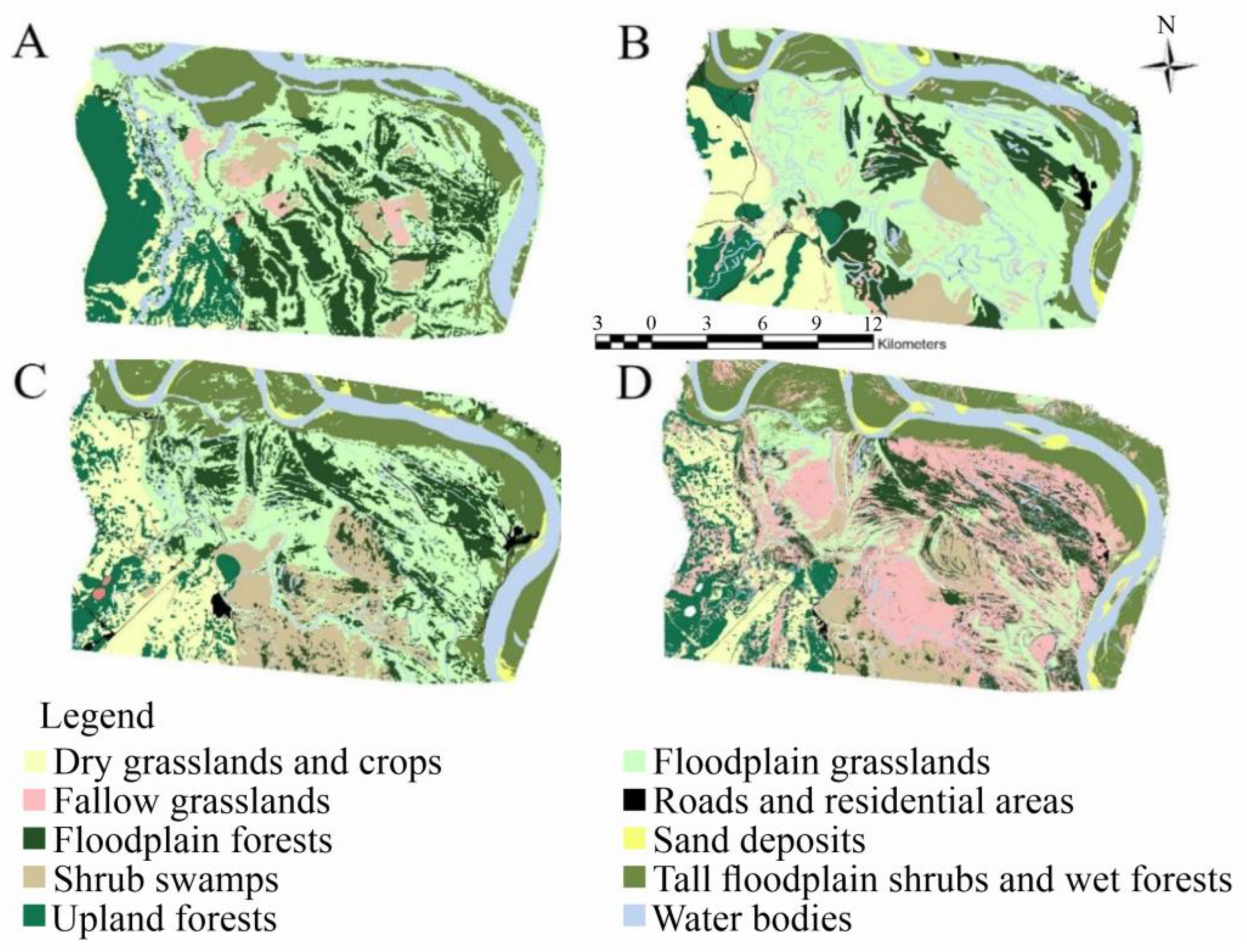
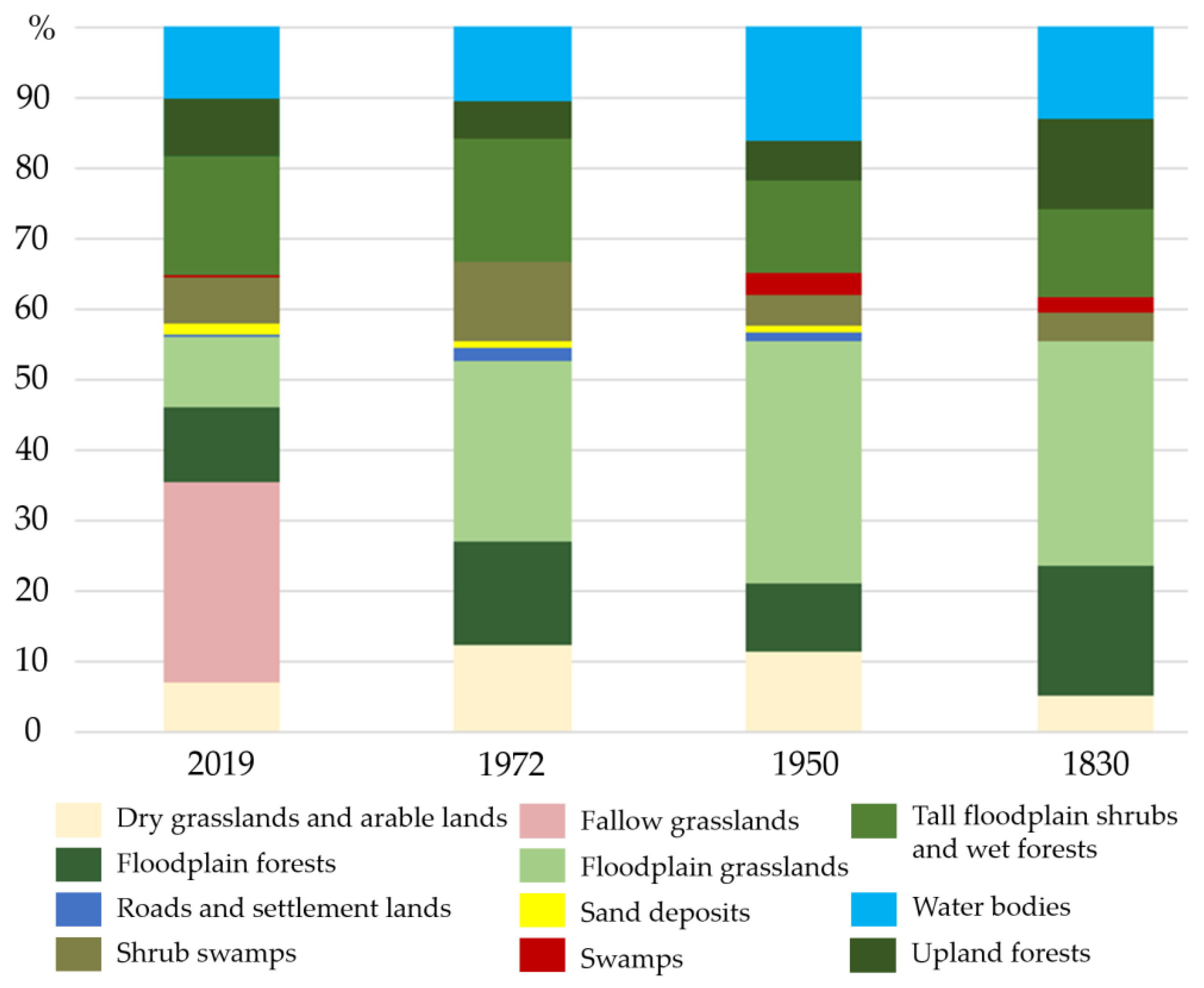
3.1. Landscape Changes Identified by Comparison of Four Multitemporal Layers

The 1830s map of the Tomsk region (Figure A1), similar to all cartographic materials of that time, is inferior to modern ones in terms of accuracy and has many distortions, which complicated the georeferencing. The most reliable points for georeferencing the map proved to be the confluence of the Ob River channels. We recognized the following types of lands on this map: upland grasslands and crops; floodplain forests; floodplain grasslands; residential areas; shrub swamps; swamps; tall floodplain shrubs and wet forests; upland forests; and water bodies (Figure 2A).
The average size of the delineated contours of the 1830 topographic map is 26.5 ha, and the minimum and maximum sizes are 0.5 and 5.5 ha, respectively. The open landscapes within the floodplain form the largest contours (up to 12.9 ha). Comparatively, the smaller areas are marshes, for which the average size of the contours is equal to 2403.8 ha. A large massif of riverside forests and large shrub thickets is located on the island on the northern part of the map. The largest massif of forests, with an area of 3070.4 ha, is located outside the floodplain on the interfluvial terrace on the western part of the map.
We present the results of the interpretation and classification of the 1950s map in Figure 2B. The legend of this topographic map, which was elaborated 110 years later, is generally similar to the previous map. Agricultural land is not indicated on the presented map but is represented by a single layer with grasslands with no indication of the location or area of arable land. The contours highlight the area that is larger on average (46.4 ha) than that on the previous map because it is less detailed. The open landscapes highlighted in white represent the largest areas.
This map lacks details. However, the accurate instrumental methods used for its construction allow for an interpretation of the selected contours with a high degree of reliability, which made it possible to calculate the area of the main channel of the Ob River.
The next archival source that we subjected to interpretation and classification was the space image of the CORONA mission. We present the results in Figure 2C. The contours on this map have more indented boundaries, and the average contour size (16.4 ha) is also noticeably lower. According to the image-texture analysis, all the available open landscapes, except for the treeless sedge marshes, were involved in agriculture at the time of the survey. Their areas amounted to 13,926.2 ha, or 37.8% of the total area.
We obtained the most detailed contours from the interpretation of the modern Sentinel-2 satellite image 26.08.2019 (Figure 2D). The average area of the contours was 1.6 ha. Since 1972, a large area of abandoned grasslands has been forming in the central part of the floodplain, which was previously the most developed territory within the considered landscape. As shown in Figure 3, the proportion of fallow lands in the entire area of the study area was 27.7% (10,445.8 ha) of abandoned land. The area of floodplain grasslands used as hayfields was 3466 ha (9.93%). Since the early 1970s, the area of hayfields has decreased by 3/4.
By 2019, hayfields were being preserved only in the northern and southern parts of the study area. The largest amount of abandoned land is in the central part of the floodplain. A large mass of abandoned land adjoins the northwestern part of the village of Nikolskoye. In the 1970s and 1980s, grasslands were actively created from waterlogged lands by the laying of drainage ditches. By 2019, most of these artificial grasslands had been abandoned and only remained in the south of the studied area, as well as beyond. The reduction in the range of arable lands on the left-bank terraces of the Ob River was much smaller in area. Moreover, a part of the land, which we deciphered as grasslands, changed from arable land to hay grasslands. Depending on the climatic parameters of the year, the area of hayfields in each particular year was different; therefore, both within the terraces and on the floodplain, the boundaries between the fallow lands and hay grasslands are not fixed.

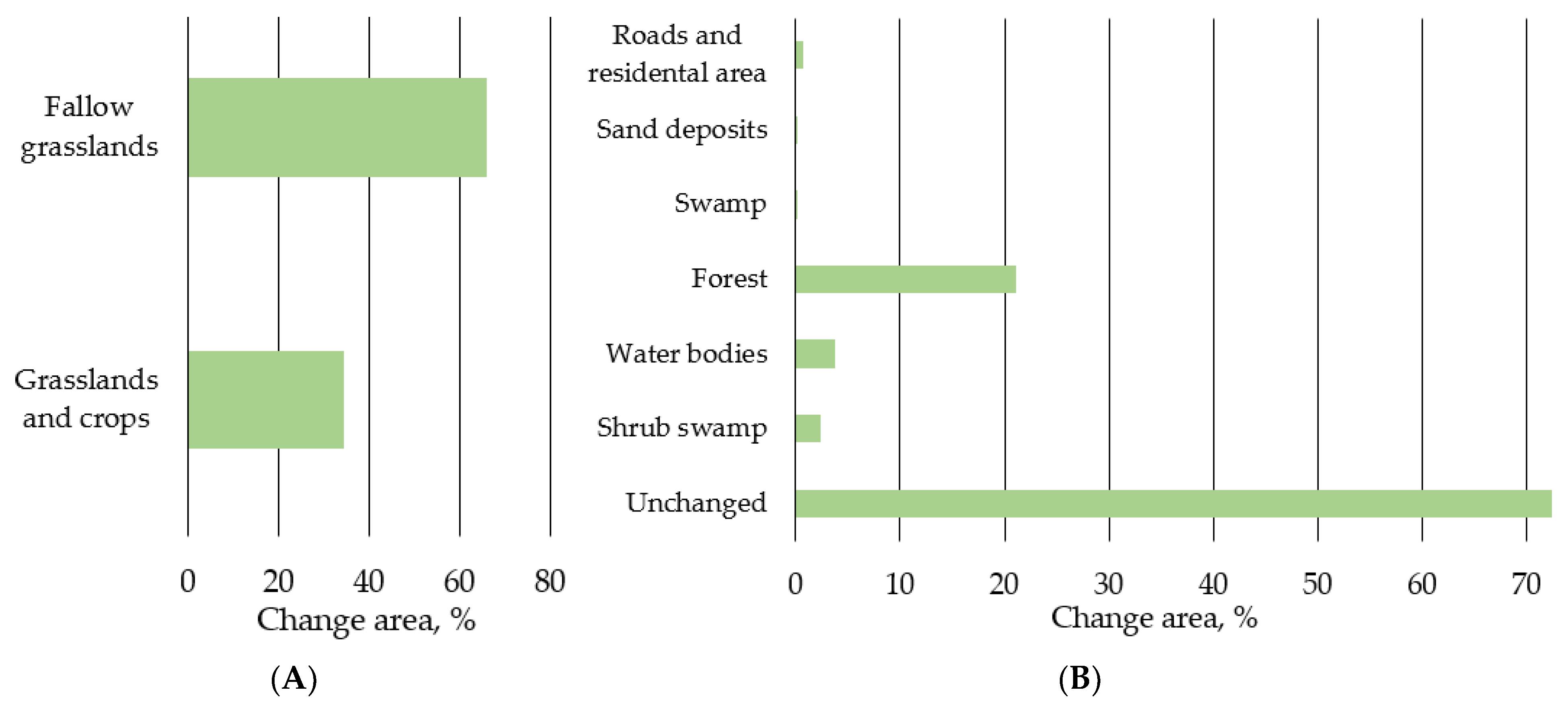
3.2. Land Dynamics according to 1910 Large-Scale Survey

On the land plan of the village of Kaibasovo from 1910, the average size of the contours is 8.5 ha (Figure 4). The classification given in the map legend is quite different from previous maps due to the greater level of detail. For example, the cartographers classified all the forests based on the logic of their economic use, and they divided the swamps into hummocks and closed deciduous forests. The cartographic materials and remote sensing data for later periods correspond to those used in the previous part of this paper (USSR topographic map of the 1950s, CORONA, Sentinel-2A).
We observed several important differences in the comparison of the modern landscape with its former structure represented on the archival map (Figure 5). The first difference was the presence of a large tract road that connected the Tomsky and Narymsky districts. At that time, it passed through the lands of the village of Kaibasovo. The land of the village directly bordered the land of the large roadside village of Nikolskoye; thus, one of its uses was to serve the tract by providing a resource for haymaking, which was important for the provision of the horses used for transportation. According to the explication, 361.36 tithes (394.8 ha) were allotted for haymaking, which exceeded the area of open unswamped grasslands. In addition to the large-scale harvesting of hay to maintain the tract, it was necessary to maintain its passibility by shallow plowing, trampling, and clearing. Now, there is only a local field road on the site of the tract, and the highway has moved several tens of kilometers to the west, outside of the Ob floodplain. The dead end of this area of the floodplain and the lack of equipped roads have led to the abandonment of the agricultural land. In 2019, this territory had one apiary, one recreation center, and the “Kaibasovo” Research Station owned by Tomsk State University. The total area occupied by these facilities is not more than two hectares. Moreover, this area is actively visited by fishermen and hunters.

4. Discussion

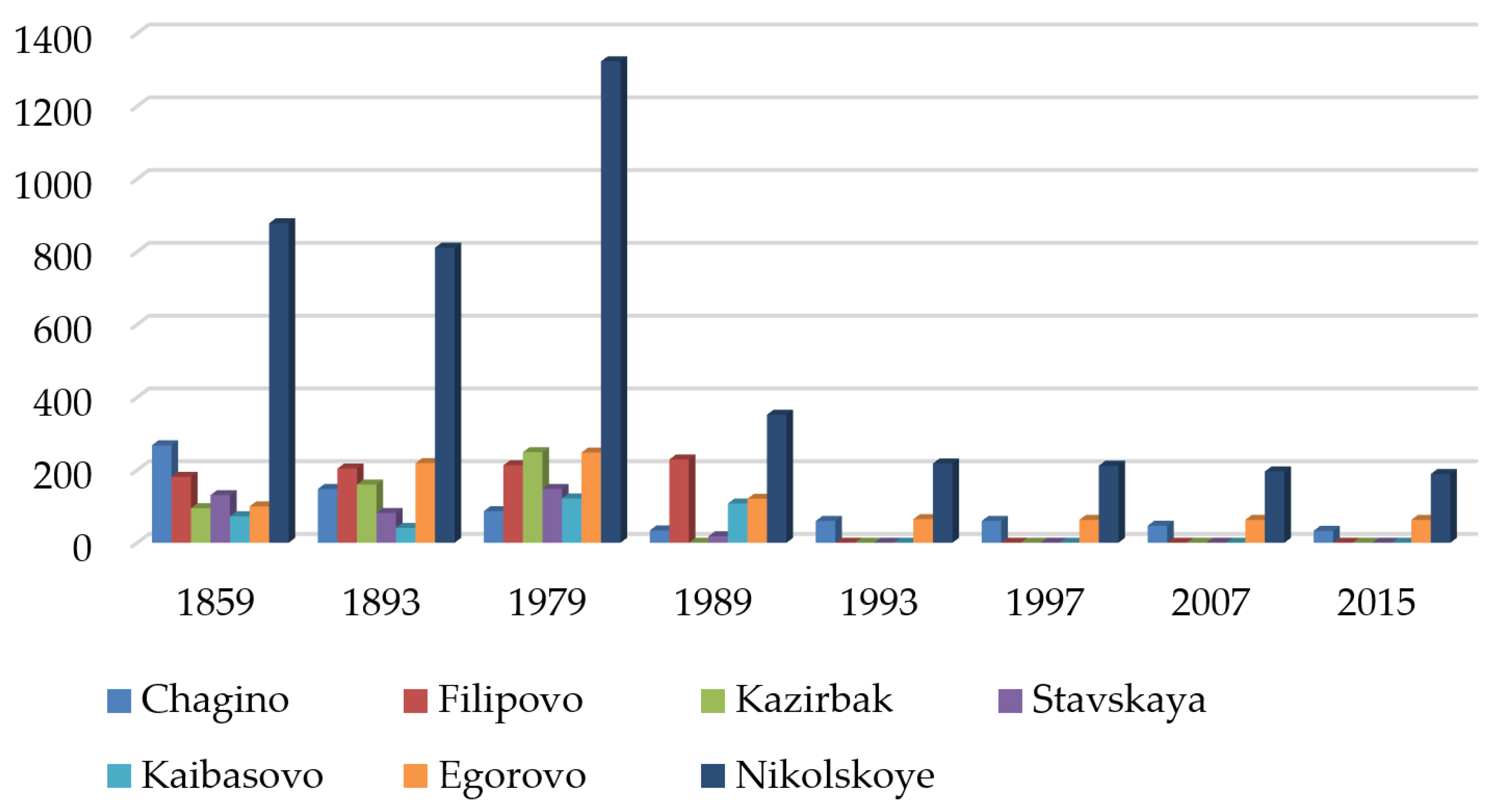
4.1. Dynamics of Settlement and Human Population Patterns

Social processes and population change have substantial impacts on landscape dynamics (Figure A1); thus, we considered the dynamics of the rural population within the study area. During the Russian Empire, to which the first period corresponds, about 1800 people lived in the study area, and they were unevenly distributed among seven settlements (Figure 6). By the turns of the 19th and 20th centuries, the populations were beginning to rapidly increase, which was influenced by the Stolypin reform, according to which many peasants from European Russia were resettled in Siberia [71]. With the transition to state administration, the population of the many villages and towns grew to a peak of 2387 in 1979. After the transition to a market economy [72,73], the population began to decline, and it amounted to 306 people by the mid-2000s.
The maximum number of the population in the study area (2387 people) (Figure 7) was associated with both the natural growth and previous resettlement in the first half of the 20th century [74]. Rural depopulation has taken place over the past 40 years due to the transition to a market economy and the collapse of the Soviet Union, and especially in high-risk agricultural areas, such as the study area [73,74,75,76]. The described population fluctuations also affected the land dynamics. The maximum number of people associated with the period of swamp reclamation and the strong depopulation of recent decades are especially noticeable. The decrease in the numbers of the local populations substantially changes the appearances of landscapes [77], which we can clearly see from the appearance over the last 30 years of a substantial proportion of fallow lands in the structures of the land areas of the floodplains of the middle reaches of the Ob.

4.2. Factors of Land-Use Dynamics in Middle Ob Floodplain

The agricultural development of the southern part of the forest zone of Western Siberia started at the beginning of the 17th century [75]. According to the 1830s map, by that time, the floodplain territory had been largely transformed, as evidenced by the large area of grasslands on the floodplain elevations. Considering that these maps were largely prepared based on the direct perceptions of peasants and interviews with them, we can conclude that the floodplain was perceived by the topographers of the time as generally unforested open space. On the contrary, the terraces above the floodplain were mostly covered with forest, the existing fields were narrow and elongated along the margins of the valleys, and parts of the forests had a park-like appearance, which was associated with their use as pastures. Deciduous species dominated the forests, mainly birches, while coniferous forests were only observed in the swamps. The brown color on the map indicates the forests of the swamps or terraces of the Shegarka River, with a predominance of conifers. The shrubs primarily developed in swampy areas, as well as along riverbeds, on the young deposits of the channel alluvium.
The next chronological phase corresponds to the period of the active development of the territory and the introduction of new lands into agricultural circulation during the existence of the Soviet Union. As a result of the changed government and due to collectivization, collective farms were created and some villages were enlarged. Roads were built to the settlements that were not affected by the enlargement, the total length of which was 180.2 km in the 1950s. Large forested areas in the west and southwest of the study area were clearcut for agricultural needs; the area of the largest destroyed forested area was 6890 ha. According to a comparison with the previous layer, the most notable increase was in the area of the contours of the open landscapes, which was due to the increased density of the population, as well as the intensification of agriculture associated with its industrialization and the introduction of machinery, which occurred from the 1930s to the 1950s.
A total of 60 collective farms existed in the district of Krivosheinsky in the 1950s, while the Tugansky and Tomsky districts, which were the most developed, had 120 and 101 collective farms, respectively [78]. A transport network was developed in the area in 1972, and melioration works were actively carried out. The purpose of the melioration was to increase the areas of hayfields and pastures. At that time, this section of the Ob floodplain served as a hay-harvesting area, and barges delivered the hay to the north of the Tomsk region and to the Khanty-Mansi Autonomous District [22]. The agricultural lands available at that time had already been fully developed; thus, the swampy lands covered with shrubs were put to use. Despite the fact that two settlements had disappeared since the 1950s, the area of agricultural land had increased. According to these facts, at the time that the CORONA satellite imagery was taken, all the agricultural lands in the study area were in use, and there were no fallow grasslands.
The restructuring of the Soviet political and economic system (perestroika) in the 1990s, and the transition to a market economy led to the large-scale abandonment of the agricultural land and the exodus of the rural population by 2019. We identified fallow lands throughout the study area. The largest fallow lands are located on the floodplain terrace and amount to 15,525 ha. The created meliorative system has been completely abandoned, which is a large prone plot of fallow land with an area of 5810 ha. Converted into agricultural land by 1950, the forest area in the west of the study area has been partially restored, and the area of new forests is 2814 ha. The area of active arable land in the study area is the largest one and has attained 3613 ha. The length of the road has been reduced to 79.6 km. The area of farms is shrinking due to the reduction in and aging of the rural population.
The total area of grasslands over the analyzed period has been constantly increasing, which is partially due to the reclamation drainage works of the second half of the 20th century (7.63% of the total area), as well as to clearcutting of the forests on the terraces that are adjacent to the floodplain in the west (7.65% of the total area). A thirty-year period of abandonment has not caused a substantial decrease in the area of grassland ecosystems; however, their status has changed from the category of mowed grasslands and pastures to the category of fallow grasslands (Figure 7A). The states of almost all the fallow grasslands are in the initial stage of forest succession. We observed irregular and irregular-group distributions of willow shrubs, birches, and aspen trees among the meadows. By 2019, only 21% of the meadows were covered with the crowns of trees and shrubs, to the extent that these lands could be classified as forests (Figure 7B). Part of the reclaimed meadows has been transformed into shrub swamps (2.3%).

4.3. The 200-Year Sustainability of Grassland Ecosystems and Future of Grasslands

Despite the vast areas of abandoned agricultural lands in Western Siberia, the current state of these lands and their successional tracks are largely unstudied [79]. In our study, we demonstrated that, in the southern part of the forest zone of Siberia, the floodplain ecosystems of the ridges have been managed by humans for centuries. The state maps of the early 20th century contain land designations such as the “old-timer’s area”. These are places that were developed more than one hundred years ago at the time that the maps were created (late 19th century), and when the population no longer remembered how these areas were developed. The nature of these regions has been completely changed by agricultural practices. The meadows in the forest zone often formed due to human activities [80], and it is logical to assume that the mesophytic grasslands did not arise with the beginning of Russian colonization in the 17th century, but only gradually expanded their range. In earlier periods, during most of the Holocene, there were many archaeological settlements in the Ob valley [81,82], and landscape fires constantly broke out [83]. These influences may have supported the existence of the grasslands and isolated meadows.
The formed meadow ecosystems have a complex vertical structure and functioning, which indicates their effectiveness as ecosystems, and that they were formed even before the widespread development of the floodplain landscapes [84]. According to paleoenvironmental studies, grasslands with high biodiversity are often older than traditionally thought [85,86]. Therefore, it may well be that the meadow ecosystems of the Ob floodplain are ancient and require the development of a special nature management regime to support their existence. The preservation of traditionally managed agricultural landscapes is of paramount importance to prevent the loss of biodiversity [87] at both the species and ecosystem levels. Old pastures are especially valuable [88]. According to the route observations and an analysis of the detailed satellite images, the abandoned pastures and meadows under floodplain conditions are quite resistant to the overgrowth of shrubs and trees by the ecosystems. Even thirty years later, at best, the shrub cover has reached 10–30%, which is a significantly slower rate of the overgrowth of grassy ecosystems with forests than is usually the case on fallow lands in the forest zone [26,27,31]. However, the further unregulated development of the ecosystems could lead to the shrubification and reforestation of the floodplain. As noted, in forest landscapes, grassland ecosystems support the species pool of the Pleistocene herbivorous environment, which, after the disappearance of the Pleistocene megafauna, was saved by traditional farming and animal husbandry [87,89]. The modern approaches to nature protection involve combining strategies for moderate interventions in nature along with the presence of sites where the restoration and self-regulation of ecosystems take place [90]. From this position, the current mode of the land use of the middle Ob floodplains is optimal for biodiversity conservation, an example of which is the restoration of the beaver population on the Ob floodplain [91]. The results obtained are of limited application to the floodplain conditions; however, following some studies [85], they indicate that, in many forest areas, there are large areas in which meadow ecosystems have had substantial stability over time and are slowly becoming overgrown with forests.

5. Conclusions

Our study provides a close look at the land-use changes over the past two centuries, including the period of profound change over the past 30 years, in the southern forest zone of Western Siberia, on a site that is the world’s second largest floodplain. Key trends emerged in the geoinformation analyses of several historical maps and satellite images.
In total, 160 out of 190 years of the studied landscape dynamics are characterized by substantial areas of developed land, and only in recent years have large areas of abandoned land formed on the floodplain. By the 1830s, all the land that was suitable for haymaking and plowing (rarely flooded and not swamped) had been put to agricultural use. By the beginning of the 20th century, the lands of the terraces, which adjoin the floodplain in the east, had also been largely developed. The maximum development of the floodplain occurred in the 1980s, when the previously marshy land was put to use due to the construction of drainage systems. The decline in the population led to the abandonment of the previously developed lands. The grasslands became fallow lands, the meliorative systems were abandoned and waterlogged, and the forests used for grazing became overgrown. Many settlements with developed vegetable farming and cattle breeding were abandoned. We can see the restoration of the forests and shrubs due to the abandoned agriculture in small-to-moderate amounts. The abandoned grassland ecosystems have demonstrated substantial persistence over time.
Our study is the first attempt at a cartographic analysis of the land-use history of the south of Siberia over the past two centuries. The obtained results lay the foundation for expanding our knowledge of the landscape-scale anthropogenic land use in this globally important region. Improvements are urgently needed, including the deployment of denser timeseries images with moderate spatial resolutions to estimate the agricultural land-use dynamics in the surrounding areas, as well as more accurate estimates for the past four decades. We require new studies to assess the land-use changes outside of the floodplains, as well as on the floodplains of the Ob River to the north and south, and on the floodplains of other large Siberian rivers. Integrative research should be aimed at assessing the degree of the transformation of the landscapes in past centuries to assess the degree of human intervention to improve the protection and restoration of the natural environment.

Author Contributions

Conceptualization, S.L. and V.I.; methodology, V.I. and S.L.; software, V.I. and I.M.; validation, A.K. and V.I.; investigation, V.I.; writing—original draft preparation, S.L. and V.I.; visualization, V.I.; supervision, A.K. All authors have read and agreed to the published version of the manuscript.

Funding

This research was funded by Project CarboRus: Stability and Functions of Soil Carbon in Agroecosystems of Russia (075-15-2021-610). We conducted the reported study using the equipment of the Unique Research Installation “System of experimental bases located along the latitudinal gradient” TSU, with financial support from the Ministry of Education and Science of Russia (RF-2296.61321X0043, 13.УHУ.21.0005, agreement No. 075-15-2021-672).

Institutional Review Board Statement

Not applicable.

Informed Consent Statement

Not applicable.

Data Availability Statement

Not applicable.

Acknowledgments

We are grateful to Kelly O’Hoski for editing the English language.

Conflicts of Interest

The authors declare no conflict of interest.

Appendix A

Figure A1. 1830 map of Tomsk province.
Land 11 02258 g0a1
Figure A2. 1910 geometric plan of village of Kaibasovo.
Land 11 02258 g0a2

References

  1. Kaplan, J.O.; Krumhardt, K.M.; Ellis, E.C.; Ruddiman, W.F.; Lemmen, C.; Goldewijk, K.K. Holocene Carbon Emissions as a Result of Anthropogenic Land Cover Change. Holocene 2011, 21, 775–791. [Google Scholar] [CrossRef] [Green Version]
  2. Ruddiman, W.F.; Fuller, D.Q.; Kutzbach, J.E.; Tzedakis, P.C.; Kaplan, J.O.; Ellis, E.C.; Vavrus, S.J.; Roberts, C.N.; Fyfe, R.; He, F.; et al. Late Holocene Climate: Natural or Anthropogenic? Rev. Geophys. 2016, 54, 93–118. [Google Scholar] [CrossRef] [Green Version]
  3. Stephens, L.; Fuller, D.; Boivin, N.; Rick, T.; Gauthier, N.; Kay, A.; Marwick, B.; Geralda, C.; Armstrong, D.; Barton, C.M.; et al. Archaeological Assessment Reveals Earth’s Early Transformation through Land Use. Science 2019, 365, 897–902. [Google Scholar] [CrossRef] [Green Version]
  4. Adame, P.; Cañellas, I.; Moreno-Fernández, D.; Packalen, T.; Hernández, L.; Alberdi, I. Analyzing the Joint Effect of Forest Management and Wildfires on Living Biomass and Carbon Stocks in Spanish Forests. Forests 2020, 11, 1219. [Google Scholar] [CrossRef]
  5. Moya, D.; Sagra, J.; Lucas-Borja, M.E.; Plaza-Álvarez, P.A.; González-Romero, J.; De Las Heras, J.; Ferrandis, P. Post-Fire Recovery of Vegetation and Diversity Patterns in Semiarid Pinus Halepensis Mill. Habitats after Salvage Logging. Forests 2020, 11, 1345. [Google Scholar] [CrossRef]
  6. Wang, L.; Yan, J.; Mu, L.; Huang, L. Knowledge Discovery from Remote Sensing Images: A Review. Wiley Interdiscip. Rev. Data Min. Knowl. Discov. 2020, 10, e1371. [Google Scholar] [CrossRef]
  7. Ellis, E.C.; Gauthier, N.; Goldewijk, K.K.; Bird, R.B.; Boivin, N.; Díaz, S.; Fuller, D.Q.; Gill, J.L.; Kaplan, J.O.; Kingston, N.; et al. People Have Shaped Most of Terrestrial Nature for at Least 12,000 Years. Proc. Natl. Acad. Sci. USA 2021, 118, e2023483118. [Google Scholar] [CrossRef] [PubMed]
  8. Liu, X.; An, Y.; Dong, G.; Jiang, M. Land Use and Landscape Pattern Changes in the Sanjiang Plain, Northeast China. Forests 2018, 9, 637. [Google Scholar] [CrossRef] [Green Version]
  9. Jaworek-Jakubska, J.; Filipiak, M.; Napierała-Filipiak, A. Understanding of Forest Cover Dynamics in Traditional Landscapes: Mapping Trajectories of Changes in Mountain Territories (1824–2016), on the Example of Jeleniogórska Basin, Poland. Forests 2020, 11, 867. [Google Scholar] [CrossRef]
  10. Anderson, B.J.; Armsworth, P.R.; Eigenbrod, F.; Thomas, C.D.; Gillings, S.; Heinemeyer, A.; Roy, D.B.; Gaston, K.J. Spatial Covariance between Biodiversity and Other Ecosystem Service Priorities. J. Appl. Ecol. 2009, 46, 888–896. [Google Scholar] [CrossRef]
  11. Birkhofer, K.; Diehl, E.; Andersson, J.; Ekroos, J.; Früh-Müller, A.; Machnikowski, F.; Mader, V.L.; Nilsson, L.; Sasaki, K.; Rundlöf, M.; et al. Ecosystem Services—Current Challenges and Opportunities for Ecological Research. Front. Ecol. Evol. 2015, 2, 87. [Google Scholar] [CrossRef] [Green Version]
  12. Bürgi, M.; Silbernagel, J.; Wu, J.; Kienast, F. Linking Ecosystem Services with Landscape History. Landsc. Ecol. 2015, 30, 11–20. [Google Scholar] [CrossRef] [Green Version]
  13. Scherreiks, P.; Gossner, M.; Ambarlı, D.; Ayasse, M.; Blüthgen, N.; Fischer, M.; Klaus, V.; Kleinebecker, T.; Neff, F.; Prati, D.; et al. Present and Historical Landscape Structure Shapes Current Species Richness in Central European Grasslands. Landsc. Ecol. 2022, 37, 745–762. [Google Scholar] [CrossRef]
  14. Tikkanen, O.-P.; Chernyakova, I.A. Past Human Population History Affects Current Forest Landscape Structure of Vodlozero National Park, Northwest Russia. Silva Fenn. 2014, 48, 1207. [Google Scholar] [CrossRef] [Green Version]
  15. Henttonen, H.M.; Nöjd, P.; Suvanto, S.; Heikkinen, J.; Mäkinen, H. Size-Class Structure of the Forests of Finland during 1921–2013: A Recovery from Centuries of Exploitation, Guided by Forest Policies. Eur. J. For. Res. 2020, 139, 279–293. [Google Scholar] [CrossRef] [Green Version]
  16. Henebry, G. Carbon in Idle Croplands. Nature 2009, 457, 1089–1090. [Google Scholar] [CrossRef]
  17. Kalinina, O.; Goryachkin, S.V.; Karavaeva, N.A.; Lyuri, D.I.; Giani, L. Dynamics of Carbon Pools in Post-Agrogenic Sandy Soils of Southern Taiga of Russia. Carbon Balance Manag. 2010, 5, 1. [Google Scholar] [CrossRef] [Green Version]
  18. Schierhorn, F.; Müller, D.; Beringer, T.; Prishchepov, A.V.; Kuemmerle, T.; Balmann, A. Post-Soviet Cropland Abandonment and Carbon Sequestration in European Russia, Ukraine, and Belarus. Glob. Biogeochem. Cycles 2013, 27, 1175–1185. [Google Scholar] [CrossRef]
  19. Matasov, V.; Prishchepov, A.V.; Jepsen, M.R.; Müller, D. Spatial Determinants and Underlying Drivers of Land-Use Transitions in European Russia from 1770 to 2010. J. Land Use Sci. 2019, 14, 362–377. [Google Scholar] [CrossRef]
  20. Halicki, W.; Kulizhskiy, S. Changes in Arable Land Use in Siberia in the 20th Century and Their Effect on Soil Degradation. Int. J. Environ. Stud. 2015, 72, 456–473. [Google Scholar] [CrossRef]
  21. Halicki, W.; Kita, K. The Past, Present, and Future of the Use of the Agricultural Soils of Siberia. Sib. Ecol. Divers. Environ. Impact 2016, 32, 21–52. [Google Scholar]
  22. Khromykh, V.S. Landscape-melioration studies on the floodplain of the Middle Ob. Quest. Geogr. Sib. 1978, 124–131. Available online: http://vital.lib.tsu.ru/vital/access/manager/Repository/vtls:000047932 (accessed on 7 November 2022). (In Russian).
  23. Dyukarev, E.; Alekseeva, M.N.; Golovatskaya, E. Study of Wetland Ecosystem Vegetation Using Satellite Data. Izv. Atmos. Ocean. Phys. 2017, 53, 1029. [Google Scholar] [CrossRef]
  24. Khitrov, N.; Loiko, S. Soil Cover Patterns on Flat Interfluves in the Kamennaya Steppe. Eurasian Soil Sci. 2010, 43, 1309–1321. [Google Scholar] [CrossRef]
  25. Smirnova, O.V.; Bobrovsky, M.; Khanina, L.; Zaugolnova, L.B.; Shirokov, A.; Lugovaya, D.L.; Korotkov, V.N.; Spirin, V.; Samokhina, T.Y.; Zaprudina, M.V. Hemiboreal Forests. In European Russian Forests: Their Current State and Features of Their History; Plant and Vegetation; Smirnova, O., Bobrovsky, M., Khanina, L., Eds.; Springer: Dordrecht, The Netherlands, 2017. [Google Scholar] [CrossRef]
  26. Telesnina, V.M.; Kurganova, I.N.; Lopes de Gerenyu, V.O.; Ovsepyan, L.A.; Lichko, V.I.; Ermolaev, A.M.; Mirin, D.M. Dynamics of Soil Properties and Plant Composition during Postagrogenic Evolution in Different Bioclimatic Zones. Eurasian Soil Sci. 2017, 50, 1515–1534. [Google Scholar] [CrossRef]
  27. Telesnina, V.M.; Zhukov, M.A. The Influence of Agricultural Land Use on the Dynamics of Biological Cycling and Soil Properties in the Course of Postagrogenic Succession (Kostroma Oblast). Eurasian Soil Sci. 2019, 52, 1114–1129. [Google Scholar] [CrossRef]
  28. Ryzhova, I.M.; Telesnina, V.M.; Sitnikova, A.A. Dynamics of Soil Properties and Carbon Stocks Structure in Postagrogenic Ecosystems of Southern Taiga during Natural Reforestation. Eurasian Soil Sci. 2020, 53, 240–252. [Google Scholar] [CrossRef]
  29. Post, W.M.; Kwon, K.C. Soil Carbon Sequestration and Land-Use Change: Processes and Potential. Glob. Chang. Biol. 2000, 6, 317–327. [Google Scholar] [CrossRef] [Green Version]
  30. Poeplau, C.; Don, A.; Vesterdal, L.; Leifeld, J.; Wesemael, B.; Schumacher, J.; Gensior, A. Temporal Dynamics of Soil Organic Carbon after Land-Use Change in the Temperate Zone—Carbon Response Functions as a Model Approach. Glob. Chang. Biol. 2011, 17, 2415–2427. [Google Scholar] [CrossRef]
  31. Kurganova, I.N.; Telesnina, V.M.; Lopes de Gerenyu, V.O.; Lichko, V.I.; Karavanova, E.I. The Dynamics of Carbon Pools and Biological Activity of Retic Albic Podzols in Southern Taiga during the Postagrogenic Evolution. Eurasian Soil Sci. 2021, 54, 337–351. [Google Scholar] [CrossRef]
  32. Rolinski, S.; Prishchepov, A.V.; Guggenberger, G.; Bischoff, N.; Kurganova, I.; Schierhorn, F.; Müller, D.; Müller, C. Dynamics of Soil Organic Carbon in the Steppes of Russia and Kazakhstan under Past and Future Climate and Land Use. Reg. Environ. Chang. 2021, 21, 73. [Google Scholar] [CrossRef]
  33. Arkhipova, M.V. Variation in Forest Area on the Central Russian Upland within the Last 250 Years. Contemp. Probl. Ecol. 2015, 8, 830–837. [Google Scholar] [CrossRef]
  34. Terekhin, E.A.; Chendev, Y.G. Satellite-Derived Spatiotemporal Variations of Forest Cover in Southern Forest–Steppe, Central Russian Upland. Contemp. Probl. Ecol. 2019, 12, 780–786. [Google Scholar] [CrossRef]
  35. Rautiainen, A.; Virtanen, T.; Kauppi, P.E. Land Cover Change on the Isthmus of Karelia 1939–2005: Agricultural Abandonment and Natural Succession. Environ. Sci. Policy 2016, 55, 127–134. [Google Scholar] [CrossRef]
  36. Chagin, G.N. Adaptation to the Natural Environment and Traditional Culture of the Russian Population of the Pechora and Kolva Rivers in the 19th—First Quarter of the 20th Centuries. Russ. J. Ecosyst. Ecol. 2017, 2. (In Russian) [Google Scholar] [CrossRef] [Green Version]
  37. Chagin, G.N. The Natural Environment in the Historical Memory of the Peoples of the Perm Region in the XIXth—XXI Centuries. Anthropog. Transform. Nat. Environ. 2017. Available online: https://atps.psu.ru/index.php/antr/article/view/163 (accessed on 7 November 2022). (In Russian).
  38. Aleinikov, A. The Fire History in Pine Forests of the Plain Area in the Pechora-Ilych Nature Biosphere Reserve (Russia) before 1942: Possible Anthropogenic Causes and Long-Term Effects. Nat. Conserv. Res. 2019, 4, 21–34. [Google Scholar] [CrossRef] [Green Version]
  39. Kämpf, I.; Mathar, W.; Kuzmin, I.; Hölzel, N.; Kiehl, K. Post-Soviet Recovery of Grassland Vegetation on Abandoned Fields in the Forest Steppe Zone of Western Siberia. Biodivers. Conserv. 2016, 25, 2563–2580. [Google Scholar] [CrossRef]
  40. Nguyen, H.; Hölzel, N.; Völker, A.; Kamp, J. Patterns and Determinants of Post-Soviet Cropland Abandonment in the Western Siberian Grain Belt. Remote Sens. 2018, 10, 1973. [Google Scholar] [CrossRef] [Green Version]
  41. Barsukov, E.; Chernaya, M. Problems and prospects of studying the history of the development of the Poros river valley in the Tom-Ob interfluve in the 17th–18th centuries: Sources and methods. Ural Hist. J. 2020, 67, 52–60. [Google Scholar] [CrossRef]
  42. Adamov, A. Agriculture of the Peoples of Western Siberia in the Middle Ages (Review of Sources). Tyumen State Univ. Her. Humanit. Res. Humanit. 2018, 4, 152–173. [Google Scholar] [CrossRef]
  43. Zagvazdin, E.P.; Rudaya, N. Palynological Research in the Tobolsk Irtysh Region. Probl. Archaeol. Ethnogr. Anthropol. Sib. Neighboring Territ. 2019, 25, 396–401. [Google Scholar] [CrossRef]
  44. Loiko, S.; Kuz’mina, D.; Dudko, A.; Konstantinov, A.; Vasil’eva, Y.; Kurasova, A.; Lim, A.; Kulizhskiy, S. Charcoals in the Middle Taiga Podzols of Western Siberia as an Indicator of Geosystem History. Eurasian Soil Sci. 2022, 55, 176–192. [Google Scholar] [CrossRef]
  45. Wertebach, T.-M.; Hölzel, N.; Kämpf, I.; Yurtaev, A.; Tupitsin, S.; Kiehl, K.; Kamp, J.; Kleinebecker, T. Soil Carbon Sequestration Due to Post-Soviet Cropland Abandonment: Estimates from a Large-Scale Soil Organic Carbon Field Inventory. Glob. Chang. Biol. 2017, 23, 3729–3741. [Google Scholar] [CrossRef]
  46. Kurganova, I.N.; Lopes De Gerenyu, V.O.; Lichko, V.I.; Smolentseva, E.N.; Smolentsev, B.A.; Semenova, M.P. Influence of Land Use on the Physical Properties of Chernozems in the Forest-Steppe Zone of Western Siberia. Eurasian Soil Sci. 2021, 54, 1337–1349. [Google Scholar] [CrossRef]
  47. Vorobyev, S.N.; Pokrovsky, O.S.; Kirpotin, S.N.; Kolesnichenko, L.G.; Shirokova, L.S.; Manasypov, R.M. Flood Zone Biogeochemistry of the Ob River Middle Course. Appl. Geochem. 2015, 63, 133–145. [Google Scholar] [CrossRef]
  48. Zemtsov, V.A.; Vershinin, D.A.; Khromykh, V.V.; Khromykh, O.V. Long-Term Dynamics of Maximum Flood Water Levels in the Middle Course of the Ob River. IOP Conf. Ser. Earth Environ. Sci. 2019, 400, 012004. [Google Scholar] [CrossRef]
  49. Domrachev, A.A.; Korotkov, Y.A.; Kuzikov, V.I. On the Problem of Floods on the Example of the Siberian Federal District. Nat. Technog. Risks (Phys. Math. Appl. Asp.) 2012. Available online: https://igps.ru/Content/publication/documents/Прирoдные%20риски%20№%201-2012_637508783570836797.pdf (accessed on 7 November 2022). (In Russian).
  50. Tkachenko, P.N.; Kuleshov, P.V.; Bogomolov, V.A.; Vakorin, M.V. Features of Organization of Protection of Population and Territory during the Spring Flooding in the Tomsk Region. Fire Technosphere Saf. Probl. Ways Improv. 2020. Available online: https://elibrary.ru/zevsvd (accessed on 7 November 2022). (In Russian).
  51. Arce-Nazario, J.A. Human Landscapes Have Complex Trajectories: Reconstructing Peruvian Amazon Landscape History from 1948 to 2005. Landsc. Ecol. 2007, 22, 89–101. [Google Scholar] [CrossRef]
  52. Armenteras, D.; Murcia Garcia, U.; Gonzalez, T.; Baron-Ruiz, O.; Arias, J. Scenarios of Land Use and Land Cover Change for NW Amazonia: Impact on Forest Intactness. Glob. Ecol. Conserv. 2019, 17, e00567. [Google Scholar] [CrossRef]
  53. Garcia, A.S.; Vívian, V.M.; Rizzo, R.; West, P.; Gerber, J.S.; Engstrom, P.M.; Maria, M.V. Assessing Land Use/Cover Dynamics and Exploring Drivers in the Amazon’s Arc of Deforestation through a Hierarchical, Multi-Scale and Multi-Temporal Classification Approach. Remote Sens. Appl. Soc. Environ. 2019, 15, 100233. [Google Scholar] [CrossRef]
  54. Lee, J.; Cardille, J.A.; Coe, M.T. Agricultural Expansion in Mato Grosso from 1986–2000: A Bayesian Time Series Approach to Tracking Past Land Cover Change. Remote Sens. 2020, 12, 688. [Google Scholar] [CrossRef] [Green Version]
  55. Souza, C.M.; Shimbo, J.Z.; Rosa, M.R.; Parente, L.L.; Alencar, A.A.; Rudorff, B.F.T.; Hasenack, H.; Matsumoto, M.; Ferreira, L.G.; Souza-Filho, P.W.M.; et al. Reconstructing Three Decades of Land Use and Land Cover Changes in Brazilian Biomes with Landsat Archive and Earth Engine. Remote Sens. 2020, 12, 2735. [Google Scholar] [CrossRef]
  56. Sánchez-Cuervo, A.M.; de Lima, L.S.; Dallmeier, F.; Garate, P.; Bravo, A.; Vanthomme, H. Twenty Years of Land Cover Change in the Southeastern Peruvian Amazon: Implications for Biodiversity Conservation. Reg. Environ. Chang. 2020, 20, 1–14. [Google Scholar] [CrossRef]
  57. Krause, B.; Culmsee, H.; Wesche, K.; Bergmeier, E.; Leuschner, C. Habitat Loss of Floodplain Grasslands in North Germany since the 1950s. Biodivers. Conserv. 2011, 20, 2347–2364. [Google Scholar] [CrossRef] [Green Version]
  58. Francis, R.A.; Petts, G.E.; Gurnell, A.M. Wood as a Driver of Past Landscape Change along River Corridors. Earth Surf. Process. Landf. 2008, 33, 1622–1626. [Google Scholar] [CrossRef]
  59. Zemtsov, V.A. Influence of Physical and Geographic Conditions on the Natural Regulation of the Runoff of the Rivers of the West Siberian Plain. Quest. Geogr. Sib. 1979, 46–58. Available online: https://elibrary.ru/webvhj (accessed on 7 November 2022). (In Russian).
  60. Vasilyev, S.V. Buried peatlands of the Middle Ob floodplain. Bull. Comm. Quat. Res. 1988, 131–136. Available online: https://cyberleninka.ru/article/n/pogrebennye-torfyaniki-poymy-sredney-obi (accessed on 7 November 2022). (In Russian).
  61. Khromykh, V.S. Dynamics and Functioning of Floodplain Landscapes. Belarusian State Univ. 2018, 77–79. Available online: https://elib.bsu.by/bitstream/123456789/209457/1/77-79.pdf (accessed on 7 November 2022). (In Russian).
  62. Savichev, O.G.; Hen, Y. Hydrogelogical and hydrological conditions of functioning the obsk and baxin bolot (South-East of the West Siberian plain). Bull. Tomsk. Polytech. Univ. Geo Assets Eng. 2021, 332, 43–56. (In Russian) [Google Scholar] [CrossRef]
  63. Lapshina, E.D. Bogs of South-East Western Siberia: Botanical Diversity, History of Development and Dynamics of Carbon Accumulation in Holocene. Ph.D. Thesis, Tomsk State University, Tomsk, Russia, 2004. (In Russian). [Google Scholar]
  64. Shepeleva, L.F. Structure and Dynamics of Grassland Communities of the Middle Ob Floodplain: A Monograph; Tomsk University Press: Tomsk, Russia, 2019. (In Russian) [Google Scholar]
  65. Gopalakrishnan, L.; Satyanarayana, B.; Chen, D.; Wolswijk, G.; Amir, A.A.; Vandegehuchte, M.B.; Muslim, A.B.; Koedam, N.; Dahdouh-Guebas, F. Using Historical Archives and Landsat Imagery to Explore Changes in the Mangrove Cover of Peninsular Malaysia between 1853 and 2018. Remote Sens. 2021, 13, 3403. [Google Scholar] [CrossRef]
  66. Alshari, E.A.; Gawali, B.W. Development of Classification System for LULC Using Remote Sensing and GIS. Glob. Transit. Proc. 2021, 2, 8–17. [Google Scholar] [CrossRef]
  67. Phiri, D.; Morgenroth, J. Developments in Landsat Land Cover Classification Methods: A Review. Remote Sens. 2017, 9, 967. [Google Scholar] [CrossRef] [Green Version]
  68. Sun, J.; Yang, J.; Zhang, C.; Yun, W.; Qu, J. Automatic remotely sensed image classification in a grid environment based on the maximum likelihood method. Math. Comput. Model. 2013, 58, 573–581. [Google Scholar] [CrossRef]
  69. Jensen, J.R. Introductory Digital Image Processing: A Remote Sensing Perspective; Pearson Education, Inc.: London, UK, 2015; ISBN 9783540773405. [Google Scholar]
  70. Anderson, R.; Hardy, E.E.; Roach, J.T.; Witmer, R.E. A Land Use and Land Cover Classification System for Use with Remote Sensor Data; USGS Professional: Washington, DC, USA, 1976; p. 964. [Google Scholar] [CrossRef] [Green Version]
  71. Kuznetsov, D.V. Stolypin’s Agrarian Reform and the Peasant Community: A New Look at an Old Problem. Sci. About Man Humanit. Stud. 2014. Available online: https://cyberleninka.ru/article/n/agrarnaya-reforma-p-a-stolypina-i-krestyanskaya-obschina-novyy-vzglyad-na-staruyu-problemu (accessed on 7 November 2022). (In Russian).
  72. Shishkin, A.V. Agrarian reforms in Russia as a continuation of the reform ideas of P.A. Stolypin. P.A. Stolypin Volga Institute of Management—Branch of the Russian Academy of National Economy and Public Administration under the President of the Russian Federation. 2012, 255-258. Available online: https://elibrary.ru/tdctlf (accessed on 9 December 2022). (In Russian).
  73. Zbarskaya, I. On the results of 2002 All-Russia population census. Russ. Mirror Stat. All-Russ. Popul. Census 2004, 223–229. Available online: https://cyberleninka.ru/article/n/demograficheskaya-natsionalnaya-i-sotsialnaya-struktura-obschestva-itogi-vserossiyskoy-perepisi-naseleniya-2002-goda (accessed on 7 November 2022). (In Russian).
  74. Erlichman, V.V. Population Losses in the 20th Century: Handbook; Rus. Panorama: Moscow, Russia, 2004; 175p. (In Russian) [Google Scholar]
  75. Rasskazov, S.V. Historical and Geographical Peculiarities of the Population and Economic Development of the South-West of the West Siberian Plain. Proc. Russ. Acad. Sci. Geogr. Ser. 2008. Available online: https://elibrary.ru/inmkeh (accessed on 7 November 2022). (In Russian).
  76. Kuemmerle, T.; Olofsson, P.; Chaskovskyy, O.; Baumann, M.; Ostapowicz, K.; Woodcock, C.E.; Houghton, R.A.; Hostert, P.; Keeton, W.S.; Radeloff, V.C. Post-Soviet Farmland Abandonment, Forest Recovery, and Carbon Sequestration in Western Ukraine. Glob. Chang. Biol. 2011, 17, 1335–1349. [Google Scholar] [CrossRef]
  77. Daskin, J.H.; Stalmans, M.; Pringle, R.M. Ecological legacies of civil war: 35-year increase in savanna tree cover following wholesale large-mammal declines. J. Ecol. 2016, 104, 79–89. [Google Scholar] [CrossRef]
  78. Shipilina, G.V. Agriculture and the Peasantry of the Tomsk Region in the Mid-1940s–Early 1950s. Ph.D. Thesis, Tomsk State University, Tomsk, Russia, 2008. Available online: https://rusneb.ru/catalog/000199_000009_003167244/ (accessed on 7 November 2022). (In Russian).
  79. Bergen, K.M.; Loboda, T.; Newell, J.P.; Kharuk, V.; Hitztaler, S.; Sun, G.; Johnson, T.; Hoffman-Hall, A.; Ouyang, W.; Park, K.; et al. Long-Term Trends in Anthropogenic Land Use in Siberia and the Russian Far East: A Case Study Synthesis from Landsat. Environ. Res. Lett. 2020, 15, 105007. [Google Scholar] [CrossRef]
  80. Evstigneev, O.I.; Gornov, A.V. Protected Lug: Results of thirty year monitoring. Russ. J. Ecosyst. Ecol. 2021, 6. (In Russian) [Google Scholar] [CrossRef]
  81. Zolnikov, I.D.; Nikulina, A.V.; Pavlenok, K.K.; Vybornov, A.V.; Postnov, A.V.; Bychkov, D.A.; Glushkova, N.V. Regularities in the spatial location of archaeological objects in Timks. Ross. Arkheologiia 2020, 1, 22–31. [Google Scholar] [CrossRef]
  82. Bychkov, D.A. Landscape-topografphical features of the location of archaeological sites in the Tomsk-Narym Ob region. Vestn. Tomsk. Gos. Univ. Istor. —Tomsk. State Univ. J. Hist. 2022, 76, 180–191. [Google Scholar] [CrossRef]
  83. Feurdean, A.; Diaconu, A.-C.; Pfeiffer, M.; Gałka, M.; Hutchinson, S.M.; Butiseaca, G.; Gorina, N.; Tonkov, S.; Niamir, A.; Tantau, I.; et al. Holocene wildfire regimes in western Siberia: Interaction between peatland moisture conditions and the composition of plant functional types. Clim. Past 2022, 18, 1255–1274. [Google Scholar] [CrossRef]
  84. Shepeleva, L.F. The role of vertical structure in maintaining the stable functioning of meadow phytocenoses of the Middle Ob floodplain. IOP Conf. Ser. Earth Environ. Sci. 2018, 107, 012093. [Google Scholar] [CrossRef] [Green Version]
  85. Feurdean, A.; Ruprecht, E.; Molnár, Z.; Hutchinson, S.M.; Hickler, T. Biodiversity-rich European grasslands: Ancient, forgotten ecosystems. Biol. Conserv. 2018, 228, 224–232. [Google Scholar] [CrossRef]
  86. Feurdean, A.; Florescu, G.; Tanţău, I.; Vannière, B.; Diaconu, A.-C.; Pfeiffer, M.; Warren, D.; Hutchinson, S.M.; Gorina, N.; Gałka, M.; et al. Recent fire regime in the southern boreal forests of western Siberia is unprecedented in the last five millennia. Quat. Sci. Rev. 2020, 244, 106495. [Google Scholar] [CrossRef]
  87. Eriksson, O. The importance of traditional agricultural landscapes for preventing species extinctions. Biodivers. Conserv. 2021, 30, 1341–1357. [Google Scholar] [CrossRef]
  88. Kuhn, T.; Domokos, P.; Kiss, R.; Ruprecht, E. Grassland management and land use history shape species composition and diversity in Transylvanian semi-natural grasslands. Appl. Veg. Sci. 2021, 24, e12585. [Google Scholar] [CrossRef]
  89. Stevens, N.; Bond, W.; Feurdean, A.; Lehmann, C.E.R. Grassy Ecosystems in the Anthropocene. Annu. Rev. Environ. Resour. 2022, 47, 261–289. [Google Scholar] [CrossRef]
  90. Van Meerbeek, K.; Muys, B.; Schowanek, S.D.; Svenning, J.-C. Reconciling Conflicting Paradigms of Biodiversity Conservation: Human Intervention and Rewilding. BioScience 2019, 69, 997–1007. [Google Scholar] [CrossRef]
  91. Cazzolla Gatti, R.; Callaghan, T.V.; Rozhkova-Timina, I.; Dudko, A.; Lim, A.; Vorobyev, S.N.; Kirpotin, S.N.; Pokrovsky, O.S. The role of Eurasian beaver (Castor fiber) in the storage, emission and deposition of carbon in lakes and rivers of the River Ob flood plain, western Siberia. Sci. Total Environ. 2018, 644, 1371–1379. [Google Scholar] [CrossRef] [PubMed]
Figure 1. Drone views of study area.
Land 11 02258 g001
Figure 2. Land-cover maps at four time points: (A) topographic map from 1830s; (B) topographic map from 1950s; (C) CORONA, 08.1972; (D) Sentinel-2A, 08.2019.
Land 11 02258 g002
Figure 3. Dynamics of landscape areas.
Land 11 02258 g003
Figure 4. Land-cover and land-use maps of village of Kaibasovo: (A) geometrical plan of Kaibasovo from 1910; (B) topographic map from 1950s; (C) CORONA, 08.1972; (D) Sentinel-2A, 08.2019.
Land 11 02258 g004
Figure 5. Dynamics of natural–territorial complexes of site in vicinity of village of Kaibasovo.
Land 11 02258 g005
Figure 6. Population dynamics of villages in study area.
Land 11 02258 g006
Figure 7. Grassland dynamics over a 47-year time period, according to a comparison of the CORONA (1972) and Sentinel-2A (2019) missions: (A) state of grasslands in 2019 with tree and shrub vegetation reduction after 1972; (B) proportion of grasslands transformed into other types of landscapes.
Land 11 02258 g007
Publisher’s Note: MDPI stays neutral with regard to jurisdictional claims in published maps and institutional affiliations.

