Article

Anthropogenic Transformation of the River Basins of the Northwestern Slope of the Crimean Mountains (The Crimean Peninsula)

by
Vladimir Tabunshchik
*,
Roman Gorbunov
and
Tatiana Gorbunova
A.O. Kovalevsky Institute of Biology of the Southern Seas of RAS, 299011 Sevastopol, Russia
*
Author to whom correspondence should be addressed.
Land 2022, 11(12), 2121; https://doi.org/10.3390/land11122121
Submission received: 18 October 2022 / Revised: 1 November 2022 / Accepted: 22 November 2022 / Published: 24 November 2022
(This article belongs to the Section Land Systems and Global Change)

Abstract

:
The territory of the Crimean Peninsula is extensively subject to economic activities. In this connection, there is an ever-increasing impact on the environment. The present paper presents an analysis of the transformation of the area of the largest river basins of the northwestern slope of the Crimean Mountains (basins of the Zapadnyy Bulganak, Alma, Kacha, Belbek, and Chernaya rivers). For this purpose, various indicators characterizing the transformation of the area were calculated: coefficient of anthropogenic transformation; land degradation index; urbanity index; level of anthropogenic transformation; coefficient of absolute and relative intensities of ecological and economic land use distribution. The results show that the anthropogenic transformation of the area defined by the basins of the Zapadnyy Bulganak, Alma, Kacha, Belbek, and Chernaya rivers increases from the southeast to the northwest as the absolute height decreases, and when moving from river source to mouth. Among the basins under consideration, anthropogenic transformation is greatest In the Zapadnyy Bulganak River basin and lowest in the Chernaya River basin. Among the basins under consideration, anthropogenic transformation decreases from north to south in the following order: Zapadnyy Bulganak River basin, Alma River basin, Kacha River basin, Belbek River basin, Chernaya River basin. This is due to reduced impacts of economic activity within each respective basin.

1. Introduction

In connection with the development of economic activity, the constantly increasing anthropogenic impact on land, landscapes, and ecosystems results in an active process of anthropogenic transformation of the ecological space [1,2].
Issues associated with such anthropogenic transformations (change) of land as a result of economic activity have been the subject of active engagement since the twentieth century.
More and more attention is being paid to this issue in the world. Various characteristics of anthropogenic impact are studied: microplastic pollution [3,4], pesticide pollution [5,6], oil pollution [7,8], heavy metal pollution [9,10], and land cover change [11,12]. At the same time, some authors suggest using various indicators for a comprehensive assessment of anthropogenic transformation [13,14,15,16,17]. However, most of these coefficients are based on a qualitative rather than a quantitative assessment, and those that are based on a quantitative assessment are quite difficult to calculate.
River basins experience the greatest impact from anthropogenic activity, due to the fact that historically, rivers are objects of concentration of population and settlements [18] and centers of civilization development [19].
It should be noted that the study of transformation in the river basin is considered by many authors through water pollution in the river [20,21,22] and at the same time these values are extrapolated to the entire river basin. Thus, the transformation of the basin itself and its change are often not studied. At the same time, a large number of research is devoted to the study of anthropogenic transformation of landscapes [23,24,25,26] as well as the emergence of risks arising from these changes [27,28,29]. To achieve the goals of sustainable development and leveling the adverse effects of anthropogenic impact, many researchers use the concept of landscape planning [30,31,32].
In Russia, these issues are currently being investigated both at regional and local levels. Thus, at the regional level, for example, studies are investigating anthropogenic land transformation in the Republic of Tuva [33], geosystems of the Republic of Tatarstan [34], landscapes of Western Yakutia [35], etc. At the local level, e.g., in Stavropol Krai Nefedova M.V. and Kulenko A.S. [36] analyze the anthropogenic transformation of landscapes of the Andropovsky district of Stavropol Krai. Smetanova M.V. et al. [37] present a study of the Staroshaygovsky District in the Republic of Mordovia, Ryabovol I.V. and Mishchenko A.A. [38] focus on the Gulkevichi District of Krasnodar Krai, and Dulova K.A. [39] address the Sol-Iletsky Urban Okrug, etc. Thus, in view of increasing external impacts on the environment occurring at different intensities in different regions, the topic can be said to be extremely relevant.
On the Crimean Peninsula, issues of anthropogenic transformation of landscapes and the individual areas comprising them have been actively investigated since the second half of the twentieth century. Noting that the natural environment of Crimea is actively exposed to economic impacts, authors have conducted mainly qualitative analyses of these impacts during this period [40,41]. However, the most active period of intensive research began in the late 1990s. From their investigation of the transformation of land areas making up the Crimean Plain, Dragan N.A. and Alshevbi F.H.S. [42] indicate that the largest part of the area is occupied by very strongly transformed (41%), strongly transformed (40%), and averagely transformed (15%) landscapes. E.A. Pozachenyuk E.A. [43] notes that “natural weakly transformed landscapes occupy only 2.5% of the total area of the Crimean Peninsula”. The anthropogenic transformation of Crimean landscapes has been studied in the Central Foothills of the Main Ridge of the Crimean Mountains [44], Kerch Peninsula [45], the area surrounding Trudolyubovka village in the Bakhchisarai District [46], etc. Here, a general trend when studying the transformation of the area and landscapes of the Crimean Peninsula can be observed: most such studies are focused on the Crimean Plain and Kerch Peninsula.
A large number of theoretical papers propose various approaches to assessing anthropogenic land transformation [47,48,49]. The works [50,51] include a comparison of various quantitative formulas for assessing anthropogenic transformation.
A number of works [48,51] note that the study of the transformation of the territory is conducted in the context of administrative-territorial units in connection with the need to obtain information about the state of the territory in order to solve management and development problems on behalf of the national economic complex, as well as to simplify processing of the obtained statistical data and provide for their practical application. A significant disadvantage of this approach and most of the above works in general is that the analysis is conducted for territories allocated artificially as a result of economic activity (for example, districts, Federal Subjects, etc.), which in turn fails to consider natural factors and environmental conditions. As has been repeatedly noted by many researchers [52,53], this conflicts with the landscape approach to the organization of a natural area, including its basin structure. Among studies of the anthropogenic transformation of river basins, the following works can be noted [54,55,56,57,58,59,60].
However, here it is necessary to add the caveat that in most cases the river basin is considered as a single whole, which approach fails to allocate subbasins or basins of smaller orders within its limits [56]. At the same time, for the river basins of the Crimean Peninsula, the study of nature management and transformation is extremely fragmented [59,61,62]. For example, in work [59] studying the Salgir River basin, the presented analysis of the anthropogenic transformation of the basin landscapes boils down to a consideration of changes in the territory within the selected units formed by a grid of squares imposed on the area of the basin.
Thus, the study of anthropogenic transformation in Crimea is developing in distinct directions. For one, there is the study of anthropogenic transformation of landscapes of the Crimean Peninsula, where landscapes [44,45] or sometimes units of physical and geographical division act as operational and territorial units of research [63,64]. Another is the study of anthropogenic transformation of individual areas of the Crimean Peninsula [59,65,66], in which the operational-territorial unit is either the territory of the studied area as a whole or individual sections of the territory of the studied area, which can be divided into squares or hexagons of different areas. Thus, the problem of studying the transformation within the river basins of the Crimean Peninsula at the local level of research is clearly indicated.
The purpose of the research is to study the anthropogenic transformation within the basins of the Zapadnyy Bulganak, Alma, Kacha, Belbek, and Chernaya rivers. This is a very important aspect of the study in view of the fact that an increase in anthropogenic transformation leads to space pollution, and this, in turn, increases the risks of providing the region with high-quality resources necessary for the functioning of society within the river basin. The study of the anthropogenic transformation of river basins is closely related to the implementation of the global sustainable development goals (Sustainable Development Goals), approved by the UN General Assembly in 2016 [67], in particular, within the framework of ensuring the rational use of water resources, the resilience and sustainability of cities and towns, the protection of terrestrial ecosystems and the promotion of their rational use, the rational management of forests, halting the process of loss of biological diversity, and a number of other goals.

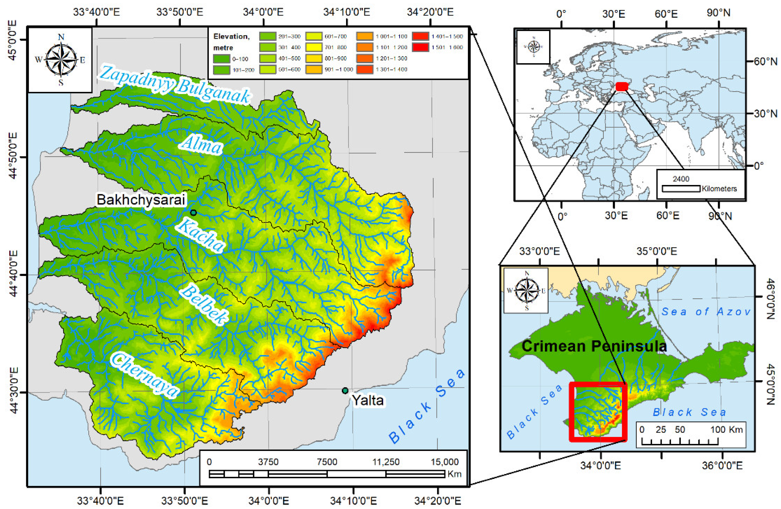
2. Materials and Methods

The basins of the Zapadnyy Bulganak, Alma, Kacha, Belbek, Chernaya rivers are located in the southwestern part of the Crimean Peninsula (Figure 1). The area of the studied territory comprises approximately 2299 square kilometers. The rivers originate in the Crimean Mountains and flow into the Black Sea; their valleys cut through the Inner and Outer ridges of the Crimean Mountains.
The average annual air temperature varies from 8 °C in the upper reaches of the Belbek River basin to 11–12 °C in the estuarine parts of river basins along the Black Sea coastline. The amount of precipitation in the study area varies between more than 1000 mm per year in the upper reaches of the Kacha, Belbek, and Chernaya rivers to less than 350 mm in the lower reaches. The soil cover is represented by brown soils and chernozems (black soils) in the lower reaches of rivers along with steppificated brown mountain-forest and brown mountain soils in the middle and upper reaches. The vegetation cover, which changes from the northwest to the southeast, is represented by the following high-altitude vegetation belts: mixed feather-grass fescue grasslands; downy oak forests in combination with hornbeam; rock-oak forests in combination with hornbeam and ash; beech forests in combination with hornbeam. As a result of economic activity, the vegetation cover has been significantly transformed.
The study of anthropogenic transformation was conducted using geographical information systems. The boundaries of catchment basins were defined using data of the Copernicus GLO-30 Digital Elevation Model [68], on which basis the boundaries of the basins were allocated in semi-automatic mode [69,70]. The Copernicus GLO-30 Digital Elevation Model geodataset for the Crimean Mountains shows higher accuracy than the widely used Shuttle Radar Topography Mission Data (SRTM) geodataset. Data on nature management within the river basins of the northwestern slope of the Crimean Mountains were obtained from decoded high-resolution satellite images. Landsat-8 and Sentinel-2 space images for 2020 and 2021 were used to analyze modern nature management and modern anthropogenic transformation of river basins. The selection of types of nature management was carried out in a semi-automatic mode using field research methods to verify the data.
The calculation of the anthropogenic transformation of the river basins of the northwestern slope of the Crimean Mountains was performed using the ArcGIS 10 software package using the following indicators:
1. Coefficient of anthropogenic transformation, according to Shishchenko P.G. [47] was calculated by the formula:
K = r i p i q n 100
where K is the coefficient of anthropogenic transformation.
  • r i —rank of anthropogenic transformation by type of use (protected areas—1; forests—2; swamps and wetlands—3; meadows—4; gardens and vineyards—5; arable land—6; rural development—7; urban development—8; reservoirs, canals—9; land used for industrial purposes—10).
  • p i —rank area (%).
  • q —index of the depth of transformation (protected areas—1; forests—1.05; swamps, floodplains, wetlands—1.1; meadows—1.15; gardens, vineyards—1.2; arable land—1.25; rural development—1.3; urban development—1.35; reservoirs—1.4; industrial land—1.5).
  • n —number of divisions within the study region.
2. Land degradation index, according to Rulev A.S. [49], was calculated by the formula:
L D I = i = 1 i = m N i S i S s c a n
  • S i is the area of the type of land use, km2, %.
  • N i —rank, or landscape disturbance index (1—forest areas and tree and shrub plantations; 2—under water and swamps; 3—pastures; 4—arable land (including irrigated); 5—industrial-transport and residential areas).
  • S s c a n —scanning area.
  • i —serial number of the type of disturbance.
  • m —number of types of disturbance.
3. Urbanity index, according to Wrbka T. et al. [71], was calculated by the formula:
Urbanity = log 10 U + A F + W + B
where U—denotes urban area; A—agricultural area (cropland, agriculturally used grasslands); F—forest areas; W—water and wetland areas; B—natural or semi-natural biotopes («natural areas»).
4. Degree of anthropogenic transformation, according to Zanozin V.V. [72], was calculated by the formula:
L a n t r o p o = SA 1 k 1 + SA 2 k 2 + + SA n k n S N T C
where SA—area of the modified section of the natural-territorial complex.
  • k —numerical coefficient of the degree of anthropogenic transformation (1—protected areas, undisturbed natural areas; 2—hayfields; 3—grazing, fallow land; 4—cultivated land, arable land, rice paddies; 5—cottages and similar lands; 6—quarries, artificial ponds and water bodies, roads, cemeteries; 7—building development; 8—rural development and adjacent territories; 9—urban development and adjacent territories, industrial type zones).
  • S N T C —area of the natural-territorial complex.
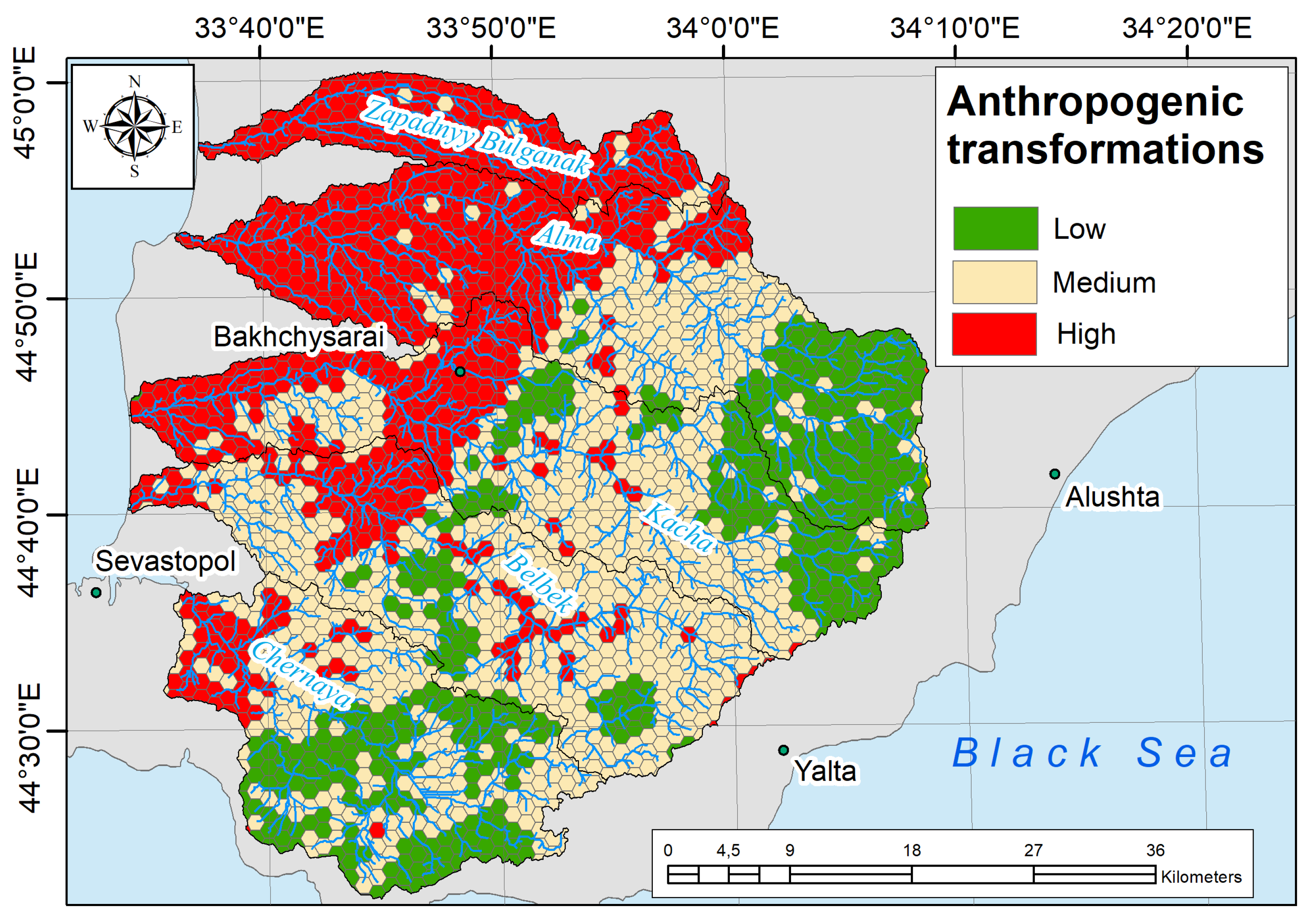
5. The coefficients of absolute and relative tension of the ecological and economic balance of the territory, according to Kochurov B.I. [48], are calculated by the formulas:
K a = P 6 P 1
K o = P 6 + P 5 + P 4 P 1 + P 2 + P 3
where K a —coefficients of absolute tension of the ecological and economic balance of the territory; K o —coefficients of relative tension of the ecological and economic balance of the territory; P 6 —industrial, transport, communications, defense and other disturbed lands, landfills, dumps; P 5 —urban settlements; P 4 arable land, rural settlements; P 3 perennial plantations, pastures, recreational lands, forest lands; P 2 —hayfields, fallow lands, forested lands not used for logging, reserve lands; P 1 —protected areas, water fund lands and other conditionally unused lands.
The calculation of the indicators was conducted both for the basin area as a whole and for the grid of hexagonal cells composing the study area. Here, the extreme difficulty in assessing the degree of anthropogenic transformation for a hexagonal network in the interpretation of Kochurov B.I. [48]—in particular, calculating the coefficients of absolute and relative intensity of the ecological and economic balance of the territory—should be noted. This is due to the fact that the formulas used to estimate the absolute and relative intensity of the ecological and economic balance are fractions; therefore, if zero values are present in the numerator or denominators of this fraction, it is impossible to conduct the relevant calculations. For example, in the southeast of the Alma, Kacha, Belbek, and Chernaya river basins, the area is mainly occupied by forests; moreover, most hexagonal cells do not include industrial facilities, well-defined transport infrastructure, residential development, or disturbed lands. That is, for some hexagons, when calculating the coefficient of absolute tension, the denominator of the fraction will be zero, which leads to an error and the consequent inability to make calculations. In such cases, it is possible to use these coefficients only for the entire basin area or larger operational-territorial units.
At the same time, the formula presented by Kochurov B.I. [48] is interesting because it introduces for calculations the category of unused lands that are subject to minimum values of transformation. Obviously, this represents an advantage compared to the formula presented in [47], which provides a strict distinction between the types of nature management represented in the study area; moreover, it is unclear where to include certain types of nature management that exist but are absent in the classification (for example, mountain slopes without vegetation). At the same time, based on [47], some areas can be attributed to two types of land use (for example, a forest or meadow as part of a protected area). Here, a reasonable question arises concerning how to take this area into account when calculating areas as being covered with forest, as protected areas, or twice, i.e., as two types of use.
Separately, it is worth adding a caveat that, despite methods for assessing anthropogenic transformation being developed to assess the transformation of landscapes, many Russophone authors use them to assess anthropogenic transformation of territories. This is manifested in the case when the area under study is divided into a grid of squares or hexagons and the assessment is made specifically for these operational-territorial units rather than for landscapes or smaller/larger taxonomic landscape units.
Due to the method of Shishchenko P.G. [47] initially being evaluated for the territory of the Ukrainian SSR, it turned out to be necessary when moving to the local level of research to expand the scale of values of the coefficient of anthropogenic transformation. For example, in [73], Alshevbi F.S. points to the necessity of using a more fractional scale of assessment when calculating the coefficient of anthropogenic transformation for agricultural lands of the Crimean Plain, due to the maximum values of the anthropogenic transformation coefficient for the studied area not exceeding 5.0.

3. Results

The coefficients of anthropogenic transformation of the river basins of the northwestern slope of the Crimean Mountains (Zapadnyy Bulganak, Alma, Kacha, Belbek, and Chernaya rivers) calculated using ArcGIS 10 are presented in Table 1.
As can be seen from Table 1, the highest values of transformation indicators are characteristic of the Zapadnyy Bulganak River basin; this is due to the absence of large, protected areas and weakly transformed areas within the basin. At the same time, for the basins of the Alma, Kacha, Belbek, and Chernaya rivers, all the considered indicators, while heterogeneous, are significantly lower. In general, there is a tendency for the anthropogenic transformation indicators in the basins of the northwestern slope of the Crimean Mountains to decrease from north to south, i.e., from the basin of the Zapadnyy Bulganak River to the Chernaya River basin.
To assess the anthropogenic transformation within each basin, the territory under consideration was divided into cells with an area of 1 sq. km having a hexagonal shape; the transformation indicators were calculated for each cell. The obtained results are shown in Figure 2.
Within each basin, the anthropogenic land transformation indicators increase from the southeast to the northwest. The average values obtained from the analysis of the hexagonal polygon network differ from the values calculated for each basin area as a whole (Table 2).
Where the spread of values reaches 50%, the obtained average values calculated on the basis of a grid of hexagonal cells for each basin differ only slightly from the values of the indicators calculated for each basin as a whole, excluding the calculation of the indicators of the urbanity index. At the same time, the general trend also persists—the transformation of the basin territory decreases from the Zapadnyy Bulganak River basin in the north to the Chernaya River basin in the south.
Considering that the above-mentioned formulas for determining anthropogenic transformation operate with almost the same types of land use, including or excluding certain types and assigning them different ranks to assess the transformation, correlation coefficients for the river basins of the northwestern slope of the Crimean Mountains are calculated for selected pairs of indicators in order to assess the relationship between these indicators. A very strong correlation of 0.96 is observed for the pair “coefficient of anthropogenic transformation” and “land degradation index”, as well as for the pair “coefficient of anthropogenic transformation” and “degree of anthropogenic transformation” for which the correlation is 0.92. For the pairs “coefficient of anthropogenic transformation” and “urbanity index”, “urbanity index” and “index of anthropogenic disturbance of land”, and “degree of anthropogenic transformation” and “urbanity index”, the correlation varies from 0.40–0.42, which indicates a weak correlation. Thus, the indicators under consideration can be used as the basis for a comprehensive assessment of the anthropogenic transformation of the considered territory.
An analysis of the four considered indicators allows us to carry out a cluster analysis and identify within the river basins of the northwestern slope of the Crimean Mountains low transformed, medium transformed and high transformed areas. Cluster analysis was performed using the built-in modules of the Quantum GIS software package (module—“Attribute based clustering”). The obtained results are shown in Figure 3.

4. Discussion

According to [73], the area of the river basins of the northwestern slope of the Crimean Mountains (the basins of the Zapadnyy Bulganak, Alma, Kacha, Belbek, and Chernaya rivers) is located within three landscape areas, having different anthropogenic transformation coefficients. According to [73], the basin of the Zapadnyy Bulganak River and the lower reaches of the Alma, Kacha, Belbek, and Chernaya rivers, which are located within the central Crimean plain and foothill-forest-steppe landscape areas, are strongly transformed (6.51–7.4), while the weakly transformed upper reaches of the rivers belong to the mountainous forest with settled meadows landscape area (2.0–3.8). However, according to our calculations, the values of the anthropogenic transformation coefficient within the hexagonal cells were less than 2.0 and more than 8.0, indicating the need to enter additional classes of values. In this connection, in order to allow a large spatial heterogeneity to be shown within each cell of the hexagonal grid, the modified scale of coefficient values presented in [63,74] was used to estimate the coefficient of anthropogenic transformation.
Let us consider the transformation of the territory of the river basins of the northwestern slope of the Crimean Mountains (the Zapadnyy Bulganak, Alma, Kacha, Belbek, and Chernaya rivers) in comparison with other regions of the Crimean Peninsula. Kalinchuk I.V. et al. [63] partially calculated the coefficient of anthropogenic transformation in the lower reaches of the basins of the Zapadnyy Bulganak and Alma rivers as part of their study into the anthropogenic transformation of the Crimean Plain. Thus, the lower part of the basin is characterized by very strongly transformed landscapes, which corresponds to the value of the anthropogenic transformation coefficient from 7.41 to 8. Slightly upstream, the river basin is characterized by highly transformed landscapes, which corresponds to the value of the anthropogenic transformation coefficient from 6.51 to 7.4. Despite the fact that in [63] cells in the form of squares with a side of 5 km are used, these results indirectly correlate with those obtained by us.
Ergina E.I. and Shadrina’s A.Yu. [45] calculation of the coefficient of anthropogenic transformation for the area of the Kerch Peninsula attributed the landscapes of the Kerch Peninsula to the average transformation with a coefficient value of 6.4. The coefficient of anthropogenic transformation for the landscapes of the Central Foothills of the Main Ridge of the Crimean Mountains is calculated by Petlyukova E.A. [75] as 6.52, which corresponds to strongly transformed landscapes. Chekmareva T.M. and Sidorova M.A. [76] calculate the anthropogenic transformation coefficient of the landscapes of the village of Kacha at 9.6, thus allocating this territory to the very strongly transformed category.
T.V. Ivankova [77] performed calculations of the anthropogenic transformation of several key sites located in the Alma River basin according to the method of B.I. Kochurov; however, for the reasons described above, it is not possible to compare these data with ours. Nevertheless, the provided map of the degree of anthropogenic load, comprising a breakdown of the Alma River basin area by load categories, visually correlates with our data.
Aleksashkin I.V. et al. [46] show that the landscapes of the environs of Trudolyubovka village in the Bakhchisarai district of the Republic of Crimea are characterized by an average deviation from the norm of the ecological state; however, again it is not possible to compare these data with the indicators we have considered.
It is interesting to compare the value of the anthropogenic transformation coefficient of the basins under consideration with the transformations occurring in the basins of other rivers of the Crimean Peninsula. Thus, the coefficient of anthropogenic transformation calculated by Pozachenyuk E.A. et al. for the Salgir River basin was 6.1 [59]. Accordingly, the Salgir River basin was attributed to the category of average transformed landscapes. In terms of the spatial distribution of the coefficient of anthropogenic transformation within the Salgir River basin, 0.5% of the basin area is occupied by untransformed (less than 2 points), poorly transformed (2.01–3.8 points; 14%), transformed (3.81–5.3 points; 12%), averagely transformed (5.31–6.5 points; 17%), strongly transformed (6.51–7.4 points; 22%), very strongly transformed (7.41–8.0 points; 32%), and entirely transformed (more than 8 points; 2.5%) landscapes.
By comparing these data with the values of the anthropogenic transformation coefficient within the basins of the rivers under consideration, we can see that they are less transformed (Figure 4), with the exception of the Zapadnyy Bulganak River basin.
This is due to the presence in the river basins of the northwestern slope of the Crimean Mountains (the basins of the Alma, Kacha, Belbek, Chernaya rivers) of large, protected areas and forests, along with a small proportion of arable land, orchards, vineyards, and settlements.
When considering the characteristics of the coefficients of relative and absolute tension of the ecological and economic balance of the territory, we can refer to the work in [78]. Despite the calculation in [78] having been performed for the administrative regions of the Crimea, the obtained data may be partially compared. Since the areas of the river basins in question lie mostly within the city of Sevastopol and the Bakhchysarai district of the Republic of Crimea, it is possible to compare the values. According to [78], for the city of Sevastopol and the Bakhchisarai district of the Republic of Crimea, the coefficient of absolute tension of the ecological and economic balance lies in the range from 1 to 2.9; for the city of Sevastopol, the coefficient of relative tension of the ecological and economic balance is more than 2.5, while for the Bakhchisarai district, it is less than 2.5. The fact that these data are significantly higher than the ones we received is attributable to the different initial data for assessing ecological and economic balance. In [46], the calculations were based on materials from the Republican Program for the Use and Protection of Lands in the Autonomous Republic of Crimea for 2010–2015 along with data from the State Land Cadastre, while ours were based on the decryption of satellite images.
Thus, in comparison with other regions of the Crimean Peninsula, it can be argued that the territory of the basins of the largest rivers of the northwestern slope of the Crimean Mountains is characterized by relatively low values of various indicators of the transformation of the territory.
The authors do not distinguish the concept of transformation of landscapes from anthropogenic land transformation. In our opinion, the transformation of landscapes should be studied within operational-territorial boundaries that spatially correspond to those of the landscape under consideration, while the anthropogenic transformation of land should be conducted within a selected territory.
With the assessment of anthropogenic transformation, more and more attention should be paid to the issues of planning and legal regulation of the amount of anthropogenic transformation within the river basin. The issues of reducing the anthropogenic impact on ecosystems and landscapes within river valleys are implemented in the UN regulations and at the legislative level of all countries of the world. In Russia, they are enshrined in Federal Law№ 7-FZ of 10 January 2002 “About environmental protection” [79]. It stipulates the standards for the permissible anthropogenic impact on the environment, and states that when setting the standards for the permissible anthropogenic impact on the environment, the natural features of specific territories and/or water areas must be taken into account. In the European Union, this is The Water Framework Directive [80].
To achieve the goals of sustainable development within the territory of river basins, it is necessary to carry out comprehensive work on risk assessment of the impact of various types of nature management on the ecosystems of the river basin and landscape and river basin planning [81,82,83,84].
At the same time, climate change also has an additional impact together with anthropogenic transformation [85,86]. The territory of the Crimean Peninsula [87,88] is characterized by an increase in average air temperatures and an increase in the amount of heavy rainfall. This creates additional factors of negative impact on anthropogenically transformed ecosystems and landscapes of river basins.

5. Conclusions

In connection with the growing impact of anthropogenic activities on the environment, it is necessary to constantly assess this impact. In this article, on the basis of data on the types of nature management obtained as a result of interpretation of satellite images Landsat-8 and Sentinel-2 and various methods, the anthropogenic transformation of the territory of the Zapadnyy Bulganak, Alma, Kacha, Belbek, and Chernaya river basins is calculated.
In terms of reducing values of the indicators of anthropogenic transformation of the area, the river basins under consideration can be arranged according to the degree of transformation with the following order: Zapadnyy Bulganak –> Alma –> Kacha –> Belbek –> Chernaya. The analysis shows that the greatest transformation is characteristic of the Zapadnyy Bulganak River basin, while the smallest is characteristic of the Chernaya River basin. The transformation of the territory within the basins of the Zapadnyy Bulganak, Alma, Kacha, Belbek, and Chernaya rivers increases in the direction of the flow of the rivers from the southeast to the northwest to reach maximum values in the lower reaches. This is due to the forests and large protected areas being located in the upper reaches (with the exception of the Zapadnyy Bulganak River basin), while the main settlements and agricultural lands are located in the lower reaches and in the Zapadnyy Bulganak River basin; this is also a consequence of this area having had a longer period of active economic development for historical reasons.

Author Contributions

Conceptualization, V.T.; methodology, V.T.; validation, V.T.; formal analysis, V.T., T.G. and R.G.; investigation, V.T. and T.G.; writing—original draft preparation, V.T., T.G. and R.G.; writing—review and editing, R.G.; visualization, T.G. and V.T.; supervision, V.T.; project administration, R.G. All authors have read and agreed to the published version of the manuscript.

Funding

The research was conducted within the framework of the research topic “Studying the spatial and temporal organization of aquatic and terrestrial ecosystems in order to develop an operational monitoring system based on remote sensing data and GIS technologies. Registration number: 121040100327-3”.

Data Availability Statement

Not applicable.

Acknowledgments

The authors are grateful to Makarova V.I. and Kolesnikova E.M. (Don State Public Library) for support of the study.

Conflicts of Interest

The authors declare no conflict of interest. The funders had no role in the design of the study; in the collection, analyses, or interpretation of data; in the writing of the manuscript; or in the decision to publish the results.

References

  1. Smeraldo, S.; Bosso, L.; Fraissinet, M.; Bordignon, L.; Brunelli, M.; Ancillotto, L.; Russo, D. Modelling risks posed by wind turbines and power lines to soaring birds: The black stork (Ciconia nigra) in Italy as a case study. Biodivers. Conserv. 2020, 29, 1959–1976. [Google Scholar] [CrossRef]
  2. Tian, C.; Cheng, L.L.; Yin, T.T. Impacts of anthropogenic and biophysical factors on ecological land using logistic regression and random forest: A case study in Mentougou District, Beijing, China. J. Mt. Sci. 2022, 19, 433–445. [Google Scholar] [CrossRef]
  3. Dris, R.; Gasperi, J.; Rocher, V.; Saad, M.; Renault, N.; Tassin, B. Microplastic contamination in an urban area: A case study in Greater Paris. Environ. Chem. 2015, 12, 592–599. [Google Scholar] [CrossRef]
  4. Wen, S.; Yu, C.; Lin, F.; Diao, X. Comparative Assessment of Microplastics in Surface Water and Sediments of Meishe River, Haikou, China. Sustainability 2022, 14, 13099. [Google Scholar] [CrossRef]
  5. Kiefer, K.; Müller, A.; Singer, H.; Hollender, J. New relevant pesticide transformation products in groundwater detected using target and suspect screening for agricultural and urban micropollutants with LC-HRMS. Water Res. 2019, 165, 114972. [Google Scholar] [CrossRef] [PubMed] [Green Version]
  6. Dahmardeh Behrooz, R.; Esmaili-sari, A.; Urbaniak, M.; Chakraborty, P. Assessing diazinon pollution in the three major rivers flowing into the Caspian Sea (Iran). Water 2021, 13, 335. [Google Scholar] [CrossRef]
  7. de Aquino Martins, P.T.; Riedel, P.S.; de Carvalho Milanelli, J.C. Sensitivity mapping of oil pollution incidents in land environments. Acta Scientiarum. Technology 2018, 40, e30219. [Google Scholar] [CrossRef] [Green Version]
  8. Kisić, I.; Hrenović, J.; Zgorelec, Ž.; Durn, G.; Brkić, V.; Delač, D. Bioremediation of agriculture soil contaminated by organic pollutants. Energies 2022, 15, 1561. [Google Scholar] [CrossRef]
  9. Briffa, J.; Sinagra, E.; Blundell, R. Heavy metal pollution in the environment and their toxicological effects on humans. Heliyon 2020, 6, e04691. [Google Scholar] [CrossRef]
  10. Rong, S.; Wu, J.; Cao, X.; Sun, Y. Comprehensive Ecological Risk Assessment of Heavy Metals Based on Species Sensitivity Distribution in Aquatic of Coastal Areas in Hong Kong. Int. J. Environ. Res. Public Health 2022, 19, 13376. [Google Scholar] [CrossRef] [PubMed]
  11. Kombate, A.; Folega, F.; Atakpama, W.; Dourma, M.; Wala, K.; Goïta, K. Characterization of Land-Cover Changes and ForestCover Dynamics in Togo between 1985 and 2020 from Landsat Images Using Google Earth Engine. Land 2022, 11, 1889. [Google Scholar] [CrossRef]
  12. Ding, Y.; Feng, H.; Zou, B. Remote Sensing-Based Estimation on Hydrological Response to Land Use and Cover Change. Forests 2022, 13, 1749. [Google Scholar] [CrossRef]
  13. Machado, A. An index of naturalness. J. Nat. Conserv. 2004, 12, 95–110. [Google Scholar] [CrossRef]
  14. Walz, U.; Stein, C. Indicators of hemeroby for the monitoring of landscapes in Germany. J. Nat. Conserv. 2014, 22, 279–289. [Google Scholar] [CrossRef]
  15. Ferrari, C.; Pezzi, G.; Diani, L.; Corazza, M. Evaluating landscape quality with vegetation naturalness maps: An index and some inferences. Appl. Veg. Sci. 2009, 11, 243–250. [Google Scholar] [CrossRef]
  16. Krajewski, P.; Solecka, I. Landscape change index as a tool for spatial analysis. IOP Conf. Ser. Mater. Sci. Eng. 2017, 245, 072014. [Google Scholar] [CrossRef]
  17. De Pablo, C.L.; Roldán-Martín, M.J.; De Agar, P.M. Magnitude and Significance in Landscape Change. Landsc. Res. 2012, 37, 571–589. [Google Scholar] [CrossRef]
  18. Jim, B. Anthropogenic stresses on the world’s big rivers. Nat. Geosci. 2018, 12, 7–21. [Google Scholar] [CrossRef]
  19. Macklin, M.G.; Lewin, J. The rivers of civilization. Quat. Sci. Rev. 2015, 114, 228–244. [Google Scholar] [CrossRef]
  20. Gunes, G. The change of metal pollution in the water and sediment of the Bartın River in rainy and dry seasons. Environ. Eng. Res. 2022, 27, 200701. [Google Scholar] [CrossRef]
  21. Liu, H.; Chen, Y.D.; Liu, T.; Lin, L. The river chief system and river pollution control in China: A case study of Foshan. Water 2019, 11, 1606. [Google Scholar] [CrossRef] [Green Version]
  22. Tiyasha, M.T.T.; Mundher Yaseen, Z. A survey on river water quality modelling using artificial intelligence models: 2000-2020. J. Hydrol. 2020, 585, 124670. [Google Scholar] [CrossRef]
  23. Hyka, I.; Hysa, A.; Dervishi, S.; Solomun, M.K.; Kuriqi, A.; Vishwakarma, D.K.; Sestras, P. Spatiotemporal Dynamics of Landscape Transformation in Western Balkans’ Metropolitan Areas. Land 2022, 11, 1892. [Google Scholar] [CrossRef]
  24. Liu, Z.; Liu, Y. Does anthropogenic land use change play a role in changes of precipitation frequency and intensity over the Loess Plateau of China? Remote Sens. 2018, 10, 1818. [Google Scholar] [CrossRef] [Green Version]
  25. Csorba, P.; Szabó, S. Degree of human transformation of landscapes: A case study from Hungary. Hung. Geogr. Bull. 2009, 58, 91–99. [Google Scholar]
  26. Seguin, J.; Bintliff, J.L.; Grootes, P.M.; Bauersachs, T.; Dörfler, W.; Heymann, C.; Unkel, I. 2500 years of anthropogenic and climatic landscape transformation in the Stymphalia polje, Greece. Quat. Sci. Rev. 2019, 213, 133–154. [Google Scholar] [CrossRef]
  27. Li, Y.; Zhou, Q.; Ren, B.; Luo, J.; Yuan, J.; Ding, X.; Bian, H.; Yao, X. Trends and health risks of dissolved heavy metal pollution in global river and lake water from 1970 to 2017. Rev. Environ. Contam. Toxicol. 2019, 251, 1–24. [Google Scholar] [CrossRef]
  28. Crawford, S.E.; Brinkmann, M.; Ouellet, J.D.; Lehmkuhl, F.; Reicherter, K.; Schwarzbauer, J.; Bellanova, P.; Letmathe, P.; Blank, L.M.; Weber, R.; et al. Remobilization of pollutants during extreme flood events poses severe risks to human and environmental health. J. Hazard Mater. 2022, 421, 126691. [Google Scholar] [CrossRef]
  29. Palmer, M.A.; Lettenmaier, D.P.; LeRoy Poff, N.; Postel, S.L.; Richter, B.; Warner, R. Climate Change and River Ecosystems: Protection and Adaptation Options. Environ. Manag. 2009, 44, 1053–1068. [Google Scholar] [CrossRef] [PubMed]
  30. Civitarese Matteucci, S.; Cartei, G.F. The Impact of the European Landscape Convention on Landscape Planning in Spain, Italy and England. J. Environ. Law 2022, 34, 307–330. [Google Scholar] [CrossRef]
  31. D’yakonov, K.N.; Khoroshev, A.V. Landscape Planning on the Way to Integration in Regional Policy. Her. Russ. Acad. Sci. 2022, 92, 297–305. [Google Scholar] [CrossRef]
  32. Carta, M.; Gisotti, M.R.; Lucchesi, F. Settlements and Urban Morphological Quality in Landscape Planning–Analytical Models and Regulating Tools in the Landscape Plan of Regione Toscana. Sustainability 2022, 14, 1851. [Google Scholar] [CrossRef]
  33. Biche-ool, T.N. Territorial Differentiation of Anthropogenic Transformation of the Republic of Tuva. Bull. Udmurt Univ. Ser. Biol. Earth Sci. 2021, 31, 46–56. [Google Scholar] [CrossRef]
  34. Ulengov, R.A.; Rakhimov, I.I. Anthropogenic Transformation of Geosystems of the Republic of Tatarstan and the Modern Bioecological Situation (on the Example of Avifauna); Novoe Znanie: Kazan, Russia, 2009. [Google Scholar]
  35. Nikolaeva, N.A. Assessment of Man-Made Changes of Landscapes of Western Yakutia. Ecol. Urban Areas 2014, 4, 92–95. [Google Scholar]
  36. Nefedova, M.V.; Kulenko, A.S. Analysis of anthropogenic transformation of landscapes of Andropovsky district of Stavropol Krai. Trends Dev. Sci. Educ. 2021, 70–72, 125–130. [Google Scholar] [CrossRef]
  37. Smetanova, M.; Fedotov, Y.; Maskaykin, V.; Kiryushina, T. Ecological and Economic Balance for the Territory of Staroshaygovsky District of the Republic of Mordovia. Mod. Probl. Territ. Dev. 2018, 4, 7. [Google Scholar]
  38. Ryabovol, I.V.; Mishchenko, A.A. Anthropogenic transformation of landscapes of Gulkevichi district and its assessment. In Regional Geographical Research; Pogorelov, A.V., Ed.; Kuban State University: Krasnodar, Russia, 2020; pp. 293–297. [Google Scholar]
  39. Dulova, K.A. Assessment of the degree of anthropogenic transformation of the Sol-Iletsk urban district. In Intellectual Potential of Society as a Driver of Innovative Development of Science; Omega Sciences LLC: Orenburg, Russia, 2015; pp. 230–235. [Google Scholar]
  40. Lisetskii, F.; Pozachenyuk, E.; Zelenskaya, E. Crimea: The History of Interaction between Man and Nature; Nova Science Publishers Inc.: New York, NY, USA, 2019. [Google Scholar]
  41. Pozachenyuk, K.; Yakovenko, I. Vine landscapes in Crimea: Evolution, problems, prospects. Misc. Geogr. 2018, 22, 102–108. [Google Scholar] [CrossRef] [Green Version]
  42. Dragan, N.A.; Alshevbi, F.H.S. Assessment of transformation of agricultural lands of the plain Crimea. Sci. Notes V.I. Vernadsky Taurida Natl. Univ. Geogr. 1998, 6, C.6–10. [Google Scholar]
  43. Pozachenyuk, E.A. Ecological Expertise: Natural and Economic Systems; Tavrichesky Ecological Institute: Simferopol, Ukraine, 2003. [Google Scholar]
  44. Pozachenyuk, E.A.; Petlyukova, E.A. Assessment of Anthropogenic Transformation of Landscapes of the Central Foothills of the Main Ridge of the Crimean Mountains. In Anthropogenic Transformation of Geospatial Space; Kanishchev, S.N., Ed.; Volgograd State University: Volgograd, Russia, 2015; pp. 317–323. [Google Scholar]
  45. Ergina, E.I.; Shadrina, A.Y. Converting Landscapes of the Kerch Peninsula. Sci. Notes V.I. Vernadsky Crime. Fed. Univ. Geogr. Geol. 2016, 3, 203–211. [Google Scholar]
  46. Aleksashkin, I.V.; Gorbunov, R.V.; Zavalishina, A.A. The Degree of Transformation of the Landscapes of the Vicinity of the Village Trudolyubovka, Bakhchisarai District. Cult. Peoples Black Sea Reg. 2009, 162, 7–11. [Google Scholar]
  47. Shishchenko, P.G. Applied Physical Geography; High School: Kyiv, USSR, 1988. [Google Scholar]
  48. Kochurov, B.I. Geoecology: Ecodiagnostics and Ecological and Economic Balance of the Territory; SGU: Smolensk, Russia, 1999. [Google Scholar]
  49. Rulev, A.S. Landscape-Geographical Approach in Agroforestry; VNIALMI: Volgograd, Russia, 2007. [Google Scholar]
  50. Chibilyov, A., Jr.; Grigorevsky, D.V.; Meleshkin, D.S. Spatial Assessment of the Anthropogenic Load Level in the Steppe Regions of Russia. Proc. Kazan Univ. Nat. Sci. Ser. 2019, 61, 590–606. [Google Scholar] [CrossRef]
  51. Zanozin, V.V.; Barmin, A.N.; Valov, M.V. Remote sensing and GIS in modeling landscape naturalness. Vestn. North-East. Fed. Univ. Earth Sci. 2019, 2, 74–84. [Google Scholar] [CrossRef]
  52. Drozdov, A.V. Landscape Planning with Elements of Engineering Biology; Association of Scientific Publications KMK: Moscow, Russia, 2006. [Google Scholar]
  53. Antipov, A.I. Landscape Planning: Tools and Experience in Implementation; Federal Agency for Nature Conservation: Bonn, Germany, 2005. [Google Scholar]
  54. Kozyreva, Y.V.; Nenasheva, G.I.; Volkova, A.K.; Legacheva, N.M.; Prudnikova, N.G.; Ignatenko, M.N. Assessment of Man-Made Transformation of River Basins Natural Complexes (Example of the River Kamenka, Altai). Monit. Sci. Technol. 2019, 1, 28–35. [Google Scholar] [CrossRef]
  55. Andreev, V.H.; Hapich, H.; Kovalenko, V. Impact of economic activity on geoecological transformation of the basin of the Zhovtenka River (Ukraine). J. Geol. Geogr. Geoecol. 2021, 30, 3–12. [Google Scholar] [CrossRef]
  56. Volchak, A.A.; Akaronka, I.V. Assesment of Anthropogenic Conversion of the Small River Water Countries (on the Example of River Lesnaya). Land Belarus 2021, 1, 51–59. [Google Scholar]
  57. Krasnoyarova, B.A.; Sharabarina, S.N.; Harms, E.O. Anthropogenic Transformation of the Ob-Irtysh Catchment: Research Review. Proc. Altai Branch Russ. Geogr. Soc. 2017, 1, 15–20. [Google Scholar]
  58. Vlasova, A.N. Methodological Approaches to Landscape Planning of Salgir River Basin. Izv. Vuzov. Sev.-Kavk. Region. Nat. Sci. 2017, 2, 84–91. [Google Scholar] [CrossRef]
  59. Pozachenyuk, E.A.; Ergina, E.I.; Oliferov, A.N.; Mikhailov, V.A.; Vlasova, A.N.; Kudrjan, E.A.; Penno, M.V.; Kalinchuk, I.V. Analysis of Factors of the Salgir River’s Water Resources Formation Under the Condition of Climate Changing. Sci. Notes V.I. Vernadsky Taurida Natl. Univ. Geogr. 2014, 2, 118–138. [Google Scholar]
  60. Frascaroli, F.; Parrinello, G.; Root-Bernstein, M. Linking contemporary river restoration to economics, technology, politics, and society: Perspectives from a historical case study of the Po River Basin, Italy. Ambio 2021, 50, 492–504. [Google Scholar] [CrossRef]
  61. Timchenko, Z.V.; Tabunshchik, V.A.; Zelentsova, M.G. The characteristics of the Dzhankoy Region Rivers and Dzhankoy Town Okrug of the Republic of the Crimea. IOP Conf. Ser. Earth Environ. Sci. 2020, 548, 052038. [Google Scholar] [CrossRef]
  62. Pozаchеnyuk, E.A.; Тimchenko, Z.V. The Modern Landscapes of the River Uskut. Constr. Econ. Environ. Manag. 2017, 2, 270–283. [Google Scholar]
  63. Kalinchuk, I.V.; Mikhailov, V.A.; Pozachenyuk, E.A. Estimation of Anthropogenic Transformation of Plain Crimean Landscapes. Sci. Bull. Belgorod State Univ. Nat. Sci. 2016, 25, 156–168. [Google Scholar]
  64. Zavalnyuk, I.V. Environmental Audit of Territories (on the Example of the Plain Crimea); Kherson State University: Kherson, Ukraine, 2004. [Google Scholar]
  65. Memetova, R. Antropogenization Processes of Landscape of the Foothill of the Main Ridge of Crimean Mountains. Sci. XXI Century 2015, 9–10, 23–31. [Google Scholar]
  66. Penno, M.V.; Panchenko, A.A. The current state of coastal and marine nature management in the area of the Gulf of Feodosia. Ecol. Saf. Coast. Shelf Zones Sea 2014, 29, 80–85. [Google Scholar]
  67. United Nations. Resolution Adopted by the General Assembly on 6 July 2017, Work of the Statistical Commission Pertaining to the 2030 Agenda for Sustainable Development (A/RES/71/313). 2017. Available online: https://www.un.org/en/development/desa/population/migration/generalassembly/docs/globalcompact/A_RES_71_313.pdf (accessed on 15 September 2022).
  68. Copernicus DEM—Global and European Digital Elevation Model. Available online: https://doi.org/10.5270/ESA-c5d3d65 (accessed on 15 September 2022).
  69. Sarkar, D.; Mondal, P.; Sutradhar, S.; Sarkar, P. Morphometric Analysis Using SRTM-DEM and GIS of Nagar River Basin, Indo-Bangladesh Barind Tract. J. Indian Soc. Remote Sens. 2020, 48, 597–614. [Google Scholar] [CrossRef]
  70. Samsonov, T.E. Fundamentals of Geoinformatics: A Workshop in ArcGIS; Moscow State University: Moscow, Russia, 2018. [Google Scholar] [CrossRef]
  71. Wrbka, T.; Erb, K.H.; Schulz, N.B.; Peterseil, J.; Hahn, C.; Haberl, H. Linking pattern and process in cultural landscapes. An empirical study based on spatially explicit indicators. Land Use Policy 2004, 21, 289–306. [Google Scholar] [CrossRef]
  72. Zanozin, V.V. Structure and Modern Anthropogenic Transformation of the Central Area of the Volga River Delta Landscape; Perm State National Research University: Perm, Russia, 2021. [Google Scholar]
  73. Alshevbi, F.S. Transformation of agricultural lands of the plain Crimea. Cult. Peoples Black Sea Reg. 1997, 2, 16–18. [Google Scholar]
  74. Mihaylov, V.A. Evaluation of anthropogenic transformation of the landscape using GIS (on the example of the Crimean Sivash). Mod. Sci. Res. Innov. 2012, 10, 16. [Google Scholar]
  75. Petlyukova, E.A. Structure of land use and anthropogenic transformation of landscapes of the Central Foothills of the Main Ridge of the Crimean Mountains. In Landscape Studies: State, Problems, Prospects; Melnik, A., Ed.; Publishing Center of the Ivan Franko Lviv National University: Lviv, Ukraine, 2014; pp. 165–167. [Google Scholar]
  76. Chekmareva, T.M.; Sidorova, M.A. Ekologicheskaya otsenka anthropogenic transformation of landscapes of the village of Kacha of the Sevastopol region of the Crimea. Sci. Work. Sevastopol Natl. Univ. Nucl. Energy Ind. 2013, 4, 107–113. [Google Scholar]
  77. Ivankova, T. Assessment of the Degree of Anthropogenic Load in the Basin of the Small Alma River. Water Supply Sanit. Tech. 2019, 12, 4–12. [Google Scholar] [CrossRef]
  78. Oshkader, A.V.; Stepanova, A.V. Assessment of the ecological and economic balance of the Republic of Crimea. In Ecological and Geographical Problems of the Regions of Russia; Kazantsev, I.V., Ed.; Volga State Social and Humanitarian Academy: Samara, Russia, 2016; pp. 250–254. [Google Scholar]
  79. Federal Law «On Environmental Protection». Available online: https://base.garant.ru/77322728/ (accessed on 15 September 2022).
  80. Boeuf, B.; Fritsch, O.; Martin-Ortega, J. Undermining European environmental policy goals? The EU water framework directive and the politics of exemptions. Water 2016, 8, 388. [Google Scholar] [CrossRef] [Green Version]
  81. Argaz, A. 1d model application for integrated water resources planning and evaluation: Case study of Souss River Basin, Morocco. Larhyss J. 2018, 36, 217–229. [Google Scholar]
  82. Molle, F. River-basin planning and management: The social life of a concept. Geoforum 2009, 40, 484–494. [Google Scholar] [CrossRef]
  83. Imbulana, U.S. River Basin Planning for Water Security in Sri Lanka. In Water Security in Asia; Springer: Cham, Switzerland, 2021; pp. 85–97. [Google Scholar]
  84. Hoyuela Jayo, J.A. Planning and Management of Complex Landscapes: The Case of Rio de Janeiro, Carioca Landscapes. Available online: https://doi.org/10.7275/79x7-7a96 (accessed on 15 September 2022).
  85. Bai, Y.; Ochuodho, T.O.; Yang, J. Impact of land use and climate change on water-related ecosystem services in Kentucky, USA. Ecol. Indic. 2019, 102, 51–64. [Google Scholar] [CrossRef]
  86. Malhi, Y.; Franklin, J.; Seddon, N.; Solan, M.; Turner, M.G.; Field, C.B.; Knowlton, N. Climate change and ecosystems: Threats, opportunities and solutions. Philos. Trans. R. Soc. B 2020, 375, 20190104. [Google Scholar] [CrossRef] [Green Version]
  87. Gorbunov, R.; Gorbunova, T.; Kononova, N.; Priymak, A.; Salnikov, A.; Drygval, A.; Lebedev, Y. Spatiotemporal aspects of interannual changes precipitation in the Crimea. J. Arid. Environ. 2020, 183, 104280. [Google Scholar] [CrossRef]
  88. Gorbunov, R.V.; Gorbunova, T.Y.; Drygval, A.V.; Tabunshchik, V.A. Change of Air Temperature in Crimea. Environ. Hum. Ecol. Stud. 2020, 10, 370–383. [Google Scholar] [CrossRef]
Figure 1. Geographical location of the research area.
Land 11 02121 g001
Figure 2. Anthropogenic transformation of the river basins of the northwestern slope of the Crimean Mountains: (A) land degradation index; (B) coefficient of anthropogenic transformation; (C) degree of anthropogenic transformation; (D) urbanity index.
Land 11 02121 g002
Figure 3. Anthropogenic transformation of the river basins of the northwestern slope of the Crimean Mountains.
Land 11 02121 g003
Figure 4. Distribution of the anthropogenic transformation coefficient in the basins of the Zapadnyy Bulganak, Alma, Kacha, Belbek, Chernaya, and Salgir rivers.
Land 11 02121 g004
Table 1. Comparison of the values of indicators characterising the transformation of the river basins of the northwestern slope of the Crimean Mountains (Zapadnyy Bulganak, Alma, Kacha, Belbek, and Chernaya rivers).
IndicatorsZapadnyy Bulganak Alma Kacha Belbek Chernaya
Coefficient of anthropogenic transformation6.203.843.493.172.52
Land degradation index3.642.031.741.651.01
Urbanity index0.17−0.48−0.56−0.77−0.95
Degree of anthropogenic transformation4.022.301.461.361.49
Coefficients of absolute tension of the ecological and economic balance of the territory11.980.250.330.280.07
Coefficients of relative tension of the ecological and economic balance of the territory1.460.330.280.170.11
Table 2. Comparison of the values of indicators characterizing the transformation of the river basins of the northwestern slope of the Crimean Mountains (Zapadnyy Bulganak, Alma, Kacha, Belbek, and Chernaya rivers).
IndicatorsZapadnyy Bulganak Alma Kacha Belbek Chernaya
Coefficient of anthropogenic transformation6.233.903.483.212.46
Land degradation index3.632.071.751.671.03
Urbanity index0.26−0.15−0.14−0.37−0.42
Degree of anthropogenic transformation4.022.341.871.391.39
Publisher’s Note: MDPI stays neutral with regard to jurisdictional claims in published maps and institutional affiliations.

