Article

Proposal of a New Approach for Protected Deposit Area Registration in Public Administration Information Systems—A Case Study from Slovakia

1
Institute of Geodesy, Cartography and Geographical Information Systems, Faculty of Mining, Ecology, Process Control and Geotechnologies, Technical University of Kosice, Letna 9, 042 00 Kosice, Slovakia
2
Institute of Earth Resources, Faculty of Mining, Ecology, Process Control and Geotechnologies, Technical University of Kosice, Letna 9, 042 00 Kosice, Slovakia
3
Embrava s.r.o., Kováčska 225/17, 040 01 Košice, Slovakia
*
Author to whom correspondence should be addressed.
Land 2022, 11(11), 2013; https://doi.org/10.3390/land11112013
Submission received: 6 October 2022 / Revised: 4 November 2022 / Accepted: 9 November 2022 / Published: 11 November 2022
(This article belongs to the Section Land Innovations – Data and Machine Learning)

Abstract

:
Perception of the meaning and wider context in recording important information about objects that represent strategically valuable data is the basis for increasing their value and binding in order to strengthen their credibility. In recent years, emphasis has been placed on digitization and electronic data collection and their interpretation, which ensures the promotion of real-world objects. The protection of mineral wealth and the creation of protected deposit areas (PDAs) is often limited to an analogue form of documentation ensuring the raw material potential of that country. The often inefficient and insufficient way of managing data in public information systems (ISs) and their subsequent use in the customary procedural stages of other decision-making procedures of state authorities leads to the loss of relevant information in connection with such protected areas. This paper on specific studies emphasizes the need to use and follow procedures in strengthening the Slovak national concept based on data and technical compatibility supporting the exchange of information, which will support the expansion of the IS environment with data in connection with the protection of mineral wealth in the form of PDAs. As a result of the existing legislation and historical background, it is necessary to comprehensively evaluate the contexts that fundamentally enter into the content of data in the ISs of individual institutions recording fundamental information about objects in connection with the protection of deposit areas. The methods used and the analysis of input data on PDAs from the relevant information systems pointed to insufficient and incomplete records and presentation of data regarding PDAs. In this document, a solution is proposed which, as a result, consolidates the disparate way of registering PDAs and presents an organizationally more profitable way of exchanging data. It was found that only modern ISs and their filling with data, respecting the rules and principles of standardization, prioritizing the content of established, and validly reflecting data, are a high-quality basis for an interoperable environment containing the necessary information, for example, in the establishment of three-dimensional records.

1. Introduction

The 21st century has brought new perspectives on future technologies through the possibility of extracting mineral wealth with priority to the environment (green mining), with an emphasis on the need for innovation and investment in science and technology [1,2,3,4]. The World Bank report [5] focused on providing data on the potential impact of the transition to a cleaner energy system on increased demand and thus consumption of mineral resources.
The document [6], developed by the Commission, EU countries and other stakeholders, aims to harmonize the view of mineral extraction and processing across all Member States. Global resource governance is needed in the framework of national resource policies on current and future mineral supplies [7,8,9]. Mineral resources must be systematically sought, protected and effectively exploited [10,11] for the needs and development of the EU economy.
The protection of mineral resources and the related protection of deposits is a global requirement [12], also in the context of increasing demands for environmental protection [13,14]. The protection of mineral deposits in Central Europe was addressed in papers [15,16,17] in the context of highlighting the obstacles associated with mineral protection in relation to spatial planning [18]. Emerging land use conflicts for mineral extraction [19] may arise from existing or planned land [20] use and forms of nature and landscape protection that are contingent on investment pressures.
Mapping areas with mineral potential [21,22,23] and creating reliable databases [24] of data on its conservation features is a prerequisite for reliable information about the area.
A geometric indication of a PDA does not automatically imply the use of land to carry out mining in the territory. The indication of the presence of mineral deposits as one of the important elements in the decision-making process of spatial planning for the potential use of the territory [25] should be considered when determining the conditions of land use in the long term. In most European countries it is required to show the boundaries of mineral deposits in the mapping outputs [26] in the databases of the various state authorities that comment on the mining process.
The promotion of interoperability at the level of national departments [27,28,29] has become a fundamental step towards a better and more efficient approach at the level of updating and linking geospatial data, both in practice and at the research level [30].
The challenge is to build a foundation that has broader relevance in terms of building more modern state systems in an effort to record complex data with a third dimension. As described in the work [31,32,33,34], the need for reliable and consistent geo-information at the national level from a public law restriction (PLR) perspective in 3D is an important tool in the decision-making processes. In document [35], PLR categories were identified, which in recent years have been extended to include data on the boundaries of PDAs in technical regulations in the methodology of their registration in the SR [36].
The work [37] highlights the need to understand institutional issues in a national context, i.e., in what ways, according to what process, solutions should be developed in relation to future record keeping in order to implement effective practices.
Countries include mineral resource protection issues in their primary and secondary legislation [38,39,40,41] however, PLR recordkeeping is often neglected to correspond with the needs of the changing data content being entered into the digital environment and published in end-user applications.
One of the principles resulting from the protection of mineral wealth is also the registration of its PDAs in the specified extent and the registration of these protected areas in the cadaster of real estate and spatial planning documentation in the relevant cadastral unit (c.u.). A cadastral unit is a territorial-technical unit, which consists of a territorially closed and jointly registered set of land in the cadaster. Most information systems used in Slovakia are not interoperable.
In this paper, we focus on characterizing the current state of PDA recordkeeping and discussing the future direction and process improvements related to the principle of interoperability.
In order to meet the objective, sub-objectives were set within the research:
  • Legal background of PDA registration in Slovak conditions;
  • Technical aspects of PDA registration at present;
  • The credibility of PDA data in public administration IS;
  • Binding nature of information on PDAs, which are important for further decision-making processes;
  • Possibilities of standardization of data for PDA registration;
  • The importance of the organizational aspect in the management of electronic processes in public administration systems in the context of future 3D registration.

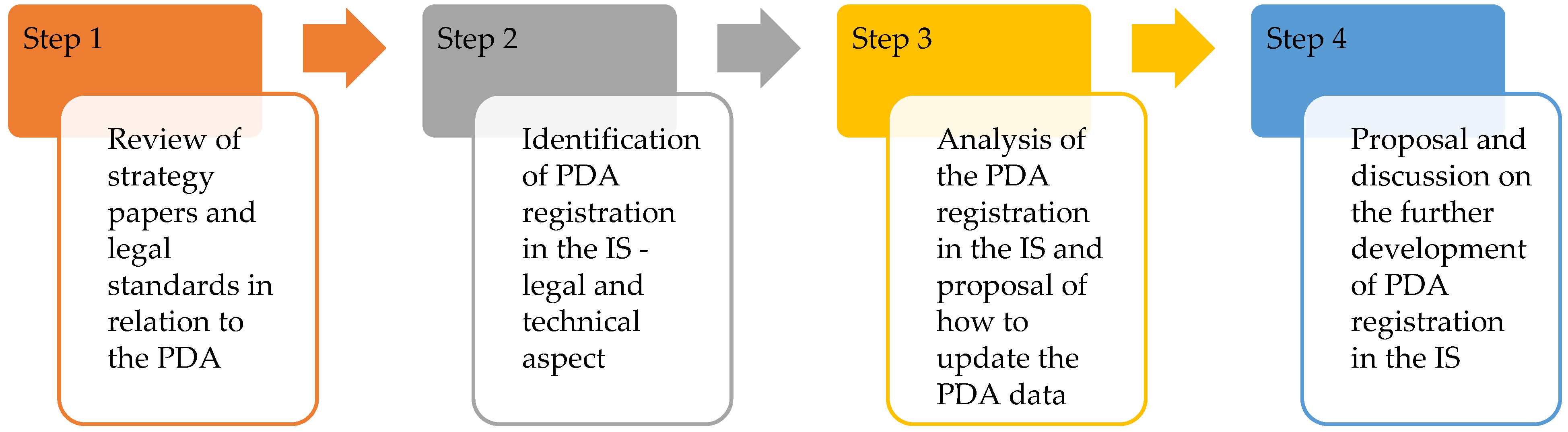
2. Materials and Methods

The research procedure was divided into 4 parts, which are shown in Figure 1. Different methods and materials were used in each phase of the research, which are described in detail in this chapter.
In the first step of the research, desk research method was used. The research included an examination of the historical background at the level of mineral resource protection, taking into account the change of the political regime after 1989 and the establishment of an independent SR in 1993. A comprehensive analysis of strategic documents issued in the framework of the implementation of the tasks set out in the national concepts and action plans of Slovakia was carried out, taking into account EU documents.
The starting point for the examination of the legal basis was the Slov-lex legal and information portal (www.slov-lex.sk, accessed on 15 July 2022), which provides access to the legislation in force in the SR and at EU level [42]. The analysis covered documents related to mineral resources and their protection. Attention was also focused on strategic documents issued at the level of the Government of the SR, the Ministry of Environment of the SR and the Ministry of Economy of the SR.
Based on the previous research results, the second step was to identify the way PDAs are recorded in public administration information systems and other records. Attention was focused on data from the Geological Information System—Geo IS (administrator of the State Geological Institute of Dionýz Štúr (SGIDŠ)), data from the database of the Main Mining Office (MMO) as the national authority of the State Mining Administration of the SR and District Mining Offices (DMO) (in the sense of the case study Košice Region (KE)). The input data include spatial and descriptive data from the information system Cadaster of Real Estate (IS CRE).
The third step involves conducting our own research into PDA record keeping (Figure 2). The starting point for the identification of PDAs was the SGIDŠ database (as of 1 January 2021), which is available through an online application [43]. SGIDŠ provides data provision through transformation and storage services in the context of the INSPIRE Directive [44].
The acquired spatial data were in the coordinate system of the Unified Trigonometric Cadastral Grid (EPSG::5513) and processed and analyzed in ArcGIS Pro 2.7.1. The vector layer in *.shp format contained 209 polygons of PDAs. The collected data were then processed with respect to the objectives of the paper. The GIS layer was compared with the data presented on the DMO web site in Košice.
In the vector layer there were two objects of PDA that were not in the list of DMO KE. These two objects were retained for further processing. Subsequently, the multiple registration of the boundary of the PDA was removed from the file.
The database of PDA of SGIDŠ is created according to individual minerals. For areas with multiple minerals, a multiple polygon is created in the database, which has the same course. After removing the duplicate occurrences of polygons, 174 areas remained in the database. For further analyses, this layer was combined with layers from the cadaster file of geodetic information (FGI) and file of descriptive information (FDI) SPI dBASE—a format for exchanging descriptive information about objects and subjects of registration in the cadaster [45]. The SPI content database was queried for the occurrence of code 401, which is used to designate a protected deposit area.
The last step involves a comprehensive evaluation of the results and knowledge obtained, taking into account the pros and cons. On the basis of the results, recommendations have been elaborated with reference to European standards (GML and XML interchange formats) also in the context of data interoperability.

3. Legal and Technical Aspects of PDA Registration

This section focuses on the basic characteristics of the historical development of PDA registration in terms of legislation as well as the technical method of registration.

3.1. History of the Mining Law

The extraction of mineral resources and the development of mining law in Slovakia are related to the establishment of the first mining settlements in the second half of the 1st century. The beginning of mining law can be considered to be the year 1035, when the right of mining (regalia) was granted by the monarch.
In the 12th century, mining of precious metals (gold and silver) took place mainly in the territory of present-day Slovakia (at that time part of Hungary). Slovak mining towns such as Banská Štiavnica, Kremnica and Gelnica were among the most important mining sites in Central Europe. After 1526, the territory of the Hungarian Crown became part of the Habsburg Monarchy, which brought further changes in mining law and order, which was influenced by the issuing of laws depending on the changing rulers.
An important chapter of the first mining records was the establishment of public mining books during the reign of Joseph II at the end of the 18th century.
At present, the mining books are stored in the Slovak Mining Archive in Banská Štiavnica. Records have been kept since the end of 15th century.
The subject of the records was not the land, but the disposition of certain minerals, namely the right to extract minerals (a separate property right).
Important legal documents related to mining law include Imperial Patent No. 146/1854 r.l. [46], which introduced a general mining law in the territory of the Austrian monarchy, including Hungary, with effect from 1 November 1854.
This patent introduced the concept of reserved mineral (specifically for coal) and thus made its extraction independent of the consent of the landowner.
In 1918, the first Czechoslovak Republic was formed by the union of the two states of the Czech Republic and Slovakia, which had until then been part of the Austro-Hungarian monarchy. The law in force at this time was the original Law No 146/1854 r.l. of the Austro-Hungarian Monarchy, which was supplemented and amended.
Fundamental changes took place only after the Second World War. A socialist system began to take shape under the laws issued at that time. The imperial patent remained in force until 1957, when a new Mining Act No 41/1957 Coll. on the exploitation of mineral wealth was passed [47]. The keeping of mining books was abolished.
Mining Act No. 41/1957 Coll. was amended several times, but its provisions described the importance of ensuring the protection of the deposit, which was determined by the so-called “executive authority of the regional national committee” according to the then regulations on spatial planning.
The method of rational use of mineral wealth and its protection was emphatically defined in the following Act No. 44/1988 Coll. on the protection and use of mineral wealth (Mining Act) [48]. This Act (amended a total of 18 times) is still one of the basic mining legislative provisions in the Slovak Republic after the division of Czechoslovakia (as of 1 January 1993).

3.2. Development after 1993 to the Present

With the establishment of the independent republics of the Slovak Republic and the Czech Republic, each of the countries, with a common legislative basis until then, sought to amend the mining legislation and, after joining the EU, to implement the issued directives and regulations.
Already in the first version of the Constitution of the Slovak Republic [49], Article 4 speaks about the ownership of the mineral wealth of the Slovak Republic.
At the level of the Government of the Slovak Republic, the document Programme Declaration of the Government [50] is elaborated, which stipulates the need to identify the net wealth of the Slovak Republic, including mineral resources.
In accordance with the above document, strategic documents are being developed at the level of individual ministries, e.g., Energy Policy of the SR, Energy Security Strategy of the SR, Update of the Raw Materials Policy [51], Concept of Geological Research and Geological Exploration of the Territory of the SR. These documents respect the objectives and strategy of the EU.
The Government of the Slovak Republic is committed to the Paris Agreement on Climate Change [52], the 2030 Agenda [53], and its 17 sustainable development goals. The primary legislation in the Slovak Republic is the Act on the Protection and Utilisation of Mineral Wealth (Mining Act) [48], which in its fourth part provides for the protection of mineral wealth by precisely defining a PDA. The basic implementing regulation of this act is the Decree of the Slovak Mining Authority on Protected Deposit Areas and Quarrying Areas [54], which provides a precise definition of the boundary of the PDA. Geological works subdivided into geological research and geological exploration are included in a separate law on geological works (Geological Law) [55].
On the basis of the amendment of the Mining Act in 2001 [56], since 2002 the mandatory protection of mineral resources in the form of registration of the boundary of the PDA in the cadaster of immovable property has been introduced.
According to §5 of the Mining Act [48], exclusive deposits are the subject of protection of the raw material potential of the Slovak Republic.
The principles for ensuring the protection of mineral resources in spatial planning activities are set out in Article 15 of the Mining Act [48]. In order to protect the exclusive against the impossibility or difficulty of its extraction, a basic category is defined, namely a PDA. The designation and changes related to the PDA are the competence of the competent DMO and are a special type of administrative procedure.
The procedure begins, in accordance with decree [54], with the submission of a proposal for the designation of the deposit area by the authorized organization to the competent DMO.
The submission must be made within 3 months of receipt of the certificate or decision on the exclusive deposit. The mandatory components of the proposal include basic information on the organization that will mine the exclusive deposit and a technical report describing the spatial (peak coordinates) and attribute components of the proposed boundaries of the PDA (PDA serial number, cadastral unit code, district code) and a list of all affected land.
The proposal also includes details of other protected areas and protection zones in the PDA and the conditions for the protection of the exclusive deposit as well as the certificate of the exclusive deposit.
The graphic annex consists of a map of the surface situation on a copy of the cadastral map or state map at a scale of 1:5000—derived and supplemented with parcel numbers and changes in the position according to the cadastral map.
The boundaries of the PDA shall be drawn on the map, as well as, if possible, a vertical projection of the outline of the exclusive deposit into this area, the boundaries of another previously designated protected deposit area or mining area.
The correctness of the graphic documents for the proposal for the delimitation of the boundary of the PDA shall be verified by a mining surveyor. The administrator or permanent user of the exclusive deposit shall proceed in a similar manner if the initiative for the designation of the PDA has been given by the state mining administration authority or another state administration authority.
If the PDA extends into the district of more than one DMO, the proposal shall be submitted to the DMO in whose district the largest portion of the PDA is located.
The competent DMO shall make a qualified decision on the designation of the PDA on the basis of the documentation submitted. The issued decision on the designation of the PDA is sent to the concerned state administration authorities, including the Ministry of the Environment of the SR and the Construction Authority. The decision is sent to the parties to the proceedings together with a certified map of the surface situation.
Under the current Building Act, the PDA boundary is an important material consideration in the planning process. The decision is also the basis for marking the boundary of the PDA in the Land Registry. The boundaries of PDAs can be changed or cancelled, and the implementation of these changes corresponds to the above-mentioned procedure.
The administrative process for PDAs by defining the protection of the resource potential is divided among several ministries (Figure 3), which have a decentralized way of managing the issuance of deeds, documentation, and registration of any spatial data.
The registration and documentation of administrative proceedings on PDA is kept by the DMOs (in Bratislava, Prievidza, Banská Bystrica, Spišská Nová Ves, Košice), which fall under the Ministry of Economy of the SR. The MMO is located in Banská Štiavnica.

3.3. Current Registration of PDAs in Slovakia

There are currently 545 PDAs registered on the territory of Slovakia (197 in the DMO Košice (as of 8 December 2021), 112 in the DMO Bratislava (as of 31 May 2021) and 235 in the DMO Banská Bystrica (as of 7 February 2022)). At the level of ministries (Figure 3), deeds in the form of documents issued (analogue method), which are the result of procedures in the process of establishing PDAs, are the subject of registration.
Spatial as well as descriptive information on PDAs is currently registered in two ISs of the SR, namely:
  • IS on geology (called Geo IS)—operated by the Ministry of Environment of the SR (administrator of the SGIDŠ)
  • IS on cadaster of real estate (referred to as IS CRE)—operated by the cadastral authority GCCA SR (administrator Institute of Geodesy and Cartography)
Both systems are part of the state IS within the meaning of the Act on Public Administration Information Systems [57].
The creation, development, and provision of information from the IS in question is carried out by administrators within the competence of the government departments.
Considering the necessity to also register PDA in the spatial planning documentation (Mining Act) [48], the registration of PDA becomes part of the municipal spatial plans. In the case of a municipality’s information system, PDA data is stored in a digital technical map as part of an established internal methodology.

3.3.1. Registration of PDAs in IS CRE

The entry of PDA into cadastral documentation in the cadaster began to be unified only after the issuance of the methodological regulation of the Directive on the registration of protected areas in the cadaster of real estate from 2017 issued by the cadastral authority of the SR. [36] The given methodology was developed due to the already adopted European legislation in an attempt to create a new approach for the protection of mineral wealth resulting from the established definition of the IS CRE.
The entry of a PDA into the cadaster is carried out on the basis of an application received by the cadaster, the content of which in the annexes section consists of:
  • The decision of the DMO on the establishment of a PDA;
  • An authorized and officially certified simplified survey sketch (to be submitted also in the case of cancellation or change of the boundary of the PDA);
  • A list of changed parcels if there have been changes in the land register between the declaration of the PDA and the submission of the application.
The competent cadastral department shall subsequently register the PDA in the cadaster of immovable property as soon as the application has been received, so that the cadastral data are not altered.
The entry of spatial information into the content of the vector cadastral map (VCM) and into the FDI within one cadastral unit (c.u.) is carried out automatically within the available applications in IS CRE at the level of the local state administration authorities in the cadastral territory. The display of spatial information on the PDA reflects the legislation, technical regulations and technical standards applicable to the creation and management of the VCM and the FDI in the IS CRE (Figure 4).
The boundary of the PDA is defined by a geometric shape with straight sides, while the vertices of the geometric shape (the refractive points of the PDA boundary) are determined in the coordinates of the S-JTSK geodetic system in the Křovák cartographic projection. The breakpoints of the boundaries of the PDA shall be obtained by measuring on a map or by direct measurement in the field.
The PDA shall be identified by the name of the relevant cadastral unit in which the PDA is located. If another PDA is defined in the same cadastral unit, the Roman numeral shall be added in systematic order.
The technical basis for the entry of spatial data into the VCM is the so-called simplified operation of the survey sketch, which is transmitted not only in analogue but also in electronic form for a particular cadaster.
While the analogue way of existence of the technical basis is already obsolete it is still necessary in the PDA process. The electronic form in the form of data interchange format contains two levels of data to be transmitted. The first is a .vgi (vector graphic interface) file and the second is a text file for updating descriptive information (for registration information PDA code 401 for each parcel inside the PDA).
The files are marked as vector geodetic basis (VGB) and are the contents of the uploaded simplified survey sketch. The file labelled VGB_1 is used to update the VCM content with the contents of the PDA boundaries in the “LINE” layer, the objects in the ‘DESCRIPTION’ layer and VGB_2 is used to update the descriptive information file with the contents of all objects (parcels) located within the PDA boundary.

3.3.2. Registration of PDAs in Geo IS

The first digital version of the PDA was created by SGIDŠ in 2002 as part of the research task [58]. The source of data were datasets with relevant maps and a database of deposits.
Currently, the entry of PDAs into Geo IS is carried out based on the decision on the designation of PDAs. In the case of a decision to change the boundary of a PDA, an update of the spatial data is carried out. Within the ArcGIS environment, a geometric representation of the PDA boundary is created based on a set of breakpoints coordinates (Figure 5a) (mining measurement documentation). The update is performed without downloading the PDA data in methodologically defined exchange formats.
The difference with the cadastral registration is in the PDA object attributes (Figure 5b), the content of which is adapted to the registration of PDA information at the level of the individual competent ministries (Figure 3). As an example of PDA data, the identical Moravany area was selected.

4. Results and Discussion

This section presents the results obtained from the analysis of IS in the context of PDA registration. It also includes a discussion on the direction of PDA registration with a view to improving data updating and linking existing IS through standardized interchange formats.

4.1. Comparison of PDAs Registration

The DMO’s areas of competence are determined by means of a decree of the Ministry of Economy of the SR. From 1996 to 2020, Decree 333/1996 Coll. [59] was in force, which determined the number of districts as 17 for the DMO in Košice. In order to rationalize and streamline the activities of DMOs and MMOs, the Ministry of Economy issued a new decree [60]. According to the decree, 25 districts with a total area of 16,992 km2, which is 35% of the total area of the SR, fall under the jurisdiction of the Košice DMO. The DMO Košice district covers 1324 c.u., of which 261 c.u. PDAs are located on 261 of them, according to SGIDŠ data.
When comparing the vector layer of PDAs from Geo IS with the “LINE” layer from the cadaster containing data on protected areas (a total of 174 PDA areas), four cases were found (Figure 6).
Of these, 72 polygons representing the PDA boundary were registered in the cadaster. Another 13 polygons were registered in the cadaster, but the course of the boundary differed from the data in the SGIDŠ vector layer. The remaining 18 areas were partially registered, and 71 PDA areas are not registered in the cadaster.
Figure 6a shows the ideal case when the boundaries of the PDA Gemerská Ves are registered in the cadaster. In spite of these areas, out of the total number of 64 analyzed owner’s folio, these areas were present in 30 of them. The other 34 title deeds did not have these areas recorded. In the case of the Gemerská Ves PDA, it is a deposit of barite, anhydrite and gypsum with the assumption that the reserves will be exploited in the future.
The Jaklovce PDA contains a high-percentage of limestone and is currently being mined. The boundary of the PDA in the SGIDŠ database (Figure 6b) has a different course than the Jaklovce PDA boundary displayed in the cadastral maps. In the third case (Figure 6c), the Gregorovce PDA is located at the boundary of two c.u. Gregorovce and Terňa. The boundary of the Gregorovce PDA is shown only on c.u. Gregorovce. The areas that the PDA attribute shows on the parcels is the content of the owner’s folio for the parcels from both c.u. The fourth case is the absence of PDA boundary courses in the cadaster. Figure 6d shows the PDA Spišské Tomášovce. The course of the PDA boundaries is not registered in the cadaster.
In the lower part of the PDA, the boundary merges with the boundary of the Slovak Paradise National Park. Similar to the previous cases, the attribute of protected areas is present on some of the owner’s folio despite the non-registration of the PDA boundary. In the part of the area where the two protected features overlap, these areas are also registered on the owner’s folio.
The analysis shows a difference in the registration of PDAs in Geo IS and IS CRE, namely in the extent of boundaries that are in accordance with the cadaster and those that are not in accordance with the cadaster. In the case of non-compliance, PDA boundaries with non-identical, incomplete, or no geometric pattern in the IS CRE versus Geo IS registration are specified. While the mining survey documentation is submitted to Geo IS for registration in the cadaster, a new elaboration certified by another surveyor is made.
These collisions can arise for various reasons, e.g., inconsistencies in the technical documents submitted for registration in the cadaster and for updating data in Geo IS (Figure 7). The time period of registration of the PDA boundaries in the cadaster also has an impact on the inconsistencies created. These result in PDA boundary data in graphical information managed in an ArcGIS or Cadastral Map Administration (CMA- license “Kokeš”) environment, which are further downloaded into public GIS layers.
While until 2016 PDA data were registered in the CRE IS without precisely specified principles, the issuance of the new directive [36] has led to the procedure according to Section 3.3.1.
In the SR, the real estate cadaster is primarily a registration tool, which serves, among other things, for the protection of mineral wealth. Only data resulting from the content of submitted documents and technical documents in the form of an application, e.g., for the registration of a restriction in rem in the form of a PDA boundary, are entered into the IS CRE. The contribution of Gałaś et. al. [16] analyses the clash in the way of recording such a substantive restriction and describes the context and procedural errors resulting currently from the complicated basis in the processes of recording protected areas in different and non-interoperable systems at the level of the state public administration within the scope of the individual ministries of the SR.
It is unprofitable in terms of administrative burden to prepare a separate elaboration by a different surveyor each time. At the same time, it is also the responsibility for the correctness of the information on the part of the mining surveyor and on the part of the authorized surveyor and cartographer, whose role for the prescribed requirements of the prepared documents is different in relation to the individual data in the databases of the solved IS. It is important to note that the validation of the validation of the currently valid exchange formats of the files with the requisites for the IS CRE is in turn confirmed by the cadastral officer.
The implementation of the proposed solution in the processes of updating and new registration concerns a case study in the locality of the c.u. of Rudňany (Spišská Nová Ves district). In the selected Rudňany locality there are deposits of barite and iron ore. The PDA is located on the territory of three c.u. Závadka, Rudňany and Poráč (Figure 8a). Active mining was carried out by underground mining, which was terminated in the 1990s. Barite mining continued until 2019 in the neighboring c.u. of Poráč.
The illustrative comparison of the recorded surface objects in Arc GIS and in the CMA clearly confirmed the inconsistency of their recording over the course of the circuit. The actual course of the PDA boundary in the SGI is not consistent with the area object recorded in the Geo IS of SGIDŠ. The geometric pattern of the PDA area that is registered in Geo IS is missing in the CRE IS, which can be seen in the detail of Figure 8b.
At the same time, the PDA code notation on some properties is absent in the IS CRE content. In the records of the c.u. Rudňany, the information on PDA is limited only to FDI in the form of the PDA code entered on the owner’s folio for the subject land on the basis of the deed, namely the decision on the registration of PDA from 1994. (“401” PDA code in the meaning of decree [61]).
According to the established areas, the analysis proceeded to quantify the number of properties within the PDA boundaries that do not have a PDA code recorded in the descriptive information (Figure 9). The PDA district extends its boundary into the built-up area as well as the rural area of the municipality.
There are a total of 1389 parcels in the built-up area, 64 of which have no indication of the existence of a PDA areas. The extra village has 431 parcels belonging to the PDA site and of these, 135 do not have a protected areas code with a PDA code of ‘401′. On the parcels where these areas are missing, this causes considerable problems, e.g., in the decision-making activities of the building authorities in cases of building permits, where this information is binding.
Elimination of such inconsistency could be eliminated only by a new procedure for correction of the cadastral data error, or by a new entry of the missing PDA code for individual parcels. All this would only be performed by a labor-intensive procedure in the form of an analogue form of submitting an application for proceedings to the cadaster.

4.2. Implementation of the Proposed Solution in the Processes of PDA Registration in IS

Since the method of data transfer at the PDA management level is difficult and unprofitable, we propose a streamlining methodology in terms of building spatial data according to GML and XML [62,63] spatial data infrastructure’s (SDI’s) standards [64,65] with the possibility to implement their introduction into the current PDA data ingestion processes in the SR by [66].
The areas presented in Section 4.1 and the decentralized management of PDA objects and their documentary evidence make for economically demanding processes that burden the state apparatus operationally and financially. The case study at the Rudňany site presented a situation that illustrated the inaccuracy of the spatial data content of the Rudňany PDA (LU-barite). The challenge was therefore to propose a solution in the form of the currently most efficient data exchange that would be both up-to-date and valid in the final IS CRE content.
As described in Section 2, the basis for the processing and creation of the content of the individual exchange formats was mainly information from Geo IS and IS CRE. According to the technical provision of the institutions responsible for the registration of PDA objects, the ArcGIS and CMA software environments were accepted, in which the spatial data content is processed and updated.
As there is no exchange of information on PDA objects between the two ISs and the data is stored only in the internal databases of both systems, according to eGovernment SR [67,68], PDA data was stored in the structure of exchange formats ending in gml and xml according to international standards [62,63] recommended for spatial data storage [69,70], accepting the recommendations of the Open Geospatial Consortium [71]. In the case of the XML file for the real estate cadaster, the prescribed national format was used.
In the first step, the SHP exchange format was created, where new attributes of the PDA area object highlighted in red were implemented, which supplement the information about the object.
In terms of the saved SHP format, the conversion to the GML interchange format was performed using the GCCA SR conversion service. The conversion also included the generation of an XSD schema (Figure 10).
Since the systems work only with the Slovak version of the labeling of attribute types in other descriptive data about PDA, these were proposed in the English version, primarily for storage in Geo IS (SHP, GML).
In 2020, a new directive on geographic information (ISO 19136-1:2020) was issued, which is also mandatory for the Slovak Republic. However, this was not implemented for all public administration IS at this time.
In order to solve this problem, from a short-term point of view, the existing version of the GML exchange format generated through the already mentioned conversion service managed by the state cadastral authority was used.
In order for the data from the GML exchange format stored in IS Geo to be transferred to IS CRE, it is necessary to define the transformations from the proposed concepts of the internal schema to the concept of the application schema in the future, and then use appropriate software to transform the data about the PDA object with the transfer of information about its existence to the data cadastral parcels (code PDA = 401).
Considering the currently preferred and evolving XML file content for updating data in cadastral files, we proposed a new XML file structure for updating PDA object data (Figure 11).
The proposed XML file reflects basic and extended attributes from SHP and GML files stored in Geo IS. Since the cadastral registration of a PDA object has a procedural procedure established by legislation, this is fully accepted and with this proposal moved to a higher technical level of data exchange, in electronic form.
Thus, the implementation of a less economically demanding procedure using a single exchange format for faster updating of PDA objects in IS CRE with an associated security feature such as the advanced electronic signature (XAdES) of the competent person responsible for its content [72,73], which does not exist in the current uploaded XML files, has been presented.
This provides basic authentication and integrity protection and meets the legal requirements for advanced electronic signatures defined in the European Directive [74,75]. Of course, the content verification is done in order to reduce errors in terms of a well-defined XSD structure at the level of the responsible government departments.
In order to make the storage of spatial data more efficient, an XML data interchange format with a structure that corresponds to the internal regulations of selected ministries in the field of cadaster and agricultural land protection [76] was produced as a result. Validation of the file [77] and reading of the content of the XML thus created is proposed to be further carried out by means of an intra-ministerial application for the subsequent updating of cadastral data in the given c.u.
The unique indentifier (ID) represents in the XML file the key characteristic of the object registered in the individual IS. The created XML file structure corresponds to the data currently in the update files VGB_1 and VGB_2 mentioned in Section 3.3.1. The XML contains selected new elements that have been named in English. In the future, consideration should be given to the introduction of English naming of the individual code lists. In order not to disrupt the continuity of the existing codebooks in the CN IS, these have been maintained. The file thus created can be used by the competent mining authority for the immediate electronic exchange of data to the IS CRE.

4.3. The Future of PDA Registration

As an example of a different approach to the registration of PDAs, we can present the example of the Czech Republic. After the division of Czechoslovakia and the establishment of the independent states of the Czech Republic and Slovakia in 1993, the development in the field of PDA registration in each of them began to take a different course. Currently, the Czech Republic has a new Act No 88/2021 Coll. [78], which replaced the original common Act No. 44/1988 Sb. [48]
This new law of 2021 [78] clearly defines the raw material policy of the state and the way of recording and the content of PDA data in the Registry of Territorial Identification, Addresses and Real Estate (RTIARE) of the public administration recorded under the so-called special purpose territorial elements. The provisions of the law are gradually being applied to the forthcoming technical environments of the IS VS. The Ministry of the Environment of the Czech Republic is obliged to enter data on the protected deposit area into RTIARE no later than 12 months after the entry into force of the act. Once the data has been entered, the Czech Office for Surveying, Mapping and Cadaster will ensure that checks are carried out and discrepancies between the PDA data in RTIARE and the data held in ISCRE are resolved within 17 months (after the act enters into force).
At the same time, within the public administration, the Czech Republic is successfully promoting the linking of the activities of the state mining administration with the construction authorities and the harmonization in the data content of the databases of the gradually expanding environment in the IS of the public administration.
According to the development set by the new concepts of standardization in the issued international standards and the management of data recommended by them, it predetermines a well-defined path, which has a priority basis in the legal regulation of laws, technical, and organizational concepts of the individual countries it relates to [79].
Works [80,81,82,83,84,85] address the issue of the need to register underground objects in the content of 3D geographic systems, but the extent of the legal space in the form of law restriction is not addressed. PDA in the case of mining works not excluding.
Our paper highlights the need to register underground objects and PLRs that affect property rights to real estate already registered in a 2D cadaster.
The work of Višnjevac et.al. [86] points out the importance of dealing with the ways of storing spatial data in 3D land registries. The basis is authoritative and mandatory information from 2D cadaster, which is based on licensed technical documents downloaded from other information systems at the level of government departments and organizations. Their responsibility for the provided data, the content of which is downloaded into cadaster databases, is a priority task for state-guaranteed information [87,88].
Slovakia is a country with a rich history of raw material extraction and therefore it is necessary to pay increased attention to mining objects that are no longer in operation and physically exist. This means gradually expanding the register not only to include new protected realities but also PDAs within old mining works. Figure 12 shows an example of 3D PLR modelling in the scope of 3D PDAs affecting surface objects (land parcels and buildings) and underground physical objects (old mine workings) in the studied area of the municipality Rudňany.
The PDA object has been determined in 2D as it is currently absent in the cadaster and its representation in 3D is a vision of future three-dimensional information systems, while a more detailed determination of the space above and below the ground surface must be defined by supplementing the legislative regulations.
The registration of underground objects and property constraints in the context of the Czech Republic and Slovakia with the possibility of using the recommendations of the ISO 19152 Land Administration Domain Model standard is dealt with in the works of Janečka and Bobikova [89,90]. The proposal of PDA registration in 3D cadaster follows in its significance precisely the research carried out in these works.

5. Conclusions

Environmental protection in relation to the protection of mineral deposits must be achievable taking into account the constraints on the provision of strategic raw materials. Within the EU, an important task is to ensure energy security in terms of increased use of both renewable resources and strategic raw materials. In the context of events in Europe, there is a need for reliable information on mineral resources in terms of their location in a specific territory, in order to be able to analyze the state of mineral resources and the prospect of their re-use for the energy stabilization of EU countries.
The results of the research confirmed the decentralization of PDA registration and the inconsistent way of updating the data, which are in the competence of different state departments and organizations managing IS in specifically selected locations in the territory of the SR. At present, there is no concrete example in the way of updating data on PDAs in the form of a methodology for exchanging reliable electronic data on them and it is obvious that the shortcomings are due to the human factor.
Regarding the trustworthiness of the PDA data records, the most-used data content is the PDA object data in the IS CRE registry. The results of the analysis showed inconsistencies with the registration of PDA objects. From a historical point of view, this is the result of the non-recording of PDAs, which until 2015 were only the subject of DMO registration, or were only kept in Geo IS. Currently, it is not possible to retroactively update the content of PDA boundaries that have not been included in the IS CRE.
The proposed methodology presents a procedure in terms of recommended standardized exchange formats, which guarantees not only the entry of the PDA in the form of a PDA code on the respective parcels but also reliable spatial information with the qualitative content of the area object, a unique identifier and a qualified signature of the responsible person—the contractor.
In order to improve the quality of data and to support the principle of interoperability, the article elaborates a methodology that supports the exchange of information between selected IS of public administration of the Slovak Republic and tries to comply with the preferred principle, one time and enough. The methodology refers to the streamlining of the transmitted data, which are also of utmost importance from the point of view of the decision-making activities of the individual departments involved and ultimately provide reliable information at the level of priority objectives in the sense of the National Concept of Informatization of Public Administration of the SR [91]. The research and development of IS also at the level of 3D GIS indicates the importance of record-keeping so that in the next steps of IS development it is possible to implement the third dimension on the basis of the existing 2D registration.
In other contexts, it is appropriate to pay more attention in the future to nationally defined PDAs, which are also subject to registration at national borders. Their designation is subject to further legislation that takes account of national interests in the form of international treaties and agreements which further define the conditions in the event of mineral extraction.

Author Contributions

Conceptualization, Z.K., S.K., I.A. and D.B.; methodology Z.K. and D.B.; software, Z.K.; validation, Z.K. and S.K.; formal analysis, Z.K., S.K. and D.B.; investigation, D.B.; resources Z.K.; data curation, Z.K., S.K. and D.B.; writing—original draft preparation, Z.K., S.K., I.A. and D.B.; writing—review and editing, S.K.; visualization, Z.K., S.K., I.A. and D.B.; supervision, S.K. All authors have read and agreed to the published version of the manuscript.

Funding

This research was funded by Scientific grant agency of Ministry of Education, science, research and sport of the Slovak Republic, grant number VEGA 1/0797/20.

Institutional Review Board Statement

Not applicable.

Informed Consent Statement

Not applicable.

Data Availability Statement

The data used in this study are publicly through Geoportal Available online: https://www.geoportal.sk/en/ (accessed on 16 May 2022), and Geofond Registries—Deposits Available online: https://apl.geology.sk/clip/?dataset=8&coord_sys=5514 (accessed on 20 May 2022).

Acknowledgments

Thanks to data owner Geodesy, Cartography and Cadaster Authority of the Slovak Republic (ÚGKK SR) and State Geological Institute of Dionýz Štúr.

Conflicts of Interest

The authors declare no conflict of interest.

References

  1. Lusty, P.A.J.; Gunn, A.G. Challenges to global mineral resource security and options for future supply. Geol. Soc. Spec. Publ. 2014, 393, 265–276. [Google Scholar] [CrossRef] [Green Version]
  2. Nurmi, P.A. Green mining—A holistic concept for sustainable and acceptable mineral production. Ann. Geophys. 2017, 60, 1–7. [Google Scholar] [CrossRef] [Green Version]
  3. Xu, R.; Chen, X.; Zhang, F. Green technology innovation and sustainable development based on data fusion mining. Ekoloji 2019, 28, 1825–1833. [Google Scholar]
  4. Huang, J.; Guo, D.; Hou, H. An Analysis of Progress and Models of Local Green Mining. In Proceedings of the IOP Conference Series: Earth and Environmental Science, Changchun, China, 21–23 August 2020; Volume 558, p. 022022. [Google Scholar]
  5. Hund, K.; LaPorta, D.; Fabregas, T.; Laing, T.; Drexhage, J. Minerals for Climate Action: The Mineral Intensity of the Clean Energy Transition; The World Bank Group, Climate-Smart Mining Initiative: Washington, DC, USA, 2020. [Google Scholar]
  6. European Commission. Directorate-General for Internal Market, Industry, Entrepreneurship and SMEs. EU Principles for Sustainable Raw Materials; Luxembourgh, Publications Office of the European Union: 2021. Available online: https://data.europa.eu/doi/10.2873/27875 (accessed on 1 July 2022).
  7. Ali, S.H.; Giurco, D.; Arndt, N.; Nickless, E.; Brown, G.; Demetriades, A.; Durrheim, R.; Enriquez, M.A.; Kinnaird, J.; Littleboy, A.; et al. Mineral supply for sustainable development requires resource governance. Nature 2017, 543, 367–372. [Google Scholar] [CrossRef] [Green Version]
  8. Kurniawan, N.I.; Lujala, P.; Rye, S.A.; Vela-Almeida, D. The role of local participation in the governance of natural resource extraction. Extr. Ind. Soc. 2022, 9, 101029. [Google Scholar] [CrossRef]
  9. Milligan, B.; O’Keeffe, M. Global Governance of Resources and Implications for Resource Efficiency in Europe. Ecol. Econ. 2019, 155, 46–58. [Google Scholar] [CrossRef]
  10. Christmann, P. Mineral Resource Governance in the 21st Century and a sustainable European Union. Miner. Econ. 2021, 34, 187–208. [Google Scholar] [CrossRef]
  11. Janikowska, O.; Kulczycka, J. Impact of minerals policy on sustainable development of mining sector—A comparative assessment of selected EU countries. Miner. Econ. 2021, 34, 305–314. [Google Scholar] [CrossRef]
  12. Nieć, M.; Radwanek-Bąk, B.; Koźma, J.; Kozłowska, O. Polish approach to the mineral deposits safeguarding. Experience and problems. Resour. Policy 2022, 75, 102460. [Google Scholar] [CrossRef]
  13. Nikitina, N. Mineral resource dilemma: How to balance the interests of Government, local communities and abiotic nature. Int. J. Environ. Res. Public Health 2014, 11, 8632–8644. [Google Scholar] [CrossRef] [Green Version]
  14. Rudke, A.P.; Sikora de Souza, V.A.; dos Santos, A.M.; Freitas Xavier, A.C.; Rotunno Filho, O.C.; Martins, J.A. Impact of mining activities on areas of environmental protection in the southwest of the Amazon: A GIS- and remote sensing-based assessment. J. Environ. Manag. 2020, 263, 110392. [Google Scholar] [CrossRef] [PubMed]
  15. Gałaś, S. Assessment of implementation of protection of mineral deposits in spatial planning in Poland. Land Use Policy 2017, 67, 584–596. [Google Scholar] [CrossRef]
  16. Gałaś, S.; Kot-Niewiadomska, A.; Gałaś, A.; Kondela, J.; Wertichovà, B. Instruments of mineral deposit safeguarding in Poland, Slovakia and Czechia-comparative analysis. Resources 2021, 10, 16. [Google Scholar] [CrossRef]
  17. Sivek, M.; Kavina, P.; Jirásek, J. New mineral policy of the Czech Republic of June 2017. Resour. Policy 2019, 60, 246–254. [Google Scholar] [CrossRef]
  18. Wårell, L. Mineral deposits safeguarding and land use planning—The importance of creating shared value. Resources 2021, 10, 33. [Google Scholar] [CrossRef]
  19. Gao, Y.; Wang, J.; Zhang, M.; Li, S. Measurement and prediction of land use conflict in an opencast mining area. Resour. Policy 2021, 71, 101999. [Google Scholar] [CrossRef]
  20. Wrighton, C.E.; Bee, E.J.; Mankelow, J.M. The development and implementation of mineral safeguarding policies at national and local levels in the United Kingdom. Resour. Policy 2014, 41, 160–170. [Google Scholar] [CrossRef] [Green Version]
  21. Górniak-Zimroz, J.; Pactwa, K. The Use of Spatial Data in Granite Deposit Life Cycle Assessment. Procedia Earth Planet. Sci. 2015, 15, 474–481. [Google Scholar] [CrossRef] [Green Version]
  22. Mattig, U. Maps of the natural environment’s potential in West Germany and Norway as an aid for mineral resources management and protection. Eng. Geol. 1990, 29, 321–331. [Google Scholar] [CrossRef]
  23. Yousefi, M.; Carranza, E.J.M.; Kreuzer, O.P.; Nykänen, V.; Hronsky, J.M.A.; Mihalasky, M.J. Data analysis methods for prospectivity modelling as applied to mineral exploration targeting: State-of-the-art and outlook. J. Geochem. Explor. 2021, 229, 106839. [Google Scholar] [CrossRef]
  24. Carvalho, J.; Galos, K.; Kot-Niewiadomska, A.; Gugerell, K.; Raaness, A.; Lisboa, V. A look at European practices for identifying mineral resources that deserve to be safeguarded in land-use planning. Resour. Policy 2021, 74, 102248. [Google Scholar] [CrossRef]
  25. Kivinen, M.; Eilu, P.; Markovaara-Koivisto, M. Mineral futures in land-use planning: Foresight tools and case studies in Northern Finland. Resour. Policy 2021, 70, 101917. [Google Scholar] [CrossRef]
  26. Radwanek-Bąk, B.; Kivinen, M. Legal and formal factors related to the mineral raw material deposits accessibility in Europe. Gospod. Surowcami Miner. 2016, 32, 59–72. [Google Scholar] [CrossRef] [Green Version]
  27. Rowland, A.; Folmer, E.; Beek, W.; Wenneker, R. Interoperability and Integration: An Updated Approach to Linked Data Publication at the Dutch Land Registry. ISPRS Int. J. Geo-Inf. 2022, 11, 51. [Google Scholar] [CrossRef]
  28. Aydinoglu, A.C.; Bovkir, R. Generic land registry and cadastre data model supporting interoperability based on international standards for Turkey. Land Use Policy 2017, 68, 59–71. [Google Scholar] [CrossRef]
  29. Dawidowicz, A.; Kulawiak, M.; Zysk, E.; Kocur-Bera, K. System architecture of an INSPIRE-compliant green cadastre system for the EU Member State of Poland. Remote Sens. Appl. Soc. Environ. 2020, 20, 100362. [Google Scholar] [CrossRef]
  30. Hadzilakos, T.; Halaris, G.; Kavouras, M.; Kokla, M.; Panopoulos, G.; Paraschakis, I.; Sellis, T.; Tsoulos, L.; Zervakis, M. Interoperability and definition of a national standard for geospatial data: The case of the Hellenic Cadastre. Int. J. Appl. Earth Obs. Geoinf. 2000, 2, 120–128. [Google Scholar] [CrossRef]
  31. Kitsakis, D.; Kalogianni, E.; Dimopoulou, E. Public Law Restrictions in the Context of 3D Land Administration—Review on Legal and Technical Approaches. Land 2022, 11, 88. [Google Scholar] [CrossRef]
  32. Kitsakis, D.; Kalantari, M.; Rajabifard, A.; Atazadeh, B.; Dimopoulou, E. Exploring the 3rd dimension within public law restrictions: A case study of Victoria, Australia. Land Use Policy 2019, 85, 195–206. [Google Scholar] [CrossRef]
  33. Kitsakis, D.; Dimopoulou, E. Possibilities of Integrating Public Law Restrictions to 3D Cadastres. In Proceedings of the 5th International FIG 3D Cadastre Workshop, Athens, Greece, 18–20 October 2016; pp. 25–46. [Google Scholar]
  34. Aydin, C.; Demir, O.; Atasoy, M. Third Dimension (3D) in Cadastre and Its Integration with 3D GIS in Turkey. In Proceedings of the FIG Working Week 2004, Athens, Greece, 22–27 May 2004; pp. 1–15. [Google Scholar]
  35. Cadastre and Land Registry Knowledge Exchange Network. Documentation of “Public—Law Restrictions”; Eurogeographics: Brussels, Belgium, 2015. [Google Scholar]
  36. UGKK. Smernica na Evidovanie Chránených Skutočností v Katastri Nehnuteľností. 2016. Available online: https://www.skgeodesy.sk/files/sk/slovensky/ugkk/kataster-nehnutelnosti/technicke-predpisy-ine-akty-riadenia/sm_ugkk-sr_20_2016.pdf (accessed on 15 June 2022).
  37. Paasch, J.M.; Paulsson, J. 3D property research from a legal perspective revisited. Land 2021, 10, 494. [Google Scholar] [CrossRef]
  38. Abcede, R.; Gera, W. Examining the coherence of legal frameworks for ecosystem services toward sustainable mineral development in the Association of Southeast Asian Nations. Ecosyst. Serv. 2018, 29, 228–239. [Google Scholar] [CrossRef]
  39. Chang, Y.C.; Wang, C.; Khan, M.I.; Wang, N. The legal system for environmental protection during exploration and exploitation of marine mineral resources in China. Resour. Policy 2020, 67, 101670. [Google Scholar] [CrossRef]
  40. Murzydlo, J. Prawo iadministracja geologiczna: Ochrona zloz kopalin-wybrane zagadnienia. Prz. Geol. 2020, 68, 861–868. [Google Scholar]
  41. Bednárová, L.; Džuková, J.; Grosoš, R.; Gomory, M.; Petráš, M. Legislative instruments and their use in the management of raw materials in the Slovak Republic. Acta Montan. Slovaca 2020, 25, 105–115. [Google Scholar] [CrossRef]
  42. 400/2015 Z. z. Zákon o Tvorbe Právnych Predpisov a o Zbierke Zákonov Slovenskej Republiky a o Zmene a Doplnení Niektorých Zákonov. Available online: https://www.slov-lex.sk/pravne-predpisy/SK/ZZ/2015/400/20210101 (accessed on 10 June 2022).
  43. Ložiská SR—Register Geofondu. Available online: https://apl.geology.sk/geofond/loziska2/ (accessed on 10 April 2022).
  44. European Parliament; Council of the European Union. Directive 2007/2/EC of the European Parliament and of the Council of 14 March 2007 Establishing an Infrastructure for Spatial Information in the European Community (INSPIRE); Publications Office of the European Union: Luxembourg, 2007; p. 14. Available online: http://data.europa.eu/eli/dir/2007/2/2019-06-26 (accessed on 4 February 2022).
  45. GKU. Štruktúra Súborov Popisných Informácii Katastra Nehnuteľností. Available online: https://www.geoportal.sk/files/kn/struktura_udajov_spi.pdf (accessed on 4 April 2022).
  46. Cisársky Patent č. 146/1854 r.z. Obecný Horní Zákon (ve Znění Předpisů jej Měnících a Doplňujících ke dni 1. 1. 1930). Available online: https://www.epravo.cz/vyhledavani-aspi/?Id=27&Section=1&IdPara=1&ParaC=2 (accessed on 10 May 2022).
  47. 41/1957 Zb. Zákon o Využití Nerastného Bohatstva (Banský Zákon). Available online: https://www.slov-lex.sk/pravne-predpisy/SK/ZZ/1957/41/19580101.html (accessed on 2 May 2022).
  48. 44/1988 Zb. Zákon o Ochrane a Využití Nerastného Bohatstva (Banský Zákon). Available online: https://www.slov-lex.sk/pravne-predpisy/SK/ZZ/1988/44/ (accessed on 2 May 2022).
  49. 460/1992 Zb. Ústava Slovenskej Republiky. Available online: https://www.slov-lex.sk/pravne-predpisy/SK/ZZ/1992/460/19921001.html (accessed on 3 May 2022).
  50. Programové Vyhlásenie Vlády Slovenskej Republiky. Available online: https://www.nrsr.sk/web/Dynamic/DocumentPreview.aspx?DocID=494677 (accessed on 10 April 2022).
  51. Aktualizácia Surovinovej Politiky. Available online: https://www.mhsr.sk/energetika/surovinova-politika/aktualizacia-surovinovej-politiky (accessed on 15 April 2022).
  52. United Nations Framework Convention on Climate Change (UNFCCC). The Paris Agreement. Available online: http://unfccc.int/paris_agreement/items/9485.php (accessed on 18 May 2022).
  53. United Nations. Transforming Our World: The 2030 Agenda for Sustainable Development. 2015. Available online: https://www.sustainabledevelopment.un.org (accessed on 12 May 2022).
  54. 79/1988 Zb. Vyhláška Slovenského Banského Úradu o Chránených Ložiskových Územiach a Dobývacích Priestoroch. Available online: https://www.slov-lex.sk/pravne-predpisy/SK/ZZ/1988/79/ (accessed on 12 May 2022).
  55. 569/2007 Z. z. Zákon o o Geologických Prácach (Geologický Zákon). Available online: https://www.slov-lex.sk/pravne-predpisy/SK/ZZ/2007/569/20220101 (accessed on 12 May 2022).
  56. 558/2001 Z. z. Zákon Ktorým sa Mení a Dopĺňa Zákon č. 44/1988 Zb. o Ochrane a Využití Nerastného Bohatstva (Banský Zákon) v Znení Zákona Slovenskej Národnej Rady č. 498/1991 Zb. Available online: https://www.slov-lex.sk/pravne-predpisy/SK/ZZ/2001/558/20020101.html (accessed on 12 May 2022).
  57. 95/2019 Z. z. Zákon o Informačných Technológiách vo Verejnej Správe a o Zmene a Doplnení Niektorých Zákonov. Available online: https://www.slov-lex.sk/pravne-predpisy/SK/ZZ/2019/95/20211105 (accessed on 18 May 2022).
  58. Kúšik, D.; Lamoš, A. Vzťah horninového prostredia ku ochrane prírody a krajiny. Záverečná Správa, Ministerstvo životného prostredia Slovenskej republiky, ŠGUDŠ. Bratislava. 2002. Available online: https://da.geology.sk/navigator/?desktop=PublicAnonym (accessed on 20 May 2022).
  59. 333/1996 Z. z. Vyhláška Ministerstva Hospodárstva Slovenskej Republiky, Ktorou sa Ustanovujú Obvody Pôsobnosti Obvodných Banských Úradov. Available online: https://www.slov-lex.sk/pravne-predpisy/SK/ZZ/1996/333/19961201.html (accessed on 18 May 2022).
  60. 146/2020 Z. z. Vyhláška Ministerstva Hospodárstva Slovenskej Republiky, Ktorou sa Ustanovujú Obvody Pôsobnosti Obvodných Banských Úradov. Available online: https://www.slov-lex.sk/pravne-predpisy/SK/ZZ/2020/146/20201115 (accessed on 18 May 2022).
  61. 61/2009 Z. z.Vyhláška Úradu Geodézie, Kartografie a Katastra Slovenskej Republiky, Ktorou sa Vykonáva Zákon Národnej rady Slovenskej Republiky č. 162/1995 Z. z. o Katastri Nehnuteľností a o Zápise Vlastníckych a Iných Práv k Nehnuteľnostiam (Katastrálny Zákon) v Znení Neskorších Predpisov. Available online: https://www.slov-lex.sk/pravne-predpisy/SK/ZZ/2009/461/20181001 (accessed on 18 May 2022).
  62. OGC. Geography Markup Language. Available online: https://www.ogc.org/standards/gml (accessed on 25 May 2022).
  63. W3C XML Schema Definition Language (XSD) 1.1. Available online: https://www.w3.org/TR/xmlschema11-1/ (accessed on 25 May 2022).
  64. Chojka, A. Considerations about the quality of UML and GML application schemas. Rep. Geod. Geoinform. 2020, 109, 17–23. [Google Scholar] [CrossRef]
  65. Kotsev, A.; Minghini, M.; Tomas, R.; Cetl, V.; Lutz, M. From spatial data infrastructures to data spaces—A technological perspective on the evolution of European SDIs. ISPRS Int. J. Geo-Inf. 2020, 9, 176. [Google Scholar] [CrossRef] [Green Version]
  66. INSPIRE. Data Specifications. Available online: https://inspire.ec.europa.eu/document-tags/data-specifications (accessed on 18 May 2022).
  67. 305/2013 Z. z. Zákon o o Elektronickej Podobe Výkonu Pôsobnosti Orgánov Verejnej Moci a o Zmene a Doplnení Niektorých Zákonov (Zákon o e-Governmente). Available online: https://www.slov-lex.sk/pravne-predpisy/SK/ZZ/2013/305/20201230 (accessed on 18 May 2022).
  68. 575/2001 Z. z. o organizácii činnosti vlády a organizácii ústrednej štátnej správy (kompetenčný zákon) v znení neskorších predpisov. Available online: https://www.slov-lex.sk/pravne-predpisy/SK/ZZ/2001/575/20220425.html (accessed on 18 May 2022).
  69. Portele, C. Encoding of Geographic Information. In Springer Handbook of Geographic Information; Springer: Cham, Switzerland, 2022; ISBN 978-3-030-53125-6. [Google Scholar] [CrossRef]
  70. Mora-Navarro, G.; Femenia-Ribera, C.; Velilla Torres, J.M.; Martinez-Llario, J. Geographical Data and Metadata on Land Administration in Spain. Land 2022, 11, 1107. [Google Scholar] [CrossRef]
  71. OGC. Observations and Measurements. Available online: https://www.ogc.org/Standards/Om (accessed on 25 May 2022).
  72. ETSI. ETSI TS 101 903 V1.4.1 (2009-06) XML Advanced Electronic Signatures (XAdES). Technical Specification; ETSI: Sophia Antipolis CEDEX, Vallauris, France, 2009. [Google Scholar]
  73. W3C XML Advanced Electronic Signatures (XAdES). Available online: https://www.w3.org/TR/XAdES/ (accessed on 25 May 2022).
  74. Regulation (EU) No 910/2014 of the European Parliament and of the Council of 23 July 2014 on Electronic Identification and Trust Services for Electronic Transactions in the Internal Market and Repealing Directive 1999/93/EC. Available online: http://data.europa.eu/eli/reg/2014/910/oj (accessed on 25 May 2022).
  75. Commission Implementing Regulation (EU) 2015/1502 of 8 September 2015 on Setting out Minimum Technical Specifications and Procedures for Assurance Levels for Electronic Identification Means Pursuant to Article 8(3) of Regulation (EU) No 910/2014 of the European Parliament and of the Council on Electronic Identification and Trust Services for Electronic Transactions in the Internal Market. Available online: http://data.europa.eu/eli/reg_impl/2015/1502/oj (accessed on 25 May 2022).
  76. ÚGKK SR a MPRV SR. Dočasný Metodický Návod-Vykonávanie Geodetických Činností Pre Projekt Pozemkových Úprav v Rámci Operátu Obvodu. Available online: https://mpsr.sk/docasny-metodicky-navod-ugkk-sr-a-mprv-sr-vykonavanie-geodetickych-cinnosti-pre-projekt-pozemkovych-uprav-v-ramci-operatu-obvodu/59---16354/ (accessed on 25 May 2022).
  77. UGKK SR.Usmernenie, Ktorým sa Ustanovujú Elektronické Podklady na Aktualizáciu Súboru Popisných Informácií. Available online: http://www.skgeodesy.sk/files/sk/slovensky/ugkk/kataster-nehnutelnosti/technicke-predpisy-ine-akty-riadenia/usm_ugkk-sr_11_2013.pdf (accessed on 28 May 2022).
  78. 88/2021 Sb. Zákon, Kterým se Mění Zákon č. 44/1988 Sb., o Ochraně a Využití Nerostného Bohatství (Horní Zákon), ve Znění Pozdějších Předpisů, a Další Související Zákony. Available online: https://www.zakonyprolidi.cz/cs/2021-88 (accessed on 28 May 2022).
  79. Regulation of the European Parliament and of The Council on European data governance (Data Governance Act). Available online: https://eur-lex.europa.eu/legal-content/EN/TXT/?uri=CELEX:52020PC0767 (accessed on 25 May 2022).
  80. Saeidian, B.; Rajabifard, A.; Atazadeh, B.; Kalantari, M. Underground land administration from 2d to 3d: Critical challenges and future research directions. Land 2021, 10, 1101. [Google Scholar] [CrossRef]
  81. Bieda, A.; Bydłosz, J.; Warchoł, A.; Balawejder, M. Historical Underground Structures as 3D Cadastral Objects. Remote Sens. 2020, 12, 1547. [Google Scholar] [CrossRef]
  82. Kim, S.; Heo, J. Registration of 3D underground parcel in Korean cadastral system. Cities 2019, 89, 105–119. [Google Scholar] [CrossRef]
  83. Duncan, E.E.; Abdul Rahman, A. 3D GIS for mine development—Integrated concepts. Int. J. Mining Reclam. Environ. 2015, 29, 3–18. [Google Scholar] [CrossRef]
  84. Sharafat, A.; Khan, M.S.; Latif, K.; Tanoli, W.A.; Park, W.; Seo, J. Bim-gis-based integrated framework for underground utility management system for earthwork operations. Appl. Sci. 2021, 11, 5721. [Google Scholar] [CrossRef]
  85. Wang, M.; Deng, Y.; Won, J.; Cheng, J.C.P. An integrated underground utility management and decision support based on BIM and GIS. Autom. Constr. 2019, 107, 102931. [Google Scholar] [CrossRef]
  86. Višnjevac, N.; Mihajlović, R.; Šoškić, M.; Cvijetinović, Ž.; Bajat, B. Prototype of the 3D Cadastral System Based on a NoSQL Database and a JavaScript Visualization Application. ISPRS Int. J. Geo-Inf. 2019, 8, 227. [Google Scholar] [CrossRef]
  87. 362/2015 Z.z. Zákon o Ktorým Sa Mení a Dopĺňa Zákon č. 3/2010 Z. z. o Národnej Infraštruktúre Pre Priestorové Informácie. Available online: https://www.slov-lex.sk/pravne-predpisy/SK/ZZ/2015/362/20160501 (accessed on 21 May 2022).
  88. 12/2017 Z. z. Vyhláška Ministerstva Životného Prostredia Slovenskej Republiky Ktorou sa Mení a Dopĺňa Vyhláška Ministerstva Životného prostredia Slovenskej Republiky č. 352/2011 Z. z., Ktorou sa Vykonávajú Niektoré Ustanovenia Zákona č. 3/2010 Z. z. o Národnej Infraštruktúre pre Priestorové Informácie. Available online: https://www.slov-lex.sk/pravne-predpisy/SK/ZZ/2017/12/20170201 (accessed on 28 May 2022).
  89. Janečka, K.; Bobíková, D. Registering the underground objects in the 3D cadastre: A case study of wine cellar located in the vineyard area Tokaj. Acta Montan. Slovaca 2018, 23, 260–270. [Google Scholar]
  90. Bobikova, D. Riešenie, Spracovanie a Aktualizácia Operátu Katastra Nehnuteľností v 3D Katastri. Dizertačná práca 146 p. Technická univerzita v Košiciach. 2019. Available online: https://opac.crzp.sk/?fn=detailBiblioForm&sid=1207FF88EADD70B1DCC7AB0BD7FD (accessed on 11 May 2022).
  91. MIRRI Národná Koncepcia Informatizácie Verejnej Správy Slovenskej Republiky. Available online: https://www.mirri.gov.sk/wp-content/uploads/2021/12/Narodna-koncepcia-informatizacie-verejnej-spravy-2021.pdf (accessed on 28 May 2022).
Figure 1. The methodology flowchart.
Land 11 02013 g001
Figure 2. Processing data within the PDA data registration.
Land 11 02013 g002
Figure 3. Management and registration of PDA documents is the responsibility of the ministries of the SR.
Land 11 02013 g003
Figure 4. Example of geometric and attribute representation of the boundary of the PDA c.u. Moravany.
Land 11 02013 g004
Figure 5. Representation of the method of recording PDA from Geo IS in the GIS environment: (a) breakpoint coordinates; (b) attribute table.
Land 11 02013 g005
Figure 6. Cases of comparison of PDA registration data: (a) PDA is registered in both systems; (b) non-identical PDA boundary; (c) registration of PDA at the boundary of two c.u.; (d) missing PDA boundary in the cadaster.
Land 11 02013 g006
Figure 7. Illustration of the way to submit PDA data for updating.
Land 11 02013 g007
Figure 8. Protected deposit area Rudňany: (a) PDA boundary within three cadastral units; (b) Detail of the representation of the inconsistency of the registered PDA boundary.
Land 11 02013 g008
Figure 9. Graphical representation of “401” PDA code information on parcels in the c.u. Rudňany.
Land 11 02013 g009
Figure 10. Example of extended shapefile content to GML file content.
Land 11 02013 g010
Figure 11. Representation of the proposed XML file with associated content for future update in the CRE IS.
Land 11 02013 g011
Figure 12. 3D model of the PDA object in c.u. Rudňany.
Land 11 02013 g012
Publisher’s Note: MDPI stays neutral with regard to jurisdictional claims in published maps and institutional affiliations.

