Article

Beijing’s First Green Belt—A 50-Year Long Chinese Planning Story

Department of Geosciences and Natural Resource Management, University of Copenhagen, 2000 Frederiksberg, Denmark
*
Author to whom correspondence should be addressed.
Land 2021, 10(9), 969; https://doi.org/10.3390/land10090969
Submission received: 2 July 2021 / Revised: 10 September 2021 / Accepted: 11 September 2021 / Published: 15 September 2021

Abstract

:
This article traces the development process of Beijing’s First Green Belt from its origins in the 1950s, to its reinterpretation in the 1980s/1990s and its implementation in the 1990s/2000s. We identify three-time phases and important milestones, which kept the green belt idea alive, developed it and contextualized it in relation to the historical background. This article shows that the first green belt project in Beijing was a continuing process of changing functions and ranges. Its adaptability to variations followed the political changes and reflected the socio-economic dynamics, which secured its longevity. Different ideas shaped the plan and its link to mega events like the Olympic Games and environmental problems accelerated the implementation, but the shortage of funding and absence of legislation led to a compromised result. The case is an interesting example of how a long-term project transforms over and with time, but also for the gap between planning ambitions and actual urban development, illustrating past and contemporary urban planning in the context of a fast-developing country.

1. Introduction

1.1. Planning for the Rapid Growth of Beijing

Beijing has experienced a tremendous urban growth in the past century, growing from 4.2 million inhabitants in 1949 to 21.7 million inhabitants in 2015. In parallel with that, the built-up area of the city expanded and increased its size by more than 12 times in that period, from 109 to 1401 km2 [1]. Regulating urban development of the capital was always a major focus of planning and spatial policies during all these years. One of the key planning ideas of the past was the development of a green belt around the city, now referred to as the ‘first green belt’, as a second one, further out from the centre, also came up later.
The design and development of the first green belt in Beijing covered a long period since 1949. Six successive master plans were formulated for Beijing from 1949 to 2004, and from the 1958 master plan, the green belt took a place in the comprehensive plan. The green belt was influenced by various policies and plans, and its size fluctuated up and down following the policy changes.
Previous studies worked on this case from various aspects. Ouyang et al. [2] evaluated its ecological function and species composition. Yang and Jinxing [3] analysed the administrative framework as well as temporal spatial changes. Zhao [4] assesses the performance of urban containment strategies in Beijing over between 1990 and 2009. Han [5] discussed the possibility to convert the green belt into greenways. Ma and Jin [6] analysed the possible scenarios under alternative levels of green belt interventions. Han and Long [7] listed the disadvantages of the first green belt policies and discussed the impacts. However, a comprehensive investigation of the planning history has not been written yet, despite that the case provides the possibility to deep insides into the urban development of the Chinese capital and its accompanying planning ideas and practices through the decades.

1.2. The Green Belt Concept and the Chinese Context

The idea of a green belt surrounding the city goes back to the nineteenth century and planning ideas in British and other European cities [8]. Today it is a widely used planning instrument. A green belt is a physical area of open space, e.g., farmland, forest, or other greenspace, that surrounds a city or metropolitan area and connects with the wider urban green infrastructure. The content in a green belt can be different, but essential characteristics of green belts, i.e., the openness and permanence, as, for example, stated by the UK planning department [9], can be found in most cases. Elson [10] described a green belt as a special policy defining an area within which only a highly restrictive schedule of changes constituting development under the planning acts will normally be permitted. Therefore, it is to be a permanent barrier to urban expansion and thus recognized as the most restrictive form of urban containment policy [11].
A globally famous example is London, with a green belt firstly put in place in the interwar period, soon to be positioned as an instrument to nature close to the city and limit urban sprawl [12]. Green belts since then occupied a central position in England’s planning system. The first green belt in London drew worldwide attention because of its success in containing urban growth in existing and planned communities, preserving agricultural land, and protecting the environment [13]. Since then, green belts were applied in many other cities in different countries [14]. In Tokyo, green belts were used to create open space for air defence [15], in Moscow to provide clean air and recreation for the city core [16].
The ambitions were though not always met and green belts have also been criticised for a number of negative effects, e.g., urban land shortages, increased housing prices, decreased green belt land prices, increased urban congestion, or leapfrog development [8,11,13]. Several scholars analysed the role of different factors for the success of green belts. Ali [13] proposed four framing factors: political will, public support, plans, and legislation. Amati and Yokohari [17] highlighted the importance of flexibility with regulations and support from landowners. Bengston and Youn [11] stated the impact of social and economic contexts, cost and benefit, and policy reform.
As we will see later, similar factors played a decisive role for Beijing’s first green belt. Today, some kind of green belt is employed in many Chinese cities, often as a measure to contain urban growth and improve the environment [18,19]. This wide coverage has a young history though, as, for example, urbanization was not recognized as an issue in China until the openness and economic reform in the late 1970s [20]. However, urbanization happened rapidly, far beyond calculation and soon out of control. Between 1978 and 2015, China’s urbanization rate increased from 18% to 56% [21] and is expected to continue [22]. The unprecedented scale of urbanization has caused social and economic challenges, for examples, loss of agricultural land threatening the food security, and housing shortage for immigrant workers [23,24], but was also linked to environmental and health problems. Beijing struggled with sandstorms and smog pollution in recent decades [25,26], but it is not a unique case: In 2012, less than 1% of the 500 largest cities in China met the air quality standards recommended by WHO [27].
Urbanisation in Chinese cities was often accompanied by a fairly high population density, especially in some fringe villages [18], which resulted in a vulnerable urban fringe zone under strong pressure since the 1980s. Most of the population increase happened in the closest suburban areas [28]. Between 1982 and 1990, population growth in Beijing was 3% in the urban centre, 40% in the near suburbs and 13% in the far suburbs [29,30].
The disordered urban growth and consequent challenges called for corresponding approaches, and green belts were one of the most popular ways to tackle urban sprawl and contain urban growth in the country’s cities [31]. Green belts were heavily introduced in the mid-1990s, when the economic development boosted urbanisation, including the biggest cities such as Shanghai and Shenzhen [32,33]. Many cities developed their tailored schemes including green belt(s) as a part of the city’s master plan. Guangzhou designed a system of green corridors and nodes [19] and Jinan planned an integrated green network system consisting of green belts and green wedges [34]. Moreover, Beijing’s green belt got renewed attention in the 1990s. Its roots can though be traced back to the 1940s.

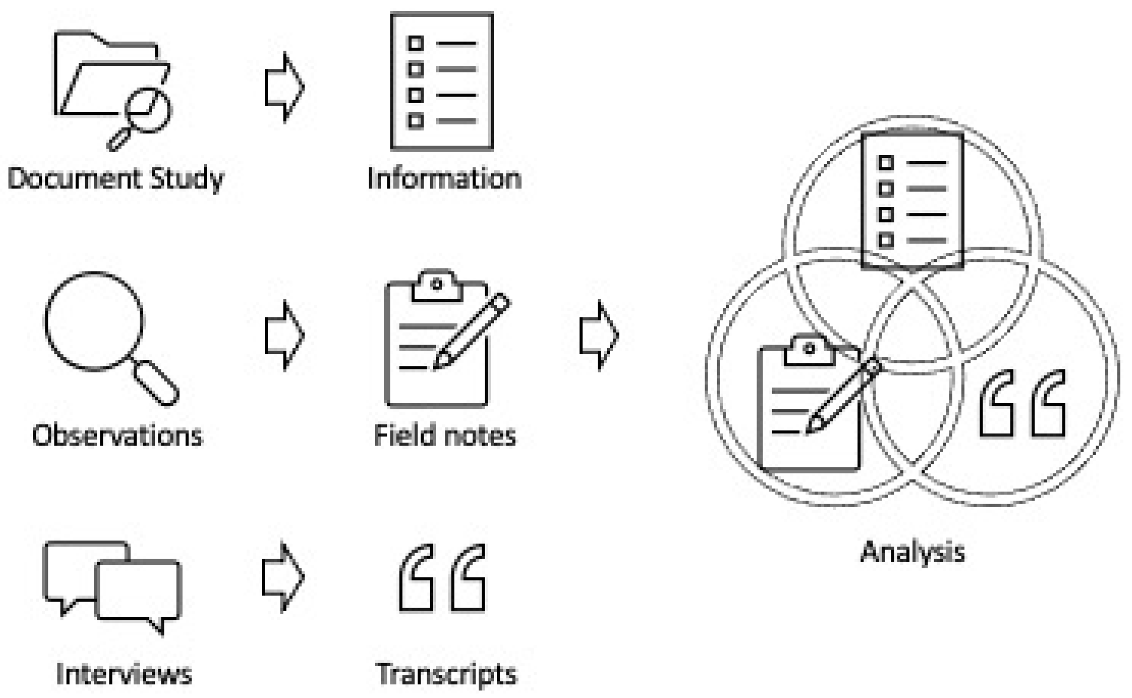
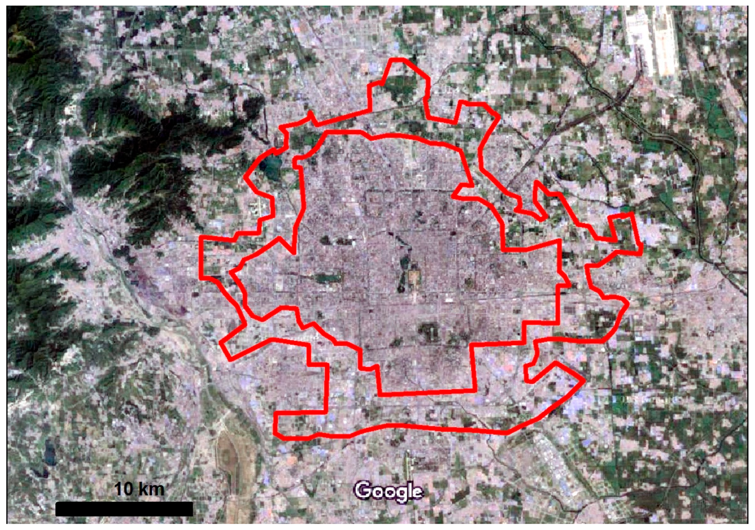
2. Materials and Methods

In this paper, we analyse the making of the first green belt, from the first ideas and plans in the 1950s until it was officially declared as finished in 2004. How did the green belt idea evolve over time, how was it put into practice, and how was it influenced by contemporary political and socio-economic agendas?
To answer these questions and establish the construct validity and reliability of the case study, we collected multiple sources of evidence, including document study, direct observations, and interviews. Through desk-based and fieldwork studies, we have collected multiple sources of evidence to support the analysis, as shown in the Figure 1 below.
First, we give an in-depth account of the important planning documents and events related to the green belt since the proclamation of the P.R. China in 1949. The most important documents include the several City Master Plans of Beijing that we will discuss in the next section, as well as the green belt related official documents listed in Table 1 below. Many materials were acquired from official archives and planning institutions, including national and local policies, regulations and plans.
We have also visited the case areas multiple times which gave us the opportunity for direct observations of the current status of the green belt. Besides site visits, the fieldwork included semi-structured interviews with 4 experts: 2 with former senior officials from the municipal government and the City’s Planning Institute and 2 with active planners in the City’s Planning Institute. The interviews were especially helpful to get hold of unpublished documents and insights into discussions and debates at the time. We are aware that our source material mainly refers to official documents and planners’ perspectives which is caused by the historical and contextual nature of the case. We will critically discuss that at the end of the paper. Moreover, before going deeper into the case we will provide a short review of the general idea of a green belt, which we later use to discuss the case’s specificities.
We have used a mixed methods approach for data collection and analysis which permits a synergistic utilisation of data from various sources. The document study provided a good collection of quantitative data which are supplemented by qualitative data from site observations and interviews. We have compared and analysed findings with quantitative and qualitative data sources which provided validation for each other. The consolidated results are presented in the next section.

3. Results

The development of the first green belt in Beijing was a prolonged project covering the first semi-century of P. R. China. This half a century witnessed a constantly transforming period in the country, along with which the green belt was initiated and developed step by step.

3.1. A First Hint of the Green Belt

“On 16 September [1949], a group of Soviet experts in municipal administration arrived in Beijing. They were supposed to help the new government in its work to plan the city’s development. In reality, however, they were to have absolute say in everything.”
[35], p. 38, authors’ translation
When Beijing became the capital of the People’s Republic of China in 1949, there was a debate about the location of the administrative centre: should the old town be renovated, or a new town be built? Two factors finally lead to the success of the old town strategy and a monocentric plan for Beijing was finally determined as a guideline for future city development [36]. Firstly, the new-born Chinese government was significantly influenced by the Soviet Union. In ‘Report on Beijing’s Development Plan in the Future’ in 1949, Soviet Planner M. G. Barannikov suggested the expansion of Tiananmen Square as the city centre, like the Red Square in Moscow. Secondly, another plan for building a new administrative centre in a western suburb was denied by the government, because of the larger expenses for new construction costs. There were 1.65 million residents and about 20 million m2 of buildings in the old town, but only tens of thousands m2 in the proposed new centre, Gongzhufen [37]. After this debate, the 1954 master plan for Beijing was set as a monocentric structure aiming to a megacity with 5 to 6 million population.
The political condition changed dramatically after 1954 and the changes had immediate impact on planning. Because of political movements and economic recession, evacuating urban population to the suburbs and countryside became an order from the central government [38]. However, at that time, the city had already expanded to a vast area with a very low density as a side product of the radical growth movement “Great Leap Forward”, and built-up areas were spread out in several suburban centres. In 1954, there were 4.5 million m2 (floor area) new buildings spread out of the city centre [39]. Later in 1958, the “National Landscaping and Gardening Movement” started and aimed at turning the whole country into a “big beautiful park” [40] and then as an immediate consequence, the city was asked to offer its territory for greening. In the recast 1958 master plan, the pattern of “decentralized groups” became a dominant feature (see Figure 2) [36]. The idea of this plan aimed to decentralise city development so as to keep a green belt between the centre and suburbs. The “decentralized groups” were a compromise between reality and future development expectations, keeping flexible for the future [39]. The designated vacant land between the decentralized urbanized groups was thought to be productive land, supplying vegetables to the city [36].
Apparently, the green belt was not the priority in this plan, as it was not even drawn on the plan map, but only left blank to highlight the pattern of the decentralized groups (see Figure 2). However, it is widely believed that the idea of “decentralized groups” in 1958 firstly indicated the conception for a green belt [2,41].

3.2. New Urban Planning Ideas and Challenges Lead to a New Proposal of the Green Belt

“The size and population of the city was uncertain during the dramatic development. In this situation, only a proper layout plan could keep the space for future development. The “decentralized groups” was a reasonable model to achieve this purpose. It was generated from history, with the feature of flexibility.”
[39], p. 11, own translation
While the 1958 master plan was being formulated, China went into a long phase of political turmoil. The Sino-Soviet Split, started in 1958, resulted in the loss of aid from the Soviet Union; meanwhile, radical communism reform movements led to more serious economic recession and food shortages, followed by migration from the city to the countryside [42]. The direct consequence was the reduction of urban populations, especially in big cities.
During the Cultural Revolution (1966–1976), most of the governmental operations were interrupted, including planning. A master plan was published in 1973 (Figure 2), which mainly followed the 1958 plan, though with considerable reductions of urban land in the outskirts of the city. The plan, however, never got implemented. Still, it is notable that the idea of the ‘decentralized groups’ was kept alive, at least in the planners’ heads.
Only after the “economic reforms and openness” in 1978, China returned gradually to normality and economic development became the priority. The population in Beijing increased rapidly along with the economic boost [43], which soon triggered the wild urban development.
The rapid—and sometimes disordered—development turned lots of green areas into built-up areas. According to the master plans, 314 km2 green belt areas was planned between the decentralized groups in 1958, but it decreased to 260 km2 in 1983, and then to 240 sq. km in 1993 (see Table 2). Meanwhile, environmental problems, especially air pollution and sandstorms appeared in parallel with the rapid urbanization, thus the causality between pollution and development was widely discussed [44,45,46]. The green belt was back on the table and considered as a green cushion to protect the city against sandstorms while also improving air quality [19].
The green belt approach was reinstated from the former plans (i.e., the 1958 master plan) and given much attention in the 1993 master plan. So although the green belt was designed several decades ago, it was not implemented as a belt until new problems occurred along with economic development.
Figure 2. Master plans from 1958, 1983, and 1993, from the top down. The red/black line is added to indicate the green belt as planned in 1993 [49].
Land 10 00969 g002aLand 10 00969 g002b

3.3. Implementing the Green Belt in a Time of Rapid Urban Growth and New Ambitions

“No fund but only supporting policies from the government; this was the precondition. Could we implement the green belt with the help of real estate development? And don’t forget, the farmers needed to be resettled and reallocated.” (Former official at Beijing Planning Institute, interview with author, own translation)
Suffering from a bad reputation due to air pollution and sandstorms, Beijing failed in the competition for hosting the Olympic Games in 1993, which hit the city badly. Solving the environmental problems got great political attention and various actions, among them the implementation of the green belt, followed. The green belt was implemented through a series of policies and regulations, released in the following years. A main tool was the establishment of parks and tree planting which already started in 1993, when a new master plan was announced. As lots of building construction had already happened in the green belt area, the 1993 Beijing master plan [47] stated a reduced but more realistic target of 140 km2 of greening areas out of the 240 km2 green belt area. Figure 3 shows the green belt and the location of 19 pilot villages and surrounding green areas, indicating the area of the first green belt between the city centre and ten suburban towns. The second green belt outside of the fifth ring road was also proposed in the 1993 master plan.
The implementation of the green belt was supported by several executive orders from the city government. One of the most important was published in 1994, executive order 1994 [7] “The proposal of greening construction in green belt”. According to this order, the actual green area in the green belt was only 20 km2 in 1994, far less than the target of 140 km2 [50]. In the same order, another policy was announced, “Green Supports Green”, which soon became a guiding principle. This policy responded to the new condition in the area and was considered as the actual start of the green belt development. As the land price rose sharply along with the economic growth in the 1990s [51], the cost of purchasing land for building the green belt became much higher, beyond the affordability of the governments. This policy aimed at raising funding by a real estate approach, without acquiring financial support from the government. The basic idea was that the sub-local governments (mainly villages and a few towns) got the permission to operate real estate development and built high-rise settlements in certain limited areas. The newly built housing should be used mainly for allocating farmers and the rest for sale in order to cover the cost for maintaining the green belt. After that, the land in former villages and farmland became state-owned and transferred to be part of the green belt.
Since the sub-local governments had neither initial capital nor relevant experience for real estate development, external developers were invited to be partners. The work was allotted to the two parties: (1) the sub-local governments took charge of negotiation with farmers and land acquisition; (2) external real estate companies got the land from sub-local governments and took responsibility to invest and build infrastructure, resettlement housing and commercial housing.
There was only a weak connection between the municipal government’s initiation and executors in reality, and in the sub-local government and companies. Sub-local government is the key actor in carrying out plans in China. Implementation plans were made by sub-local government based on the master plan from city level, but the plan for the green belt was solely initiated by the municipal level. Therefore, sub-local governments’ concern was not considered in the green belt plan. Those were, however, facilitating market forces to achieve economic growth [52]. Commercial operations in the green belt became a common agreement between sub-local government and development companies.
This approach was later summarized as a slogan, “Green attracts investment, investment drives development, development builds green, green supports green” [36].
The mode of cooperation and profit distribution was set based on the actual situation in different villages or towns, with the supervision of Beijing municipal government. The sub-local governments would get 30–50% of the newly built housing, without any financial investment, and developers got the rest as return on investment [53].
This policy was supposed to be a win-win solution for the three parties: the government received funds for building and maintaining the green belt, the residents got their living conditions improved, and the developers acquired land in a fine location, without problems with demolition and resettlement.
However, a hidden conflict between farmland acquisition and the state land law soon disrupted this policy [54]. The farmland in the green belt area was protected by the state land law. Therefore, the land acquisition by sub-local government was stopped as it was against the land protection law. A nationwide survey of cultivated land in China in 1996 revealed the rapid reduction of cultivated land and caused the project to be set on hold [36].
The green belt project was suspended until 1999, when Beijing was preparing a new bid for hosting the 2008 Olympic Games. It was recommissioned as a way of improving the terrible environmental pollution in Beijing. The measures from executive order no. 7 in 1994 were partly adopted, but the previous method of land acquisition was abandoned. Instead, farmlands were rezoned as economic forests and financially supported by the government. Subsequently, detailed measures were formulated, e.g., financial subsidies, compensation, and investment management. There were also financial subsidies for maintaining the green areas for the first time [55].
In 2000, the successful bid for the 2008 Olympic Games accelerated the green belt construction to a large extent. A high-level joint committee was established as a leadership group for green belt construction [56]. Meanwhile, boundary markers were established around the green belt [57,58], which were anticipated to guard the green belt. These measures showed the government’s determination on implementing the green belt during that time. Then finally, Beijing’s first green belt was announced as finished in 2004, well before the 2008 Olympic Games.
After the first green belt project finished, a study [2] shows that the green space increased in the green belt areas in 2005, compared to 1992. However, although the tree cover increased, the agriculture land and water area decreased, meanwhile the built-up area also increased.

4. Discussion and Perspectives

Following the milestone planning documents, it is clear that there were important factors putting the plan into practice.

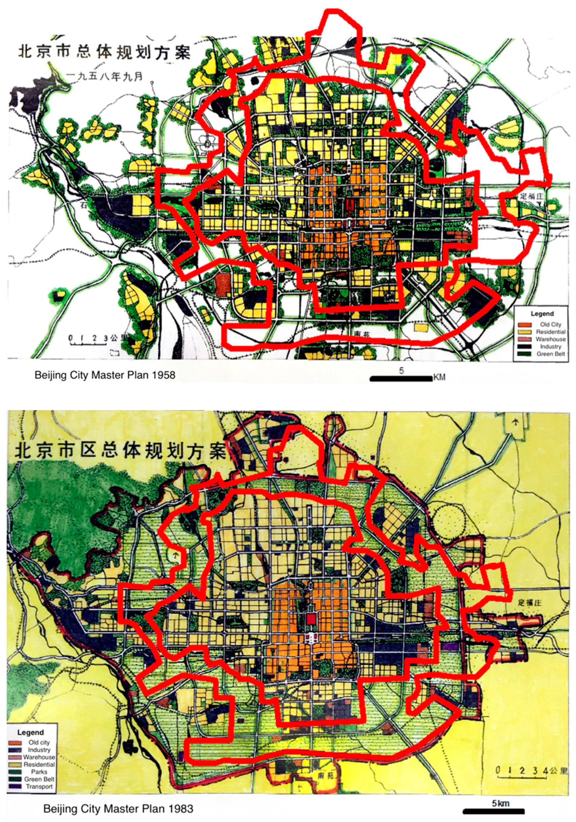
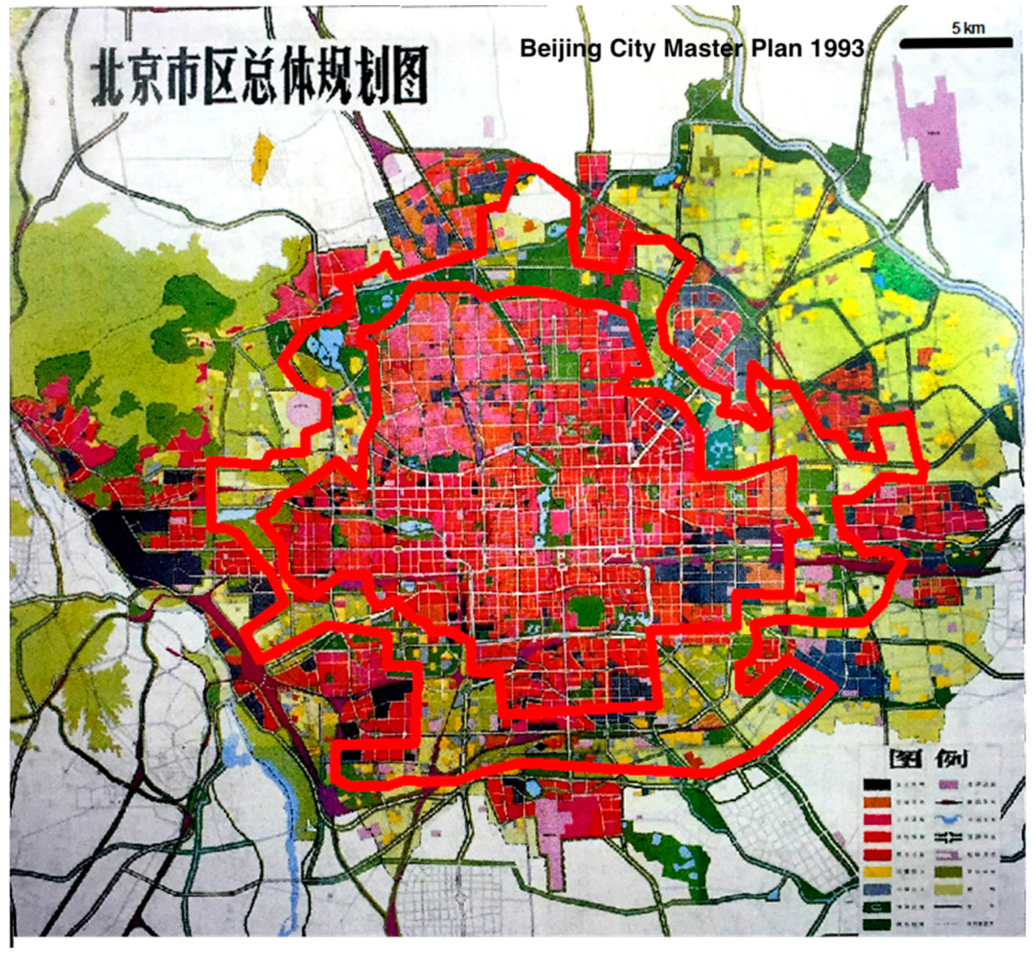
4.1. The Idea Evolves with the Master Plans from 1958 and 1993

The green belt idea got through times of crisis and prosperity in China. Looking back, three important planning phases culminating in important planning documents and milestones can be identified:
The first years for the PRC up to the adoption of the 1958 master plan. The green belt was, for the first time, proposed in an official document; even though not implemented specifically, the concept kept alive in all following master plans.
The years of rapidly increasing urbanization pressure since the 1970s and 1980s, finally reinstating a strong green belt concept in the master plan of 1993.
The years of implementation with numerous practical regulations released up to the time when it was declared finished in 2004.
The focus of the policies in different periods varied during the process, indicating the change of expected functions of the green belt (see also Table 2). Seen as ‘isolation areas’ in 1958, as well as in 1973 and 1983, the green belt was considered as a buffer zone to separate the city centre and suburban towns, which can be clearly recognized on the master plans in Figure 2; however, the idea followed no specific action towards implementation. Only with the pressure of rapid urban development and severe air pollution, the green belt was brought up again as a mitigation instrument in 1990s. The 1993 master plan finally initiated the implementation and special policies for the green belt were announced. The process was interrupted in 1996 because of its conflict with farmland reservations but restarted in 1999 to assist in the Olympic Games bid [36]. New policies abandoned the approach from the 1994 order but paid more attention to strict control and financial subsidies.
Over the decades the green belt changed from being a buffer zone between satellite towns (‘decentralized groups’) and the city centre, to an area for recreation with air cleaning functions combined with green industries. The adaptability of the concept to changing situations contributed to its longevity. However, the green belt was lacking concrete formulated goals or criteria, e.g., regarding the containment of urban growth, green infrastructure for recreation, or air improvement. This uncertainty left space for flexible operations at the sub-local level. The immediate result was that a large part of the green belt was converted to become, for example, golf courses or even built-up areas.

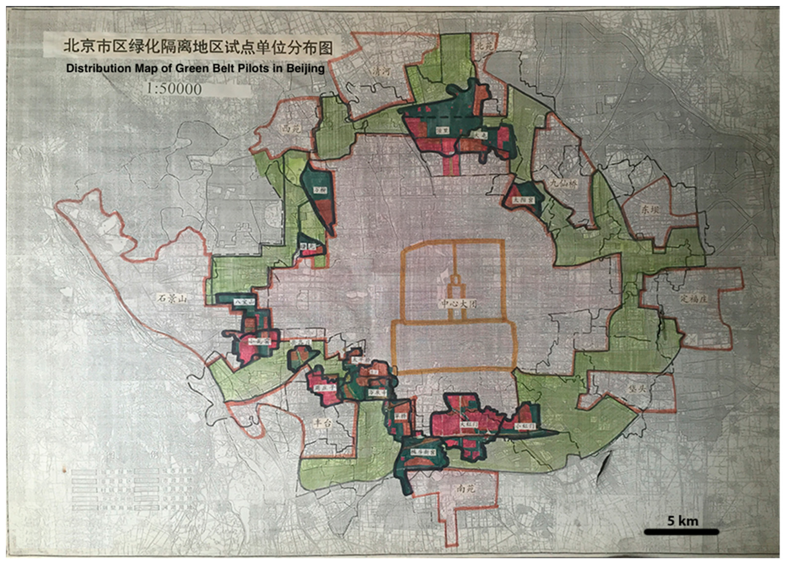
4.2. Putting the Green Belt into Practice-Regulations and Legislation, and the Sub-Local Level

Pollution and the Olympic Games raised the political will for the green belt, but this will only exist at the higher-level authorities, i.e., the central and municipal governments. The loose connection between the initiator (municipal government) and the implementation at the sub-local level (village and town governments) became a problem in practice. Several municipal governmental departments played the role as supervisors, but no single player was able to get the overall control. This left the programme soon to become a free play by the sub-local governments and companies.
The municipal government’s reaction to this was a series of regulations and policies. There were several policies and measures created for the green belt project, which were innovative and different from other cases. The collective land ownership in China made land acquisition and compensation rather complicated, as the villages and towns which own the land must find a balance between many interests when changing land rights. The “green supports green” policy was a response to this issue and facilitated several pilot projects [36], but its legal validity was questioned, and the policy was suspended after a short experimental period. The substitute policy in 1999 paid more attention to legal validity but did not provide an economically sustainable solution for maintenance, although temporary financial subsidies supported the implementation. However, the green belt lacked at comprehensive law specifying rules and regulations and taking account for the special land ownership. Moreover, the ongoing policy changes in the 1990s resulted in a mosaic of regulations effective in different areas of the green belt. With this dilemma, the consequent challenges for maintaining the green belt seemed to be unavoidable.

4.3. Political and Socio-Economic Dynamics-Pollution and Olympic Games Finally Made it Happen, but as a Compromise Far from the Original Vision

In the rapid growth years with urbanization and environmental pollution, the green belt got strong political and public attention again, peaking in 1993 when Beijing failed the first bid for hosting the Olympic Games. The environment pollution was considered as an important factor for this failure and the green belt became an iconic project coping with the environmental problems. There was also a wide discussion in the newspapers and on TV and the green belt was among the most popular solutions in response to those problems [25]. The public pressure as expressed in media increased the political will for improvements. Meanwhile, the tight deadline before Olympic Games pushed the implementation of the green belt to progress much faster than normal.
The implementation also fell in a dynamic period regarding the urban political economy in China. Economic globalisation accelerated the decade after 1993. Foreign investments doubled from 1992 to 1993 and almost doubled again in 1994 [59]. To attract and accommodate these foreign investments, local governments in China established exclusive zones called “economic and technological development zones” (ETDZs). Soon the premium of land leasing in these ETDZs became a large source of government revenue [60], which left the local and sub-local governments at a weak position in the negotiations with foreign investment. The foreign investments and foreign tourists also stimulated the need for new types of entertainment, including and increasing demand for golf courses [61].
This dynamic period also witnessed the rocketing of land price in Beijing, following the increase of investment. Funding to purchase land, implement the green infrastructure, and maintain it became a hard nut to crack. Cooperation with external developers within the “Green Support Green” policy provided funding in the beginning, but a conflict with the state land law forfeited this approach. The strong political will resulted in subsidies for land acquirement, but the unexpected boom of land price made it impossible to continue. A sustainable mechanism for financial support with consideration of future changes was missing.
Under these pressures the urban area increased, and the green belt area decreased (see Table 2). The focus in the green belt was also adjusted several times opening doors for commercial operations in disguised form. The green belt located in the “blank” areas was a feasible plan back in 1958. However, after decades of development, the plan in 1993 was a quite ambitious project compared to the constructed reality in the 1990s, not to say an unrealistic vision at that time. On a satellite image from 2006, two years after the declared completion, the green belt area can hardly be recognized (Figure 4) and many of the remaining green areas are not connected [5].

4.4. Lessons to Draw for Future Green Belt Planning

It is rare to see that a planning idea like the green belt could live through for half a century in China, especially in its quick-changing capital city. Through its ups and downs, we get a chance to investigate the political, social, and economic changes and its relation to planning and policy transfer.
This study gives a thorough review of the process and reveals it was a pragmatic decision to keep, adapt and finally implement the green belt in Beijing. In the first years, a green belt between the city centre and suburbs was to keep some flexibility for the future development, while the belt shape was adapted to the existing city structure well. Later, beside the function for urban containment, the green belt was expected to tackle environmental problems and ambitions for the city development in regards the Olympic Games, which led to a range of concrete policies in 1990s and 2000s, aiming at realising the green belt.
Our source material is, however, limited to mainly official views from Beijing’s municipal planning. Considering the complex background especially in the implementation phase, views from sub-local governments or private developers may had offered different perspectives for the interpretation of the development process. Taking the “Green Support Green” policy as an example, it was considered as an innovative and effective approach by the planners but could potentially be economic unsustainable for sub-local governments and private developers.
The case of the first green belt in Beijing shows the importance of several influencing factors, including political will and funding support, legislation and regulation, concrete goals and comprehensive planning, social and economic context. This is similar to studies from other green belt cases. Our case shows that there are significant synergies between the factors, and they can hardly be looked at isolated. The case also shows that a strong planning vision with a certain flexibility fitting the local context can remain over a long period of time. Beijing’s planners kept the green belt, despite no possibilities for its realisation, in the plans over the decades until the city’s development required its implementation. However, it also shows that planning ideas can be somehow far from the actual development on the ground, which was also reflected in the policy transfer in between as descripted previously. When the green belt was taken seriously finally in the 1990s, much of it was already lost to development.
One of the green belt idea’s strengths lies in its clear spatial vision of having a continuous “belt” shape. As shown by other studies, this can though increase housing prices in the remaining areas and lead to a housing shortage [11]. The proposal to down scale the green belt to be a “belt of parks” was a response to that, which reduced the possibilities to control urban growth [62]. A belt is, however, not the sole way for a strong green infrastructure vision. Green wedges, green hearts, green corridors, etc., have been implemented successfully with similar strong spatial vision, and plans for the second green belt in Beijing also consider other spatial models [63,64]. The impact on social justice in relation to housing affordability and public accessibility to green space should be considered when making policies, which can be improved in the Beijing case. A way to mitigate the growth challenges is working with land supply mechanisms on a larger scale. The master plan initiative is one of Beijing’s strengths and has the potential to better integrated the green belt needs with other plans of the municipality, as e.g., the land resource plan or the greening plan, in the future.

Author Contributions

Conceptualization, L.S., C.F. and G.J.; Writing—original draft, L.S.; Writing—review & editing, C.F. and G.J. All authors have read and agreed to the published version of the manuscript.

Funding

This research was funded by China Scholarship Council (CSC), grant number [2014]3026.

Institutional Review Board Statement

Not applicable.

Informed Consent Statement

Not applicable.

Data Availability Statement

The data presented in this study are openly available as listed in References section.

Conflicts of Interest

The authors declare no conflict of interest.

References

  1. MOHURD. Statistical Yearbook of City Development 2015; Ministry of Housing and Urban-Rural Development: Beijing, China, 2015.
  2. Ouyang, Z.; Wang, R.; Li, W.; Juergen, P.; Li, D.; Xiao, Y.; Wang, X. Ecological planning on greenbelt surrounding mega city, Beijing. Acta Ecol. Sin. 2005, 25, 965–971. [Google Scholar]
  3. Yang, J.; Jinxing, Z. The Failure and Success of Greenbelt Program in Beijing. Urban For. Urban Green. 2007, 6, 287–296. [Google Scholar] [CrossRef]
  4. Zhao, P. Managing Urban Growth in a Transforming China: Evidence from Beijing. Land Use Policy 2011, 28, 96–109. [Google Scholar] [CrossRef]
  5. Han, X. From Green Belt to Green Corridor: Case Study from Beijing Green Belt. Urban Probl. 2004, 2, 5. [Google Scholar]
  6. Ma, M.; Jin, Y. What If Beijing Had Enforced the 1st or 2nd Greenbelt?—Analyses from an Economic Perspective. Landsc. Urban Plan. 2019, 182, 79–91. [Google Scholar] [CrossRef]
  7. Han, H.; Long, Y. Green or Green Space?—Effect Analysis of the First Green Belt of Beijing. Beijing Plan. Rev. 2010, 3, 59–63. [Google Scholar]
  8. Amati, M. Urban Green Belts in the Twenty-First Century; Ashgate Publishing Ltd.: Farnham, UK, 2012; ISBN 1-4094-8790-3. [Google Scholar]
  9. DCLG. National Planning Policy Framework; UK Department of Communities and Local Government: London, UK, 2012.
  10. Elson, M.J. Green Belts: Conflict Mediation in the Urban Fringe; Heinemann: Portsmouth, NH, USA, 1986; ISBN 978-0-434-90532-4. [Google Scholar]
  11. Bengston, D.N.; Youn, Y.-C. Urban Containment Policies and the Protection of Natural Areas: The Case of Seoul’s Greenbelt. Ecol. Soc. 2006, 11. [Google Scholar] [CrossRef]
  12. Miller, M. The Elusive Green Background: Raymond Unwin and the Greater London Regional Plan. Plan. Perspect. 1989, 4, 15–44. [Google Scholar] [CrossRef]
  13. Ali, A.K. Greenbelts to Contain Urban Growth in Ontario, Canada: Promises and Prospects. Plan. Pract. Res. 2008, 23, 533–548. [Google Scholar] [CrossRef]
  14. Taylor, J.; Paine, C.; FitzGibbon, J. From Greenbelt to Greenways: Four Canadian Case Studies. Landsc. Urban Plan. 1995, 33, 47–64. [Google Scholar] [CrossRef]
  15. Yokohari, M.; Takeuchi, K.; Watanabe, T.; Yokota, S. Beyond Greenbelts and Zoning: A New Planning Concept for the Environment of Asian Mega-Cities. Landsc. Urban Plan. 2000, 47, 159–171. [Google Scholar] [CrossRef]
  16. Boentje, J.P.; Blinnikov, M.S. Post-Soviet Forest Fragmentation and Loss in the Green Belt around Moscow, Russia (1991–2001): A Remote Sensing Perspective. Landsc. Urban Plan. 2007, 82, 208–221. [Google Scholar] [CrossRef]
  17. Amati, M.; Yokohari, M. The Actions of Landowner, Government and Planners in Establishing the London Green Belt of the 1930s. J. Jpn. Inst. Landsc. Archit. 2004, 67, 433–438. [Google Scholar] [CrossRef]
  18. Wang, H.; Li, H.; Ming, H.; Hu, Y.; Chen, J.; Zhao, B. Past Land Use Decisions and Socioeconomic Factors Influence Urban Greenbelt Development: A Case Study of Shanghai, China. Landsc. Ecol. 2014, 29, 1759–1770. [Google Scholar] [CrossRef]
  19. Yu, X.J.; Ng, C.N. Spatial and Temporal Dynamics of Urban Sprawl along Two Urban–Rural Transects: A Case Study of Guangzhou, China. Landsc. Urban Plan. 2007, 79, 96–109. [Google Scholar] [CrossRef]
  20. Wu, Y. Socialist Urbanization of China. City Plan. Rev. 1979, 5, 13–25. [Google Scholar]
  21. Yang, J.; Wu, T.; Gong, P. Implementation of China’s New Urbanization Strategy Requires New Thinking. Sci. Bull. 2017, 62, 81–82. [Google Scholar] [CrossRef] [Green Version]
  22. Shen, L.; Cheng, S.K.; Gunson, A.J.; Hui, W. Urbanization, Sustainability and the Utilization of Energy and Mineral Resources in China. Cities 2005, 22, 287–302. [Google Scholar] [CrossRef]
  23. Bai, X.; Shi, P.; Liu, Y. Society: Realizing China’s Urban Dream. Nature 2014, 509, 158. [Google Scholar] [CrossRef] [Green Version]
  24. Zhou, Y. Opinions on the Speed of Urbanization in China. City Plan. Rev. 2006, 30, 32–35. [Google Scholar]
  25. Li, M. Reasons of the Four Sandstorms in Beijing in March. Beijing Evening News, 29 March 2000. [Google Scholar]
  26. Zhu, K. 100 billion for Better Environment Supporting Bid for Olympics. Chin. J. Environ. Eng. 2001, 1, 95. [Google Scholar]
  27. Zhang, Q.; Crooks, R. Toward an Environmentally Sustainable Future: Country Environmental Analysis of the People’s Republic of China; Asian Development Bank: Mandaluyong, Philippines, 2012. [Google Scholar]
  28. Yan, X.; Jia, L.; Li, J.; Weng, J. The Development of the Chinese Metropolis in the Period of Transition. In The New Chinese City; Blackwell Publishers Ltd.: Oxford, UK, 2008; pp. 37–55. ISBN 978-0-470-71286-3. [Google Scholar]
  29. Zhou, Y. On the Suburbanization of Beijing. Sci. Geogr. Sin. 1996, 3, 198–206. [Google Scholar]
  30. Zhou, Y.; Meng, Y. Suburbanization in Big Chinese Cities. Urban Plan. Forum 1998, 3, 22–27. [Google Scholar]
  31. Liu, J.; Zhan, J.; Deng, X. Spatio-Temporal Patterns and Driving Forces of Urban Land Expansion in China during the Economic Reform Era. AMBIO J. Hum. Environ. 2005, 34, 450–455. [Google Scholar] [CrossRef]
  32. Hong, W.; Guo, R. Indicators for Quantitative Evaluation of the Social Services Function of Urban Greenbelt Systems: A Case Study of Shenzhen, China. Ecol. Indic. 2017, 75, 259–267. [Google Scholar] [CrossRef]
  33. Leading Group Office of Shanghai Master Plan. Shanghai Master Plan 2016–2040; Leading Group Office of Shanghai Master Plan: Shanghai, China, 2016.
  34. Kong, F.; Nakagoshi, N. Spatial-Temporal Gradient Analysis of Urban Green Spaces in Jinan, China. Landsc. Urban Plan. 2006, 78, 147–164. [Google Scholar] [CrossRef]
  35. Wang, J. Beijing Record; SDX Joint Publishing: Beijing, China, 2003; ISBN 978-7-108-01816-8. [Google Scholar]
  36. Beijing Municipal Commission of Urban Planning. Echoes of the Years—Record of the 60 Years of Planning for the Capital City; Urban Planning Society of Beijing: Beijing, China, 2009. [Google Scholar]
  37. Liang, S.; Chen, Z. Liang-Chen Plan and Beijing; Liaoning Education Press: Shenyang, China, 2005. [Google Scholar]
  38. Zhu, T. Nationalism and Chinese Foreign Policy. China Rev. 2001, 1, 1–27. [Google Scholar]
  39. Chen, G. Jinghuadaisilu: Anthology of Chen Gan; Beijing Municipal Institute of City Planning & Design: Beijing, China, 1996. [Google Scholar]
  40. Zhao, J. A Historical Review of “Land Gardenization Movement”. Chin. Landsc. Archit. 2010, 10, 56–60. [Google Scholar]
  41. Li, F.; Wang, R.; Paulussen, J.; Liu, X. Comprehensive Concept Planning of Urban Greening Based on Ecological Principles: A Case Study in Beijing, China. Landsc. Urban Plan. 2005, 72, 325–336. [Google Scholar] [CrossRef]
  42. Gooch, E. Estimating the Long-Term Impact of the Great Chinese Famine (1959–1961) on Modern China. World Dev. 2017, 89, 140–151. [Google Scholar] [CrossRef]
  43. Golley, J.; Wei, Z. Population Dynamics and Economic Growth in China. China Econ. Rev. 2015, 35, 15–32. [Google Scholar] [CrossRef]
  44. Amsden, A.H.; Dongyi, L.; Xiaoming, Z. China’s Macroeconomy, Environment, and Alternative Transition Model. World Dev. 1996, 24, 273–286. [Google Scholar] [CrossRef]
  45. Cao, S.; Chen, L.; Liu, Z. An Investigation of Chinese Attitudes toward the Environment: Case Study Using the Grain for Green Project. AMBIO J. Hum. Environ. 2009, 38, 55–64. [Google Scholar] [CrossRef] [PubMed]
  46. Liu, X.; Mu, R. Public Environmental Concern in China: Determinants and Variations. Glob. Environ. Chang. 2016, 37, 116–127. [Google Scholar] [CrossRef]
  47. BICP. Beijing Master Plan 1991–2010; Beijing Municipal Institute of City Planning & Design (BICP): Beijing, China, 1992. [Google Scholar]
  48. BICP. Beijing Master Plan 2004–2020; Beijing Municipal Institute of City Planning & Design (BICP): Beijing, China, 2005. [Google Scholar]
  49. Compilation Committee of Beijing Records. Beijing Records: Urban and Rural Planning Volume. Planning Records; Beijing Publishing House: Beijing, China, 2009; ISBN 978-7-200-06807-8. [Google Scholar]
  50. Capital Planning and Construction Commission. Request for Instructions on Greening in Green Belt Areas; Capital Planning and Construction Commission: Beijing, China, 1994. [Google Scholar]
  51. Zhang, X.Q. Urban Land Reform in China. Land Use Policy 1997, 14, 187–199. [Google Scholar] [CrossRef]
  52. Tian, Y.; Yin, K.; Lu, D.; Hua, L.; Zhao, Q.; Wen, M. Examining Land Use and Land Cover Spatiotemporal Change and Driving Forces in Beijing from 1978 to 2010. Remote Sens. 2014, 6, 10593–10611. [Google Scholar] [CrossRef] [Green Version]
  53. Zhao, Z. Opinions on the Construction of the Green Belt in Beijing. Beijing City Plan. Constr. Rev. 2003, C00, 27–28. [Google Scholar]
  54. Hu, W. Household Land Tenure Reform in China: Its Impact on Farming Land Use and Agro-Environment. Land Use Policy 1997, 14, 175–186. [Google Scholar] [CrossRef]
  55. Beijing Leadership Group of Green Belt Construction. Interim Measures on Accelerating the Construction of Green Belt; Beijing Leadership Group of Green Belt Construction: Beijing, China, 2000. [Google Scholar]
  56. Beijing Government Office. Notice on the Establishment of Leadership Group and General Headquarters of Green Belt Construction; Beijing Government Office: Beijing, China, 2000.
  57. Beijing Leadership Group of Green Belt Construction and Planning Committee. Notice on the Implementation of Boundary Markers in Green Belt Area; Beijing Leadership Group of Green Belt Construction and Planning Committee: Beijing, China, 2000. [Google Scholar]
  58. Beijing Municipal Commission of Urban Planning. Regulations on Protection and Management of Boundary Markers in Green Belt Area; Urban Planning Society of Beijing: Beijing, China, 2001. [Google Scholar]
  59. State Statistical Bureau. China Statistical Yearbook 1998; China Statistical Press: Beijing, China, 1998.
  60. Wu, F. China’s Recent Urban Development in the Process of Land and Housing Marketisation and Economic Globalisation. Habitat Int. 2001, 25, 273–289. [Google Scholar] [CrossRef]
  61. Deci, Z. The Open Door Policy and Urban Development in China. Habitat Int. 1996, 20, 525–529. [Google Scholar] [CrossRef]
  62. Guo, Z.; Xu, B.; Zhong, J. Opinions on building “belt parks” in Beijing green belt area. Beijing Landsc. Archit. 2009, 4, 7–11. [Google Scholar]
  63. Kühn, M. Greenbelt and Green Heart: Separating and Integrating Landscapes in European City Regions. Landsc. Urban Plan. 2003, 64, 19–27. [Google Scholar] [CrossRef]
  64. Lemes de Oliveira, F. Green Wedges: Origins and Development in Britain. Plan. Perspect. 2014, 29, 357–379. [Google Scholar] [CrossRef] [Green Version]
Figure 1. Research methods and process.
Land 10 00969 g001
Figure 3. The 1993 plan map for first green belt in Beijing, showing the green belt (light green) and the location of 19 pilot villages (red) and surrounding green areas (dark green), indicating the area of the first green belt between the city centre (orange lines in the middle) and ten suburban towns (pink lines out of the green belt). Source: Private collection of a former planner, photo by author.
Land 10 00969 g003
Figure 4. Satellite image of Beijing in 2006 (Source: Google). The red line indicates the first green belt in Beijing as planned in the 1993 master plan.
Land 10 00969 g004
Table 1. Relevant official documents beyond the Master Plans.
DateTitle of DocumentAuthority
31.07.1993Emergency notice about strict control on the development and construction in green belt areasFormulated by Capital Planning & Construction Commission, forwarded by Beijing Government office
20.01.1994Request for instructions on greening in green belt areasFormulated by Capital Planning & Construction Commission, authorized by Beijing Government
25.11.1996Request for instructions on relevant policies during the construction of green beltFormulated by Beijing Municipal Commission of Urban Planning, authorized by Beijing Government
29.02.2000Notice on the establishment of leadership group and general headquarters of green belt constructionReleased by Beijing Municipal Government Office
20.03.2000Suggestions for accelerating the construction of green beltReleased by Beijing Municipal Government
29.03.2000Interim measures on accelerating the construction of green beltFormulated by Beijing leadership group of green belt construction, forwarded by Beijing government office
27.10.2000Notice on the implementation of boundary markers in green belt areaFormulated by Beijing leadership group of green belt construction and planning committee, forwarded by Beijing government office
20.04.2001Notice on accelerating the renovation and construction of new villages in green belt areaFormulated by Beijing leadership group of green belt construction, forwarded by Beijing government office
23.05.2001Suggestions to improve the economic development in green belt areaFormulated by Beijing agriculture committee, forwarded by Beijing government office
06.07.2001Suggestions on implementation of master plan for green space system in green belt areaFormulated by Capital Greening Office, forwarded by Beijing government office
14.08.2001Regulations on protection and management of boundary markers in green belt areaFormulated by Beijing Municipal Commission of Urban Planning, forwarded by Beijing Government office
26.09.2001Notice on personnel adjustment of leadership group and general headquarters of green belt constructionReleased by Beijing Municipal government office
30.12.2001Regulations on land use replacement in green belt areaFormulated by the Beijing Municipal Bureau of Land and Housing Management, forwarded by Beijing government office
Table 2. Changes in planned urban area and planned green belt area in Beijing, Sources: [36,39,47,48].
Year of Master PlanPlanned Urban Area in City Centre (km2)Planned Green Belt Area (km2)Main Focus in the Green Belt
1954600N/ANo green belt in this master plan.
1958600314Restricted areas between city centre and decentralized groups.
1978600314Same as 1958.
1983440
(750 in whole municipality)
260Restricted areas between city centre and decentralized groups, 60% to be planted trees.
1993610
(900 in whole municipality)
240Restricted areas between city centre and decentralized groups. Forests and parks. Certain percentage of the land could be used as cultural and recreation facilities upon approval.
2004778
(1650 in whole municipality)
240Restricted areas between city centre and decentralized groups. Recreation and ecological protection. Green and high-tech industries are prioritized to promote employment.
Publisher’s Note: MDPI stays neutral with regard to jurisdictional claims in published maps and institutional affiliations.

