Article

The Fit for Purpose Land Administration Approach-Connecting People, Processes and Technology in Mozambique

1
Departamento de Ciências Sociais e de Gestão, Universidade Aberta, 1250-100 Lisboa, Portugal
2
Faculty of Geo-Information Science and Earth Observation (ITC), University of Twente, 7514 AE Enschede, The Netherlands
3
Kadaster International, Cadastre, Land Registry and Mapping Agency of the Netherlands, 7311 KZ Apeldoorn, The Netherlands
*
Author to whom correspondence should be addressed.
Land 2021, 10(8), 818; https://doi.org/10.3390/land10080818
Submission received: 31 May 2021 / Revised: 27 July 2021 / Accepted: 28 July 2021 / Published: 4 August 2021

Abstract

:
Mozambique started a massive land registration program to register five million parcels and delimitate four thousand communities. The results of the first two years of this program illustrated that the conventional methods utilized for the land tenure registration were too expensive and time-consuming and faced several data quality problems. The purpose of this research was to conceptualize, develop and test a country-specific Fit For Purpose Land Administration (FFPLA) approach for Mozambique, denominated as FFPLA-MOZ, intertwining three pillars: people, processes, and technology, to solve the constraints faced in systematic registrations. Such a contextualized approach needed to be: (i) in line with legislation; (ii) appropriate to the circumstances and needs of the systematic registration; (iii) cost-effective; (iv) based on available technology; and (v) fit to establish a sound and sustainable land administration system. By connecting people, processes, and technology, the FFPLA-MOZ approach achieved several benefits, including cost and time reduction, increased community satisfaction, and improved quality of work and data. The FFPLA-MOZ approach also supported a more robust community engagement through a more participatory land registration, denominated community-based crowdsourcing. Initial observations indicated that strong leadership and commitment were of extreme importance to ensure change management, capacity development, and project delivery for the success of these initiatives. The research only focused on the registration of land under good faith and customary occupations, as well as community delimitations. The next stages should focus on other land management activities and integrate other cadastres.

1. Introduction

Access to land is a crucial element that allows women and men to play their full role in building peaceful, stable, and prosperous societies [1]. However, about 75 percent of the world’s population cannot safeguard their land rights, a critical situation, especially for the poor and the most vulnerable in society [2]. The most recent data indicate that worldwide less than 15 percent of the land belongs to women [3], which constitutes a fundamental obstacle to women’s economic and social empowerment, and consequently, an obstacle to sustainable development [4,5,6,7,8]. While some authors indicate that formal titling is needed to achieve market integration [9], others argue that existing customary systems often offer enough security of tenure and most initiatives to register customary land do not provide for the promised benefits [10]. Nevertheless, experience has proven that formal registration of land rights increases land tenure security [11].
The 2030 global agenda [12] recognized the need to build affordable, equitable, and sustainable land administration systems to identify the way land is occupied and used, an urgency reflected in several targets of the 17 sustainable development goals (SDGs) [13]. The International Land Coalition (ILC) stated that “the solution to reach all the SDGs is a people-centered land governance, in which land rights are an obligation and are at the heart of all SDGs: without land rights, there is no sustainable development!” [14].
The 2030 agenda is, therefore, a key driver for countries throughout the world, especially developing countries, to develop adequate and accountable land policies and regulatory frameworks for meeting the SDGs. This can be achieved by designing a land administration that meets the needs of people and their relationship to land, supporting the security of tenure for all [2], including women, as they serve as a basis for greater food production and food security [15], contributing for better welfare of families [7,16,17,18,19,20,21,22].
The solutions for a better land administration require attention to the specific context in which the registration occurs, ensuring that existing rights, both individual and communal, are recognized [11]. The Fit For Purpose Land Administration (FFPLA) approach has been conceptualized in reaction to the challenges set by the 2030 agenda [23], requiring cost-effective, time-efficient, transparent, scalable, and participatory land administration, including participatory surveying, volunteered land administration and crowdsourcing [2,24]. The principle of the FFPLA approach is that the spatial, legal, and institutional frameworks for land administration are in balance in such a way that tenure security can be established and maintained in a timely and affordable way, always aiming at the local, regional or national needs [25].
The FFPLA was applied in several countries such as Indonesia, Colombia, Nepal, Benin [13,25,26,27] and is recommended by organizations such as the International Federation of Surveyors and the World Bank that have published jointly the FFPLA reference guide [2], as well as the Global Land Tool Network (GLTN), UN-Habitat and Kadaster that published the guiding principles for country implementation [28].
This research used the FFPLA approach as a reference framework to enhance the security of tenure for all in Mozambique. It supports solutions for affordable land administration and can be quickly developed and incrementally improved over time [2,24,28,29,30,31]. The FFPLA indicates that efforts should be taken to achieve complete coverage and a complete overview first, and then improving incrementally over time where and when needed, by enhancing spatial accuracy, legal requirements, and institutional processes.

1.1. Context of Mozambique

Mozambique is a Southern African country with an area of approximately 800,000 km2, a population of 30.8 million inhabitants, 66 percent of which live in rural areas, engaged in agricultural activities [32].
Mozambique is considered one of the poorest countries in the world. The latest report on the incidence of poverty based on the household budget survey, conducted in 2014 and 2015, showed that 46.1 percent of the population in Mozambique lives below the national poverty line, with poverty being highest in rural areas (53.1 percent) [33]. The UNDP1 2020 Human Development report placed Mozambique in 181st place out of 189 countries, with an HDI2 of 0.456, a life expectancy at birth of 60.93 years, and an inequality coefficient3 of 54 [34]. The UNDP report also indicated that the percentage of the population living below the internationally accepted poverty line is 62.9 percent, a value higher than the national poverty line.
The legal and regulatory framework determined that the land belongs to the State, and it cannot be sold nor alienated. The land law is generally accepted as favorable to reduce inequality in access to land and security of tenure, to protect the poor and the communities through community delimitations and registration of good-faith and customary occupations [35]. However, as more than 80 percent of the land under good faith or customary occupations is not registered [36], there have been complaints of land grabbing, causing dissatisfaction and insecurity among those more vulnerable who cannot defend themselves. This results from increased pressure on the land, mainly due to the aftermath of a 16-year civil war, climate changes, weak soil management policies, large-scale project investments including the extractive industry, and the need for food and fuel [37]. This situation is particularly relevant for women and other vulnerable groups since that the percentage of land registered for these segments of society is less than 20 percent [38].
Although land-use rights based on good faith and customary occupations are considered in the Mozambican legislation, their formalization through registration was not performed regularly, nor systematically, due to lack of skilled people and resources, weak land administration practices, as well as due to the high costs involved in the first land registration process, resulting in just a tiny percentage of land rights being formally registered.
Another impediment was the lack of an efficient Land Information Management System (LIMS) to support the registration [39], as these systems are usually costly [40]. Not having an appropriate LIMS posed severe limitations in the country’s decision to promote equality in access to land and security of tenure and weakened the Government’s ability to make appropriate reforms resulting in unsustainable development, weak productivity, and diminished investments on land. Although the establishment and maintenance of a LIMS could be expensive, the Government understood that refusal to establish such a system would be even more expensive, as stated by Dale & McLaughlin [41]. The Government also recognized that the LIMS needed to be appropriate to the circumstances and needs of the country; otherwise, there could be more harm than good, as Williamson [42] alerts.
To address these issues, two significant initiatives took place. The first one, in 2010, named “Acesso Seguro à Terra”, aimed at performing systematic individual land registrations in the four northern provinces of Mozambique and designing, developing, and implementing a LIMS for Mozambique (denominated SiGIT4). This initiative was supported by the Government of Mozambique and the USA-funded Millennium Challenge Corporation. In 2015, another initiative, known as “Terra Segura”, continued the registration effort further, aiming to regularize five million land parcels and delimitate four thousand communities, consolidating the land administration system. This last program was a flagship program of the Government of Mozambique, with the support of the World Bank [43].

1.2. Problem

These systematic land registration programs adopted approaches that were consistently time-consuming and costly. The “Acesso Seguro à Terra” program lasted four years and only registered 200 thousand parcels, mainly in urban areas. The “Terra Segura” program results by the end of 2016, almost two years after the start of the program, illustrated that only 220 thousand additional parcels were registered and 400 communities were delimitated, out of the goal of five million parcels and four thousand communities, respectively. Additionally, the average costs of such first registration were close to 50 USD per parcel and 10.000 USD per community [43]. The registration process used paper forms resulting in high rejection rates due to poor quality of data such as invalid locations, invalid cross-reference information of land uses and type of occupation, and null data in mandatory data fields. Another constraint was that community delimitations and individual registrations were performed separately, which increased the costs as there were duplicate activities and dissatisfaction from communities. The registration was not systematic and was not delivering the required security of tenure [37].
It became clear that conventional methods of land tenure regularization were both too expensive and time-consuming, facing several data quality problems. At that pace and with those costs, the targets could not be met, and more importantly, security of tenure would not be achieved for all. There was, therefore, a need to adopt an approach that would solve the inefficiencies, data quality problems, and high costs involved in the registration process.

1.3. Objective

The purpose of this research was to conceptualize, develop and test a country-specific land administration approach, the FFPLA-MOZ approach, to ensure that any systematic land registration program could be run affordably and efficiently, securing land tenure for all, rich and poor, women and men, and young and old, providing accurate, complete, and up to date information, enhancing a participatory engagement of communities, and reducing gender inequalities.

2. Materials and Methods

2.1. Research Design

The “research onion” proposed by Mark Saunders, Philip Lewis, and Adrian Thornhill [44] was utilized as a reference framework to design this research (Figure 1). The highlighted words in Figure 1 were the choices made for this research design.
The research followed a pragmatic philosophy, value-driven, characterized by a focus on practical solutions and outcomes, improving future practice, and taking the problem identified as a starting point [44,45].
The approach to theory development was abductive, moving from theory to data (as in deduction) and from data to theory (as in induction) [44,46]. The first step was to select the reference frameworks that supported the design of the conceptual model, which then supported the development of the FFPLA-MOZ. The tests and improvements to the FFPLA-MOZ were performed through data collection, analysis, and interpretation, for which multi-methods, qualitative and quantitative, were used to ensure a richer approach [45]. Qualitative methods allowed for observing, describing, and interpreting the existing land registration processes, their actors and their interpretation of the reality, and the improvements required, as well as for evaluating the interest of the participants in the registration process. Quantitative methods allowed for collecting observable and quantifiable data, such as time and cost spent per registration, essential to improve the FFPLA-MOZ. All improvements were tested through subsequent data collection and so forth [44].
The research adopted different but complementary strategies, namely, action research and case studies:
  • The purpose of the action research strategy was to promote organizational learning and to produce practical outcomes through identifying issues, planning action, taking action, and evaluating action [44] in a PDCA5 quality improvement cycle [47,48]. Action research was fundamental to improve all the components of the FFPLA-MOZ approach, where one step, a specific case study, provided inputs to the next, based on the data collected, observations and lessons learned. The time horizon for this part of the research was longitudinal, over four years (January 2016–January 2020).
  • The case studies were defined to test the FFPLA-MOZ in specific scenarios as a way to obtain a better understating of the complex reality through contextual description and analysis [49], in a real-life context [50], delimited in time and space [51].
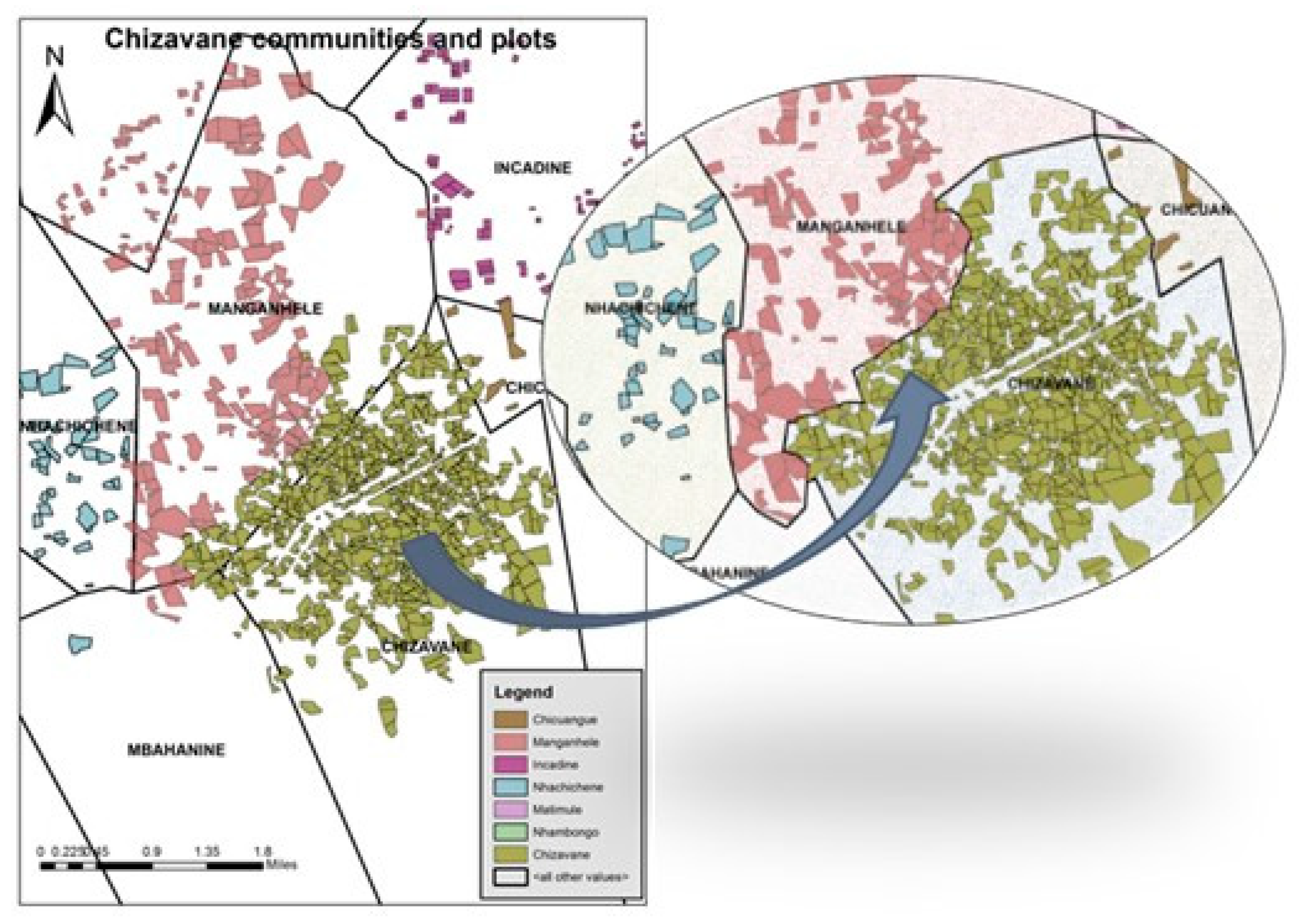
  • Three case studies were defined with an incremental level of difficulty: (i) a peri-urban area, where parcels followed an urbanization plan, and the limits of the parcels were visible; (ii) a community where parcel boundaries were not clear; and (iii) a cluster of communities with no clear boundaries both for individual parcels and communities.
  • The first case study involved 49 parcels, over a week, with a team of four people. The second case study involved 2500 parcels from two communities in two different provinces, during three months, with four teams of three people, two for community delimitations, and two for individual registrations. This was a complete coverage of the territories of these communities. The third case study involved a cluster of eight communities. In this case, the communities were delimited, but land registrations were performed in the center of the cluster, involving 820 parcels from three communities. One team of four people was dedicated to community delimitations, and three teams of three people were performing individual land registrations. The time horizon for this part of the research was cross-sectional [44,45], meaning that data from each of the case studies were collected quantitatively and qualitatively at a given moment, not over a long period. The patterns and differences between the different case studies were analyzed, providing improvements from one case study to the following [45].
Several techniques and procedures to collect and analyze data were utilized in this research, namely:
  • Semi-structured interviews surveys—to collect valuable information from experts of different thematic areas in an exploratory and descriptive manner. Interviews helped deepen the knowledge regarding the FFPLA approach and to answer “what”, “who”, “where”, “when”, “how” and “how much” questions [52] related to land administration processes. This part of the research supported the design of the conceptual model and guided the development of the FFPLA-MOZ approach.
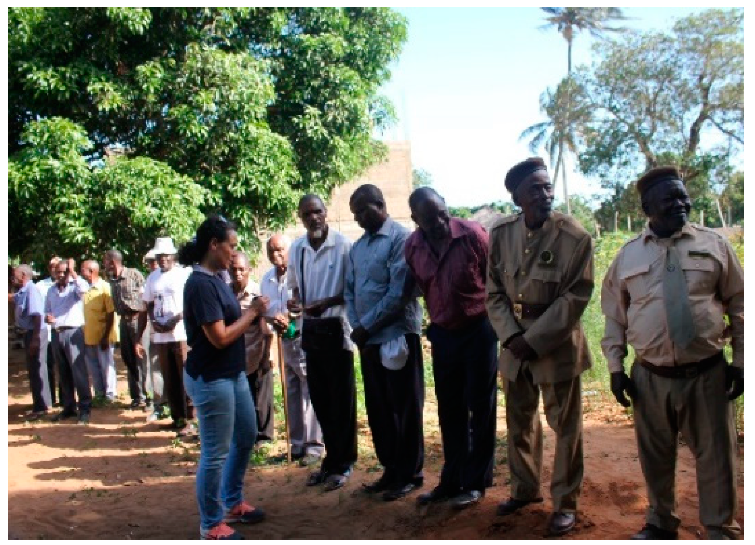
  • Participative observation—from the perspective of both an insider, as a participant, and an outsider, as an observer, to experience each of the case studies settings and further improve the approach based on reflections and learning process [53] throughout the active research period.
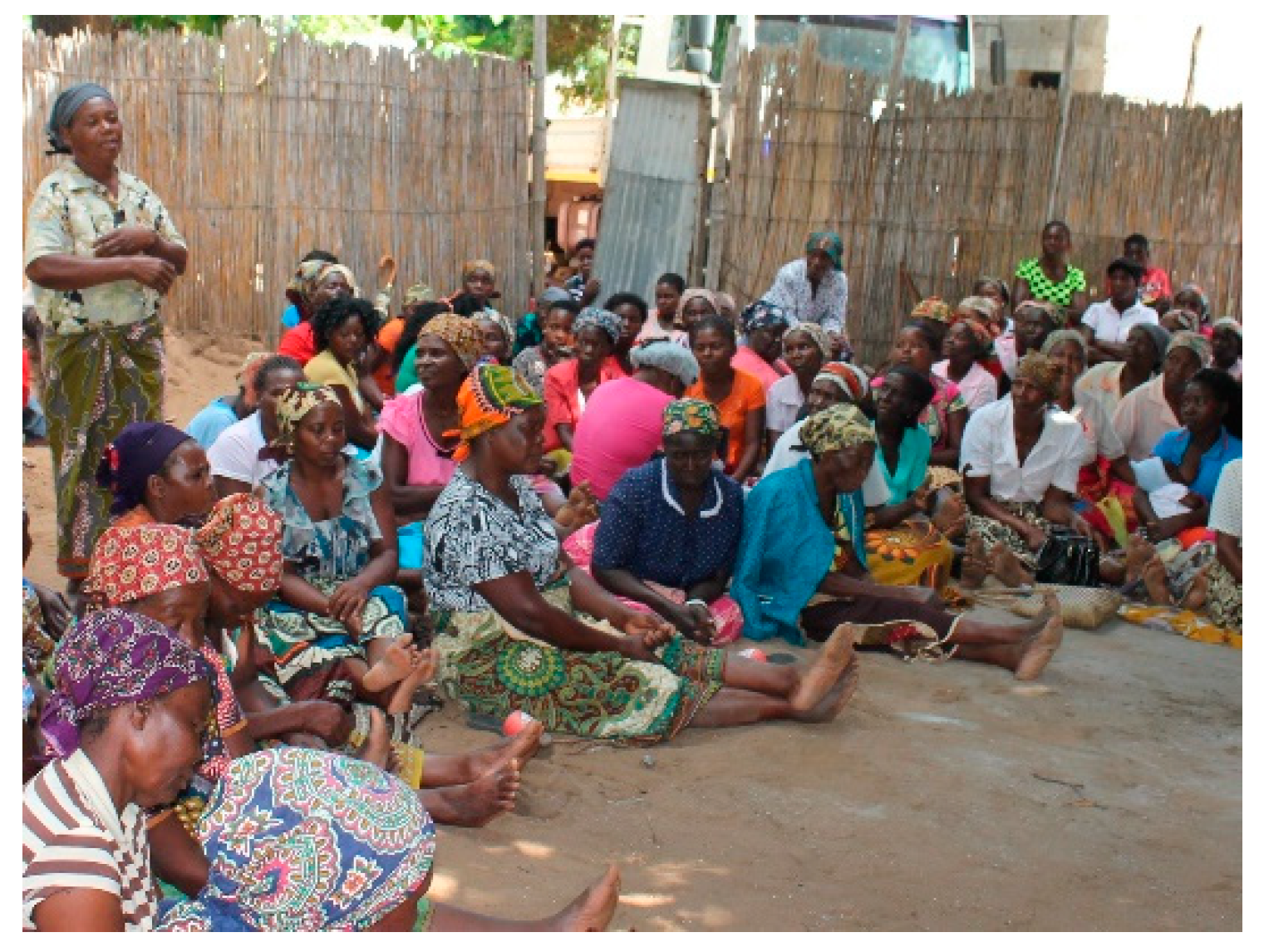
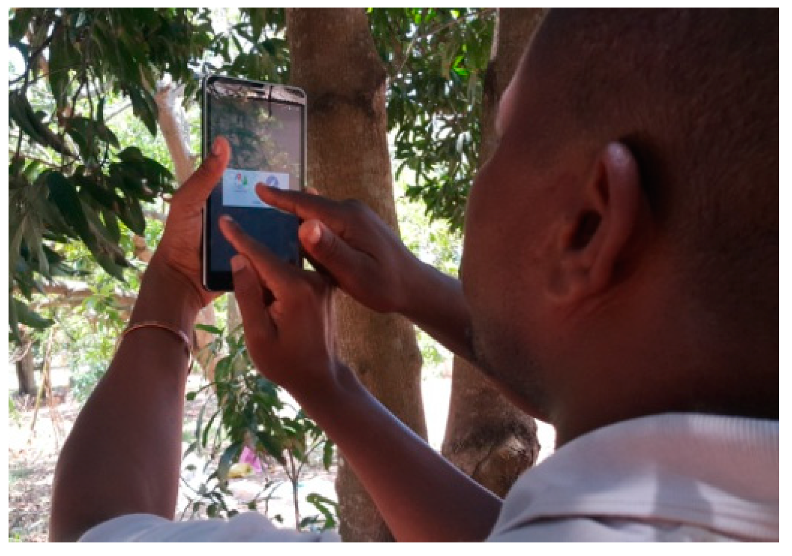
  • Questionnaire surveys to 3369 land tenants and 10 community councils—as part of the case study strategy—to collect data from a large number of respondents in a standardized and economical way, allowing easy comparison and validation of data [44]. Questionnaires were designed to collect data related to individual parcels and communal lands and data related to titleholders. These were implemented into a mobile application with embedded data quality and time processing controls. The data collected were inserted into a database which then provided reports and dashboards of the most crucial performance measurements such as rejection rates; the number of parcels registered per project, per day, per team; the number of parcels registered by gender and land use; and the number of hectares registered.
  • Questionnaire surveys to 24 end-users and 5 team managers of the mobile and cloud applications—to assess end-user satisfaction regarding the overall data quality, ease of use of the tools, and teams’ productivity. Qualitative data collected from these questionnaires were analyzed through descriptive statistical analysis.
  • The research also utilized data from secondary sources [44,45], such as online satellite imagery and maps from Google maps, to obtain images to support the registration process. The national land cadastre database was also consulted to check for existing parcels to avoid overlapping registered parcels.

2.2. Reference Frameworks

The research used the Fit For Purpose Land Administration (FFPLA) approach [24,30,31] as a reference framework and took into account the World Bank Land Governance Assessment Framework (LGAF) [54]. These frameworks were utilized in line with the country’s land legal and regulatory framework and having in mind the country’s context: a relatively large country with more than 80 percent of unregistered land occupations, specifically in rural areas; different typologies, cultures, and languages; difficult access to some remote areas; statutory laws, norms and customary practices, not well known, and sometimes in conflict with each other; high level of illiteracy; scarcity of skills and resources; limited access to internet connectivity; and limited access to high-resolution images [37,55].
The FFPLA guiding principles for country implementation [28] provided the principles and criteria relevant in the Mozambican context, primarily to design the spatial, legal, and institutional requirements. These guidelines also enhanced the need to include change management, capacity development, and project delivery [30] in the design of the managerial processes that would support the activities to “recognize”, “record”, and “review” land rights. “Recognize” involves a procedure for recognizing, classifying, and developing a typology in land rights based on an assessment of existing legitimate rights in the countryside. ”Record” means collecting data on evidence of land rights. “Review” means assessing the evidence of rights and any possible outstanding claims so that, when conditions are met, the security level of the rights will be increased [28].
The recent LGAF assessment [35] was helpful to provide insights from the current land governance practices, particularly the assessments made to land rights recognition, individual and communal lands regulations, public land management, land cadastre and public information, dispute resolution mechanisms, and institutional arrangements and policies.

2.3. Conceptual Model

The conceptual model for the FFPLA-MOZ approach was established through three intertwined pillars: People, Processes, and Technology (Figure 2):
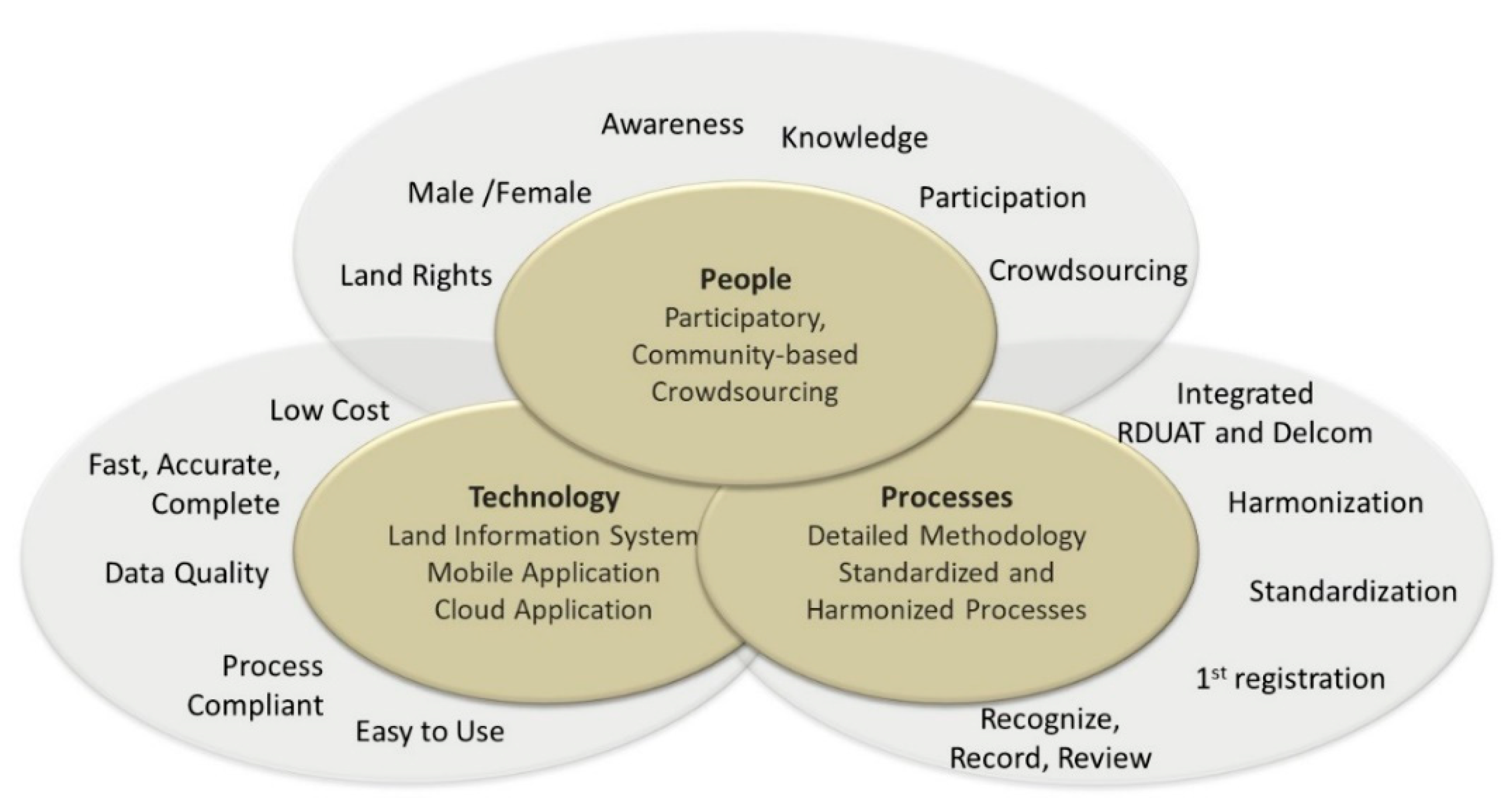
  • people or interested parties—to promote knowledge, awareness, and active participation of individuals and communities in the land registration. Apart from the participation of government agencies and services providers, active community engagement was advocated by several studies and frameworks [24,54,56,57,58]. Participatory land-use planning created a higher impact within the communities, increased ownership and satisfaction, and promoted a more sustainable land administration [59]. Crowdsourcing was also an essential approach for first registrations and maintenance of the land cadastres [58,60]. In this research, crowdsourcing was community-based in order to avoid land grabbing.
  • processes—to implement the rules of the game in a standardized manner. A comprehensive land registration set of processes and procedures, combining both managerial and operational processes (end-to-end), integrating the individual land registration (RDUAT6) and community delimitation (DELCOM7) processes. This was helpful to achieve several benefits, including (i) increased quality of work; (ii) reduction of costs, (iii) reduction of time; and (iv) more accurate and up-to-date information. Processes design respected the key principles of the spatial, legal, and institutional frameworks proposed by Enemark et al. [24].
  • innovative technology—to facilitate data acquisition and validation while working in the field, improve data quality, reduce time, and reduce work, errors, and rework costs. Innovative solutions had to be adequate to “recognize”, “record”, and “review” land rights cost-effectively. Solutions implemented in similar country contexts [61] proved to be effective to reduce costs [27,62,63,64] were also analyzed. The guiding principles for building land information systems for developing countries [65] were considered in the design and development of all technological innovations.
The FFPLA-MOZ approach was conceptualized, developed, and tested through several steps. First, the principles and criteria to be met were defined based on the conceptual model. Second, the processes, their respective activities and tasks, were defined and described in detail, integrating both RDUAT and DELCOM, harmonizing all processes and sub-processes, and creating a standard of work for any systematic land registration program. Third, the necessary tools were developed, respecting the designed processes. These tools were integrated with the existing LIMS (SiGIT). Fourth, tests were performed to validate the processes and the developed tools through three case studies in a continuous improvement cycle.

3. Results

3.1. The Mozambican Fit for Purpose Land Administration Approach

3.1.1. Principles and Criteria

The FFPLA-MOZ approach adopted the following criteria [66]:
Participation of citizensEnsure active community participation. The registration process started with a public meeting, with all groups and communities being represented. Together with the local community council, the objectives of the work and the way the work was to be executed were explained to the community. Because women and other vulnerable groups were usually the ones suffering the most insecurity of tenure [8], specific meetings were organized with these segments of the community so that everyone understood that their rights were to be recognized and recorded, following the motto “land rights for all, rich/poor, old/young, male/female” (Figure 3, Figure 4 and Figure 5). Sensitization sessions to promote gender equality and advocate land rights were held throughout the community, utilizing role-play sessions with different scenarios of land tenure inequalities. The training was given to community members selected to be part of the registration teams, including women, the elderly, and young people.
Inclusiveness—Registration must be systematic, covering the selected area, respecting existing registered parcels, contemplating only parcels under good-faith occupation or customary practices that comply with legitimacy criteria [67], ensuring that no one is left behind. The registration took into consideration the fact that there were existing parcels in the land cadastre. Illegal land grabbing or conflicts were excluded and were signaled as such. Parcels within protected areas were recorded for further action. Since the FFPLA-MOZ approach was tested through specific case studies, it was not possible to cover the entire area of a given community, with exception for the second case study that had specifically that purpose. The first and the third case studies only contemplated parts of the community land.
Adequate accuracy for public and community lands—Adopt flexibility based on the demands for accuracy depending on tenure types such as public lands, community lands, and protected areas. Ensure that scale and accuracy is sufficient for securing the various kinds of legal rights. Have different tenure forms recognized through the legal framework. Monumentation is not to be done. Where boundaries were clear, these were delineated over a map and later validated with the measurements taken with the GNSS8 system at known ground control points. This illustrated an accuracy of ±20 m, less than the ±30 m required by government regulations. In locations where the boundaries were fuzzy or dynamic (e.g., rivers), the proposal was to define a buffer [68]. Where the boundaries were not clear or were difficult to access, the proposal was to start with an initial sketch of the limits and wait for the results of the individual land registrations to delineate either a final limit or define a buffer. This was possible through an additional feature added to the mobile application, where each parcel received a name tag of the community to which it belonged. With this functionality, instead of geometrical straight lines defining the boundaries of the communities (a common practice being utilized before), boundaries could be more accurate respecting the parcels’ geographic location (Figure 6).
Adequate precision for individual land parcels—The purpose is to bring tenure security to customary and good-faith occupations. Accommodate a range of methods to measure and record parcel boundaries, including identifying visible boundaries on imagery. Individual parcels under good faith or customary occupations were recorded with precision under ±1.5 m. Beacons were not utilized to formalize the boundaries as monumentation was time-consuming, not consistently effective or respected, and it delayed the process of land recordation and registration. Community leaders recommended utilizing “live” monuments such as trees planted at the vertices of the parcel.
Reliability—Ensure technology captures spatial and administrative data with quality controls capturing people to land relationships. Ensure community participation, with solid social preparation, to increase the reliability of the entire process. People to land relationship was collected through the mobile application, seeking alphanumeric data of tenants, administrative data of land uses, as well as geographic data of the parcel (Figure 7). The mobile application was adjusted to collect alphanumeric and geographic information in the same form. The application included quality controls, image capturing of documents, and information regarding the local authority’s validation (Figure 8). Only complete and validated forms were uploaded to the cloud. Tenants’ data could be shared between teams using a feature created in the mobile application. Parcels that were rejected afterwards were sent back to the team, indicating the error to be corrected.
Update or ability to be updated—Consider opportunities for ongoing updating, sporadic upgrading, and incremental improvement of the land information whenever relevant or necessary for fulfilling land policy aims and objectives. In the last case study, apart from the new registrations, there was a need to update 150 parcels registered previously in a different initiative. These updates were needed for the following reasons: (i) inclusion of additional tenants, after sensitization of the community with regards to gender equity; (ii) adjustment of boundaries to resolve detected conflicts; (iii) adjustment of boundaries where the parcels infringed protected areas; and (iv) disaggregation of a parcel to contemplate several other parcels.
Digital services: flexibility in the technological solutions—Adopt an effective, scalable, sustainable, and secure land information system, in an incremental approach, as this is more sustainable than other more ambitious, faster implementations [30,31], primarily oriented to more developed economies. Although the ultimate technological solutions were sophisticated and supported the most innovative features, the FFPLA-MOZ solutions were relatively simple to accommodate the limitations of the Information and Communication Technology (ICT) infrastructure and shortage of skills. Flexibility in the technological solutions was implemented through a series of innovations, described in detail in Section 3.1.3 and Section 3.2.2.

3.1.2. Integrated and Harmonized Processes

The processes were defined with the participation of different stakeholders from the Government, civil society, NGOs9, service providers, and experts from the different subject areas. All processes, their respective activities and tasks, were harmonized, integrating both individual registrations and community delimitations, resulting in a set of guidelines and norms. Efforts were made to ensure that these processes would also be Fit For the Future. This component of the FFPLA-MOZ was comprised of a Process Wheel, a Process Orchestration Diagram, and several Context Diagrams:
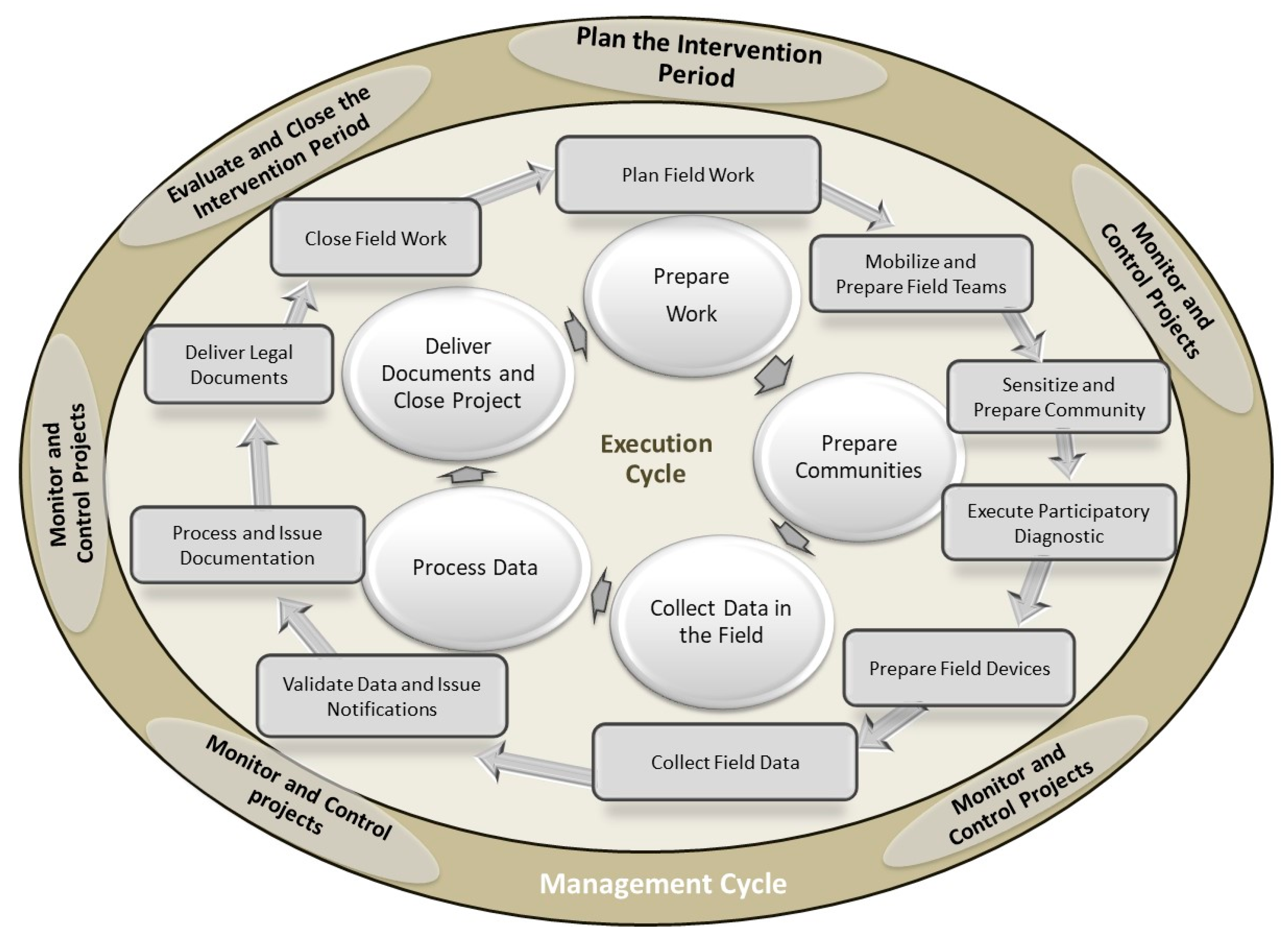
  • The Process Wheel (Figure 9) consisted of two main cycles: a managerial cycle in an outer circle and an execution cycle in an inner circle. The managerial cycle comprised three management processes: planning the period, monitoring and controlling all RDUAT/DELCOM projects, and evaluating the period. This outer cycle ran within a specific period, generally defined as a year. The execution process was performed in a cycle of a shorter duration for every RDUAT/DELCOM project. The inner cycle was comprised of five subprocesses: Prepare the Field Work, Prepare Communities, Collect Data in the Field, Process Data, Deliver Documents, and Close Project.
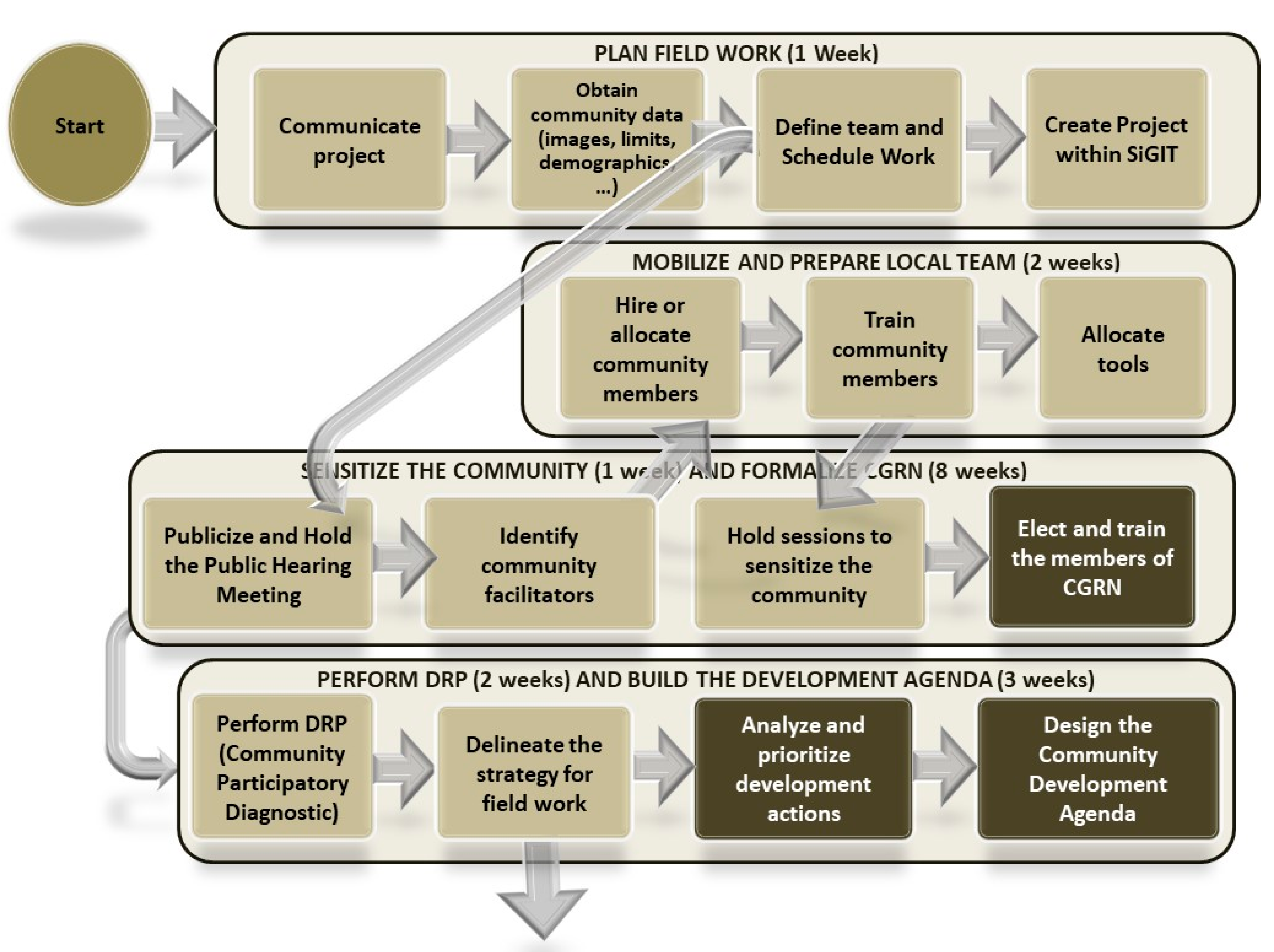
  • The Process Orchestration Diagrams (Figure 10) illustrated all the processes, subprocesses, respective activities, and their sequence of execution, which supported the configuration of the workflows within the applications. It was an important tool to visualize those specific or common activities both to individual registrations and community delimitations, and therefore could be harmonized. In Figure 10, for example, the activities with white text font were only performed for community delimitations. These were to be completed in a later stage of the registration, outside the scope of this research.
  • The Context Diagram described each of the processes embedded in the FFPLA-MOZ approach in greater detail. The Context Diagrams were designed uniformly to create a norm for utilization, facilitating monitoring and control. Each process was described in terms of Goals and Objectives, Activities and Tasks, Techniques, Roles and Responsibilities, Inputs and Outputs, Metrics, as well as Risks and Mitigation measures.

3.1.3. Technology Innovation

Technology innovation was deemed essential to accelerate data collection, reduce costs and errors, increase data quality, and enhance community participation, provided it was accessible, cost-effective, and less skill demanding. Technology innovations were under the responsibility of the LIMS developer, a local company that had been supporting the operation of SiGIT since its implementation [69]. Innovation was achieved through three main activities:
First, the land information system—SiGIT—was adjusted to accommodate new and redesigned business processes, especially those related to good-faith and customary occupations and community delimitations. The system incorporated all land-related legislation, regulations, and policies into its workflows for all land administration processes from registration to taxation, expansion or reduction of area, transmission of rights, revocation or cancellation of rights (Figure 11). This adjustment also differentiated workflows for urban and rural areas. SiGIT was also changed to allow delimitations and individual registrations to co-exist within the same spatial project area and combine several activities within the same registration project. The interoperability between the SiGIT back-office application and the mobile and cloud applications (SiGIT mobile and SiGIT Cloud) was built, with several data quality controls in all data exchange interfaces. New analytics reports for the monitoring and control processes were created. The data model chosen for the SiGIT system was based on the ISO 19152:2012—Land Administration Domain Model (LADM) [70]. No changes were made to the systems architecture nor to the base technology. All the changes to the SiGIT system followed the change management procedure in place.
Second, the mobile application—SiGIT mobile—was developed to contemplate the FFPLA-MOZ processes’ requirements. It provided a user-friendly interface that would speed up collecting field data, easy to utilize both by surveyors and non-surveyors, including community members. The mobile application was developed with its database, which allowed to structure data and reuse objects that were previously collected in the field (parcel holders, documents, parcels), resulting in increased efficiency. The mobile application provided four methods of spatial data capture: (i) embedded mobile device GNSS (adequate for community delimitations); (ii) drawing the parcel on a map (adequate when images were clear and with good precision); (iii) pairing the mobile application with a GNSS device; and (iv) entering coordinates manually. It also included spatial data libraries to provide several spatial functions for data validation, manipulation, quality control, and the ability to work with offline maps, enhancing flexibility to work both alphanumeric and spatial data.
Finally, a cloud module—SiGIT Cloud—was developed to capture data from the fieldwork, pre-process data, and send data to the SiGIT application (or back to the mobile application in case of errors). This module was available to service providers and required the surveyor’s expertise. It controlled the quality of work of specific teams and individuals through specific performance dashboards.
The development of the mobile and cloud applications utilized agile development methodologies, open-source technologies and libraries from the Open Geospatial Consortium and Open Street Maps, both for the alphanumeric and geographic components.

3.2. Improvements

3.2.1. Improvements through Integrated and Harmonized Processes

The harmonization between RDUAT and DELCOM allowed the combination and integration of processes and activities, which resulted in several benefits:
  • Reduced total time per project: initially, a complete delimitation took around nine months, whilst with the new integrated and harmonized processes, the work was completed in five months, including individual land registrations within the community.
  • Reduced overall program budget: after integrating individual registrations and community delimitations, recalculations of the “Terra Segura” program budget illustrated a reduction by 30 percent, just by optimizing and combining resources and activities.
  • Reduced malpractices: adopting a uniform way to perform the work reinforced each participating role in the land administration and increased clarity on what to do, how to do, when to do it, thus promoting a more sustainable process-based approach to land administration.

3.2.2. Improvements through Technology Innovation

Data captured in the field through the mobile application were uploaded to the cloud and downloaded to the SiGIT application from the cloud. A team dedicated to quality control performed all the necessary checks to determine data rejection rates and team productivity. Comparisons were made between analogue (paper-based forms) and digital mobile data capturing methods regarding the following: rejection rates; time to collect, validate and process field data; types of errors encountered; compliance of the tool with the data quality requirements. Comparisons were also made between the different geographic data capture methods. Questionnaires were given to field workers utilizing these tools to determine their level of satisfaction and their recommendations to improve the tools. The following results were achieved:
  • Increased performance: implementing the SiGIT mobile application and its integration with both the cloud and the back-office system resulted in several optimizations. Data collection, validation, and processing time for individual registrations reduced from 35 to 18 min (alphanumeric data) and from 21 to 6 min (geographic data). The amount of time varied according to the number of people that needed to be registered for each parcel and if walking around the parcel boundary was required. Rejection rates dropped from 44 percent to 1 percent, and possible types of errors reduced from 16 to 3.
  • Reduced costs: the costs of community delimitations when in a cluster were reduced by 60 percent, and systematic individual parcel registrations were reduced by 70 percent. Within this research, the cost of registering the individual parcels was 15 USD, and to delimitate a community was 2.000 USD. These reductions were achieved through a combination of processes and technology improvements. These costs did not include imagery acquisition as free images were utilized and georeferenced. It also did not include the design of community development agendas to manage natural resources, as this activity was not part of this research.
  • Flexibility and accuracy of geographic information: with the SiGIT mobile application, the flexibility of capturing geospatial information was increased as four methods were simultaneously available for geographic information data collection. The decision of which method to utilize significantly depended on the working conditions of the area and the availability of adequate imagery. Overall, the utilization of the android GNSS was simple. Still, the precision was not adequate (precision varied from ±3 m to an average of ±10 m but in some cases going over ±18 m). The second method, the ability to draw the parcels over a map, proved to be a simpler and faster data collection procedure. Google Maps that were freely available were georeferenced using a GNSS and ground control points visible both on the map and in the field. This method had a drawback in situations where the boundaries were not clear or the quality of the image was poor. In the cases where good quality images were utilized, the method achieved ±0.52 m precision. In situations where the boundaries of a parcel were not clear on the image, functionality was added to the mobile application that permitted the user to walk around the parcel collecting geographic data. The third method utilized a differential GNSS connected via Bluetooth to the mobile application. This method achieved the best precision (±0.32 m) but was the most expensive method and required a professional surveyor to operate the GNSS. The fourth method was used when the differential GNSS could not interconnect with the mobile application.
  • Increased control of team’s performance: one of the problems from previous exercises was the lack of information regarding teams’ performance during fieldwork and afterwards. Performance control was a requirement both from service providers and the Government. The cloud application provided a dashboard with several indicators that helped to correct several bottlenecks throughout the workflow.
  • Increased end-user satisfaction: all field users indicated that the mobile application was easy to use and navigate, with straightforward questions. They also indicated that the spatial component embedded in the mobile application was a substantial value-added. They complained that the mobile application mandated filling in information previously skipped in paper forms. All office users and quality controllers indicated their workload reduced considerably as all data were automatically uploaded and checked. They also indicated that the number of rejections and re-works was minimum and that the dashboards were helpful to control teamwork and project completion rates.

4. Discussion

The FFPLA-MOZ approach demonstrated that it is possible to reduce complexity, time, and costs, increase efficiency, as well as work quality and data quality. This was achieved through a series of improvements at each test interaction. In this section, the three pillars of the conceptual model of the FFPLA-MOZ approach are discussed: People, Processes, and Technology.

4.1. People: Awareness, Engagement, and Participation

The case studies illustrated that most people were not aware of their rights, and in some situations, the customary practices infringed the statutory law promoting gender inequalities.
The role-play training adopted for sensitization regarding gender equality and vulnerable groups’ protection proved to be highly effective to illustrate land rights and land tenure security for all. Overall, in this research, the percentage of parcels belonging to women increased to 42 percent instead of 20 percent that was the average before the research started [38,71]. More recent statistics from the “Terra Segura “program indicated that the percentage of parcels belonging to women reached 56 percent in 2020 (Figure 12). However, this subject requires further investigation as land tenure equality is both for men and women, and therefore co-titling should also be promoted.
It was clear that, in a more participatory engagement of the community (the third case study with community-based crowdsourcing), the work progressed somehow at a slower pace in the beginning but then achieved the same pace as if private surveyors would be doing the registration. Private surveyors still needed to be present to provide training, guide and supervise the work, control the quality of data collected, and help communities be familiar with the instruments of work, either the mobile application or the printed images of the community area. Communities responded well to the interpretation of printed maps, which helped define their boundaries in the cluster. The third case study was the case that observed more engagement and appropriation from community members, resulting in an increased level of confidence in the information collected and reduced overall costs. However, this more participatory engagement was only possible due to the utilization of mobile technology that was easy to use coupled with imagery with enough resolution to identify the spatial boundaries of community land and individual parcels.
To support the work of the community team, the community organized the payment of a small fee (around 1 USD per parcel), as a contribution from each household being registered, which ended up generating a lot of engagement from all selected team members and contributed to the smooth execution of the fieldwork. It also generated a precious income both to the older people and the young team members working in the field, usually unemployed [69]. This was a new approach as usually service providers contracted community members to participate in the registration process.
Some drawbacks were noted. During the public announcement meeting, it was explained to everyone the study would only include registrations in the center part of the cluster. Those that were not contemplated felt left behind and hoped that the process would continue afterwards. Additionally, some beneficiaries did not receive the individual parcels titles due to the unavailability of the SiGIT operations from the beginning of 2020, which constituted a setback in the engagement achieved during the fieldwork.

4.2. Processes: Integration and Harmonization

The research design was adequate to explore, describe and explain the working processes, and implement quality improvements at each new cycle of interactions.
By integrating individual registrations and community delimitations, it was possible to reduce redundant work, time and costs, and increase community satisfaction and willingness to participate in the registration process. Previously, before integrating these processes, communities complained about their individual lands being left out of the delimitation process or vice versa. The active participation enhanced overall land administration and produced more accurate and complete data. Additionally, communities understood the value of their land and how to manage it accordingly and understood the purpose of land registrations as a mechanism to reduce conflicts and avoid land grabbing.
Using clusters of communities helped define the boundaries of all communities belonging to the cluster, all at once, reducing time and costs. The amount of work was further reduced when the mobile application embedded functionality to tag each parcel with details of its community. Subsequently, when all parcels were uploaded into the cloud application, it was possible to utilize the individual parcel registrations located on the borderlines of the communities, utilizing different colors to represent each community, to delineate the boundaries in a more precise manner. This solution required that some activities change their execution order: community delimitations started with initial sketches, but final delimitations were only performed after all individual parcels had been registered. With this solution, it was possible to reduce the amount of work and time to delimitate communities.
One additional improvement to be implemented in the future is the creation of interoperability with other cadastres. Observations indicated that it took at least 5 min to capture information from each tenant (biography, pictures of documents), which was time-consuming, especially when several people were to be registered as co-tenants [72]. This could be solved through the interoperability with upstream cadastres such as the identity cadastres10. It was also recommended the interoperability with downstream cadastres that provide information to support the development agendas of communities such as mining concessions and forestry concessions.
Another important issue considered was the fact that cadastral information became quickly outdated, as illustrated in the third case study. Updating and maintaining cadastral data referred to the need for registers to be trustable and reflecting the actual spatial and legal/legitimate situation on the ground, while upgrading related to improving the accuracy for specific purposes, more generally to meeting societal needs. It became evident the need for appropriate processes and tools to be designed, developed, and implemented—preferably at the community level—to ignite the required updates when and where they occur. An initial solution to resolve this constraint was the implementation of a basic community-based land cadastre [73], providing communities with a dossier that included (i) all parcels registered within the community, with specific sections for updates (amendments); (ii) a map with all the registered parcels within the community; and (iii) a map with the community boundaries. This dossier was delivered to the community council and was available for public consultation. Subsequently, there was a recommendation to improve the mobile application with functionality to automate this dossier and to register requests for updates. Another recommendation, perhaps a more difficult one to implement, was to entitle the community with the authorization competence and power to formalize land rights for smaller parcels under good faith and customary occupations.
Within the “Terra Segura” program, the issue of monitoring and control proposed by the FFPLA-MOZ is still to be resolved. The Government did not yet manage to create a specific unit dedicated to this aspect due to the lack of funds to contract specialists and establish that function. Lack of funds also contributed to a reduced number of registration projects and the cancellation of others. Up to March 2020, a total of 826 community delimitations and 1,375,586 individual parcels had been processed by the SiGIT land cadastre. From then on, 220,805 parcels and 606 communities remain to be migrated to the system. This illustrates that, although there was an increased number of parcels registered and communities delimited, there were bottlenecks to be resolved, including funding. The involvement of the World Bank as a financer should resolve part of the funding problem.

4.3. Technology: Innovations to Improve Digital Services

The tools developed specifically for this research were based on the Mozambican context and the FFPLA-MOZ processes requirements. They were improved and fine-tuned through several adjustments that would not have been easy to implement if an off-the-shelf tool had been selected. The innovations were evaluated in light of the recommendations for a successful land information system implementation, namely: sustainability, security, and scalability [74]:
Sustainability: Achieved through user capacity and ability to implement new requirements, cultural changes, integration of data, provision of online services, increased revenue generation, stakeholder support. This was the dimension facing more threats during the research. The training was given to all end-users, contemplating government officials, service providers, and community members. There was recognized competence to utilize the tools throughout the country. Online supporting services and a service desk unit were created to support all internal and external users. Data integration within all stages of the registration process was accomplished through specific automated software, and those operating with the SiGIT mobile application could see their work immediately integrated into the land cadastre. However, there were insufficient expertise and ICT skills within the Government, which implicated that the ICT services, including the SiGIT application lifecycle management, were outsourced. Meanwhile, these contracts were cancelled due to insufficient funds. Similar constraints were observed in other countries [75]. For any systematic registration to succeed, the ICT infrastructure, including the application, cannot be the bottleneck. The Government must monitor and control aspects of the registration and leave both the registration projects and the ICT maintenance and support to specialized companies.
Scalability: Achieved through a phased approach implementation of business rules and processes, innovation to comply with legislative changes and new business requirements, integration, and interoperability between systems. SiGIT was initially built for the daily operations of a provincial land office and therefore did not contemplate the requirements for massive land registration programs, both in terms of software application and ICT infrastructure. The Government implemented an upgrade to the ICT infrastructure. Several new modules and additional functionality were developed into the SiGIT application, creating more robust and reliable services. These newer versions of SiGIT were released in a phased approach, based on the established priorities. All users agreed that the newer versions and upgrades delivered additional value and facilitated their activities. They also indicated that the interactive user manuals were a significant gain for speeding up the learning process. The incremental phased approach proved to work well. The existing solutions were improved throughout the research. Over time, they can be further enhanced to embed new technology and create greater functionality, given that more effective resources are available and maturity levels in utilizing these solutions have increased.
Security: Achieved through security access, security of data, ICT policies, and the guarantee of business continuity in case of disasters. The ICT infrastructure was upgraded to increase security. Synchronization mechanisms from mobile to cloud to provincial to the central database were created with increased security through encryption mechanisms. Secure access protocols and views to SiGIT data were implemented for service providers’ external access. However, there were severe constraints in terms of communications as well as data center operations. There was a need to improve the security policy and the business continuity policy, and recommendations were given to the Government for that purpose.

5. Conclusions and Recommendations

By adopting the FFPLA-MOZ approach, three pillars—people, processes, and technology—were connected, resulting in several improvements in the systematic land registration. This was possible because (i) all processes were harmonized, integrating both individual registrations and community delimitations, resulting in a set of guidelines and norms which increased quality of work and reduced costs and time; (ii) community active participation enhanced overall land administration and produced more accurate and complete data; (iii) technology was affordable, easy to use, and was fit to accelerate data collection and processing, respecting all defined working processes.
Community-based crowdsourcing was effective for collecting and recording data so that the community itself organized the data collection, which was then submitted for subsequent data processing. This solution presented limitations unless (a) services providers were willing to prepare and engage the community in more tasks; (b) community land cadastres were integrated into the national land cadastre; (c) there were means to keep alive the interaction between the community and the government land offices; and (d) the tools that were developed for field data collection, updates, and consultation, were fit for community usage.
Gender equity is an essential aspect of land tenure security. Several strategies were tested to ensure tenure security for women and other vulnerable groups with positive outcomes, such as role-play training with real case scenarios of land tenure inequalities and selecting women to participate in the registration process. Meeting separately with women and other vulnerable groups also proved to work better to disseminate land rights. These approaches need to be further improved and included in the sensitization activities of any systematic registration.
Within this research, the FFPLA-MOZ provided both the Government, communities, and individuals with accurate and up-to-date information regarding land use and land rights of the communities. The approach can be launched nationwide to help create an effective and sustainable land administration, support security of tenure, reduce conflicts, and avoid land grabbing. This requires that all stakeholders must appropriate it at strategic, tactical, and operational levels. There is also a need to redistribute competencies and capabilities within the institutions in charge of the cadastre services. Since these land registration initiatives are usually complex, they require strong leadership, change management, project delivery, capacity building, and sufficient funds. Therefore, tangible and intangible costs and benefits need to be considered when evaluating the affordability and sustainability of such initiatives.

Author Contributions

Conceptualization M.B. and J.C. and C.L.; methodology, M.B.; software development, M.B.; fieldwork M.B.; analysis, M.B. and J.C. and C.L.; writing—original draft preparation, M.B.; writing—review and editing, M.B. and J.C. and C.L.; funding acquisition—fieldwork, M.B.; funding acquisition—publishing, C.L. All authors have read and agreed to the published version of the manuscript.

Funding

Funding for the development of the technology innovations was kindly provided by EXI Lda, a local private company responsible for the lifecycle management of the SiGIT, the Land Information Management System in Mozambique. Funding of the publication costs for this article has kindly been provided by the School of Land Administration Studies, University of Twente, in combination with Kadaster International, the Netherlands.

Institutional Review Board Statement

Not applicable.

Informed Consent Statement

Not applicable.

Data Availability Statement

All the data that was collected is part of the Mozambican Land Cadastre.

Acknowledgments

The authors would like to thank the communities involved in the case studies, namely the communities from Marracuene, Gurue, Malema and Chizavane. Special thanks to Simão Joaquim, José Almeirim de Carvalho, and Daniel Queface from the National Directorate of Land. The authors would also like to acknowledge the contributions of service providers such as ITC, Verde Azul, Topmap, and Atopocomé for their valuable contributions during the tests of the FFPLA-MOZ approach. Special thanks to Kadaster International for the valuable clarifications with regards to the FFPLA approach. Special thanks to Enzo Scarcella, from the Africa Leadership Initiative-South Africa, for providing the tablets for the fieldwork. Last but not least, special thanks to EXI and the SiGIT team for all the efforts to implement the required innovations.

Conflicts of Interest

The authors declare no conflict of interest. The funders had no role in the study’s design; in the collection, analyses, or interpretation of data; in the writing of the manuscript, or in the decision to publish the results.

Notes

1
UNDP—United Nations Development Program
2
HDI—Human Development Index
3
Also known as GINI index, measures the extent to which the distribution of income (or, in some cases, consumption expenditure) among individuals or households within an economy deviates from a perfectly equal distribution.
4
SiGIT—Sistema de Gestão de Informação sobre Terras (Land Information Management System)
5
PDCA = Plan, Do, Check and Act.
6
RDUAT—Regularização do Direito de Uso e Aproveitamento da Terra (in English: Land Tenure Regularization). Good faith occupations and customary tenure are recognized by law, but do not require registration and titling. RDUAT is a formalization of this recognition, by recording and reviewing data regarding tenant’s and parcel’s data.
7
DELCOM—Delimitação Comunitária (in English: Community Delimitation). Community rights are recognized in the law. The process of delimitating communities envisages recognizing, recording and reviewing these rights, followed by a general community land use agenda.
8
GNSS—Global Navigation Satellite System
9
Non-Governmental Organizations
10
Identity cadastres such as the ID Card database, the electorate registration database, or the driving license database, contain biographic information such as name, date of birth, place of birth, filliation, marital status.

References

  1. UN-Habitat. Women and Land in the Muslim World: Pathways to Increase access to Land for the Realization of Development, Peace and Human Rights; UNHabitat: Nairobi, Kenya, 2018. [Google Scholar]
  2. Enemark, S.; Bell, K.C.; Lemmen, C.; McLaren, R. Fit-For-Purpose Land Administration. FIG Publication No 60. Joint Publication; International Federation of Surveyors (FIG), World Bank: Copenhagen, Denmark, 2014. [Google Scholar]
  3. ILC. Women’s Land Rights; International Land Coalition: Rome, Italy, 2019. [Google Scholar]
  4. Singirankabo, U.A.; Ertsen, M.W. Relations between land tenure security and agricultural productivity: Exploring the effect of land registration. Land 2020, 9, 138. [Google Scholar] [CrossRef]
  5. Daley, E.; Englert, B. Securing land rights for women. J. East. Afr. Stud. 2010, 4, 91–113. [Google Scholar] [CrossRef]
  6. Daniel Ayalew, A.; Deininger, K.; Goldstein, M. Environmental and Gender Impacts of Land Tenure Regularization in Africa: Pilot Evidence from Rwanda; Africa Region Gender Practice Policy Brief, World Bank: Washington, DC, USA, 2011. [Google Scholar]
  7. Odeny, M. Improving Access to Land and strengthening Women’s land rights in Africa. In Proceedings of the Annual World Bank Conference on Land and Poverty, Washington, DC, USA, 8–11 April 2013; p. 16. [Google Scholar]
  8. Yngstrom, I. Women, wives and land rights in Africa: Situating gender beyond the household in the debate over land policy and changing tenure systems. Oxf. Dev. Stud. 2002, 30, 21–40. [Google Scholar] [CrossRef]
  9. De Soto, H. The Mistery of Capital—Why Capitalism Triumphs in the West and Fails Everywhere Else; Black Swan: London, UK, 2001. [Google Scholar]
  10. Payne, G.; Durand-Lasserve, A.; Rakodi, C. The limits of land titling and home ownership. Environ. Urban. 2009, 21, 443–462. [Google Scholar] [CrossRef]
  11. Deininger, K. Towards sustainable systems of land administration: Recent evidence and challenges for Africa. Af. JARE 2010, 5, 205–226. [Google Scholar]
  12. UN General Assembly. Transforming our world: The 2030 Agenda for Sustainable Development. Available online: https://sdgs.un.org/2030agenda (accessed on 25 April 2021).
  13. Musinguzi, M.; Enemark, S. A Fit-For-Purpose Approach to Land Administration in Africa—supporting the 2030 Global Agenda. Int. J. Technoscience Dev. 2019, 4, 69–89. [Google Scholar]
  14. International Land Coalition. The International Land Coalition and Sustainable Development Goals Working Together to Realise Land Governance; International Land Coalition: Rome, Italy, 2018. [Google Scholar]
  15. ActionAid International. Securing Women’s Right to Land and Livelihoods a Key to Ending Hunger and Fighting AIDS; ActionAid International: Johannesburg, South Africa, 2008. [Google Scholar]
  16. FAO. Land Access in Rural Africa: Strategies to Fight Gender Inequality; FAO: Rome, Italy, 2008. [Google Scholar]
  17. Chigbu, U.E.; Paradza, G.; Dachaga, W. Differentiations in women’s land tenure experiences: Implications for women’s land access and tenure security in sub-saharan Africa. Land 2019, 8, 22. [Google Scholar] [CrossRef] [Green Version]
  18. Haldrup, K. Mainstreaming Gender Issues in Land Administration: Awareness, Attention and Action. In Proceedings of the FIG XXII International Congress—Washington DC, Washington, DC, USA, 19–26 April 2002. [Google Scholar]
  19. Agarwal, B. Gender equality, food security and the sustainable development goals. Curr. Opin. Environ. Sustain. 2018, 34, 26–32. [Google Scholar] [CrossRef]
  20. Daley, E.; Flower, C.; Miggiano, L.; Pallas, S. Women’s Land Rights and Gender Justice in Land Governance: Pillars in the Promotion and Protection of Women’s Human Rights in Rural Areas; International Land Coalition: Rome, Italy, 2013. [Google Scholar]
  21. FAO. Improving gender equity in access to land. In FAO Land Tenure Notes 2; FAO: Rome, Italy, 2006. [Google Scholar]
  22. FAO. Governing Land for Women and Men—A Technical Guide to Support the Achievement of Responsible Gender-Equitable Governance of Land Tenure. A technical Guide to Governance of Land Tenure; FAO: Rome, Italy, 2013; p. 120. [Google Scholar]
  23. McLaren, R.; Enemark, S. Fit-For-Purpose Land Administration: Developing Country Specific Strategies for Implementation. In Proceedings of the Responsible Land Governance: Towards an Evidence Based Approach: World Bank Conference on Land and Poverty, Washington, DC, USA, 20–24 March 2017. [Google Scholar]
  24. Enemark, S.; McLaren, R.; Lemmen, C. Fit-For-Purpose Land Administration Guiding Principles; Global Land Tool Network (GLTN): Copenhagen, Denmark, 2015. [Google Scholar]
  25. de Zeeuw, K.; Dijkstra, P.; Lemmen, C.; Unger, E.-M.; Molendijk, M.; Oosterbroek, E.-P.; van den Berg, C. Bridging the Security of Tenure Gap: Fit-For-Purpose Initiatives. In Proceedings of the FIG Working Week 2019 Geospatial Information for a Smarter Life and Environmental Resilience, Hanoi, Vietnam, 22–26 April 2019. [Google Scholar]
  26. Morales, J.; Lemmen, C.; De By, R.; Molendijk, M.; Oosterbroek, E.-P.; Ortiz Dávila, A.E. On the Design of a Modern and Generic Approach to Land Registration: The Colombia Experience. In Proceedings of the 8th International FIG Workshop on the Land Administration Domain Model, Kuala Lumpur, Malaysia, 1–3 October 2019; pp. 217–242. [Google Scholar]
  27. Mekking, S.; Kougblenou, D.V.; Kossou, F.G. Fit-For-Purpose Upscaling Land Administration—A Case Study from Benin. Land 2021, 10, 440. [Google Scholar] [CrossRef]
  28. GLTN, UN-Habitat. Fit-For-Purpose Land Administration Guiding Principles for Country Implementation; Global Land Tool Network (GLTN): Copenhagen, Denmark, 2016. [Google Scholar]
  29. Enemark, S. Fit-for-purpose land administration for sustainable development. GIM Int. 2016, 30, 16–19. [Google Scholar]
  30. McLaren, R.; Enemark, S.; Lemmen, C. Guiding Principles For Building Fit-For-Purpose Land Administration Systems in Developing Countries: Capacity Development, Change Management and Project Delivery. In Proceedings of the 2016 World Bank Conference on Land and Poverty, Washington, DC, USA, 14–18 March 2016. [Google Scholar]
  31. Lemmen, C.; Enemark, S.; McLaren, R.; Antonio, D.; Gitau, J.; Dijkstra, P.; De Zeeuw, C. Guiding Principles for Building Fit-For-Purpose Land Administration Systems in Less Developed Countries: Providing Secure Tenure for All. In Proceedings of the 2016 World Bank Conference on Land and Poverty, Washington, DC, USA, 14–18 March 2016. [Google Scholar]
  32. INE. Annual Statistics. Maputo—Moçambique. Available online: http://www.ine.gov.mz/ (accessed on 31 May 2021).
  33. Government of Mozambique. Voluntary National Review of Agenda 2030 for Sustainable Development; Government of Mozambique: Maputo, Mozambique, 2020.
  34. UNDP. Human Development Report 2020—The Next Frontier Human Development and the Anthropocene; UNDP: New York, NY, USA, 2020. [Google Scholar]
  35. DINAT. Avaliação da Governação de Terras—Land Governance Assessment—Mozambique, Based on the WorldBank LGAF Framework; DINAT: Maputo, Mozambique, 2017. [Google Scholar]
  36. De Carvalho, J.A. Balanço dos Registos de Terras Activos no SiGIT—Internal Report DINAT; 2018; Unpublished. [Google Scholar]
  37. Balas, M.; Carrilho, J.; Pascoal, T.; Queface, D.; Carimo, R.; Pinheiro, A. Secured Land tenure Program in Mozambique—A Fit For Purpose Approach. In Proceedings of the 2016 World Bank Conference on Land and Poverty—Scalling up Responsible Land Governance, Washington, DC, USA, 14–18 March 2016. [Google Scholar]
  38. DNTF. Estudo de Auditoria Social e de Género na Gestão e Administração de Terras; DINAT: Maputo, Mozambique, 2014. [Google Scholar]
  39. Larsson, G. Land Registration and Cadastral Systems: Tools for Land Information Management; John Wiley and Sons Inc.: Hoboken, NJ, USA, 1991; Available online: https://search.library.uq.edu.au/primo-explore/fulldisplay?vid=61UQ&docid=61UQ_ALMA2180440060003131&lang=en_US&context=L&query=browse_subject,exact,environmental%20sciences%20%23fast&sortby=title&mode=browse (accessed on 25 April 2021).
  40. Hanstad, T. Designing Land Registration Systems for Developing Countries. Am. Univ. Int. Law Rev. 1998, 13, 647–703. [Google Scholar]
  41. Dale, P.; McLaughlin, J. Providing a Detailed Discussion of a Third Type of Cadastre, the “Multi-Purpose Cadastre.” In Land Information Management; Oxford University Press: Oxford, UK, 1998; pp. 63–84. ISBN 978-0198584049. [Google Scholar]
  42. Williamson, I. The Justification of Cadastral Systems in Developing Countries. Geomatica 1997, 51, 21–36. [Google Scholar]
  43. World Bank. Mozambique Land Administration Project (Terra Segura); The World Bank: Washington, DC, USA, 2018; p. 164551. Available online: https://documents1.worldbank.org/curated/en/933141621369593098/pdf/Disclosable-Restructuring-Paper-Mozambique-Land-Administration-Project-Terra-Segura-P164551.pdf (accessed on 25 April 2021).
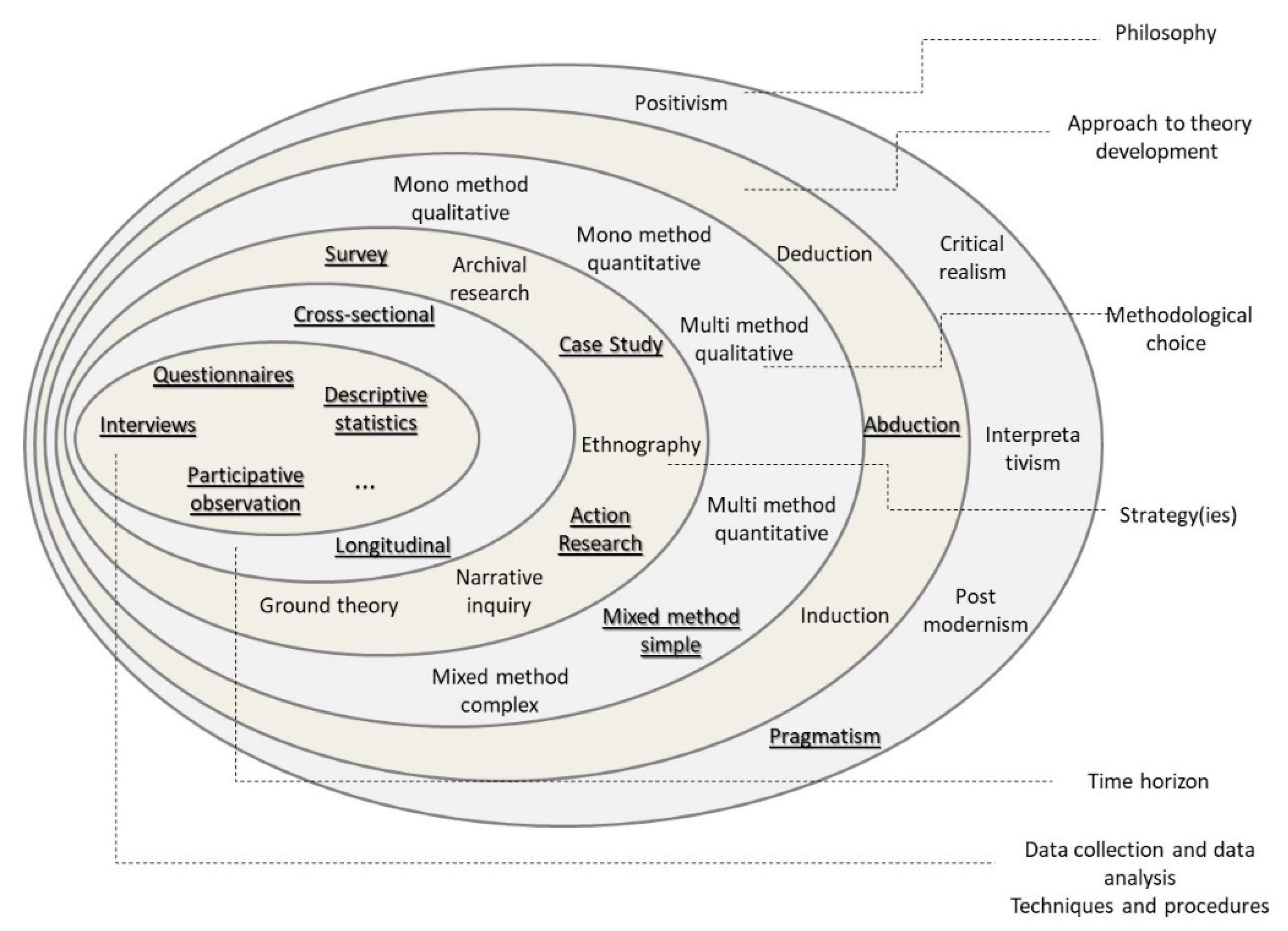
  44. Saunders, M.; Lewis, P.; Thornhill, A. Research Methods for Business Students, 8th ed.; Pearson Education Limited: New York, NY, USA, 2019. [Google Scholar]
  45. Bryman, A. Social Research Methods, 4th ed.; Oxford University Press: Oxford, UK, 2012. [Google Scholar]
  46. dos Santos, L.A.B.; do Vale Lima, J.M.M.; Garcia, F.M.G.P.P.; Monteiro, F.T.; da Silva, N.M.P.; dos Santos, R.J.R.P.; Afonso, C.F.N.L.D.; da Piedade, J.C.L.; Laranjo, P.J.F.; de Almeida Fachada, C.P. Orientações Metodológicas para a Elaboração de Trabalhos de Investigação. Cadernos do IUM N.8. 2019. Available online: https://www.ium.pt/s/wp-content/uploads/20190821_CAD-08_Miolo_WEB-1.pdf (accessed on 12 January 2021).
  47. Deming, W.E. Out of the Crisis; MIT Press: Cambridge, MA, USA, 1986. [Google Scholar]
  48. Sokovic, M.; Pavletic, D.; Pipan, K.K. Quality Improvement Methodologies—PDCA Cycle, RADAR Matrix, DMAIC and DFSS Industrial management and organisation Industrial management and organisation. J. Achiev. Mater. Manuf. Eng. 2010, 43, 476–483. [Google Scholar]
  49. Corcoran, P.B.; Walker, K.E.; Wals, A.E.J. Case studies, make-your-case studies, and case stories: A critique of case-study methodology in sustainability in higher education. Environ. Educ. Res. 2004, 10, 7–21. [Google Scholar] [CrossRef]
  50. Yin, R.K. Estudo de Caso: Planejamento e Métodos, 2nd ed.; Bookman: Porto Alegre, Brazil, 2001. [Google Scholar]
  51. Neuman, W.L. Social Research Methods: Qualitative and Quantitative Approaches; Pearson New International Edition: Essex, UK, 2014. [Google Scholar]
  52. UN-GGIM. Framework for Effective Land Administration: A Reference for Developing, Reforming, Renewing, Strengthening, Modernizing, and Monitoring Land Administration; UN-GGIM: New York, NY, USA, 2020. [Google Scholar]
  53. Spradley, J.P. Participante Observation; Waveland Press: Long Grove, IL, USA, 2016. [Google Scholar]
  54. Deininger, K.; Selod, H.; Burns, A. Areas Covered by the Land Governance Assessment Framework; The World Bank: Washington DC, USA, 2012. [Google Scholar]
  55. Balas, M.; Carrilho, J.; Murta, J.; Matlava, L.; Marques, M.R.; Joaquim, S.P.; Lemmen, C. A Fit-For-Purpose Land Cadastre in Mozambique. In Proceedings of the 2017 World Bank Conference on Land and Poverty—Responsible Land Governance: Towards an Evidence Based Approach, Washington, DC, USA, 20–24 March 2017. [Google Scholar]
  56. Groenendijk, E.M.C.; Lemmen, C.; Bennett, R.M. Educational tools for fit for purpose land administration: Experiences and lessons from Mozambique. GIM Int. 2016, 30, 29–31. [Google Scholar]
  57. Norfolk, S. Aplicação da Cadeia de Valor da Terra Comunitária (CaVaTeCo) nos Processos de formalização da posse da terra e a Emissão de Certificados de DUATs pelas Comunidades Locais; Terra Firma: Maputo, Mozambique, 2017. [Google Scholar]
  58. RICS. Crowdsourcing Support of Land Administration: A New, Collaborative Partnership between Citizens and Land Professionals. RICS Research Report (November). 2011. Available online: https://www.clge.eu/wp-content/uploads/2012/05/16310_RICS_Crowdsourcing_Report-final-WEB.pdf (accessed on 15 January 2021).
  59. Dalupan, M.; Haywood, C.; Wardell, D.A.; Cordonnier-Segger, M.C.; Kibugi, R. Building Enabling Legal Frameworks for Sustainable Land-Use Investments in Zambia, Tanzania and Mozambique: A Synthesis; IDLO: Nairobi, Kenya; CIFOR: Nairobi, Kenya, 2015. [Google Scholar]
  60. McLaren, R. Crowdsourcing support of land administration—A partnership approach. Int. Fed. Surv. Artic. Mon. 2011. Available online: https://www.fig.net/resources/monthly_articles/2011/mclaren_december_2011.asp (accessed on 31 October 2020).
  61. Deininger, K.; Augustinus, C.; Enemark, S.; Munro-faure, P. Innovations in Land Rights Recognition, Administration, and Governance; A World Bank Study: Washington, DC, USA, 2010. [Google Scholar]
  62. Jones, B.; Lemmen, C.; Molendijk, M. Low Cost, Post Conflict Cadastre with Modern Technology. In Proceedings of the Responsible Land Governance: Towards and Evidence Based Approach, Washington, DC, USA, 20–24 March 2017; The World Bank: Washington, DC, USA, 2017. [Google Scholar]
  63. Reydon, B.; Molendijk, M.; Lemmens, C. Land Titling Costs: Evidence from Literature and Cases Using FFP. 2020. Available online: https://research.utwente.nl/en/publications/land-titling-costs-evidence-from-literature-and-cases-using-ffp (accessed on 21 February 2021).
  64. Antonio, D.; Njogu, S.; Nyamweru, H.; Gitau, J. Transforming Land Administration Practices through the Application of Fit-For-Purpose Technologies: Country Case Studies in Africa. Land 2021, 10, 538. [Google Scholar] [CrossRef]
  65. Enemark, S.; Mclaren, R.; Lemmen, C.; Antonio, D.; Gitau, J. Scaling Up Responsible Governance: Guiding Principles for Building Fit-For-Purpose Land Administration Systems in Developing Countries. In Proceedings of the 2016 World Bank Conference on Land and Poverty, The World Bank, Washington, DC, USA, 14–18 March 2016. [Google Scholar]
  66. Balas, M.; Carrilho, J.; Murta, J.; Joaquim, S.P.; Lemmen, C.; Matlava, L.; Marques, M.R. Mozambique Participatory Fit For Purpose Massive Land Registration. In Proceedings of the 2017 World Bank Conference on Land and Poverty—Responsible Land Governance: Towards an Evidence Based Approach, The World Bank, Washington, DC, USA, 20–24 March 2017. [Google Scholar]
  67. Laarakker, P.; Zevenbergen, J.; Georgiadou, Y. Land Administration Crowds, Clouds, and the State. In Advances in Responsible Land Administration, 1st ed.; CRC Press: Boca Raton, FL, USA, 2015; pp. 91–114. [Google Scholar]
  68. Carrilho, J.; Balas, M.; Marques, M.R.; Macate, Z. Addressing Fuzzy Boundaries in Community Delimitations for Systematic Cadastre in Mozambique. In Proceedings of the 2019 World Bank Conference on Land and Poverty—Catalyzing Innovation, Washington, DC, USA, 25–29 March 2019. [Google Scholar]
  69. Balas, M.; Joaquim, S.; Almeirim, J. SiGIT Land Information System and the Challenges Imposed by the Fit for Purpose Approach to Land Administration. In FIG Congress 2018 Embracing Our Smart World Where the Continents Connect: Enhancing the Geospatial Maturity of Societies; FIG: Istambul, Turkey, 11 May 2018. [Google Scholar]
  70. ISO. ISO 19152:2012 Geographic Information—Land Administration Domain Model, 1st ed.; ISO: Geneva, Switerzeland, 2012. [Google Scholar]
  71. Hartlief, V.; Ntauazi, C.; Deus, N.R.; Santpoort, R.; Steel, G. Documento de Trabalho 2: Assegurar os Direitos da Mulher à Terra no Continente Africano—Moçambique; LANDac: Utrecht, The Netherlands, 2018. [Google Scholar]
  72. Balas, M.; Carrilho, J.; Joaquim, S.P.; Murta, J.; de Carvalho, J.A.; Lemmen, C. Assisted Community-Led Systematic Land Tenure Regularization. In Proceedings of the 2018 World Bank Conference on Land and Poverty—Land Governance in an Interconnected World, Washington, DC, USA, 19–23 March 2018. [Google Scholar]
  73. Balas, M.; Carrilho, J.; Vaz, K. The Role of Communities in Land Cadastre Maintenance. In FIG Working Week 2019 Geospatial Information for a Smarter Life and Environmental Resilience; FIG: Hanoi, Vietnam, 26 April 2019. [Google Scholar]
  74. Lewis, L.K. Vital Considerations for Software Implementation: How to Ensure Success of Your New Land Administration System; Reuters, T., Ed.; Thomson Reuters Aumentum: Toronto, ON, Canada, 2009; Available online: https://tax.thomsonreuters.com/site/wp-content/pdf/aumentum/10-Considerations-3S-Whitepaper.pdf (accessed on 14 February 2016).
  75. Land Equity International. Land Administration Information and Transaction Systems: State of Practice and Decision Tools for Future Investment; Report No. 95332419c00892020; Land Equity International: Wollongong, Australia, 2020. [Google Scholar]
Figure 1. The “research onion” as a reference framework for the design of this research. Source: Adapted from ©2018 Mark Saunders, Philip Lewis and Adrian Thornhill [44].
Land 10 00818 g001
Figure 2. The Conceptual Model for developing the FFPLA-MOZ approach based on three intertwined pillars: People, Processes and Technology.
Land 10 00818 g002
Figure 3. Meeting the local community council—Chizavane cluster.
Land 10 00818 g003
Figure 4. Meeting with women separately to ensure they understand their rights.
Land 10 00818 g004
Figure 5. Teaching a “Queen” (female community leader) to read the map.
Land 10 00818 g005
Figure 6. Example of the adjustments made to the community boundaries based on the individual parcels’ registrations.
Land 10 00818 g006
Figure 7. Using the mobile application to collect alphanumeric and geographic information.
Land 10 00818 g007
Figure 8. All parcels were validated by the local authority.
Land 10 00818 g008
Figure 9. The processes of the FFPLA-MOZ approach. Outer ring: Managerial processes (Plan, Monitor and Control, and Evaluate and Close). Inner ring: Execution processes (Prepare the Field Work, Prepare Communities; Collect Data in the Field, Process Data, Deliver Documents and Close Project). Source: Developed from [37].
Land 10 00818 g009
Figure 10. Example of part of the orchestration of processes. A visualization of the workflow for each process or subprocess. Source: [37].
Land 10 00818 g010
Figure 11. SiGIT Land Information System Business Processes. Source: [37].
Land 10 00818 g011
Figure 12. A group of women getting their land titles from the president of Mozambique.
Land 10 00818 g012
Publisher’s Note: MDPI stays neutral with regard to jurisdictional claims in published maps and institutional affiliations.

