Article

De-/Fencing Grasslands: Ongoing Boundary Making and Unmaking in Postcolonial Kenya

by
Mette Løvschal
1,2,*,† and
Marie Ladekjær Gravesen
3,†
1
Department of Archaeology and Heritage Studies, Aarhus University, Moesgaard Allé 20, 8270 Højbjerg, Denmark
2
Moesgaard Museum, Moesgaard Allé 20, 8270 Højbjerg, Denmark
3
Danish Institute for International Studies, Østbanegade 117, 2100 København, Denmark
*
Author to whom correspondence should be addressed.
The authors have contributed equally to this work.
Land 2021, 10(8), 786; https://doi.org/10.3390/land10080786
Submission received: 9 April 2021 / Revised: 5 July 2021 / Accepted: 12 July 2021 / Published: 27 July 2021

Abstract

:
Across contemporary East Africa, fencing is spreading with incredible speed over hundreds of thousands of hectares of rangelands, fundamentally reconfiguring land tenure dynamics. But why is this happening now, what are the precursors, and what will happen in the years to come? In this article, we ask how pre- and post-colonial landscape gridding perpetuate a slow violence across the landscape through processes of de-/fencing. Fencing, we argue, is embedded in a landscape logic that favours exclusive rights and conditioned access. In two case studies from grazing lands in Kenya, we explore how people engage with the tension of an imposed landscape logic of fencing by either asserting or challenging its very physicality. We propose that de-/fencing are ways of anticipating long-standing land tenure uncertainties. Moreover, we use our cases to explore different points of reference along the mattering of land tenure boundaries as well as the sort of horizons to which fencing leads. We also use this knowledge to improve our understanding of parallel prehistoric cases of large-scale landscape enclosure. By unfolding the intertwined socio-political and material nature of gridded landscapes, we seek to bring the study of fencing out of conservation literature and into its wider culture-historical context.

1. Introduction

There have never been as many fences across the globe as there are today. The wide-scale enclosure of rangelands, croplands, conservation land, parks and urban areas is becoming increasingly common [1]. These fences are not only raised to protect soils, crops, plants, people and animals, but also often represent deeply complex underlying histories of enclosure, as well as symbolic and communicative executions of power. This is the case whether one looks at the (pre-)historical land enclosures of the Americas, Australia and Northern Europe (Section 4.1), or the major state projects of making walls in the West Bank, Jericho or at the Mexican border. As a consequence, forces of resistance against the political or economic powers that fences and walls embody are often accompanied by attempts to physically trespass, resist or unmake the very physicality of these material gestures.
The processes by which boundaries are turned into physical fences, their ‘mattering’ [2], is by no means less pertinent in present-day East Africa [3,4]. Here various types of fences have spread in various contexts, including veterinary fences, land privatization enclosures, group ranches, or national borders. Lately, fences have also increasingly been raised around areas designated as national parks or conservation areas. Consequently, the majority of studies of fencing in East Africa derive from conservation and ecological agendas and short-term studies. However, the fences are often embedded in long-term histories in which power differentiation has been reinforced through other forms of enclosure, which also fundamentally violates other forms of being in, moving in and negotiating access to space. Hence, not only does the sheer pace and magnitude of fencing make the phenomenon interesting, but it also invites inquiry into how pre- and post-colonial dynamics continue to perpetuate a ‘slow violence’ [5] across the landscape. A slow violence that is expressed through material processes of de-/fencing as well as through state legislation, conservation efforts, and even through research enquiries and intellectual property rights [6].

1.1. Aims and Scope

In this paper, we wish to bring the study of fencing into its wider historical context by inquiring into the processes of turning boundaries into linear, physical fences and walls. Moreover, we wish to establish a theoretical framework for understanding fences where essentially philosophical notions are used to elucidate what it means to erect fences and barriers, as a ‘mattering’ of boundaries. Using two case studies from Kenya’s Rift Valley region, the Laikipia plateau and the Greater Mara, we explicitly investigate the historical and material creation of boundaries: what happens when boundary demarcation is turned into physical fences. –Each with its own historical trajectory of boundary mattering taking place in different tempi from incremental (Laikipia) to event-like (Mara).
In both these areas, boundaries have appeared throughout history in various forms. However, we focus on the particular relationship between colonial boundary-making and material practices of fencing grasslands. Our aim is to explore how pastoralists are currently reinforcing the very rhetoric of violence, inequality and marginalization of a particular part of the past that they seek to escape. We base our research on our own ethnographic fieldwork (2014–2017) and interviews, combined with archival resources and key secondary sources (see Materials and Methods Section); and for the Mara case, also a geospatial mapping of the fencing expansions. In the Laikipia case, fencing slowly started to spread from the 1950s when colonial settlers sought to protect their ranches against encroachment by wild animals and pastoralists. In this case, we show how a renewed phase of deep-seated historical protest actions and radical de-fencing efforts by pastoralists are directed against the fences. The Greater Mara, on the other hand, has remained largely unenclosed until a decade ago. Currently, however, fences are spreading on an unpredictable scale, a process that is partly driven by Mara pastoralists themselves, in part as a way of anticipating the repercussions of colonial and post-colonial marginalisation.
The cases reflect two fundamental strategies of resisting enclosure and its associated forms of violence: one by physically opposing its very materiality, the other by using it to create a space for emancipation. We use ‘de-/fencing’ to refer both to the act of asserting resistance to the exclusion that a fence represents by either dismantling it or blocking access to it, and ‘defending’ one’s land by erecting a fence along a boundary. The latter case illustrates the paradox of marginalization leading herders to fence, which undermines pastoralists’ access to grazing. Moreover, we define binding as adding a boundary to and circumscribing something which is otherwise unbound and uncontained. Here we show how pastoralists use material practices of binding and fencing land as a form of postcolonial unbinding; and fencing as a defence against increasing yet unpredictable pressures from tourist industries, state interests, farming initiatives, conservation and nature protection initiatives and imminent economic investments. In the former, we claim that pastoralists regard fencing as an instrument of exclusion and dominance wielded by white farmers. In Laikipia, pastoralists achieve political empowerment through practices of unbinding and de-fencing land in very concrete physical terms.
Hence, the article explores the deeper im/material dimensions of boundaries beyond those of conservation issues; the ways in which humans and landscapes get caught up in particular long-term trajectories and cascading effects of ongoing social, ecological or political violence; and overall, how difficult (yet not impossible) it is to get rid of boundaries again once they are inscribed in the landscape as symbolic gestures. By exploring how material practices of boundary making and unmaking unfold across several generations—as a means of tackling landscape futures that are made uncertain by constrained pasts—we seek to add a new long-term dimension to the spread of fencing that is currently unfolding in East Africa. Moreover, we will use our study to present new perspectives on the study of prehistoric landscape gridding, such as that which took place in Bronze Age Northern Europe, including a greater sensitivity towards pastoralists and the potential ongoing ramifications of their long-term existence.

1.2. Research Background: Boundary Disputes in the Aftermath of Colonialism

Social and political science studies have provided rich insights into the insecurities and inequalities of land relations among marginalized population groups, including pastoralists, across (pre- and post-)colonial sub-Saharan Africa. These studies include explorations of territorialisation, tenure, privatization, land-use fragmentation and manifestations of land claims [7,8,9,10,11,12,13,14,15,16,17,18,19,20,21,22,23].
However, the initial colonial practices which laid the foundations of unequal land tenure—dividing the land into grids, thereby creating the discourse within which people are forced to navigate—remain somewhat neglected in this literature. Relevantly, the fences are often seen as reflections of claims yet not in themselves drivers of resistance. Nevertheless, the aspects of claim-making offer valuable insight into a contextual frame of reference for de-/fencing practices [24,25,26,27,28]. For example, some studies have paid attention to the ambiguities of state authority in land matters following Independence and how this has influenced people’s abilities to navigate land tenure and effectuate land claims [29,30,31,32,33,34,35]. A situation that is illustrated by both our case studies. Other scholars approach tenure as a process of (re-)negotiation, arguing that the agency of those who seek access is as critical for scholarly inquiries as questions of what the state does or does not do [32,36,37,38]. Other inquiries into gridding processes have shown how the introduction of land privatization can make some people tenureless—making them unlawful trespassers when crossing newly drawn boundaries onto land they previously used and continue to depend on [29,39,40,41]. Such processes of enclosure can lead to resistance and protest, as our case studies also show. Several studies document how, if left unaddressed, such land grievance protests can trigger enduring disputes with resurging conflicts [30,42,43]. Some Africanist scholars have focused specifically on agency and resistance among pastoral and farming communities, including strategies of resistance and successful challenge of land tenure injustices (see for instance [44,45,46,47]). Although exploring the sphere of agency in land relations, none of these studies specifically delve into the material strategies and agency of de-/fencing.
Studies with an explicit focus on the materiality of enclosure have, however, largely appeared in separate debates on ecosystem conservation, nature preservation agendas and biodiversity [2,48,49,50,51,52,53,54,55]. Here, the perpetuating effects of enclosure are investigated in relation to wildlife migrations, biodiversity issues, the separation of livestock and wildlife and the prevention of human-wildlife conflicts. Seen in this light, fencing is an irrational and short-sighted material practice which should preferably be avoided.
Hence, the very materiality and long-term repercussions of these deeply entangled processes of structurally marginalizing land tenure reconfigurations have been largely overlooked. Seeing fences as either functional means or political symbols ultimately reinforces a split between environmental and humanistic approaches. The following section therefore provides a series of anthropological, philosophical and new materialist perspectives that are potentially able to bridge such approaches and can be used as a steppingstone for our two empirical cases.

1.3. The Material Resonance of Boundaries

Boundary-making practices are material-discursive ways to articulate and (re)configure the world. The gridded, enclosed and striated spaces based on exclusion are radically different from smooth and nomadic spaces [56]. Striated spaces refer here to the enclosed or closed-off surfaces that can be quantified, contrasted, allocated and e.g., turned into ‘grass banks’ (see l. 556 ff.). The binding instantiates a physical violation and a semiotic cut between inside and outside, between object and subject [57] (p. 140). The enclosure of areas violates existing ways of living, moving and organizing in the landscape deliberately, processually and structurally [58] (p. 733). This violation is also what Svend Erik Larsen notices when he writes that: “Boundaries are only interesting when they separate things that cannot really be separated, doing this in such a way that we are forced to view the separated parts together” [59] (p. 105, authors’ translation). This enacts distinction and instantiates difference [60] and differentiation, whether it encloses landscapes, people, or both. This difference violates the present situation and asserts a force or pressure on its surrounding space.
However, boundaries project not only particular categorical distinctions but also power relations and hierarchies. The ‘cut’ of the boundary mobilizes a dialectical making of this side and the other side; of a ‘me’ and ‘you’, ‘us’ and ‘them’ or ‘this’ and ‘the other’ [61,62,63]. The material enaction of enclosing and othering are closely related productions of human nonhuman life hierarchies and power structures. Such hierarchies include “principles for recognizing or dismissing claims” to land [32] (pp. 1203–1204). Hence, the boundary expands privilege and autonomy for those erecting it and limits the room for manoeuvre of others. It delineates a form of collective orientation in time and space, a shared horizon for potentiality, although it may not be agreed upon by those outside it. This makes boundaries forceful technologies of empowerment and marginalization that can be taken advantage of, politicized, and used to anticipate future scenarios.
Not only are the social and cultural dimensions of the ‘cut’ of the boundary interesting; so are its mattering, understood as the processes by which boundaries are turned into physical fences. A series of scholars have addressed the perceptual dimensions of material lines and linear boundaries, including Tim Ingold’s unfolding of the morphological qualities of linear structures, Eviatar Zerubavel’s studies of everyday categorizations and mutually constituting notions of boundaries, and Barry Smith’s notion of fiat and bona fide boundaries [62,64,65,66,67,68,69]. With a much more explicit contextualization in the study of claims, Kronenburg and van Dijk explore three types of claims with each their way of marking and demarcating new boundaries, as well as challenging existing ones. These include grounding claims e.g., de/fencing; talking claims e.g., story-telling; and representing claims e.g., maps and title deeds [70] (pp. 6–7). All these studies show a complex nonlinear relationship between invisible and material boundaries, between punctuated and linear, seasonal and permanent boundaries. However, the long-term consequences of the physical boundary mattering remain far less explored. In a study of the 16th–17th century English countryside, Blomley explores the role of hedges in the ‘remaking and reconfiguration of property’ from common land to privatization [71]. He shows how hedges affect how bodies move and behave, as well as their ability to see. Across a longer time span, the physical presence of hedges not only increase the request for more fences but also taller and more impenetrable hedges (p. 12). Moreover, protests against the land privatization manifest as physical violations of hedges.
Fences afford a different establishment of rights. The mattering of boundaries, although in principle instantiating a centrifugal force or a cut, tends to simultaneously enforce a central point of attention. Before fences are inscribed in a landscape, protest and resistance can take a series of different forms, and the ambiguity, permeability and potential overlap of other forms of boundaries can even be conflict-reducing. However, once fences are mattered, they instantiate a spatial discourse that is difficult, if not impossible, to ignore. To our knowledge, we do not yet have a concept for this – the fence as a game changer, a synecdoche and material articulation, a simplified but unavoidable physical means that makes social and political tensions hinge upon it and escalate around it. More than simply reflecting an existing tension or difference, fences actively conjure tension and difference and reinforce hierarchical power dynamics. To supplement Larsen’s proposal that the boundary is nothing in itself, the very physical presence of the fence can change the character of a conflict and turn itself into the focus of it. This may make the conflict somewhat more manageable and tangible, but their visual and material emphasis also creates inertia and inflexibility in the process of resolving conflict [58,72,73].
Inquiring more specifically into the historical and political contexts of fences and the long-term effects of enclosure, Stoler’s notion of ‘imperial debris’ is particularly useful [74]. She argues that it is impossible to reverse a violent and oppressive history simply through decolonization. Instead, historical (im)material and unresolved issues of political marginalization can sustain and force a connection to a political past. Hence, the notion of imperial debris points to the endurance of structures of power—to the nonlinear and unsynchronized ways in which people disentangle themselves from the past. This is the case, for instance, with regard to the colonial carving out of a social hierarchy with established categories of ‘ruler’, ‘subject’ and ‘excluded’, which continues to manifest itself in various ways [75]. It is also the case for the material imprints of landscape boundaries. These may not simply constitute dead matter or frozen glimpses of the past, but in similar ways continue to be “stubbornly inhabited to make a political point, or requisitioned for a newly refurbished commodity life for tourist consumption” [74] (p. 197). Fences, like other material colonial remains, can thus develop into “epicenters of renewed claims, as history in a spirited voice, as sites that animate new possibilities, bids for entitlement, and unexpected political projects” [74] (p. 198). Such historical sediments contain a charged potential that can be activated to substantiate new claims, narratives or hierarchies [76]. Thus, the conjuring power of a fence depends on whether past conflicts or unequal power relations have been resolved or merely petrified.
In other words, erecting a fence never leaves a place quite the same: it carries with it a cut, a pressure on time and space of violence, a difference. Its violence is often ‘slow’ in the sense of being gradual and anticipated or accompanied by other forms of violence, such as corporeal violence, yet often not in itself viewed as violent [5]. This has long-term consequences for the ways in which boundaries tend to resonate once they are ‘mattered’ [58,73]. Once they have obtained regularized morphologies and been embedded in particular cultural practices and notions (e.g., of prosperity, security, expansion, accountability), fences tend to instantiate interlocking trajectories that are difficult to escape from again, as our case studies show.

2. Materials and Methods

We build our study on 12 months of ethnographic fieldwork undertaken in 2014–2017, including observations and 80 semi-structured interviews with pastoralists, smallholder farmers, ranch and conservancy managers, farm workers, security personnel, landowners and county-level politicians. All the interviews were undertaken with due regard for the diverse ethnicity, gender and wealth-related aspects of the social landscape in and around Laikipia and Mara. For ethical reasons, the identities of the interviewees are withheld and only initials are used. The prime ethnographic data on the processes and implications of fencing was collected as part of a PhD project on the broader ramifications of Laikipia’s land claims and contestations, which, however, did not go extensively into fencing [43].
Given the long-term perspective of this study, archival resources were included to supplement the oral accounts. With regard to the Greater Mara case in particular, we consulted a range of Foreign and Commonwealth Office files from the 1950s and 1960s at the National Archives in Kew, as well as secondary sources of the long-term dynamics of the social, environmental and political landscape (especially [11,77,78,79,80]). We also consulted new geospatial mappings of fences based on satellite images from (1965)1985 to 2020, and their associated ground truthing studies [81,82,83]. This was done to show the magnitude and pace with which fences are spreading across the Greater Mara.
As such, there is a complementary overrepresentation of qualitative data on Laikipia and quantitative fencing data and secondary sources on the Mara. The combination of different data sources facilitates a deeper inquiry into how landscape striation, -binding, -enclosure and -gridding has been mattered and transformed into fixed material fences.

Empirical Background

The Laikipia plateau is located some 250 kilometres north of Nairobi and spans 869,600 hectares from the semi-arid northern rangelands to the more fertile farmland and woodlands of the south-west. The Greater Mara is located some 200 kilometres southwest of Nairobi, in the northernmost section of the Serengeti-Mara ecosystem, and covers an area of 668,500 hectares in a semi-arid climate.
Archaeological evidence and oral history indicate that hunter-gatherer groups and pastoralists were present in Laikipia since 3000 BP. However, around c. 1750 AD, the pastoralism European explorers and colonialists encountered started to be fleshed out as well as sectional identities. Around that time, shifting groups of pastoralists and hunter-gatherers settled in the region, managing the use of grazing and water sources on the plateau and surrounding lowlands through transhumance and herding [20,84]. Similarly, in the Greater Mara region, pastoralist groups have been present for at least the past three centuries [85]. In the early 19th century until the 1870s, different Maasai sections expanded their territories to cover vast areas of Kenya in what became known as Maasai land [80] (p. 84). This included the Laikipia plateau, where the Laikipiak Maasai defended water and grazing resources against their use by other pastoral and hunter-gatherer groups [86]. Although largely unfenced, land in Mara and Laikipia was still marked by boundaries of various sorts. These were relatively mobile, often shifting and penetrable, and sometimes marked, not by fences, but branches, stones and naturally occurring features in the landscape such as rivers, hills or exceptionally large trees [80,85,87,88]. Access was negotiated through physical force and presence, and the use of land and water was regulated customarily by community members and elders. In the late 19th century, following a rinderpest outbreak and a series of wars between Maasai, known as Iloikop, the Laikipiak Maasai were severely fragmented and dispersed as refugees among other neighbouring groups, leaving Laikipia accessible for other groups [77].
In the Greater Mara as well as in Laikipia, land remained largely unfenced throughout this period [86].
During the colonial era ((1895)1920–1963), both areas became lawfully mapped to determine which groups had the right to access and hold them—demarcations that followed Western enlightenment principles of enclosure and exclusion. Following James Scott, these practices of boundary-making can be seen as part of a state-making process [89]. Categories included common land in Native Reserves, and private property for European settlers in the Crown Lands [27]. Hence, a new landscape emerged which was parcelled out following principles of a formal yet ’invisible grid (cf. Kronenburg and van Dijk’s representing claims). The new lines, initially existing almost exclusively on maps, followed a different logic and spatial discipline than that prior to 1895. Colonially established land boundaries now also formally excluded people who had previously had access, causing pastoralists to rebel and push for a continued access to grazing across the boundaries [90].
Following Independence (1963), the tenure system saw further changes despite the avoidance of a comprehensive land reform. The political rhetoric in the 1960s encouraged land acquisition and (in)formal settlements on Laikipia’s former Crown Lands as well as on the fringes of the Mara by mixed ethnicity groups. Although Kenyan citizens were formally equipped with equal rights to acquire land as private property, in practice some ethnic groups were favoured in land allocations while others saw their customary land privatized by others [91,92].
This is where our empirical studies unfold: at a time when authority had been handed over to the independent Kenyan state and the pressure from colonial land claims had been formally released. However, the principles of cartographic delineation and associated logics of exclusive property continued to be deeply embedded in these landscapes as fences and various practices of enclosure (Figure 1).

3. Results

3.1. The Laikipia Plateau

We begin our enquiry after pastoral grazing territories were designated as land held by the British Crown in 1895. This cleared the way for colonial settlement on ranches that spread in the 1920–1930s [93]. The Crown Lands were both authorised on cartographic maps by the Department of Lands and Settlement, and regulated as actual physical enclosures, initially via patrols, guards and police presence. For the European farmers, the protection of crops and livestock was essential, and to that end, simple wire fences proved increasingly beneficial around ranches, particularly towards the end of the colonial era. Following Independence (1963) and up through the 1990s, many colonial farms transitioned into smallholder or subsistence farms. Today, Laikipia is an ethnically and socially diverse area which continues to be home to some colonial settler families, large-scale livestock ranching, and wildlife conservancies, alongside pastoralism, and smallholder farming. The area has been marked by escalating political, racial and ethnic-based conflict particularly since the 1990s with repeated episodes of orchestrated invasions of ranches and conservancies, most recently in 2016–2017 [43]. The fences in Laikipia adopt multiple morphologies and serve a range of purposes, and include electrified elephant fences, stone walls and simple wire fences around smallholder fields or pastures for ranch cattle.

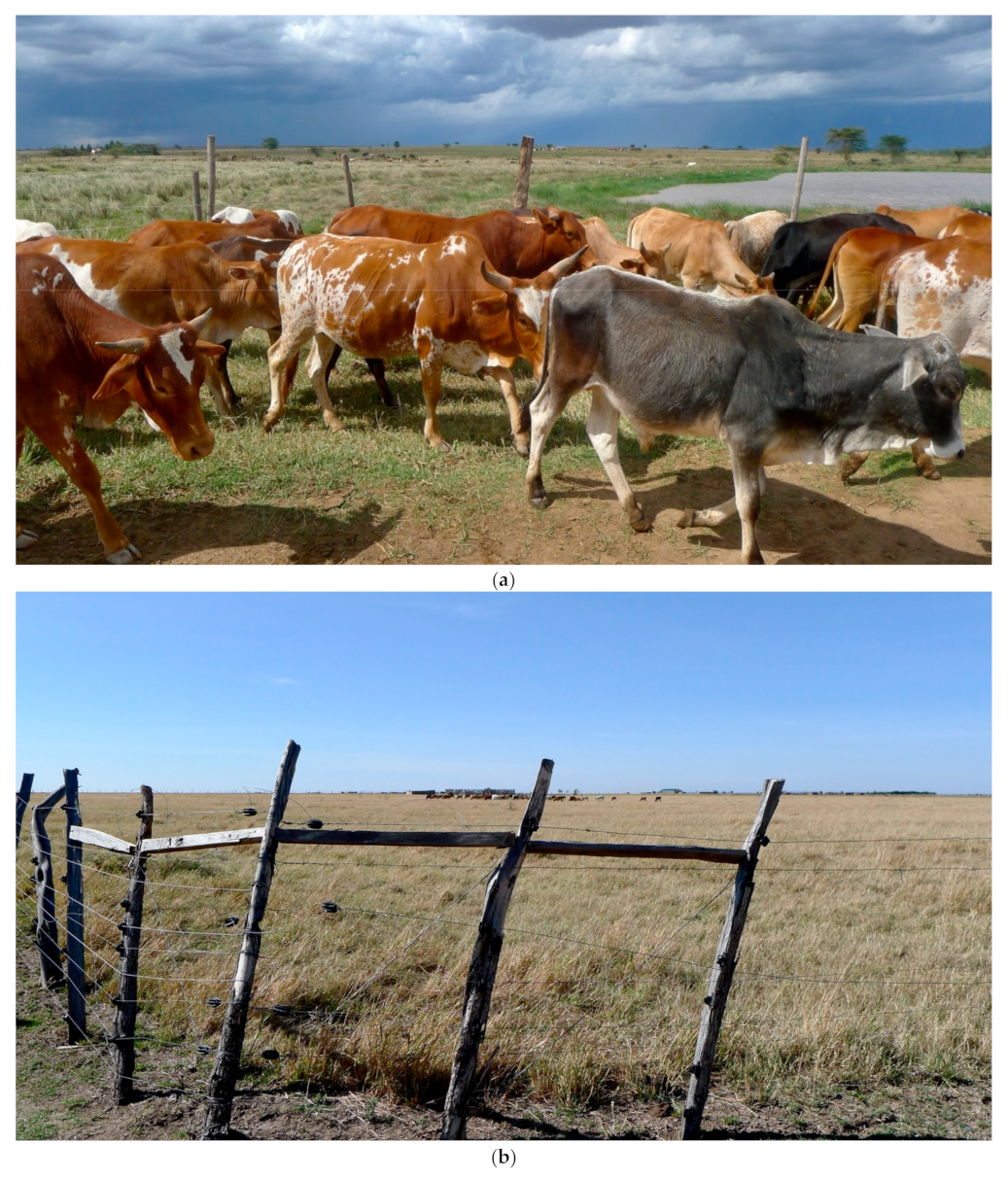
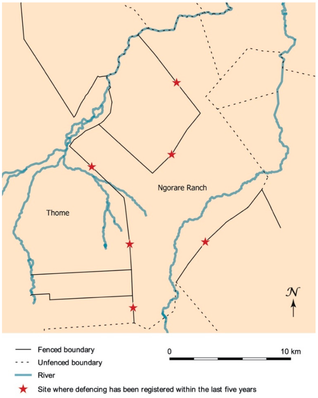
The Fence between Thome and Ngorare Ranch

The Thome-Ngorare boundary in present-day central Laikipia is indicative of a general juncture of practices of de-/fencing that take place on a wider scale across Laikipia. Two former colonial ranches, Thome and Ngorare, are located next to each other, their boundary marked by a fence. Thome comprises 17,000 acres, against Ngorare’s 38,000 acres. The fence is continuously enforced by one side and deconstructed by the other. During the colonial era, both ranches were run by white leaseholders under a 100-year lease, and both were situated in what was referred to as ‘the white highlands’ [11]1. Today, both continue to be registered as private property by the Kenyan state.
Until 1976, Thome was run by Carr Hartley, partly as a cattle ranch and partly as a business capturing wild animals to sell to European zoos. Some of his former labourers still live in the area. They and current ranch managers describe how, during colonial times and up until 1976, few of Laikipia’s ranches had electrified or fully fenced boundaries [94,95,96,97,98]. This is not to say that the white settlers in the Crown Lands did not experience encroachment by herders with their livestock, and wildlife, and could have benefitted from a fence. In fact, such encroachment was widespread and referred to as “a menace to white settlement” [99]. However, because of financial scarcity, infrastructural deficits and the presence of wildlife, it was costly to establish and maintain fences. Instead, ranch managers patrolled the boundaries on horseback, chasing out trespassers using firearms [97].
Gradually though, the ranches started to become fenced to deter pastoralists from accessing grazing across their boundaries, which had so far only existed on paper. At Thome however, fences were not employed, as Hartley’s former workers explained. Because of his focus on wildlife capturing, Hartley only used fences for paddocks that contained wildlife to be exported, while his cattle were managed by herders [94,100].
In 1976, Hartley sold Thome to a land-buying company founded by the aspiring Kenyan politician Arthur Magugu, and the area started to become settled by smallholders. However, the overselling of land share certificates made them untransferable to title deeds, leaving large tracts of the former ranch area seemingly vacant and unfenced [101,102]2.
In the early 1990s, pastoralists from the north started to occupy the seemingly vacant areas in Thome. According to Kenyan law, they had no legal tenure, but were considered squatters. However, the availability of grazing grounds on the smallholder lands attracted so many pastoralists that the area quickly faced substantial grazing pressure. “When we started to come here, we weren’t many and didn’t steal grass. But when we grew in number, we started to steal grass,” one pastoralist explained [103]. Interestingly, the statement indirectly recognizes the claim of ranchers and smallholders by indicating that the pastoralists were ‘stealing’ from them. As more people settled here, the grass in Thome became scarce and the pastoralists started to let their herds graze across the boundary to Ngorare.
The colonial settler on Ngorare ranch, Wai Wai, was still living on the ranch in the 1990s and had very little fencing around his 38,000 acres up until his death in 2004. Like Hartley, he had his cattle tended by herders and he would patrol the ranch borders. One pastoralist explained that Wai Wai “...used to patrol and carry the gun openly. He used to shoot in the air to scare trespassers. When Wai Wai caught anyone trespassing and using illegal routes, it was worse. He would tell you to climb the Land Rover at the back and stand in the centre where you could not support yourself, then he would drive at the top speed and make an emergency break, so you would hit the bars” [103].
The new manager confirmed that a ... fence was basically non-existent” under Wai Wai’s management [104]. When he took over the ranch, though, he started to gradually establish and electrify fences along most of Ngorare’s boundaries, one section at a time [104]. A decade later, in 2015, there were 30 kilometres of electrified wire fencing bordering Thome and other pastoralist settlements (Figure 2). Towards Ngorare’s northern boundary, the new manager did not erect fences, as the neighbouring ranches, Segera and Sosian, were under similar large-scale management, he explained [104]. However, the fences did not solve the problems of trespassing and grazing along the southern fringes of the ranch boundary. As its morphological elaboration increased, so did the pastoralists’ efforts to access its interior. Repeatedly, the fence was cut and grazing at night increased. “The Samburu can cut the wires,” a smallholder in Thome explained, “you see, they stretch the wires upwards to make ways for their animals at the bottom. The fence is electric but has soft wires” [100].
The escalation of the conflict pertaining to boundary violations caused a great feeling of uncertainty among the surrounding residents. “It is dangerous at night – the Samburu can attack you”, a Thome smallholder warned [100]. After some time, the Samburu started to cut trees and collect stones to block the roads on the ranch, as de-facto fences, so that the manager’s patrols would be hindered. “They think that when they do that, they have ownership”, the new manager explained [104]. Elsewhere in Laikipia, ranch boundaries have recently been equipped with barbed wire, trenches, electronic alarm systems and stone walls so that grazing inside the boundaries is indeed effectively unreachable and the boundaries are in-de-fencible. However, there are also recent examples of persistent de-fencing that, in combination with other forms of conflicts, political pressure and threats, have pushed ranchers to abandon or sell and leave the land.
Many Laikipia pastoralists regard fencing as an instrument of dominance, associating it with logics of land governance that exclude mobile livelihoods which, by contrast, are built around securing grazing access. Hence, their efforts to de-fence and literally unbind land can be seen as not only efforts to maintain access to grazing but also acts of opposition to the ranchers’ colonially grounded and physically enhanced claims. In doing so, they represent the moral argument that it is wrong to deny someone access to grazing. The pastoralists support their material counterclaim of de-fencing by telling stories of a landscape logic existing before the imperial grid was imposed, as a way of saying ‘we are the first-comers’ (cf. Kronenburg and van Dijk’s talking claims). One pastoralist explained: “We don’t really care about the title deed. That is just a paper! Our forefathers had no title deeds. We are using history. History has it that Laikipia was for the [pastoralists] [105]. Another pastoralist explained “All this was our land. They [the British] took it from us a long time ago. That is why we graze around” [106]; and yet another explains that “there is good grass on the ranches and no grass outside; so what should we do? We steal the grass” [107].
However, one of the Laikipia ranchers argued differently: “private land is private land and if I decide to go onto someone’s private land and do what I want and no one stops me, then something is wrong” [98] (cf. Kronenburg and van Dijk’s representing claim), and another rancher reasoned “when you steal, you have no rights” [104].
Neither the ranchers’ efforts to reinforce the logics of the boundaries, nor the protesting practices of de-fencing, show any signs of de-escalation. In fact, many ranch managers across Laikipia continue to expand and enforce their fences, anticipating an increasing pressure from the pastoralists. The Ngorare ranch manager continues to patch holes and reinforce the fence with increased voltage, while the pastoralists continue to block roads, cut the fence and graze at night, not completely unlike the commoners protests against the hedges in 16th–17th century England (Section 1.3). So, practices of binding and unbinding spaces continue to spiral in an escalating battle back and forth. The case therefore shows how the slow violence of the fences may eventually grow into de-facto impenetrable fences, albeit such a scenario is highly unpredictable. Elsewhere in Laikipia, ranch boundaries have recently been equipped with barbed wire, trenches, electronic alarm systems and stone walls so that grazing inside the boundaries is indeed effectively unreachable. However, there are also recent examples of de-fencing practices that have been so persistent that ranchers have chosen to sell the land and leave.

3.2. The Greater Mara

Landholders in the Mara include pastoralists, a minority of European descendants who own conservancies, mixed ethnicity smallholder farmers, and international workers commissioned to develop the infrastructure and tourism industry. However, this is not to say that differentiation and heterogeneity among the pastoralist groups does not exist. Tension draws from differentiation in wealth, age and education levels, as well as from different positions related to income generation and diversification. Each of these points of difference consistently lead to tension and disagreement with regards to change—points from which some consistently win while others lose out. Moreover, Mara is made up of numerous Maasai sections, many of which have fought with one another, as well as experienced stress over the settlement of non-Maasai. That said, the Mara is more homogeneous than Laikipia when it comes to ethnicity as pastoralists make up a clear majority of the population and a narrative of Maasai marginalization is thus widely acknowledged by the pastoralists.
Although most land has been subject to privatization, the erection of smallholder fences in the Greater Mara is relatively recent, compared with Laikipia [79] (p. 1021). Currently, fences are spreading exponentially and enclosing an estimated 40% of some regions [82]. Since the majority of people living in Greater Mara are (agro-)pastoralists depending on large-scale grazing, this might seem counterintuitive. Hence, to understand this conundrum, we need to inquire into the history prior to the 1980s and the points of tension that are powerful enough to motivate this collective landscape reconfiguration [74,76].

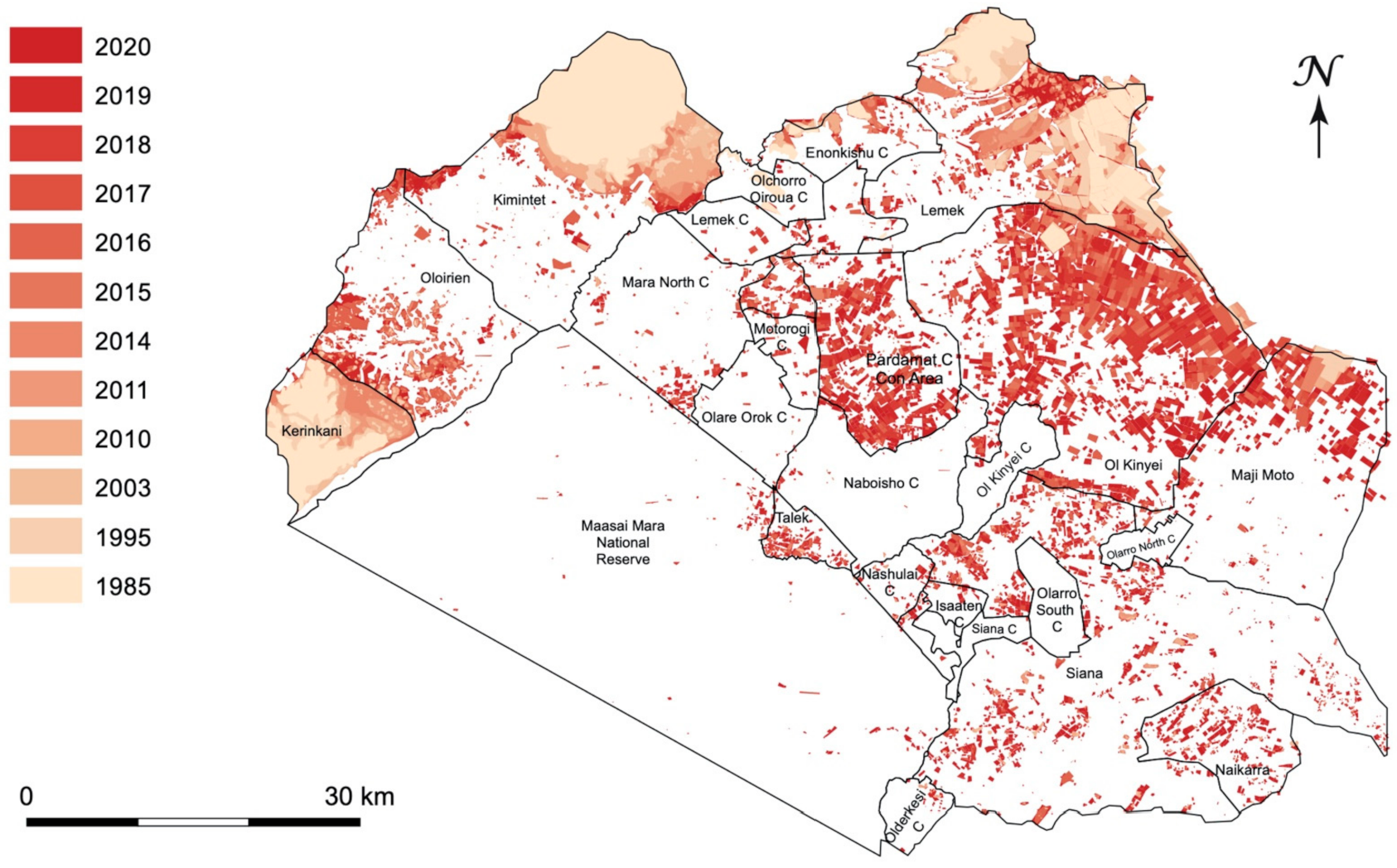
Grids Spreading across the Grazing Lands

In the early 19th century, the Maasai territories covered a vast area of Kenya and became known as Maasai land [80] (p. 84). In 1904 and 1911, a contentious process of coercion by the colonial government forced Maasai leaders to sign two Maasai Agreements, in which they agreed to leave their northern territories and instead receive state-acknowledged exclusive rights to the Southern Maasai Reserve [77]. Colonial administrators marked the Southern Maasai Reserve, and its boundary, as a Native Reserve on the cartographic maps. Given this categorization, the colonial era in the Mara was different than in Laikipia. Here, land use under customary tenure in ethnic-based territories continued. This made enclosure and formal ownership unnecessary or seem irrational in relation to pastoralist livelihoods [93].
However, during the colonial period, interest in the area grew. Despite the legality of the Maasai Agreements, the colonial administration started to disregard their promise of Maasai autonomy of the Reserve. Archival documents disclose that fence constructions, farming and settlement by non-Maasai groups were authorized by the colonial administration. National parks were cut off from the Reserve on the cartographic maps, creating zones in which wildlife, hunting and tourism were favoured over Maasai settlement [108,109,110]. Frustration grew, and in a letter from Maasai representatives in 1961, they argue: “[the Colonial and British Governments] have relentlessly pursued a policy of extraction towards what was left of the Maasai lands, which have been systematically parcelled out as game reserves and national parks” [111]. These violations of the agreement have been widely recognized by scholars today [77,112].
In 1962, on the eve of Independence, the British administration sought to altogether disregard the legal commitment of the Maasai Agreements to prevent a situation in which the Maasai population could reassume sovereignty of all the territories they gave up in 1911, areas that had since been allotted for enclosed farming and ranching as in Laikipia [113]. In relation to the Lancaster House Conference, the British Government concluded that since there was ... nothing in [the Maasai] agreement which can be relied on as suggesting that the Masai retained a reversionary right in the land if the Europeans no longer needed it..., they were not legally obliged to honour the 1904 and 1911 agreements upon their exit, although it could be argued that they were morally obliged to do so [114].
Even though the idea of reversionary rights continued to hold validity among the Maasai, the Independent Kenyan Government did not challenge the position, and the judgement officially undermined Maasai sovereignty over the unfenced range. Not long afterwards, the land was privatized and enclosed by legal boundaries surrounding conservancies and group ranches which could be allocated to Maasai and non-Maasai alike. This process was motivated by a liberal political agenda in the independent state to counter environmental degradation and commercialize livestock production [78,115]. Paradoxically, in a bid to keep the land in Maasai hands, Maasai groups partook in the gridding process themselves by acquiring group ranches. By 1979, 57 group ranches had been established, turning the Greater Mara into a legally gridded landscape of privatized units [78]. The tendency towards privatization increased as group ranch members called for individual title deeds. However, according to one of the Mara pastoralists, land sales were done in secret because “No Maasai like to see land sold,” and they feared that if a sale was advertised the land could go to a non-Maasai [116].
Inquiring further into the pace and magnitude of the succeeding spread of land tenure fencing, Figure 3 shows that a series of townships were already extensively fenced in the 1980s. In the following decades, fences surrounding smallholder plots were sometimes raised outside these areas, which Lamprey and Reid primarily ascribe to outsiders [79]. However, in 2014, the area saw a major increase in fenced land plots, now spreading across much larger areas, including common range lands situated far from the townships [81] (p. 3). The average smallholder plot size is c. 0.6 square kilometres, and the fences are typically constructed using barbed or electric wire.
Hence, in the Greater Mara, fencing has increased far more rapidly and recently than in Laikipia and is based on different power dynamics. Although there have been several political attempts to keep fences outside conservancies and effectively manage their proliferation, the trend of exponentially spreading fences appears to be continuing. Since 2014, a contiguous front of fenced land has been forming across Siana, the boundaries between Siana, Ol Kinyei and Maji Moto, and along the eastern border of the Nashulai Conservancy.
Fencing is supported in many Mara communities, and many people refer to enclosed plots as a form of ‘grass banks’ to which they can retreat with their livestock when grazing has been depleted in the group ranches and conservancies [117] (p. 396). However, as Esther Mwangi argues, the new system only benefits everyone when grazing is abundant. It is, however, highly volatile when grass is exhausted on the private shares and the fencing is therefore skewed to favour the wealthier pastoralists with larger individual grass banks or a diversified income with less dependency on the livestock [78] (p. 903).
One elder argued that the fencing is not a sign that the Mara pastoralists are fundamentally changing their pastoralist principles, which are based on morality and mobility. “If possible, many would re-expand their herds”, he said [118]. This may be a reference to how group ranches function in Kajiado, about 250 kilometres south-east of the Mara, where land has been similarly privatized, although fencing is still avoided. As a moral codex, it is acceptable to cross someone else’s land with livestock in Kajiado when moving towards other pastures [78,119].
Taking into consideration the Mara pastoralists’ shared history of marginalization, violation of agreements and the enduring idea of having a reversionary right to their previous territories, their wide support of fencing is not surprising. It appears to reflect a continuing struggle to protect Mara pastoral livelihoods, as did their efforts to hinder land appropriation during the colonial era [78] (p. 890). Even though pastoral livelihoods depend on large-scale accessible grazing, they are still compelled to support its fencing to regain land autonomy and tackle the risk of losing land access to outsiders. This means that pastoralists are caught in a catch-22 situation. Paradoxically, the history of marginalization continues to drive the defensive strategies of fencing privatized land, just as it drove the Mara pastoralists’ anti-privatization agenda during colonization.

4. Discussion

The cases presented above offer two examples of the perpetuating trajectories of post-colonial landscape gridding, including the creation of lined maps where continuous landscapes once prevailed. Somehow, once these landscape logics are mattered and turned into fences, it is difficult to avoid, ignore or move beyond their ramifications of separation, striation, enclosure, exclusion, and imposition of political, social and species hierarchies on the landscape through ownership or fencing. Hence, the imperial debris of colonial structures of dominance is repeatedly carried forward into a vast entangled web of infrastructures in new iterations, creating conceptual and material inertia in its midst.
The ranchers’ landscape presence is inextricably bound to colonial history regardless of whether they are newcomers or third-generation colonial settlers. Their relation to land cannot be separated from the imperial debris of colonial settlement. It is even carried forward by conservancy initiatives that have contributed to the physical enclosure of conservation areas, encroaching onto grasslands through tourism investments or by protecting the free roaming of wildlife [120]. It can also be seen in the removal of smallholder fences in return for leasing fees, as in Loliondo [121]. Such initiatives continue to build on colonial logics that, Stoler argues, cannot simply be undone through efforts of decolonization such as land reforms [74]. Rather, when confirming the principles of gridding and enclosure, for instance, by physically confining cattle grazing to designated areas and farming to others, they extend the reach of the colonial power relations once again. Even in the present study of de-/fencing, we ourselves are guilty of enforcing a trend of white Western scholars prying in issues of land tenure, management and conservation in African countries; as well as, by presenting maps of fencing dynamics that may add fuel to the fire and, unintendedly, inflate more claims and more fences.
We wonder whether the gridding also reflect a particular mode of spatialization [56]: A logic of landscaping, based on principles of striation and exclusion, that is particularly problematic when it clashes with one based on access and reciprocity.
In spaces of mobile pastoralist livelihoods, large grazing areas are often operated by shared norms, morals, and networks based on access, commoning or open access property [16,122]. The seasonal use of large areas functions well in (semi-) arid zones, where grazing, water and salt licks can easily be overused [123,124]. Without rotational use and relatively high mobility, the limited and enclosed pastures risk depleting resources through overgrazing and soil erosion [125,126,127]. A clash between this and the landscape logic of gridding carries very concrete, physical consequences for how humans and animals navigate landscapes and futures.
The grid reflects a sedentary, striated space in which land can be owned, possessed, appropriated and enclosed, and people can be owners, possessors, appropriators and enclosers. This line of thought is hinged on John Locke’s initial ideology of property that has since then developed into principles for privatization: “Every man has a property in his own person. This nobody has any right to but himself. The labor of his body, and the work of his hands, we may say, are properly his” [128] (p. 12). Through the lens of this sedentary logic, the fence appears to be an incontestable given. For example, one of the Laikipia ranchers held that trespassing onto his land must be due to a systematic flaw [98]. It is this exact logic, hinged on boundaries, that material fences reinforce: a logic of exclusion and restriction rather than of ensuring and facilitating access. Thus, no matter what the underlying motivation for constructing fences is, they inadvertently hinder landscaping based on access and mobility, and its associated moral norms of use and mobility strategies for mitigating risks of resource scarcity. When the claims change from merely existing on a map to materializing as fences, whether around a common, a conservancy or a private plot of land, they may ignite a range of unintended consequences, such as conflict inertia and escalation. Boundaries may also produce additional boundaries in the proximity, with fundamental consequences for excluded users which may (given the inherent inflammatory nature of the situation) become near irreconcilable and irrevocable.

4.1. Perspective: From Current Fences to Prehistoric Fieldscapes

The logics of the landscape grid are reflected in countless applications through history connected to the occupation and confiscation of land, such as the 18th–19th century American Great Plains and Australia, or the 15th–17th century rise of agriculture and industry in Britain and Europe as mentioned in Section 1.3 [129,130,131,132,133]. Bronze Age examples include the stone-walled landscapes of Ireland and Britain and the terraced walls of the Mediterranean [134,135,136]. We believe our case studies from Kenya can provide a meaningful perspective on the underlying temporal and socio-organizational complexity of such (pre-)historic, relict landscapes, and their long-term dynamics of exclusion and social provocations.
One particularly intriguing comparative case is the enclosure of pastoral grasslands and heathlands in late prehistoric Northern Europe. Large-scale parcelled out3 landscapes have been discovered on aerial photos, LiDAR, and in excavations and field surveys of areas spanning thousands of hectares [137]. Like Laikipia and Mara, these landscapes were used as extensive grazing land for centuries prior to enclosure. These extensive grid-like landscapes already covered 70–75% of the available land in the Early Iron Age [138,139]. The boundaries were allotted so that they incorporated previous landscape markers. Chronological sequences suggest that boundaries were sometimes continually reshaped and accumulated across more than 800 years, not unlike the English hedges [140]. Fences also enclosed individual farmsteads, villages and defensive sites [141]. Across centuries, fences were turned into formalized cultural symbols of private spheres and property rights. Intriguingly, once these fences were instantiated in the landscape and embedded in more widely accepted cultural norms and regulatory principles, (recti)linear enclosure continued to be used as the preferred means of land confiscation.
These landscapes show how difficult it is to get rid of boundaries once they are inscribed physically in the landscape and conceptually in people’s minds and practices, reflecting the somewhat frozen end-product of at least 800 years of boundary drawing and mattering.
Still, in some crucial respects, we know very little about (pre)historic landscape gridding: we can often only observe the last phase of century-long processes of land enclosure, making its pace and dynamics difficult to capture. Thus, the causes of their initial materialisation and expansion are often attributed to agrarian intensification. Moreover, it remains difficult to entangle any conflicting forms of social organization. Fences could have been torn down, trespassed or knocked over without us being able to detect it archaeologically, however, multiple phases of rebuilding and fortification do suggest instances of boundary contestation.
In this respect, our cases from Kenya provide a much finer resolution to the temporal, economic and socio-political (un)becoming of (pre-)historic enclosed landscapes than that obtained from the archaeological material.
First, in terms of the temporality of mattering, some of these processes are extremely rapid and happens within a generation, as the fencing has in Mara. However, the very mattering of boundaries, although partially reflecting an underlying mapped ‘grid’ is also something that happens on a piecemeal basis, as is the case for the Thome-Ngorare ranch boundary, which in long periods were only guarded and not fenced. Moreover, both cases involve long periods during which fencing was considered unnecessary or unthinkable.
Second, in terms of economic incentives, our cases reflect the fact that fencing is not solely or primarily incentivized by agrarian intensification, as is assumed in much archaeological literature. Rather, in Mara, it is deeply associated with pastoral strategies, although it is not necessarily compatible with such livelihoods in the long run. Simply because the intensification of landscape fencing overrules their very socio-organisational principles of e.g., access, reciprocity and mobility/transhumance [125,126], whereas cultivation itself is yet another type of boundary-making and land binding. Both cases show how difficult it is to identify archaeological and historical traces of pastoralists. In addition, they direct our attention to the fact that one economy is not necessarily simply succeeded by another economy. Instead, they ask questions of the archaeological material: What if it was simply agricultural farmers that became more visible in the material? What if several competing economic user groups continued to live side by side? What if the violent conflicts escalating in southern Scandinavia by the start of the Iron Age are related to conflicts between different user groups, with different logics of spatial use, and the associated rise in physical linear boundaries?
Third, our cases point towards the importance of following how the morphology of boundaries is entangled in underlying power dynamics; in which historical situations and contexts a fence is preferred over a conceptual or otherwise imaginary boundary. Moreover, they show how fences are used as technologies of empowerment (and marginalization) rather than merely reflecting the most logical means of landscape regulation.In the case of Mara, where fences are still relatively novel and less disputed, the fences are rarely constructed in elaborate dimensions, although stone enclosures have begun to trend in some areas. However, in Laikipia, the far more elaborate dimensions of the ranch boundaries, and the various attempts to transgress them, offer an obvious point of departure for studying moments of dispute embedded in prehistoric gridded landscapes. We can use these insights to sharpen our awareness of archaeological traces of contestation and demolition of land boundaries and their associated economies of violence.

5. Conclusions

In this article, we enquired into the historical and material trajectories of land enclosure in Kenya, and the kind of realities of political and ecological uncertainty and unpredictability in which people will have to operate in the future.
In terms of the latter, the Mara pastoralists’ use of fencing may depend on a continued availability of spaces of openly accessible grazing land. Pastoralists with small land plots can get by with the use of common grazing areas and grazing agreements with conservancies, only using their private plots when other resources have been depleted. If the spread of fencing continues with the pace and magnitude of the last decade, the long-term consequences will refer grazing to increasingly restricted areas. While fences fill in landscapes, and grazing restrictions are set within (still unfenced) conservancies, the dependency on the commons may sooner or later push these hybrid pastoral practices to a point where their grazing practices are no longer compatible with a fully fenced landscape. This dependence on unenclosed grazing areas is also relevant in Laikipia itself, as pastoralists depend on grazing inside ranches. As long as the fences are ‘de-fencible’, the ranches can in principle continue to function as open access grazing. However, as soon as fences turn into de-facto physical boundaries, the pastoralists’ strategies for grazing face a serious dilemma. Indeed, grazing in common areas, so important for the viability of enclosed parcels used for cultivation or pasture, will be impossible if those areas are all fenced or prohibited by other forms of enclosure, e.g. conservation.
In Laikipia, some pastoralists have started to purchase land to secure their access to grazing. However, they have no appetite for fencing [104,142,143]; at least not yet. Fencing appears unnecessary given the fact that their plots are so small that they must still trespass onto the ranch lands to find adequate grazing. However, should the Ngorare fences become impossible to transgress, their de-facto access to the ‘grass bank’ beyond Ngorare’s fences would end. In such a scenario, fencing around the individual plots, such as in Mara, could start to occur so owners can prioritize grass for their own livestock. However, for now, the perpetual battle of de-/fencing Ngorare’s boundary continues.
Moreover, both the Laikipia pastoralists’ purchasing of land plots as well as the Mara pastoralists’ reference to grass banks signify an economized approach to the landscape as a striated resource that can be tapped, a time where other fencing is making land previously used as commons unavailable. Laikipia is occasionally even referred to as an ATM by pastoralists from surrounding areas of Wamba, Isiolo, Dol dol and Churo, both in the sense of a place to which one can easily bring one’s livestock and withdraw it when needed and with reference to the ease with which one can withdraw (meaning steal or raid) cattle from ranches [144].
The spread of fences in Mara and Laikipia, which commenced at different points in time and at different paces, represents two points along the mattering of land privatization boundaries. We propose that some of the conflicts escalating over these boundaries are not only embedded in questions of claiming or protecting land, crops and cattle, but that fences represent a particular mode of spatialization, a slow violence, which is deeply embedded in unsettled imperial debris. Our study adds the material strategies and agency of de-/fencing to previous accounts on how pastoral communities dynamically manage and monitor the use of land to fit political and environmental challenges to their land access [145,146,147,148,149]. Moreover, the two cases shed light on several intriguing paradoxes associated with the long-term repercussions of enclosure which are well worth exploring further in future research. This research could focus on the complex lodging of fencing in layers of political pasts, their manifestations as acts of both autonomy and struggle that continuously shape the landscape, and the long-term consequences of claiming land by creating horizontal boundaries on maps and then turning them into vertical fences in the landscapes.

Author Contributions

Conceptualization, M.L. and M.L.G.; methodology, M.L. and M.L.G.; validation, M.L. and M.L.G.; formal analysis, M.L. and M.L.G.; investigation, M.L. and M.L.G.; resources, M.L. and M.L.G.; data curation, M.L. and M.L.G.; writing—original draft preparation, M.L. and M.L.G.; wri-ting—review and editing, M.L. and M.L.G.; visualization, M.L. and M.L.G.; project administration, M.L.; funding acquisition, M.L. All authors have read and agreed to the published version of the manuscript.

Funding

The project has received funding from the European Research Council (ERC) under the European Union’s Horizon 2020 research and innovation programme (grant agreement No. 853356), and two generous seeds from the Interacting Minds Centre (IMC) and Aarhus University Research Foundation (AUFF).

Data Availability Statement

The data presented in this study is available on request from the corresponding author. Exceptions are the personal details of the qualitative interviews. For ethical reasons and in accordance with GDPR, personal details of this data are withheld by the authors. Other qualitative data is available on request. The fencing data is partly available (1985–2016) from the ‘Landscape Dynamics database landDX’ (https://www.landdx.com accessed on 5 March 2021) (Tyrrell et al., 2021). The remaining data are not publicly available due to ongoing research activities.

Acknowledgments

We are very thankful to friends and colleagues who have read and commented upon previous drafts and versions of this paper: Eric Kioko at Kenyatta University, Irene Amoke at Kenya Wildlife Trust, Lotte Meinert at Aarhus University, Maya Pasgaard at Aarhus University, Paul Lane at University of Cambridge and Ulrika Waaranperä at Malmö University and, in particular, Mikkel Funder at DIIS. A special thanks to Evans Muriu, who has assisted us in acquiring and confirming the accuracy of qualitative data from Laikipia. Moreover, a warm thanks to the Maasai Mara Science and Development Initiative.

Conflicts of Interest

The authors declare no conflict of interest.

Notes

1
The White Highlands was the popular term for a large tract of land designated as Crown Land on which only white settlers were granted holder rights.
2
Often a politician would sell share certificates to more shareholders than the land could hold because providing land could directly be translated into politi-cal support. Buyers would often support the politician despite the fact that over-selling made it impossible for them to acquire individual title deeds. This was of little consequence if the buyers did not intend to settle. However, for those without land elsewhere, it meant a tenure insecurity deadlock [92].
3
Large-scale parcelled out landscape slso known as Celtic fields, characterized by enclosed rectangular plots, linear axes, ladder-like arrangements and compounds spanning thousands of hec-tares delimited only by natural boundaries [72].

References

  1. McInturff, A.; Xu, W.; Wilkinson, C.E.; Dejid, N.; Brashares, J.S. Fence ecology: Frameworks for understanding the ecological effects of fences. BioScience 2020, 70, 971–985. [Google Scholar] [CrossRef]
  2. Barad, K.M. Posthumanist performativity: Toward an understanding of how matter comes to matter. Signs J. Women Cult. Soc. 2003, 28, 801–831. [Google Scholar] [CrossRef] [Green Version]
  3. Kashululu, R.M.P.; Hebinck, P.G.M. The fencing question in Namibia: A case study in Omusati Region. In Neither Here nor There: Indigeneity, Marginalisation and Land Rights in Post-Independence Namibia; Legal Assistance Centre: Windhoek, Namibia, 2020; pp. 163–183. [Google Scholar]
  4. Nixon, R. Slow Violence and the Environmentalism of the Poor; Harvard University Press: Cambridge, MA, USA; London, UK, 2003. [Google Scholar]
  5. Katz, C. Whose nature, whose culture? Private productions of space and the “preservation” of nature. In Remaking Reality: Nature at the Millenium; Braun, B., Castree, N., Eds.; Routledge: London, UK, 1998; pp. 45–62. [Google Scholar]
  6. Waller, R.D. Interaction and identity on the periphery: The Trans-Mara Maasai. Int. J. Afr. Histor. Stud. 1984, 17, 243–284. [Google Scholar] [CrossRef]
  7. Leo, C. Land and Class in Kenya; University of Toronto Press: Toronto, ON, Canada, 1984; Volume 3. [Google Scholar]
  8. Anderson, D.; Throup, D. Africans and agricultural production in colonial Kenya: The myth of the war as a watershed. J. Afr. Hist. 1985, 26, 327–345. [Google Scholar] [CrossRef]
  9. Anderson, D. Depression, dust bowl, demography, and drought: The colonial state and soil conservation in East Africa during the 1930s. Afr. Affairs 1984, 83, 321–343. [Google Scholar] [CrossRef]
  10. Berman, B.; Lonsdale, J. Unhappy Valley: Conflict in Kenya and Africa; Ohio University Press: Athens, OH, USA, 1992. [Google Scholar]
  11. Moore, D.S. Marxism, culture, and political ecology. Environmental struggles in Zimbabwe’s Eastern Highlands. In Liberation Ecologies: Environment, Development, Social Movements; Peet, R., Watts, M., Eds.; Routledge: London, UK, 1996; pp. 125–147. [Google Scholar]
  12. Throup, D.; Hornsby, C. Multi-Party Politics in Kenya: The Kenyatta & Moi States & the Triumph of the System in the 1992 Election; Ohio University Press: Athens, OH, USA, 1998. [Google Scholar]
  13. Anderson, D. Eroding the Commons: The Politics of Ecology in Baringo, Kenya, 1890s–1963; James Currey Publishers: Oxford, UK, 2002. [Google Scholar]
  14. Kanyinga, K. The legacy of the white highlands: Land rights, ethnicity and the post-2007 election violence in Kenya. J. Contemp. Afr. Stud. 2009, 27, 325–344. [Google Scholar] [CrossRef]
  15. Spencer, P. Nomads in Alliance: Symbiosis and Growth among the Rendille and Samburu of Kenya; Oxford University Press: London, UK, 2012. [Google Scholar]
  16. Bollig, M.; Bubenzer, O. (Eds.) African Landscapes: Interdisciplinary Approaches; Springer Science & Business Media: New York, NY, USA, 2009. [Google Scholar]
  17. McCabe, J.T. Cattle Bring Us to Our Enemies: Turkana Ecology, Politics, and Raiding in a Disequilibrium System; University of Michigan Press: Ann Arbor, MI, USA, 2010. [Google Scholar]
  18. Straight, B.; Lane, P.; Hilton, C.; Letua, M. “Dust people”: Samburu perspectives on disaster, identity, and landscape. J. East. Afr. Stud. 2016, 10, 168–188. [Google Scholar] [CrossRef]
  19. Boles, O.J.C.; Shoemaker, A.; Mustaphi, C.; Petek, N.; Ekblom, A.; Lane, P.J. Historical ecologies of pastoralist overgrazing in Kenya: Long-term perspectives on cause and effect. Hum. Ecol. 2019, 47, 419–434. [Google Scholar] [CrossRef] [Green Version]
  20. Ekblom, A.; Lane, P.; Sinclair, P. Reconstructing African landscape historical ecologies. In Historical Ecologies, Heterarchies and Transtemporal Landscapes, 1st ed.; Ray, C., Fernández-Götz, M., Eds.; Routledge: London, UK, 2019. [Google Scholar] [CrossRef]
  21. Marchant, R.; Lane, P. Past perspectives for the future: Foundations for sustainable development in East Africa. J. Archaeol. Sci. 2014, 51, 12–21. [Google Scholar] [CrossRef]
  22. Armstrong, C.G.; Shoemaker, A.C.; McKechnie, I.; Ekblom, A.; Szabó, P.; Lane, P.J.; McAlvay, A.C.; Boles, O.J.; Walshaw, S.; Petek, N.; et al. Anthropological contributions to historical ecology: 50 questions, infinite prospects. PLoS ONE 2017, 12, e0171883. [Google Scholar] [CrossRef]
  23. Lund, C.; Boone, C. Introduction: Land politics in Africa—Constituting authority over territory, property and persons. Africa 2013, 83, 1–13. [Google Scholar] [CrossRef] [Green Version]
  24. Peters, P.E. Challenges in land tenure and land reform in Africa: Anthropological contributions. World Dev. 2009, 37, 1317–1325. [Google Scholar] [CrossRef]
  25. Berry, S.S. Debating the land question in Africa. Comp. Stud. Soc. Hist. 2002, 44, 638–668. [Google Scholar] [CrossRef]
  26. Leys, C. Underdevelopment in Kenya; East African Publishers: Nairobi, Kenya, 1975. [Google Scholar]
  27. Little, P.D.; Watts, M. (Eds.) Living under Contract: Contract Farming and Agrarian Transformation in Sub-Saharan Africa; University of Wisconsin Press: Athens, OH, USA, 1994. [Google Scholar]
  28. Benjaminsen, T.A. Formalising land tenure in rural Africa. Forum Dev. Stud. 2002, 29, 362–366. [Google Scholar] [CrossRef]
  29. Peters, P.E. Inequality and social conflict over land in Africa. J. Agrar. Change 2004, 4, 269–314. [Google Scholar] [CrossRef]
  30. Manji, A.S. The Politics of Land Reform in Africa: From Communal Tenure to Free Markets; Zed Books: London, UK, 2006. [Google Scholar]
  31. Lund, C. Rule and rupture: State formation through the production of property and citizenship. Dev. Chang. 2016, 47, 1199–1228. [Google Scholar] [CrossRef] [Green Version]
  32. Peters, P.E. Land appropriation, surplus people and a battle over visions of agrarian futures in Africa. J. Peasant Stud. 2013, 40, 537–562. [Google Scholar] [CrossRef]
  33. Klopp, J.M. Pilfering the public: The problem of land grabbing in contemporary Kenya. Afr. Today 2000, 47, 7–26. [Google Scholar] [CrossRef]
  34. Joireman, S.F. Where There Is No Government: Enforcing Property Rights in Common Law Africa; Oxford University Press: Oxford, UK, 2011. [Google Scholar]
  35. Lund, C. Local Politics and the Dynamics of Property in Africa; Cambridge University Press: New York, NY, USA; Cambridge, UK, 2008. [Google Scholar]
  36. Sikor, T.; Lund, C. Access and property: A question of power and authority. Dev. Chang. 2009, 40, 1–22. [Google Scholar] [CrossRef] [Green Version]
  37. Berry, S.S. No Condition is Permanent: The Social Dynamics of Agrarian Change in Sub-Saharan Africa; University of Wisconsin Press: Madison, WI, USA, 1993. [Google Scholar]
  38. Shipton, P.M. Mortgaging the Ancestors: Ideologies of Attachment in Africa; Yale University Press: New Haven, CT, USA, 2009. [Google Scholar]
  39. Peters, P.E.; Kambewa, D. Whose security? Deepening social conflict over ‘customary’ land in the shadow of land tenure reform in Malawi. J. Modern Afr. Stud. 2007, 45, 447–472. [Google Scholar] [CrossRef] [Green Version]
  40. Mackenzie, F. ‘A piece of land never shrinks’: Reconceptualizing land tenure in a small-holding district. In Land in African Agrarian Systems; Basset, T.J., Crummey, D.E., Eds.; University of Wisconsin Press: Athens, OH, USA, 1993; pp. 194–221. [Google Scholar]
  41. Anderson, D.; Lochery, E. Violence and exodus in Kenya’s rift valley, 2008: Predictable and preventable? J. East. Afr. Stud. 2008, 2, 328–3433. [Google Scholar] [CrossRef]
  42. Gravesen, M.L. The Contested Lands of Laikipia: Histories of Claims and Conflict in a Kenyan Landscape; Brill: Leiden, The Netherlands, 2020. [Google Scholar]
  43. Carrier, N. Reviving Yaaku: Identity and indigeneity in northern Kenya. Afr. Stud. 2011, 70, 246–263. [Google Scholar] [CrossRef]
  44. Hodgson, D.L. Precarious alliances: The cultural politics and structural predicaments of the indigenous rights movement in Tanzania. Am. Anthropol. 2002, 104, 1086–1097. [Google Scholar] [CrossRef]
  45. Lynch, G. Kenya’s new indigenes: Negotiating local identities in a global context. Nations Natl. 2011, 17, 148–167. [Google Scholar] [CrossRef]
  46. Lynch, G. Becoming indigenous in the pursuit of justice: The African Commission on Human and Peoples’ Rights and the Endorois. Afr. Aff. 2012, 111, 24–45. [Google Scholar] [CrossRef]
  47. Evans, L.; Adams, W. Fencing elephants: The hidden politics of wildlife fencing in Laikipia. Kenya Land Use Policy 2016, 51, 215–228. [Google Scholar] [CrossRef] [Green Version]
  48. Durant, S.M.; Becker, M.S.; Creel, S.; Bashir, S.; Dickman, A.J.; Beudels-Jamar, R.C.; Lichtenfeld, L.; Hilborn, R.; Wall, J.; Wttemyer, G.; et al. Developing fencing policies for dryland ecosystems. J. Appl. Ecol. 2015, 52, 544–551. [Google Scholar] [CrossRef]
  49. Brockington, D.; Duffy, R.; Igoe, J. Nature Unbound: Conservation, Capitalism and the Future of Protected Areas; Earthscan: London, UK, 2008. [Google Scholar]
  50. Ferguson, K.; Hanks, J. The effects of protected area and veterinary fencing on wildlife conservation in southern Africa. Parks 2012, 18, 49–60. [Google Scholar]
  51. Kioko, J.; Muruth, P.; Omondi, P.; Chiyo, P.I. The performance of electric fences as elephant barriers in Amboseli, Kenya. South Afr. J. Wildlife Res. 2008, 38, 52–58. [Google Scholar] [CrossRef]
  52. Spierenburg, M.; Wels, H. “Securing Space”: Mapping and fencing in transfrontier conservation in Southern Africa. Space Cult. 2006, 9, 294–312. [Google Scholar] [CrossRef]
  53. Brockington, D. Fortress Conservation: The Preservation of the Mkomazi Game Reserve, Tanzania; James Currey: Oxford, UK, 2002. [Google Scholar]
  54. Veldhuis, M.P.; Ritchie, M.E.; Ogutu, J.O.; Morrison, T.A.; Beale, C.M.; Estes, A.B. Cross-boundary human impacts compromise the Serengeti-Mara ecosystem. Science 2019, 363, 1424–1428. [Google Scholar] [CrossRef] [Green Version]
  55. Woodhouse, P.; Bernstein, H.; Hulme, D. African Enclosures? The Social Dynamics of Wetlands in Drylands; James Currey: Oxford, UK, 2000. [Google Scholar]
  56. Deleuze, G.; Guattari, F. Tusinde Plateauer: Kapitalisme og Skizofreni; Det Kongelige Danske Kunstakademis Billedkunstskoler: Copenhagen, Denmark, 2005. [Google Scholar]
  57. Barad, K.M. Meeting the Universe Halfway: Quantum Physics and the Entanglement of Matter and Meaning; Duke University Press: Durham, UK, 2007. [Google Scholar]
  58. Løvschal, M. Emerging boundaries: Social embedment of landscape and settlement divisions in northwestern Europe during the first millennium BC. Curr. Anthropol. 2014, 55, 725–750. [Google Scholar] [CrossRef]
  59. Larsen, S.E. Gadens rum—Byens grænse. In Grænse; Stjernfelt, F., Troelsen, A., Eds.; Aarhus University Press: Aarhus, Denmark, 1992; pp. 104–132. [Google Scholar]
  60. Deleuze, G. Difference and Repetition; Columbia University Press: London, UK, 1994. [Google Scholar]
  61. Fabian, J. Time and the Other: How Anthropology Makes Its Object; Columbia University Press: New York, NY, USA, 2014. [Google Scholar]
  62. Zerubavel, E. The Fine Line: Making Distinctions in Everyday Life; Free Press: New York, NY, USA, 1991. [Google Scholar]
  63. Campbell, D.J. Land as ours, land as mine: Economic, political and ecological marginalization in Kajiado District. In Being Maasai: Ethnicity and Identity in East. Africa; Spear, T., Waller, R., Eds.; James Currey: London, UK, 1993; pp. 258–272. [Google Scholar]
  64. Ingold, T. Lines: A Brief History; Routledge: London, UK, 2007. [Google Scholar]
  65. Ingold, T. The Life of Lines; Routledge: London, UK, 2015. [Google Scholar]
  66. Zerubavel, E. Lumping and splitting. Sociol. Forum 1996, 11, 549–561. [Google Scholar] [CrossRef]
  67. Smith, B. On drawing lines on a map. In International Conference on Spatial Information Theory; Frank, A.U., Kuhn, W., Eds.; Springer: Berlin/Heidelberg, Germany, 1995; pp. 475–484. [Google Scholar]
  68. Smith, B. Boundaries: An essay in mereotopology. In The Philosophy of Roderick; Chisholm (Library of Living Philosophers); Hahn, L.H., Ed.; Open Court: Chicago, IL, USA, 1997; pp. 534–561. [Google Scholar]
  69. Smith, B.; Varzi, A.C. Fiat and bona fide boundaries. Phil. Phenomenol. Res. 2000, 60, 401–420. [Google Scholar] [CrossRef] [Green Version]
  70. Kronenburg García, A.; van Dijk, H. Towards a theory of claim making: Bridging access and property theory. Soc. Nat. Resour. 2020, 33, 167–183. [Google Scholar] [CrossRef]
  71. Blomley, N. Making private property: Enclosure, common right and the work of hedges. Rural Hist. 2007, 18. [Google Scholar] [CrossRef] [Green Version]
  72. Løvschal, M. From neural synapses to culture-historical boundaries: An archaeological comment on the plastic mind. J. Cognit. Cult. 2014, 14, 415–434. [Google Scholar] [CrossRef]
  73. Løvschal, M. The logics of enclosure: Deep-time trajectories in the spread of land tenure boundaries in late prehistoric northern Europe. J. R. Anthropol. Inst. 2020, 26, 365–388. [Google Scholar] [CrossRef]
  74. Stoler, A.L. Imperial debris: Reflections on ruins and ruination. Cult. Anthropol. 2008, 23, 191–219. [Google Scholar] [CrossRef]
  75. Fanon, F. The Wretched of the Earth; Grove Press: New York, NY, USA, 1963. [Google Scholar]
  76. Moore, D.S. Suffering for Territory: Race, Place, and Power in Zimbabwe; Duke University Press: Durham, London, UK, 2005. [Google Scholar]
  77. Hughes, L. Moving the Maasai: A Colonial Misadventure; Palgrave Macmillan: Basingstoke, UK; New York, NY, USA, 2006. [Google Scholar]
  78. Mwangi, E. The puzzle of group ranch subdivision in Kenya’s Maasailand. Dev. Chang. 2007, 38, 889–910. [Google Scholar] [CrossRef]
  79. Lamprey, R.H.; Reid, R.S. Expansion of human settlement in Kenya’s Maasai Mara: What future for pastoralism and wildlife? J. Biogeogr. 2004, 31, 997–1032. [Google Scholar] [CrossRef]
  80. Waller, R.D. Tsetse fly in western Narok, Kenya. J. Afr. Hist. 1990, 31, 81–101. [Google Scholar] [CrossRef]
  81. Løvschal, M.; Bøcher, P.K.; Pilgaard, J.; Amoke, I.; Odingo, A.; Thuo, A.; Svenning, J.C. Fencing bodes a rapid collapse of the unique Greater Mara ecosystem. Sci. Rep. 2017, 7. [Google Scholar] [CrossRef] [Green Version]
  82. Løvschal, M.; Nørmark, M.J.; Svenning, J.-C.; Wall, J. Still More Fences in the Greater Mara. Sci. Rep. In Preparation.
  83. Tyrell, P.; Betjes, K.; Broekhuis, F.; Buitenwerf, R.; Carroll, S. Landscape Dynamics (landDX) database: An integrated open-access spatial-temporal database for conservation and rangeland management in the Kenya-Tanzania borderlands. Nat. Sci. Data 2021, (in press). [Google Scholar]
  84. Lane, P.J. An outline of the later Holocene archaeology and precolonial history of the Ewaso Basin, Kenya. In Conserving Wildlife in African Landscapes: Kenya’s Ewaso Ecosystem; Georgiadis, N.J., Ed.; Smithsonian Institute for Scholarly Press: Washington, DC, USA, 2011; pp. 11–30. [Google Scholar]
  85. Robertshaw, P. Early Pastoralists of South-Western Kenya; The British Institute of East Africa: Nairobi, Kenya, 1990. [Google Scholar]
  86. Ogot, B.A. (Ed.) Kenya before 1900; East African Publishing House: Nairobi, Kenya, 1976. [Google Scholar]
  87. Lane, P. Trajectories of pastoralism in northern and central Kenya: An overview of the archaeological and environmental evidence. In Pastoralism in Africa: Past, Present and Future; Bollig, M., Schnegg, M., Wotzka, H.P., Eds.; Berghahn: New York, NY, USA, 2013; pp. 104–144. [Google Scholar]
  88. Dewees, P.A. Trees and farm boundaries: Farm forestry, land tenure and reform in Kenya. Africa 1995, 65, 217–235. [Google Scholar] [CrossRef] [Green Version]
  89. Scott, J.C. The Art of Not Being Governed; Yale University Press: New Haven, CT, USA, 2009. [Google Scholar]
  90. Fratkin, E. The Samburu laibon’s sorcery and the death of Theodore Powys in colonial Kenya. J. East. Afr. Stud. 2015, 9, 35–54. [Google Scholar] [CrossRef]
  91. Wasserman, G. Politics of Decolonization: Kenya Europeans and the Land Issue; Cambridge University Press: Cambridge, UK, 1976. [Google Scholar]
  92. Gravesen, M.L. Twilight Institutions: Land-buying Companies & their Long-term Implications in Laikipia, Kenya. In Land, Investment & Politics Reconfiguring Eastern Africa’s Pastoral Drylands; Lind, J., Okenwa, D., Scoones, D., Eds.; James Currey/Boydell & Brewer Incorporated: Woodbridge, UK, 2020; pp. 144–154. [Google Scholar]
  93. Sorrenson, M.P.K. Origins of European Settlement in Kenya; Oxford University Press: Nairobi, Kenya, 1968. [Google Scholar]
  94. Interview with informant JT. undertaken in Laikipia on 27 May 2015.
  95. Interview with informant E. undertaken in Laikipia on 5 May 2015.
  96. Interview with informant GP. undertaken in Laikipia on 24 July 2015.
  97. Interview with informant CM. undertaken in Laikipia on 14 April 2015.
  98. Interview with informant GA. undertaken in Laikipia on 6 March 2015.
  99. The East. African Standard, ‘Squatter System a Menace to White Sttlement.’ . 11 January 1934.
  100. Interview with informant AK. undertaken in Laikipia on 5 May 2015.
  101. Interview with informant JG. undertaken in Laikipia on 21 August 2015.
  102. Interview with informant EC. undertaken in Laikipia on 27 May 2015.
  103. Interview with informant WL. undertaken in Laikipia on 18 June 2015.
  104. Interview with informant H. undertaken in Laikipia on 8 June 2015.
  105. Interview with informant LJ. undertaken in Laikipia on 12 June 2015.
  106. Interview with informant FL. undertaken in Laikipia on 12 June 2015.
  107. Interview with informant LL, undertaken in Laikipia on 26 July 2015.
  108. The National Archive, Kew. The Masai-Chepalungu (Cis Mara) Pilot Scheme for Tse tse Reclamation. CO 927/601—File 11; 1954–1956. [Google Scholar]
  109. The National Archive, Kew. Kenya: Masai District Intelligence Committee summaries. FCO 141/5792—File 5; 1953. [Google Scholar]
  110. The National Archive, Kew. FCO 141/7196 ‘Kenya: Masai District Intelligence reports’ Files 1, 3 and 4, 1951–1952.
  111. The National Archive, Kew. CO 822/2000 ‘Masai Tribe in Kenya: Future of Masai Agreement’ File 3: ‘Letter from Maasai Representatives Presented to the Secretary of State for the Colonies, 1961’.
  112. Spear, T.; Waller, R. (Eds.) Being Maasai: Ethnicity and Identity in East. Africa; Ohio University Press: Athens, OH, USA, 1993. [Google Scholar]
  113. The National Archive, Kew. CO 822/2000 ‘Masai tribe in Kenya: Future of Masai Agreement’, File 1, 1961.
  114. The National Archive, Kew. CO 822/2000 ‘Masai tribe in Kenya: Future of Masai Agreement’, File 17: ‘Brief no. 11 Kenya Constitutional Conference, 1962’.
  115. Grandin, B.E. The Maasai: Socio-historical context and group ranches. In Maasai Herding: An Analysis of the Livestock Production System of Maasai Pastoralists in Eastern Kajiado District, Kenya; Bekure, S., de Leeuw, P.N., Grandin, B.E., Neate, P.J.H., Eds.; ILCA, Systems Study 4; ILCA (International Livestock Centre for Africa): Addis Ababa, Ethiopia, 1991; pp. 21–39. [Google Scholar]
  116. Interview with informant SK, during MMSDI meeting in Aarhus, Denmark on 26 August 2019.
  117. Løvschal, M.; Håkonsson, D.D.; Amoke, I. Are goats the new elephants in the room? Changing land-use strategies in Greater Mara, Kenya. Land Use Policy 2019, 80, 395–399. [Google Scholar] [CrossRef]
  118. Interview with informant DN, during MMSDI meeting in Aarhus, Denmark on 26 August 2019.
  119. Burnsilver, S.; Mwangi, E. Beyond Group Ranch Subdivision: Collective Action for Livestock Mobility, Ecological Viability and Livelihoods; International Food Policy Research Institute: Washington, DC, USA, 2007. [Google Scholar]
  120. Hughes, D.M. From Enslavement to Environmentalism: Politics on a Southern African Frontier; University of Washington Press: Seattle, WA, USA, 2011. [Google Scholar]
  121. Brehony, P.; Bluwstein, J.; Lund, J.F.; Tyrrell, P. Bringing back complex socio-ecological realities to the study of CBNRM impacts: A response to Lee and Bond. J. Mammal. 2018, 99, 1539–1542. [Google Scholar] [CrossRef]
  122. Bollig, M. Moral economy and self-interest: Kinship, friendship, and exchange among the Pokot (N.W. Kenya). In Kinship, Networks, and Exchange; Schweizer, T., White, D., Eds.; Cambridge University Press: Cambridge, UK, 1998; pp. 137–157. [Google Scholar]
  123. Bollig, M. Risk Management in a Hazardous Environment: A Comparative Study of Two Pastoral Societies; Springer Science & Business Media: New York, NY, USA, 2010. [Google Scholar]
  124. Bollig, M.; Schnegg, M.; Wotzka, H.P. (Eds.) Pastoralism in Africa: Past, Present and Future; Berghahn Books: New York, NY, USA; Oxford, UK, 2013. [Google Scholar]
  125. Moritz, M. Open property regimes. Int. J. Comm. 2016, 10, 688–708. [Google Scholar] [CrossRef]
  126. Moritz, M.; Scholte, P.; Hamilton, I.M.; Kari, S. Open access, open systems: Pastoral management of common-pool resources in the Chad Basin. Hum. Ecol. 2013, 41, 351–365. [Google Scholar] [CrossRef]
  127. Moritz, M.; Behnke, R.; Beitl, C.M.; Bird, R.B.; Chiaravalloti, R.M.; Clark, J.K.; Wilson, J.A. Emergent sustainability in open property regimes. Proc. Natl. Acad. Sci. USA 2018, 115, 12859–12867. [Google Scholar] [CrossRef] [Green Version]
  128. Locke, J. Second Treatise of Government: An Essay Concerning the True Original, Extent and End of Civil Government; Wiley: Hoboken, NJ, USA, 1982. [Google Scholar]
  129. Netz, R. Barbed Wire: An Ecology of Modernity; Wesleyan University Press: Middletown, CT, USA, 2004. [Google Scholar]
  130. Greer, A. Commons and enclosure in the colonization of North America. Am. Hist. Rev. 2012, 117, 365–386. [Google Scholar] [CrossRef]
  131. Henry, D.; McCallum, F.T. (Eds.) The Wire That Fenced the West; University of Oklahoma Press: Norman, OK, USA, 1965. [Google Scholar]
  132. Connah, G. The Archaeology of Australia’s History; Cambridge University Press: Cambridge, UK, 1993. [Google Scholar]
  133. Fleischner, T.L. Livestock grazing and wildlife conservation in the American West: Historical, policy and conservation biology perspectives. In Wild Rangelands: Conserving Wildlife while Maintaining Livestock in Semi-Arid Ecosystems; Du Toit, J.T., Kock, R., Deutsch, J., Eds.; Wiley: Chichester, UK, 2010; pp. 235–265. [Google Scholar]
  134. Flemming, A. The Dartmoor Reaves: Investigating Prehistoric Land Divisions; Batsford: London, UK, 1988. [Google Scholar]
  135. Whitefield, A. Neolithic ‘Celtic’ Fields? A reinterpretation of the chronological evidence from Céide Fields in north-western Ireland. Eur. J. Archaeol. 2017, 20, 257–279. [Google Scholar] [CrossRef] [Green Version]
  136. Harfouche, R.; Poupet, P. Terraced crop fields in the Eastern Pyrenean mountains (France): The view from pedoarchaeology. In Early Land Allotment in Europe. Tracing Tenure, Temporalities and Social Implications of Field Systems Across Europe in Prehistoric Times; Arnoldussen, S., Johnston, R., Løvschal, M., Eds.; Springer: Berlin/Heidelberg, Germany, 2021. [Google Scholar]
  137. Arnoldussen, S.; Johnston, R.; Løvschal, M. (Eds.) Early Land Allotment in Europe. Tracing Tenure, Temporalities and Social Implications of Field Systems across Europe in Prehistoric Times; Springer: Berlin/Heidelberg, Germany, 2021. [Google Scholar]
  138. Johnston, R.; May, R.; McOmish, D. Understanding the chronologies of England’s field systems. In Early Land Allotment in Europe. Tracing Tenure, Temporalities and Social Implications of Field Systems across Europe in Prehistoric Times; Arnoldussen, S., Johnston, R., Løvschal, M., Eds.; Springer: Berlin/Heidelberg, Germany, 2021. [Google Scholar]
  139. Vinter, M. Rekonstruktion af det parcellerede dyrkningslandskab i Himmerland. Marker, græsning og bebyggelse belyst i tre mikroregioner. In Nyt fra Vestfronten: Nord- og Vestjyske Bebyggelser fra Ældre Jernalder; Møller, N.A., Qvistgaard, S., Jensen, S.F., Eds.; Arkæologiske Studier: Copenhagen, Denmark, 2011; pp. 129–154. [Google Scholar]
  140. Arnoldussen, S.; van der Linden, M. Palaeo-ecological and archaeological analysis of two Dutch Celtic fields (Zeijen-Noordse Veld and Wekerom-Lunteren): Solving the puzzle of local Celtic field bank formation. Vegetat. Hist. Archaeobot. 2017, 26, 551–570. [Google Scholar] [CrossRef] [Green Version]
  141. Løvschal, M.; Holst, M.K. Repeating boundaries: Repertoires of landscape regulations in southern Scandinavia in the Late Bronze Age and Pre-Roman Iron Age. Danish J. Archaeol. 2014, 3, 95–118. [Google Scholar] [CrossRef]
  142. Interview with informant LL. undertaken in Thome on 21 February 2015.
  143. Interview with informant JL. undertaken in Thome on 24 June 2015.
  144. Interview with informant PE. undertaken in Maralal. 21 July 2015.
  145. Galaty, J. Reasserting the commons: Pastoral contestations of private and state lands in East Africa. Int. J. Comm. 2016, 10, 709–727. [Google Scholar] [CrossRef] [Green Version]
  146. Greiner, C.; Alvarez, M.; Becker, M. From cattle to corn: Attributes of emerging farming systems of former pastoral nomads in East Pokot, Kenya. Soc. Nat. Resour. 2013, 26, 1478–1490. [Google Scholar] [CrossRef]
  147. Bollig, M.; Österle, M. Changing communal land tenure in an East African pastoral system: Institutions and socio-economic transformations among the Pokot of NW Kenya. Zeitschrift Für Ethnologie 2008, 133, 301–322. [Google Scholar]
  148. Lesorogol, C.K. Contesting the Commons: Privatizing Pastoral Lands in Kenya; University of Michigan Press: Ann Anbor, MI, USA, 2008. [Google Scholar]
  149. Robinson, L. Open property and complex mosaics: Variants in tenure regimes across pastoralist social-ecological systems. Int. J. Comm. 2019, 13, 804–826. [Google Scholar] [CrossRef] [Green Version]
Figure 1. (a) Cattle herd and (b) private fence from Mara (credit: Mette Løvschal). The fence is similar to that erected between Thome and Ngorare in Laikipia (p. 11ff).
Land 10 00786 g001
Figure 2. Fenced/non-fenced boundaries of Ngorare Ranch, the Laikipia Plateau, Kenya (credit: Maria J. Nørmark and Mette Løvschal).
Land 10 00786 g002
Figure 3. Spatial distribution of fences within the last five years in the Greater Mara, Kenya (credit: Maria Nørmark in Løvschal et al. in prep.).
Land 10 00786 g003
Publisher’s Note: MDPI stays neutral with regard to jurisdictional claims in published maps and institutional affiliations.

