
Study on Land Consolidation Zoning in Hubei Province Based on the Coupling of Neural Network and Cluster Analysis


Abstract
1. Introduction
2. Materials and Methods
2.1. Data Resource and Processing
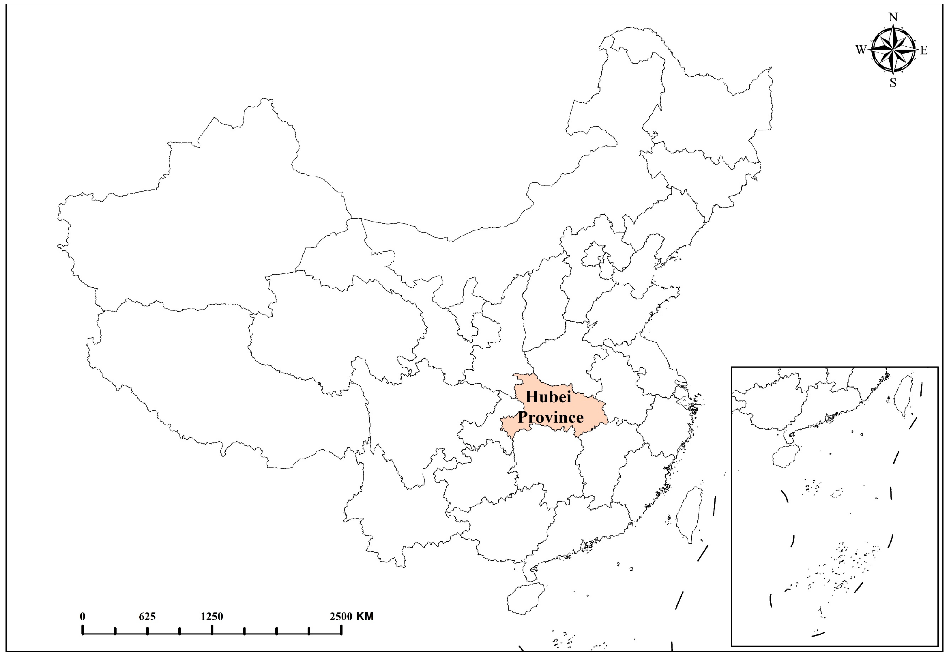
2.2. Study Area
2.3. Data Analysis Methods
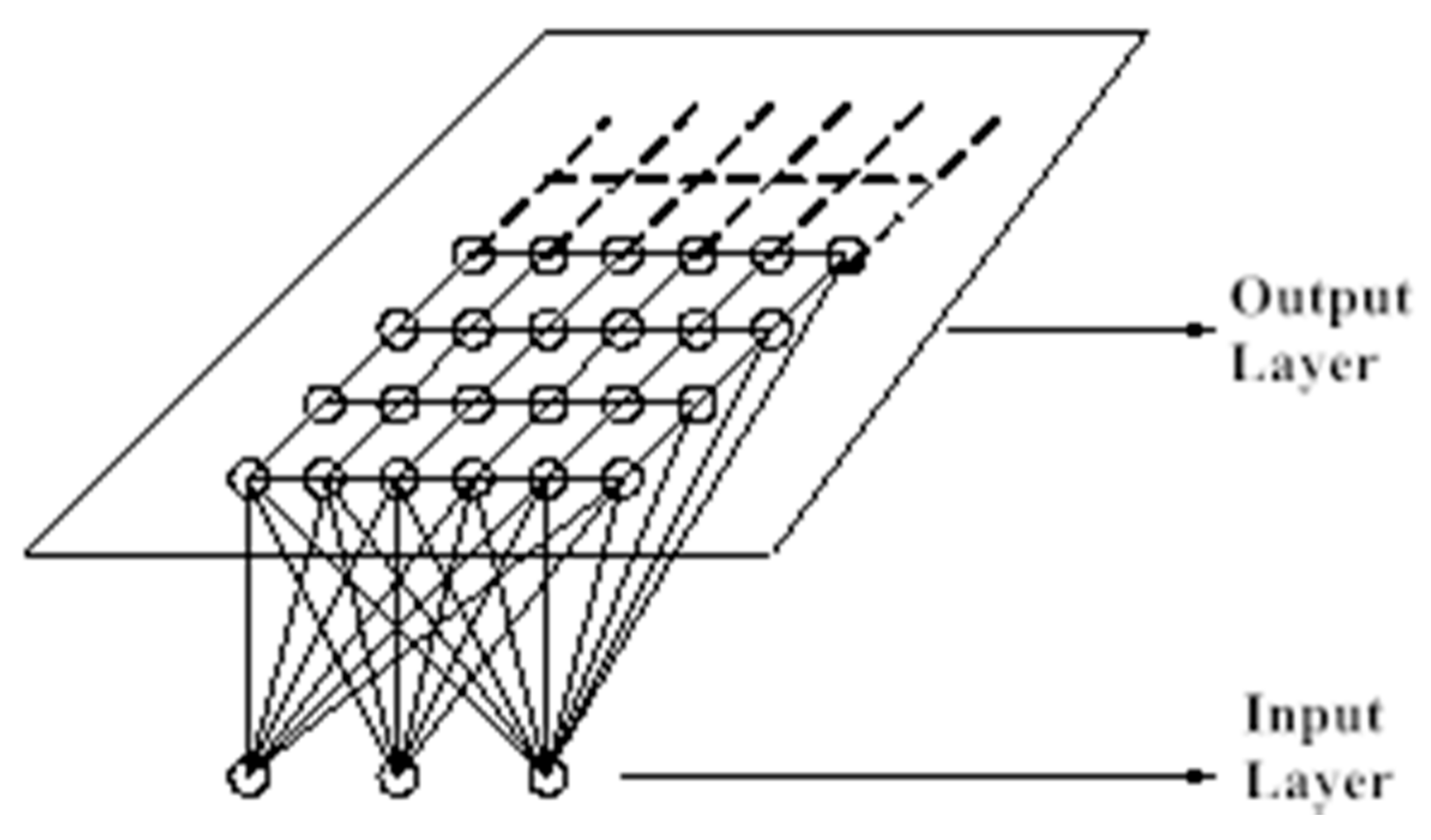
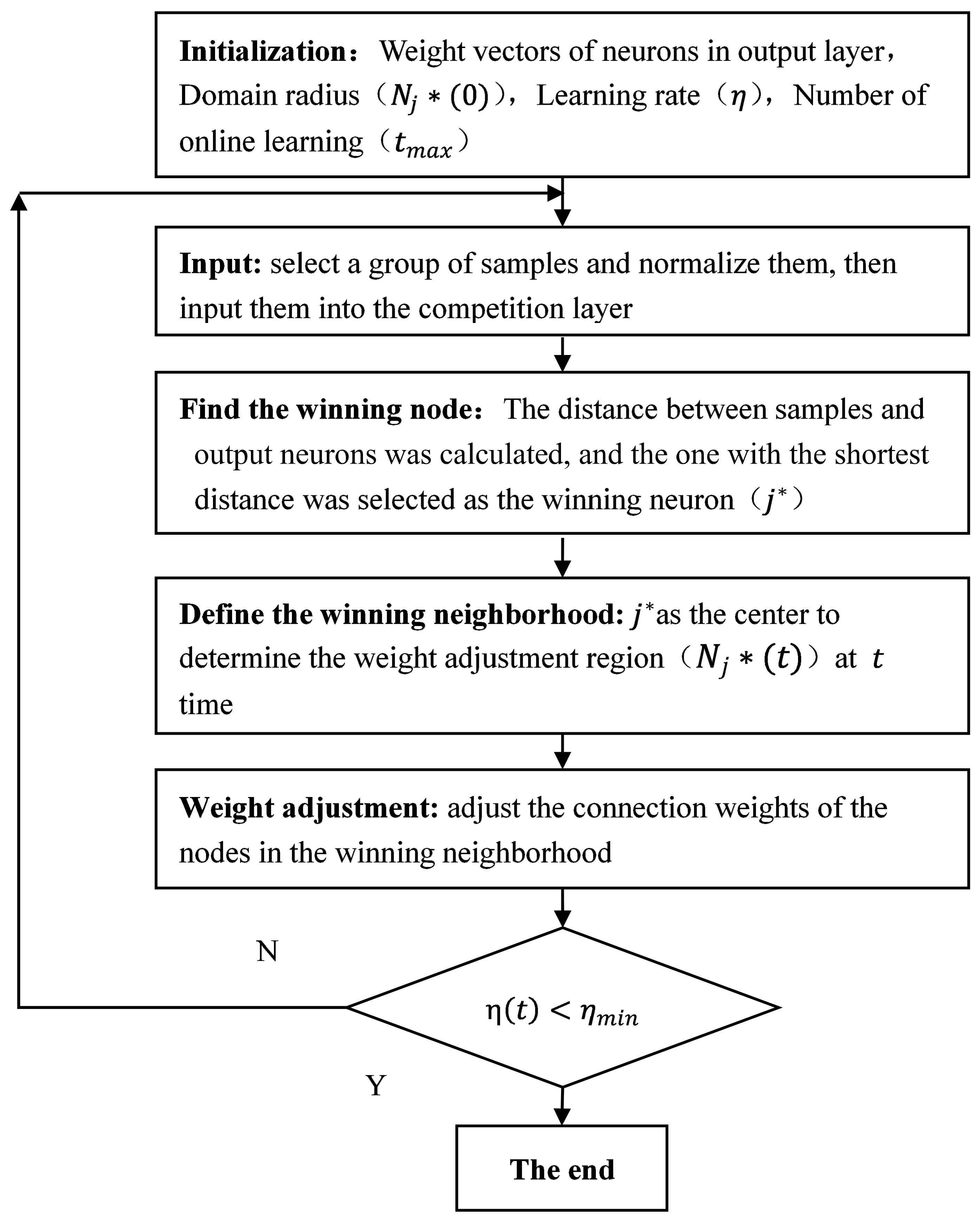
2.3.1. Self-Organizing Feature Map
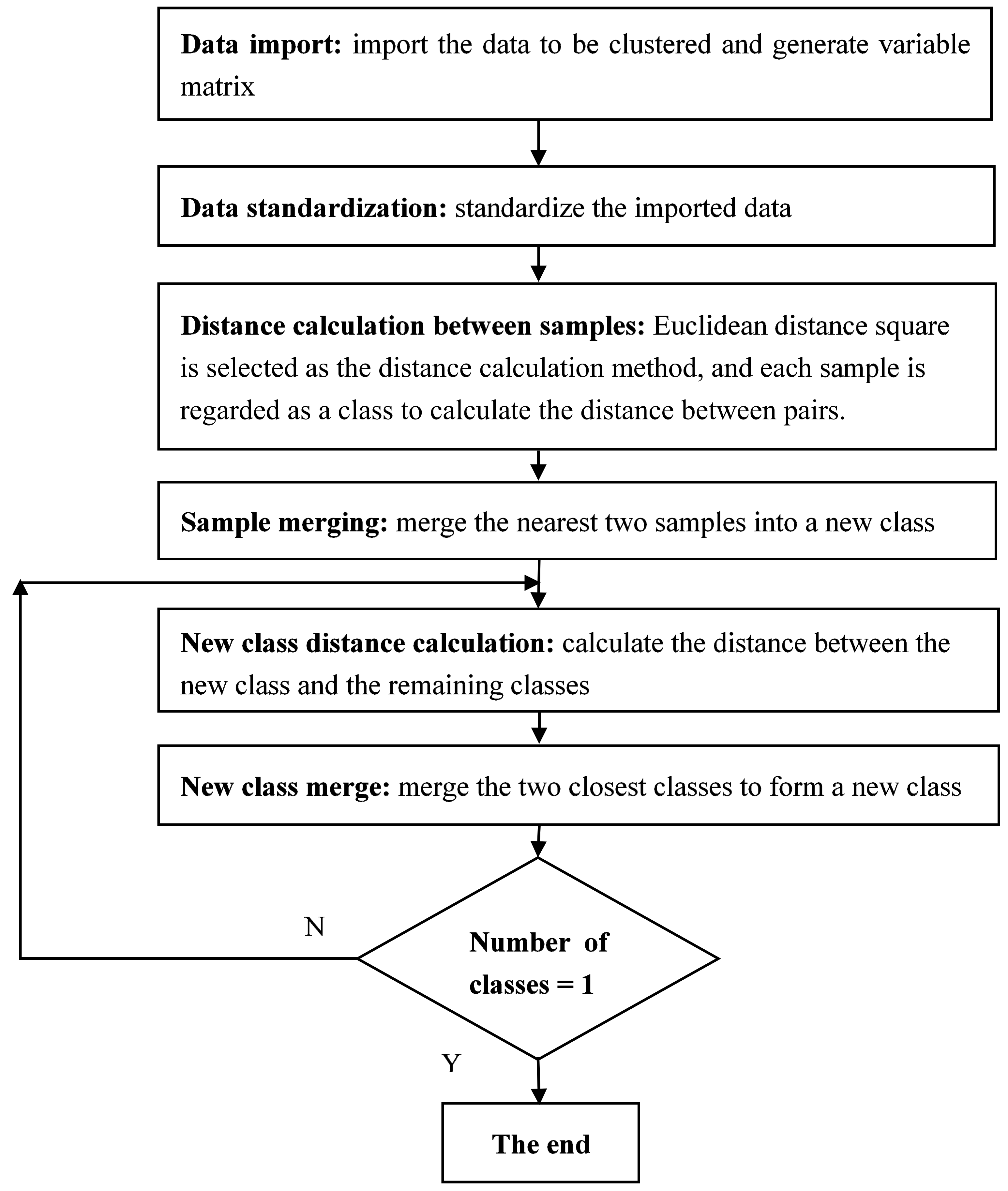
2.3.2. Hierarchical Clustering
2.4. Zoning Units and Indicator System
3. Results
3.1. Land Consolidation Zoning Based on SOM
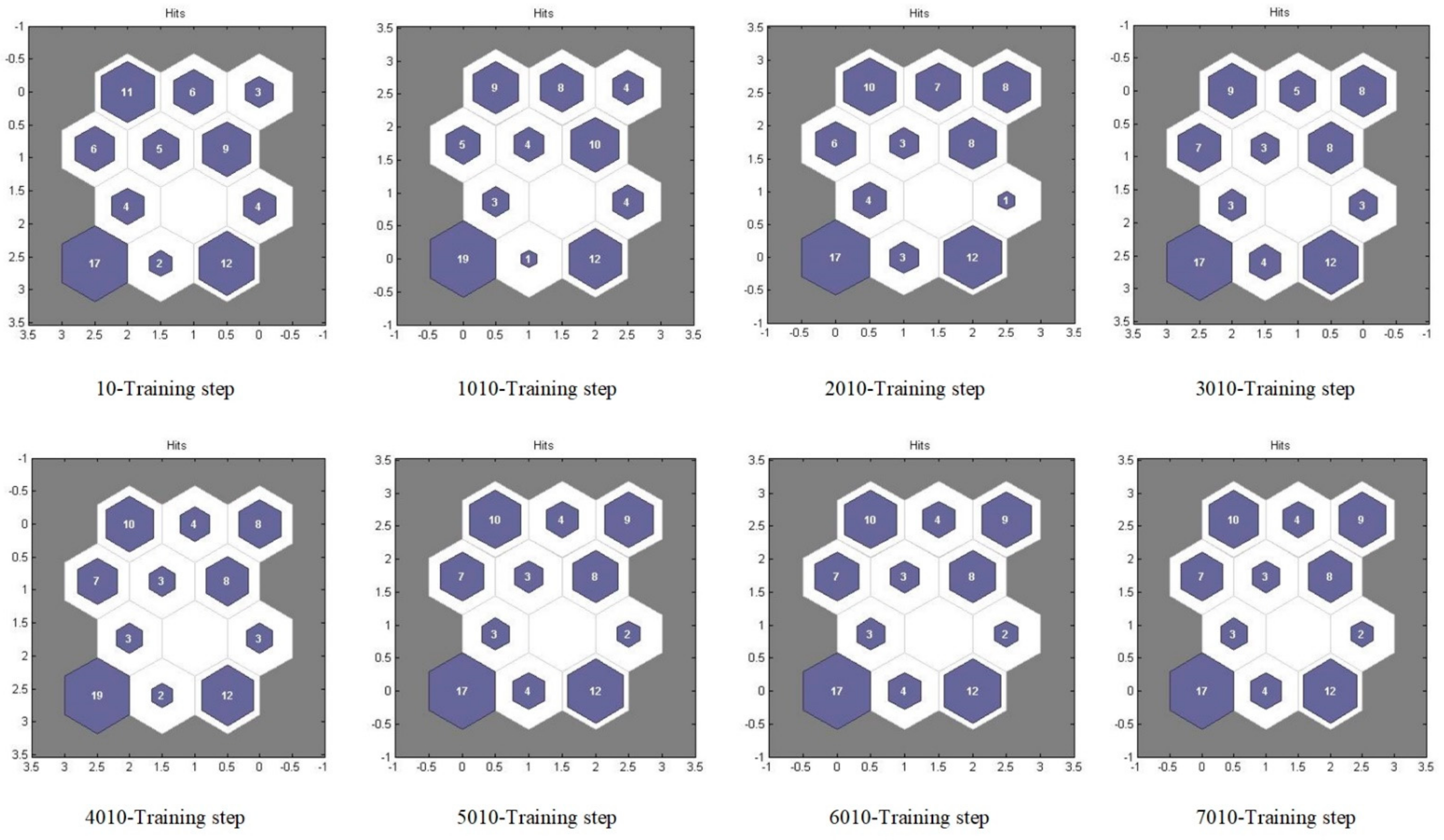
3.1.1. Establishment of SOM Classification Network Model
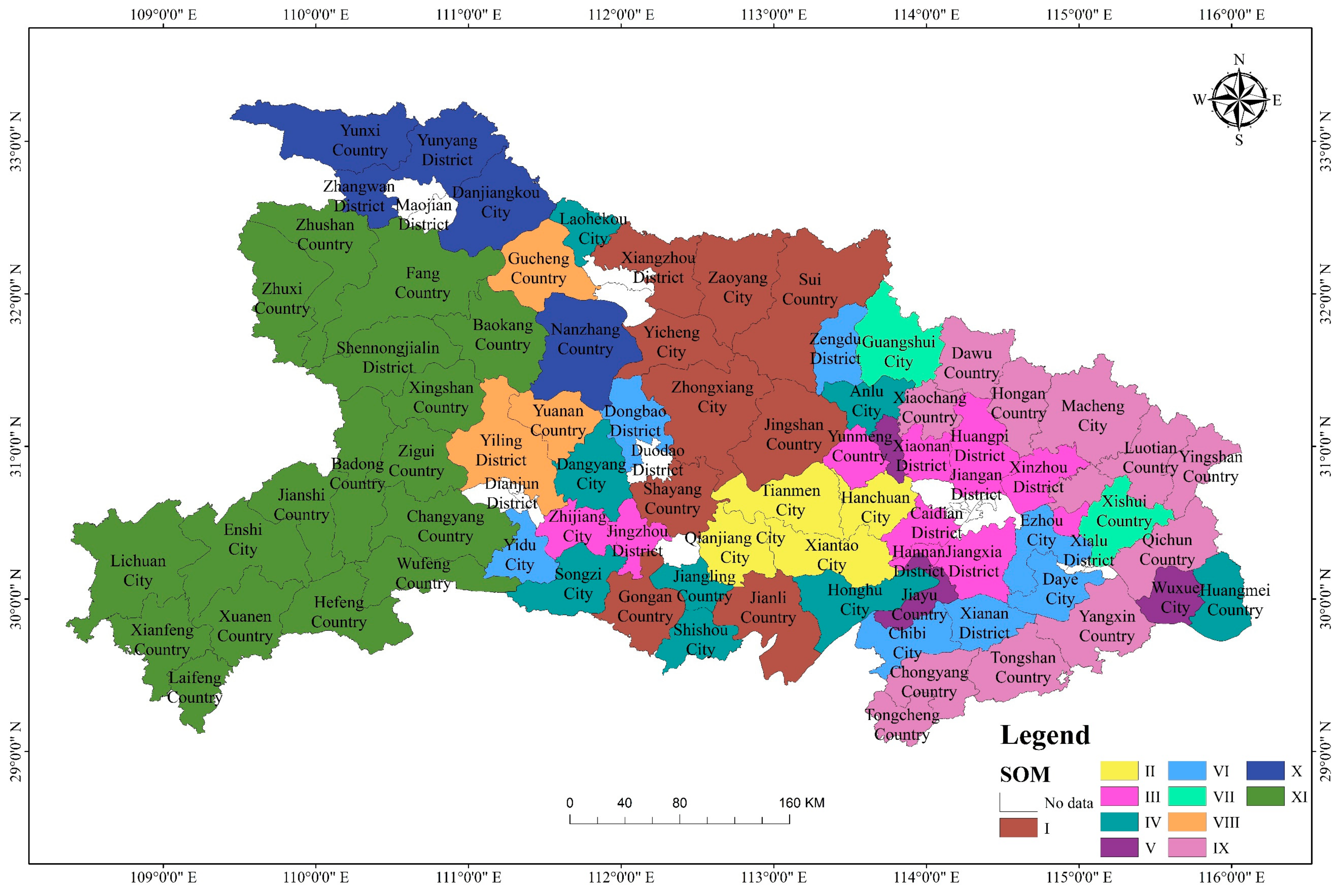
3.1.2. Clustering Results Based on SOM
3.2. Land Consolidation Zoning Based on Hierarchical Clustering
3.3. Coupling Analysis of the Two Clustering Results
3.4. Land Consolidation Zoning Scheme for Hubei Province
4. Discussions
5. Conclusions
- (1)
- Based on the consideration of natural resources, economic development, social indicators, and the ecological environment, and combined with the strategic positioning and policy guidance of land improvement in Hubei province, the proposed evaluation system of land consolidation zoning indicators is both comprehensive and scientific.
- (2)
- SOM clustering was first applied for land consolidation zoning in Hubei province, and 11 categories were determined. SOMs are self-learning, self-adapting systems with a degree of fault-tolerance. Therefore, they improve the rationality, objectivity, and repeatability of the resulting categories, and ensure the objectivity and reliability of the results.
- (3)
- Hierarchical clustering was also applied for land consolidation zoning in Hubei province, determining a total of 12 categories. These results were reasonable, and were in line with the real situation of Hubei province.
- (4)
- Integrating the advantages of SOM neural network clustering with those of hierarchical clustering, seven category partitions for the land consolidation zoning scheme in Hubei province were determined. According to different zoning characteristics, this paper has described the corresponding key points for land consolidation, providing a reference for relevant departments to arrange land consolidation projects, a scientific basis for the preparation of land consolidation planning in Hubei province, and a foundation for further spatial studies.
Author Contributions
Funding
Institutional Review Board Statement
Informed Consent Statement
Data Availability Statement
Acknowledgments
Conflicts of Interest
References
- Li, Y.; Wu, W.; Liu, Y. Land consolidation for rural sustainability in China: Practical reflections and policy implications. Land Use Policy 2018, 74, 137–141. [Google Scholar] [CrossRef]
- Demetriou, D. The assessment of land valuation in land consolidation schemes: The need for a new land valuation framework. Land Use Policy 2016, 54, 487–498. [Google Scholar] [CrossRef]
- Len, P. An algorithm for selecting groups of factors for prioritization of land consolidation in rural areas. Comput. Electron. Agr. 2018, 144, 216–221. [Google Scholar] [CrossRef]
- Luo, W.; Timothy, D.J. An assessment of farmers’ satisfaction with land consolidation performance in China. Land Use Policy 2017, 61, 501–510. [Google Scholar] [CrossRef]
- Wang, J.; He, T.; Lin, Y. Changes in ecological, agricultural, and urban land space in 1984–2012 in China: Land policies and regional social-economical drivers. Habitat Int. 2018, 71, 1–13. [Google Scholar] [CrossRef]
- Jiang, G.; Zhang, R.; Ma, W.; Zhou, D.; Wang, X.; He, X. Cultivated land productivity potential improvement in land consolidation schemes in Shenyang, China: Assessment and policy implications. Land Use Policy 2017, 68, 80–88. [Google Scholar] [CrossRef]
- Lin, K. Determining Key Ecological Indicators for Urban Land Consolidation. Int. J. Strateg. Prop. Manage. 2010, 14, 89–103. [Google Scholar] [CrossRef]
- Podhrázská, J.; Vaishar, A.; Toman, F.; Knotek, J.; Ševelová, M.; Stonawská, K.; Vasylchenko, A.; Karásek, P. Evaluation of Land Consolidation Process by Rural Stakeholders. Eur. Countrys. 2015, 7, 144–155. [Google Scholar] [CrossRef]
- Stańczuk-Gałwiaczek, M.; Sobolewska-Mikulska, K.; Ritzema, H.; van Loon-Steensma, J.M. Integration of water management and land consolidation in rural areas to adapt to climate change: Experiences from Poland and the Netherlands. Land Use Policy 2018, 77, 498–511. [Google Scholar] [CrossRef]
- Mansberger, R.; Seher, W. Land Administration and Land Consolidation as Part of Austrian Land Management. EU Agrar. Law 2017, 6, 68–76. [Google Scholar] [CrossRef][Green Version]
- Kupidura, A.; Łuczewski, M.; Home, R.; Kupidura, P. Public perceptions of rural landscapes in land consolidation procedures in Poland. Land Use Policy 2014, 39, 313–319. [Google Scholar] [CrossRef]
- Janus, J.; Taszakowski, J. Spatial differentiation of indicators presenting selected barriers in the productivity of agricultural areas: A regional approach to setting land consolidation priorities. Ecol. Indic. 2018, 93, 718–729. [Google Scholar] [CrossRef]
- Yan, J.; Xia, F.; Bao, H.X.H. Strategic planning framework for land consolidation in China: A top-level design based on SWOT analysis. Habitat Int. 2015, 48, 46–54. [Google Scholar] [CrossRef]
- Mwathunga, E.; Donaldson, R. Urban land contestations, challenges and planning strategies in Malawi’s main urban centres. Land Use Policy 2018, 77, 1–8. [Google Scholar] [CrossRef]
- Long, H. Land consolidation: An indispensable way of spatial restructuring in rural China. J. Geogr. Sci. 2014, 24, 211–225. [Google Scholar] [CrossRef]
- Bangbang, Z.; Wenhao, N.; Xuyang, Z.; Xiangbin, K.; Wenju, Y.; Haibin, C. Farmer-dominated pattern land consolidation to solve arable land fragmentation and its effectiveness evaluation in Guangxi. Trans. Chin. Soc. Agric. Eng. 2019, 35, 265–274. [Google Scholar]
- Mazzocchi, C.; Sali, G.; Corsi, S. Land use conversion in metropolitan areas and the permanence of agriculture: Sensitivity Index of Agricultural Land (SIAL), a tool for territorial analysis. Land Use Policy 2013, 35, 155–162. [Google Scholar] [CrossRef]
- Cay, T.; Iscan, F. Fuzzy expert system for land reallocation in land consolidation. Expert. Syst. Appl. 2011, 38, 11055–11071. [Google Scholar] [CrossRef]
- Xuejiao, L.; Wu, X.; Sucui, L.; Qiyuan, W.; Chunmeng, Z.; Miaomiao, Z. Land reclamation zoning of Chaohu Lake Basin based on GIS and grey constellation clustering. Trans. Chin. Soc. Agric. Eng. 2018, 34, 253–262. [Google Scholar]
- Yaslioglu, E.; Akkaya Aslan, S.T.; Kirmikil, M.; Gundogdu, K.S.; Arici, I. Changes in Farm Management and Agricultural Activities and Their Effect on Farmers’ Satisfaction from Land Consolidation: The Case of Bursa–Karacabey, Turkey. Eur. Plan. Stud. 2009, 17, 327–340. [Google Scholar] [CrossRef]
- Yu, G.; Feng, J.; Che, Y.; Lin, X.; Hu, L.; Yang, S. The identification and assessment of ecological risks for land consolidation based on the anticipation of ecosystem stabilization: A case study in Hubei Province, China. Land Use Policy 2010, 27, 293–303. [Google Scholar] [CrossRef]
- Xiao, P.; Zhou, Y.; Li, X.; Xu, J.; Zhao, C. Assessment of Heavy Metals in Agricultural Land: A Literature Review Based on Bibliometric Analysis. Sustainability 2021, 13, 4559. [Google Scholar] [CrossRef]
- Zhao, C.; Zhou, Y.; Jiang, J.; Xiao, P.; Wu, H. Spatial characteristics of cultivated land quality accounting for ecological environmental condition: A case study in hilly area of northern Hubei province, China. Sci. Total. Environ. 2021, 774, 145765. [Google Scholar] [CrossRef]
- Yan, J.; Shen, Y.; Xia, F. Differentiated Optimization of Sustainable Land Use in Metropolitan Areas: A Demarcation of Functional Units for Land Consolidation. Sustainability 2017, 9, 1356. [Google Scholar] [CrossRef]
- Janus, J.; Ertunç, E. The impact of differences in land fragmentation parameters on the planning, implementation, and evaluation of land consolidation projects. Case studies of Turkey and Poland. Comput. Electron. Agr. 2020, 179, 105813. [Google Scholar] [CrossRef]
- Wang, Y.; Li, Y. Promotion of degraded land consolidation to rural poverty alleviation in the agro-pastoral transition zone of northern China. Land Use Policy 2019, 88, 104114. [Google Scholar] [CrossRef]
- Sulonen, K.; Kotilainen, S. Lessor’s Status in Land Consolidation in Europe—Reports from Cyprus, Finland, France, Germany, the Netherlands, Latvia and Estonia. Balt. J. Real Estate Econ. Constr. Manage. 2015, 3, 56–71. [Google Scholar] [CrossRef]
- Zhao, C.; Zhou, Y.; Li, X.; Xiao, P.; Jiang, J. Assessment of Cultivated Land Productivity and Its Spatial Differentiation in Dongting Lake Region: A Case Study of Yuanjiang City, Hunan Province. Sustainability 2018, 10, 3616. [Google Scholar] [CrossRef]
- Chartin, C.; Evrard, O.; Salvador-Blanes, S.; Hinschberger, F.; Van Oost, K.; Lefèvre, I.; Daroussin, J.; Macaire, J. Quantifying and modelling the impact of land consolidation and field borders on soil redistribution in agricultural landscapes (1954–2009). Catena 2013, 110, 184–195. [Google Scholar] [CrossRef]
- Oy, L.; Vesanto, J.; Himberg, J.; Esa, A.; Parhankangas, J. SOM Toolbox for Matlab 5; Helsinki University of Technology: Espoo, Finland, 2000; p. 2. [Google Scholar]
- Teuvo, K. Self-Organizing Maps; Springer: Berlin/Heidelberg, Germany; New York, NY, USA, 2001; pp. 585–622. [Google Scholar]
- Liu, Y.; Weisberg, R.H. A Review of Self-Organizing Map Applications in Meteorology and Oceanography; IntechOpen: London, UK, 2011. [Google Scholar]
- Tsakovski, S.; Astel, A.; Simeonov, V. Assessment of the water quality of a river catchment by chemometric expertise. J. Chemometr. 2010, 24, 694–702. [Google Scholar] [CrossRef]
- Wang, B.; Li, H.; Sun, D. Social-Ecological Patterns of Soil Heavy Metals Based on a Self-Organizing Map (SOM): A Case Study in Beijing, China. Int. J. Environ. Res. Public Health 2014, 11, 3618–3638. [Google Scholar] [CrossRef] [PubMed]
- Stankiewicz, A.; Kosiba, P. Advances in ecological modelling of soil properties by self-organizing feature maps of natural environment of Lower Silesia (Poland). Acta Soc. Bot. Pol. 2009, 78, 167. [Google Scholar] [CrossRef][Green Version]
- Merdun, H. Self-organizing map artificial neural network application in multidimensional soil data analysis. Neural Comput. Appl. 2011, 20, 1295–1303. [Google Scholar] [CrossRef]
- Petrov, N.; Georgieva, A.; Jordanov, I. Self-organizing maps for texture classification. Neural Comput. Appl. 2013, 22, 1499–1508. [Google Scholar] [CrossRef][Green Version]
- Rivera, D.; Sandoval, M.; Godoy, A. Exploring soil databases: A self-organizing map approach. Soil. Use Manage. 2015, 31, 121–131. [Google Scholar] [CrossRef]
- Jiang, Y.; Hou, L.; Shi, T.; Ning, Y. Spatial Zoning Strategy of Urbanization Based on Urban Climate Co-Movement: A Case Study in Shanghai Mainland Area. Sustainability 2018, 10, 2706. [Google Scholar] [CrossRef]
- Yajie, H.; Huichun, Y.; Shiwen, Z.; Wenju, Y.; Yuanfang, H. Zoning of Arable Land Productivity Based on Self-organizing Map in China. Sci. Agric. Sin. 2015, 1136–1150. [Google Scholar]
- Yajie, Z.; Junling, Z.; Yang, Y.; Shenghua, L.; Li, J. Application of Hierarchical Clustering Analysis Method to Land Use Regionalization in Lianzhou. Sci. Technol. Manage. Land Resour. 2007, 24, 71–76. [Google Scholar]
- Tian, L.; Liu, Y.Z.; Yi, Z.X.; Yan, L.; Gui, Z.W.; Hu, L. Comparative Research on the Impact of Correlation between Clustering Factors on Land Use Zoning: A Case Study of Linxiang, China. Appl. Mech. Mater. 2013, 295–298, 2481–2485. [Google Scholar] [CrossRef]
- Jiqiang, N.; Jinru, X.; Feng, X.; Zhifeng, C. Design and Implementation of spatial clustering system for land use zoning. Sci. Surv. Mapp. 2013, 38, 178–180. [Google Scholar]
- Sidorova, V.S. Hierarchical cluster algorithm for remote sensing data of earth. Pattern Recognit. Image Anal. 2012, 22, 373–379. [Google Scholar] [CrossRef]
- Yoon, H. Interrelationships between retail clusters in different hierarchies, land value and property development: A panel VAR approach. Land Use Policy 2018, 78, 245–257. [Google Scholar] [CrossRef]
- Wenheng, W.; Zewei, X.; Xinjun, Y. Quantitative research of spatial development differentiation in Xi’an from the perspective of urban functional zoning. Geogr. Res. Aust. 2012, 31, 2173–2184. [Google Scholar]
- Wang, K.; Ou, M.; Wolde, Z. Regional Differences in Ecological Compensation for Cultivated Land Protection: An Analysis of Chengdu, Sichuan Province, China. Int. J. Environ. Res. Public Health 2020, 17, 8242. [Google Scholar] [CrossRef]
- Mihara, M. Effects of Agricultural Land Consolidation on Erosion Processes in Semi-Mountainous Paddy Fields of Japan. J. Agric. Eng. Res. 1996, 64, 237–247. [Google Scholar] [CrossRef]
- Sonnenberg, J. The European dimensions and land management policy issues (land readjustment and land consolidation as tools for development). Land Manage. Process. Transit. 1996, 7, 2–3. [Google Scholar]
- Jun, W.; Zheng, L.; Zhongke, B.; Zhengshan, J.; Guoru, W. Progress and prospect of ecological environment impact of land consolidation. Trans. Chin. Soc. Agric. Eng. 2011, S1, 340–345. [Google Scholar]
- Thomas, J. Attempt on Systematization of Land Consolidation Approaches in Europe. ZFV Z. Fur Geodasie Geoinf. Und Landmanagement 2006, 161, 156–161. [Google Scholar]
- Sklenicka, P. Applying evaluation criteria for the land consolidation effect to three contrasting study areas in the Czech Republic. Land Use Policy 2006, 23, 502–510. [Google Scholar] [CrossRef]


| Category of Indicator | Meta Indicator | Explanation or Calculation of Indicator |
|---|---|---|
| Natural ecological condition | Geographic and geomorphic conditions | According to the topography of Hubei province, this is divided into four types: plain, downland, hilly, and mountainous plateau. |
| Forest coverage (%) | Percentage of forested area in a country or region whose canopy density is above 0.2. | |
| Ecological importance rating | Degree of ecological fragility and the priority of ecological protection, which can be divided into national key ecological function areas, national agricultural producing areas, key ecological function areas of Hubei province, and other key ecological function areas of Hubei province, provincial key development areas, and national key development areas. * | |
| Geological hazard rating | Degree of vulnerability to geological disasters, including geological disasters that may easily occur, geological hazards that may occur, geological disasters that are less likely to occur, and geological disasters that are generally unlikely to occur. ** | |
| Socioeconomic condition | GDP per capita (CNY) | Gross domestic product per capita. |
| Disposable income of rural residents per capita (CNY) | Income received by each rural household after initial distribution and redistribution. | |
| Agricultural machinery total power per acre (kw/ha) | Agricultural machinery total power per acre (kw/ha) = Total power of agricultural machinery (kw) divided by the area planted with crops (ha). | |
| Urbanization rate (%) | Urbanization rate (%) = urban population divided by the total population. | |
| Effective irrigation rate (%) | Effective irrigation rate (%) = effective irrigation area (ha) divided by the total cultivated area (ha). | |
| Key poverty-stricken county | Yes or no based on the poverty-stricken counties in the 13th five-year plan period of Hubei province. *** | |
| Land-use condition | Land reclamation rate (%) | Land reclamation rate (%) = total area of cultivated land (ha) divided by the total area of land (ha). |
| Land use rate (%) | Land use rate (%) = used land area (ha) divided by the total land area (ha). | |
| Yield of crop per unit area (kg/ha) | Yield of crop per unit area (kg/ha) = total crop yield (kg) divided by the area planted with crops (ha). | |
| Cultivated area per capita (ha/person) | Cultivated area per capita (ha/person) = total area of cultivated land (ha) divided by the total population. | |
| Land consolidation potential | Agricultural land potential grade | This indicator can reflect the area and quality of cultivated land that can be renovated in the region. **** |
| Rural construction potential grade | It refers to the grade of the area of effective cultivated land and other land that can be increased through the transformation of existing rural residential areas and the relocation and consolidation of villages. The larger the area is, the higher the grade is. **** | |
| Development potential grade of unused land | It refers to the area of unused land suitable for cultivated land and other agricultural land under certain technical and ecological environment conditions. The larger the area, the higher the grade. **** | |
| Reclamation potential grade of abandoned land | It refers to the area of arable land and other agricultural land that can be increased after the remediation measures are taken for the damaged and abandoned land in the process of production and construction. The larger the area, the higher the grade. **** |
| Categories | Including Units |
|---|---|
| I | Xiangzhou District, Zhaoyang City, Yicheng City, Jingshan County, Shayang County, Zhongxiang City, Gongan County, Jianli County, Sui County |
| II | Hanchuan City, Xiantao City, Qianjiang City, Tianmen City |
| III | Caidian District, Jiangxia District, Huangpi District, Xinzhou District, Hannan District, Zhijiang City, Xiaonan District, Yingcheng City, Jingzhou District, Huangzhou District |
| IV | Dangyang City, Laohekou City, Anlu City, Jiangling County, Shishou City, Honghu City, Songzi City, Huangmei County |
| V | Yunmeng County, Wuxue City, Jiayu County |
| VI | Daye City, Yidu City, Ezhou City, Dongbao District, Xianan District, Chibi City, Zengdu District |
| VII | Xishui County, Guangshui City |
| VIII | Yiling District, Yuanan County, Gucheng County |
| IX | Yangxin County, Xiaochang County, Dawu County, Tuanfeng County, Hongan County, Luotian County, Yingshan County, Qichun County, Macheng City, Tongcheng County, Chongyang County, Tongshan County |
| X | Yunyang District, Yunxi County, Danjiangkou City, Nanzhang County |
| XI | Zhushan County, Zhuxi County, Fang County, Xingshan County, Zigui County, Changyang County, Wufeng County, Baokang County, Enshi City, Lichuan City, Jianshi County, Badong County, Xuanen County, Xianfeng County, Laifeng County, Hefeng County, Shennongjia Forestry District |
| Categories | Including Units |
|---|---|
| I | Dangyang City, Laohekou City, Shayang County, Yunmeng County, Anlu City, Jiangling County, Gongan County, Jianli County, Shishou City, Honghu City, Songzi City, Xishui County, Huangmei County, Wuxue City, Jiayu County |
| II | Zaoyang City, Yicheng City, Jingshan County, Zhongxiang City, Sui County, Guangshui City |
| III | Dongan District, Xianan District, Chibi City, Zengdu District |
| IV | Caidian District, Jiangxia District, Huangpi District, Xinzhou District, Hannan District, Zhijiang City, Ezhou City, Xiaonan District, Yingcheng City, Hanchuan City, Jingzhou District, Xiantao City, Qianjiang City, Tianmen City |
| V | Xiangzhou District |
| VI | YiLing District, Yidu City |
| VII | Daye City |
| VIII | Huangzhou District |
| IX | Yuanan County, Nanzhang County, Gucheng County |
| X | Xiaochang County, Dawu County, Tuanfeng County, Hongan County, Luotian County, Yingshan County, Qichun County, Macheng City, Tongcheng County, Chongyang County, Tongshan County |
| XI | Yunyang District, Yunxi County, Zhushan County, Zhuxi County, Fang County, Danjiangkou City, Xingshan County, Zigui County, Changyang County, Wufeng County, Baokang County, Enshi City, Lichuan City, Jianshi County, Badong County, Xuanen County, Xianfeng County, Laifeng County, Hefeng County, Shennongjia Forestry District |
| XII | Yangxin County |
| Integrated Category Partitions | Including Units in Integrated Category Partitions | Difference between Two Clustering Method | |
|---|---|---|---|
| Including Units (Old Category Based on SOM Cluster Method) | Including Units (Old Category Based on Hierarchical Cluster Method) | ||
| I | Caidian District, Jiangxia District, Huangpi District, Xinzhou District, Hannan District, Zhijiang City, Xiaonan District, Yingcheng City, Hanchuan City, Jingzhou District, Xiantao City, Qianjiang City, Tianmen City | Huangzhou District (III) | Ezhou City (IV) |
| II | Zaoyang City, Yicheng City, Jingshan County, Zhongxiang City, Sui County | Xiangzhou District (I) | Guangshui City (II) |
| III | Dangyang City, Laohekou City, Anlu City, Jiangling County, Shishou City, Honghu City, Songzi City, Huangmei County, Yunmeng County, Wuxue City, Jiayu County | - (IV/V) | Gongan County, Jianli County, Shayang County, Xishui County (I) |
| IV | Dongbao District, Xianan District, Chibi City, Zengdu District | Dazhi City, Yidu City (VI) | - (III) |
| V | Xiaochang County, Dawu County, Tuanfeng County, Hongan County, Luotian County, Yingshan County, Qichun County, Macheng City, Tongcheng County, Chongyang County, Tongshan County | Yangxin County (IX) | - (X) |
| VI | Yiling District, Yuanan County, Gucheng County | - (VIII) | Nanzhang County, Yidu City (VI/IX) |
| VII | Zhushan County, Zhuxi County, Fang County, Xingshan County, Zigui County, Changyang County, Wufeng County, Baokang County, Enshi City, Lichuan City, Jianshi County, Badong County, Xuanen County, Xianfeng County, Laifeng County, Hefeng County, Shennongjia Forestry District | - (XI) | Yunyang District, Yunxi District, Danjiangkou City (XI) |
| Unclassified | Guangshui City, Xishui County | ||
| Integrated Categories | Including Units |
|---|---|
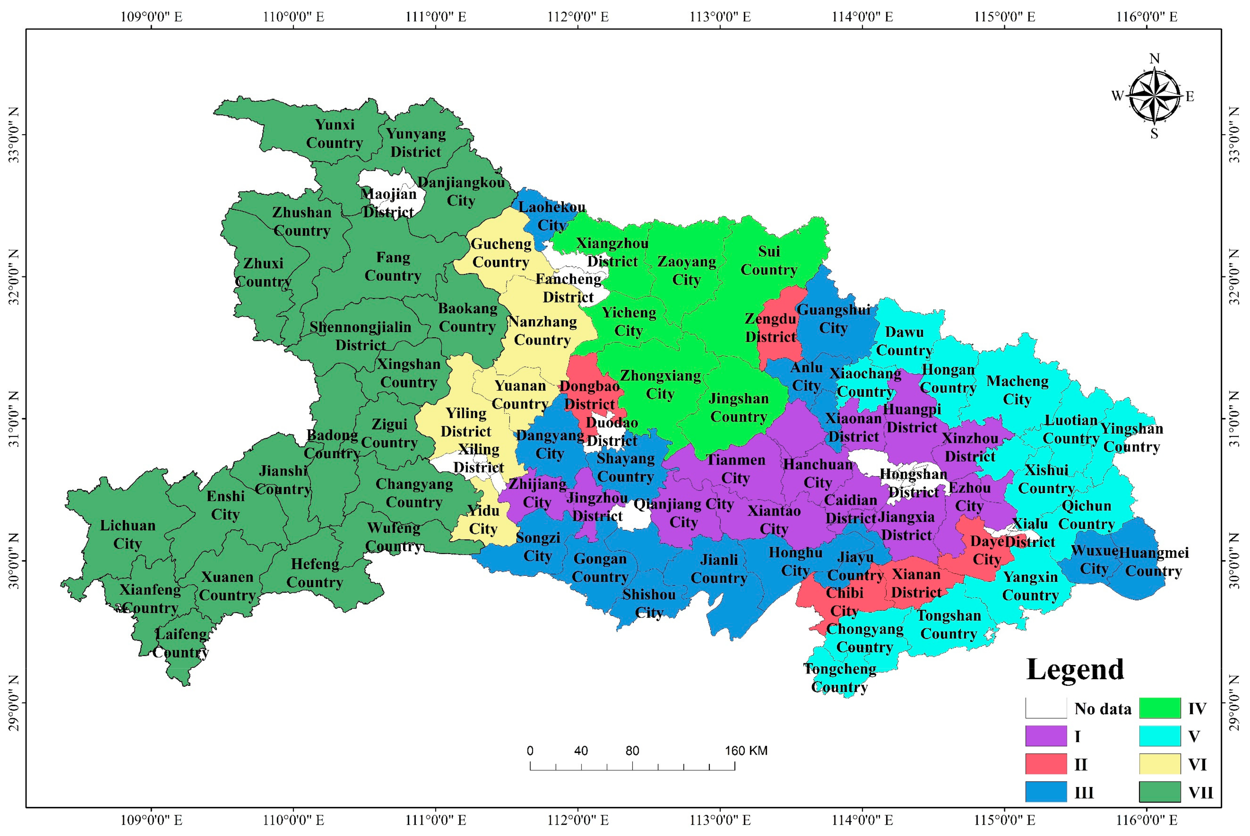
| I | Caidian District, Jiangxia District, Huangpi District, Xinzhou District, Hannan District, Zhijiang City, Xiaonan District, Yingcheng City, Hanchuan City, Jiangzhou District, Huangzhou District, Ezhou City, Xiantao City, Qianjiang City, Tianmen City |
| II | Zaoyang City, Yicheng City, Jiangshan County, Zhongxiang City, Sui County, Xiangzhou District |
| III | Dangyang City, Laohekou City, Anlu City, Jiangling County, Shishou City, Honghu City, Songzi City, Huangmei County, Yunmeng County, Wuxue City, Jiayu County, Gongan County, Jianli County, Shayang County, Guangshui City |
| IV | Dongbao District, Xianan District, Chibi City, Zengdu District, Dazhi City |
| V | Xiaochang County, Dawu County, Tuanfeng County, Hongan County, Luotian County, Yingshan County, Qichun County, Macheng City, Tongcheng County, Chongyang County, Tongshan County, Yangxin County, Xishui County |
| VI | Yiling District, Yuanan District, Gucheng County, Nanzhang County, Yidu City |
| VII | Zhushan County, Zhuxi County, Fang County, Xingshan County, Zigui County, Changyang County, Wufeng County, Baokang County, Enshi City, Lichuan City, Jianshi County, Badong County, Xuanen County, Xianfeng County, Laifeng County, Hefeng County, Shennongjia Forestry District, Yunyang District, Yunxi County, Danjiangkou City |
Publisher’s Note: MDPI stays neutral with regard to jurisdictional claims in published maps and institutional affiliations. |
© 2021 by the authors. Licensee MDPI, Basel, Switzerland. This article is an open access article distributed under the terms and conditions of the Creative Commons Attribution (CC BY) license (https://creativecommons.org/licenses/by/4.0/).
Share and Cite
Xiao, P.; Zhao, C.; Zhou, Y.; Feng, H.; Li, X.; Jiang, J. Study on Land Consolidation Zoning in Hubei Province Based on the Coupling of Neural Network and Cluster Analysis. Land 2021, 10, 756. https://doi.org/10.3390/land10070756
Xiao P, Zhao C, Zhou Y, Feng H, Li X, Jiang J. Study on Land Consolidation Zoning in Hubei Province Based on the Coupling of Neural Network and Cluster Analysis. Land. 2021; 10(7):756. https://doi.org/10.3390/land10070756
Chicago/Turabian StyleXiao, Pengnan, Chong Zhao, Yong Zhou, Haoyu Feng, Xigui Li, and Jinhui Jiang. 2021. "Study on Land Consolidation Zoning in Hubei Province Based on the Coupling of Neural Network and Cluster Analysis" Land 10, no. 7: 756. https://doi.org/10.3390/land10070756
APA StyleXiao, P., Zhao, C., Zhou, Y., Feng, H., Li, X., & Jiang, J. (2021). Study on Land Consolidation Zoning in Hubei Province Based on the Coupling of Neural Network and Cluster Analysis. Land, 10(7), 756. https://doi.org/10.3390/land10070756