Article

Land-Use Transition of Tourist Villages in the Metropolitan Suburbs and Its Driving Forces: A Case Study of She Village in Nanjing City, China

1
School of Geography, Nanjing Normal University, Nanjing 210023, China
2
College of Rural Vitalization, Nanjing Normal University, Nanjing 210023, China
3
Jiangsu Center for Collaborative Innovation in Geographical Information Resource Development and Application, Nanjing 210023, China
*
Author to whom correspondence should be addressed.
Land 2021, 10(2), 168; https://doi.org/10.3390/land10020168
Submission received: 19 January 2021 / Revised: 30 January 2021 / Accepted: 3 February 2021 / Published: 6 February 2021
(This article belongs to the Special Issue Land Use Transitions under Rapid Urbanization)

Abstract

:
In the context of the transition from “Native-rural China” to “Urban-rural China”, suburban villages have undergone rapid reconstruction of format, industry, and function. Aiming to reveal the evolution characteristics and driving forces, this study selected She Village, located in suburban areas of Nanjing, to analyze the changes of both dominant and recessive morphology of land use by employing participatory rural appraisal, remote sensing, and geographic information systems. The results showed that She Village witnessed three stages, including industrial development, ecological restoration, and service industry development, from 1980 to 2018, with more diversified management modes, multifunctional land use, and intensified land fragmentation. The drivers included natural resources, population growth, policy of Grain for Green, urban market demand, etc., the intensity of which showed trends of “increase–increase–increase”, “increase–decrease–decrease”, “periodically intermittent”, and “increase–decrease–increase” in turn. The tourist villages undergo three stages of industrial development, agricultural development, and service industry development, with periodical characteristics driven by top-down policies, the endogenous force of the village, and the radiation and diffusion of the city. This research deepens the understanding of the development process of suburban villages and provides a reference for land policy making and planning in other similar villages.

1. Introduction

With industrialization, urbanization, informatization, and agricultural modernization, the once-solidified urban–rural dualistic structure is being deconstructed [1]. The production factors between rural and urban areas have turned into a two-way flow from a one-way flow, and China has been transferred from “Native-rural China” to “Urban-rural China” [2], in which the rural system has been characterized by rapid reconstruction of economic, social, and comprehensive dimensions [3]; heterogeneity [4]; consumerization and capitalization [5] of rural space; and multifunctionalization of agriculture and village [6], etc. After the introduction of the rural revitalization strategy, many topics have been put forward on rural transformation [7,8,9,10]. In research of rural transformation, land-use change, as a projection of social and economic development spatially, can directly show the stages and issues of rural transformation and development [11,12]. Today, land-use transition has become an important aspect to study rural transformation, thanks to deepened exploration in geography, land-use morphology, and other relevant disciplines. On one hand, the current theoretical research on land-use transition at a village scale largely focuses on the coupling relationship between land-use transition and rural transformation [13] and rural economy [14], on the relationship between land-use transition and rural revitalization [15] and rural spatial governance [16], and also on analysis framework of land-use transition in certain regions [17], etc. On the other hand, empirical research mainly includes the evolution and mechanism of spatial differentiation and reconstruction [3,18,19], the land-use change of typical villages [20,21,22], and transformation of land-use function [23,24,25]. However, despite great emphasis put on the dominant morphology of land use in the study of rural land-use transition, the current pool of research on recessive morphology is limited to the function of land use and ignores the roles played by other recessive factors that also contribute to rural transformation, such as the management modes and land ownership. In addition, the current research has only been committed to single land-use morphology, but produced hardly any research results in a deepened exploration of land-use transition when it comes to a dual perspective of dominant and recessive morphology. Therefore, an analysis with a dual perspective at the village scale can further contribute to the research on rural land-use transition.
Suburban villages, located in marginal areas of a city, where the urban and rural production factors are actively allocated, are affected by both the rural and urban systems [26]. Due to their characteristics of mixed population composition, diverse industrial structures, and large gradients of landscape space [27], these villages have emerged as the most active area of rural transformation and development. In the context of rapid agricultural modernization and industrialization, the types of land use are complex, and some suburban villages are facing challenges such as disorderly expansion of land use, ambiguous land ownership [12], and lagging improvement of function [19]. All these factors, to a certain extent, have hindered the transition and development of suburban villages. Nanjing is a typical megacity in eastern China, where the land-use morphology of some suburban villages has seen dramatic changes after the implementation of the Beautiful Countryside Construction policy. This paper focused on the spatial-temporal evolution of the dominant and recessive morphology of land-use transition in rural areas, and analyzed the driving forces of rural land-use transition. This paper, taking She Village in the suburbs of Jiangning, Nanjing City as an example, analyzed the changing course and driving forces of dominant and recessive morphology of land use of the village from 1980 to 2018, and explored the transformation mechanism of land use in a typical village, which revealed the law of land use in the process of suburban rural development. It is also conducive to deeper exploration of the land-use transition under the rural revitalization strategy, and at the same time, provides suggestions and references for the development of format and land policy making and planning in suburban villages.

2. Analysis of Land-Use Transition in Tourist Villages in the Suburbs

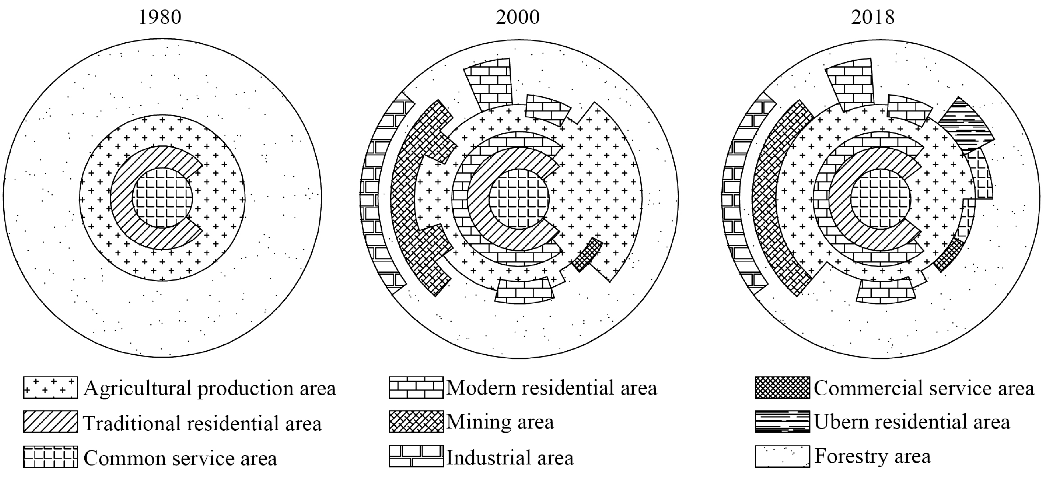
2.1. Division of Transformation Stages and Characteristics of Land-Use Morphology of Tourist Villages in the Suburbs

Land-use transition is a long-term event [28] that can be materialized through various channels. It has no clear boundary between the beginning and the end of the land-use transition. However, suburban tourist villages have seen notable variation characteristics at different rural development stages in land-use morphology, which are caused by rapid industrialization and urbanization. The division of stages involved in relevant studies is mainly based on leading industries, key events, moving T-test techniques, and the Mann–Kendall test [29]. Based on different leading industries in different stages, the development of suburban tourist villages can be divided into three stages: industrial development, agricultural development, and service industry development.
The stage of agricultural development mainly features the expansion of cultivated land, the slowed growth of residential land, and a relatively high proportion of unused land within the village. Land is collectively owned and collectively managed after transferring from petty-farmer management. At this stage, the suburban villages play the role of a production base of agricultural and sideline products for the entire city, as its land mainly undertakes the functions of residence and agricultural production. At the early stage of industrial development, land-use change is mainly manifested as rapid expansion of industrial land and the decrease of agricultural land. The change of agricultural land specifically features reduction of food crops, increase of orchards and economic forests, and the increasing commercialization of food products. With the slowdown in the growth rate of industrial land, the area of newly added industrial land has reached its limit. At the end of this stage, the area of industrial land no longer grows or even shows negative growth, usually accompanied with ecological restoration and environmental remediation. The investment of capital and labor in land decreases obviously, the enthusiasm for farming decreases gradually, and the land appears to have extensive utilization to a certain extent. Meanwhile, urban land appears after massive land expropriation, occupying agricultural land and other types of land. Land-use rights are transferred on a small-scale based on contracted management rights, with the coexistence of household operations and scale operations. At this stage, the village, as the city’s industrial development zone, commodity distribution center, and warehouse logistics center, undertakes the functions transferred from urban areas, including logistics and warehousing, science, education, culture, and health. The stage of the service industry development is mainly manifested in the rapid increase of commercial land, public service land, and ecological land such as forest land. The distribution of urban and rural land are interlaced, with more fragmented and intensive land and more appropriate internal layout of villages. The property rights of rural land are further differentiated, and household operation, collective operation, enterprise operation, and cooperative operation coexist. Ecological protection and commercial service functions become prominent functions of suburban villages at this stage.

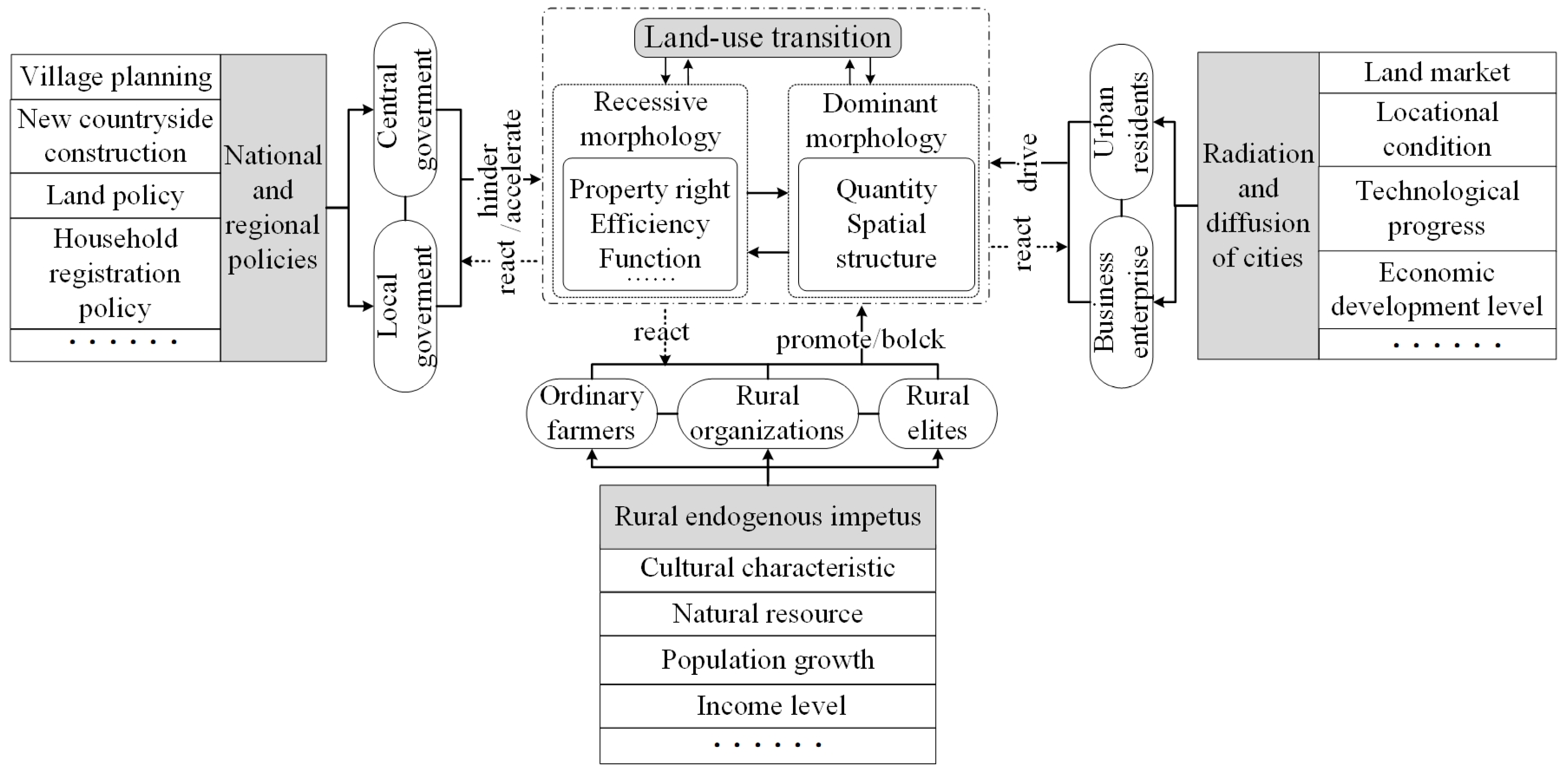
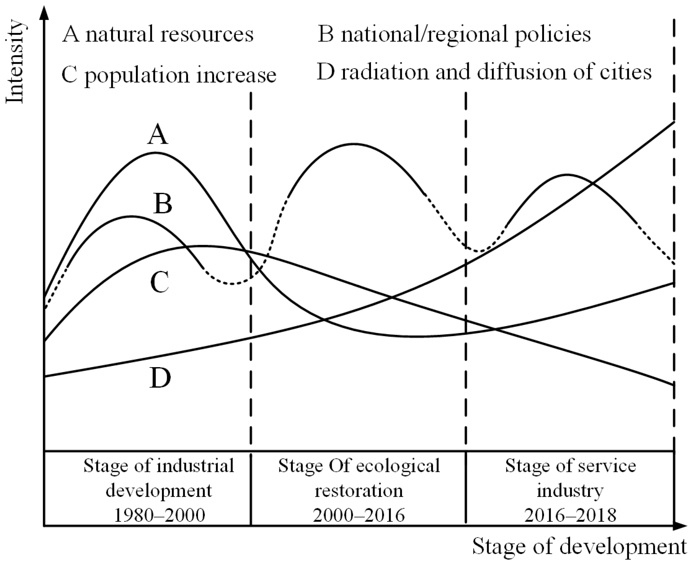
2.2. The Driving Forces of Land-Use Transition in Tourism Villages

Land-use transition always happens within the three-fold framework of natural systems, economic and social systems, and institutional systems [15]. Suburban villages are subject to the joint impact by both rural and urban–rural systems due to their special geographical location—on the margin of a city [30]. There are three major factors driving rural land-use transition: First, national and regional policies. By implementing various strategies at different levels including land policies, village planning, household registration policies, etc., governments can impose control on the direction and mode of land-use transition. However, it is hardly feasible to make any adjustment due to its comprehensiveness, thoroughness, high efficiency, and coerciveness [31]. Second, the rural endogenous power. With various factors, including natural resources, cultural characteristics, population growth, and income levels, such factors can indirectly affect the process and results of land-use transition through the behavioral decisions made by subjects of land use, which have a certain degree of fixity and uncontrollability. As a leading factor in rural land-use transition at a certain stage, this second driving force features notable characteristics in each stage in terms of intensity, scope, and duration. Third, the radiation and diffusion of cities. Consisting of the land market, economic development level, locational conditions, market demand, technological progress, and other factors, these driving forces have, directly or indirectly, changed the use of rural land through investment in rural space or the transmission of market demand. With the advancement of the rural development stage, the impact intensity of such driving forces has been further strengthened and has become a key factor for the development of tourism-oriented villages. In addition, land-use subjects, such as ordinary farmers, rural organizations, business enterprises, and urban residents, play a dominant role in rural land-use transition by using and combining various factors that can deliver impact on land-use transition. Simply put, all these factors interact to determine the degree of rural land-use change, as well as the direction and speed of transition (Figure 1).

3. Materials and Methods
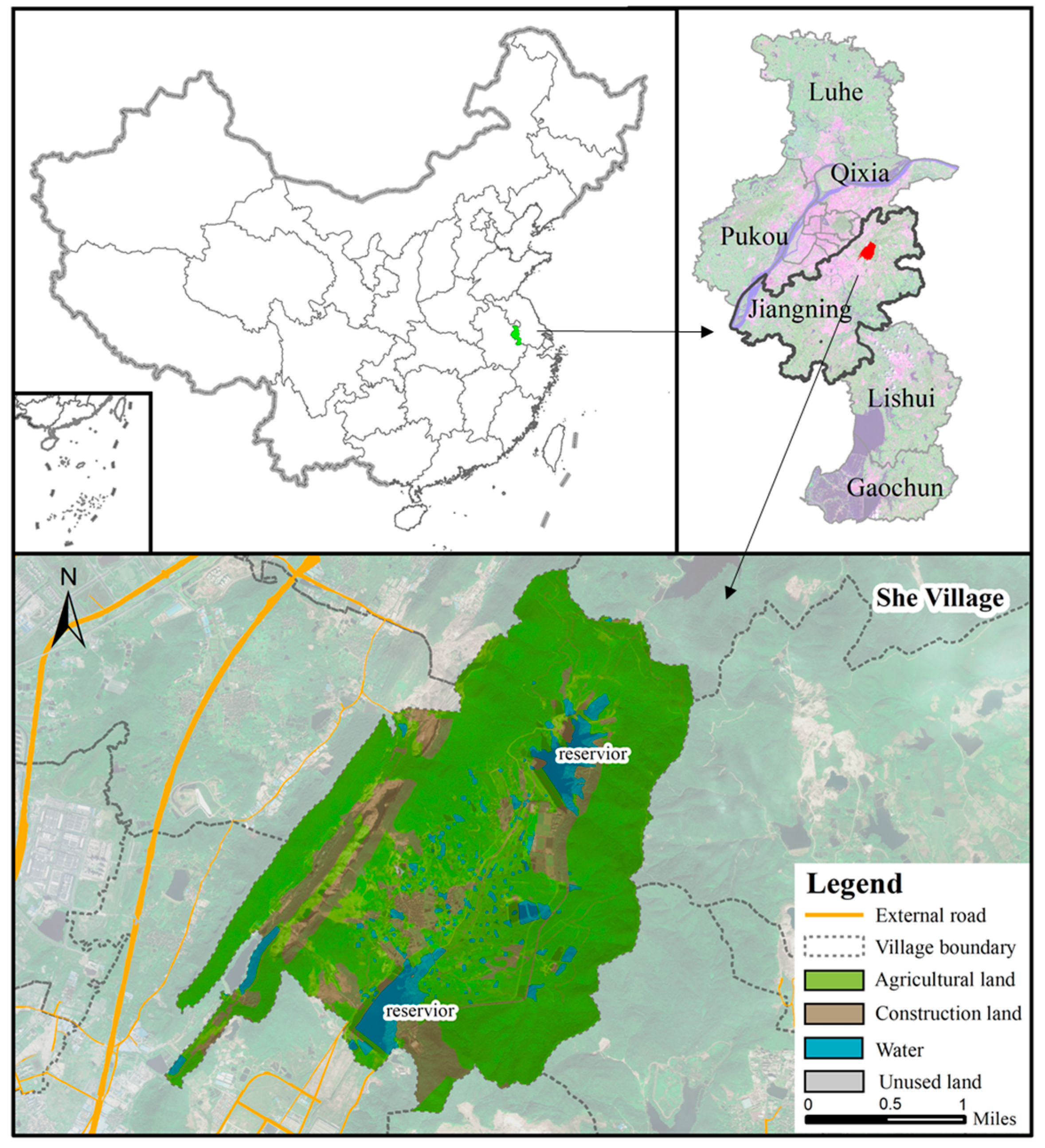
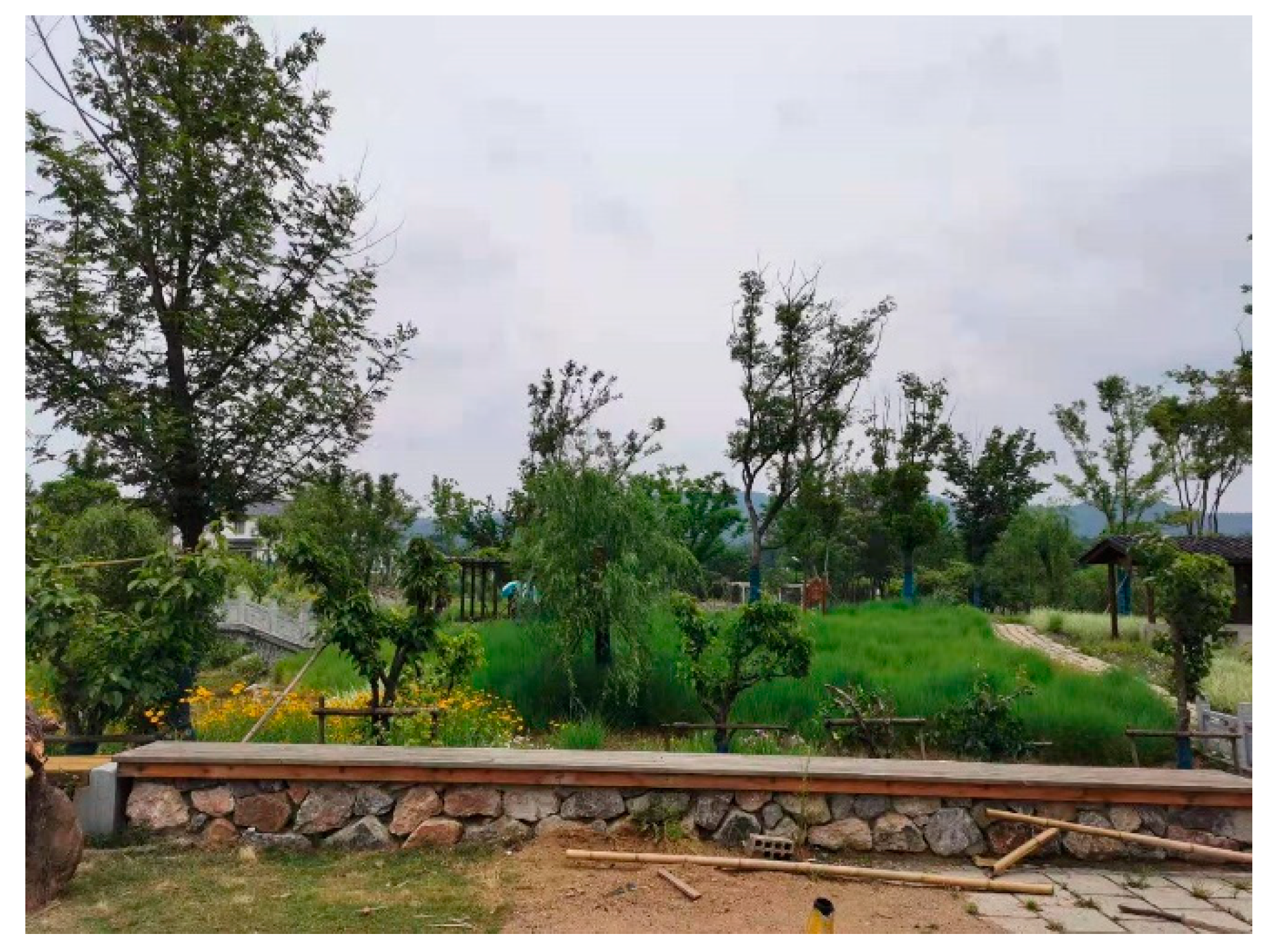
3.1. Study Area

Located at the western foot of Qinglong Mountains in Jiangning District, Nanjing, She Village is about 13 km away from the downtown area of the city, the topography of which is high in the northeast and low in the southwest. She Village enjoys convenience in transportation, as it is connected to 104 National Highway in the south and Nanjing Ring Expressway in the west (Figure 2). Also, the village abounds in tourism resources, such as the tombs of Sun Wu in Shangfang and the ancient Dou Village, located within 3 km around She Village. Covering a total area of 17.09 hm2, She Village has 583 farmer households with a total population of 2091 in 2018, among which the population of permanent residents is about 1680. The rate of nonagricultural employment is 100% with a per capita income of 37,000 yuan per year. Huanglong Mountains on the west side of She Village are rich in limestone, with good quality and abundant reserves. At present, the development of She Village is largely driven by ecological construction and rural tourism. In the future, it is expected to become a multifunctional and idyllic village that can offer tourists rich experience in farming and leisure sports.

3.2. Date Sources

The relevant land-use data used in this paper consisted of remote sensing images of She Village in 2000 and 2016 with a spatial resolution of 30 m, results of the third national land survey of Jiangning District, Nanjing in 2018. Rural socioeconomic data were mainly derived from the Protection and Development Planning of Traditional Villages, The Overall Plan for Rural Tourism Development in Nanjing, and first-hand information from field research.

3.3. Methods

Land-use classification. Based on the classification proposed by the third national land survey, this paper divided the land-use types into 8 categories in light of the resolution of remote sensing images, including cultivated land, forest land, garden land, grassland, residential land, commercial and service facility land, industrial and mining land, public management service land, transportation land, water and water conservancy facilities land, and other land.
Stage division. This paper mainly adopted the qualitative division method based on key events. Industrial development of She Village began in 1980. The Grain for Green Project, an ecological restoration project in the whole region, and land consolidation were implemented successively since 2000, which led to the shutdown of industrial enterprises. Beautiful Countryside Construction and tourism development were carried out in 2016. The three clear-cut time periods of 1980–2000, 2000–2016, and 2016–2018, which witnessed industrial development, ecological restoration, and service industry development, respectively, were established, shedding light on the characteristics of She Village’s development stage.
Analysis of land-use change. The participatory rural appraisal (PRA) was introduced to collect historical land-use data to invert the process of land spatial expansion from 1980 to 2018 and draw land-use maps of 1980, 2000, 2016, and 2018. ArcGIS spatial analysis tool and the land-use transfer matrix [32] were used to visualize spatial changes in land-use types and quantify the conversion among different land-use categories, respectively. Net change ( N j ) was introduced to measure the absolute difference between the increased area and decreased area in the land-use matrix. The calculation formula of net change ( N j ) is as follows [33]:
N j = MAX ( S j + S j j ,   S + j S j j ) M I N ( S j + S j j ,   S + j S j j ) = | S j + S j + |
where N j stands for net change of the j-th land-use type, S j + refers to the total area of the j-th land-use type converted to other land-use types, and S j + refers to the total area of the j-th land-use type converted from other land-use types. In order to reveal the case in which the net change was 0 due to the mutual transformation of different land-use types of the equal area at different locations, swap change ( D j ) was used to describe the relative area change of a certain land-use type transferred to other land-use types in situ and other land-use types transferred to the j-th land-use type at other locations [20]. The formula is as follows:
D j = 2 × M I N ( S j + S j j   ,   S + j S j j )
where D j represents the swap change of the j-th land-use type. The net change and swap change of each land-use type together constitute the total land-use change ( W j ), and its formula is as follows:
W j = N j + D j =   MAX ( S j + S j j ,   S + j S j j ) + M I N ( S j + S j j ,   S + j S j j )
in which the total land-use change is equal to the sum of the increased area and decreased area. It is worth noting that the total net change and swap change of the region are 1/2 of the sum of net change and exchange change of each land type, since the total area of the region is certain. The expansion intensity index (M) was introduced to quantify the expansion speed of construction land in different periods [34] and its formulas is as follows:
M = U × 100 A × Δ t
where U refers to the area converted from nonconstruction to construction land, A is the total area of the study area, and Δ t is the duration of a certain period.

4. Results

4.1. Land-Use Transition of She Village

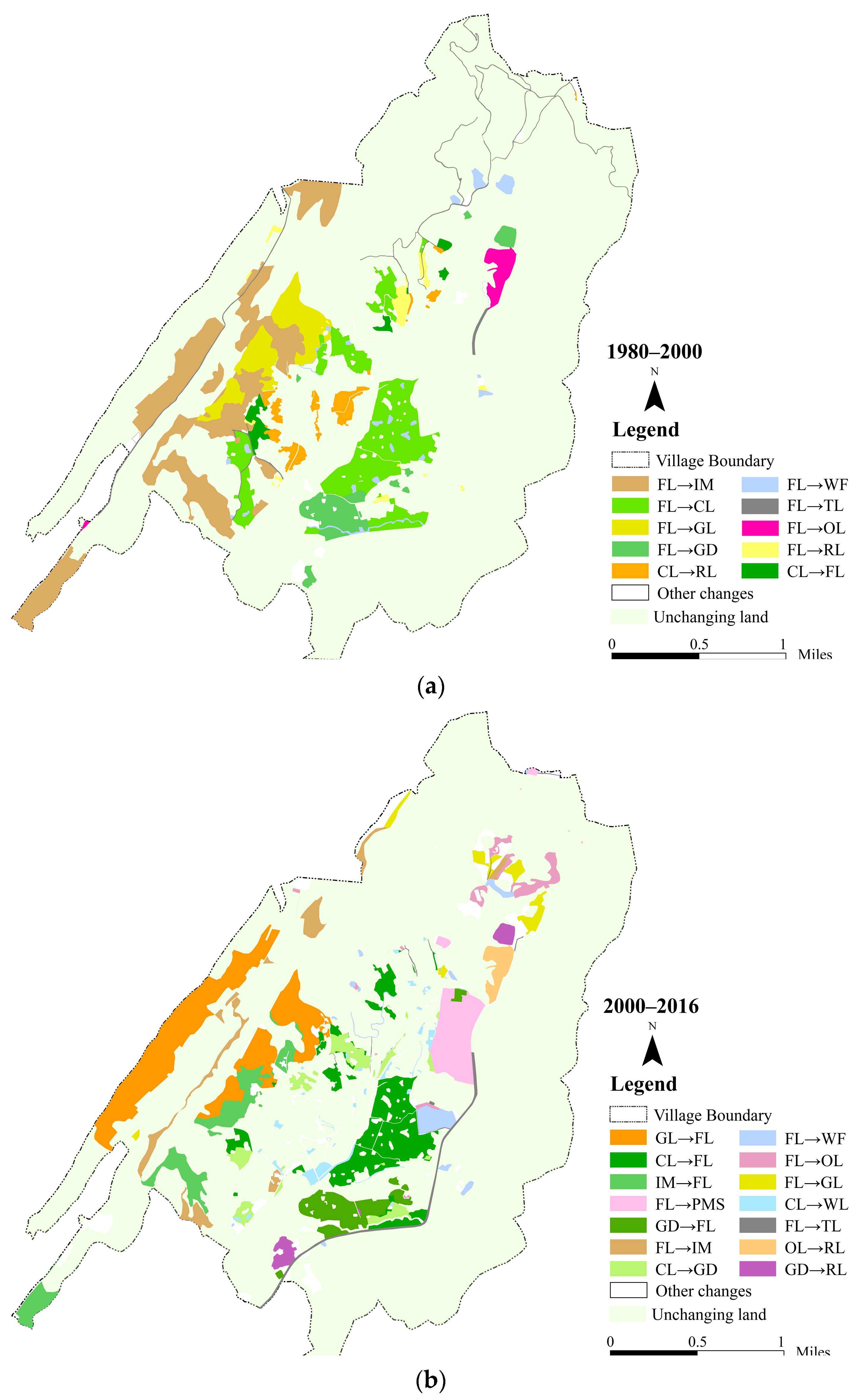
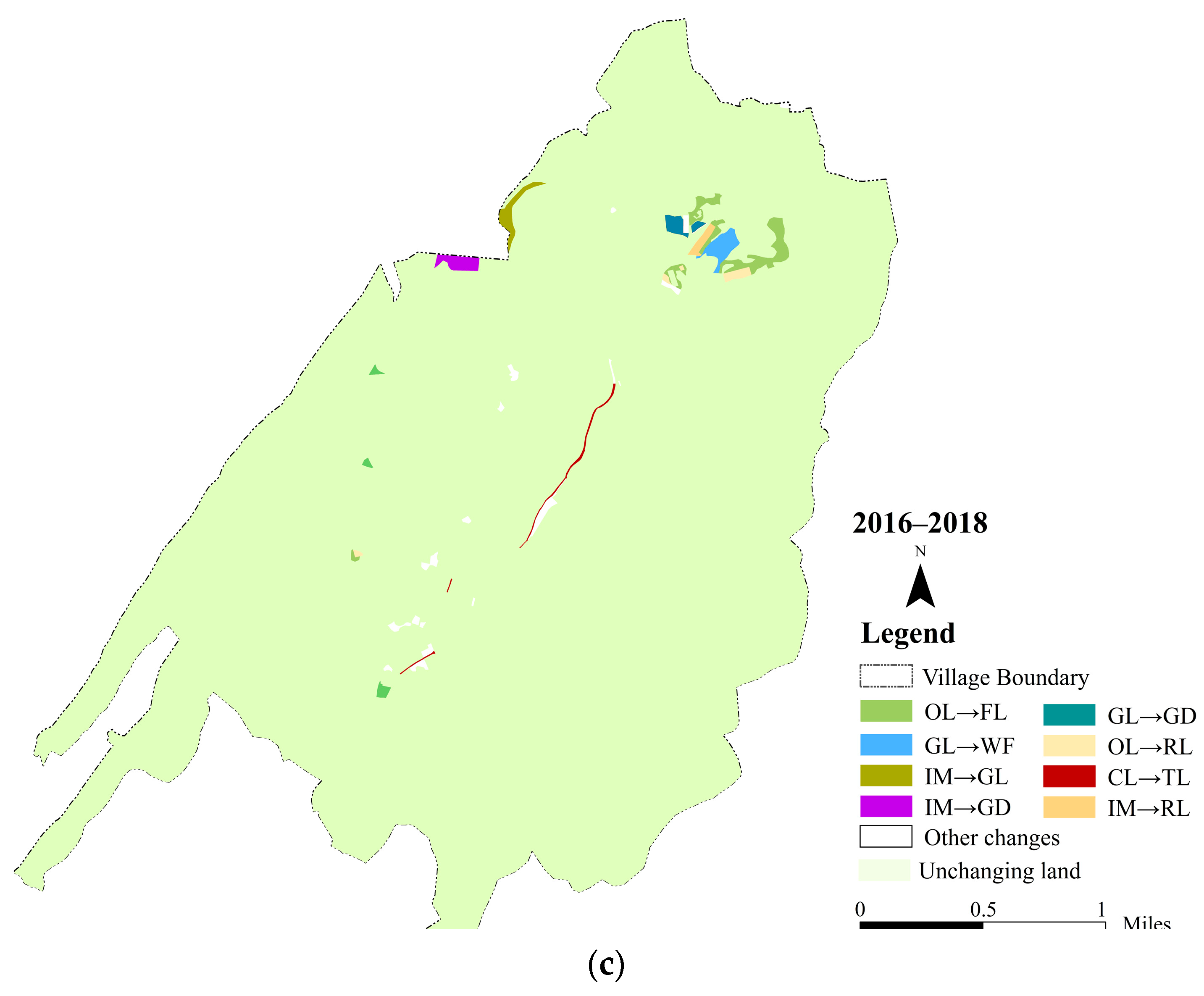
4.1.1. Dominant Morphology of Land-Use Transition in She Village

Before 1980, given the restrictions imposed by the planned economy and production factors, such as capital, the land-use structure in the village was mainly based on agricultural land, such as forest land and cultivated land, supplemented by construction land, such as industrial and mining land and residential land. Over the last 40 years or so, She Village witnessed a rapid transformation of land-use quantity and spatial structure (Table 1, Figure 3 ). ① During 1980 to 2000, the land use change of She Village mainly featured the conversion between forest land and other land-use types. The proportion of forest land decreased by 13.81%, while that of cultivated land, grassland, and industrial and mining land increased by 3.73%, 2.33%, and 7.13%, respectively. Residential land and grassland increased by 25.45 hm2 and 25.84 hm2, with an amplification rate of 231.79% and 147.50%. The area of the remaining land-use types all increased slightly. Forest land had the greatest total land-use change of 317.75 hm2, and was the only land-use type with a reduction in net change, mainly transferring to industrial and mining land, cultivated land, and grassland by 120.34 hm2, 84.14 hm2, and 36.80 hm2, respectively, with an account for more than 75% of the total reduced area of forest land. Moreover, the swap change of construction land consisted of residential land, commercial and service facility land, industrial and mining land, public management service land, and transportation land was 0, while net change increased, which indicated the accelerated expansion of village in the study area. ② During 2000 to 2016, land-use change was contrary to the previous stage, but the internal conversions between land-use types were more complex. Forest land increased by 5.48%, while cultivated land, grassland, and industrial and mining land decreased by 5.27%, 0.32%, 4.49%, and 1.26%, respectively. Residential land continued to grow, mainly occupying forest land, garden land, and other land, with an increase of 25.26 hm2. Due to the allotment of the collectively owned land, 29.71 hm2 of forest land were transferred into public management service land which had an explosive growth. Forest land was still the land type with the greatest total change—the area transferred to 206.11 hm2 from 112.47 hm2. It is worth noting that the swap change of other land was 20.15 hm2, accounting for 91.05% of the total land-use change. The swap change was similar to the total land-use change, which means that a large number of spatial location shifts had taken place in the case of a small change in the total amount of other land. ③ During 2016 to 2018, the land-use structure of She Village tended to be stable, and slight changes happened in different land-use types, mainly concentrated in the north of the study area. The main changes were the decrease of 7.06 hm2 and 9.92 hm2 of industrial and mining land and other land, and the increase of 7.8 hm2 of forest land mainly transferred from other land, accounting for 85.28% of the area converted to forest land. On the one hand, the net change of garden land and grassland increased, and there was a certain amount of swap change on the other hand, and the swap change was large, which indicated that the garden land and grassland mainly changed in location. The commercial and service facility land, by continuously replacing or recombining industrial land and residential land, expanded to14.19 hm2, with a growth rate of 55.93%, thus leading to commercial–residential mixed and industrial–commercial mixed land-use patterns, and the diversified land-use characteristics (Table 2).
The diversification of land-use types and quantity structure led to the change of spatial layout. The village is located between two mountains and surrounded by vast forests and farmland, forming a ladder layout composed of houses, streets and alleys, reservoirs, farmlands, and mountains (Figure 4). ① In 1980, the spatial layout of land-use in She Village consisted of public management service land, residential land, cultivated land, and forest land from center to edge, forming a concentric circle structure of “public service area—traditional residential area—agricultural production area—forestry area”. Pan’s ancestral hall, Pan’s ancient building complex, and Jiulong ridge, together, constituted the center of the rural settlement in She Village, among which the ancestral hall had the function of public service by providing office space for the village committee. The traditional residence maintained an ancient style of cyan bricks and black tiles, extending to the south and north from the center of the settlement, and connected to the reservoir. The periphery of the traditional residence was contiguous cultivated land, garden land, and forest land. She Village presented a centralized layout pattern with a compact internal structure. Buildings were distributed along contour lines, high in the north and low in the south, and formed a diverse spatial layout together with the latticed streets and lanes. ② In 2000, rapid industrialization led to an explosive expansion of the industrial and mining land. Eight industrial and mining enterprises were put into operation in She Village over the past two decades, which formed an industrial belt along Huanglong and Qinglong Mountain on the west side of She Village and occupied a large expanse of agricultural space. The development of mining industries caused degradation of forests and the increasing area of bare mountains, which further squeezed the space for agricultural production eastward. Significant changes also took place in the internal structure of agricultural land, where the cultivated land expanded eastward, occupying the original forest land, and creating a new fan-shaped area eastward based on the original ring structure. In the late 1990s, with the population growth and households division, a vast expanse of residential land increased. Modern residences expanded along the periphery of traditional ones, gathering together at each node of the road network. Also, they were distributed in a discrete way, breaking the tight spatial layout of the village. During this period, the spatial change of land use in She Village featured the establishment of industrial areas, expansion of mining areas, scattered growth of residential areas, and the emergence of a small portion of commercial land, contributing to the more mixed spatial layout of She Village. ③ In 2018, after ecological restoration and the development of the tertiary industry, the spatial layout of land use was further diversified. Through the listing and auction of land parcels, urban residential land emerged and squeezed part of the agricultural production area and forestry area. Forest area was restored in the east of the village after the policy of Grain for Green came into effect, and the mining land, once occupied forests and farmland, was shrunk with the implementation of the comprehensive rehabilitation of mining area. The space for agricultural production tended to be contracted, fragmented, and decentralized. Currently, the layout of She Village is a concentric circle structure, with public service facilities as the core, traditional and modern residences as the inner circle, agricultural production areas as the intermediate circle, and forestry and industrial areas as the outer circle. Commercial service areas, part of modern residential areas and public service areas, have replaced part of agricultural production area and are distributed between the agricultural circle and the forest circle along the rural road, in the form of clumps (Figure 4). During the construction of demonstration villages, She Village repaired and protected historic buildings and demolished the sheds, toilets, and temporary houses etc., which were done by villagers privately. The internal structure of the village was upgraded by optimizing the rural road network system and strengthening the bonds between primary and secondary roads.

4.1.2. Recessive Morphology of Land-Use Transition in She Village

With the rapid changes in the dominant morphology of land use, recessive morphology of land use has transferred in She Village, especially cultivated land, forest land, industrial and mining land, and residential land, in terms of ownership, management modes and entities, input and output, and functions. From 1980 to 2018, land-use intensity of She Village increased from 3.18% to 15.90%, and the expansion intensity of construction land in the three stages was 46.70%, 37.79%, and 21.38% respectively (Table 3). In view of the limited new construction land quotas, the expansion of construction land will gradually stabilize. The road network in the village was further improved and the road network density increased from 0.56% to 2.14%.
In the early 1980s, the implementation of the household contract responsibility system led to the separation of contracted management rights of cultivated land from farmers’ collective land ownership. At the same time, the management of cultivated land transferred from cooperative operation to household operation, and the cultivated land, mainly undertook agricultural production functions. With the outflow of local labor force who should have been engaged in agricultural production, the cultivated lands were gradually marginalized, some of which were abandoned and others subcontracted between farmers. Grains were replaced by cash crops, such as coleseeds and tea trees, and the proportion of planting areas of grain crops decreased from 86.70% in 1980 to 45.34% in 2018. At the beginning of 2016, more than one-third of the cultivated land in this village was left deserted. Except for the land reserved by the farmers, the village transferred 90% of the cultivated land to large farms for unified management at a price of 700 yuan/mu, and the rest was leased. With the development of landscape agriculture, cultivated land had both the multifunction of agricultural production and ecology conservation. In addition to the expansion and contraction in quantity and area, the function of industrial and mining land changed remarkably. Some abandoned mining areas, suffering from rain erosion all year round, formed a special landform similar to the “Yadan landform”, which has become a new business card for external publicity of She Village. She Village, taking advantage of the vertical drop of some mine pits, created a rafting tourism product, resulting in the transformation of industrial production function to tourism function. Due to the rapid and disorderly expansion of industrial land, large-scale exploitation activities led to the deterioration of the quality of surrounding soil, serious degradation of 47.15 hm2 forest land to grassland, and damage to ecological functions. In 2003, 2000 mu of cultivated land was returned to forest land, which was allocated to the forest farm at a price of 700 yuan/mu for ecological restoration and management. The ecological function of the forest land was restored year by year. In addition, part of the collectively owned forest land was allocated for state-owned land to build a football training base without any compensation, leading to the land-use function transferring to public service function. Forest land developed the compound function of ecology and tourism by combining health and wellness tourism. The residential land in the village initially assumed the residential function, with a small proportion for self-employment to provide commodities to the villagers. But later, production functions were added to it because of the diversification of targeted groups and management entities. Under such circumstances, rural households made great efforts to develop agritainments, homestay inns, and other activities through independent operation and commissioned operation. Some merchants directly rented idle rural houses for commercial production. All these led to the bifunction of residence and production of rural housing land.

4.2. Driving Forces of Land-Use Transition in She Village

4.2.1. Main Driving Forces of Each Stage

Since the beginning of the 1980s, the land-use morphology of She Village has experienced rapid transformation and development, which has been led by local organizations and rural elites, and driven by the dual influence of both urban and rural systems. She Village has undergone a shift from passive development to active development due to its favorable geographical location, effective policies, and abundant resources.
During the stage of industrial development from 1980 to 2000, mineral resources, particularly limestone, and population growth were the dominant factors that shaped the land-use morphology of She Village. Relying on such abundant limestone, many township enterprises kept cropping up, including several quarries and lime factories. Meanwhile, large amounts of raw materials were continuously transported to Nanjing, Ma’an shan, and other places to support national construction. Industrial enterprises obtained high profits by mining and processing industrial raw materials. The flourishing of mining industry also profoundly changed the landform morphology of Huanglong Mountain in She Village. With the constant growth of population in She Village, villagers cultivated new land and built new houses in order to meet their agricultural production and living needs, leading to the expansion of cultivated and residential areas in the village. The production and operation activities by farmers and industrial enterprises became the main driver for the shrinkage of forest land.
During the stage of ecological restoration from 2000 to 2016, the national macro policy and the transfer of urban functions were the main driving forces for the changes in land-use morphology of She Village. In the early 2000s, the policy of Grain for Green was put into practice across the board, which led to the closure of industrial and mining enterprises in She Village. In line with the land consolidation campaign, the village carried out an all-round ecological restoration project, including mine rehabilitation, which reshaped the land-use morphology of She Village. The implementation of these policies resulted in the loss of industrial jobs and restrictions on agricultural production. Since the income from agricultural production alone could not meet their living needs, a majority of farmers turned to nonagricultural sectors to make a livelihood transformation and looked for jobs in nearby towns and cities, which caused a buildup of desolated farm land. At the same time, some public services and residential functions of cities were transferred to the suburbs due to reduced costs in transportation and land price advantage, leading to the mixture of rural and urban land in the suburbs.
During the stage of service industry development from 2016 to 2018, various behavior subjects, including local government and organizations, urban residents, and commercial business operators, together with other factors, such as market demand, location advantages and regional policies, promoted the reallocation of production factors of She Village, creating a new direction for the development of the village and the evolution of land-use morphology. Thanks to rapid industrialization and urbanization, the tourism industry in She Village, only 13 km away from the downtown area of Nanjing, enjoyed inherent advantages to prosper, as urban residents had a stronger demand for pastoral landscape and rural life experience. In 2017, the tourism-oriented development orientation of She Village was completely settled, when the Beautiful Countryside Construction and other relevant policies and blueprints were put into place to support tourism development of this village in many aspects, including construction of sewage pipelines, cleaning of river ponds, improvement of infrastructure, etc. Commercial tenants and other service business operators changed the property rights structure, management modes, and land functions of rural land by renting houses and lands. The local organizations acted as key intermediaries to negotiate with the government, business entities, and the nonindigenous farmers on behalf of the villagers in regards to the price of land acquisition, land transfer, and land leasing. All the cultivated land in the village was transferred and managed by the large farmer households in a unified manner, which transformed the decentralized management mode of cultivated land.

4.2.2. Changes in the Impact Intensity of Driving Forces

The driving forces that dominated the land-use transition of different stages in She Village were different, and each driving force showed different intensity in each stage of land-use transition of She Village. The intensities of these driving forces of land-use transition in She Village were mainly manifested in four changing trends: “periodically intermittent”, “increase–increase–increase”, “increase–decrease–increase”, and “increase–decrease–decrease” (Figure 5).
The periodically intermittent trend has mainly been presented by the impact intensity of the implementation of regional and national policies, including the household contract responsibility system, Grain for Green, and Beautiful Countryside Construction, which injected impetus to the evolution of land-use morphology into the three time stages of She Village. These policies can deliver rapid and strong impacts on relevant land parcels in a certain period of time, with an intensity increasing first and then decreasing. The changes in relevant lands reach saturation and gradually stabilize. The influence process of the policies and systems have stopped, but the influence result is continuous.
The increasing–increasing–increasing trend has mainly manifested as the impact intensity of urban radiation and diffusion. With the improvement of She Village’s external transportation, the flow of production factors between the downtown area of Nanjing and She Village has been strengthened. The stage of industrial development features the outflow of industrial raw materials. The stage of ecological restoration features the outflow of labor forces and inflow of real-estate capital. The two-way flow of population between urban and rural areas, together with an influx of industrial and commercial capital, is the characteristic of the rural–urban flow of production factors during stage of service industry development. As a result, She Village’s production mode has been changed, with functional transformation facilitated and land-use transition strengthened under the radiation of the downtown area.
The trends of increase–decrease–increase and increase–decrease–decrease have mainly manifested as the intensity of rural endogenous impetus, such as natural resources and population, in the land-use transition. Mineral resource is the primary factor of industrial development and the most representative natural resource in She Village. At the stage of ecological restoration, the exploitation of mineral resources was restricted and the expansion of mining land slowed down due to social–ecological negative feedback, leading to a reduced impact on land-use change. At the stage of service industry development, landscapes in rural areas, such as mountains, water, forests, and fields, have become new consumer goods, a magnet for urban residents. This trend, therefore, gave birth to the development of tourism in this village, which triggered further transformation in its land use. The population in She Village showed a trend of increasing first and then decreasing during three stages. The increase in population in the industrial development period brought about the expansion of cultivated land and homesteads. During the stage of ecological restoration and service industry development, the population drain and the decreasing dependence on land lead to the decreasing direct reconstruction of the land by villagers.

5. Discussion

5.1. Problems in the Process of Land-Use Transformation in She Village

Rural transformation and development is not only an opportunity for the adjustment of rural industries and improvement of living environments, but also a typical period during which man–land contradictions and conflicts between people keep cropping up [35]. Some problems stood out during the transformation and development of She Village.
The land-use transition in She Village, dominated by national and regional policies, has caused instability of the development in She village due to its rapid and little-adjustable implementation process. At the stage of ecological restoration, the policy of Grain for Green directly led to the elimination of the mining industry in She Village, which greatly slashed the financial revenue. In the following decade, the economic development of the village was stagnant, delivering a negative impact on the income of ordinary farmers and the development of the village. In addition, rapid transformation and development will inevitably cause unsustainable land use [36]. She Village preliminarily completed the Beautiful Countryside Construction program according to the village planning within two years. Field research found that some of the lands in the village were in a deserted state due to the lack of effective follow-up management, such as the untended flower beds that had overgrown with weeds, leading to the failure of the realization of the expected land functions (Figure 6). Moreover, after the development of tourism, villagers’ consciousness of service was weak, which hadn’t shifted from meeting their own needs to those of tourists, reflected by the fact that some villagers cleaned up the flowers and plants used for landscaping around their houses for vegetable planting and stacked the square with junk. The public space of the village has transferred from the simple production and living space of the villagers to the consumption and operating space of tourists and operators [20]. Villagers’ market consciousness had not yet been established in the rapid rural transformation.
Unable to share rural development dividends with villagers. At the stage of industrial development, the collective economic organization could not afford the cost of mining due to the weak economic foundation of She Village. As a result, other village collectives obtained mining rights at a lower price and almost occupied all profits, while only some employment opportunities with low incomes were left for villagers in She Village. At the stage of ecological restoration, the real estate developers acquired land-use rights for commercial buildings. With the improved environment of She Village and growing demand of urban residents for a second house, the land price in She Village rose, but the value-added part was grabbed by real-estate developers instead of villagers. At the stage of service industry development, a small number of rural households who left the village became rentiers by collecting rents. However, more villagers who stayed in the village suffered from the lack of knowledge in operating modes and commodity packaging, as well as the high cost of house renovation [37], which made it difficult for them to compete with commercial tenants in the development of tertiary industries, such as accommodation and catering. The development dividend of She Village is mainly occupied by industrial and commercial capitalists, while the villagers are excluded from the rentiers.
Lagging reconstruction of local organizations. At present, the tourism-oriented land- use transition has been basically completed, and the prosperity of tertiary industry has also taken shape. However, the organizational restructuring in the structure of “people–land–industry” is greatly lagging behind in She Village. The increasing mobility of the rural population and the growing participation of urban residents and industrial and commercial operators are undermining the traditional rural social network and the community system, which are based on blood and geographical relationship [38]. The traditional Chinese village is a manners-controlled society, which is governed by the village covenant, and is on the verge of collapse under the impact of modernism. The mode of “rural governance”, with the government as its core, under which village committees, social organizations, and rural residents are marginalized and subordinated, is no longer suitable for rural development.

5.2. Implications of Suburban Land-Use Transformation for Rural Transformation

Suburban villages, as the front belt of urbanization, the pilot area of agricultural modernization, the coordination area of urban and rural relations, and the ecological barrier of the city [22], have a general trend of weakening rurality and strengthening urbanism [39]. The village not only provides production and living space for the villagers, but also undertakes the function of ecological conservation, part of which is transferred from urban areas [40]. Due to their miscellaneous population, industry. and land use, the study on the trend and influence mechanism of land-use change in suburban villages is enlightening to the transformation and development of other villages.
Multifunctional land use is an effective way of rural transformation. The essence of rural recession is the alienation or degradation of rural regional functions. However, the rural revitalization is the optimization or enhancement of rural regional functions [41]. Two types of transformations of She Village have been caused by the degradation of industrial production function and the enhancement of tourism service function. Rural land-use transition is not a process of linear replacement. Specifically, the transition should promote the compound use of agricultural land through the application of new technology, large-scale management, agricultural tourism development, and other ways, giving full play to its ecological and production functions. The construction land mainly undergoes functional expansion on the basis of the original residential and production functions combined with the development of commercial retail, catering and accommodation, and new entertainment projects.
The improvement of the property rights system and land revenue distribution institution is the key to rural transformation. The contradiction between the fixity of land and the mobility of population leads to the waste of land resources [42], reflected by the abandonment of homesteads and cultivated land, which is a major obstacle to rural transformation. At the same time, unclear property rights of some land prevent companies and large planters from promoting the transfer of farmland [43]. Under the current rural land contract management system, the cash crop production model with family management as the mainstay faces many challenges, such as difficulty in expanding the scale of land, improving the industrial level, and extending the industrial chain. In addition, in the income distribution link of land circulation, the subjects participating in income distribution are not clear and the proportion of income distribution is diverse with no clear stipulation, which leads to little enthusiasm of farmers participating in the marketization of collective commercial construction land. Therefore, the improvement of the property rights system and land revenue distribution institution is an important driving force for the current rural transformation and development.

5.3. Research Shortage

Compared with previous research, this paper studied land-use transition from a dual perspective of dominant and recessive morphology and emphasizes the influence of urban radiation and diffusion on suburban villages, which can fully show the evolution of land use in suburban villages and contribute to a better understanding of rural urbanization. Given the complexity of the rural regional system, and the diversity of rural types and land-use transition channels, this study has the following deficiencies: due to the long time span, it was difficult to obtain land-use data on village scale, and part of the research content can only be supported by information obtained through a participatory evaluation method for qualitative analysis rather than quantitative analysis. The tourist villages in suburbs have different development paths [44] under different dominant factor, including government, commercial capital, or villagers [45]. This paper only provided analysis for the tourism-oriented rural land-use transition led by the government. Therefore, it is necessary to carry out the comparative study on tourist villages under different dominant factors.
Moreover, in the context of rural transformation, tourism development has become an important way for rural transformation in suburbs, while problems such as industrial homogenization, excessive commercialization of agriculture, and gentrification of social space [46] come one after another. A number of issues need further study, including how to effectively combine the driving forces of land-use transition and promote the transformation and development of suburban villages, how to properly develop a multifunctional countryside that can benefit villagers, and how to avoid rural space developing into a pure consumption space while protecting the spatial development rights of villagers in rural tourism transformation to ensure the sustainability of land-use transition.

6. Conclusions

During rapid urbanization and industrialization, this tourism village has witnessed a clear-cut transition in their land use, which can be divided into three stages, namely, the stages of agricultural development, industrial development, and service industry development. The change of land-use morphology shows distinct characteristics at each stage, which is led by top-down government policies and driven by the endogenous force of a village and the radiation and diffusion of a city. The overall trend is concluded as follows. The residential land first expanded, then the growth rate slowed down to zero. The area of land for agricultural production and industrial production first increased and then decreased. The area of public services and commercial service land increased continuously. She Village tended to have diversified land-use types, intensive and reasonable land-use layout, activated land ownership, complicated functions, and diverse management modes and entities.
From 1980 to 2018, She Village underwent two transformations “industrial development—ecological restoration—rural tourism development”. The quantity and spatial structure underwent a drastic restructuring, and the degree of land fragmentation was intensified. The land-use characteristics of “commercial–residential mixed” and “tourism redevelopment of industrial land” emerged. Now, a concentric circle structure has been formed, which is “public service area—traditional residential area—modern residential area—agricultural production area—forest area and industrial area” from inside to outside. The diversification of land property rights and business entities, from local farmers to nonlocal rich farmers and commercial enterprises, have led to multifunctional and complex land issues. The multifunctional land for production and ecology, or for residence and production, has become the mainstream. Rural space has experienced the transformation from living and production space to consumption space.
Over the past four decades, the dominant factors driving rapid land-use transition in She Village were different at each stage. The land-use transition during the stage of industrial development was driven by natural resources and population growth; during ecological restoration, driven by the national macro policies and the transfer of urban functions; and during service industry development, driven by market demand, location advantages, regional policies, and the interaction between various subjects of land use. The national and regional policies played a decisive role in the two periods of transformation and development of She Village. Different driving forces had different impact intensities at each stage of the land-use transition of She Village. Natural resource, urban radiation and diffusion, population growth, and national and regional policies showed four changing trends of periodically intermittent, increase–increase–increase, increase–decrease–increase, and increase–decrease–decrease, respectively.

Author Contributions

Conceptualization, K.J.; data curation, Y.C. and Y.H.; funding acquisition, W.Q.; investigation, Y.W.; methodology, Y.C.; resources, W.Q.; software, T.H.; supervision, T.F. writing—review and editing, Y.C. All authors have read and agreed to the published version of the manuscript.

Funding

This research was funded by National Natural Science Foundation of China (41871178, 41901204) and Natural Resources and Technology Program of Jiangsu Province (KJXM2019012, KJXM2019005, KJXM2019009).

Data Availability Statement

No new data were created or analyzed in this study. Data sharing is not applicable to this article.

Acknowledgments

We especially thank the National Natural Science Foundation of China for funding this study.

Conflicts of Interest

The authors declare no conflict of interest.

References

  1. Hoggart, K.; Paniagua, A. What rural restructuring? J. Rural Stud. 2001, 17, 41–62. [Google Scholar] [CrossRef]
  2. Liu, S.; Wang, Y. From Native Rural China to Urban-rural China: The Rural Transition Perspective of China Transformation. Manag. World 2018, 34, 128–146. [Google Scholar] [CrossRef]
  3. Tu, S.; Long, H.; Zhang, Y.; Ge, D.; Qu, Y. Rural restructuring at village level under rapid urbanization in metropolitan suburbs of China and its implications for innovations in land use policy. Habitat Int. 2018, 77, 143–152. [Google Scholar] [CrossRef]
  4. Lange, A.; Piorr, A.; Siebert, R.; Zasada, I. Spatial differentiation of farm diversification: How rural attractiveness and vicinity to cities determine farm households’ response to the CAP. Land Use Policy 2013, 31, 136–144. [Google Scholar] [CrossRef]
  5. Holmes, J. Impulses towards a multifunctional transition in rural Australia: Gaps in the research agenda. J. Rural Stud. 2006, 22, 142–160. [Google Scholar] [CrossRef]
  6. Jia, K.; Qiao, W.; Chai, Y.; Feng, T.; Wang, Y.; Ge, D. Spatial distribution characteristics of rural settlements under diversified rural production functions: A case of Taizhou, China. Habitat Int. 2020, 102, 102201. [Google Scholar] [CrossRef]
  7. Yansui, L.; Long, H.; Chen, Y.; Wang, J.; Li, Y.; Li, Y.; Yang, Y.; Zhou, Y. Progress of research on urban-rural transformation and rural development in China in the past decade and future prospects. J. Geogr. Sci. 2016, 26, 1117–1132. [Google Scholar] [CrossRef]
  8. Meyfroidt, P.; Chowdhury, R.R.; de Bremond, A.; Ellis, E.C.; Erb, K.-H.; Filatova, T.; Garrett, R.D.; Grove, J.; Heinimann, A.; Kuemmerle, T.; et al. Middle-range theories of land system change. Glob. Environ. Chang. 2018, 53, 52–67. [Google Scholar] [CrossRef]
  9. Long, H.; Zou, J.; Pykett, J.; Li, Y. Analysis of rural transformation development in China since the turn of the new millennium. Appl. Geogr. 2011, 31, 1094–1105. [Google Scholar] [CrossRef]
  10. Ma, W.; Jiang, G.; Wang, D.; Li, W.; Guo, H.; Zheng, Q. Rural settlements transition (RST) in a suburban area of metropolis: Internal structure perspectives. Sci. Total Environ. 2018, 615, 672–680. [Google Scholar] [CrossRef]
  11. Long, H.; Qu, Y. Land use transitions and land management: A mutual feedback perspective. Land Use Policy 2018, 74, 111–120. [Google Scholar] [CrossRef]
  12. Ge, D.; Wang, Z.; Tu, S.; Long, H.; Yan, H.; Sun, D.; Qiao, W. Coupling analysis of greenhouse-led farmland transition and rural transformation development in China’s traditional farming area: A case of Qingzhou City. Land Use Policy 2019, 86, 113–125. [Google Scholar] [CrossRef]
  13. Long, H.; Ge, D.; Wang, J. Progress and Prospects of the Coupling Research on Land Use Transitions and Rural Transformation Development. Acta Geogr. Sin. 2019, 74, 2547–2559. [Google Scholar] [CrossRef]
  14. Su, K.; Yang, Q.; Zhang, B.; Zhang, Z. The Coupling Mechanism between Rural Land Use Transition and Small-scale Peasant Economy Change in Mountainous Areas. Geogr. Res. 2019, 38, 399–413. [Google Scholar] [CrossRef]
  15. Long, H.; Tu, S. Land Use Transition and Rural Vitalization. China Land Sci. 2018, 32, 1–6. [Google Scholar] [CrossRef]
  16. Ge, D.; Zhou, G.; Qiao, W.; Yang, M. Land use transition and rural spatial governance: Mechanism, framework and perspectives. J. Geogr. Sci. 2020, 30, 1325–1340. [Google Scholar] [CrossRef]
  17. Zhang, B.; Sun, P.; Jiang, G.; Zhang, R.; Gao, J. Rural land use transition of mountainous areas and policy implications for land consolidation in China. J. Geogr. Sci. 2019, 29, 1713–1730. [Google Scholar] [CrossRef] [Green Version]
  18. Yang, R. Spatial Differentiation and Mechanisms of Typical Rural Areas in the Suburbs of a Metropolis: A Case Study of Beicun Village, Baiyun District, Guangzhou. Acta Geogr. Sin. 2019, 74, 1622–1636. [Google Scholar] [CrossRef]
  19. Tu, S.; Long, H.; Zhang, Y.; Zhou, X. Process and Driving Factors of Rural Restructuring in Typical Villages. Acta Geogr. Sin. 2019, 74, 125–141. [Google Scholar] [CrossRef]
  20. Jiang, K.; Liu, Z.; Li, Y.; Wang, Y.; Wang, Y. Land use change of typical villages in the loess hilly and gully region and implications for regional rural transformation and development. Prog. Geogr. 2019, 38, 1305–1315. [Google Scholar] [CrossRef]
  21. Liu, Y.; Long, H. Land use transitions and their dynamic mechanism: The case of the Huang-Huai-Hai Plain. J. Geogr. Sci. 2016, 26, 515–530. [Google Scholar] [CrossRef] [Green Version]
  22. Xi, J.; Zhao, M.; Ge, Q.; Kong, Q. Changes in Land Use of a Village Driven by over 25 Years of Tourism: The Case of Gougezhuang village, China. Land Use Policy 2014, 10, 119–130. [Google Scholar] [CrossRef]
  23. Zhu, L.; Li, L.; Liu, S.; Li, Y. The evolution of village land use function in the metropolitan suburbs and its inspiration to rural revitalization: A Case Study of Jiangjiayan Village in Chengdu City. Geogr. Res. 2019, 38, 535–549. [Google Scholar] [CrossRef]
  24. Li, B.; Zhou, X.; Liu, P.; Chen, C.; Liu, Y. Function Transformation and Spatial Reconstructuring of Zhangguying Village in Urbanization. Sci. Geogr. Sin. 2018, 38, 1310–1318. [Google Scholar] [CrossRef]
  25. Zou, L.; Liu, Y.; Yang, J.; Yang, S.; Wang, Y.; Zhi, C.; Hu, X. Quantitative identification and spatial analysis of land use ecological-production-living functions in rural areas on China’s southeast coast. Habitat Int. 2020, 100, 102182. [Google Scholar] [CrossRef]
  26. Chen, Y.; Zhou, J. The Evolution Process and Spatial Layout Patterns of Land Use in Urban Fringe Areas. Urban Plan. Overseas 1998, 2, 10–16. [Google Scholar]
  27. Chen, Y.; Wu, W. An Analysis on the Man-land System and its Dynamics in Urban-rural Interlocking Belt. Sci. Geogr. Sin. 1998, 18, 418–424. [Google Scholar]
  28. Lapola, D.M.; Martinelli, L.A.; Peres, C.A.; Ometto, J.P.H.B.; Ferreira, M.E.; Nobre, C.A.; Aguiar, A.P.D.; Bustamante, M.M.C.; Cardoso, M.F.; Costa, M.H.; et al. Pervasive transition of the Brazilian land-use system. Nat. Clim. Chang. 2014, 4, 27–35. [Google Scholar] [CrossRef] [Green Version]
  29. Liang, X.; Jin, X.; Ren, J.; Gu, Z.; Zhou, Y. A research framework of land use transition in Suzhou City coupled with land use structure and landscape multifunctionality. Sci. Total Environ. 2020, 737, 139932. [Google Scholar] [CrossRef] [PubMed]
  30. Luo, Y.; Zhou, C.S. The Review and Outlook on Urban-rural Fringe Studies in China. Urban Stud. 2005, 12, 25–30. [Google Scholar]
  31. Hu, S.; Tong, L.; Long, H. Land Use Transition Potential and its Assessment Framework. Geogr. Res. 2019, 38, 1367–1377. [Google Scholar] [CrossRef]
  32. Zhu, H.; Li, X. Discussion on the Index Method of Regional Land Use Change. Acta Geogr. Sin. 2003, 58, 643–650. [Google Scholar]
  33. Zhu, D. Methods for Detecting Land Use Changes Based on the Land Use Transition Matrix. Resour. Sci. 2010, 32, 1544–1550. [Google Scholar]
  34. Liu, S.; Wu, C.; Shen, H. A GIS based model of urban land use growth in Beijing. Acta Geogr. Sin. 2002, 55, 407–416. [Google Scholar]
  35. Yang, N.; Long, H.; Liu, Y.; Zhang, Y. Research Progress and Prospect of Rural Transformation and Reconstruction in China: Paradigms and Main Content. Prog. Geogr. 2015, 34, 1019–1030. [Google Scholar] [CrossRef] [Green Version]
  36. Ristic, D.; Vukoicic, D.; Milincic, M. Tourism and Sustainable Development of Rural Settlements in Protected Areas Example NP Kopaonik (Serbia). Land Use Policy 2019, 89, 104231. [Google Scholar] [CrossRef]
  37. Tao, H.; Huang, Z.; Ran, F. Rural Tourism Spatial Reconstruction Model from the Perspective of ATV: A Case Study of Mufu Township, Hubei Province, China. Sustainability 2018, 10, 2675. [Google Scholar] [CrossRef] [Green Version]
  38. Yao, G.; Xie, H. Rural spatial restructuring in ecologically fragile mountainous areas of southern China: A case study of Changgang Town, Jiangxi Province. J. Rural. Stud. 2016, 47, 435–448. [Google Scholar] [CrossRef]
  39. Zhang, J.; Jiang, K.F. Analyzing Capital Logic Behind Rural Construction Boom in Contemporary China. Mod. City Stud. 2016, 31, 2–8. [Google Scholar]
  40. Tian, J.; Wang, B.; Cheng, L.; Wang, S. The Process and Mechanism of Regional Land Use Transition Guided by Policy: A Case Study of Northeast China. Geogr. Res. 2020, 39, 805–821. [Google Scholar] [CrossRef]
  41. Zhou, Y.; Li, X.; Liu, Y. Rural land system reforms in China: History, issues, measures and prospects. Land Use Policy 2020, 91, 104330. [Google Scholar] [CrossRef]
  42. Ge, D.; Long, H.; Zhang, Y.; Ma, L.; Li, T. Farmland transition and its influences on grain production in China. Land Use Policy 2018, 70, 94–105. [Google Scholar] [CrossRef]
  43. Ge, D.; Long, H.; Qiao, W.; Wang, Z.; Sun, D.; Yang, R. Effects of rural–urban migration on agricultural transformation: A case of Yucheng City, China. J. Rural Stud. 2020, 76, 85–95. [Google Scholar] [CrossRef]
  44. He, T.; Qiao, W.; Jia, K.; Chai, Y.; Hu, Y.; Sun, P.; Wang, Y.; Feng, T. Selecting Rural Development Paths Based on Village Multifunction: A Case of Jingjiang City, China. Complexity 2020, 2020, 1–15. [Google Scholar] [CrossRef]
  45. Huang, J. Rural Revitalization: Rural Transformation, Structural Transformation and Government’s Functions. Issues Agric. Econ. 2020, 481, 4–16. [Google Scholar] [CrossRef]
  46. Zasada, I. Multifunctional peri-urban agriculture—A review of societal demands and the provision of goods and services by farming. Land Use Policy 2011, 28, 639–648. [Google Scholar] [CrossRef]
Figure 1. The driving forces of land-use transition in tourist villages.
Land 10 00168 g001
Figure 2. The location of She Village.
Land 10 00168 g002
Figure 3. (a) Major internal conversions between land-use types from 1980 to 2000; (b) major internal conversions between land-use types from 2000 to 2016; (c) major internal conversions between land-use types from 2016 to 2018.
Land 10 00168 g003aLand 10 00168 g003b
Figure 4. Land-use spatial structure in 1980, 2000 and 2018.
Land 10 00168 g004
Figure 5. Changes in the impact intensity of driving forces.
Land 10 00168 g005
Figure 6. Unrealized leisure function.
Land 10 00168 g006
Table 1. Quantity change of various types of land in She Village from 1980 to 2018.
Land-Use Type1980200020162018
Area/hm2PercentArea/hm2PercentArea/hm2PercentArea/hm2Percent
CL118.406.62%176.8510.34%86.695.07%85.274.94%
FL1359.8175.99%1062.9862.18%1156.6367.66%1164.4367.40%
GD17.520.98%43.362.54%37.922.22%40.532.35%
GL55.983.13%93.315.46%16.610.97%14.180.82%
RL10.980.61%36.432.13%61.693.61%64.843.75%
IM32.111.79%152.538.92%131.047.67%123.997.18%
CSF1.060.06%3.290.19%13.580.79%14.190.82%
PMS0.540.03%1.510.09%31.371.83%32.301.87%
TL9.680.54%20.301.19%34.602.02%36.702.12%
WL96.035.37%108.456.34%126.917.42%130.527.56%
OL7.410.41%10.520.62%12.490.73%2.570.15%
CL: cultivated land; FL: forest land; GD: garden land; GL: grassland; RL: residential land; CSF: commercial and service facility land; IM: industrial and mining land; PMS: public management service land; TL: transportation land; WL: water and water conservancy facilities land; OL: other land.
Table 2. Land-use change in study area, 1980–2018.
Land-Use TypeCLFLGDGLRLIMCSFPMSTLWLOL
1980–2000ATI85.4410.4626.3037.3225.45120.412.220.9610.6213.419.05
ATO26.99307.290.460000000.995.94
TC112.42317.7526.7737.3225.45120.412.220.9610.6214.4014.99
NC58.45296.8225.8437.3225.45120.412.220.9610.6212.423.11
SC53.9720.930.920000001.9811.88
2000–2016ATI2.83206.1128.0716.0625.9122.0610.6029.8614.9421.0812.05
ATO92.99112.4733.5192.760.65149.550.3100.642.6310.07
TC95.82318.5961.58108.8126.56171.6210.9129.8615.5823.7122.13
NC90.1693.645.4476.7025.26127.4910.3029.8614.2918.451.98
SC5.66224.9556.1432.111.2944.130.6101.295.2620.15
2016–2018ATI1.849.244.082.383.640.030.610.942.093.640
ATO3.261.431.474.810.497.000009.93
TC5.1010.675.557.194.137.100.610.942.093.649.93
NC1.427.812.612.433.167.040.610.942.093.649.93
SC3.682.872.944.760.980.0600000
ATI: area transferred from other land-use types; ATO: area transferred to other land-use types; TC: the total land-use change; NC: net change; SC: swap change.
Table 3. The expansion intensity of construction land in She Village from 1980 to 2018.
Stages Expansion Area (m2)Expansion Intensity (%)
1980–2000159.6846.70%
2000–2016103.3837.79%
2016–20187.3121.38%
Publisher’s Note: MDPI stays neutral with regard to jurisdictional claims in published maps and institutional affiliations.

