Land Consolidation Zoning in Coastal Tidal Areas Based on Landscape Security Pattern: A Case Study of Dafeng District, Yancheng, Jiangsu Province, China


Abstract
1. Introduction
2. Data and Method
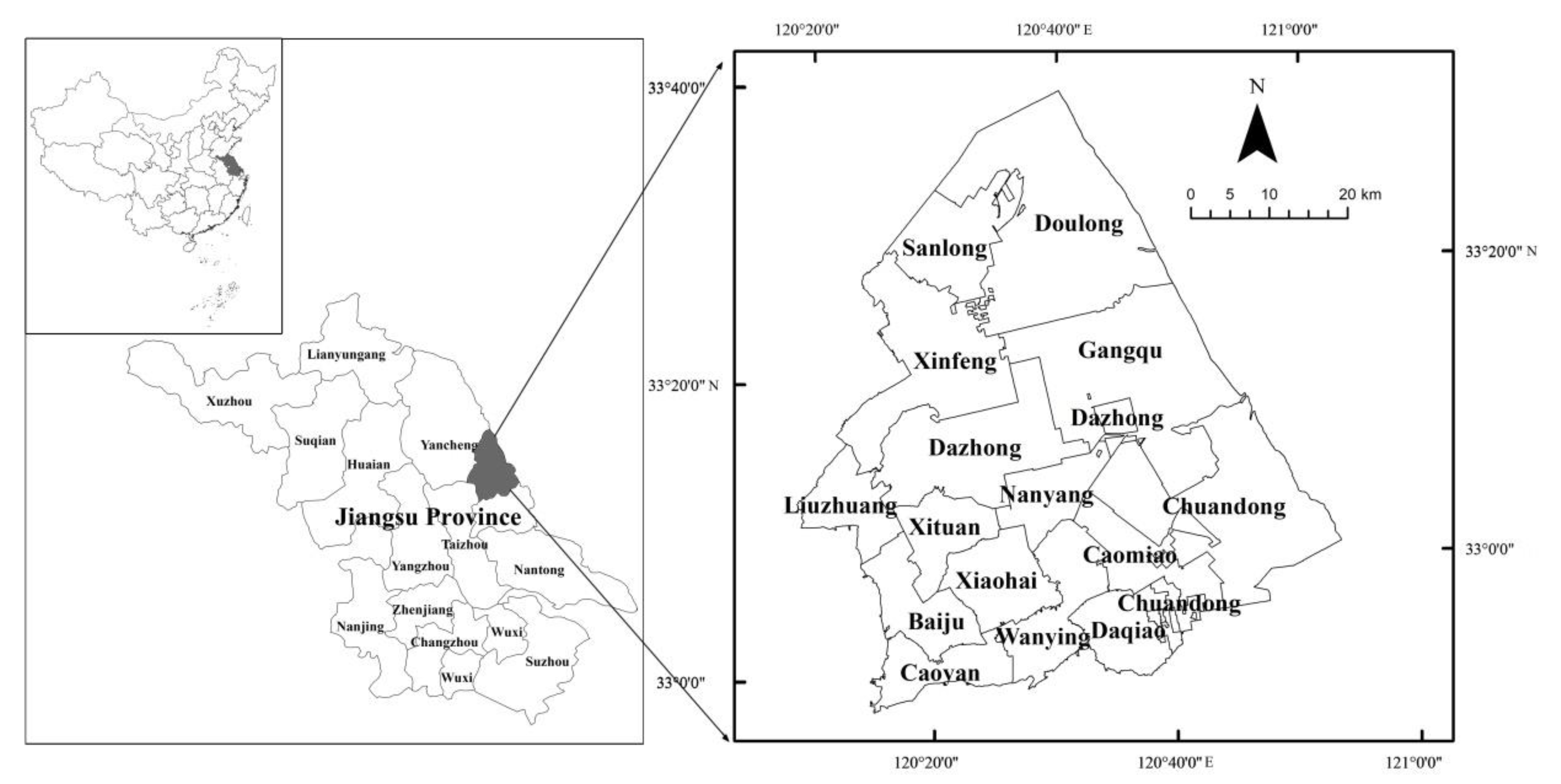
2.1. Study Areas
2.2. Data Sources and Processing
3. Research Methods
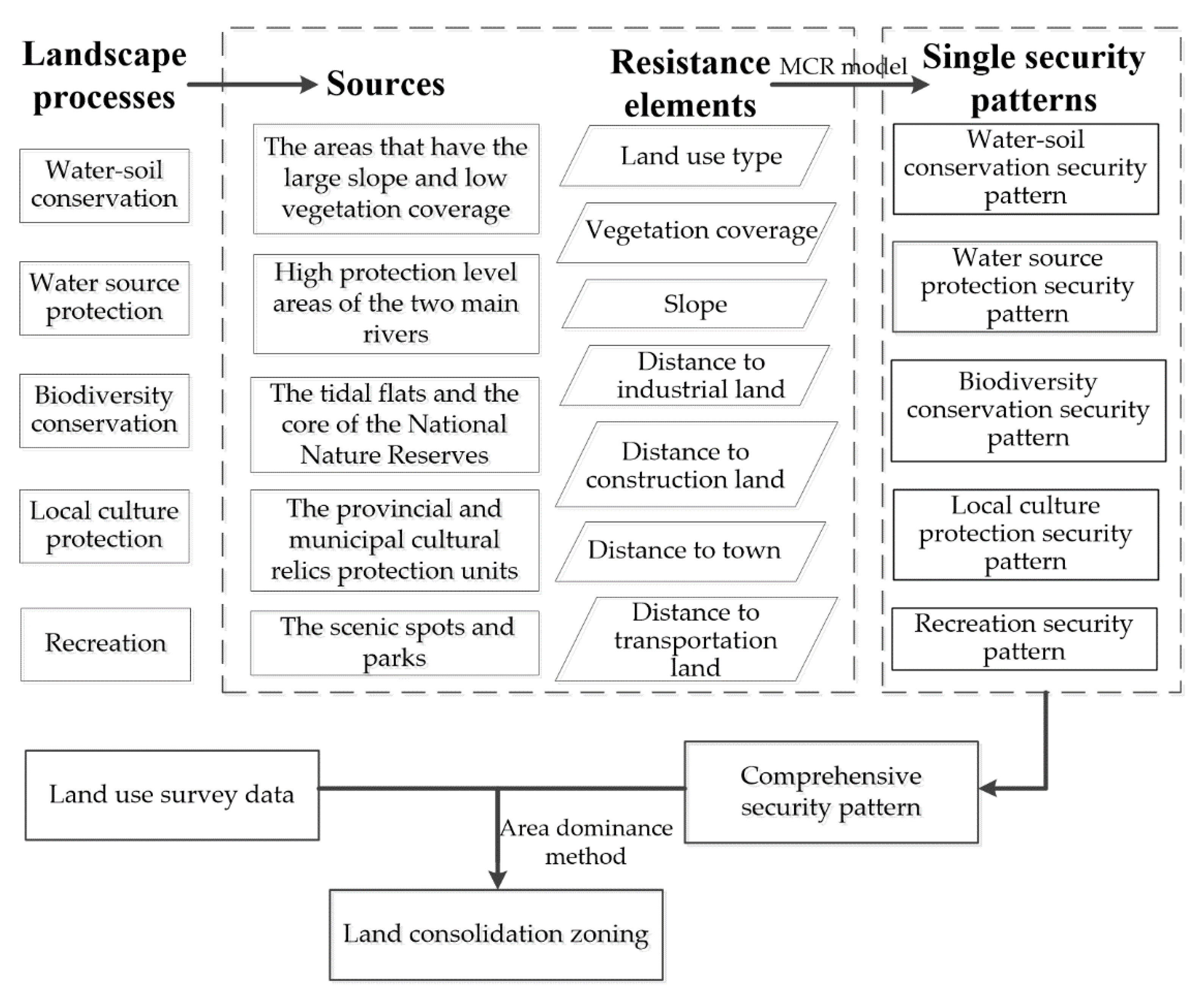
- The main landscape processes closely related to land consolidation in the coastal tidal area were explored by field investigation;
- The key points (namely the source) and the resistance elements in each landscape process were found out by literature review and field investigation. Using reclassify and natural breaks method in ArcGIS 10.3, the resistance elements were classified into 9 grades according to their values;
- In the present study, the minimum cumulative resistance model (MCR) was employed to identify the minimum cumulative value of resistance to be overcome from the source to a certain location in space. The equationfor the model is as follows [26]:
- 4.
- Single landscape ecological security patterns were constructed based on the MCR values, and a comprehensive landscape ecological security pattern was further constructed by overlaying the single patterns, adopting the weight-average method [11]. All of the patterns were obtained using the raster calculator and divided into low, medium, and high levels using the natural breaks method in ArcGIS 10.3;
- 5.
- Land consolidation zones were proposed in the Dafeng District according to the comprehensive landscape ecological security pattern, following its administrative division.
4. Results
4.1. Main Landscape Processes, Their Sources and Resistance Elements in Coastal Tidal Areas
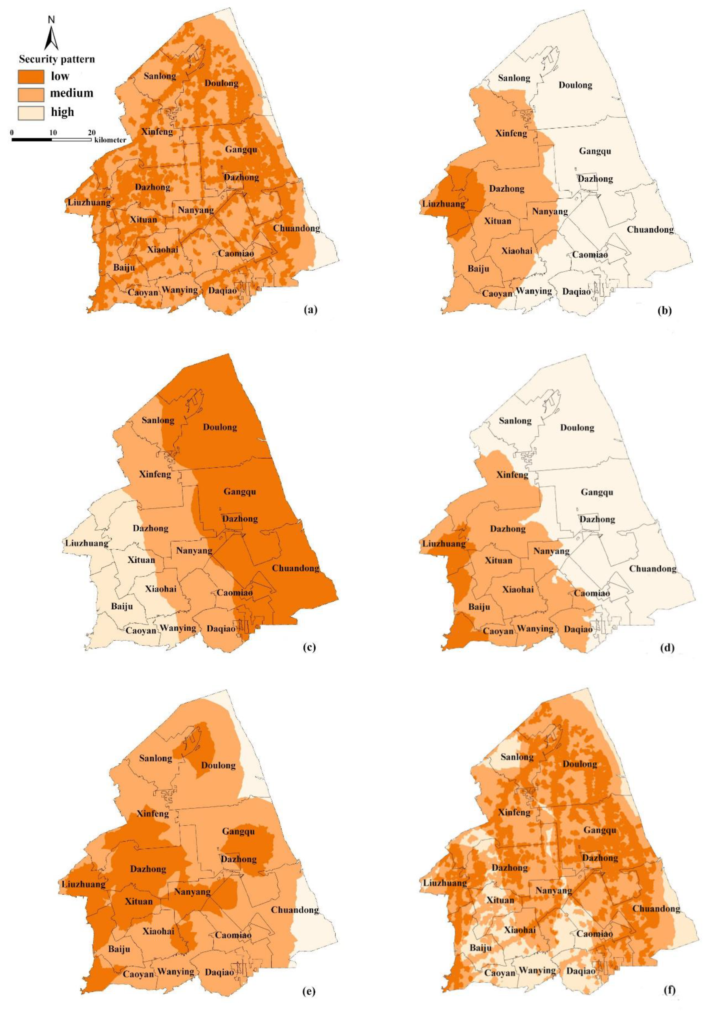
4.2. Single and Comprehensive Landscape Security Patterns in Coastal Tidal Areas
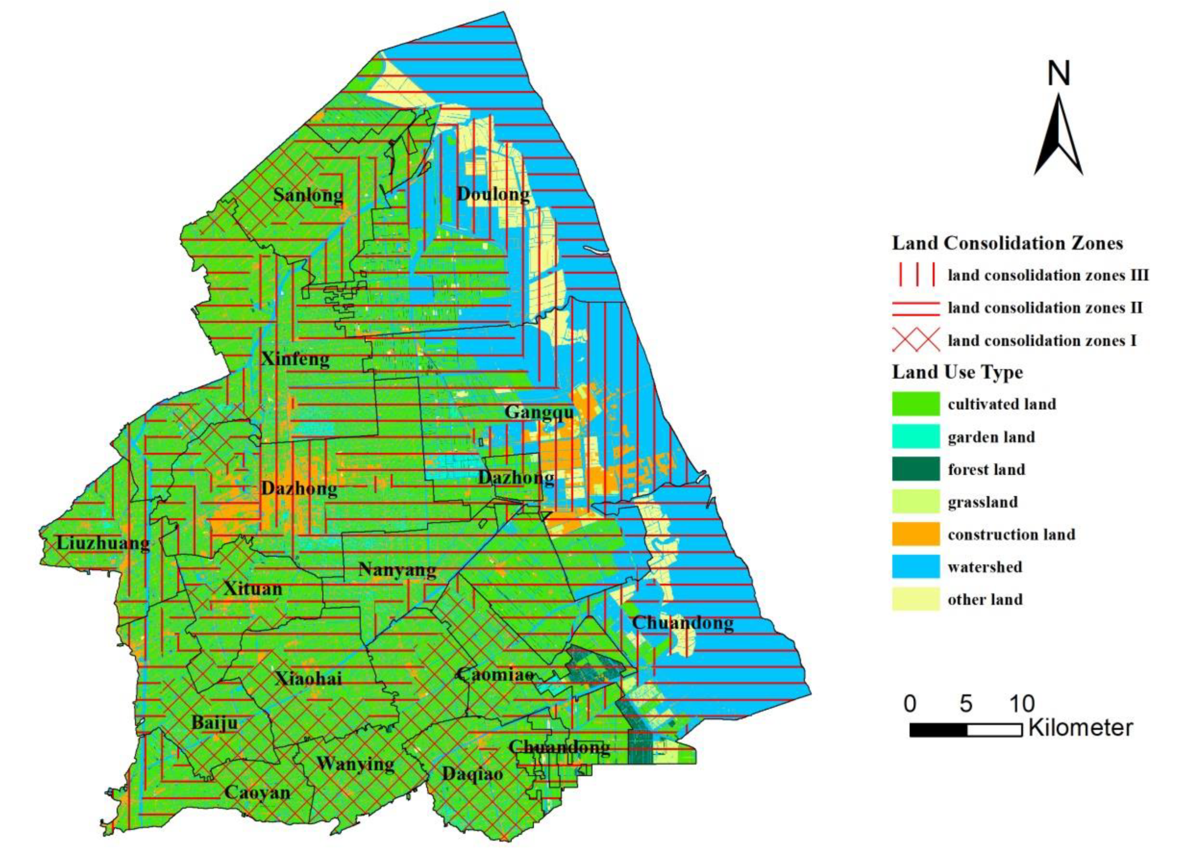
4.3. Land Consolidation Zones in Coastal Tidal Areas
5. Discussion
6. Conclusions
- Water-soil conservation process, water source protection process, biodiversity conservation process, local culture protection process, and recreation process were the main landscape processes in land consolidation in the Dafeng District. The areas that have the large slope and low vegetation coverage, high protection level areas of the two main rivers, the tidal flats and the core of the National Nature Reserves, the provincial and municipal cultural relics protection units, the scenic spots and parks were the sources of the processes, respectively. The resistance elements include land-use type, vegetation coverage, slope, distance to industrial land, distance to town, distance to construction land, and distance to transportation lands;
- Five single landscape security patterns were constructed, including water-soil conservation security pattern, water source protection security pattern, biodiversity conservation security pattern, local culture protection security pattern, and recreation security pattern. The comprehensive landscape security pattern of Dafeng District is obtained by overlaying the five single patterns and classified into three security levels: high, medium, and low. The areas of high and medium-security level account for 66.35% of the study area;
- Based on the comprehensive landscape safety pattern, the villages in the study area are categorized into land consolidation zone I, II, and III, which accounting for 25.62%, 58.04%, and 16.34% of the study area, respectively. According to their unique characteristics, the land consolidation must stress ecological protection in land consolidation zone I, either ecological protection or ecological restoration in land consolidation zone II, and ecological restoration in land consolidation zone III;
- The application of the theory of landscape security pattern in land consolidation zoning represented the idea of ecological priority. Specific suggestions on ecological protection and restoration are put forward in every land consolidation zone, which can guide land consolidation and regulation in coastal tidal areas. Still, there are some drawbacks to this article. First, the impact of other landscape processes on the land consolidation was not considered; this may influence the accuracy of the comprehensive landscape security pattern. Second, adopting the common method used in previous research, the natural breaks method was used in the classification of some resistance elements and landscape security patterns in this study. Although natural breaks classes are based on natural groupings inherent in the data, their applicability still needed to be verified. Furthermore, due to the limitation of data availability, this paper only constructs the landscape security pattern of the study area based on the data of 2016. Further research may enrich the subsequent data to study the temporal and spatial dynamic changes of landscape security patterns, investigate other landscape processes, and put forward classification methods more scientific and reasonable.
Author Contributions
Funding
Institutional Review Board Statement
Informed Consent Statement
Data Availability Statement
Acknowledgments
Conflicts of Interest
References
- Vitikainen, A. An overview of land consolidation in Europe. Nord. J. Surv. Real Estate Res. 2004, 1, 25–43. [Google Scholar]
- Uyan, M. Determination of agricultural soil index using geostatistical analysis and GIS on land consolidation projects: A case study in Konya/Turkey. Comput. Electron. Agric. 2016, 123, 402–409. [Google Scholar] [CrossRef]
- Demetriou, D.; Stillwell, J.; See, L. Land consolidation in Cyprus: Why is an Integrated Planning and Decision Support System required? Land Use Policy 2012, 29, 131–142. [Google Scholar] [CrossRef]
- Gallent, N.; Kim, K.S. Land zoning and local discretion in the Korean planning system. Land Use Policy 2001. [Google Scholar] [CrossRef]
- Ertunç, E.; Çay, T.; Haklı, H. Modeling of reallocation in land consolidation with a hybrid method. Land Use Policy 2018, 76, 754–761. [Google Scholar] [CrossRef]
- Pašakarnis, G.; Maliene, V. Towards sustainable rural development in Central and Eastern Europe: Applying land consolidation. Land Use Policy 2010, 27, 545–549. [Google Scholar] [CrossRef]
- Wójcik-Leń, J.; Leń, P.; Mika, M.; Kryszk, H.; Kotlarz, P. Studies regarding correct selection of statistical methods for the needs of increasing the efficiency of identification of land for consolidation—A case study in Poland. Land Use Policy 2019, 87, 104064. [Google Scholar] [CrossRef]
- Zhou, Y.; Guo, L.; Liu, Y. Land consolidation boosting poverty alleviation in China: Theory and practice. Land Use Policy 2019, 82, 339–348. [Google Scholar] [CrossRef]
- Wen, D. Land Mosaics: The Ecology of Landscapes and Regions. J. Environ. Qual. 1997. [Google Scholar] [CrossRef]
- Yu, K. Security Patterns in Landscape Planning with a Case Study in South China. Ph.D. Thesis, Harvard University, Cambridge, MA, USA, 1995. [Google Scholar]
- Yu, K. Security patterns and surface model in landscape ecological planning. Landsc. Urban Plan. 1996, 36, 1–17. [Google Scholar] [CrossRef]
- Zhou, W.; Huang, G.; Cadenasso, M.L. Does spatial configuration matter? Understanding the effects of land cover pattern on land surface temperature in urban landscapes. Landsc. Urban Plan. 2011, 102, 54–63. [Google Scholar] [CrossRef]
- Peng, J.; Li, H.; Liu, Y.; Hu, Y. Identification and optimization of ecological security pattern in Xiong’an New Area. Acta Geogr. Sin. 2018, 73, 701–710. [Google Scholar]
- Wang, D.; Chen, J.; Zhang, L.; Sun, Z.; Wang, X.; Zhang, X.; Zhang, W. Establishing an ecological security pattern for urban agglomeration, taking ecosystem services and human interference factors into consideration. PeerJ 2019, 7, e7306. [Google Scholar] [CrossRef] [PubMed]
- Yuanjing, Z.; Binyang, Y.; Ashraf, M.A. Ecological security pattern for the landscape of mesoscale and microscale land: A case study of the Harbin city center. J. Environ. Eng. Landsc. Manag. 2015, 23, 192–201. [Google Scholar] [CrossRef][Green Version]
- Asgarian, A.; Amiri, B.J.; Sakieh, Y. Assessing the effect of green cover spatial patterns on urban land surface temperature using landscape metrics approach. Urban Ecosyst. 2015, 18, 209–222. [Google Scholar] [CrossRef]
- Peng, J.; Pan, Y.; Liu, Y.; Zhao, H.; Wang, Y. Linking ecological degradation risk to identify ecological security patterns in a rapidly urbanizing landscape. Habitat Int. 2018, 71, 110–124. [Google Scholar] [CrossRef]
- Li, F.; Wang, Y.; Hu, Y.; Yao, X. Research on Yancheng Coastal Beach Reclamation Development and Ecological Environment Protection. J. Green Sci. Technol. 2013, 09, 155–157. [Google Scholar]
- Ruiz, R.S. Documento base para la elaboración de la “política nacional de ordenamiento integrado de las zonas costeras Colombianas”: Documento de consultoría. 1997. Available online: http://www.invemar.org.co/redcostera1/invemar/docs/1008PoliticaZonasCosterasE.pdf (accessed on 1 February 2021).
- Milanés Batista, C.; Suárez, A.; Botero Saltarén, C.M. Novel method to delimitate and demarcate coastal zone boundaries. Ocean Coast. Manag. 2017, 144, 105–119. [Google Scholar] [CrossRef]
- Balaguer, P.; Sardá, R.; Ruiz, M.; Diedrich, A.; Vizoso, G.; Tintoré, J. A proposal for boundary delimitation for integrated coastal zone management initiatives. Ocean Coast. Manag. 2008, 51, 806–814. [Google Scholar] [CrossRef]
- Brenner, J.; Jimenez, J.A.; Sardá, R. Definition of Homogeneous Environmental Management Units for the Catalan Coast. Environ. Manag. 2006, 38, 993–1005. [Google Scholar] [CrossRef]
- Amir, S. Classification of coastal resources: A Mediterranean case study. Landsc. Urban Plan. 1987, 14, 399–414. [Google Scholar] [CrossRef]
- Sardá, R.; Avila, C.; Mora, J. A methodological approach to be used in integrated coastal zone management processes: The case of the Catalan Coast (Catalonia, Spain). Estuar. Coast. Shelf Sci. 2005, 62, 427–439. [Google Scholar] [CrossRef]
- Liang, D.; Teng, L.; Huang, L.; Xie, X.; Zuo, Y.; Zhao, J. Dynamic Analysis of Urban Landscape Patterns of Vegetation Coverage Based on Multi-temporal Landsat Dataset. Comput. Comput. Technol. Agric. IX 2016, 478, 300–316. [Google Scholar] [CrossRef]
- Knaapen, J.P.; Scheffer, M.; Harms, B. Estimating habitat isolation in landscape planning. Landsc. Urban Plan. 1992, 23, 1–16. [Google Scholar] [CrossRef]
- Zhu, K.; Chen, Y.; Zhang, S.; Yang, Z.; Huang, L.; Lei, B.; Li, L.; Zhou, Z.; Xiong, H.; Li, X. Identification and prevention of agricultural non-point source pollution risk based on the minimum cumulative resistance model. Glob. Ecol. Conserv. 2020, 23, e01149. [Google Scholar] [CrossRef]
- Friedrich Michael Dimpel Wertungsübertragung und Kontiguität. Mit zwei Beispielen zur Wertung des Frageversäumnisses im Parzival. J. Lit. Theory 2012. [CrossRef]
- Zhang, Y.; Bi, Z.; Zhang, X.; Yu, Y. Influence of Landscape Pattern Changes on Runoff and Sediment in the Dali River Watershed on the Loess Plateau of China. Land 2019, 8, 180. [Google Scholar] [CrossRef]
- Lee, S.-H.; Kim, S.; Kim, H.-J. Effects of thinning intensity on understory vegetation in Chamaecyparis obtusa stands in South Korea. For. Sci. Technol. 2018, 14, 7–15. [Google Scholar] [CrossRef]
- Jaeger, J.A.G. Landscape division, splitting index, and effective mesh size: New measures of landscape fragmentation. Landsc. Ecol. 2000, 15, 115–130. [Google Scholar] [CrossRef]


| Reclassified Land Use Types | Contents |
|---|---|
| Cultivated land | Paddy field, dry land |
| Garden land | Mulberry garden, orchard, tea garden |
| Forest land | Arbor forest, shrub forest |
| Grassland | Grassland |
| Construction land | town, village, transportation land, industrial land, mining land |
| Watershed | river, lake, pond, tidal, marshland, reservoir |
| Other land | bare land, unused land |
| Resistance Coefficients | Resistance Elements | |||||||
|---|---|---|---|---|---|---|---|---|
| Land Use Type | Vegetation Coverage | Slope | Distance to Industrial Land (km) | Distance to Construction Land (km) | Distance to Town (km) | Distance to Transportation Land (−) (km) | Distance to Transportation Land (+) (km) | |
| 1 | Watershed | ≥0.459 | ≤2° | ≥11.35 | ≥6.473 | ≥12.01 | ≥7.84 | ≤0.47 |
| 2 | Forest land | 0.422–0.459 | 8.94–11.35 | 5.05–6.47 | 9.77–12.01 | 6.22–7.84 | 0.47–1.04 | |
| 3 | Garden land | 0.381–0.422 | 2°–6° | 7.04–8.94 | 3.92–5.05 | 7.80–9.77 | 4.75–6.22 | 1.04–1.68 |
| 4 | Grassland | 0.339–0.381 | 5.47–7.04 | 2.93–3.92 | 6.02–7.80 | 3.45–4.75 | 1.68–2.45 | |
| 5 | Cultiated land | 0.292–0.339 | 6°–15° | 4.15–5.47 | 2.02–2.93 | 4.49–6.02 | 2.45–3.45 | 2.45–3.45 |
| 6 | 0.247–0.292 | 3.02–4.15 | 1.20–2.02 | 3.22–4.49 | 1.68–2.45 | 3.45–4.75 | ||
| 7 | Construction land | 0.208–0.247 | 15°–25° | 2.02–3.02 | 0.54–1.20 | 2.12–3.22 | 1.04–1.68 | 4.75–6.22 |
| 8 | 0.171–0.208 | 1.06–2.02 | 0.16–0.54 | 1.03–2.12 | 0.47–1.04 | 6.22–7.84 | ||
| 9 | Other land | ≤0.171 | ≥25° | ≤1.06 | ≤0.16 | ≤1.03 | ≤0.47 | ≥7.84 |
| Kinds of Security Pattern | Levels | Area/hectares | Percent/% |
|---|---|---|---|
| Water-soil conservation security pattern | Low | 123,049.91 | 40.90 |
| Medium | 166,575.16 | 55.37 | |
| High | 11,205.64 | 3.72 | |
| Water source protection security pattern | Low | 16,342.6874 | 5.43 |
| Medium | 97,737.306 | 32.49 | |
| High | 186,750.7077 | 62.08 | |
| Biodiversity conservation security pattern | Low | 150,936.87 | 50.17 |
| Medium | 86,065.16 | 28.61 | |
| High | 63,828.68 | 21.22 | |
| Local culture protection security pattern | Low | 16,692.53 | 5.55 |
| Medium | 105,428.08 | 35.05 | |
| High | 178,710.10 | 59.41 | |
| Recreation security pattern | Low | 90,749.38 | 30.17 |
| Medium | 187,572.07 | 62.35 | |
| High | 22,509.27 | 7.48 | |
| Comprehensive security pattern | Low | 101,241.46 | 33.65 |
| Medium | 139,067.08 | 46.23 | |
| High | 60,522.20 | 20.12 |
Publisher’s Note: MDPI stays neutral with regard to jurisdictional claims in published maps and institutional affiliations. |
© 2021 by the authors. Licensee MDPI, Basel, Switzerland. This article is an open access article distributed under the terms and conditions of the Creative Commons Attribution (CC BY) license (http://creativecommons.org/licenses/by/4.0/).
Share and Cite
Xia, M.; Wang, L.; Wen, B.; Zou, W.; Ou, W.; Qu, Z. Land Consolidation Zoning in Coastal Tidal Areas Based on Landscape Security Pattern: A Case Study of Dafeng District, Yancheng, Jiangsu Province, China. Land 2021, 10, 145. https://doi.org/10.3390/land10020145
Xia M, Wang L, Wen B, Zou W, Ou W, Qu Z. Land Consolidation Zoning in Coastal Tidal Areas Based on Landscape Security Pattern: A Case Study of Dafeng District, Yancheng, Jiangsu Province, China. Land. 2021; 10(2):145. https://doi.org/10.3390/land10020145
Chicago/Turabian StyleXia, Min, Linyan Wang, Bo Wen, Wei Zou, Weixin Ou, and Zhongqiong Qu. 2021. "Land Consolidation Zoning in Coastal Tidal Areas Based on Landscape Security Pattern: A Case Study of Dafeng District, Yancheng, Jiangsu Province, China" Land 10, no. 2: 145. https://doi.org/10.3390/land10020145
APA StyleXia, M., Wang, L., Wen, B., Zou, W., Ou, W., & Qu, Z. (2021). Land Consolidation Zoning in Coastal Tidal Areas Based on Landscape Security Pattern: A Case Study of Dafeng District, Yancheng, Jiangsu Province, China. Land, 10(2), 145. https://doi.org/10.3390/land10020145