The Return of Wooded Landscapes in Wales: An Exploration of Possible Post-Brexit Futures
Abstract
1. Introduction
2. Materials and Methods
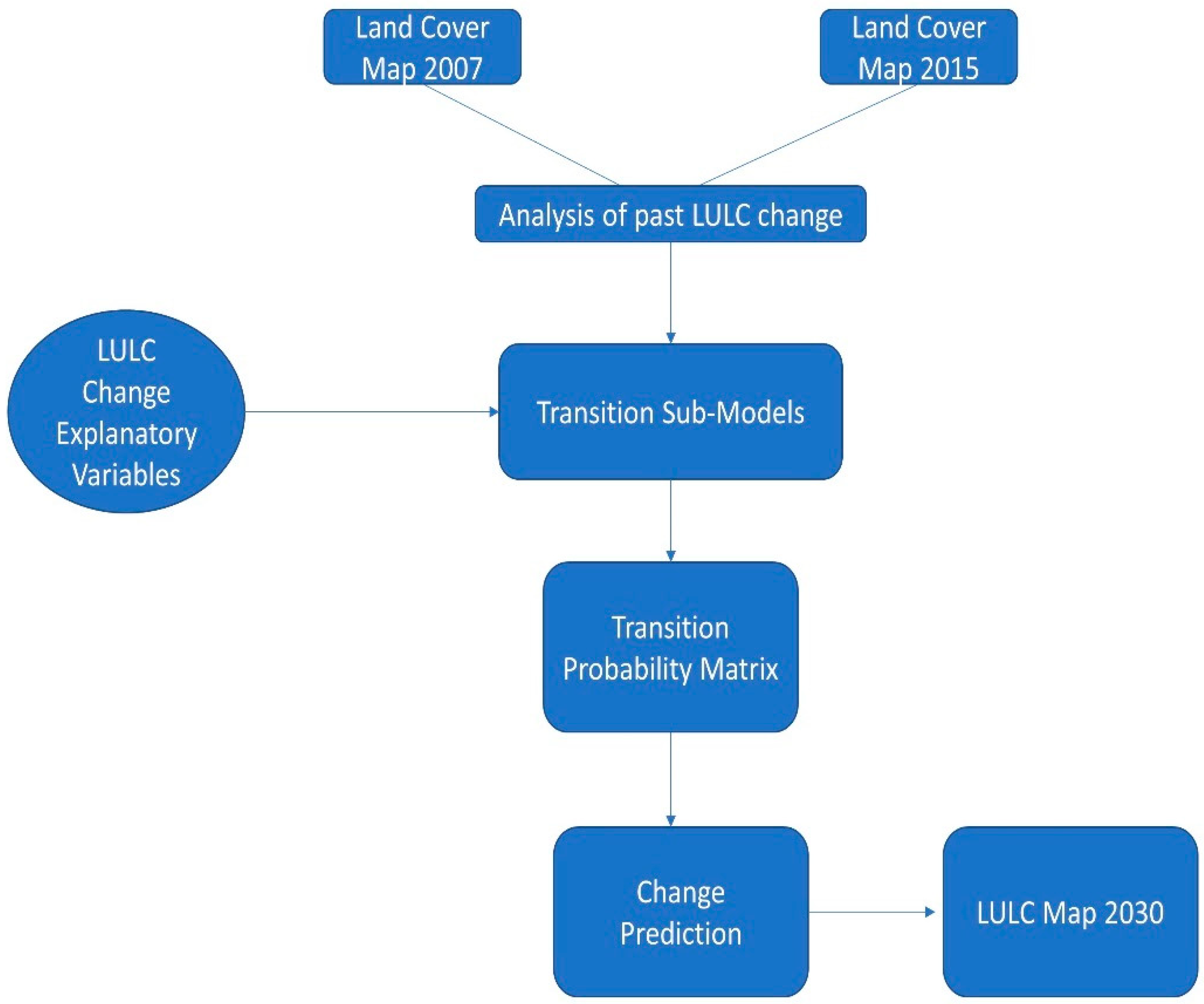
2.1. Outline of the LULC Change Methodology
2.2. Analysis of Past Change
2.3. Explanatory Variable Selection
2.4. Transition Sub-Models and Change Demand Modelling
2.5. Landscape Scenario Storylines
2.5.1. Business-as-Usual Scenario (B-a-U)
2.5.2. Green Future (GF)
2.5.3. Free Trade Agreement (FTA)
2.5.4. World Trade Organisation (FTA)
2.5.5. Unilateral Trade Liberalisation
2.6. Determining Transition Probability Matrices for Future Scenarios
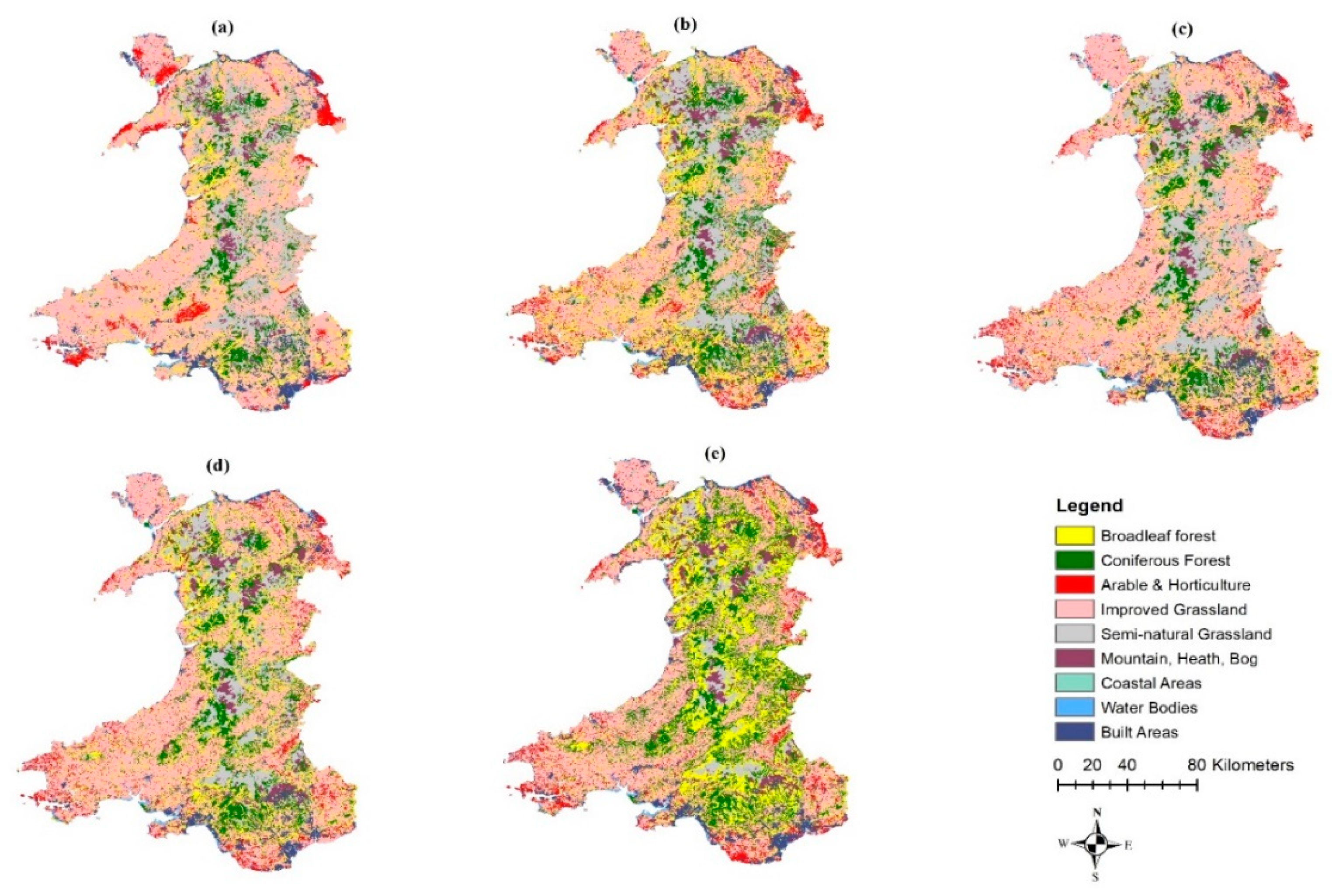
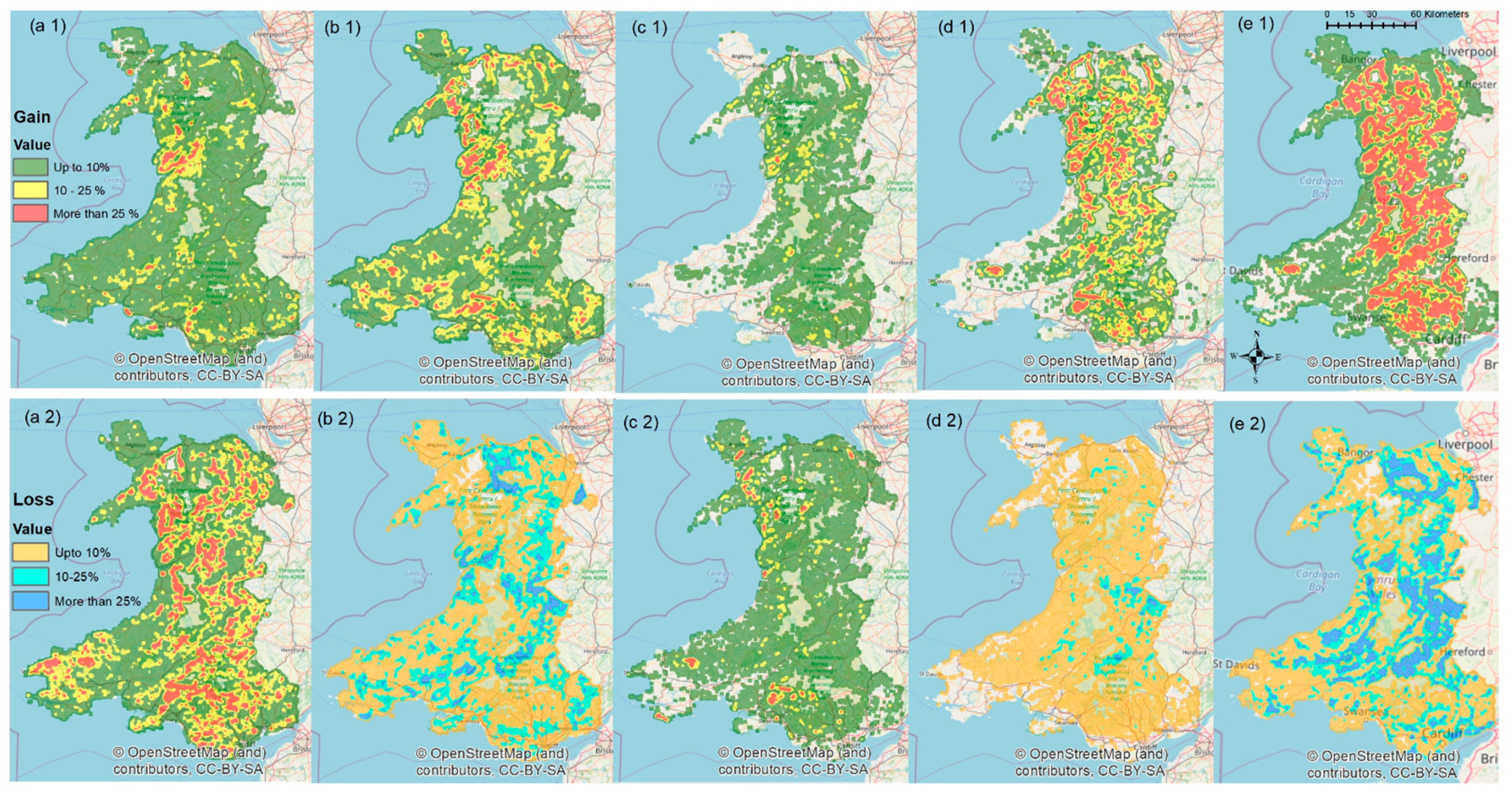
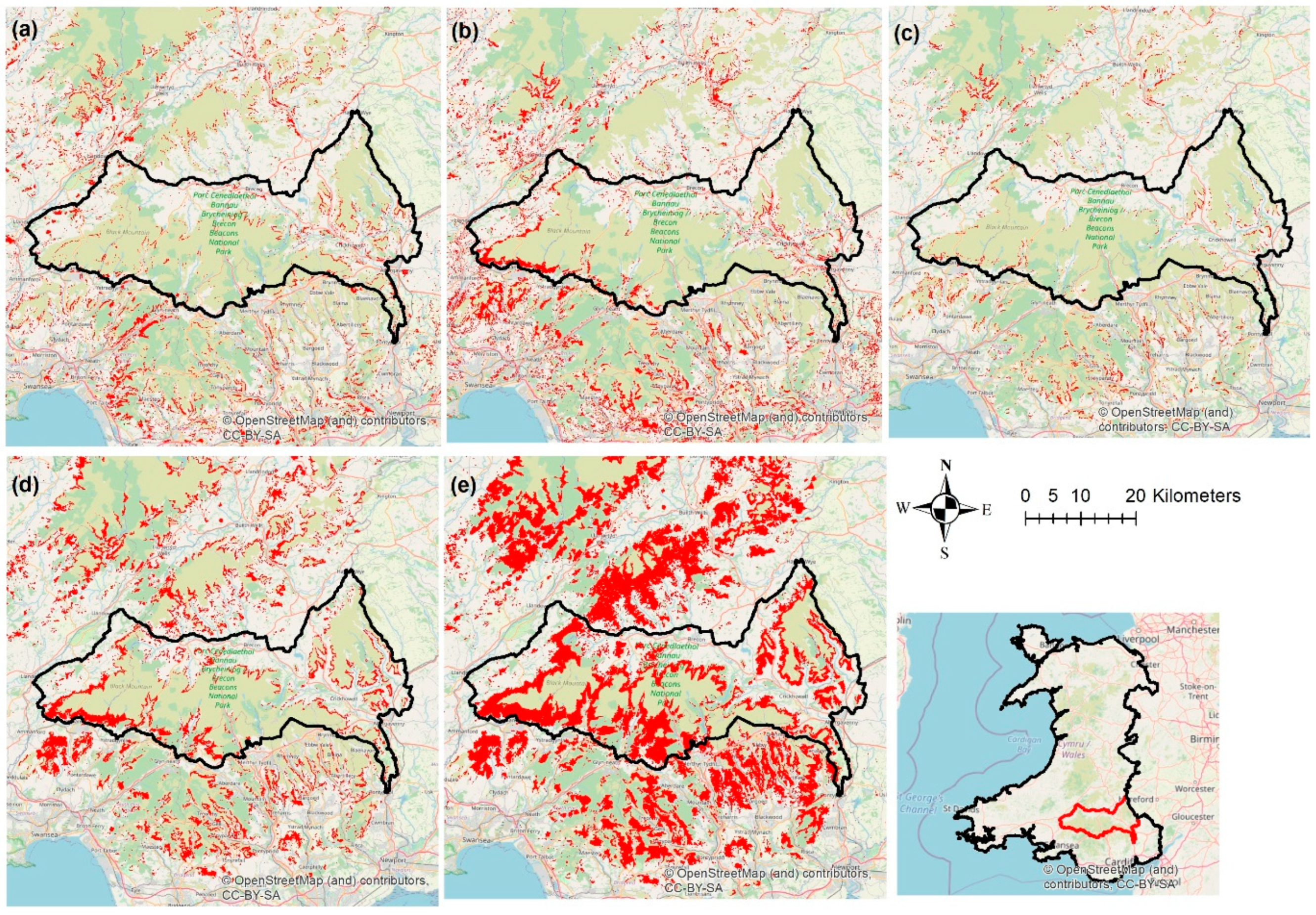
3. Results
4. Discussion
5. Conclusions
Supplementary Materials
Author Contributions
Funding
Institutional Review Board Statement
Informed Consent Statement
Data Availability Statement
Acknowledgments
Conflicts of Interest
References
- Whitehouse, N.J.; Smith, D. How fragmented was the British Holocene wildwood? Perspectives on the “Vera” grazing debate from the fossil beetle record. Quat. Sci. Rev. 2010, 29, 539–553. [Google Scholar] [CrossRef]
- DellaSala, D.A.; Alaback, P.; Drescher, A.; Holien, H.; Spribille, T.; Ronnenberg, K. Temperate and Boreal Rainforest Relicts of Europe. In Temperate and Boreal Rainforests of the World: Ecology and Conservation; Island Press/Center for Resource Economics: Washington, DC, USA, 2011; pp. 154–180. ISBN 978-1-61091-008-8. [Google Scholar]
- Forestry Commission. Forestry Statistics 2019; Forestry Commission: Edinburgh, UK, 2019. [Google Scholar]
- Stevenson, A.C.; Thompson, D.B.A. Long-term changes in the extent of heather moorland in upland Britain and Ireland: Palaeoecological evidence for the importance of grazing. Holocene 1993, 3, 70–76. [Google Scholar] [CrossRef]
- Spencer, J.W.; Kirby, K.J. An inventory of ancient woodland for England and Wales. Biol. Conserv. 1992, 62, 77–93. [Google Scholar] [CrossRef]
- Smart, S.M.; Bunce, R.G.H.; Marrs, R.; LeDuc, M.; Firbank, L.G.; Maskell, L.C.; Scott, W.A.; Thompson, K.; Walker, K.J. Large-scale changes in the abundance of common higher plant species across Britain between 1978, 1990 and 1998 as a consequence of human activity: Tests of hypothesised changes in trait representation. Biol. Conserv. 2005, 124, 355–371. [Google Scholar] [CrossRef]
- Hopkins, A.; Wainwright, J. Changes in botanical composition and agricultural management of enclosed grassland in upland areas of England and Wales, 1970–1986, and some conservation implications. Biol. Conserv. 1989, 47, 219–235. [Google Scholar] [CrossRef]
- Ceballos, G.; Ehrlich, P.R. Mammal population losses and the extinction crisis. Science 2002, 296, 904–907. [Google Scholar] [CrossRef] [PubMed]
- Butler, S.J.; Vickery, J.A.; Norris, K. Farmland Biodiversity and the Footprint of Agriculture. Science 2007, 315, 381–385. [Google Scholar] [CrossRef]
- Benton, T.G.; Bryant, D.M.; Cole, L.; Crick, H.Q.P. Linking agricultural practice to insect and bird populations: A historical study over three decades. J. Appl. Ecol. 2002, 39, 673–687. [Google Scholar] [CrossRef]
- Chamberlain, D.E.; Fuller, R.J. Local extinctions and changes in species richness of lowland farmland birds in England and Wales in relation to recent changes in agricultural land-use. Agric. Ecosyst. Environ. 2000, 78, 1–17. [Google Scholar] [CrossRef]
- Simoncini, R.; Ring, I.; Sandström, C.; Albert, C.; Kasymov, U.; Arlettaz, R. Constraints and opportunities for mainstreaming biodiversity and ecosystem services in the EU’s Common Agricultural Policy: Insights from the IPBES assessment for Europe and Central Asia. Land Use Policy 2019, 88, 104099. [Google Scholar] [CrossRef]
- Loth, A.F.; Newton, A.C. Rewilding as a restoration strategy for lowland agricultural landscapes: Stakeholder-assisted multi-criteria analysis in Dorset, UK. J. Nat. Conserv. 2018, 46, 110–120. [Google Scholar] [CrossRef]
- Forgrave, A. Farming anger forces Rewilding Britain to pull out of Summit To Sea project in Mid Wales. Dailypost 2019, 1, 117. [Google Scholar]
- Welsh Government. Brexit and Our Land: Securing the Future of Welsh Farming—Consultation Overview; Land Management Reform Division: Cardiff, UK, 2018; ISBN 9781789374834.
- Welsh Government. Brexit and Our Land: Securing the Future of Welsh Farming—Our Response; Land Management Reform Division: Cardiff, UK, 2018; pp. 1–14.
- Hart, K.; Baldock, D. The Emerging Agricultural Policy Frameworks in the Four UK Administrations A Briefing for the UK Land Use Policy Group; Institute for European Environmental Policy: Glasgow, UK, 2019. [Google Scholar]
- Tsouvalis, J.; Little, R. Agriculture Bill: Here’s what it means for farming and the environment after Brexit. Conversat. UK 2020, 21, 133. [Google Scholar]
- Coe, S.; Ward, M. Brexit: Trade Issue for Food and Agriculture; Commons Library Briefing: London, UK, 2019. [Google Scholar]
- Yanhui, W.; Bonell, M.; Feger, K.-H.; Pengtao, Y.; Wei, X.; Lihong, X. Changing Forestry Policy by Integrating Water Aspects into Forest/Vegetation Restoration in Dryland Areas in China. Bull. Chin. Acad. Sci. Agric. Water Ecol. Bull. Chin. Acad. Sci. BCAS 2012, 2626, 59–67. [Google Scholar]
- Chappell, N.A. “Forests and floods: Moving to an evidence-based approach to watershed and integrated flood management” by Ian R. Calder (UK) and Bruce Aylward (USA). Water Int. 2006, 31, 541–543. [Google Scholar] [CrossRef]
- Manzoor, S.A.; Griffiths, G.; Latham, J.; Lukac, M. Scenario-led modelling of broadleaf forest expansion in Wales. R. Soc. Open Sci. 2019, 6, 190026. [Google Scholar] [CrossRef]
- Kamusoko, C.; Wada, Y.; Furuya, T.; Tomimura, S.; Nasu, M.; Homsysavath, K. Simulating Future Forest Cover Changes in Pakxeng District, Lao People’s Democratic Republic (PDR): Implications for Sustainable Forest Management. Land 2013, 2, 1–19. [Google Scholar] [CrossRef]
- Soares-Filho, B.S.; Nepstad, D.C.; Curran, L.M.; Cerqueira, G.C.; Garcia, R.A.; Ramos, C.A.; Voll, E.; McDonald, A.; Lefebvre, P.; Schlesinger, P. Modelling conservation in the Amazon basin. Nature 2006, 440, 520–523. [Google Scholar] [CrossRef]
- Koomen, E.; Koekoek, A.; Dijk, E. Simulating Land-use Change in a Regional Planning Context. Appl. Spat. Anal. Policy 2011, 4, 223–247. [Google Scholar] [CrossRef]
- Bounyang, V. Forestry Strategy to the Year 2020. Vientiane Lao PDR 2005, 1, 1–89. [Google Scholar]
- Buenemann, M.; Martius, C.; Jones, J.W.; Herrmann, S.M.; Klein, D.; Mulligan, M.; Reed, M.S.; Winslow, M.; Washington-Allen, R.A.; Lal, R.; et al. Integrative geospatial approaches for the comprehensive monitoring and assessment of land management sustainability: Rationale, Potentials, and Characteristics. L. Degrad. Dev. 2011, 22, 226–239. [Google Scholar] [CrossRef]
- Mishra, V.N.; Rai, P.K. A remote sensing aided multi-layer perceptron-Markov chain analysis for land use and land cover change prediction in Patna district (Bihar), India. Arab. J. Geosci. 2016, 9, 249. [Google Scholar] [CrossRef]
- Zhang, Q.; Ban, Y.; Liu, J.; Hu, Y. Simulation and analysis of urban growth scenarios for the Greater Shanghai Area, China. Comput. Environ. Urban Syst. 2011, 35, 126–139. [Google Scholar] [CrossRef]
- Ahmed, B.; Ahmed, R. Modeling Urban Land Cover Growth Dynamics Using Multi-Temporal Satellite Images: A Case Study of Dhaka, Bangladesh. ISPRS Int. J. Geo-Inf. 2012, 1, 3–31. [Google Scholar] [CrossRef]
- Ozturk, D. Urban growth simulation of Atakum (Samsun, Turkey) using cellular automata-Markov chain and Multi-layer Perceptron-Markov chain models. Remote Sens. 2015, 7, 5918–5950. [Google Scholar] [CrossRef]
- Office for National Statistics. Statistical Bulletin: Annual Mid Year Population Estimates: 2013; Office for National Statistics: London, UK, 2014.
- Swetnam, R.D.; Tweed, F.S. A tale of two landscapes: Transferring landscape quality metrics from Wales to Iceland. Land Use Policy 2018, 76, 565–576. [Google Scholar] [CrossRef]
- Forestry Commission. Chapter 1: Woodland Areas and Planting. For. Stat. 2017, 2017, 37. [Google Scholar]
- Welsh Government. Research Service Natural Resources Wales Forestry in Wales Quick Guide. For. Comm. For. Stat. 2013, 1, 1–5. [Google Scholar]
- Park, C.; Park, T. Review of Land Use Climate Change. An Assessment of the Evidence Base for Climate Change Action in the Agriculture, Land Use and Wider Foodchain Sectors in Wales; ADA UK Ltd.: Cardiff, UK, 2014. [Google Scholar]
- Clark Labs. TerrSet Tutorial; Clark Labs, Clark University: Worcester, MA, USA, 2015. [Google Scholar]
- Morton, D.; Rowland, C.; Wood, C.; Meek, L.; Marston, C.; Smith, G.; Wadsworth, R.; Simpson, I.C. Countryside Survey: Final Report for LCM2007—The New UK Land Cover Map. Countryside Survey Technical Report No 11/07. (CEH Project Number: C03259). 2011. Available online: https://www.ceh.ac.uk/sites/default/files/LCM2007%20Final%20Report.pdf (accessed on 24 November 2020).
- Building, M.; Lane, B.; Gifford, C.; Kingdom, U. Land Cover Map 2015 (25 m Raster, GB); Center for Ecology and Hydrology: Oxfordshire, UK, 2017; Volume 44, pp. 1–25. [Google Scholar]
- Verburg, P.H.; Schot, P.P.; Dijst, M.J.; Veldkamp, A. Land use change modelling: Current practice and research priorities. GeoJournal 2004, 61, 309–324. [Google Scholar] [CrossRef]
- Dadhich, P.N.; Hanaoka, S. Markov Method Integration with Multi-layer Perceptron Classifier for Simulation of Urban Growth of Jaipur City. In Proceedings of the 6th Wseas International Conference on Remote Sensing (Remote ‘10), Iwate Prefectural University, Takizawa, Japan, 4–6 October 2010; pp. 118–123. [Google Scholar]
- Iizuka, K.; Johnson, B.A.; Onishi, A.; Magcale-Macandog, D.B.; Endo, I.; Bragais, M. Modeling Future Urban Sprawl and Landscape Change in the Laguna de Bay Area, Philippines. Land 2017, 6, 26. [Google Scholar] [CrossRef]
- DasGupta, R.; Hashimoto, S.; Okuro, T.; Basu, M. Scenario-based land change modelling in the Indian Sundarban delta: An exploratory analysis of plausible alternative regional futures. Sustain. Sci. 2019, 14, 221–240. [Google Scholar] [CrossRef]
- Manzoor, S.A.; Griffiths, G.; Lukac, M. Species distribution model transferability and model grain size—Finer may not always be better. Sci. Rep. 2018, 8, 1–9. [Google Scholar] [CrossRef] [PubMed]
- Hashimoto, S.; DasGupta, R.; Kabaya, K.; Matsui, T.; Haga, C.; Saito, O.; Takeuchi, K. Scenario analysis of land-use and ecosystem services of social-ecological landscapes: Implications of alternative development pathways under declining population in the Noto Peninsula, Japan. Sustain. Sci. 2019, 14, 53–75. [Google Scholar] [CrossRef]
- Verburg, P.H.; van Berkel, D.B.; van Doorn, A.M.; van Eupen, M.; van den Heiligenberg, H.A.R.M. Trajectories of land use change in Europe: A model-based exploration of rural futures. Landsc. Ecol. 2010, 25, 217–232. [Google Scholar] [CrossRef]
- Hubbard, C.; Davis, J.; Feng, S.; Harvey, D.; Liddon, A.; Moxey, A.; Ojo, M.; Patton, M.; Philippidis, G.; Scott, C.; et al. Brexit: How Will UK Agriculture Fare? EuroChoices 2018, 17, 19–26. [Google Scholar] [CrossRef]
- Owen, J.; Stojanovic, A.; Rutter, J. Trade after Brexit: Option for the UK’s Relationship with the EU; Institute for Government: London, UK, 2017.
- Clark Labs. TerrSet Geospatial Monitoring and Modeling Software; Clark Labs, Clark University: Worcester, MA, USA, 2015. [Google Scholar]
- Symes, D.; Phillipson, J. ’A sea of troubles’ (2): Brexit and the UK seafood supply chain. Mar. Policy 2019, 102, 5–9. [Google Scholar] [CrossRef]
- Terres, J.M.; Scacchiafichi, L.N.; Wania, A.; Ambar, M.; Anguiano, E.; Buckwell, A.; Coppola, A.; Gocht, A.; Källström, H.N.; Pointereau, P.; et al. Farmland abandonment in Europe: Identification of drivers and indicators, and development of a composite indicator of risk. Land Use Policy 2015, 49, 20–34. [Google Scholar] [CrossRef]
- Forney, J. Blind spots in agri-environmental governance: Some reflections and suggestions from Switzerland. Rev. Agric. Food Environ. Stud. 2016, 97, 1–13. [Google Scholar] [CrossRef]
- Thompson, D.B.A.; MacDonald, A.J.; Marsden, J.H.; Galbraith, C.A. Upland heather moorland in Great Britain: A review of international importance, vegetation change and some objectives for nature conservation. Biol. Conserv. 1995, 71, 163–178. [Google Scholar] [CrossRef]
- Wilkinson, D. Defending British Farming Standards in Post-Brexit Trade Negotiations. EuroChoices 2020, 19, 4–10. [Google Scholar] [CrossRef]
- Lasanta, T.; Arnáez, J.; Pascual, N.; Ruiz-Flaño, P.; Errea, M.P.; Lana-Renault, N. Space–time process and drivers of land abandonment in Europe. Catena 2017, 149, 810–823. [Google Scholar] [CrossRef]
- Kolecka, N.; Kozak, J.; Kaim, D.; Dobosz, M.; Ostafin, K.; Ostapowicz, K.; Wężyk, P.; Price, B. Understanding farmland abandonment in the Polish Carpathians. Appl. Geogr. 2017, 88, 62–72. [Google Scholar] [CrossRef]
- Pereira, H.M.; Navarro, L.M. Rewilding European Landscapes; Springer International Publishing: New York, NY, USA, 2015. [Google Scholar]
- Beilin, R.; Lindborg, R.; Stenseke, M.; Pereira, H.M.; Llausàs, A.; Slätmo, E.; Cerqueira, Y.; Navarro, L.; Rodrigues, P.; Reichelt, N.; et al. Analysing how drivers of agricultural land abandonment affect biodiversity and cultural landscapes using case studies from Scandinavia, Iberia and Oceania. Land Use Policy 2014, 36, 60–72. [Google Scholar] [CrossRef]
- Linhart, Y.B.; Wheland, R.J. Woodland Regeneration in Relation to Grazing and Fencing in Coed Gorswen, North Wales. J. Appl. Ecol. 1980, 17, 827–840. [Google Scholar] [CrossRef]


| Category (I) | Variables (II) | Selection Thresholds (III) Cramer’s V (>0.15) & Correlation (<0.75) | Source |
|---|---|---|---|
| Topography & Soil | Altitude | 0.3239 | Shuttle Radar Topography Mission (SRTM), www.usgs.gov |
| Aspect | 0.165 | Shuttle Radar Topography Mission (SRTM), www.usgs.gov | |
| Slope | 0.1504 | Shuttle Radar Topography Mission (SRTM), www.usgs.gov | |
| Hillshade | 0.02 | Shuttle Radar Topography Mission (SRTM), www.usgs.gov | |
| Soil Carbon Content | 0.06 | ISRIC World Soil Information, www.isric.org | |
| Proximity | Distance from Broadleaf Forest | 0.191 | TerrSet Software, https://clarklabs.org/terrset/ |
| Distance from Conifer Forest | 0.167 | TerrSet Software, https://clarklabs.org/terrset/ | |
| Distance from Arable & Horticulture | 0.154 | TerrSet Software, https://clarklabs.org/terrset/ | |
| Distance from Improved Grassland | 0.154 | TerrSet Software, https://clarklabs.org/terrset/ | |
| Distance from Semi-natural Grassland | 0.165 | TerrSet Software, https://clarklabs.org/terrset/ | |
| Distance from Mountain, Heath, Bog | 0.21 | TerrSet Software, https://clarklabs.org/terrset/ | |
| Distance from Urban Areas | 0.2 | TerrSet Software, https://clarklabs.org/terrset/ | |
| Distance from Water Bodies | 0.182 | TerrSet Software, https://clarklabs.org/terrset/ | |
| Distance from Access Points | 0 | https://digimap.edina.ac.uk/ | |
| Distance from Green Spaces | 0 | https://digimap.edina.ac.uk/ | |
| Distance from Motorways | 0 | https://digimap.edina.ac.uk/ | |
| Distance from Road Links | 0.151 | https://digimap.edina.ac.uk/ | |
| Distance from Hydro-nodes | 0 | https://digimap.edina.ac.uk/ | |
| Distance from National Parks | 0.03 | https://digimap.edina.ac.uk/ | |
| Socioeconomic | Population Density | 0.1763 | National Centers for Environmental Information, www.ngdc.noaa.gov/eog |
| Night Lights | 0.04 | National Centers for Environmental Information, www.ngdc.noaa.gov/eog | |
| Evidence Likelihood | Arable to Built | 0.1 | TerrSet Software, https://clarklabs.org/terrset/ |
| Arable to Improved | 0.151 | TerrSet Software, https://clarklabs.org/terrset/ | |
| Conifer to Broad | 0.2647 | TerrSet Software, https://clarklabs.org/terrset/ | |
| Mountain, Heath, Bog to Semi-natural grassland | 0.1849 | TerrSet Software, https://clarklabs.org/terrset/ | |
| Semi-natural grassland to Arable | 0.1647 | TerrSet Software, https://clarklabs.org/terrset/ | |
| Semi-natural grassland to Broad | 0.17 | TerrSet Software, https://clarklabs.org/terrset/ | |
| Semi-natural grassland to Built areas | 0.17 | TerrSet Software, https://clarklabs.org/terrset/ | |
| Semi-natural grassland to Improved grassland | 0.17 | TerrSet Software, https://clarklabs.org/terrset/ |
| 2030 | |||||||
|---|---|---|---|---|---|---|---|
| 2007 | 2015 | B-a-U | GF | FTA | WTO | UTL | |
| Broadleaf forest | 124.5 | 165 | 200.2 [+21] | 330 [+110] | 199.7 [+21] | 313.5 [+90] | 478.6 [+190] |
| Coniferous Forest | 143 | 161 | 190.3 [+18] | 241.6 [+50] | 190 [+18] | 231.9 [+44] | 359.3 [+19] |
| Arable & Horticulture | 176.6 | 99.5 | 92.9 [−7] | 109.4 [+10] | 92.5 [−7] | 99.5 [0] | 114.5 [+15] |
| Improved Grassland | 841.3 | 983.4 | 1045.7 [+6] | 792.7 [−19] | 1042.4 [+6] | 934.3 [−5] | 721.8 [−27] |
| Semi-natural Grassland | 510.9 | 428.9 | 314.4 [−27] | 317.4 [−26] | 292 [−32] | 212.1 [−51] | 107.2 [−75] |
| Mountain, Heath, Bog | 163.9 | 98.1 | 45.8 [−53] | 98.1 [0] | 72.6 [−26] | 98.1 [0] | 107.9 [+10] |
| Water Bodies | 12.9 | 12.1 | 12.1 [0] | 12.1 [0] | 12.1 [0] | 12.1 [0] | 12.1 [0] |
| Coastal Areas | 16.1 | 25.1 | 25.1 [0] | 25.1 [0] | 25.1 [0] | 25.1 [0] | 25.1 [0] |
| Built Areas | 88.5 | 105 | 151.8 [+44] | 151.8 [+44] | 151.8 [+45] | 151.7 [+44] | 151.7 [+44] |
| To: | Broadleaf Forest | Conifer Forest | Arable | Improved Grassland | Semi-Natural Grassland | Mountain, Heath, Bog | Water Bodies | Coastal Areas | Built Areas | |
|---|---|---|---|---|---|---|---|---|---|---|
| From: | ||||||||||
| Broadleaf Forest | 0.5341 | 0.1349 | 0.0185 | 0.1822 | 0.0594 | 0.0133 | 0.0033 | 0.0102 | 0.0441 | |
| Coniferous Forest | 0.1848 | 0.748 | 0.0035 | 0.0289 | 0.02 | 0.0041 | 0.0019 | 0.0017 | 0.007 | |
| Arable & Horticulture | 0.05 | 0.0094 | 0.0896 | 0.692 | 0.074 | 0.0078 | 0.0019 | 0.0103 | 0.0652 | |
| Improved Grassland | 0.0394 | 0.0079 | 0.0556 | 0.762 | 0.1004 | 0.0062 | 0.0006 | 0.0052 | 0.0227 | |
| Semi-natural Grassland | 0.0706 | 0.0477 | 0.0328 | 0.3955 | 0.3652 | 0.0495 | 0.0013 | 0.0126 | 0.0248 | |
| Mountain, Heath & Bog | 0.0595 | 0.0869 | 0.0187 | 0.1626 | 0.4409 | 0.2063 | 0.0024 | 0.0078 | 0.015 | |
| Water Bodies | 0.0658 | 0.0158 | 0.0128 | 0.0511 | 0.0441 | 0.0141 | 0.6068 | 0.1557 | 0.0338 | |
| Coastal Areas | 0.0161 | 0.0029 | 0.0204 | 0.0654 | 0.041 | 0.0047 | 0.0592 | 0.7439 | 0.0463 | |
| Built Areas | 0.077 | 0.017 | 0.0249 | 0.112 | 0.0342 | 0.019 | 0.0035 | 0.0202 | 0.6921 | |
Publisher’s Note: MDPI stays neutral with regard to jurisdictional claims in published maps and institutional affiliations. |
© 2021 by the authors. Licensee MDPI, Basel, Switzerland. This article is an open access article distributed under the terms and conditions of the Creative Commons Attribution (CC BY) license (http://creativecommons.org/licenses/by/4.0/).
Share and Cite
Manzoor, S.A.; Griffiths, G.; Christian Rose, D.; Lukac, M. The Return of Wooded Landscapes in Wales: An Exploration of Possible Post-Brexit Futures. Land 2021, 10, 59. https://doi.org/10.3390/land10010059
Manzoor SA, Griffiths G, Christian Rose D, Lukac M. The Return of Wooded Landscapes in Wales: An Exploration of Possible Post-Brexit Futures. Land. 2021; 10(1):59. https://doi.org/10.3390/land10010059
Chicago/Turabian StyleManzoor, Syed Amir, Geoffrey Griffiths, David Christian Rose, and Martin Lukac. 2021. "The Return of Wooded Landscapes in Wales: An Exploration of Possible Post-Brexit Futures" Land 10, no. 1: 59. https://doi.org/10.3390/land10010059
APA StyleManzoor, S. A., Griffiths, G., Christian Rose, D., & Lukac, M. (2021). The Return of Wooded Landscapes in Wales: An Exploration of Possible Post-Brexit Futures. Land, 10(1), 59. https://doi.org/10.3390/land10010059


