The Legal Element of Fixing the Boundary for Indonesian Complete Cadastre


Abstract
1. Introduction
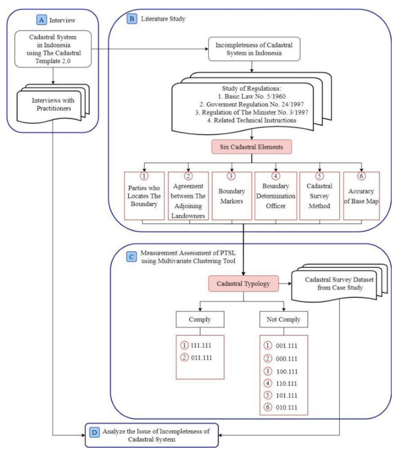
2. Materials and Methods
2.1. Materials
2.2. Methods
2.3. Assessment of Compliance
3. Results
3.1. Cadastral System in Indonesia
3.2. The Fixed Boundaries
3.3. Cadastral Typologies
- Parties that locate the boundary (1), agreement between the adjoining landowners (1), boundary markers (1).
- Parties who locate the boundary (0), agreement between the adjoining landowners (1), boundary markers (1).
- Parties who locate the boundary (0), agreement between the adjoining landowners (0), boundary markers (1).
- Parties who locate the boundary (0), agreement between the adjoining landowners (0), boundary markers (0).
- Parties who locate the boundary (1), agreement between the adjoining landowners (0), boundary markers (0).
- Parties who locate the boundary (1), agreement between the adjoining landowners (1), boundary markers (0).
- Parties who locate the boundary (1), agreement between the adjoining landowners (0), boundary markers (1).
- Parties who locate the boundary (0), agreement between the adjoining landowners (1), boundary markers (0).
3.4. Assessment of Compliance
3.4.1. The Participation of Eligible Landowners
- Landholders feel safe, they do not directly locate the boundaries of their parcels. They trust both the local and land officers and based on the interview that was carried out, and it shows that fixed boundary concerning the exact coordinate is unimportant to them.
- The compulsory obligations stipulated in the regulations were not perceived as such by the right-holders. On the contrary, the obligatory enforcement was also not carried out, and the right holders who did not certify their land even at the systematic registration were not sanctioned.
- The parties must be eligible to locate the boundary and need to carry out such an act before ascertaining the truth through the procedure of determining the rights of the landowner. This logical sequence is important for the purposes of the land information system, which needs to be completed before accepting the general boundary. However, this assumes the boundary determination is based on agreements that are not between the actual owners, and rather, are between people that occupy or use the land, therefore making the legal basis of the agreement invalid.
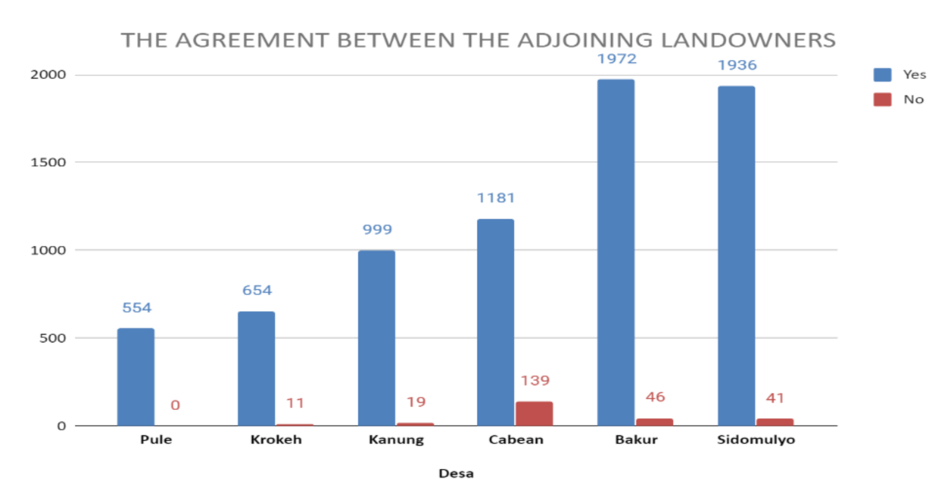
3.4.2. The Agreement between the Adjoining Landowners
- The boundary agreement does not significantly impede land registration.
- Only a few of them (3.39%) stated that they have not obtained boundary consensus. Based on the interview with landowners and local officer, they reported that boundary disputes are relatively rare. Most respondents stated that it is difficult to obtain approval from landowners that do not reside on the site.
- A total of 496 (6.57%) parcels signed agreements without proper boundary markers or even lacked boundaries.
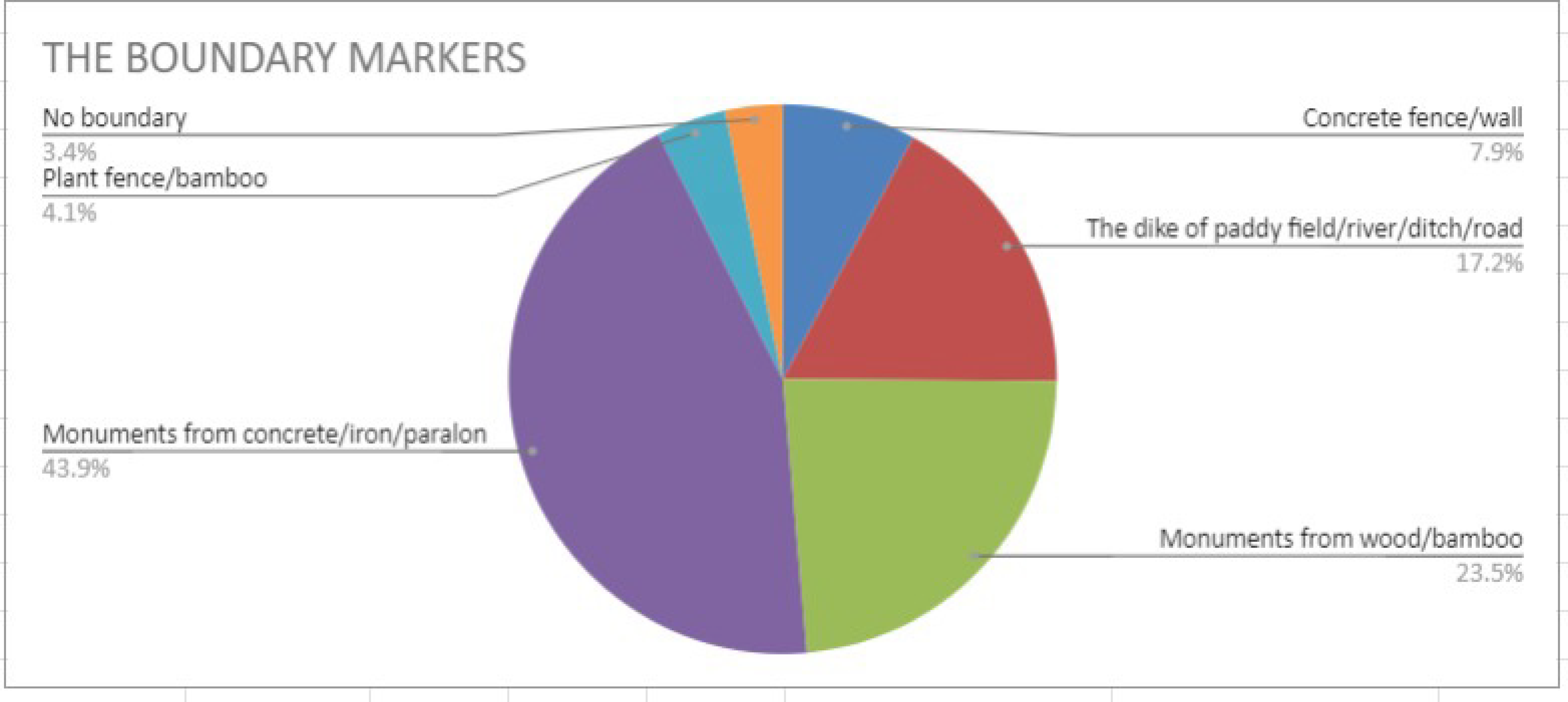
3.4.3. The Boundary Markers
3.4.4. The Compliance of Cadastre Elements
4. Discussion
5. Conclusions
6. Recommendation
Author Contributions
Funding
Acknowledgments
Conflicts of Interest
Appendix A

| Country Context | Statement |
|---|---|
| Purpose of Cadastral System | The cadastral system’s primary purpose is to support the registration of land by providing legal security rights and facilitating the transfer of rights in the land tenure function. |
| Types of Cadastral System | Different institutions administer other cadastral systems to register forest area, fiscal cadastre, more discrete rights and responsibilities, such as mining rights and concessions, to carry out land activities. These cadastral systems generally use different systems for base data. |
| Cadastral Concept | The principal cadastral unit is a surveyed and boundary marked parcel, with spatial data, such as location, boundaries, and an area. The fixed boundary is mandatory. Nomor Identifikasi Bidang (NIB) is a parcel consisting of 13 digits, the first eight digits are the code of the province, district, sub-district, and kelurahan/village where it is located, and the last five digits are the parcel number. The administration area code is determined through the ministerial decree. The title rights unit is issued in accordance with the parcels defined in the survey system. Three distinct categories of land rights were registered, namely (a) the three real property rights specified in the Undang-Undang Pokok Agraria (UUPA), i.e., ownership right (hak milik), the right to build (hak guna bangunan), and the right of exploitation (hak guna usaha), (b) the pre-1960 land rights on former “western” and “Indonesian” land that has been “converted” to one of the three UUPA rights mentioned above, and (c) three additional types of land rights introduced after enactment of the UUPA, i.e., the right of use on state land (hak pakai), the “development right” (hak pengelolaan), and the strata title (hak milik atas satuan rumah susun). Properties differ from parcels and titles. The term “property” is used for administration and taxation purposes. |
| Content of Cadastral System | The principal cadastral components are spatial and legal data. To present these data, the land office organizes the public registers (daftar umum) consisting of registration maps (peta pendaftaran), land registers (daftar tanah), surveying letters (surat ukur), land books (buku tanah), and name lists (daftar nama). Warkah is defined as the documents used as evidentiary tools, and the basis for registration with identification kept as an integral part of the daftar umum. The daftar umum, in particular, buku tanah is a comprehensive and functional electronic database for checking all encumbrances, caveats, charges, or privileges affecting a registered property’s encumbrances. Land offices maintain a hardcopy of peta pendaftaran, some of which are already in fully digital and stored at the Komputerisasi Kegiatan Pertanahan (KKP) system. Peta pendaftaran roles as a geographic information system (a fully digital geographic representation of the land plot)—an electronic database for recording boundaries, checking plans, and providing cadastral information on land ownership and maps, which are kept in a single database. Both the buku tanah and the peta pendaftaran use the same NIB as an identifier number to describe the same parcel. Information is accessed by mentioning the NIB, or land rights number (nomor hak), or based on the landmark on the peta pendaftaran, or the name of the right-holder, and not through the address. |
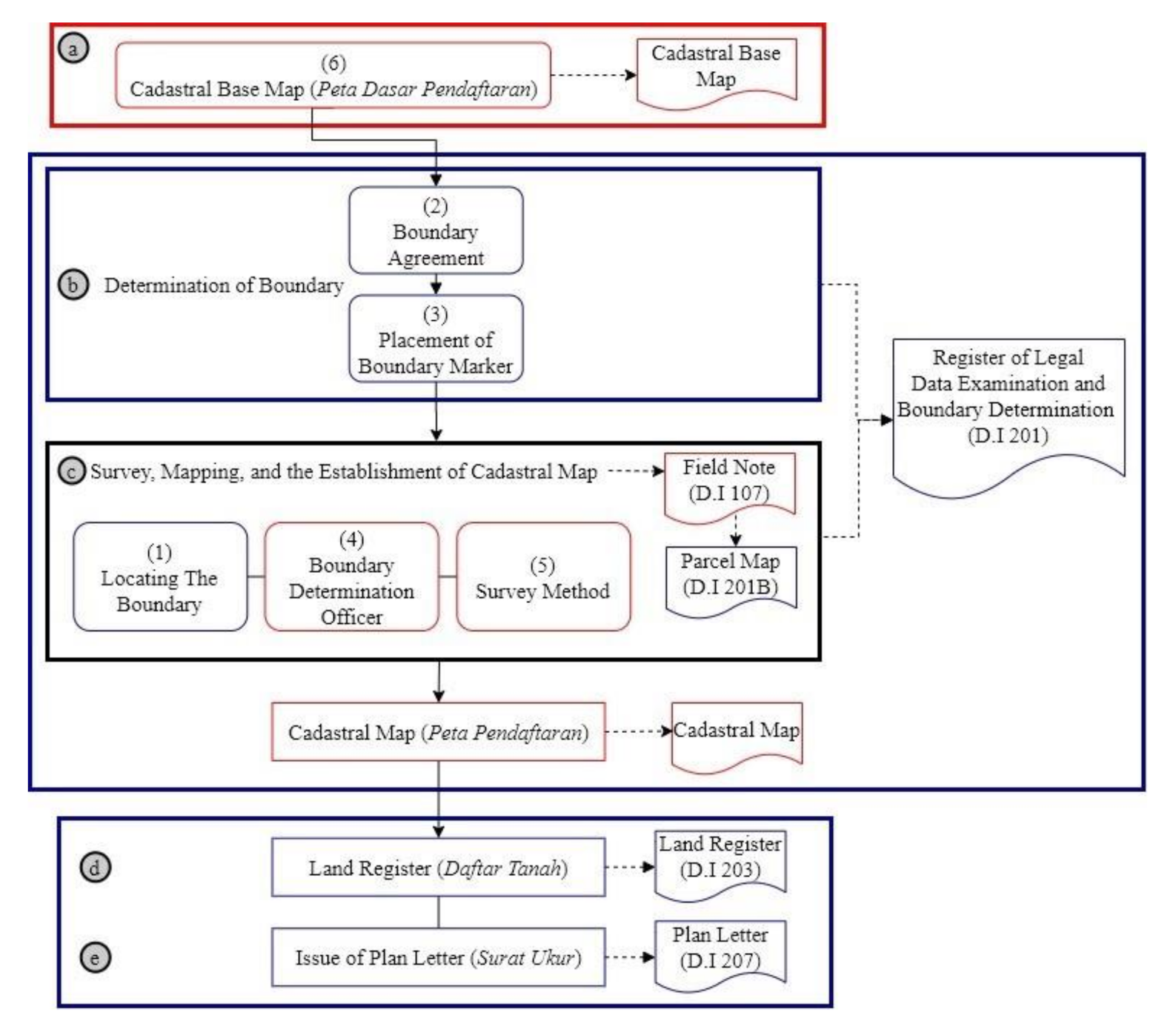
| Cadastral Map | Cadastral map in the form of peta pendaftaran illustrates the parcels of land for the purposes of recording/bookkeeping. It contains information on the shape, boundary, location, and NIB, as well as the existence of buildings when necessary. The parcel is the smallest unit surveyed and registered in the peta pendaftaran. The fixed boundary is mandatory. It is accomplished by boundary determination procedures stipulated in the regulation, which means that there needs to be an eligible landowner to locate the boundary markers, agreements between the adjoining landowners, determination officer, cadastral survey methods, and accuracy of the base map. The activity of fixing boundaries is not part of the technical exercise of surveying and mapping, rather it is legal. Peta pendaftaran is based on the cadastral base map—peta dasar pendaftaran—which is a map that contains technical base points and geographical elements, such as rivers, roads, buildings, and spatial boundaries of parcels. The peta dasar pendaftaran has a scale of 1: 1,000 or higher for urban areas, 1: 2,500 or higher for agricultural areas, and 1: 10,000 or smaller for large plantation areas. Planimetric accuracy is determined to be higher or equal to 0.3 mm on the map scale. The national coordinate system uses the Transverse Mercator projection with a zone width of 3 ° (three degrees) called TM-3. ° The central meridian zone TM-3 ° is located 1.5 ° (one point five degrees) to the east and west of the central meridian of the concerned UTM zone. The scale factor magnitude in the central meridian (k) used is 0.9999. Pseudo zero points used are east (x) = 200,000 m, and north (y) = 1,500,000 m. Earth’s mathematical model as a reference field is a spheroid in the WGS-1984 datum with parameters a = 6,378,137 m and f = 1 / 29,825,722,357. |
| Example of a Cadastral Map | Peta pendaftaran can be seen at https://bhumi.atrbpn.go.id/ Peta pendaftaran comprises an incomplete thematic layer, such as spatial planning and overlaid land value zone map, that cannot be seamlessly interoperable. The role of peta pendaftaran is still limited to land tenure function services. The integration of the Land Information System at the national, provincial, or district/city level, and its role for other thematic mappings, are still discouraging. |
| Role of Cadastral Layer in SDI | The cadastral layer has not been integrated with other spatial data such as e-Government, community empowerment, and activities to attained sustainable development. |
| Cadastral Issues | The main problems currently addressed by the cadaster are the issues of incompleteness and the quality of content. |
| Current Initiatives | Since 2017, the government has accelerated land registration through systematic land registration (PTSL), which was launched as mandated by the President through President Instruction No. 2/2018 and mandated to be completed by 2025. All land parcels are expected to be measured and mapped. It is categorized as existing certified land parcels (K4), undisputed land parcels not ready for certification (K3), disputed land parcels (K2), and undisputed land parcels ready for certification (K1). K4 means that land offices need to take action to improve the quality of land records. This is because previously, the land titles were either not mapped correctly or with no spatial information (known as floating titles). The computerization has been implemented in stages, both in the form of scanned documents and fully digital. However, several challenges still need to be resolved in the digital transformation of cadastral content. Firstly, not all cadastral content data have been completely entered into the KKP system, or divided into the six classifications of each entry-level. Secondly, the data quality is not entirely “valid” in accordance with the contents recorded in the analog document (papers). It is associated with various factors, such as incompleteness or analog data errors, data entry errors, double numbering, etc. The suitability status of electronic data with analog data for every parcel needs to be validated. Thirdly, there are two groups of entry-level spatial data, namely, the un-plotted registered parcels (called KW 4, 5, 6) and plotted (called KW 1, 2, 3). The quality of land parcels of KW 1, 2, 3 differs in their accuracy/uncertainty level, both relative and positional, which needs to be improved. https://www.atrbpn.go.id/ |
| Cadastral Principles and Statistics | Categories |
|---|---|
| Type of registration system Legal requirement for registration of land ownership Approach for the establishment of cadastral records | Title registration. Compulsory and optional. Both systematic and sporadic. |
Appendix B
| Entry Levels (KW) | Parcel Plotted on Peta Pendaftaran | Surat Ukur (Spatial) | Surat Ukur (Spatial) | Buku Tanah |
|---|---|---|---|---|
| 1 | √ | √ | √ | √ |
| 2 | √ | × | √ | √ |
| 3 | √ | × | × | √ |
| 4 | × | √ | √ | √ |
| 5 | × | × | √ | √ |
| 6 | × | × | × | √ |
| Year | Target | Realization (K1 + K2 + K3 + K4) |
|---|---|---|
| 2017 | 5,000,000 | 5,069,513 |
| 2018 | 7,000,000 | 8,854,797 |
| 2019 | 9,000,000 | 8,963,415 |
| Total | 21,000,000 | 22,887,725 |
Appendix C


References
- Unece. Land Administration Guidelines—With Special Reference to Countries in Transition; Unece: New York, NY, USA; Geneva, Switzerland, 1996. [Google Scholar]
- Enemark, S. From Cadastre to Land Governance. In Proceedings of the Annual World Bank Conference on Land Policy and Administration, Washington, DC, USA, 26–27 April 2010. [Google Scholar]
- Williamson, I.; Enemark, S.; Wallace, J.; Rajabifard, A. Land Administration for Sustainable Development, 1st ed.; ESRI Press Academic: Redlands, CA, USA, 2010; ISBN 978-1-58948-041-4. [Google Scholar]
- Williamson, I.P.; Rajabifard, A.; Holland, P. Spatially Enabled Society. In Proceedings of the Building the Capacity; FIG Congress 2010, Sydney, Australia, 11–16 April 2010. [Google Scholar]
- Van der Eng, P. After 200 Years, Why is Indonesia’s Cadastral System Still Incomplete? In Land and Development in Indonesia; ISEAS–Yusof Ishak Institute: Singapore, 2018; pp. 227–244. [Google Scholar]
- Kaufmann, J.; Steudler, D. Cadastre 2014—A Vision for a Future Cadastral System. In Proceedings of the 1st Congress on Cadastre in the European Union, Granada, Spain, 15–17 May 2002. [Google Scholar]
- Williamson, I.; Grant, D. The United Nations—International Federation of Surveyors declaration on land administration for sustainable development. Z. Fur Vermess. 2000, 125, 341–348. [Google Scholar]
- United Nations; FIG. The Bogor Declaration—United Nations Interregional Meeting of Experts on the Cadastre; United Nations: Bogor, Indonesia, 1996. [Google Scholar]
- Bennett, R.; Rajabifard, A.; Williamson, I.; Wallace, J. On The Need for National Land Administration Infrastructures. Land Use Policy 2012, 29, 208–219. [Google Scholar] [CrossRef]
- Van Oosterom, P.; Lemmen, C. The Land Administration Domain Model (LADM): Motivation, standardisation, application and further development. Land Use Policy 2015, 49, 527–534. [Google Scholar] [CrossRef]
- Aditya, T.; Maria-Unger, E.; vd Berg, C.; Bennett, R.; Saers, P.; Lukman Syahid, H.; Erwan, D.; Wits, T.; Widjajanti, N.; Budi Santosa, P.; et al. Participatory Land Administration in Indonesia: Quality and Usability Assessment. Land 2020, 9, 79. [Google Scholar] [CrossRef]
- The Goverment of Indonesia. Peraturan Pemerintah Republik Indonesia Nomor 24 Tahun 1997 Tentang Pendaftaran Tanah. 1997. Available online: http://perundangan.pertanian.go.id/admin/file/PP-24-97.pdf (accessed on 16 November 2020).
- International Federation of Surveyors (FIG); World Bank. Fit for Purpose Land Administration; International Federation of Surveyors (FIG): Copenhagen, Denmark, 2014. [Google Scholar]
- UN Habitat; GLTN. Fit for Purposes LAND Administration—Guiding Principles for Country Implementation; UN Habitat: Nairobi, Kenya, 2016. [Google Scholar]
- Zevenbergen, J.A. Systems of Land Registration—Aspects and Effects; Nederlandse Commissie Voor Geodesie, Netherlands Geodetic Commission: Delft, The Netherlands, 2002; ISBN 9061322774.
- Lemmen, C.; van Oosterom, P.; Bennett, R. The Land Administration Domain Model. Land Use Policy 2015. [Google Scholar] [CrossRef]
- Oosterom, P.V.; Lemmen, C.; Uitermark, H. ISO 19152: 2012, Land Administration Domain Model published by ISO. In FIG Work Week 2013; ISO: Abuja, Nigeria, 2013. [Google Scholar]
- Open Geospatial Consortium InfraGML. LandInfra Core—Encoding Stand; Open Geospatial Consortium InfraGML: Wayland, MA, USA, 2017. [Google Scholar]
- Christiaan, L. The Social Tenure Domain ModelA Pro-Poor Land Tool; International Congress (24: 2010: Sydney); The International Federation of Surveyors (FIG): Copenhagen, Denmark, 2013. [Google Scholar]
- Griffith-Charles, C. The application of the social tenure domain model (STDM) to family land in Trinidad and Tobago. Land Use Policy 2011, 28, 514–522. [Google Scholar] [CrossRef]
- Paasch, J.M.; van Oosterom, P.; Lemmen, C.; Paulsson, J. Further modelling of LADM’s rights, restrictions and responsibilities (RRRs). Land Use Policy 2015, 49. [Google Scholar] [CrossRef]
- International Federation of Surveyors (FIG); UN Habitat; GLTN. A Review of the Social Tenure Domain Model (STDM) Phase II; International Federation of Surveyors (FIG): Copenhagen, Denmark, 2014. [Google Scholar]
- Ramadhani, S.A.; Bennett, R.M.; Nex, F.C. Exploring UAV in Indonesian cadastral boundary data acquisition. Earth Sci. Informatics 2018, 11, 129–146. [Google Scholar] [CrossRef]
- Rahmatizadeh, S.; Rajabifard, A.; Kalantari, M.; Ho, S. A framework for selecting a fit-for-purpose data collection method in land administration. Land Use Policy 2018. [Google Scholar] [CrossRef]
- Steudler, D.; Williamson, I.; Van Der Molen, P.; Kaufmann, J.; Adlington, G.; Jang, B.-B.; Koh, J.-H.; Lemmen, C.; Van Oosterom, P.; Germann, M.; et al. CADASTRE 2014 and Beyond; Hakapaino: Helsinki, Finland, 2014. [Google Scholar]
- Zevenbergen, J.; Augustinus, C.; Antonio, D.; Bennett, R. Pro-poor land administration: Principles for recording the land rights of the underrepresented. Land Use Policy 2013, 31, 595–604. [Google Scholar] [CrossRef]
- Hendriks, B.; Zevenbergen, J.; Bennett, R.; Antonio, D. Pro-poor land administration: Towards practical, coordinated, and scalable recording systems for all. Land Use Policy 2019. [Google Scholar] [CrossRef]
- Rohan, B.; Zevenbergen, J. The visible boundary: More than just a line between coordinates. In Proceedings of the GeoTech Rwanda 2015, Kigali, Rwanda, 18–20 November 2015; pp. 1–4. [Google Scholar]
- Luo, X.; Bennett, R.M.; Koeva, M.; Lemmen, C. Investigating semi-automated cadastral boundaries extraction from airborne laser scanned data. Land 2017, 6, 60. [Google Scholar] [CrossRef]
- Wassie, Y.A.; Koeva, M.N.; Bennett, R.M.; Lemmen, C.H.J. A procedure for semi-automated cadastral boundary feature extraction from high-resolution satellite imagery. J. Spat. Sci. 2018, 63, 75–92. [Google Scholar] [CrossRef]
- Nyandwi, E.; Kohli, D.; Bennett, R.M.; Koeva, M. Comparing Human Versus Machine-Driven Cadastral Boundary Feature Extraction. Remote Sens. 2019, 11, 1662. [Google Scholar] [CrossRef]
- Koeva, M.; Stöcker, C.; Crommelinck, S.; Ho, S.; Chipofya, M.; Sahib, J.; Bennett, R.; Zevenbergen, J.; Vosselman, G.; Lemmen, C.; et al. Innovative Remote Sensing Methodologies for Kenyan Land Tenure Mapping. Remote Sens. 2020, 12, 273. [Google Scholar] [CrossRef]
- Arruñada, B. Evolving practice in land demarcation. Land Use Policy 2018, 77, 661–675. [Google Scholar] [CrossRef]
- Yin, R.K. Case Study Research and Applications, 6th ed.; Sage Publication: Thousand Oaks, CA, USA, 2017; ISBN 9781506336169. [Google Scholar]
- Çaǧdaş, V.; Stubkjær, E. Doctoral research on cadastral development. Land Use Policy 2009. [Google Scholar] [CrossRef]
- Steudler, D.D.; Williamson, I.P.I.; Rajabifard, A. The Development of a Cadastral Template. J. Geospat. Eng. 2003, 5, 39–47. [Google Scholar]
- Rajabifard, A.; Williamson, I.; Steudler, D.; Binns, A.; King, M. Assessing the worldwide comparison of cadastral systems. Land Use Policy 2007, 24, 275–288. [Google Scholar] [CrossRef]
- Rajabifard, A.; Steudler, D.; Aien, A.; Kalantari, M. The Cadastral Template 2.0, From Design to Implementation. In Proceedings of the FIG Congress 2014. In Engaging the Challenges—Enhancing the Relevance; International Federation of Surveyors (FIG): Kuala Lumpur, Malaysia, 2014; p. 25. [Google Scholar]
- FIG. Cadastral Template. A Worldwide Comparison of Cadastral Systems Tersedia Pada. Available online: https://www.fig.net/organisation/comm/7/cadastraltemplate/index.htm (accessed on 16 November 2020).
- The Goverment of Indonesia. Undang-Undang Nomor 5 Tahun 1960 tentang Peraturan Dasar Pokok-pokok Agraria; The Goverment of Indonesia: Jakarta, Indonesia, 1960.
- The Ministery of Agrarian Affairs/Head of National Land Agency. Peraturan Menteri Negara Agraria/Kepala Badan Pertanahan Nasional Nomor 3 Tahun 1997 tentang Ketentuan Pelaksanaan Peraturan Pemerintah Nomor 24 Tahun 1997 tentang Pendaftaran Tanah; The Ministery of Agrarian Affairs/Head of National Land Agency: Jakarta, Indonesia, 1997.
- Enemark, S.; Mclaren, R. Fit-for-Purpose Land Administration: Developing Country Specific Strategies for Implementation. In Proceedings of the 2017 World Bank Conference on Land and Poverty, Washington, DC, USA, 20–24 March 2017; pp. 1–18. [Google Scholar]
- Muhadjir, N. Metodologi Penelitian: Paradigma Positivisme Objektif Phenomenologi Interpretatif Logika Bahasa Platonis, Chomskyist, Hegelian & Hermeneutik Paradigma Studi Islam Matematik Recursion-, Set-Theory & Structural Equation Modeling Dan Mixed, 6th ed.; Rake Sarasin: Yogyakarta, Indonesia, 2011; ISBN 9789798975196. [Google Scholar]
- Supranto, J. Teknik Sampling; PT Rineka Cipta: Jakarta, Indonesia, 1998; ISBN 9795183141. [Google Scholar]
- BPS—Tatistics Indonesia. Statistical Yearbook of Indonesia 2020; Badan Pusat Statistik: Jakarta, Indonesia, 2020.
- Grant, D.; Enemark, S.; Zevenbergen, J.; Mitchell, D.; McCamley, G. The Cadastral triangular model. Land Use Policy 2020, 97. [Google Scholar] [CrossRef]
- Enemark, S.; McLaren, R. Making FFP Land Administration Compelling and Work in Practice. In Proceedings of the FIG Commission 7 International Commission 7 2018 International Seminar, Bergen, Norway, 24–28 September 2018. [Google Scholar]
- Bennett, R.; Tambuwala, N.; Rajabifard, A.; Wallace, J.; Williamson, I. On recognizing land administration as critical, public good infrastructure. Land Use Policy 2013, 30, 84–93. [Google Scholar] [CrossRef]
- Mohammadi, H. The Integration of Multi-Source Spatial Datasets in the Context of SDI Initiatives. PhD. Thesis, The University of Melbourne, Melbourne, Australia, 2008. [Google Scholar]
- Grant, D.B.; Mccamley, G.; Mitchell, D.; Enemark, S.; Zevenbergen, J. Upgrading Spatial Cadastres in Australia and New Zealand: Functions, Benefits & Optimal Spatial Uncertainty; The Cooperative Research Centre for Spatial Information: Melbourne, Australia, 2018. [Google Scholar]


| No. | Cadastre Elements | Score |
|---|---|---|
| 1 | Parties that locate the boundary | |
| 1.1. Landowner or proxy | 1 | |
| 1.2. Occupant or possessing party | 1 | |
| 1.3. Local officer * | 1 | |
| 1.4. Interested or concerned parties | 0 | |
| 1.5. No one | 0 | |
| 2 | Agreement between the adjoining landowners | |
| 2.1. Yes | 1 | |
| 2.2. No | 0 | |
| 3 | Boundary markers | |
| 3.1. Concrete fence or wall | 1 | |
| 3.2. Dike of paddy field, river, ditch, or road | 1 | |
| 3.3. Monuments from wood or bamboo | 1 | |
| 3.4. Plant fence or bamboo | 0 | |
| 3.5. No boundary | 0 | |
| 4 | Determination officer | |
| 4.1. Government Surveyor | 1 | |
| 4.2. Licensed Surveyor | 1 | |
| 4.3. Others | 0 | |
| 5 | Survey method | |
| 5.1 Terrestrial | 1 | |
| 5.2 Photogrammetric | 1 | |
| 5.3 Others | 1 | |
| 6 | Accuracy of the Base Map (Planimetric Accuration ≥ 0.3 mm x Scale) | |
| 6.1. ≤30 cm in the urban area | 1 | |
| 6.2. ≤75 cm in the rural area | 1 | |
| 6.3. ≤3 m in the plantation area | 1 | |
| 6.4. Others | 0 | |
| 6.5. No Base Map | 0 |
| No. | Cadastral Typology | Remark |
|---|---|---|
| 1 | 111.111 | comply |
| 2 | 011.111 | comply |
| 3 | 001.111 | not comply |
| 4 | 000.111 | not comply |
| 5 | 100.111 | not comply |
| 6 | 110.111 | not comply |
| 7 | 101.111 | not comply |
| 8 | 010.111 | not comply |
| Village | The Party Who Locates the Boundary | The Greenment between the Adjoining Landowners | The Boundary Markers | Remark | Total | |||||||||||
|---|---|---|---|---|---|---|---|---|---|---|---|---|---|---|---|---|
| Landowner or Proxy | Local Officer | Occupant/Possessing Part | Intetested Parties/Parties Concered | No One | Yes | No | Concrete Fence/Wall | The Diky of Paddy/River/Ditch/Road | Mounments from Concrete/Iron/Paralon | Mounments from Wood/Bamboo | Plant Fence/Bamboo | No Boundary | Comply | Not Comply | ||
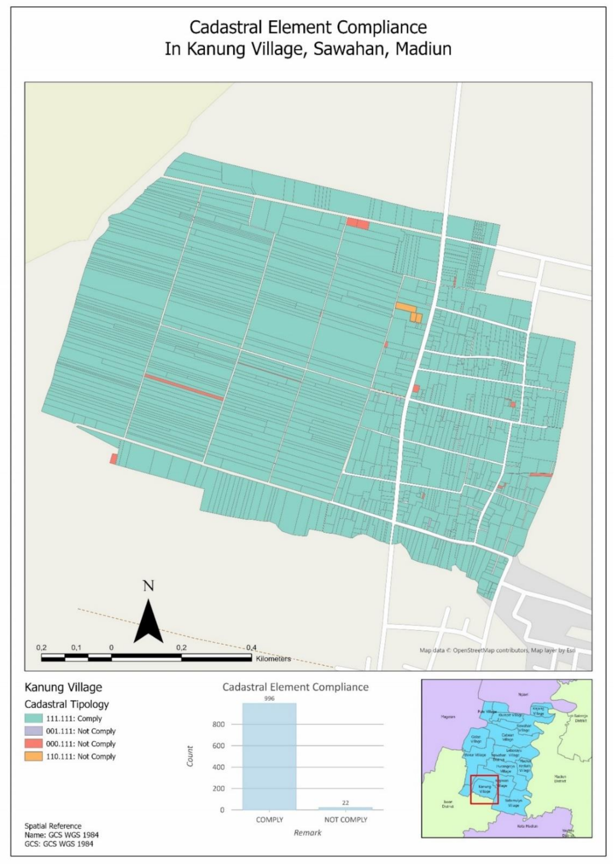
| Kanung | 357 | 624 | 18 | 0 | 19 | 999 | 19 | 117 | 182 | 607 | 93 | 3 | 16 | 996 | 22 | 1018 |
| Krokeh | 377 | 283 | 1 | 0 | 4 | 654 | 11 | 83 | 28 | 324 | 191 | 39 | 0 | 615 | 50 | 665 |
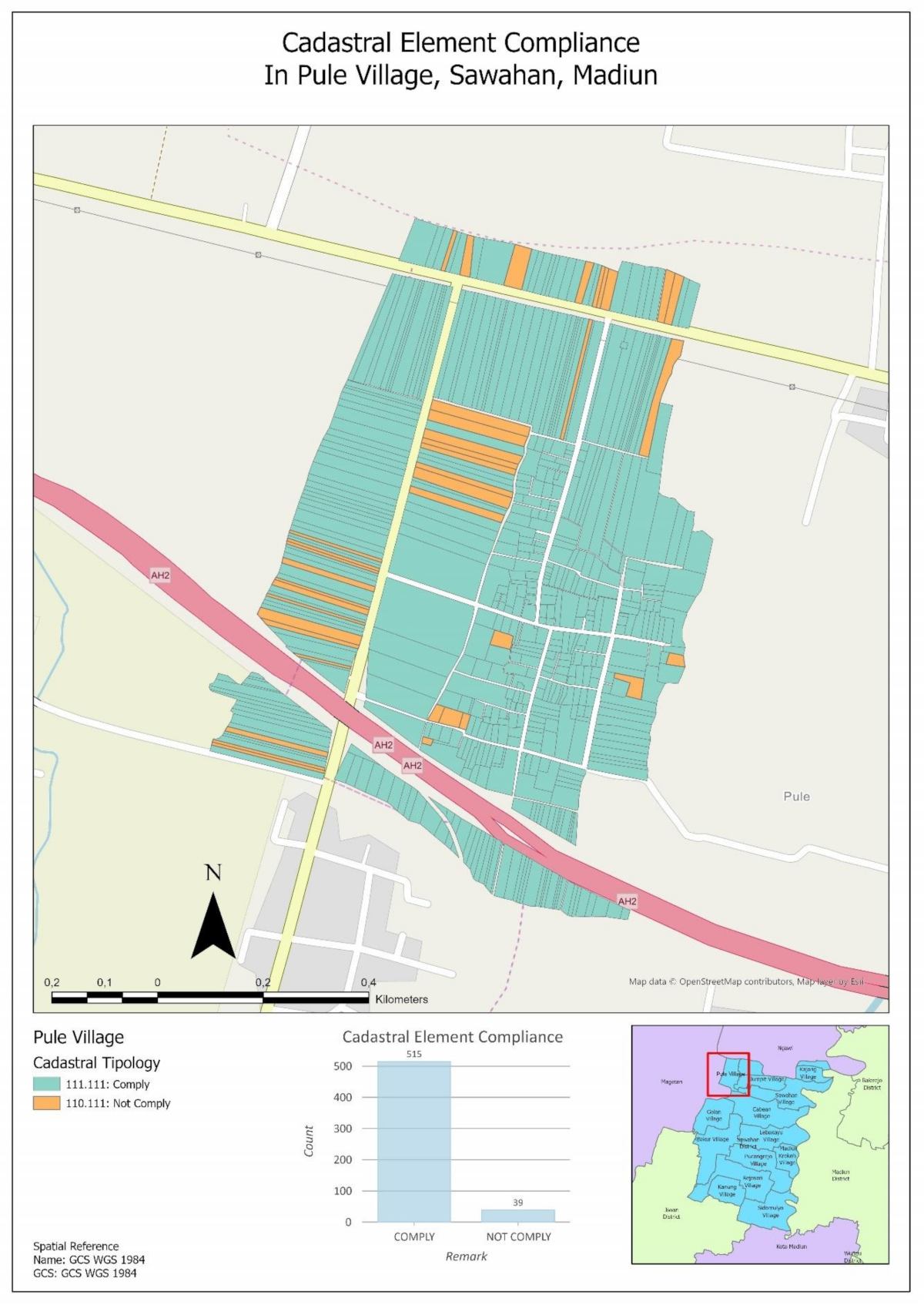
| Pule | 248 | 306 | 0 | 0 | 0 | 554 | 0 | 32 | 10 | 291 | 182 | 39 | 0 | 515 | 39 | 554 |
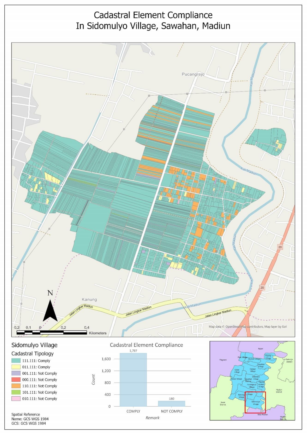
| Sidomulyi | 894 | 988 | 4 | 54 | 37 | 1936 | 41 | 0 | 241 | 1422 | 173 | 5 | 136 | 1797 | 180 | 1977 |
| Cabean | 71 | 1089 | 0 | 110 | 50 | 1181 | 139 | 228 | 253 | 610 | 11 | 127 | 91 | 1021 | 299 | 1320 |
| Bakur | 776 | 1217 | 24 | 0 | 1 | 1972 | 46 | 135 | 586 | 1121 | 63 | 100 | 13 | 1859 | 159 | 2018 |
| Total | 2723 | 4507 | 47 | 164 | 111 | 7296 | 256 | 595 | 1300 | 4375 | 713 | 313 | 256 | 6803 | 749 | 7552 |
Publisher’s Note: MDPI stays neutral with regard to jurisdictional claims in published maps and institutional affiliations. |
© 2021 by the authors. Licensee MDPI, Basel, Switzerland. This article is an open access article distributed under the terms and conditions of the Creative Commons Attribution (CC BY) license (http://creativecommons.org/licenses/by/4.0/).
Share and Cite
Martono, D.B.; Aditya, T.; Subaryono, S.; Nugroho, P. The Legal Element of Fixing the Boundary for Indonesian Complete Cadastre. Land 2021, 10, 49. https://doi.org/10.3390/land10010049
Martono DB, Aditya T, Subaryono S, Nugroho P. The Legal Element of Fixing the Boundary for Indonesian Complete Cadastre. Land. 2021; 10(1):49. https://doi.org/10.3390/land10010049
Chicago/Turabian StyleMartono, Dwi Budi, Trias Aditya, Subaryono Subaryono, and Prijono Nugroho. 2021. "The Legal Element of Fixing the Boundary for Indonesian Complete Cadastre" Land 10, no. 1: 49. https://doi.org/10.3390/land10010049
APA StyleMartono, D. B., Aditya, T., Subaryono, S., & Nugroho, P. (2021). The Legal Element of Fixing the Boundary for Indonesian Complete Cadastre. Land, 10(1), 49. https://doi.org/10.3390/land10010049