Article

Spatial Agglomeration Pattern and Driving Factors of Grain Production in China since the Reform and Opening Up

1
College of Economics and Management, Northwest A&F University, Yangling 712100, China
2
Center for Resource Economics and Environment Management, Northwest A&F University, Yangling 712100, China
*
Author to whom correspondence should be addressed.
Land 2021, 10(1), 10; https://doi.org/10.3390/land10010010
Submission received: 1 December 2020 / Revised: 22 December 2020 / Accepted: 23 December 2020 / Published: 25 December 2020
(This article belongs to the Section Land Socio-Economic and Political Issues)

Abstract

:
Since the reform and opening up, regional imbalances in the development of market economy and urbanization have significantly changed the spatial agglomeration pattern of grain production (GP) in China. To characterize GP by the yield, we used the gravity center (GC) and standard deviation ellipse (SDE) to investigate the evolution characteristics of the spatial agglomeration pattern of GP and its three major crops with wheat, maize and rice in China, then establish a spatial econometric model to explore the natural and socioeconomic drivers of GP at the national level, at different crops and at different regions. The research results indicate that the GC of GP gradually shifts and expands to the northeast and presents a spatial distribution pattern in a “northeast–southwest” direction. The GC of wheat production mainly expands upwards in the east–west direction. The GC of maize production shifts in a direction that is more consistent with grain production, and there is an expansion trend in the east–west direction, while the GC of rice production has the largest north–south span, and continues to expand upward to the north by the east. The status of grain production in Northeast China and Northwest China is rising and the importance of grain production in the Southeast coastal areas are decreasing. The importance of wheat and corn production in North China continues to strengthen, and Northeast China is becoming more important for rice production, but the middle and lower reaches of the Yangtze River are still important rice producing regions. Changes in GP with significant spatial dependence are jointly affected by many factors, such as natural and socio-economic factors, and there are obvious differences among different food crops and different division regions, with the most prominent positive effects being the multiple crop index (MCI), arable land per capita (AL) and agricultural mechanization (MECH), while economic growth and urbanization are significantly negative.

1. Introduction

The second of the 17 global Sustainable Development Goals (SDGs) set by the United Nations is to end hunger, achieve food security, improve nutrition and promote sustainable agriculture [1]. Since the end of 2019, there have been successive outbreaks of desert locusts in Africa, forest fires in Australia and novel coronavirus pneumonia (COVID-19), with the novel coronavirus pneumonia and the African desert locust outbreak increasing the uncertainty of global agricultural supply. This has caused fluctuations in the food market, and some countries have begun to ban agricultural exports for self-protection, further highlighting the global anxiety over food security [2].
China has a large population, but arable land accounts for only 14% of the country’s land area [3]. Thus, food security is related to the stable development of the national economy and society, and ensuring food security is also China’s greatest contribution to global food security. Since the reform and opening up of China in 1978, China’s GP has made world-renowned achievements. Grain yield per unit area and total volume have been increasing, especially since 2003; GP has also achieved a trend of “twelve years of consecutive increase in production” and the grain supply has been transformed from a long-term shortage to a basic balance of total volume [4].
However, the deep, market-oriented reform of the agricultural economy and the uneven development of urbanization caused an obvious imbalance in China’s regional food self-sufficiency rate [5] and led to significant changes in the spatial agglomeration pattern of regional GP. As shown by the changing trend of the proportion of GP in the north and south of China [6], the spatial agglomeration pattern of GP is intuitively manifested by the proportion of northern GP in China increased from 40.90% in 1978 to 50.96% in 2005, and then increased to 58.61% in 2018, while the proportion of southern GP in the country declined from 59.10% in 1978 to 49.04% in 2005, and then to 41.39% in 2018. The year 2005 was about the turning point for the north and the south.
At present, the level of GP in the north has completely surpassed that in the south, and the “south-to-north transfer” pattern of production and marketing has gradually been replaced by “north-to-south transfer”, i.e., “the grain growth center in the south gradually moves westward” and “the national grain growth center gradually moves northward” [7]. The No. 1 document of the Communist Party of the China Central Committee in 2019 continues to focus on agriculture, rural areas and farmers, pointing out that we should not relax our focus on GP and focus on the responsibility of stabilizing food production in the main sales area and the production and sales balance area [8]. However, the main marketing regions in the south have convenient conditions for food production, such as abundant water resources and solar thermal resources, but they have to rely on the main producing regions in the north, which have poorer water, soil and solar thermal resources, to meet the food gap. So, what is the spatial and temporal evolution pattern of GP? And what are the main driving factors behind it? A profound understanding of the changes in the spatial pattern of China’s GP and an exploration of its key influencing factors can help to rationally allocate the input structure of factors and accurately understand food issues at different levels such as production, consumption and circulation, as well as grasp the development direction of the grain production layout and guarantee food security.
After 1995, many scholars began to focus on and study the changes in the spatial agglomeration characteristics of GP. Some scholars have concluded that the GP tends to shift from the “central” areas in the east and central to the “peripheral” areas in the northeast and west through the changes in the GP index [9]. Based on GIS-related technology, a scholar showed that the GP areas are gradually concentrated in the northeast and the middle, the importance of rice in the northeast has gradually become prominent and the wheat and corn production areas have gradually concentrated in the north [10]. In short, most scholars have concluded that the center of GP is gradually moving northward [11,12,13]. In addition, some scholars have theorized about the underlying causes from different perspectives [14,15]. Zheng et al. [16] argued that the turning point of the south-to-north and north-to-south grain transfers was in the mid-1980s after combing through historical data, and that what led to this change was the difference in the comparative advantages of GP in the economic development of the north and south regions in the process of market-oriented reform, so that farmers mainly reorganized their resources according to the relative prices of factors and comparative returns. Lu et al. [17] pointed out that the scale of the grain gap in East and South China will continue to expand, Northeast and North China will show a rapid growth in corn-led food production and exceed demand growth, Central and South China will shift from shortage to basic self-sufficiency in food and Southwest and Northwest China will continue to maintain the existing gap in scale.
There has been considerable research about the influences behind GP [18]. Song et al. explored the key influencing factors of GP based on analyzing the change in arable land productivity, which was the cause of the disparity between arable land area and grain output changes, and it found that farmers ‘willingness to grow grain, which determines arable land use intensity, is the key factor [19]. Lu et al. analyzed the influencing factors based on revealing the characteristics of structural and regional differences in China’s grain production capacity, with both the grain acreage and per capita net income of rural residents having a positive impact on GP capacity [20]. A study by Yawson et al. for the UK found that while spring barley production would benefit under climate change, the total land area allocated to barley production would determine whether it can be self-sufficiency, and the UK could face a large deficit in domestic feed barley production if the area is not expanded [21]. At the same time, most studies point out that arable land resources per capita and technological progress are important factors influencing changes in GP [22,23,24]. In addition, factors such as climate change [25], labor force changes [26], fertilizer application [27], economic and social environment [28] and urbanization [29] also affect GP to varying degrees.
Synthesizing existing studies, scholars have carried out rich and meaningful research on the spatial agglomeration characteristics of China’s GP and the factors influencing it, but there is still room for improvement and exploration. First, there are big differences in the time nodes of most studies, mainly analyzing the changes in the pattern of GP during specific periods, which makes it difficult to fully reflect the changing characteristics of the spatial agglomeration of GP since the reform and opening up. In addition, most studies focus on a particular food crop, while the spatial agglomeration of different food crops is also different, and previous studies have failed to compare and analyze the changes in the spatial agglomeration of major food crops, and previous studies have failed to analyze the changes in the spatial agglomeration of major food crops in a comparative manner. Second, existing empirical tests lack attention to spatial effects, and only individual literature’s quantitative tests consider the spatial spillover effects of GP between regions [4,22]; Tobler’s First Law of Geography also shows that there is a certain connection between everything in the region, and that the closer things are to each other, the stronger their spatial connection will be [30]. With the increasing improvement of China’s agricultural market economy and the expansion of inter-regional openness, the spatial mobility of GP factors such as labor, agricultural machinery services and others has become more and more frequent [31], and it is necessary to explore the impact of neighboring’ GP on the region under spatial interaction effects. Third, there is heterogeneity in agricultural economic levels, urbanization, factor inputs, resource endowments, climatic conditions and geographical locations in different regions, which inevitably leads to differences in GP and how it is affected, while existing research lacks a comparative analysis of the factors influencing the spatial agglomeration of GP in different regions. The research of Deng et al. [32] only provides descriptive statistics of changes in grain production patterns in different regions.
In response to the above research background, this paper attempts to improve and explore the following areas. First, to extend the time interval of the study to the period since the reform and opening up in 1978, based on the production data of grain and three different grain crops of wheat, corn and rice for 31 provinces in mainland China from 1978–2018; the gravity center (GC) and standard deviation ellipse (SDE) model is developed to analyze the shifting characteristics of the gravity and the range of SDEs, in order to gain a comprehensive understanding of the overall spatial clustering evolution of GP and the differences on three major crop types. Second, a spatial panel econometrics model would be established to analyze the drivers of GP changes at the national level in terms of natural conditions, socio-economic environment and so on, and to discuss the heterogeneity of the influencing factors on different food crops and on different regions in order to obtain more explanatory test results. Finally, relevant policy implications are summarized based on qualitative analysis and empirical testing.

2. Materials and Methods

2.1. Variable Selection

The core explanatory variable in this paper is grain production (GP), which is mainly portrayed from the perspective of the scale of grain output, that is, total grain production and its three major crops such as wheat, maize and rice.
The other driver variables are selected from natural endowment conditions, social changes and economic development. GP in different regions is not only subject to changes in farmers’ grain growing behavior due to internal factors such as technical conditions, land resources, factor inputs and comparative returns, but also to external environmental factors such as natural conditions, economic growth, transportation infrastructure, urbanization and agricultural policy adjustment, all of which can make GP in constant adjustment [32]. Based on this, temperature (TEM), precipitation (PRE) and sunshine hours (SUN) are selected from natural conditions to reflect the impact of meteorological conditions on GP, and grain disaster area (GDA) is selected to reflect the impact of GP of natural disasters. The per capita GDP (pGDP), population urbanization rate (URBAN), rural labor transfer (RLT) and non-farm income (NFI) were selected from the socio-economic environment to reflect the effects of economic growth, urbanization level, farmers’ non-farm employment level and comparative returns to crop cultivation on GP. Per capita arable land area (AL) and multiple cropping index (MCI) are selected from the arable land resources and utilization to reflect the effects of basic endowment and arable land utilization on GP. The level of agricultural mechanization and transportation conditions on GP are reflected by labor average mechanical power (MECH) and transportation infrastructure (TRANS) that are selected from agricultural production conditions.
In addition, agricultural policies issued at different historical stages have different effects on GP. The most historical change is the reform of the grain circulation system started in 1993, whereby grain purchase and sales gradually moved towards marketization, and led to rapid growth in GP [33]; in 1996, China’s grain output exceeded the trillion-jin threshold for the first time. Therefore, this paper uses 1993 as the demarcation point to set up a dummy variable of agricultural policy adjustment (APA), to test the impact agricultural policy on GP. Table 1 reports the specific variable selections and their definitions.

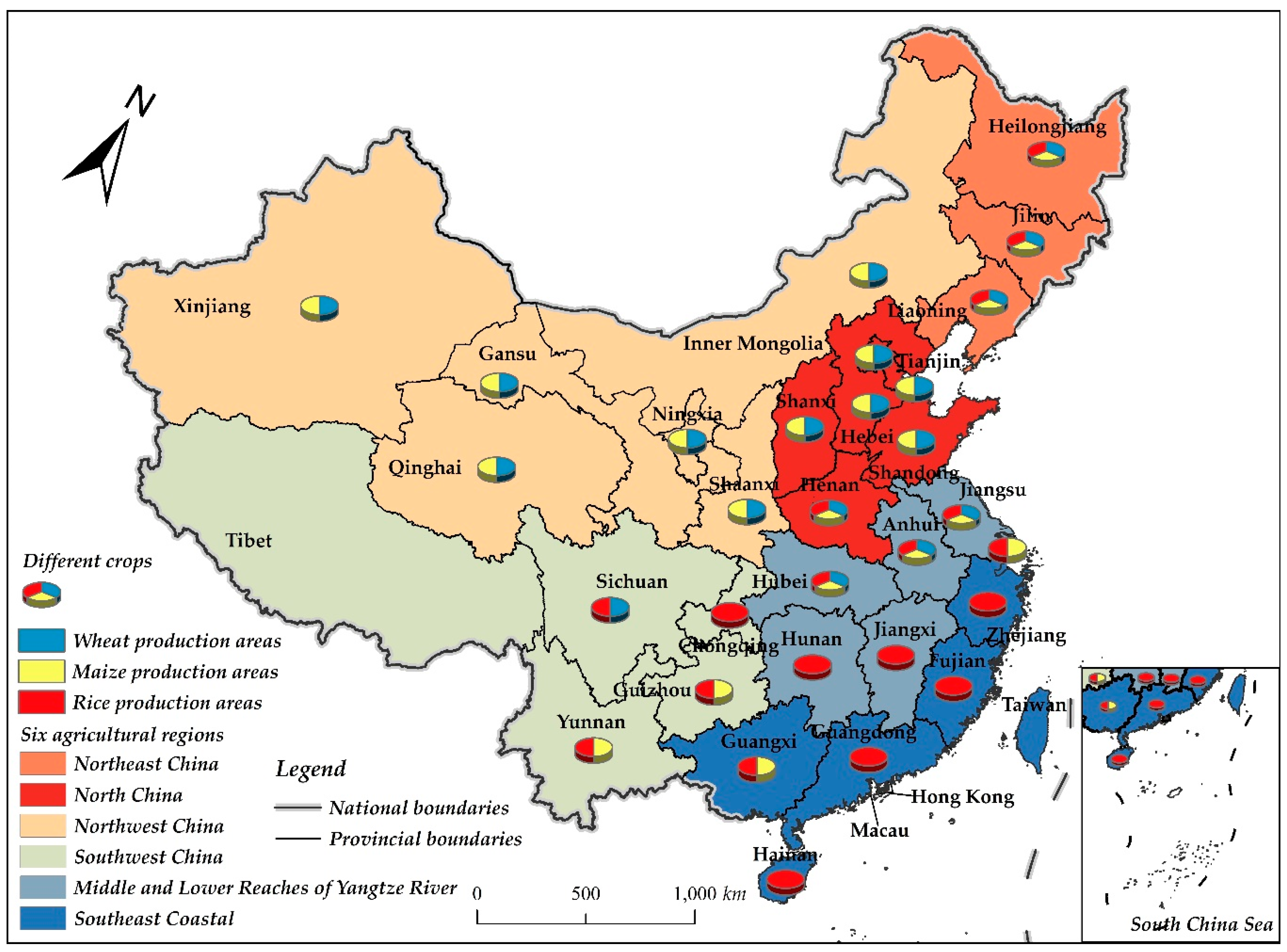
2.2. Data Sources and Regional Distribution

This paper uses the panel data of 31 provinces (municipalities and autonomous regions, excluding Hong Kong, Macao and Taiwan) across China from 1978 to 2018 as the research sample. The total GP and production data of three major crops such as wheat, maize and rice are obtained from the annual data by province from the national data website of the National Bureau of Statistics (data.stats.gov.cn), and other socio-economic data of the variables are derived from the “China Rural Statistical Yearbook”, “China Agricultural Statistical Report”, “Fifty Years of Agricultural Statistics in New China”, “China compendium of statistics 1949–2008” and statistical yearbooks of all provinces. It should be noted that due to gaps in data on rural net income per capita in most provinces prior to 1983, the data used in the driver analysis section covers the time period 1983–2018, excluding Tibet. Some missing data are supplemented by interpolation. Data for Chongqing before 1997 and Hainan before 1988 are obtained from the Chongqing statistical yearbook and Hainan statistical yearbook, with adjustment for the corresponding years in Sichuan and Guangdong. The land mileage data before 2000 are from a compilation of 50 years of statistical data of China’s industrial, transportation and energy sectors (1949–1999). The climate change data such as temperature, precipitation and sunshine hours are from the “China Ground Climatological Value Data Set” of the Meteorological Data Center of China Meteorological Administration (data.cma.cn).
According to the different main production areas of different crops, the provinces are selected based on the criteria that the proportion of each province’s production in 2018 is greater than 1%, and finally 19 provinces are screened for wheat production areas, 22 provinces for maize production areas and 19 provinces for rice production areas.
According to the agricultural zoning of the Institute of Geographic Sciences and Natural Resources, CAS (www.resdc.cn), the country is divided into six zones: Northeast China (NEC), North China (NC), Northwest China (NWC), Southwest China (SWC), Middle and Lower Reaches of the Yangtze River regions (MLY) and Southeast Coastal regions (SEC). In addition, using the Qinling-Huai River as the boundary, the country is roughly divided into northern and southern regions, and the northern region includes 15 provinces of NEC, NC and NWC, while the southern region includes 19 provinces of SWC, MLY and SEC (Figure 1).

2.3. Model Specification

2.3.1. Standard Deviation Elliptic-Gravity Center Model

Standard deviational ellipse (SDE) is an effective method that can accurately reveal the overall characteristics of the spatial distribution of geographical elements [34,35]. The method takes the gravity center (GC) of geographical elements distribution as the center, the main trend direction of element distribution as the azimuthal angle and the standard deviation of elements in the X and Y directions as the elliptical axis, and constructs a spatial distribution ellipse to describe and explain the central, directional and spatial distribution patterns and other features of the spatial distribution of geographical elements [36,37]. The center of ellipse is the gravity center of spatial distribution of economic phenomena, which can reflect the trajectory changes and spatial transfer shift characteristics of GC, so as to understand the development direction of the economic phenomenon more intuitively. The formula for the main parameters of the SDE-GC model is as follows:
X = i = 1 n ω i x i / i = 1 n ω i ;   Y = i = 1 n ω i y i / i = 1 n ω i
σ x = i = 1 n ( ω i x i * cos θ ω i y i * sin θ ) 2 / i = 1 n ω i 2 ; σ y = i = 1 n ( ω i x i * sin θ ω i y i * cos θ ) 2 / i = 1 n ω i 2
tan θ = ( ( i = 1 n ω i 2 x i * 2 i = 1 n ω i 2 y i * 2 ) + ( i = 1 n ω i 2 x i * 2 i = 1 n ω i 2 y i * 2 ) 2 4 i = 1 n ω i 2 x i * 2 y i * 2 ) / 2 i = 1 n ω i 2 x i * y i *
where ( X , Y ) denotes the coordinate of the gravity center (GC) for GP, ( x i , y i ) denotes the spatial coordinates of the study area, ( x i * , y i * ) denotes the relative coordinates of each area and the GC, ω i is the weight, which in this paper is the grain production of the different provinces, σ x , σ y are the standard deviations along the X axis and the Y axis, respectively, and θ is the elliptic azimuth, which is the angle formed by rotating clockwise in the due north direction to the long axis of the ellipse.

2.3.2. Spatial Econometric Models (SEM, SLM)

The basic models of spatial econometric mainly include the SLM (spatial lag model), SEM (spatial error model) and SDM (spatial durbin model), which are characterized by the introduction of spatial effects in the traditional regression model, thus being able to comprehensively reflect the regional correlations and differences of the panel data. Spatial correlation refers to the correlation effect between regions as a result of spatial interaction. Compared with traditional panel regression models, the inclusion of spatial effects ensures to some extent the estimation superiority of the regression results. Where the SLM introduces the spatial lagged term of dependent variable into the model, the SEM introduces the spatial lag of the error term into the model, denoted as
y = α + ρ W y + β X + ε
{ y = α + β X + ε ε = λ W ε + μ
where y and X are the dependent and independent variables, respectively, W is the spatial weight matrix, ρ is the spatial lag term coefficients, λ is the spatial error term factor and ε is the error term, ε , μ ~ N ( 0 , δ 2 I ) .
In selecting a suitable spatial measurement model, the significance of the spatial lag model and the spatial error model should first be tested [38], and if both models are significant or neither is significant, then the SDM should be constructed, which is a spatial lag term that introduces both the dependent and independent variables into the model:
y = α + ρ W y + β X + γ W X + ε
When the coefficient γ = 0, the model degenerates into an SLM.

3. Results

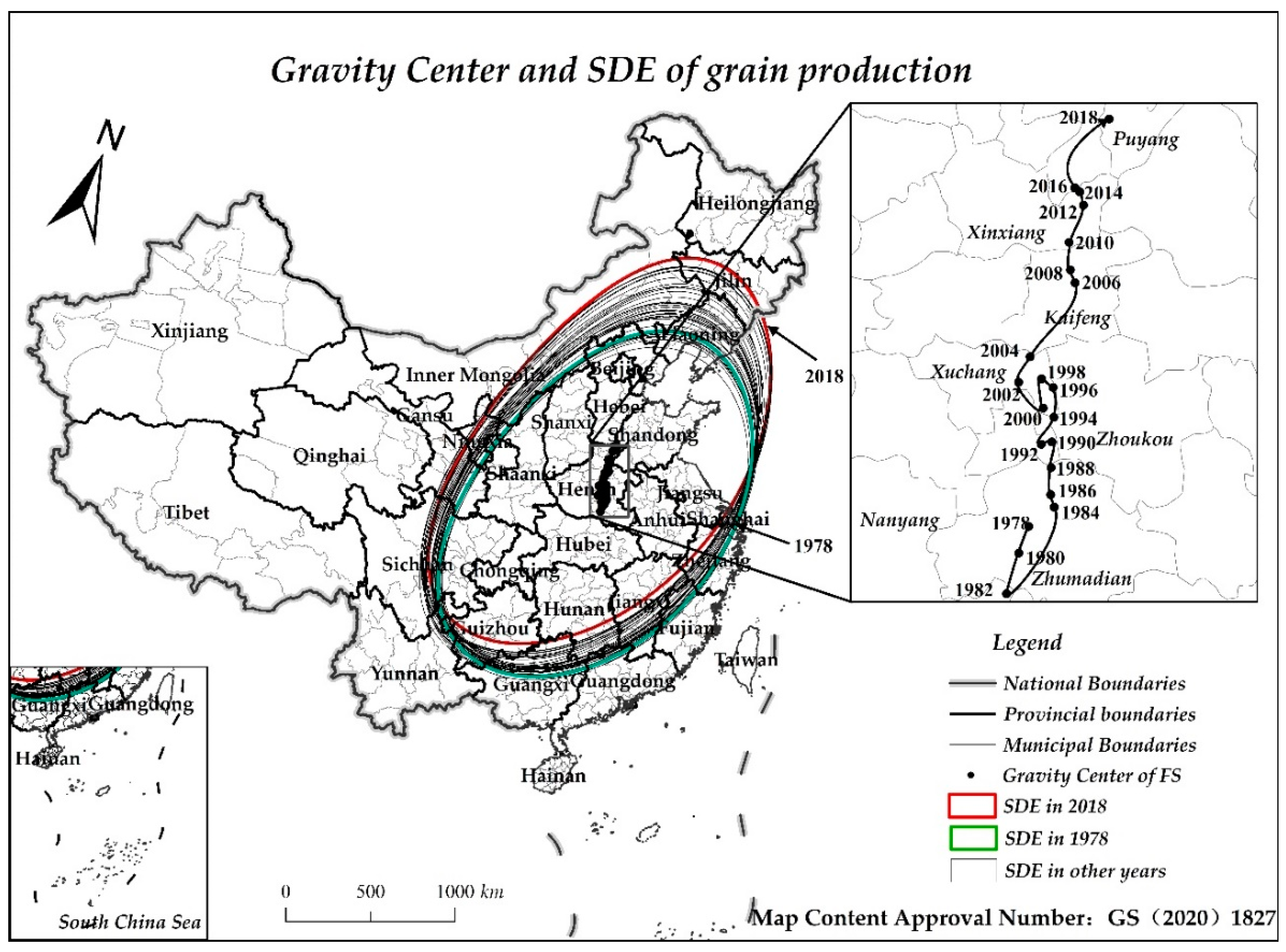
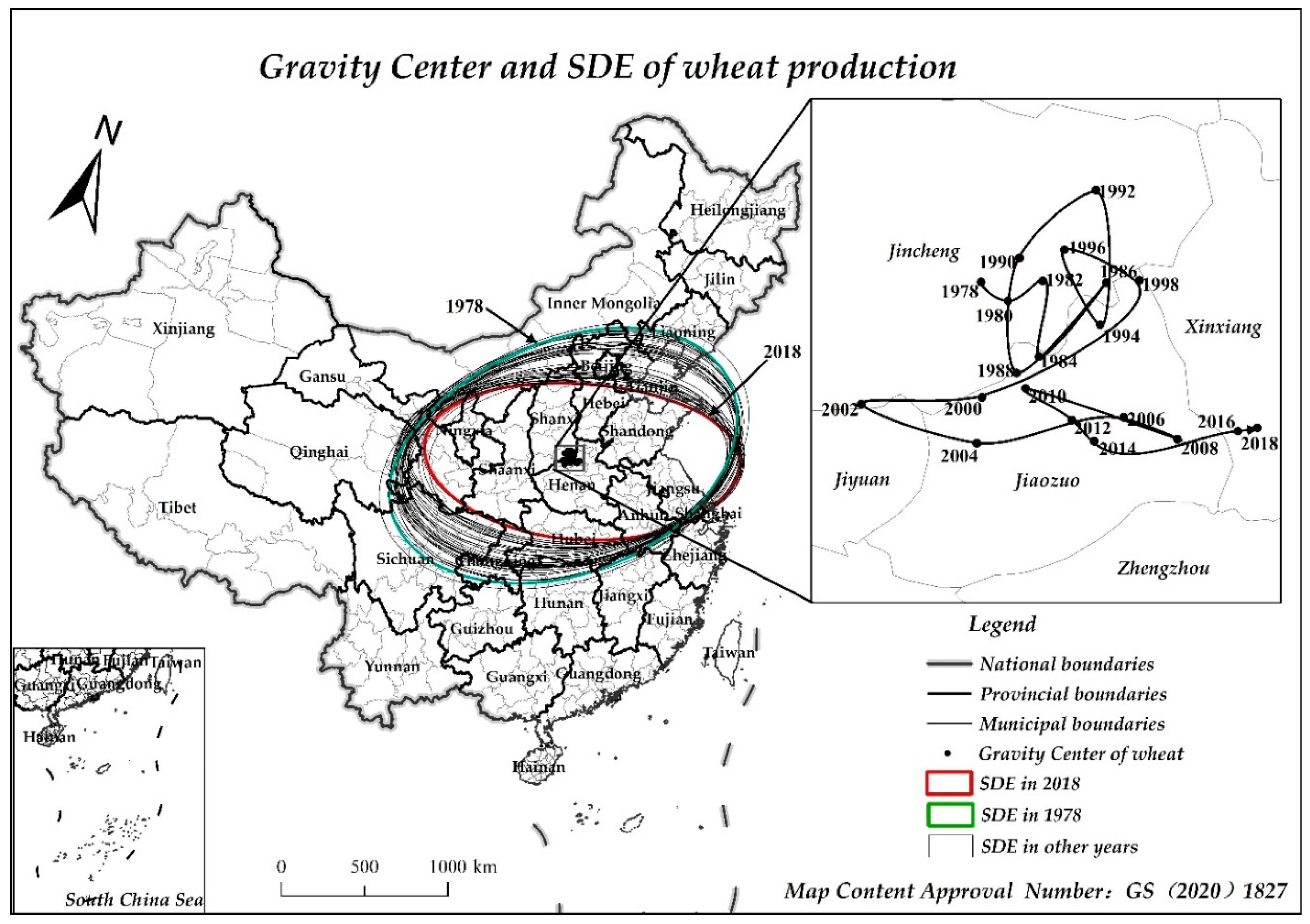
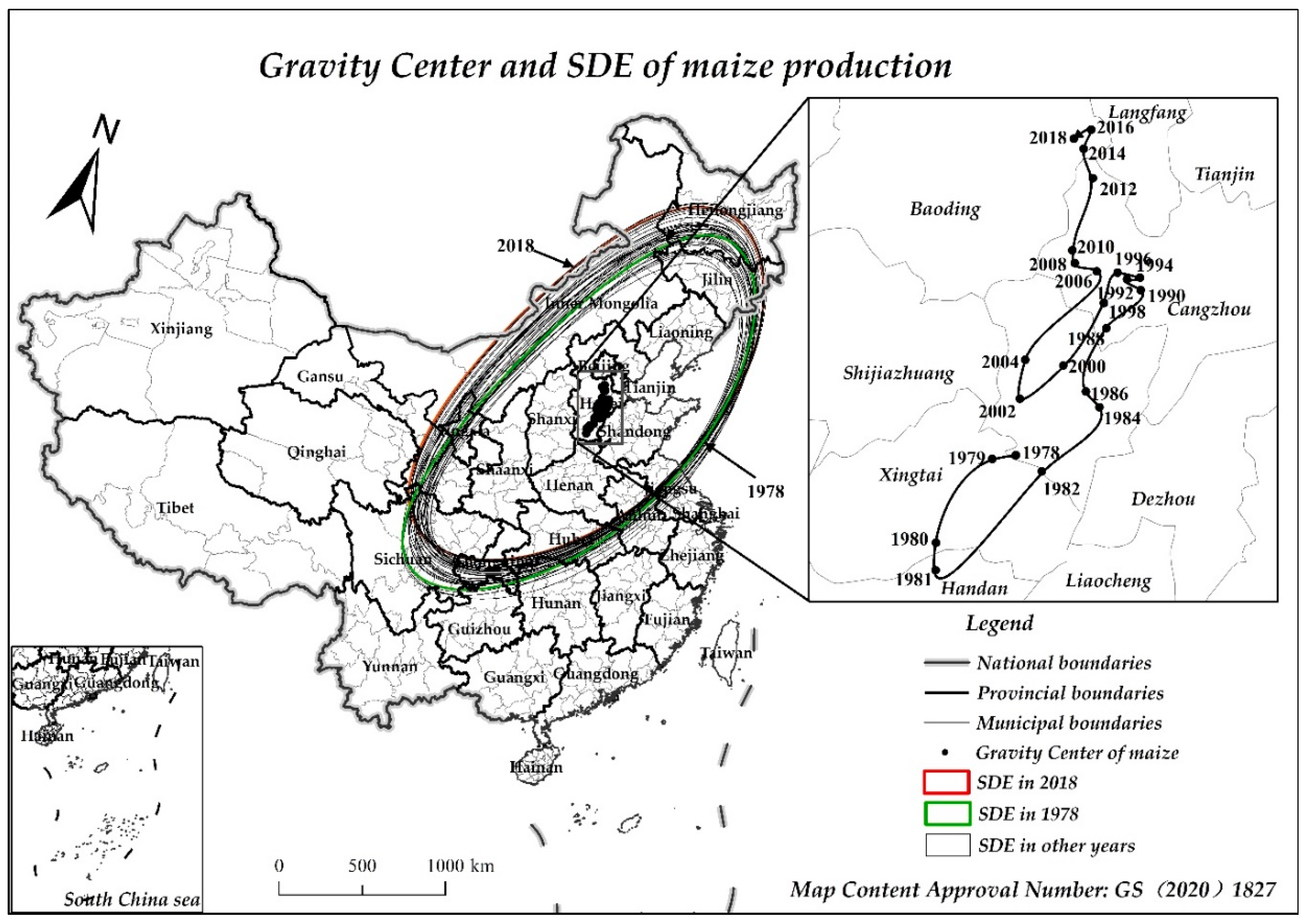
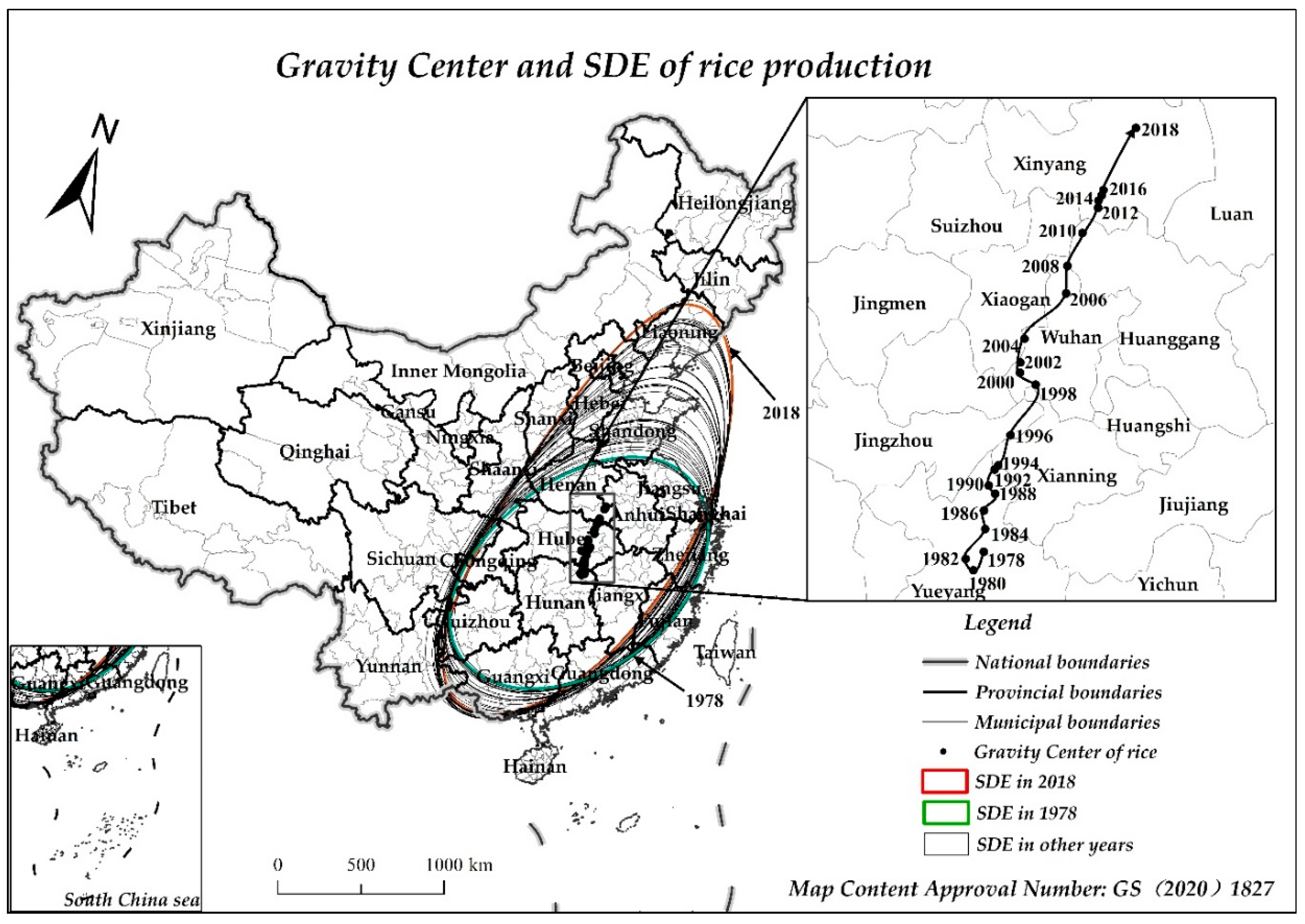
3.1. The Gravity Center and Standard Deviation Ellipses of China’s Grain Production

We mapped the gravity center and standard deviation ellipses of GP and its major crops of wheat, maize and rice production in China from 1978 to 2018 based on the SDE-GC model, so as to analyze their evolutionary characteristics of spatial agglomeration (Figure 2, Figure 3, Figure 4 and Figure 5).

3.1.1. Overall Grain Production

The GC geographical coordinates of GP in China from 1978 to 2018 ranged from 113.739° E~114.993° E and 32.598° N~35.771° N, and always moves within Henan Province, from Zhumadian City in 1978 to Puyang City in 2018, which shows a fluctuating shift to the north by east, overall moving 291.048 km to the northeast and an average annual shift speed of 7.276 km/a. The GC of China’s GP moved steadily northward before 2000, but the distance fluctuated less, and the southern region remained mainly granary, while after 2000, the GC shifted to the northeast at a significantly greater distance and faster speed, and there was a more substantial increase of GP in the northern region. The long axis of the ellipse was extended from 1176.318 km in 1978 to 1379.359 km in 2018, while the short axis has only been extended from 719.919 km to 744.545 km, and the ratio of the short axis to the long axis shows an overall tendency to increase first and then decrease. This was mainly due to the small increase in the short axis, while the long axis maintains a fluctuating growth, as shown by the GP expanding upward in the south–north direction obviously.

3.1.2. Wheat Production

The GC geographic coordinates of wheat production in China from 1978–2018 ranged from 112.580° E~113.713° E and 35.036° N~35.766° N, with a small change in latitude and longitude, and an overall shift of 85.126 km to the southeast, which shows a fluctuating change process in the northwest–southeast direction. In most years, the GC shifted back and forth between Jiaozuo City, Henan Province, and Yuncheng City, Shanxi Province, which is basically located due west by north of the GP. The SDE of wheat production basically covers the main wheat producing areas in China. The long axis of the ellipse shrinks from 1212.743 km in 1978 to 1058.571 km in 2018, while the short axis shrinks accordingly from 648.414 km to 431.655 km, and both the long and short axes show different degrees of shrinkage; the azimuth angle has exceeded 90°, which indicated that the coverage of wheat production was decreasing, and it was contracting in the east–west direction and the north–south direction.

3.1.3. Maize Production

The GC geographic coordinates of maize production in China from 1978–2018 ranged from 114.813° E~116.132° E and 36.865° N~38.989° N, basically moving within Hebei Province and shifting from Xingtai City in 1978 to Baoding City in 2018, where it is directly north-east of the GC of overall GP. The GC of maize production moved 174.175 km to the northeast overall, with an average annual transfer rate of 4.354 km/a, which were fluctuations in the process of movement, and the speed and distance at which the GC shifted northward increased significantly after 2002. The SDE long axis of maize production shrank slightly from 1497.502 km in 1978 to 1495.272 km in 2018, while the short axis lengthened from 573.074 km to 660.023 km, so the main body of maize production is more reflected in the east–west expansion, with a slight contraction in the north–south. In addition, the change in elliptical azimuth further confirms the shift of maize production to the north by the west.

3.1.4. Rice Production

The GC geographic coordinates of rice production in 1978–2018 range from between 113.285° E~115.200° E and 28.897° N~32.280° N, which is basically located directly south of the GC of overall GP. The GC of rice shifted from Yueyang, Hunan Province, in 1978, across Hubei Province and to Xinyang, Henan Province, in 2018, with a large span in the north-south direction, with moving 371.147 km to the northeast on the whole, with an average annual transfer rate of 9.279 km/a. The long axis of the ellipse has extended from 867.589 km in 1978 to 1369.110 km in 2018, and gradually transitioned from a partial east-west direction to a northeast-southwest direction, while the short axis changed from 524.931 km to 545.313 km, with a smaller expansion, but a larger directional shift. In addition, the gradual decrease in azimuthal angle also indicates the characteristic shift of rice production to the northeast.

3.2. Analysis of the Driving Factors of Grain Production in China

3.2.1. Spatial Correlation Test and Econometric Model Selection

The global Moran’s I was used for the spatial correlation test before modeling, and the geographic distance weight matrix with row standardized was constructed using the reciprocal of the longitude and latitude distance based on the geometric center of the region [39]. The results show that Moran’s I (0.124 to 0.303) is greater than 0 and passes the 5% significance level, indicating that GP has spatial agglomeration and correlation.
Before parameter estimation, a choice needs to be made between the spatial lag model (SLM) and the spatial error model (SEM). The optimal model was selected according to the following principles [40]: (i) The model with higher explanatory power was selected according to the Akatsuki Information Criterion (AIC); the lower the AIC value and the higher the explanatory power. (ii) The model’s suitability was determined according to the LogL, R2 and Sigma2 statistics; the higher the LogL and R2 and the lower the Sigma2 indicates a higher degree of model fit. The fixed effect is relatively effective when the panel data is long enough, and in combination with the Hausman test [41,42], finally selecting a fixed effect model to test. In addition, take the logarithm of variables other than the policy dummy variable to eliminate their heteroscedasticity.

3.2.2. At the Level of GP and Different Crops

The spatial effect coefficients of both models are significantly greater than zero, indicating that there is an obvious spatial dependence and spillover feature of GP in China, and the direction and degree of estimated coefficients of the variables do not show large differences, indicating that the results are more robust. According to the discriminant principle, the SEM for GP is superior to the SLM, while the SEM for wheat and maize production is superior and the SLM for rice production is superior (Table 2).
In terms of overall GP, among the natural condition variables, only PRE has a significantly positive effect on grain yield, while the positive effects of TEM, SUN and GDA are not significant. Among the socio-economic environmental variables, pGDP and URBAN had significant negative effect on GP, while RLT had a significant positive effect; however, the effect of NFI did not pass the significance test. Among the other variables, AL, MCI, MECH and APA all had positive effects on GP, but the positive effect of TRANS did not pass the significance test.
In terms of the production of the three major food crops, the response of different crop production to natural condition variables is different [43], and only the positive effect of PRE on maize production and the positive effect of TEM on rice production are significant, while the effects of other natural condition variables on the production of three crops are not significant. Among the other variables, the significance and direction of pGDP, AL, MCI, MECH and APA consistent with GP. Focusing on indicators that differ from the impact on GP, the negative effect of GDA on rice production is not significant, and the positive effect of URBAN on wheat production is not significant. While the negative effect of RLT on wheat production is not significant, NFI has a positive effect on rice production, but at a low significance level, and the negative effect of TRANS on rice production is not significant.

3.2.3. At the Level of Different Regions

According to the south–north division and six major agricultural zones in Figure 1, we have established spatial econometric models with fixed effects to test and compare the differences of GP impacts among regions (Table 3).
In the north and south, RLT, AL, MCI, MECH and APA all have positive effects on GP, while the effects of pGDP and URBAN are significantly negative, but the negative effect of pGDP and the positive effect of APA in the north are not significant. Only PRE and SUN have significant positive effects on GP in the north under natural conditions. The positive effect of GDA and TRANS are not significant in the south and north.
In the six agricultural zones, there are significant positive effects of RLT, AL, MCI, MECH and APA on GP in Northeast China, while GDA, pGDP and URBAN are significantly negative. The variables of natural conditions, RLT, AL, MCI, MECH, TRANS and APA have significant positive effects on GP in North China, while the effects of pGDP and URBAN are significantly negative—basically similar to the results for GP. There are significant positive effects of RLT, AL, MCI and MECH on GP in Northwest China, while the effects of TEM, URBAN, NFI and TRANS are significantly negative. The variables showing significant positive effects in Southwestern China are closer to those in Northwest China, while those showing significant negative effects include TEM, AL, URBAN and MECH. The effects of variables in the middle and lower reaches of the Yangtze River differed from those in other regions, and the positive effects of URBAN, NFI, AL and MCI are not significant. The decline of GP in the southeast coastal area is mainly negatively affected by natural conditions, GDA, pGDP, URBAN and TRANS.

4. Discussion and Conclusions

Since the reform and opening up, the spatial pattern of GP in China has undergone profound changes, the GC of GP has gradually moved toward the northeast and its SDE covered most of the major grain production areas in the east, middle and west of the country. The coverage of the northern provinces is gradually expanding, and the spatial agglomeration and distribution pattern of GP shifting and expanding to the north, especially the northeast, is forming. This is generally consistent with the findings of existing studies [44,45]. In terms of yield, the change of GP can be attributed to the fact that grain yield has been rising in Northeast China and Northwest China, while gradually declining in the economically developed south, especially in the southeast coastal region. Previous studies have paid less attention to the production pattern of different grain crops, and this paper finds that the production patterns of three crops show different evolutionary characteristics. The GC of wheat production mainly shifted in the east–west direction, with a more volatile and irregular shift process, and the change in SDE reflected the contraction of the range of wheat production, and showed a spatial agglomeration pattern with the Yellow River basin and the northern part of Yangtze plain as the main. This stemmed from the decline in the Northeast China, which began to gradually decline after reaching a peak of 5.326 million tons in 1990, to only 375,900 tons in 2018. The GC and SDE of maize production are like GP in that there is an overall dynamic shift toward the northeast. The northern provinces included in the ellipse gradually increase; however, the growth of maize yield in Northwest China made the SDE mainly show an expansion to the west and contraction to the north. The status of maize production in northern China is further strengthened, and the agglomeration pattern gradually shifted to Northeast China, North China and Northwest China. The GC and SDE of rice production moved and expanded to the northeast obviously and moved a significantly larger distance than wheat and maize. The ellipse covered the major rice production areas in the country; however, the number of northern provinces included has gradually increased, especially in Northeast China, where the share in the country increased from 2.95% in 1978 to 2018 17.68%; the status of production also increased. However, the share in the middle and lower reaches of the Yangtze River is still above 40%, and the production position remains solid. Overall, the spatial agglomeration of GP in China has gradually shifted to the northeast, which plays an increasingly important role in ensuring national food security.
The change in GP with spatial dependent is affected by natural, socio-economic and other factors, and there is significant heterogeneity across grain crops and regions. The existence of spatial spillover effect indicates that the GP in this area is also affected by the positive spillover impact of neighboring areas. For GP, economic growth (pGDP), urbanization (URBAN) and non-farm income (NFI) are expected to have negative effects on grain growth, while other variables have positive effects on GP to different degrees, among which the most influential variable is multiple cropping index (MCI), followed by arable land resources (AL). Only the positive effect of PRE on GP is significant among natural conditions. Increased precipitation can reduce irrigation to maintain crop water and to benefit GP, but excessive precipitation is prone to flooding, while the reduction of GP due to drier climates caused by decreased precipitation is inevitable [46]. Focused analysis of the main factors affecting GP, pGDP through the free flow of production factors in the market and the existence of comparative advantage, have led to the allocation of more factor resources to more efficient industrial and service sectors; the upgrading of industrial structure also has affected the redistribution of agricultural factor input. In addition, with the increase of economic growth and per capita income, people’s demand for food consumption has become increasingly diversified, which is indirectly leading to the “non-grain” structure of GP. URBAN affects the input structure of agricultural factors mainly through the encroachment of arable land by land expansion and the concentration of rural labor in cities and towns, which have an impact on GP. The MCI can reflect a change of crop maturity and the utilization degree of arable land, which can effectively increase grain yield by fully exploiting the potential. The AL owned by farm households is the basis for GP, and the expansion of AL helps to increase grain yield through mechanization and large-scale production. In addition, the popularization of agricultural mechanization can form an effective alternative to human and animal power, releasing surplus rural labor, thus engaging in large-scale GP with less labor, increasing labor productivity and reducing labor intensity.
In terms of different grain crops, the focus is on indicators that differ in their impact on GP. Increased PRE favors regional maize production, while warmer TEM favors regional rice production. GDA did not have a large impact on rice production, and the increase in the share of rice yield in Northeast China is conducive to securing the national rice supply. URBAN and RLT did not have a significant impact on wheat production. Due to the vast area of hills, crisscrossed rivers and lakes in the rice producing areas, TRANS has limited impact on rice production.
At the level of north–south, pGDP has not had a significantly negative effect on GP in the north, which will become increasingly important as the GC for GP shifts northward. Increased PRE and enough SUN have a significant positive effect on GP in the north but did not significantly affect GP in the south. GDA and TRANS did not have a large impact on GP in both the south and north. The effects of other variables are like those of GP.
At the level of the six agricultural zones: (1) Northeast China. PRE and SUN in natural conditions, as well as pGDP, URBAN have not led to a decline in GP. On the one hand, it has a high latitude, mild and humid climate, sufficient sunshine, better conditions for agricultural production and fewer grain disasters, which are conducive to crop growth; on the other hand, the continuous development of large-scale grain growing households and family farms has consolidated the position of Northeast China as the most important commodity grain production base. (2) North China. The greater degree of positive influence on GP are MCI, AL and MECH, which are more consistent with the main positive factors at the national level. (3) The increase in non-farm employment opportunities brought about by URBAN has increased the non-farm income of farm households, enhanced the attractiveness of non-farm employment and led to lower returns from grain cultivation, which is detrimental to GP, while the negative impact of TRANS may lie in the northwest region which is sparsely populated, due to high transport costs. (4) Southwest China. It is in Yunnan-Guizhou Plateau and Sichuan basin, and the improvement of economic development has led to a shift in the people’s consumption structure of agricultural products to non-grain. In addition, the higher topographic relief in the region leads to higher transportation costs and inconvenient mechanized operations, as well as the ageing and feminization of the labor force structure due to rural population shifts, which are not conducive to higher GP. (5) Middle and Lower Reaches of the Yangtze River. It has a high level of URBAN and a large concentration of population in towns and cities. Developed non-agricultural industry promotes the upgrading of grain consumption structure. In addition, the region’s AL is decreasing, MCI is difficult to improve, abandonment of cultivation occurs from time to time and the supply of food demand is gradually coming from transactions outside of the region. (6) Southeast Coastal. The negative influence of natural conditions in this area is mainly the frequent occurrence of natural disasters. Since the reform and opening up, the economic growth rate of the region is significantly higher than that of other regions. The continuous development of urbanization has gradually increased employment opportunities for farmers in non-agricultural sectors, while the number of farmers engaged in GP has been decreasing, As the GC of GP gradually shifts northward, the consumption demand for food mainly comes from the main production areas in the north.
Since the founding of New China, especially since the reform and opening up, the long-term shortage of food in China has basically been solved, but with the deepening of marketization and urbanization, and the continuous promotion of agricultural technology, the spatial agglomeration pattern of food production in China has undergone profound changes. The priority and rapid development of the economy and urbanization in the eastern and southern regions, and non-farming of land use, have prompted a gradual shift of the food production center from south to north. The status of food production in Northeast and North China will continue to be prominent. In the Northeast, as a strategic base for national GP with excellent natural resource endowments and agricultural production conditions, the potential for increased food production is greater [47], while North China’s food production, although currently in an important position, has limited potential for long-term increases due to the constraints of high population density, water shortages and accelerated urbanization. Thus, it is foreseeable that the center of food production will continue to move to the northeast.
In addition, GP in different crops and different regions is affected by different natural conditions and socio-economic environments, so that governments should grasp the objective law of food production, including which structure should be optimized in accordance with the advantages of different crop-producing areas according to local conditions and material conditions. Based on ensuring basic farmland and strictly observing the red line for arable land, governments should continue to increase investment in agricultural science and technology, promote technological progress in irrigation, fertilizer reduction, mechanization etc. and improve transportation infrastructure conditions. In the process of urbanization, governments should also strictly delineate the border between urban land and agricultural land, raise the multiple cropping index and fully explore the utilization potential of arable land use.
Food security is a complex system encompassing supply capacity, access capacity, supply and demand stability, healthy food, trade flow, etc., and grain production is only one important component of food security. In future studies, food security will be assessed by establishing a comprehensive index system, examining the spatial and temporal variation of food security among regions in China, and focusing on the impact of changes in production environments, such as intensive agricultural production, environmental pollution and use of GMO on food security. In addition, it is worth pondering that water shortage is a prominent problem in the north; the long-term over-exploitation of groundwater has already had a serious negative impact on the ecological environment and constrained the sustainable development of agriculture. However, the northward shift of the food production center will certainly be at the expense of water resource depletion [5] (can the South-North Water Transfer Project, which mainly supplies water to North China, continue to transfer water?). In the context of food security, how can sustainable food production in the north be promoted in parallel with economic growth and urbanization? It will be a key issue for future research.

Author Contributions

Conceptualization, M.H. and S.Y.; methodology, M.H.; software, Y.D.; validation, S.Y., and M.H.; formal analysis, M.H.; investigation, M.H.; resources, Y.D.; data curation, M.H., and Y.D.; writing—original draft preparation, M.H.; writing—review and editing, Y.D. and S.Y.; visualization, M.H. and Y.D.; supervision, S.Y.; project administration, M.H.; funding acquisition, S.Y. All authors have read and agreed to the published version of the manuscript.

Funding

This research was funded by the National Natural Science Foundation of China, grant number 71473195, 71773091; Special Fund for Scientific Research of Forestry Commonwealth Industry, grant number 201504424 and Graduate Student Science and Technology Innovation Program of College of Economics and Management, Northwest A&F University, grant number JGYJSCXXM2020002.

Institutional Review Board Statement

Not applicable.

Informed Consent Statement

Not applicable.

Data Availability Statement

Data sharing not applicable. No new data were created or analyzed in this study. Data sharing is not applicable to this article.

Conflicts of Interest

The authors declare no conflict of interest.

References

  1. Pecl, G.T.; Araújo, M.B.; Bell, J.D.; Blanchard, J.; Bonebrake, T.C.; Chen, I.C.; Clark, T.D.; Colwell, R.K.; Danielsen, F.; Evengård, B.; et al. Biodiversity redistribution under climate change: Impacts on ecosystems and human well-being. Science 2017, 355. [Google Scholar] [CrossRef] [PubMed]
  2. Galanakis, C.M. The Food Systems in the Era of the Coronavirus (COVID-19) Pandemic Crisis. Foods 2020, 9, 523. [Google Scholar] [CrossRef]
  3. Ministry of Land and Resources, PRC. 2016 China Land Resources Bulletin. 2017. Available online: http://www.mnr.gov.cn/sj/tjgb/ (accessed on 11 December 2020).
  4. Lu, W.C.; Mei, Y. Empirical studies on the variation and contributing factors of regional grain production structure in China: Based on spatial econometrics models. China Agric. Univ. J. Soc. Sci. Ed. 2007, 140–152. [Google Scholar] [CrossRef]
  5. Zhiyu, X.; Zhenwei, S.; Aixing, D. Regional changes of production layout of main grain crops and their actuation factors during 1981–2008 in China. J. Nanjing Agric. Univ. 2013, 36, 79–86. [Google Scholar] [CrossRef]
  6. Zhong, F.N.; Lu, W.Y.; Xu, Z.G. Is it not conducive to grain production for rural labor force to go out go out to work? Analysis on the behavior and constraints of farmers’ element substitution and planting structure adjustment. Chin. Rural Econ. 2016, 7, 36–47. [Google Scholar]
  7. Huang, A.J. The change law of regional pattern of grain production in China. Chin. Rural Econ. 1995, 2, 31–33. [Google Scholar]
  8. Ministry of Agriculture and Rural Affairs, PRC. The No. 1 document of the Communist Party of China Central Committee. 2019. Available online: http://www.moa.gov.cn/ztzl/jj2019zyyhwj/2019zyyhwj/ (accessed on 11 December 2020).
  9. Gao, F. Regional changes of grain production in China: 1978–2003. Manag. World 2005, 70–78, 87. [Google Scholar] [CrossRef]
  10. Deng, Z.B.; Feng, Y.G.; Zhang, J.L.; Wang, J. Analysis on the characteristics and tendency of grain production’s spatial distribution in China. Econ. Geogr. 2013, 33, 117–123. [Google Scholar] [CrossRef]
  11. Lu, Q.; Lv, M.L. Trends and basic causes of the regional pattern changes in China’s grain production since 1950’s. Prog. Geogr. 1997, 16, 34–39. [Google Scholar]
  12. Xu, H.Y.; Zhu, H.Y. Spatial change of China’s grain production based on geographical division of natural factors during 1990–2010. Acta Geogr. Sin. 2015, 70, 582–590. [Google Scholar] [CrossRef]
  13. Yang, Z.H.; Li, J.K.; Han, C.X.; Liu, H.G. The evolution path of China’s grain production base and the influencing factors. Res. Agric. Mod. 2019, 40, 36–43. [Google Scholar] [CrossRef]
  14. Li, B.K. Study on regional advantages of grain production in China. Manag. World 1996, 151–160. [Google Scholar] [CrossRef]
  15. Ji, M.F. Analysis on regional comparative advantage of grain production in China. Issues Agric. Econ. 1996, 5, 19–24. [Google Scholar]
  16. Zheng, Y.G.; Kuang, C.J.; Jiao, H.P. Discussion on the evolution causes of the South-to-North grain transfer to the North-to-South grain transport. Res. Chin. Econ. Hist. 1999, 1, 99–106, 162. [Google Scholar]
  17. Lu, W.C.; Huang, Z.H. Prospects of grain supply and demand in China: A regionalized multimarket model simulation. Econ. Res. J. 2004, 8, 94–104. [Google Scholar]
  18. Lobell, D.B.; Burke, M.B.; Tebaldi, C.; Mastrandrea, M.D.; Falcon, W.P.; Naylor, R.L. Prioritizing Climate Change Adaptation Needs for Food Security in 2030. Science 2008, 319, 607–610. [Google Scholar] [CrossRef]
  19. Song, X.Q.; Ouyang, Z. Key Influencing Factors of Food Security Guarantee in China during 1999–2007. Acta Geogr. Sin. 2012, 67, 793–803. [Google Scholar]
  20. Lu, X.H.; Ke, N.; Kuang, B. Regional differences and influencing factors of China’s grain production capacity. China Land Sci. 2020, 34, 53–62. [Google Scholar] [CrossRef]
  21. Yawson, D.O.; Mulholland, B.J.; Ball, T.; Adu, M.O.; Mohan, S.; White, P.J. Effect of Climate and Agricultural Land Use Changes on UK Feed Barley Production and Food Security to the 2050s. Land 2017, 6, 74. [Google Scholar] [CrossRef] [Green Version]
  22. Yang, C.; Lu, W.C. Study on regional pattern of county grain production based on spatial metering economic model. J. Agrotech. Econ. 2010, 5, 24–29. [Google Scholar]
  23. Wu, J.Z.; Zhang, J.H.; Kong, F.T. Spatial pattern evolution of grain production and consumption in China. J. Agrotechn. Econ. 2015, 11, 46–52. [Google Scholar]
  24. Chen, H.; Wang, Q.Z.; Zhou, H. Empirical analysis of corn spatial distribution variation in China. Econ. Geogr. 2015, 35, 165–171. [Google Scholar] [CrossRef] [Green Version]
  25. Lobell, D.B.; Field, C.B. Global scale climate–crop yield relationships and the impacts of recent warming. Environ. Res. Lett. 2007, 2, 014002. [Google Scholar] [CrossRef]
  26. Ip, E.H.; Saldana, S.; Arcury, T.A.; Grzywacz, J.G.; Trejo, G.; Quandt, S.A. Profiles of Food Security for US Farmworker Households and Factors Related to Dynamic of Change. Am. J. Public Health 2015, 105, e42–e47. [Google Scholar] [CrossRef] [PubMed]
  27. Hu, H.Z.; Wang, J.L.; Wang, Y.; Long, X.Y. Spatial-temporal pattern and influencing factors of grain production and food security at county level in the Yangtze River Basin from 1990 to 2015. Resour. Environ. Yangtze Basin 2019, 28, 359–367. [Google Scholar] [CrossRef]
  28. Delvina, G.; Bullen, C.R.; Ni, M.C. Environmental influences on food security in high-income countries. Nutr. Rev. 2009, 68, 1–29. [Google Scholar] [CrossRef]
  29. Deng, Z.; Zhao, Q.; Bao, H.X.H. The Impact of Urbanization on Farmland Productivity: Implications for China’s Requisition–Compensation Balance of Farmland Policy. Land 2020, 9, 311. [Google Scholar] [CrossRef]
  30. Tobler, W.R. A computer model simulation of urban growth in the Detroit region. Econ. Geogr. 1970, 46 (Suppl. 1), 234–240. [Google Scholar] [CrossRef]
  31. Wu, Y.M. Estimation of input-output elasticity of regional agricultural production factors in China. Chin. Rural Econ. 2010, 6, 25–37. [Google Scholar]
  32. Deng, Z.B.; Feng, Y.G.; Zhang, J.L.; Wang, J. Empirical studies on the regional pattern changes of grain production and its main contributing factors in China. Macroeconomics 2014, 3, 94–113. [Google Scholar]
  33. Chen, X.Y.; Li, R.Y.; Zhao, J.S. Food security policy in China: Evolutionary trajectory, internal logic and strategic direction. Economist 2020, 117–128. [Google Scholar] [CrossRef]
  34. Lefever, D. Measuring Geographic Concentration by Means of the Standard Deviational Ellipse. Am. J. Sociol. 1926, 32, 88–94. [Google Scholar] [CrossRef]
  35. Furfey, P. A Note on Lefever’s “Standard Deviational Ellipse”. Am. J. Sociol. 1927, 33, 94–98. [Google Scholar] [CrossRef]
  36. Zhao, L.; Zhao, Z.Q. Spatial Agglomeration of the manufacturing industry in China. J. Quant. Tech. Econ. 2014, 31, 110–121. [Google Scholar] [CrossRef]
  37. Zhao, L.; Zhao, Z.Q. Projecting the spatial variation of economic based on the specific ellipses in China. Sci. Geogr. Sin. 2014, 34, 979–986. [Google Scholar] [CrossRef]
  38. Anselin, L. Spatial econometrics: Methods and models. Stud. Oper. Reg. Sci. 1988, 85, 310–330. [Google Scholar]
  39. Fan, Q.; Hudson, D. A New Endogenous Spatial Temporal Weight Matrix Based on Ratios of Global Moran’s I. J. Quant. Tech. Econ. 2018, 35, 131–149. [Google Scholar] [CrossRef]
  40. Yang, M.H.; Zhang, H.X.; Sun, Y.N.; Li, Q.Q. The study of the science and technology innovation ability in eight comprehensive economic areas of China. J. Quant. Tech. Econ. 2018, 35, 3–19. [Google Scholar] [CrossRef]
  41. Elhorst, J.P. Dynamic spatial panels: Models, methods, and inferences. J. Geogr. Syst. 2012, 14, 5–28. [Google Scholar] [CrossRef]
  42. Rey, S.J.; Montouri, B.D. US Regional Income Convergence: A Spatial Econometric Perspective. Reg. Stud. 1999, 33, 143–156. [Google Scholar] [CrossRef]
  43. Hatfield, J.L.; Boote, K.J.; Kimball, B.A.; Ziska, L.H.; Izaurralde, R.C.; Ort, D.; Thomson, A.M.; Wolfe, D. Climate impacts on agriculture: Implications for crop production. Agron. J. 2011, 103, 351. [Google Scholar] [CrossRef] [Green Version]
  44. Wang, F.; Liu, Y.F.; Kong, X.S.; Chen, Y.; Pan, J. Spatial and temporal variation of grain production and its influencing factors at the county level in China. Econ. Geogr. 2018, 38, 142–151. [Google Scholar] [CrossRef]
  45. Zhu, Q.R. Analysis of production layout of major cotton producing areas in China. Chin. Rural Econ. 2009, 4, 31–38. [Google Scholar]
  46. Yuan, F.; Yu, L.; Zhao, Z.J. Influence of climate change on the agricultural productivity and planting structure—Simulation study based on DNDC-CGE model. Guangdong Agric. Sci. 2016, 43, 159–167. [Google Scholar] [CrossRef]
  47. Cheng, Y.; Zhang, P. Regional patterns change of Chinese grain production and response of commodity grain base in Northeast China. Sci. Geogr. Sin. 2005, 3–10. [Google Scholar] [CrossRef]
Figure 1. Three major crops production areas and six agricultural zones in China. (Note: Due to the limited availability of data, Hong Kong, Macau and Taiwan were not included in the empirical analysis).
Land 10 00010 g001
Figure 2. The gravity center (GC) and standard deviation ellipse (SDE) of grain production in China since 1978.
Land 10 00010 g002
Figure 3. The GC and standard deviation elliptic of wheat production in China since 1978.
Land 10 00010 g003
Figure 4. The GC and standard deviation elliptic of maize production in China since 1978.
Land 10 00010 g004
Figure 5. The GC and Standard Deviation Elliptic of rice production in China since 1978.
Land 10 00010 g005
Table 1. Variables selection and indicators definitions.
Variable/UnitVariable Definition
Explained variablegrain production (GP)/million tonsProduction of food and three crops (wheat, maize, rice)
Explanatory variablesNatural conditionstemperature(TEM)/°Cair temperature measured in the field when the air is circulated without direct sunlight
precipitation (PRE)/mmthe depth at which rainfall accumulates on the horizontal plane without evaporation, infiltration and loss
sunshine hours (SUN)/hthe time of the day when direct sunlight hits the ground
grain disaster area (GDA)/khm2Food sown area × (disaster area of crops/crops total sown area)
Socio-economic environmenteconomic growth (pGDP)/yuan RMBGDP per capita
urbanization (URBAN)/%Urbanization rate of the resident population
rural labor transfer (RLT)/ten thousand people(Rural workers—agriculture, forestry and fishery workers) × (food sown area/crops total sown area)
non-farm income (NFI)/%Wage income per capita/net income per capita
Other conditionsarable land resources (AL)/(Mu/person)arable land resources per capita = arable land area/rural population
multiple cropping index (MCI)/%crops total sown area/cultivated area
agricultural mechanization (MECH)/(kW/person)Total power of agricultural machinery/agriculture, forestry and fishery workers × (sown area of grain/total sown area of farm)
transportation conditions (TRANS)/(m/km2)Mileage of land transport (road + railway)/land area
agricultural policy adjustment (APA)Dummy variables: 0 before 1993, 1 after 1993
Table 2. Spatial econometric estimates of driving factors at the national level.
VariablesGPWheatMaizeRiceVariablesGPWheatMaizeRice
SEMSEMSEMSLMSEMSEMSEMSLM
lnTEM0.131
(0.90)
−0.317
(−1.35)
−0.101
(−0.69)
0.270 ***
(4.55)
lnMCI0.693 ***
(4.73)
0.843 ***
(2.96)
0.684 ***
(4.81)
0.631 ***
(4.09)
lnPRE0.089 *
(1.71)
−0.025
(−0.19)
0.128 **
(2.21)
−0.009
(−0.33)
lnMECH0.258 ***
(3.87)
0.442
(1.32)
0.209 **
(2.13)
0.211 ***
(3.88)
lnSUN0.080
(0.59)
0.526
(0.81)
0.222
(1.05)
−0.132
(−1.56)
lnTRANS0.049
(0.45)
0.452
(1.56)
0.093
(0.85)
−0.040
(−0.63)
lnGDA0.016
(0.83)
0.059
(0.76)
0.018
(0.64)
−0.011
(−0.80)
lnAPA0.141 *
(1.78)
0.459
(1.23)
0.142
(1.63)
0.082 ***
(2.74)
lnpGDP−0.192 **
(−2.09)
−0.535 **
(−2.06)
−0.149
(−1.27)
−0.165 ***
(−4.05)
ρ/λ0.550 ***
(7.26)
0.656 ***
(7.48)
0.467 ***
(6.84)
0.399 ***
(4.79)
lnURBAN−0.151 **
(−2.31)
0.272
(0.43)
−0.261 **
(−2.22)
−0.062
(−0.79)
R20.6430.4150.6480.636
lnRLT0.114 ***
(4.30)
−0.466
(−0.90)
0.115 ***
(4.25)
0.115 ***
(3.75)
Sigma20.017 ***
(6.15)
0.183 **
(2.22)
0.018 ***
(5.69)
0.014 ***
(6.89)
lnNFI−0.004
(−0.09)
0.092
(0.49)
−0.073
(−1.10)
0.019
(0.77)
LogL580.81−427.03414.15468.95
lnAL0.382 ***
(3.54)
0.180
(1.62)
0.437 ***
(3.36)
0.211 **
(2.19)
AIC−1131.62884.06−798.29−907.89
Notes: *, **, *** represent significance at 10%, 5% and 1%, respectively; value in the bracket is the Z-test value.
Table 3. Spatial econometric estimates of driving factors in different regions.
VariablesSouth and NorthSix Agricultural Zones
North:
SEM
South:
SLM
NEC:
SEM
NC:
SEM
NWC:
POLS
SWC:
SLM
MLY:
SLM
SEC:
POLS
lnTEM−0.165
(−1.14)
0.112
(0.37)
0.125
(1.30)
0.055
(0.23)
−0.352 ***
(−5.95)
−0.389 ***
(−3.01)
0.169
(1.08)
−0.151
(−0.37)
lnPRE0.176 ***
(3.22)
−0.039
(−1.02)
−0.066
(−0.90)
0.206 **
(2.34)
0.130 **
(2.16)
0.084 ***
(2.73)
−0.113 ***
(−3.66)
0.036
(0.54)
lnSUN0.456 *
(1.86)
−0.044
(−0.47)
−0.628
(−1.54)
0.206
(0.71)
0.055
(0.19)
−0.006
(−0.03)
−0.115 *
(−1.85)
−0.044
(−0.32)
lnGDA0.013
(0.68)
0.009
(0.73)
−0.069 **
(−2.24)
−0.008
(−0.60)
0.059
(1.53)
−0.027 **
(−2.54)
0.0162
(0.80)
−0.009
(−0.62)
lnpGDP−0.075
(−0.69)
−0.214 ***
(−4.40)
−0.068
(−0.59)
−0.148 *
(−1.78)
0.051
(1.13)
0.070
(1.64)
−0.237 ***
(−6.76)
−0.075 **
(−2.05)
lnURBAN−0.369 **
(−2.37)
−0.192 **
(−2.24)
−0.085
(−0.49)
−0.310 **
(−2.32)
−0.706 ***
(−9.22)
−0.287 ***
(−8.62)
0.061
(0.34)
−0.153 **
(−2.52)
lnRLT0.168 **
(2.48)
0.088 ***
(3.25)
0.082 *
(1.78)
0.274 **
(2.01)
0.171 ***
(3.98)
0.074 ***
(7.66)
0.126 **
(2.41)
0.168 ***
(3.59)
lnNFI−0.079
(−1.20)
−0.010
(−0.29)
−0.026
(−0.35)
−0.085
(−0.97)
−0.109 **
(−2.22)
0.126
(1.43)
0.048
(0.68)
−0.011
(−0.44)
lnAL0.667 ***
(4.74)
0.155 *
(1.83)
0.719 ***
(7.36)
0.728 ***
(5.40)
0.424 ***
(7.30)
0.170 ***
(3.17)
0.269
(1.42)
0.077
(1.48)
lnMCI0.910 ***
(5.73)
0.603 ***
(3.51)
1.071 ***
(7.31)
0.901 ***
(5.20)
0.336 ***
(2.65)
0.291 ***
(5.39)
0.087
(0.65)
0.607 ***
(8.17)
lnTECH0.177 *
(1.69)
0.296 ***
(7.19)
0.182 ***
(9.55)
0.192 *
(1.92)
0.454 ***
(5.58)
−0.248 **
(−2.16)
0.261 ***
(4.32)
−0.065
(−1.02)
lnBCT0.061
(0.64)
−0.099
(−1.31)
0.253 ***
(2.66)
0.087
(0.69)
−0.122 **
(−2.39)
−0.009
(−0.02)
−0.140 ***
(−3.08)
−0.305 ***
(−5.46)
lnAPA0.119
(1.57)
0.118 ***
(3.09)
0.116 **
(2.35)
0.109 **
(2.15)
−0.019
(−0.40)
0.017
(0.36)
0.079 **
(2.15)
0.081 **
(2.05)
C −0.822
(−0.33)
0.346
(0.19)
ρ/𝜆0.301 ***
(4.30)
0.310 ***
(3.99)
0.284 ***
(4.20)
0.204 ***
(3.91)
0.187 **
(2.41)
0.274 ***
(4.02)
R20.7140.7580.8330.9320.6610.7050.7490.897
Sigma20.016 ***
(6.12)
0.011 ***
(5.93)
0.007 ***
(3.93)
0.014 ***
(4.10)
0.004 ***
(6.63)
0.006 ***
(3.68)
LogL333.298434.561105.892167.738 182.766235.977
AIC−638.596−841.122−207.783−325.477 −355.532−461.954
Notes: *, **, *** represent significance at 10%, 5% and 1%, respectively; The spatial effect coefficients for spatial lag model (SLM), spatial error model (SEM) and SDM were not significant in the Northwest and Southeast coastal regions, so the estimates from the ordinary panel regressions were chosen.
Publisher’s Note: MDPI stays neutral with regard to jurisdictional claims in published maps and institutional affiliations.

