
Characterization of Droughts in Humid Subtropical Region, Upper Kafue River Basin (Southern Africa)

Abstract
:1. Introduction
2. Materials and Methods
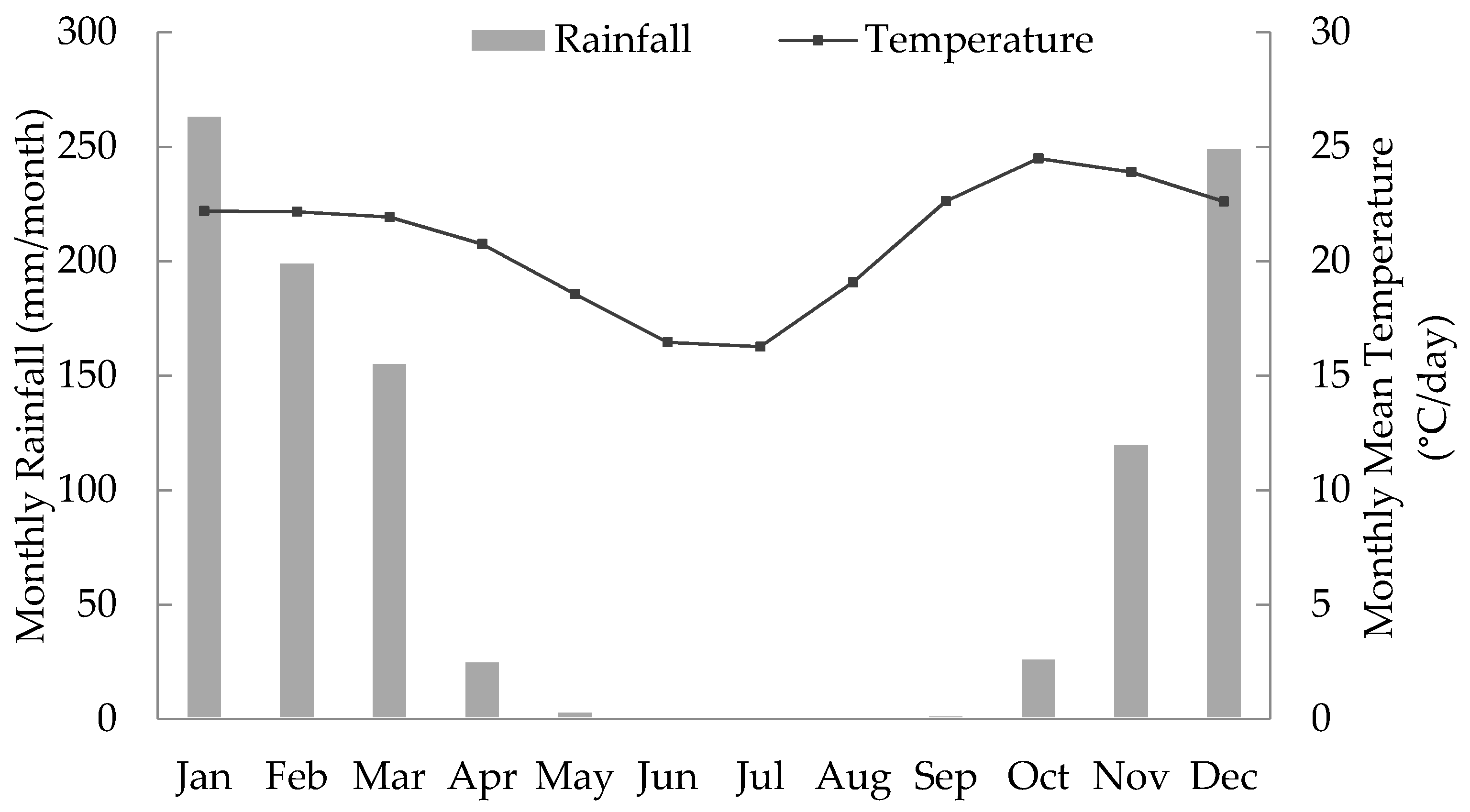
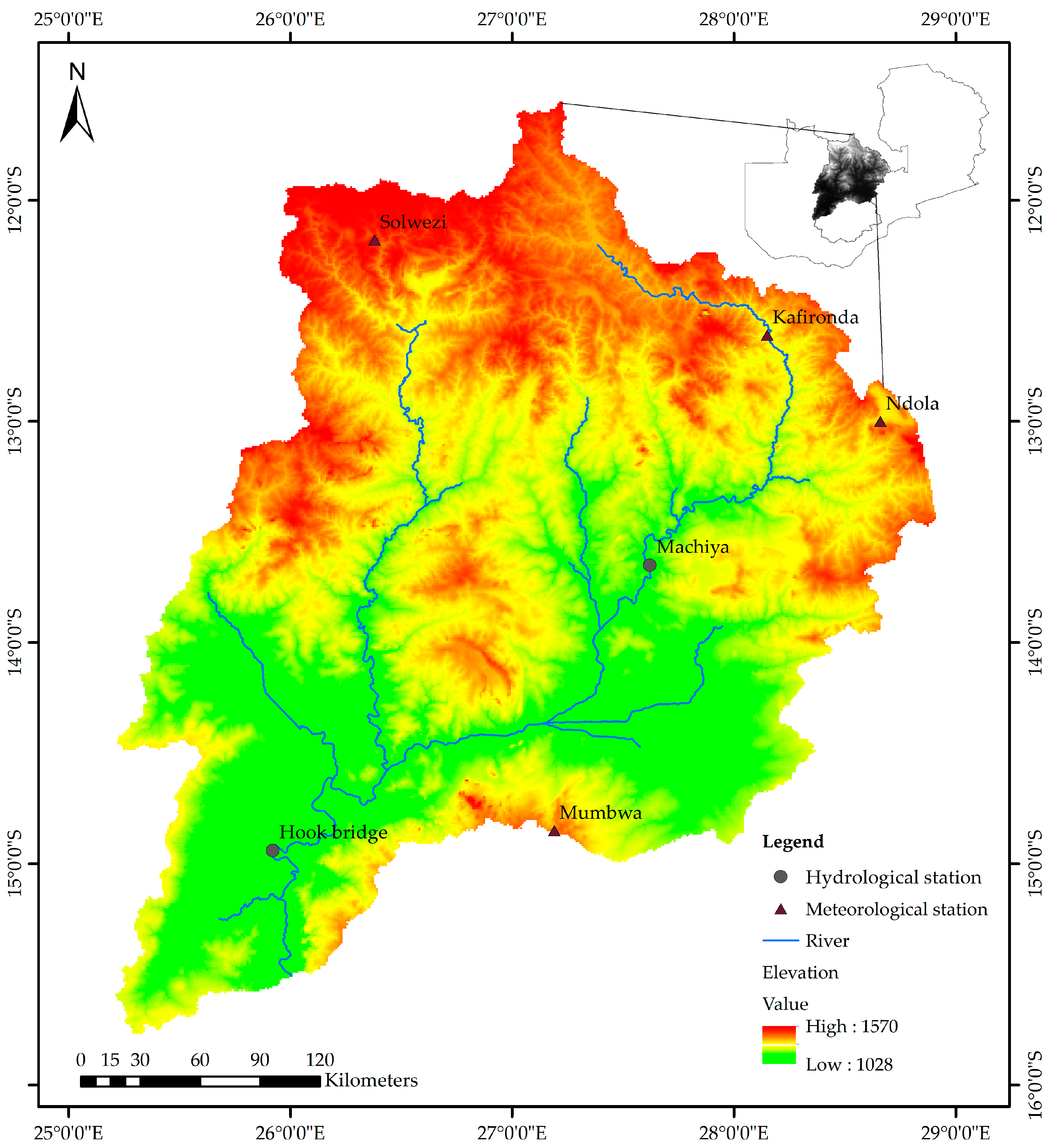
2.1. Study Area
2.2. Sources of Data
2.3. Methodology
2.3.1. Drought Indices
2.3.2. Drought Evaluation
2.3.3. Trend Analysis
2.3.4. SWAT Model
3. Results
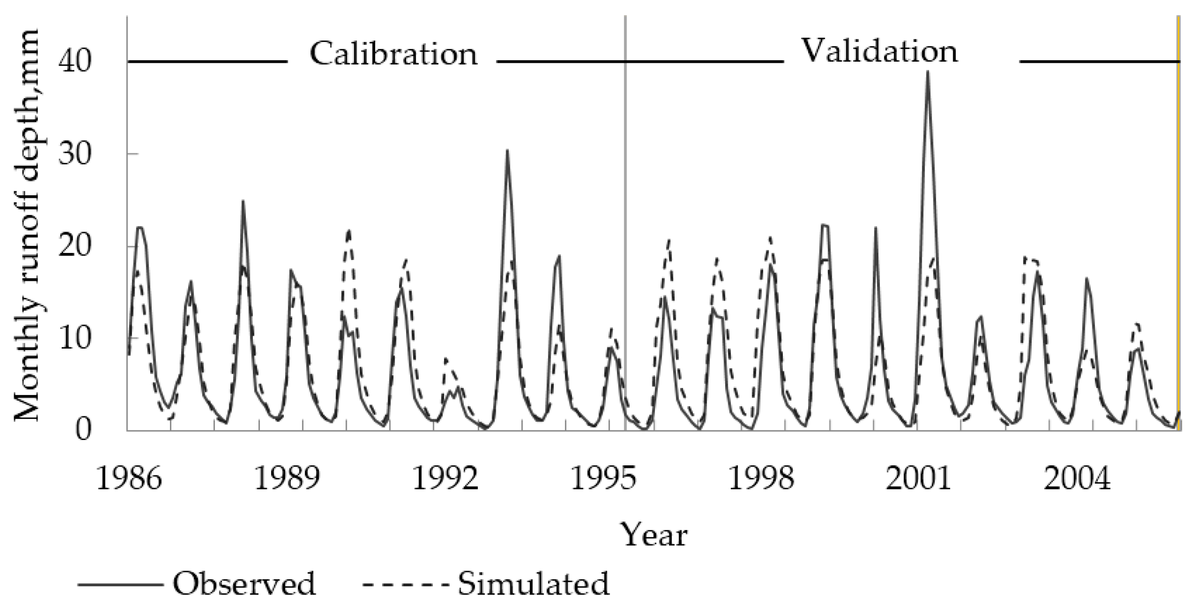
3.1. Applicability of SWAT Model
3.2. Temporal Analysis of Droughts
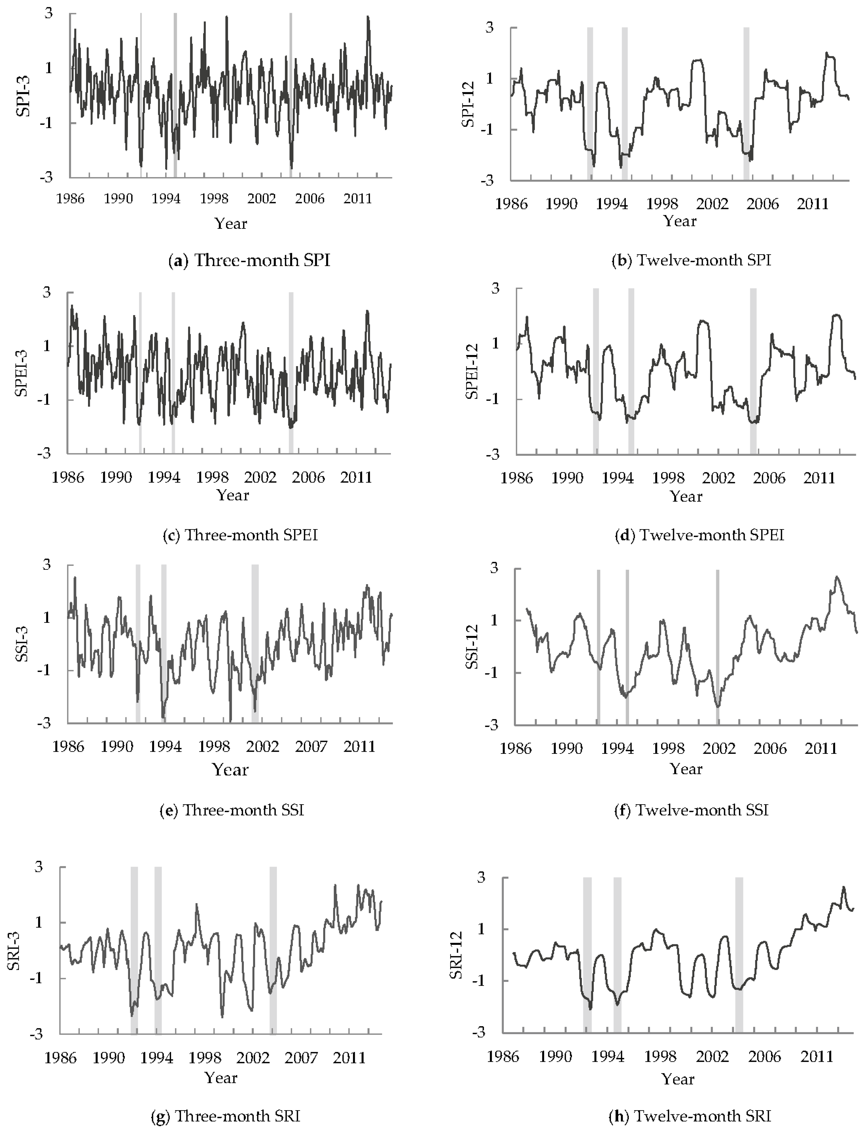
3.2.1. Identification of Historical Droughts Based on Different Indices
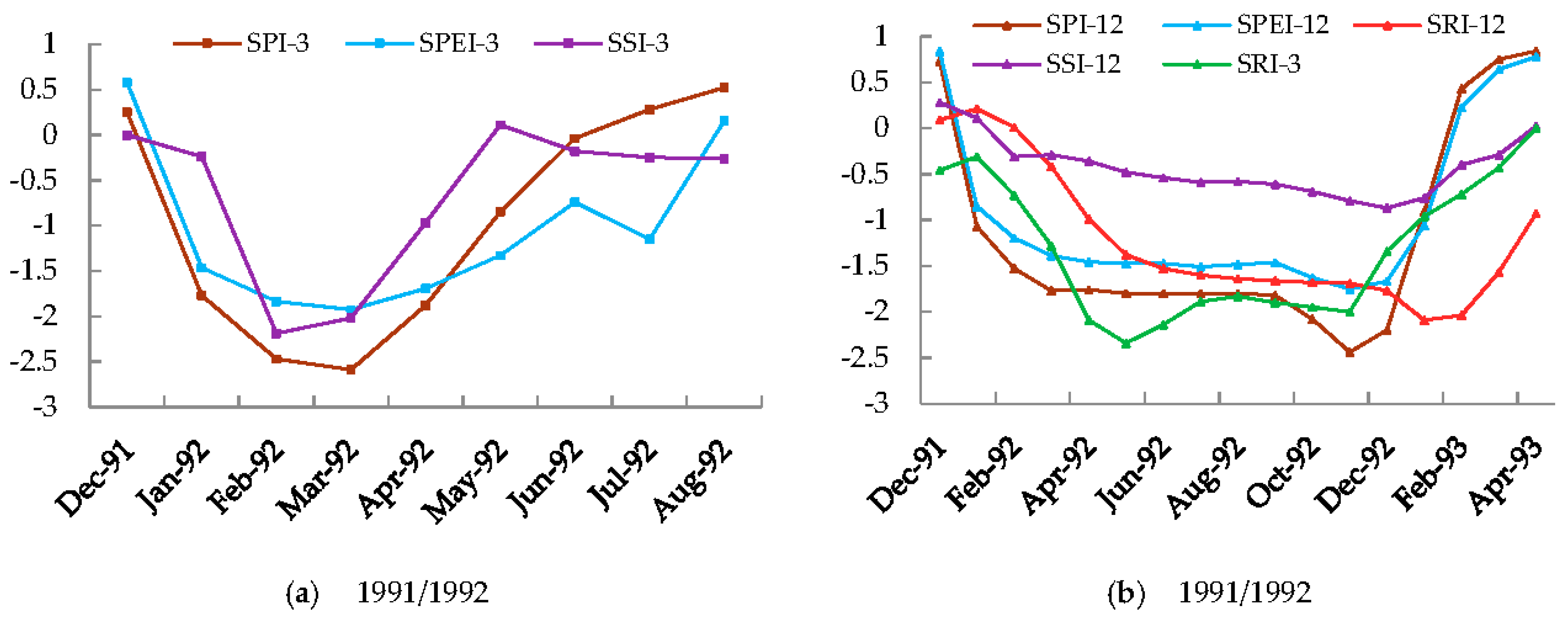
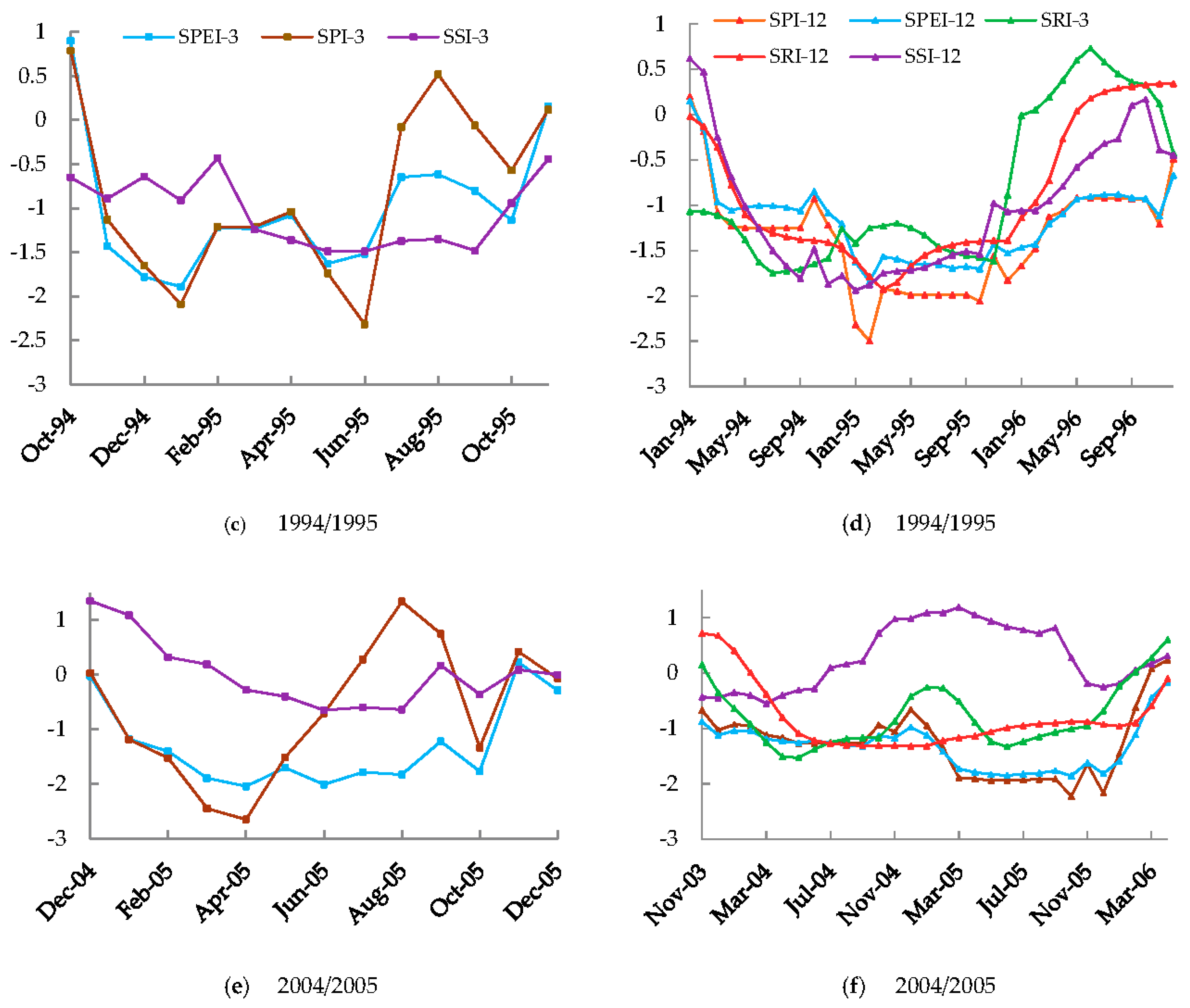
3.2.2. Evolution of Drought Indices for Major Droughts
3.3. Drought Duration, Intensity and Frequency
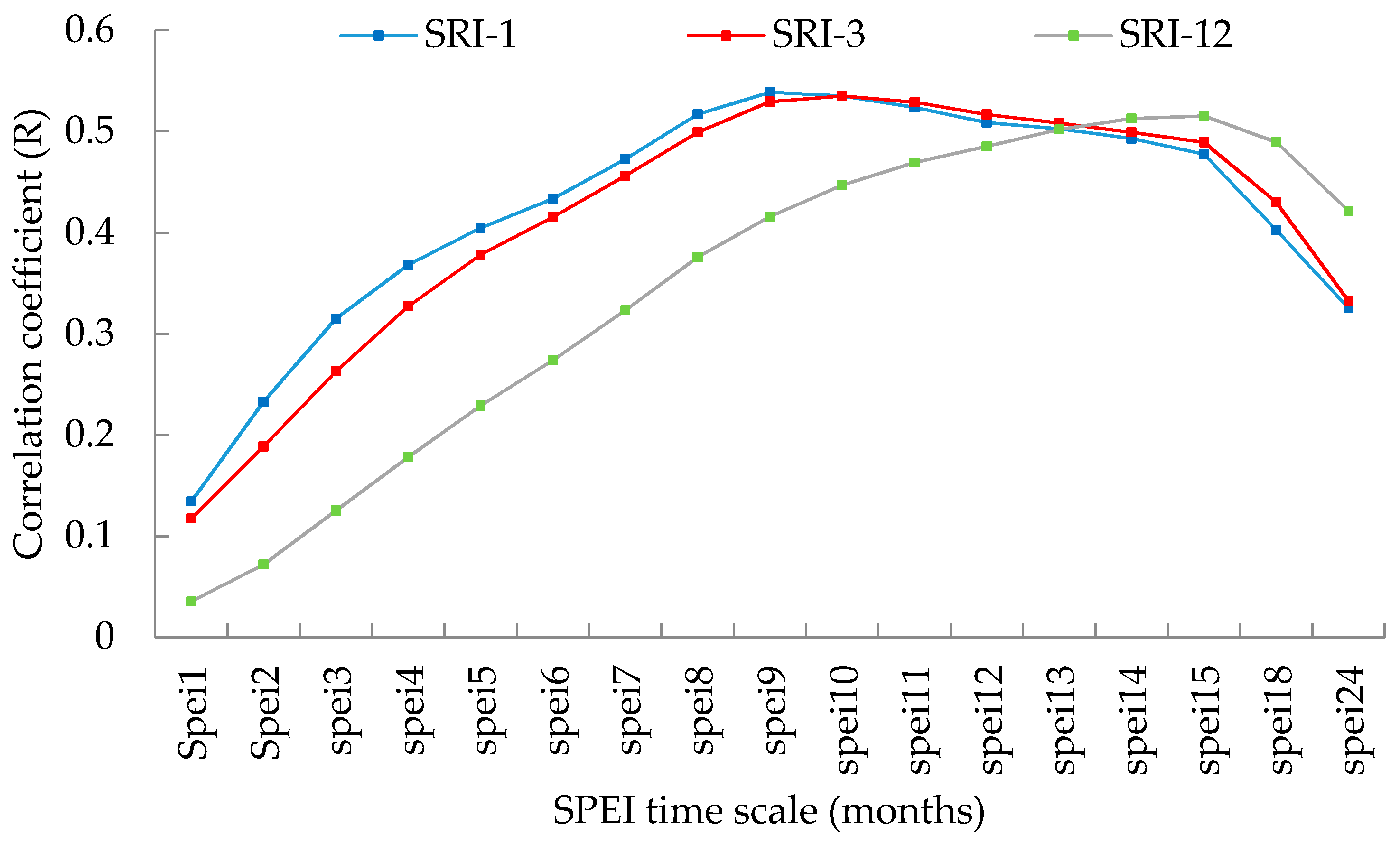
3.4. Trend Analysis and Correlation between Meteorological and Hydrological Drought Indices
4. Discussion
4.1. Performance of Indices
4.2. Characteristics of Droughts
5. Conclusions
Acknowledgments
Author Contributions
Conflicts of Interest
References
- Wilhite, D.A. Drought as a Natural Hazard: Concepts and Definitions. In Drought: A Global Assessment; Wilhite, D.A., Ed.; Routledge: London, UK, 2000. [Google Scholar]
- United Nations Framework Convention on Climate Change (UNFCCC). Climate Change: Impacts, Vulnerabilities, and Adaptation in Developing Countries; United Nations Framework Convention on Climate Change: Bonn, Germany, 2007. [Google Scholar]
- Solomon, S.; Qin, D.; Manning, M.; Chen, Z.; Marquis, M.; Averyt, K.B.; Tignor, M.; Miller, H.L. Climate Change 2007—The Physical Science Basis: Working Group I Contribution to the Fourth Assessment Report of the IPCC; Cambridge University Press: Cambridge, UK, 2007; Volume 4. [Google Scholar]
- Guido, Z.; Hill, D.; Crimmins, M.; Ferguson, D. Informing Decisions with a Climate Synthesis Product: Implications for Regional Climate Services. Weather Clim. Soc. 2013, 5, 83–92. [Google Scholar] [CrossRef]
- Wilhite, D. Drought Monitoring and Early Warning: Concepts, Progress and Future Challenges; World Meteorological Organization (WMO): Geneve, Switzerland, 2006. [Google Scholar]
- Steinemann, A.C.; Cavalcanti, L.F. Developing Multiple Indicators and Triggers for Drought Plans. J. Water Resour. Plan. Manag. 2006, 132, 164–174. [Google Scholar] [CrossRef]
- Wilhite, D.A.; Svoboda, M.D.; Hayes, M.J. Understanding the complex impacts of drought: A key to enhancing drought mitigation and preparedness. Water Resour. Manag. 2007, 21, 763–774. [Google Scholar] [CrossRef]
- Heim, R.R., Jr. A review of twentieth-century drought indices used in the United States. Bull. Am. Meteorol. Soc. 2002, 83, 1149. [Google Scholar]
- Wilhite, D.A.; Glantz, M.H. Understanding: The drought phenomenon: The role of definitions. Water Int. 1985, 10, 111–120. [Google Scholar] [CrossRef]
- Vidal, J.; Martin, E.; Franchistéguy, L.; Habets, F.; Soubeyrux, J.M.; Balnchard, M.; Baillon, M. Multilevel and multiscale drought reanalysis over France with the Safran-Isba-Modcou hydrometeorological suite. Hydrol. Earth Syst. Sci. Discuss. 2010, 14, 459–478. [Google Scholar] [CrossRef]
- Tong, R. Regional drought assessment using a distributed hydrological model coupled with Standardized Runoff Index. Proc. Int. Assoc. Hydrol. Sci. 2015, 368, 397–402. [Google Scholar]
- Kamali, B.; Abbaspour, K.C.; Lehmann, A.; Wehrli, B.; Yang, H. Identification of spatiotemporal patterns of biophysical droughts in semi-arid region: A case study of the Karkheh river basin in Iran. Hydrol. Earth Syst. Sci. 2015, 12, 5187–5217. [Google Scholar] [CrossRef]
- McKee, T.B.; Doesken, N.J.; Kleist, J. The relationship of drought frequency and duration to time scales. In Proceedings of the 8th Conference on Applied Climatology, 17–22 January 1993; American Meteorological Society: Boston, MA, USA, 1993. [Google Scholar]
- Vicente-Serrano, S.M.; Beguería, S.; López-Moreno, J.I. A multiscalar drought index sensitive to global warming: The standardized precipitation evapotranspiration index. J. Clim. 2010, 23, 1696–1718. [Google Scholar] [CrossRef]
- Palmer, W.C. Meteorological Drought; US Department of Commerce, Weather Bureau: Washington, DC, USA, 1965; Volume 30.
- Nam, W.-H.; Choi, J.Y.; Yoo, S.H.; Jang, M.W. A decision support system for agricultural drought management using risk assessment. Paddy Water Environ. 2012, 10, 197–207. [Google Scholar] [CrossRef]
- Tsakiris, G.; Vangelis, H. Establishing a drought index incorporating evapotranspiration. Eur. Water 2005, 9, 3–11. [Google Scholar]
- Shukla, S.; Wood, A.W. Use of a standardized runoff index for characterizing hydrologic drought. Geophys. Res. Lett. 2008, 35. [Google Scholar] [CrossRef]
- Shitumbanuma, V. What has happened to Climate in Zambia in Recent Decades. In Proceedings of the 3rd SADC EU International Scientific Symposium-Towards Meeting the Challenges of Climate Change: Institutional Structure and Best Practices in Land and Water Management in Southern Africa, Lusaka, Zambia, 26 May 2008. [Google Scholar]
- Howard, G.W.; Williams, G.J. Proceedings of the National Seminar on Environment and Change: The Consequences of Hydroelectric Power Development on the Utilization of the Kafue Flats, Lusaka, April 1978; Kafue Basin Research Committee of the University of Zambia: Lusaka, Zambia, 1982. [Google Scholar]
- Schelle, P.; Pittock, J. Restoring the Kafue Flats: A partnership approach to environmental flows in Zambia. In Proceedings of the Eighth International River Symposium, Brisbane, Australia, 5–9 September 2005. [Google Scholar]
- Burke, J.J. Approaches to integrated water resource development and management. Natl. Resour. Forum 1994. [Google Scholar] [CrossRef]
- Fischer, G.; Shah, M.M.; van Velthuizen, H. Climate Change and Agricultural Vulnerability; IIASA Publications: Vienna, Austria, 2002. [Google Scholar]
- Sivapalan, M. IAHS Decade on Predictions in Ungauged Basins (PUB) 2003–2012: PUB Science and Implementation Plan. Hydrol. Sci. J. 2003, 48, 857–880. [Google Scholar] [CrossRef]
- Sichingabula, H.M. Rainfall variability, drought and implications of its impacts on Zambia, 1886–1996. IAHS Publ. 1998, 252, 125–134. [Google Scholar]
- Muchinda, M. Drought Incidence in Zambia over the Thirty-Year Period 1979/71-1999/2000. In Proceedings of the Second International Conference on Tropical Climatology, Meteorology and Hydrology, Brussels, Belgium, 13–14 December 2001; Royal Meteorological Institue of Belgium: Brussels, Belgium, 2004. [Google Scholar]
- Jain, S. An Empirical Economic Assessment of Impacts of Climate Change on Agriculture in Zambia; World Bank Policy Research Working Paper, No. 4291; World Bank: Washington, DC, USA, 2007. [Google Scholar]
- Lekprichakul, T. Impact of 2004. 2005 Drought on Zambia’s Agricultural Production and Economy: Preliminary Results (Working Paper on Social-Ecological Resilience Series No. 2008-002); Research Institute for Humanity and Nature: Kyoto, Japan, 2008. [Google Scholar]
- Sichingabula, H.M.; Sikazwe, H. Occurrence, seventy and magnitude of hydrological drought in Zambia: Impacts and implications. Hydrol. Extremes Underst. Predict. Mitigating 1999, 255, 297–305. [Google Scholar]
- Obrdlik, P.; Mumeka, A.; Kasonde, J. Regulated rivers in Zambia—The case study of the Kafue river. Regul. Rivers Res. Manag. 1989, 3, 371–380. [Google Scholar] [CrossRef]
- Mwelwa, E.M. The Application of the Monthly Time Step Pitman Rainfall-Runoff Model to the Kafue River Basin of Zambia; Rhodes University: Grahamstown, South Africa, 2004. [Google Scholar]
- Mambwe, S.H.; Sikatali, C. Mineralisation and Potential of the Gemstone Industry of Zambia; British Geological Survey: Keyworth, UK, 1994. [Google Scholar]
- Aregheore, E.M. Country Pasture/Forage Resource Profiles: Zambia; FAO: Rome, Italy, 2009. [Google Scholar]
- Sheriza, M.; Ainuddin, N.A.; Hazandy, A.H.; Zulhaidi, M.S.H. Annual rainfall estimation based on two different methods. J. Environ. Hydrol. 2011, 19, 1–9. [Google Scholar]
- Jarvis, A.; Reuter, H.I.; Nelson, A.; Guevara, E. Hole-Filled SRTM for the Globe Version 4. CGIAR-CSI SRTM 90 m Database 2008. Available online: http://srtm.csi.cgiar.org (accessed on 25 March 2017).
- Sanchez, P.A.; Ahamed, S.; Carré, F.; Hartemink, A.E.; Hempel, J.; Huising, J.; Lagacherie, P.; McBratney, A.B.; McKenzie, N.J.; de Lourdes, M.; et al. Digital soil map of the world. Science 2009, 325, 680–681. [Google Scholar] [CrossRef] [PubMed]
- Svoboda, M.; Hayes, M.; Wood, D. Standardized Precipitation Index User Guide; World Meteorological Organization: Geneva, Switzerland, 2012. [Google Scholar]
- Hayes, M.J.; Svoboda, M.D.; Wilhite, D.A.; Vanyarkho, O.V. Monitoring the 1996 drought using the standardized precipitation index. Bull. Am. Meteorol. Soc. 1999, 80, 429. [Google Scholar] [CrossRef]
- Potop, V.; Boroneanţ, C.; Možný, M.; Štěpánek, P.; Skalák, P. Observed spatiotemporal characteristics of drought on various time scales over the Czech Republic. Theor. Appl. Climatol. 2014, 115, 563–581. [Google Scholar] [CrossRef]
- Guttman, N.B. On the sensitivity of sample L moments to sample size. J. Clim. 1994, 7, 1026–1029. [Google Scholar] [CrossRef]
- Yevjevich, V.M. An Objective Approach to Definitions and Investigations of Continental Hydrologic Droughts; Hydrology Papers (Colorado State University), No. 23; Colorado State University: Fort Collins, CO, USA, 1967. [Google Scholar]
- Helsel, D.R.; Hirsch, R.M. Statistical Methods in Water Resources; Elsevier: Amsterdam, The Netherlands, 1992; Volume 49. [Google Scholar]
- Yue, S.; Pilon, P.; Cavadias, G. Power of the Mann–Kendall and Spearman’s rho tests for detecting monotonic trends in hydrological series. J. Hydrol. 2002, 259, 254–271. [Google Scholar] [CrossRef]
- Yue, S.; Wang, C.Y. Applicability of prewhitening to eliminate the influence of serial correlation on the Mann-Kendall test. Water Resour. Res. 2002, 38. [Google Scholar] [CrossRef]
- Bayazit, M.; Önöz, B. To prewhiten or not to prewhiten in trend analysis? Hydrol. Sci. J. 2007, 52, 611–624. [Google Scholar] [CrossRef]
- Von Storch, H. Misuses of statistical analysis in climate research. In Analysis of Climate Variability; Springer: Berlin/Heidelberg, Germany, 1999; pp. 11–26. [Google Scholar]
- Arnold, J.G.; Srinivasan, R.; Muttiah, R.S.; Williams, J.R. Large area hydrologic modeling and assessment part I: Model development. J. Am. Water Resour. Assoc. 1998, 34, 73–89. [Google Scholar] [CrossRef]
- Abbaspour, K.; Vejdani, M.; Haghighat, S. SWAT-CUP Calibration and Uncertainty Programs for SWAT. MODSIM 2007 International Congress on Modelling and Simulation, Modelling and Simulation Society of Australia and New Zealand. 2007. Available online: https://www.researchgate.net/publication/266215018_SWAT-CUP_calibration_and_uncertainty_programs_for_SWAT (accessed on 30 March 2017).
- Krause, P.; Boyle, D.; Bäse, F. Comparison of different efficiency criteria for hydrological model assessment. Adv. Geosci. 2005, 5, 89–97. [Google Scholar] [CrossRef]
- Moriasi, D.N.; Arnold, J.G.; Van Liew, M.W.; Bingner, R.L.; Harmel, R.D.; Veith, T.L. Model evaluation guidelines for systematic quantification of accuracy in watershed simulations. Trans. ASABE 2007, 50, 885–900. [Google Scholar] [CrossRef]
- Thurlow, J.; Zhu, T.; Diao, X. The Impact of Climate Variability and Change on Economic Growth and Poverty in Zambia; IFPRI Discussion Paper 00890; IFPRI: Washington, DC, USA, 2009. [Google Scholar]
- Trambauer, P.; Maskey, S.; Werner, M.; Pappenberger, F.; Van Beek, L.P.H.; Uhlenbrook, S. Identification and simulation of space-time variability of past hydrological drought events in the Limpopo River basin, southern Africa. Hydrol. Earth Syst. Sci. 2014, 18, 2925–2942. [Google Scholar] [CrossRef]
- Vogel, C.; Koch, I.; van Zyl, K. “A Persistent Truth”-Reflections on Drought Risk Management in Southern Africa. Weather Clim. Soc. 2010, 2, 9–22. [Google Scholar] [CrossRef]
- Hulme, M. Climate Change and Southern Africa: An Exploration of Some Potential Impacts and Implications for the SADC Region; Climatic Research Unit, University of East Anglia: Norwich, UK, 1996. [Google Scholar]
- Gannon, C.; Kandy, D.; Turner, J.; Kumar, I.; Pilli-Sihvola, K.; Chanda, F.S. Nearterm Climate Change in Zambia; Red Cross/Red Crescent Climate Centre: The Hague, The Netherlands, 2014. [Google Scholar]
- Haslinger, K.; Koffler, D.; Schöner, W.; Laaha, G. Exploring the link between meteorological drought and streamflow: Effects of climate-catchment interaction. Water Resour. Res. 2014, 50, 2468–2487. [Google Scholar] [CrossRef]
- Vicente-Serrano, S.M.; López-Moreno, J.I. Hydrological response to different time scales of climatological drought: An evaluation of the Standardized Precipitation Index in a mountainous Mediterranean basin. Hydrol. Earth Syst. Sci. 2005, 9, 523–533. [Google Scholar] [CrossRef]
- Zhao, L.; Wu, J.; Fang, J. Robust Response of Streamflow Drought to Different Timescales of Meteorological Drought in Xiangjiang River Basin of China. Adv. Meteorol. 2016, 2016, 1634787. [Google Scholar] [CrossRef]
- Xuchun, Y.; Li, X.; Xu, C.Y.; Zhang, Q. Similarity, difference and correlation of meteorological and hydrological drought indices in a humid climate region–the Poyang Lake catchment in China. Hydrol. Res. 2016, 47, 1211–1223. [Google Scholar]


| Station Name | Latitude (° S) | Longitude (° E) | Precipitation | Temperature |
|---|---|---|---|---|
| Kafironda | −12.61 | 28.15 | 0.92 | 0.96 |
| Mumbwa | −15.08 | 27.19 | 0.92 | 0.99 |
| Ndola | −12.99 | 28.66 | 0.93 | 0.98 |
| Solwezi | −12.17 | 26.37 | 0.91 | 0.97 |
| Drought Categories | SPI, SPEI, SSI, SRI Values |
|---|---|
| Normal | >−0.50 |
| Mild drought | (−1.00, −0.50] |
| Moderate drought | (−1.50, −1.00] |
| Severe drought | (−2.00, −1.5] |
| Extreme drought | ≤−2.00 |
| Simulation | Hook Bridge | Machiya | ||||
|---|---|---|---|---|---|---|
| Daily | Monthly | Monthly | ||||
| Calibration | 0.70 | 0.70 | 0.75 | 0.75 | 0.71 | 0.71 |
| Validation | 0.66 | 0.67 | 0.77 | 0.78 | 0.86 | 0.86 |
| Categories | SPI-3 | SPI-12 | SPEI-3 | SPEI-12 | SSI-3 | SSI-12 | SRI-3 | SRI-12 |
|---|---|---|---|---|---|---|---|---|
| Extreme drought | 1991/1992, 1994/1995, 2004/2005 | 1991/1992, 1994/1995, 2004/2005 | 2004/2005 | None | 1991/1992, 1994/1995, 2000–2003 | 2000–2004 | 1991/1992, 1999/2000, 2001/2002 | 1992/1993 |
| Severe drought | 1990,1998/1999, 2002/2003 | None | 1990/1991, 1991/1992, 1993–1996, 1998/1999, 2001/02 | 1991/1992, 1994–1996, 2002–2006 | 1998 | 1994/1995 | 1994/1995, 2004/2005 | 1994/1995, 2000/2001, 2002/2003 |
| Moderate drought | 1993, 2003/2004, 2008/2009, 2013 | 1987/1988, 2008/2009 | 2003/2004, 2008/2009, 2013 | 2008/2009 | 1986/1987, 1988–1990, 2007/2008 | 1998/1999 | None | 2004/2005 |
| Mild drought/Normal | Other seasons | Other seasons | Other seasons | Other seasons | Other seasons | Other seasons | Other seasons | Other seasons |
| Description | SPI-3 | SPEI-3 | SSI-3 | SRI-3 | SPI-12 | SPEI-12 | SSI-12 | SRI-12 |
|---|---|---|---|---|---|---|---|---|
| Average drought duration (month) | 5 | 8 | 13 | 19 | 24 | 29 | 31 | 22 |
| Minimum duration (month) | 2 | 2 | 4 | 12 | 10 | 12 | 13 | 15 |
| Maximum duration (month) | 8 | 19 | 32 | 26 | 49 | 55 | 51 | 28 |
| Mean drought intensity | 0.92 | 1.00 | 1.02 | 1.26 | 1.07 | 1.11 | 1.11 | 1.07 |
| Drought Frequency (%) | 60.0 | 50.0 | 30 | 16.67 | 16.7 | 13.3 | 10.0 | 16.67 |
| Month | SPEI-3 | SPEI-12 | SRI-3 | SRI-12 | ||||
|---|---|---|---|---|---|---|---|---|
| Z | P | Z | P | Z | P | Z | P | |
| January | 1.22 | –0.54 | 1.71 | 1.71 | ||||
| February | −0.24 | –0.66 | 1.61 | 1.47 | ||||
| March | –0.50 | –0.58 | 1.57 | 1.10 | ||||
| April | –1.36 | –0.66 | 1.68 | 1.47 | ||||
| May | –0.82 | –0.58 | 1.63 | 1.85 | ||||
| June | –2.32 | * | –0.43 | 1.41 | 1.94 | |||
| July | –3.35 | –0.58 | 1.37 | 1.94 | ||||
| August | –3.43 | –0.69 | 1.54 | 2.03 | * | |||
| September | –1.96 | * | –0.58 | 1.72 | 2.03 | * | ||
| October | –2.82 | ** | –0.51 | 1.68 | 2.06 | * | ||
| November | 0.71 | –0.39 | 1.57 | 2.13 | * | |||
| December | 1.11 | –0.36 | 2.45 | * | 2.09 | * | ||
| Annual | –2.00 | * | –0.96 | 2.12 | * | 1.41 | ||
| November–April | –0.07 | –0.71 | 2.16 | * | 1.76 | |||
| May–August | –2.98 | ** | –0.62 | 2.03 | * | 2.47 | * | |
| September–October | –2.95 | ** | –0.66 | 2.20 | * | 2.47 | * | |
© 2017 by the authors. Licensee MDPI, Basel, Switzerland. This article is an open access article distributed under the terms and conditions of the Creative Commons Attribution (CC BY) license (http://creativecommons.org/licenses/by/4.0/).
Share and Cite
Lweendo, M.K.; Lu, B.; Wang, M.; Zhang, H.; Xu, W. Characterization of Droughts in Humid Subtropical Region, Upper Kafue River Basin (Southern Africa). Water 2017, 9, 242. https://doi.org/10.3390/w9040242
Lweendo MK, Lu B, Wang M, Zhang H, Xu W. Characterization of Droughts in Humid Subtropical Region, Upper Kafue River Basin (Southern Africa). Water. 2017; 9(4):242. https://doi.org/10.3390/w9040242
Chicago/Turabian StyleLweendo, Muumbe K., Baohong Lu, Meng Wang, Hanwen Zhang, and Wei Xu. 2017. "Characterization of Droughts in Humid Subtropical Region, Upper Kafue River Basin (Southern Africa)" Water 9, no. 4: 242. https://doi.org/10.3390/w9040242
APA StyleLweendo, M. K., Lu, B., Wang, M., Zhang, H., & Xu, W. (2017). Characterization of Droughts in Humid Subtropical Region, Upper Kafue River Basin (Southern Africa). Water, 9(4), 242. https://doi.org/10.3390/w9040242