Article

Long-Term Managed Aquifer Recharge in a Saline-Water Aquifer as a Critical Component of an Integrated Water Scheme in Southwestern Florida, USA

1
U.A. Whitaker College of Engineering, Florida Gulf Coast University, 10501 FGCU Boulevard South, Fort Myers, FL 33965-6565, USA
2
Groundwater Tek, Inc., 14542 Indigo Lakes Circle, Naples, FL 34119, USA
3
Emergent Technology Institute, U.A. Whitaker College of Engineering, Florida Gulf Coast University, 16301 Innovation Lane, Fort Myers, FL 33913, USA
4
WSP, 1567 Hayley Lane, Suite 202, Fort Myers, FL 33907, USA
*
Author to whom correspondence should be addressed.
Water 2017, 9(10), 774; https://doi.org/10.3390/w9100774
Submission received: 25 August 2017 / Revised: 25 September 2017 / Accepted: 3 October 2017 / Published: 11 October 2017
(This article belongs to the Special Issue Aquifer Storage and Recovery: Theory, Design, and Operation)

Abstract

:
Managed Aquifer Recharge (MAR) systems can be used within the context of integrated water management to create solutions to multiple objectives. Southwestern Florida is faced with severe environmental problems associated with the wet season discharge of excessive quantities of surface water containing high concentrations of nutrients into the Caloosahatchee River Estuary and a future water supply shortage. A 150,000 m3/day MAR system is proposed as an economic solution to solve part of the environmental and water supply issues. Groundwater modeling has demonstrated that the injection of about 150,000 m3/day into the Avon Park High Permeable Zone will result in the creation of a 1000 m wide plume of fresh and brackish-water (due to mixing) extending across the water short area over a 10-year period. The operational cost of the MAR injection system would be less than $0.106/m3 and the environmental benefits would alone more than cover this cost in the long term. In addition, the future unit water supply cost to the consumer would be reduced from $1 to $1.25/m3 to $0.45 to $0.65/m3.

1. Introduction

Southern Florida is a subtropical region which receives an average of nearly 1320 mm/year of rainfall, but experiences numerous water-supply problems related to high population growth in the coastal areas, limited fresh groundwater sources, and considerable variation in annual rainfall [1]. There are conflicts concerning the use of freshwater resources ranging from impacts to wetlands to disputes between agricultural and municipal water users over the responses to the common occurrences of droughts that create temporary water-supply shortages [2,3,4]. While the region receives abundant rainfall, the distribution of rainfall, both temporally and spatially, provides water-supply challenges in many specific locations.
Lake Okeechobee is currently being used as a storage and flood control basin for a large portion of southern Florida (Figure 1). The lake is very large with an area of about 1900 km2 during the high stage, which can decline to 1450 km2 [5] during the low stage. It has an average depth of only 3.7 m [6]. The lake is surrounded by a muck dike originally constructed in 1937, called the Hoover Dike, which was enlarged between 1960 and 1970 [7] and is currently undergoing modifications to increase its strength, which should be completed by 2020 [8].
Lake Okeechobee is managed by the U.S. Army Corp of Engineers (USCOE) and the South Florida Water Management District (SFWMD) at elevations ranging from about 4 to 5 m above sea level (National Geodetic Vertical Datum of 1929; NGVD). High rates of rainfall and surface-water runoff from the Kissimmee River/canal, Fisheating Creek, Taylor Creek, and Nubbin Slough have caused large increases in the lake stage which have threatened to cause the failure of the Hoover Dike by head breach or a hurricane-induced storm surge [8,9,10]. During high water periods, the lake stage is managed by controlled discharges of water to the Caloosahatchee River to the west and the St. Lucie Canal/River to the east, along with some discharge to the south into storm-water treatment areas and water conservation areas. The high rates of discharge and accompanying high nutrient loads into the Caloosahatchee and St. Lucie rivers have adversely affected estuarine areas [11]. It is therefore a water management goal in the region to reduce the discharge of excess freshwater into the estuarine areas during periods of high stages of Lake Okeechobee. Completion of the strengthening of the Hoover Dike and the construction of a new reservoir may be able to create some additional storage to lessen the magnitude of the discharges, but will still not accomplish the entire goal. Based on the future need for additional water supplies, some of the excess water could be placed into aquifer storage for future beneficial use for specific downstream users adjacent to the river.
Some high growth areas occur near the Caloosahatchee River where both freshwater and brackish water resources are inadequate, such as Lehigh Acres, which is located in Lee County (Figure 2). This poorly-designed urban subdivision has a land area of about 246 km2 and had a population of 86,784 in the 2010 US Census [12,13]. The buildout population, based on the number of platted lots and other considerations, is roughly projected to be 300,000 in about 2060 [12]. The development currently has a small-capacity central utility that could provide up to 16,000 m3/day of potable water [14]. In 2014, the water use was about 10,600 m3/day [14]. Water supply for the Lehigh Acres area will require an estimated 492 L/day/person based on the average consumption in the area, along with commercial, landscape (common grounds), and recreational irrigation water uses.
Potable and non-potable water use in most of Lehigh Acres occurs through the use of private wells, mostly tapping the Sandstone Aquifer [15]. The Sandstone Aquifer begins at between 10 to 30 m below the land surface and has a thickness ranging from 20 to 50 m. The current number of small-diameter Sandstone Aquifer wells in the Lehigh Acres area is estimated to be greater than 12,000. The Sandstone Aquifer is also used to supply the small central utility system and numerous agricultural users present throughout the surrounding area [16]. At the current time, the potentiometric surface of the Sandstone Aquifer drops more than 10 m below the land surface in a large part of Lehigh Acres [15]. The large seasonal reduction in the potentiometric surface causes the failure of many wells within Lehigh Acres as water levels drop below pump intakes. There is a serious question concerning whether the sustainable yield of the aquifer has already been exceeded. However, as the population continues to grow and more wells are drilled into this over-used aquifer, the sustainable yield will eventually be exceeded with the aquifer being unable to supply new water users.
As an alternative to using surface water directly from the Caloosahatchee River or shallow freshwater aquifers that have a limited capacity, the desalination of brackish groundwater has become common in southwestern Florida and many new facilities are being constructed in southeastern Florida [16]. When the total dissolved solids concentration of the source groundwater is less than about 6000 mg/L, the economics of brackish-water desalination (BWRO) are acceptable and costs to the consumer are not much greater than treated surface water or fresh groundwater, which both tend to have high concentrations of organic compounds that must be removed because they are precursors to the formation of trihalomethanes during disinfection. Typical treatment costs using BWRO desalination range from about $0.45 to $0.65/m3 [17]. However, when the raw water quality creates the necessity to use seawater reverse osmosis (SWRO) desalination, the likely cost will be in the range of $1.00 to $1.30/m3 [17], based on the plant capacity being considered. In addition, the generally low population density in many parts of the area will result in exceptionally high capital costs to construct the transmission lines and pumping stations.
An alternative to the expensive SWRO desalination water-supply solution, could be the development of a long-term managed aquifer recharge system that stores excess flow from the Caloosahatchee River to recharge the Avon Park Permeable Zone (APPZ) with large volumes of freshwater. This system would have two beneficial uses; the removal of excess fresh water from the river that could harm the estuary during high flow periods and as a future public water-supply to reduce the consumer cost and energy consumption. The dual benefits make this solution economically attractive. The purpose of this research effort is to assess this proposed solution in terms of technical feasibility with a comparison of cost effectiveness.

2. Background and Methods

2.1. Hydrogeology of the Deep Saline-Water Aquifer System

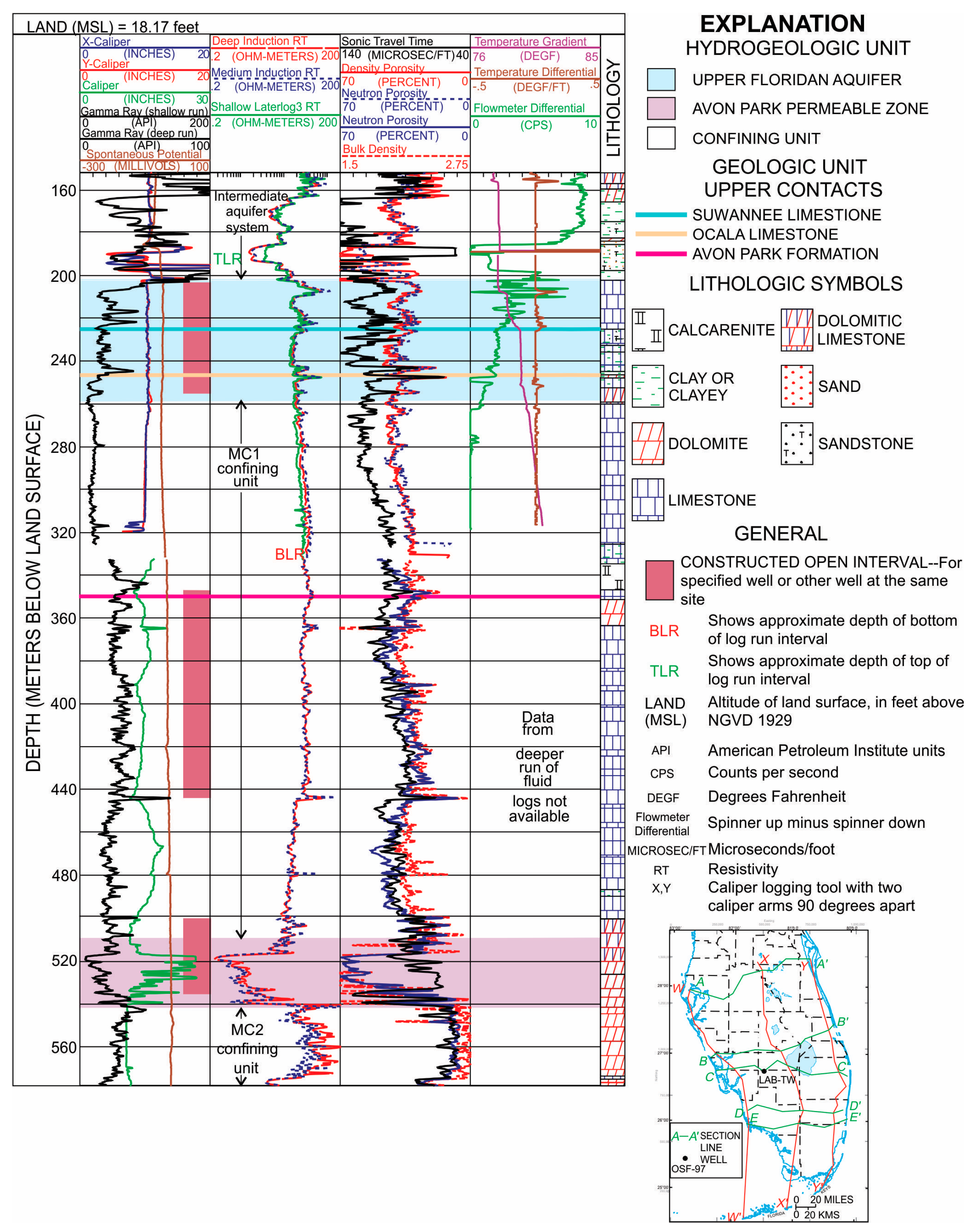
A major consideration in the development of a brackish-water reverse osmosis (BWRO) desalination system is the source of the water and its stability of water quality over time [18]. The Lower Hawthorn and Upper Suwannee aquifers are commonly used to supply raw water to BWRO facilities located in western Lee County [17]. Unfortunately, the productivity of these aquifers declines from west to east, so there appears to be an insufficient quantity of brackish water to reliably meet the long-term future demand in the Lehigh Acres area. The estimated transmissivity of the Lower Hawthorn Aquifer ranges between 373 and 2,150 m2/day in western Lee County [19,20] and declines to between zero and about 124 m2/day in eastern Lee County [19,20]. An U.S. Geological Survey (USGS) investigation for an aquifer storage and recovery project found that the Upper Suwanee Aquifer has a transmissivity range of only 65 to 74 m2/day in eastern Lee County [21]. The Lower Suwannee Aquifer has a transmissivity ranging from 373 to 869 m2/day [20] in western Lee County and also in eastern Lee County, but this is based on few high-quality data and no long-term aquifer performance tests [20]. Another investigation showed that the transmissivity of the “Upper Floridan Aquifer” at a nearby test site, considering sediments lying in the lower part of the Arcadia Formation, the Suwannee Formation, and the upper part of the Ocala Limestone, was about 845 m2/day [22,23] (Figure 3). Based on these values, the possibility of obtaining a stable source of raw water for a large BWRO facility in Lehigh Acres is questionable, especially when the gross capacity required will be about 216,250 m3/day based on the demand at 173,000 m3/day with a recovery efficiency of 80%.
A sufficient supply of raw water could be developed within the Avon Park Permeable zone which lies between 511 and 542 m below the surface (Figure 3) [22,23]. While the transmissivity of the aquifer is estimated to average about 46,000 m2/day, which is high, the water quality is quite saline with a total dissolved solids (TDS) concentration of 18,000 mg/L [22]. Therefore, a seawater desalination plant would be required to treat this water and would have a required total raw water capacity wellfield of about 288,333 m3/day based on a 60% recovery efficiency. The estimated treatment cost for this water would be about $1.00–1.20/m3 [17].

2.2. Future Water Use Assessment in Lehigh Acres

The buildout population based on the number of platted lots and other considerations is roughly projected to be 300,000 in about 2060 [12]. The potable water demand for municipal supply at buildout will be about 148,000 m3/day for the residential component, with an additional 25,000 m3/day for commercial and industrial uses and about 20,000 m3/day for various common landscape and recreational uses for a total of about 193,000 m3/day. This estimate may vary plus or minus 20% depending on the size and value of future housing and on possible re-development schemes being considered now and other plans that will be developed in the future.

2.3. Description of Scheme to Store Excess Fresh Surface Water in Saline-Water Aquifers

The Lehigh Acres urban area is located close to a surface-water reservoir/treatment area, known as the Caloosahatchee River (C-43) West Basin Storage Reservoir (location in Figure 4 south of 80 below the two red dots). This 43.3 km2 facility will store up to 6.88 × 10⁸ m3 of freshwater that will be diverted into it during wet periods [24]. The dual purpose of the impoundment is to treat the water from the Caloosahatchee River to remove nutrients and to regulate flow into the Caloosahatchee River Estuary [24]. The impoundment could also provide storage and initial treatment for water to be injected into the Avon Park Permeable Zone. Water from the reservoir would be injected after some degree of treatment to reduce the potential for aquifer clogging and to meet the regulatory standards under the federal and state Underground Injection Control (UIC) Program [25].
Groundwater flow in all aquifers within the Floridan Aquifer System generally moves from east to west in western Hendry County, which would be from the reservoir site into the Lehigh Acres geographic area [26]. Therefore, the aquifer storage scheme would contain a series of MAR wells located in a north-south direction, beginning about 8 km south of State Road 82 and extending for about 1000 m to the south. As a conceptual design, the injection wells would be located 100 m apart and could include up to 10 wells, each with a capacity of between 88 and 132 L/s. The total capacity of the injection system would be up to about 1752 L/s. The system capacity could be increased to provide reduced impacts to the estuary and more freshwater storage At this rate, the wells could be used to remove a significant quantity of freshwater from the reservoir (and the Caloosahatchee River) during wet periods and would also convey a considerable amount of water into storage in the receiving aquifer. It would increase the capacity of the reservoir storage system by about 8%. If high phosphate concentration water could be diverted internally within the reservoir for injection, the environmental benefit of the MAR system would be increased. Depending upon the storage capacity desired for the protection of the Caloosahatchee River Estuary during wet periods, the capacity could be increased by the construction of additional wells, which would provide an even greater benefit to the down-gradient aquifer water users of the future.
The MAR wells could be located either along the Townsend Canal right-of-way or a new right-of-way located along the Lee-Hendry County line. Groundwater modeling can be used to develop an optimization assessment for the location, well spacing, and injection rates. The right-of-way closest to the reservoir would mean that the injected water would have to flow a distance of 1500 m before it would enter the potential use zone in Lehigh Acres.

2.4. Assessment of the Pre-Treatment Requirements for the Freshwater to be Stored

There are two potential strategies that could be used to treat the freshwater before injection into the Avon Park Permeable Zone (APPZ). They include treatment of the water to remove particulates, organic materials, and bacteria to essentially meet drinking water standards or treatment of the water to remove only substances that could potentially clog the aquifer system in the vicinity of the injection wells, but not treat the water to full drinking water standards. Inasmuch as the groundwater in the APPZ contains more than 10,000 mg/L of total dissolved solids, it is not considered by the U.S. Environmental Protection Agency (USEPA) and the Florida Department of Environmental Protection (FDEP) to be an Underground Source of Drinking Water (USDW) [27]. As a non-USDW aquifer, the only applicable water quality criteria for injection is that the injected water not be a hazardous waste (as defined by the USEPA) [28]. Injection into a USDW must not endanger overlying USDW aquifers, with endangerment being considered as causing a violation of a groundwater standard. Two different water treatment schemes have been developed to assess the capital and operating costs for the MAR system.

2.5. Estimation of Capital and Operating Costs Including Pretreatment of the Freshwater to be Injected and the Estimated Cost Benefit of the Estuary Protection Provided by Operation of the System

Cost estimates have been developed to construct and operate water treatment facilities necessary to remove particulate matter from the freshwater in the reservoir. Costs to construct the MAR wells and to operate them have also been developed. These costs include the equipment and facilities to allow back-flushing of the MAR wells to mitigate clogging and to keep them in an operational condition.
There are two financial benefits to the development of this system which include the reduction in the treatment of potable water for use in northeastern Lee County (including Lehigh Acres), and an increase in the operational capacity of the reservoir which will protect the ecology of the Caloosahatchee River Estuary. Some comparative costs have been made for water treatment with and without the development of this MAR system. Also, some environmental economics have been developed for the protection of the estuary, which is a key factor in the long-term economic viability of Lee County which has an economy based primarily on tourism.

2.6. Groundwater Modelling

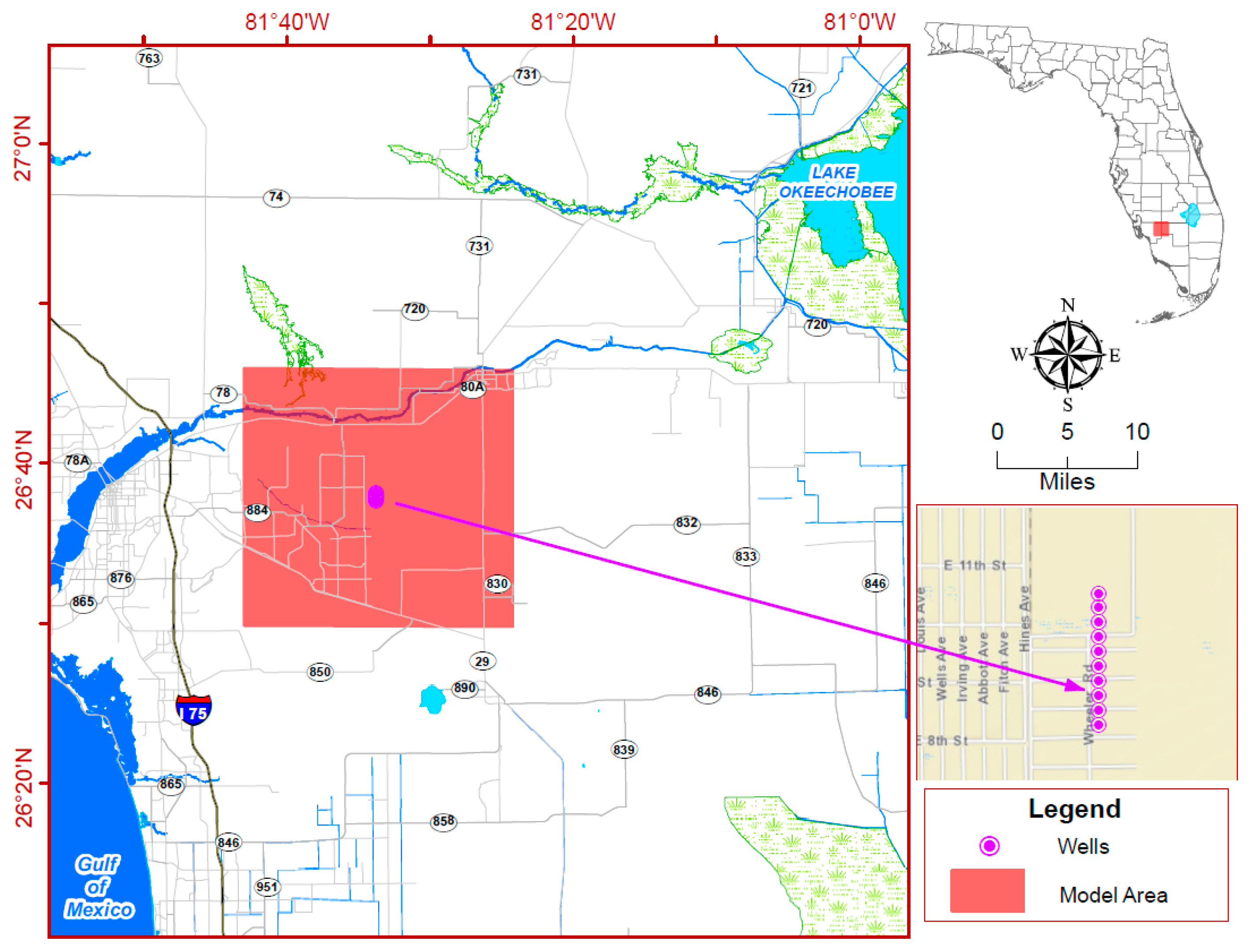
A three-dimensional groundwater flow and solute-transport model was constructed using the SEAWAT code, which generates simulations of variable-density groundwater systems [29,30]. The model has 300 rows and 310 columns. It has a uniform grid spacing of 100 meters in both row and column directions. The model covers an area of 30 km by 31 km (Figure 5). The APPZ in the model is represented by one model layer with a uniform thickness of 31 m, and a depth ranging from 511 m to 542 m below the land surface. A uniform hydraulic conductivity of 1484 m/day is applied to the APPZ model layer, based on the reported value of transmissivity of 46,000 m2/day [22]. The values of the storage coefficient and effective porosity applied are estimated to be 1 × 10⁻⁴ and 0.1, respectively, based on typical values found in the Floridan Aquifer System in this region [20].
Regional groundwater flows from east to west across the site. Based on previous studies, a uniform regional groundwater gradient of 1.9 × 10⁻⁴ was used in this model [26]. There are essentially no data on the hydraulic gradient of the APPZ. Instead, the gradient used is based on the gradients inferred in overlying saline-water aquifers [26]. In this area, the gradient is directed almost east to west. The eastern and western model borders are defined as constant head boundaries. The northern and the southern model borders are defined as no-flow boundaries.
The native water in the aquifer is brackish. The reported value of the total dissolved solids concentration is about 18,000 mg/L at the reservoir site and likely increases toward the west [19,22]. This value is used as the initial concentration in the model.
The longitudinal, transverse, and vertical dispersivity values used in the model are 10 m, 5 m, and 5 m, respectively, which were derived from the literature [31].
A total of 10 injection wells, 100 m apart, were placed within the middle of the model, perpendicular to the regional flow direction. Figure 6 shows the well locations within the modeling grid. The simulated injection rate was 15,142 m3/day per well. A total injection rate of about 151,000 m3/day was simulated for a period of 10 years. The TDS of injected water was assumed to be 100 mg/L.

2.7. Operation of the Reservoir to Maximize the Removal of Harmful Phosphate Concentrations

During certain periods of the year, the discharge of the Caloosahatchee River contains excessive quantities of nutrients, particularly phosphate. Some of the phosphate load is supposed to be removed by aquatic vegetation while the water is stored in the new reservoir. However, the phosphate-laden water and organics could cause periodic algae blooms within the segmented basins of the reservoir, thereby presenting problems with re-integrating the water back into the river during times of need. It may be possible to send the water containing excessive phosphate concentrations to the southern part of the reservoir to be incorporated into the injection water supply for the MAR wells, especially before algal blooms occur. The phosphate would be expected to be largely adsorbed within the aquifer during the transport of the freshwater toward use areas [32,33,34].

3. Results

3.1. Pre-treatment of Surface Water for Aquifer Storage

A key issue during the operation of the MAR wells is the control of clogging during operation. The freshwater entering the reservoir will contain significant concentrations of suspended sediments and organics and there could be periodic algal blooms within the reservoir. Therefore, the water will require filtration to remove the particulates prior to recharge.
Filtration of water for large-scale ASR facilities has been tested for the Everglades Comprehensive Plan at two locations, the Kissimmee River site and the Hillsboro site. The Hillsboro site used a centrifugal filter system which was not successful and did not meet the desired degree of filtration [35]. At the Kissimmee River ASR site, mixed media filtration was employed using a Tonya filter with a filtration rate of 2.1 L/min/m2 of media area at a gross production rate of about 18,940 m3/day [35].
The filtration for the proposed MAR facility will follow a similar strategy to the Kissimmee River ASR facility. The Kissimmee River ASR water treatment facility operated successfully during testing at the desired capacity with minimal difficulty [35]. However, this facility uses a UV disinfection system that has a significant cost of operation. Since the aquifer being used is so deep, very isolated in terms of leakance, and has an initial TDS of 18,000 mg/L, the use of disinfection is unnecessary within the UIC rules. Also, the pressure within the aquifer may impact the longevity of the bacteria, causing short survival times.

3.2. Configuration of Injection and Recovery Wells and Well Design Information

The configuration of the MAR injection wells is a simple alignment running parallel to the Lee-Hendry County line near the west margin of the reservoir (Figure 6). This alignment allows a single, large-diameter pipeline to be used to convey the filtered water to the well heads. The MAR wells are spaced at 100 m increments and 10 wells were modeled with all capacities being 15,152 m3/day each with a total capacity of about 151,515 m3/day.
Recovery wells may be located anywhere within the central part of the created freshwater plume based on the most cost-effective location of a future water treatment plant. The geometry of the down-gradient plume allows many locations to be considered based on the design of the distribution system and the pattern of growth within Lehigh Acres.
Both the injection and production wells will be an open-hole design with the casings seated into the upper part of the aquifer. The injection wells will be fully-penetrating (open through the full aquifer thickness). The recovery wells will be partially-penetrated, using one-third to one-half of the aquifer thickness. This design will allow the recovery of lower salinity water based on the buoyancy of the freshwater as it passes through the aquifer from the injection wells to the recovery wells. Future decisions on the location of the recovery wells will be based not only on the best locations relative to the water treatment plant, but also on the anticipated salinity of the recovered water which may range from fresh to mildly brackish.

3.3. Modeling Results of MAR Scheme

Based on groundwater solute transport modeling of the MAR system for a period of 10 years of continuous operation with two different hydraulic gradient scenarios, the injected plume of freshwater will extend across most of Lehigh Acres (Figure 6). Heads were also calculated within the aquifer from the injection location and downgradient.
The relatively high aquifer transmissivity, low leakance, and limited transverse dispersity in the APPZ causes the geometry of the freshwater plume to have limited spreading and the corridor is similar in width to near the injection area. As illustrated in Figure 6, the plume migrates rapidly downgradient and after 10 years traverses a major portion of the land area of Lehigh Acres. This geometry is quite favorable for the future development of a recovery wellfield anywhere along the plume.
Since the leakance of the APPZ in so low, the issue of the forced upward movement of saline water into an overlying aquifer is not a significant issue based on the modeling. Nevertheless, monitoring wells within the APPZ and the overlying aquifer would likely be required by the FDEP.

3.4. Estimated Costs of Long-Term MAR Scheme

3.4.1. Capital Cost of MAR Injection Well and Pretreatment System

The capital costs for the construction of the MAR injection wells and associated equipment to provide pretreatment (filtration) and some minor treatment (trickle chlorination) were roughly estimated for the full 151,515 m3/day capacity of the system. A breakdown of the estimated capital cost of the project is given in Table 1. In this case, there is no capital cost for the recovery of the stored water because this is part of a water-supply facility cost that will occur in the future. Inasmuch as the MAR wells will be used for injection only, either a dedicated submersible pump or an airline system may be used for periodic back-flushing. Since the MAR wells are considered Class V injection wells, they will have to be permitted with the FDEP, whose construction and testing requirements significantly increase costs compared to a production well of the same dimensions.

3.4.2. Operating Cost of MAR Injection and Pretreatment System

Since the design of the pretreatment and disinfection system is based on the Kissimmee River ASR project, the unit operating costs for this MAR project are considered to be similar, but likely lower [35] (Table 2). The Kissimmee River ASR system was an experimental project with a capacity of roughly 15,783 m3/day. Typically, larger capacity systems operate at an overall lower unit cost which is a common engineering principal. The Kissimmee River ASR system also used UV disinfection, which is higher than simple trickle chlorination at the wellhead which is proposed for this system. In addition, the monitoring and scientific work on the Kissimmee system was quite intense and had a higher cost than is anticipated in this MAR project.
The data presented in Table 2 can be used as the high-end baseline cost for the operation of the MAR system for comparison to other options for adding the storage capacity to further protect the Caloosahatchee River from problematic discharges of freshwater and for treatment options for future water-supply development in Lehigh Acres.

3.4.3. Capital and Operating Costs for Recovery of Water

Within the context of a conventional ASR system, the overall cost of system operation includes the recovery of the stored water and any post-treatment that needs to be accomplished depending on the designated use of the water (e.g., environmental management or public water-supply enhancement). However, within the context of this proposed MAR system, the cost of water recovery is folded into the operational cost of a water treatment facility to be located within the freshwater plume in the future.
It is anticipated that the plume of freshwater being injected in the APPZ will produce variable water quality and a conventional freshwater water treatment plant will not be the best option for the future water supply. Water quality within the plume will depend on the location of future water supply wells, their design, and the timeframe when they are constructed. The longer the MAR injection system operates, the more freshwater that will enter the storage aquifer, thus reducing the overall salinity. Therefore, the costs for future water treatment are based on the operation of a conventional brackish-water reverse osmosis (BWRO) water treatment plant with an estimated raw water TDS concentration of 5000 mg/L. This TDS should be able to be obtained and maintained by using partially-penetrating production wells that gather water from the top of the storage aquifer. Future monitoring and testing would be used as a design basis of the facility or facilities.
Based on the literature and the existing operation of the many local BWRO facilities, the estimated cost range of treating the raw water will be between $0.45 and $0.65/m3 ([18]; information obtained for nearby BWRO facilities).

4. Environmental Economics of Preventing Damage to the Caloosahatchee River Estuary

Maintenance of the environmental integrity of the Caloosahatchee River Estuary and connected tidal water is a key factor in protecting the economy of southwest Florida. The area has an economy primarily related to tourism in the coastal area. The Caloosahatchee River Estuary contains shallow marine areas that are spawning grounds for many common game fish and the river is heavily used for recreation. The resource value for the maintenance of the river is difficult to assess, but must be valued in the hundreds of million dollars. In support of this contention, an economic analysis of nutrient standards compliance for Florida lakes and flowing water conducted by the U.S. Environmental Protection Agency concluded that the low-end value of the economic impact was $1.3 billion/year [36]. Within the context of the Comprehensive Everglades Restoration Plan, the very large costs involved in designing and constructing the storage reservoirs along the Caloosahatchee River, including the Hendry County Reservoir, met the cost-benefit standards within the governing legislation to allow congressional authorization.
There are additional investigations of the valuation of coasts and estuaries that consider many factors within the local economy that include services provided by estuaries, the willingness of the local population to pay for use and maintenance, real estate value maintenance and appreciation, and numerous other factors [37,38]. The valuation of the Florida coasts for recreation alone is greater than $5 billion per year [37]. Taking all of the collective impacts to the economy into account, the cost for the increase in capacity of the reservoir afforded by the MAR project appears to be justified on the basis of the environmental valuation alone without a consideration of the water supply values. However, a considerable number of resource economic evaluations would be required to further quantify this value.

5. Discussion and Conclusions

MAR systems have been mostly used within the context of aquifer storage and recovery (ASR) to provide operational improvement in the economics of water treatment and/or to capture and store water for conservation purposes (e.g., runoff). Herein, an MAR system is proposed that will provide several different objectives within the context of integrated water management. There are several fundamental problems confronting water managers in this region of Florida, which include the seasonal overabundance of surface water originating in Lake Okeechobee and flowing into the Caloosahatchee River Estuary, an unacceptable concentration of phosphate in the freshwater entering the estuary, the capacity of the reservoir under construction which will be tested during high flow periods associated with hurricanes and other high rainfall events, long-term water-supply shortage for rapidly-growing development in the adjacent area, and the costly conveyance of water from a viable source to the most effective location for a water treatment facility.
A primary environmental objective of the proposed MAR system would be to increase the capacity of the Hendry County Reservoir by 150,000 m3/day or greater to greatly enhance the existing system design objectives. The operational cost of the system would be less than $0.106/m3 based on the costs directly determined at the Kissimmee River ASR site. In addition, some of the stored water with the highest phosphate concentrations could be isolated within the reservoir to be selectively injected into the Avon Park High Permeable Zone, where the phosphate would be removed by adsorption on the carbonate minerals matrix of the aquifer. The injection of water is not required on a year-round basis, but only when necessary to protect the Caloosahatchee River Estuary. Based on the resource protection economics, the cost per cubic meter for storage of the water should be equivalent to or greater than other options to enhance storage and remove phosphate. Further, the improvement in water quality provided has an economic benefit that is likely greater than the cost of storage without any additional benefits (e.g., water supply).
Based on groundwater modeling and a cost assessment, we conclude that the use of a large-scale MAR system with a capacity of about 150,000 m3/day will bring an economic solution to the five fundamental water management issues discussed. Within a 10-year time frame or greater when operated periodically, the injected freshwater will create a plume that will extend across much of the Lehigh Acres community, therefore creating an economically viable source for future water supply. The cost per m3 of water to the consumer based on the current situation would be between $1 and $1.25/m3 using seawater desalination based on the 18,000 mg/L raw water in the aquifer system with a sufficient capacity to meet the demand. The MAR system would produce a groundwater supply with a TDS of under 5000 mg/L if designed properly, with a corresponding cost ranging from $0.45 to $0.65/m3. The water supply cost reduction must be considered to be an added benefit beyond the environmental restoration and maintenance benefits.

Acknowledgments

The authors thank June Mirecki of the U.S. Army Corp of Engineers for providing information on the Kissimmee River ASR project.

Author Contributions

T.M.M. and R.G.M. developed the concepts and wrote most of the text. W.G. performed the solute transport groundwater modeling and helped to further optimize the well spacings and pumping rates. J.W. designed the pretreatment processes, assessed the costs of water treatment, and assessed the cost benefits of providing estuarine protection and enhancement.

Conflicts of Interest

The authors declare no conflicts of interest.

References

  1. South Florida Water Management District. SFWMD Average Rainfall (30 Year: 1986–2015). Available online: http://my.sfwmd.gov/portal/page/portal/xweb%20weather/rainfall%20historical%20%28normal%29/ (accessed on 25 May 2017).
  2. Florida Council of 100. Improving Florida’s Water Supply Management Structure; Florida Council of 100: Tampa, FL, USA, 2003. [Google Scholar]
  3. Susskind, L. Resource planning, dispute resolution, and adaptive governance. In Adaptive Governance and Water Conflict: New Institutions for Collaborative Planning; Scholtz, J.T., Stiftel, B., Eds.; Resources for the Future: Washington, DC, USA, 2005; pp. 141–149. [Google Scholar]
  4. South Florida Water Management District. Water Shortage Restrictions. Available online: http://my.sfwmd.gov/portal/page/portal/xweb%20-20%release%203%20water%20conservation/wat (accessed on 25 May 2017).
  5. Brooks, H.K. Lake Okeechobee. In Environments of South Florida: Present and Past II; Gleason, P.J., Ed.; Miami Geological Society: Coral Gables, FL, USA, 1984; pp. 38–68. [Google Scholar]
  6. Gleason, P.J.; Stone, P.A. Prehistoric Trophic Level Status & Possible Cultural Influences on the Enrichment of Lake Okeechobee; South Florida Water Management District: West Palm Beach, FL, USA, 1975.
  7. Meyer, F.W. Seepage Beneath the Hoover Dike Southern Shore of Lake Okeechobee, Florida; Report of Investigation No. 58; Florida Geological Survey: Tallahassee, FL, USA, 1971; p. 98. [Google Scholar]
  8. U.S. Army Corps of Engineers. Herbert Hoover Dike (HHD) Dam Safety Modification Study Environmental Impact Statement; U.S. Army Corps of Engineers, Jacksonville District: Jacksonville, FL, USA, 2016; p. 170. [Google Scholar]
  9. U.S. Army Corps of Engineers. Lake Okeechobee and the Herbert Hoover Dike. 2017. Available online: http://adnassets.hw.net/15/5a/f2357dt240f69f864e55df7b18dd/lakeoandhhdike.pdf (accessed on 29 May 2017).
  10. Li, Y.; Teng, Y.-C.; Kelly, D.M.; Zhang, K. A numerical study of the impact of hurricane-induced storm surge on the Herbert Hoover Dike at Lake Okeechobee, Florida. Ocean Dyn. 2016, 66, 1699–1714. [Google Scholar] [CrossRef]
  11. Lodge, T.E. The Everglades Handbook: Understanding the Ecosystem, 4th ed.; CRC Press: Boca Raton, FL, USA, 2017. [Google Scholar]
  12. Stroud, H.B. Rapid growth and development at Lehigh Acres, Florida despite faulty design and layout. Fla. Geogr. 2006, 36, 46–57. [Google Scholar]
  13. U.S. Bureau of the Census. Census of Population and Housing (1790–2010); U.S. Census Bureau: Washington, DC, USA, 2010.
  14. Lee County Board of County Commissioners. Inventory and Projections 2012/2013–2013/2014; Lee County Department of Community Development: Fort Myers, FL, USA, 2011.
  15. Boggess, D.H.; Missimer, T.M. A Reconnaissance of Hydrologic Conditions in Lehigh Acres and Adjacent Areas of Lee County, Florida; Open-File Report 75-055; U.S. Geological Survey: Tallahassee, FL, USA, 1975; p. 88.
  16. South Florida Water Management District. Lower West Coast: Water Supply Plan Update; South Florida Water Management District: West Palm Beach, FL, USA, 2012; p. 206.
  17. Ghaffour, N.; Missimer, T.M.; Amy, G. Technical review and evaluation of the economics of desalination: Current and future challenges for better supply sustainability. Desalination 2013, 309, 197–207. [Google Scholar] [CrossRef]
  18. Missimer, T.M.; Watson, I.; Maliva, R.G.; Pankratz, T. Water Supply Development, Aquifer Storage, and Concentrate Disposal for Membrane Water Treatment Facilities, 2nd ed.; Methods in Water Resources Evaluation Series No. 1; Schlumberger Water Services: Houston, TX, USA, 2009; p. 390. [Google Scholar]
  19. Missimer & Associates, Inc. Hydrogeology and Hydraulic Solute Transport Modeling of the Upper Floridan Aquifer System Beneath Cape Coral, Florida; Consultant’s report to the City of Cape Coral; Missimer & Associates, Inc.: Cape Coral, FL, USA, 1991; Volume 1, p. 131. [Google Scholar]
  20. Missimer, T.M.; Martin, W.K. The hydrogeology of Lee County, Florida. In Geology and Hydrology of Lee County, Florida, Proceedings of the Durward H. Boggess Memorial Symposium; Missimer, T.M., Scott, T.M., Eds.; Special Publication No. 49; Florida Geological Survey: Tallahassee, FL, USA, 2001; pp. 91–137. [Google Scholar]
  21. Fitzpatrick, D.J. Test for Injection, Storing, and Recovering Freshwater in a Saline Water Artesian Aquifer, Lee County, Florida; Water-Resources Investigations Report 85-4249; U.S. Geological Survey: Tallahassee, FL, USA, 1986; p. 53.
  22. Bennett, M.W. Hydrogeologic Investigation of the Floridan Aquifer System, LaBelle, Hendry County, Florida; Technical Publication WS-15; South Florida Water Management: West Palm Beach, FL, USA, 2003.
  23. Reese, R.S.; Richardson, E. Synthesis of the Hydrogeologic Framework of the Floridan Aquifer System and Delineation of a Major Avon Park Permeable Zone in Central and Southern Florida; Scientific Investigations Report 2007-5207; U.S. Geological Survey: Tallahassee, FL, USA, 2008; p. 60.
  24. South Florida Water Management District. Caloosahatchee River (C-43) West Basin Storage Reservoir Water Reservation. 2015. Available online: www.sfwmd.gov/sites/default/files/document/jtf_c43reservoir_reserv.pdf (accessed on 17 August 2017).
  25. Maliva, R.G.; Missimer, T.M.; Fontaine, R. Injection well options for the sustainable disposal of desalination concentrate. IDA J. Desalinat. Water Reuse 2011, 3, 17–23. [Google Scholar] [CrossRef]
  26. Boggess, D.H. Saline Ground-Water Resources of Lee County, Florida; Open-File Report FL 74-247; U.S. Geological Survey: Tallahassee, FL, USA, 1974; p. 62.
  27. U.S. Environmental Protection Agency. National Secondary Drinking Water Regulations; 40 CFR Part 143; Code of Federal Regulations: Washington, DC, USA, 1991.
  28. Florida Department of Environmental Protection. Underground Injection Control; Florida Administrative Code 62-528; Florida Department of Environmental Protection: Tallahassee, FL, USA, 2012. [Google Scholar]
  29. Guo, W.; Langevin, C. User’s Guide to SEAWAT: A Computer Program for Simulation of Three-Dimensional Variable-Density Ground-Water Flow; Techniques of Water Resources Investigations, Book 6, Chapter A7; U.S. Geological Survey: Tallahassee, FL, USA, 2003.
  30. Langevin, C.D.; Thorne, D.T., Jr.; Dausman, A.M.; Sukop, M.C.; Guo, W. SEAWAT Version 4: A Computer Program for Simulation of Multi-Species Solute and Heat Transport; Techniques and Methods Book 6, Chapter A22; U.S. Geological Survey: Tallahassee, FL, USA, 2007; p. 39.
  31. Guo, W.; Li, Z.; Giddings, J. Lower West Coast Floridan Aquifer Model Development; Report Prepared for the South Florida Water Management District; Department of Geosciences: Boca Raton, FL, USA, 2017; p. 139. [Google Scholar]
  32. Zhou, M.; Li, Y. Phosphorous-sorption characteristics of calcareous soils and limestone from the southern Everglades and adjacent farmlands. Soil Sci. Soc. Am. J. 2001, 65, 1404–1412. [Google Scholar] [CrossRef]
  33. Barrette, K.K. Using Limestone-Based Treatments to Reduce Phosphorus Flux in Everglades Water Conservation Areas, Florida. University of Florida, Gainsville, FL, USA, Unpublished Master of Science Thesis. 2011. [Google Scholar]
  34. Vanderzalm, J.L.; Page, D.W.; Barry, K.E.; Dillion, P.J. Application of a probabilistic modelling approach for evaluation of nitrogen, phosphorus and organic carbon removal efficiency during four successive cycles of aquifer storage and recovery (ASR) in an anoxic carbonate aquifer. Water Res. 2013, 47, 2177–2189. [Google Scholar] [CrossRef] [PubMed]
  35. U.S. Army Corps of Engineers; South Florida Water Management District (USCOE). Central and Southern Florida Project Comprehensive Everglades Restoration Plan, Aquifer Storage and Recovery Pilot Project: Kissimmee River ASR System and Hillsboro ASR System; Final Technical Data Report; U.S. Army Corps of Engineers; Jacksonville District: Jacksonville, FL, USA, 2013. [Google Scholar]
  36. U.S. Environmental Protection Agency. Economic Analysis of Final Water Quality Standards for Lakes and Flowing Waters in Florida; U.S. Environmental Protection Agency: Washington, DC, USA, 2010.
  37. Kramer, R.A. Economic Tools for Valuing Freshwater and Estuarine Ecosystem Services; Nicholas School of the Environment and Earth Sciences, Duke University: Durham, NC, USA, 2005. [Google Scholar]
  38. Pendleton, L.H. (Ed.) The Economic and Market Value of Coasts and Estuaries: What’s at Stake? Restore America’s Estuaries: Arlington, VA, USA, 2017. Available online: www.epa.gov/pdf/052008_econ.pdf (accessed on 25 August 2017).
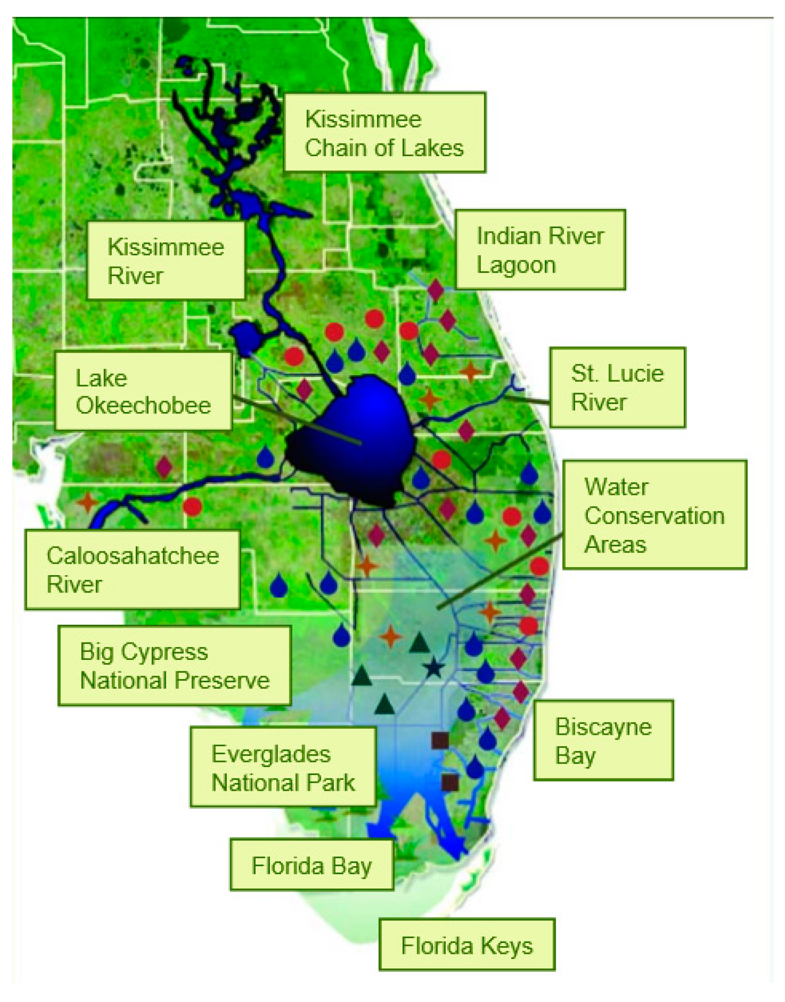
Figure 1. Map of southern Florida showing the locations of key geographic points and various projects within the Everglades Comprehensive Restoration Plan. The red dot above the Caloosahatchee River label is the Hendry County Reservoir.
Water 09 00774 g001
Figure 2. Map showing the location of Lehigh Acres in Lee County, Florida. The total area shown in red is about 249 km2.
Water 09 00774 g002
Figure 3. Hydrogeologic units at the LAB-TW test well site located at the Caloosahatchee River (C-43) West Basin Storage Reservoir (from Reese and Richardson [23]).
Water 09 00774 g003
Figure 4. Map showing the location of the C-43 reservoir, Lehigh Acres and the MAR wells are located along the western boundary of the reservoir south of SR-80. They run in a north-south orientation at the boundary between the Lee and Hendry counties (from the U.S. Army Corps of Engineers).
Water 09 00774 g004
Figure 5. Map showing the groundwater model area, Lehigh Acres and the MAR wells are located along the western boundary of the reservoir south of SR-80. They run in a north-south orientation at the boundary between the Lee and Hendry counties.
Water 09 00774 g005
Figure 6. Solute-transport modeling results showing the movement of the injected freshwater plume at 1 (a), 2 (b), 5 (c), and 10 (d) years with a gradient of 1.9 × 10⁻⁴.
Water 09 00774 g006
Table 1. Breakdown of Capital Costs for the Proposed MAR System.
ItemNo.Capacity (Each)Cost
MAR Wells1015,150 m3/d$10,000,000
Injection Pumps1015,150 m3/d$500,000
Filtration System1151,150 m3/d$15,000,000
Wellhead1015,150 m3/d$150,000
Electrical/Mechanical for Wells10n/a$2,000,000
Conveyance Piping to MAR Wells2500 m151,150 m3/d$1,000,000
Backflush Apparatus10n/a$550,000
SCADA System1n/a$200,000
Trickle wellhead chlorination10227.3 kg/day$300,000
Total $29,700,000
Table 2. Estimated Operating Costs of the MAR System (Injection Only) at the Kissimmee ASR Site [35].
ItemCost in $/MonthVolume Injected (m3/Month)Cost in $/m3
Labor26,033473,485$0.055
Electrical19,300473,485$0.041
Maintenance 13050473,485$0.006
Other Operational Maintenance 2515473,485$0.001
Additional general service costs 31350473,485$0.003
Total50,248473,485$0.106
Notes: 1 Includes recharge pump, UV disinfection system, recovery pump, electrical gear, SCADA, process piping & system disinfection. 2 Includes well rehabilitation, sludge removal & disposal, HVAC, materials, small tools & supplies, and data services. 3 Includes additional monitoring and administrative costs.