
Evaluation of Soil Water Availability (SWA) Based on Hydrological Modelling in Arid and Semi-Arid Areas: A Case Study in Handan City, China


Abstract
:1. Introduction
2. Materials and Methods
2.1. Soil Water Simulation Tool
2.2. Soil Water Availability Evaluation Method
2.2.1. Definition of Soil Water Availability
2.2.2. Framework of the Soil Water Availability Index System
Index for Soil Water Storage Capacity (C1)
Index for the Operational Characteristics of the Farmland Soil Reservoir (C2)
Index of Degree of Matching between the Soil Water Supply and Crop Water Demand (C3)
Index for Soil Water Transformation and Crop Absorption Efficiency (C4)
2.2.3. Analytic Hierarchy Process
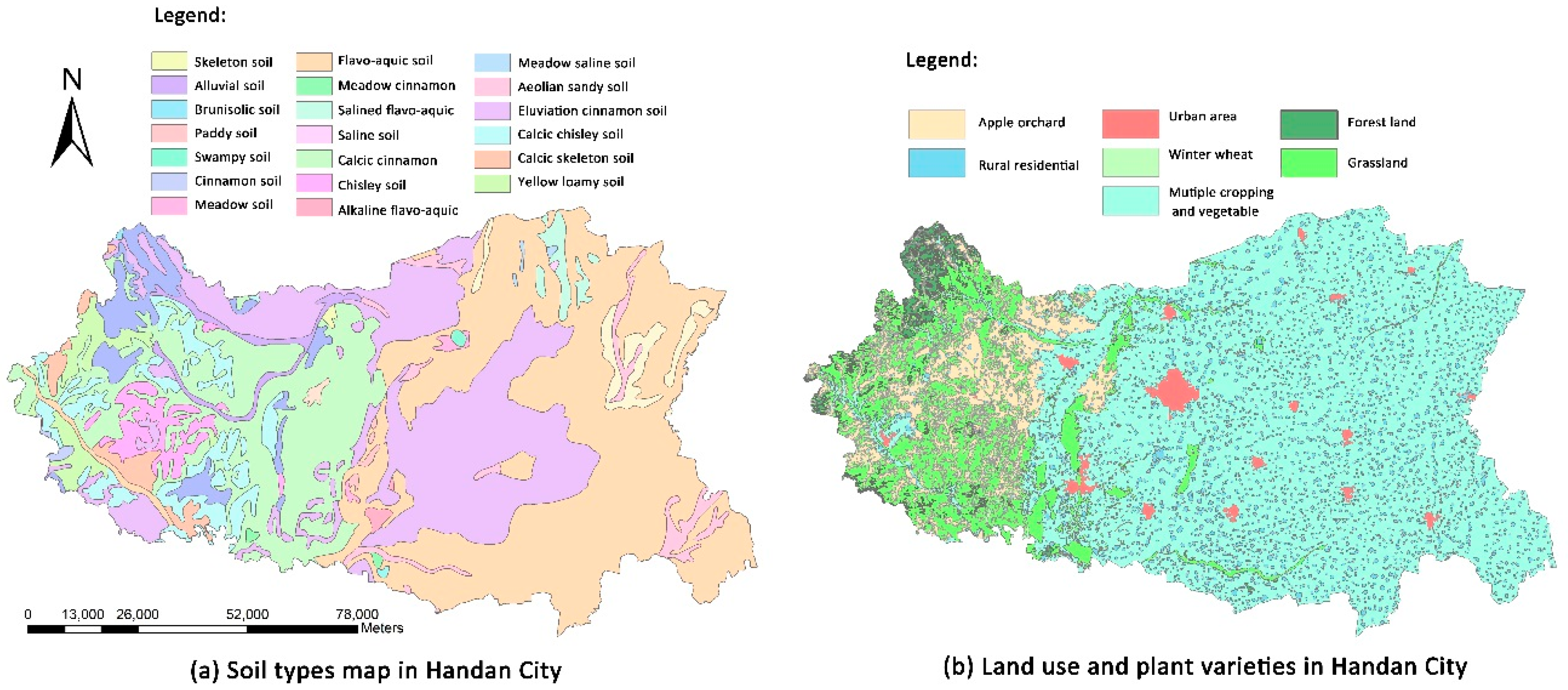
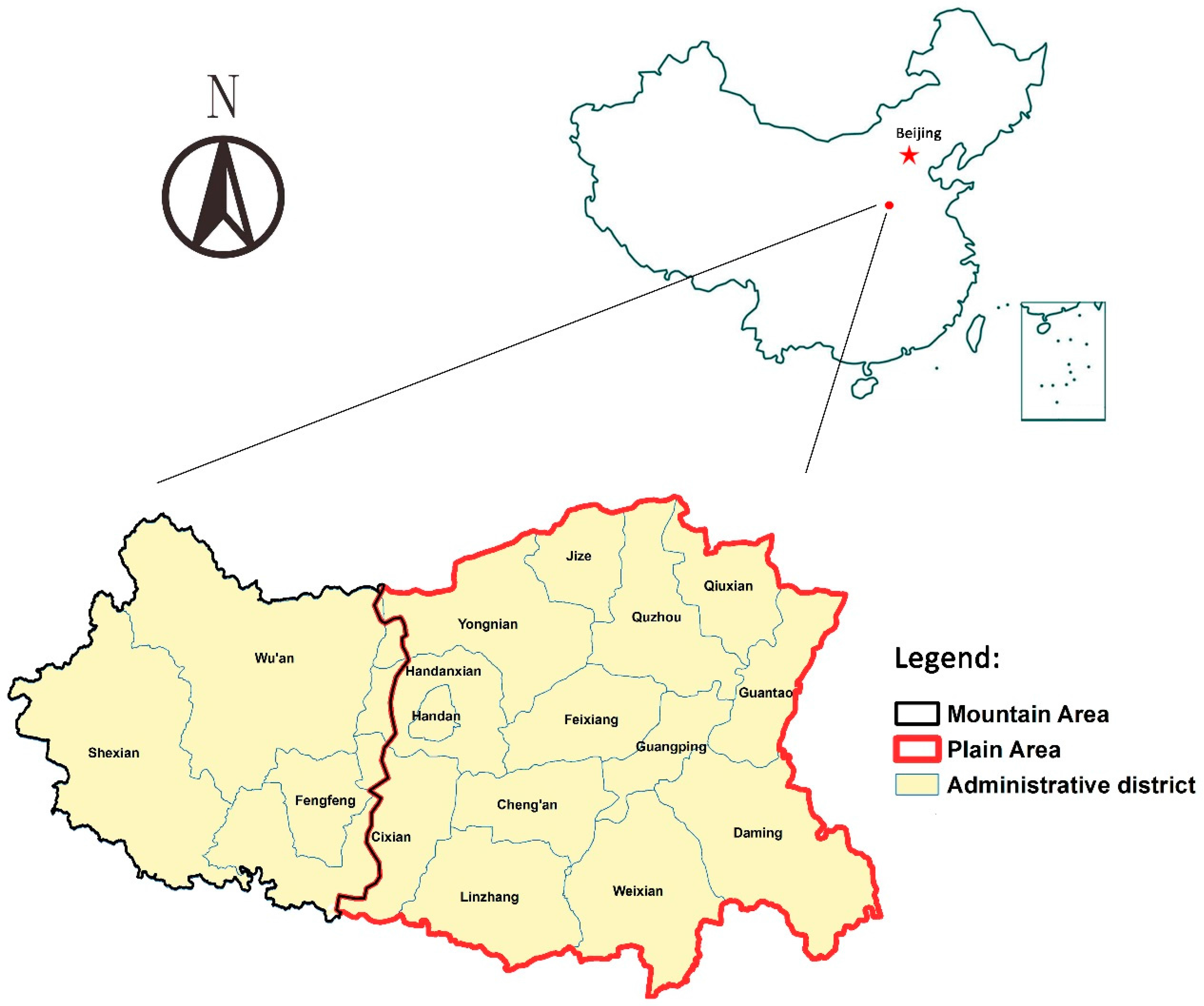
2.3. Overview of the Study Area
3. Results
3.1. Model Construction
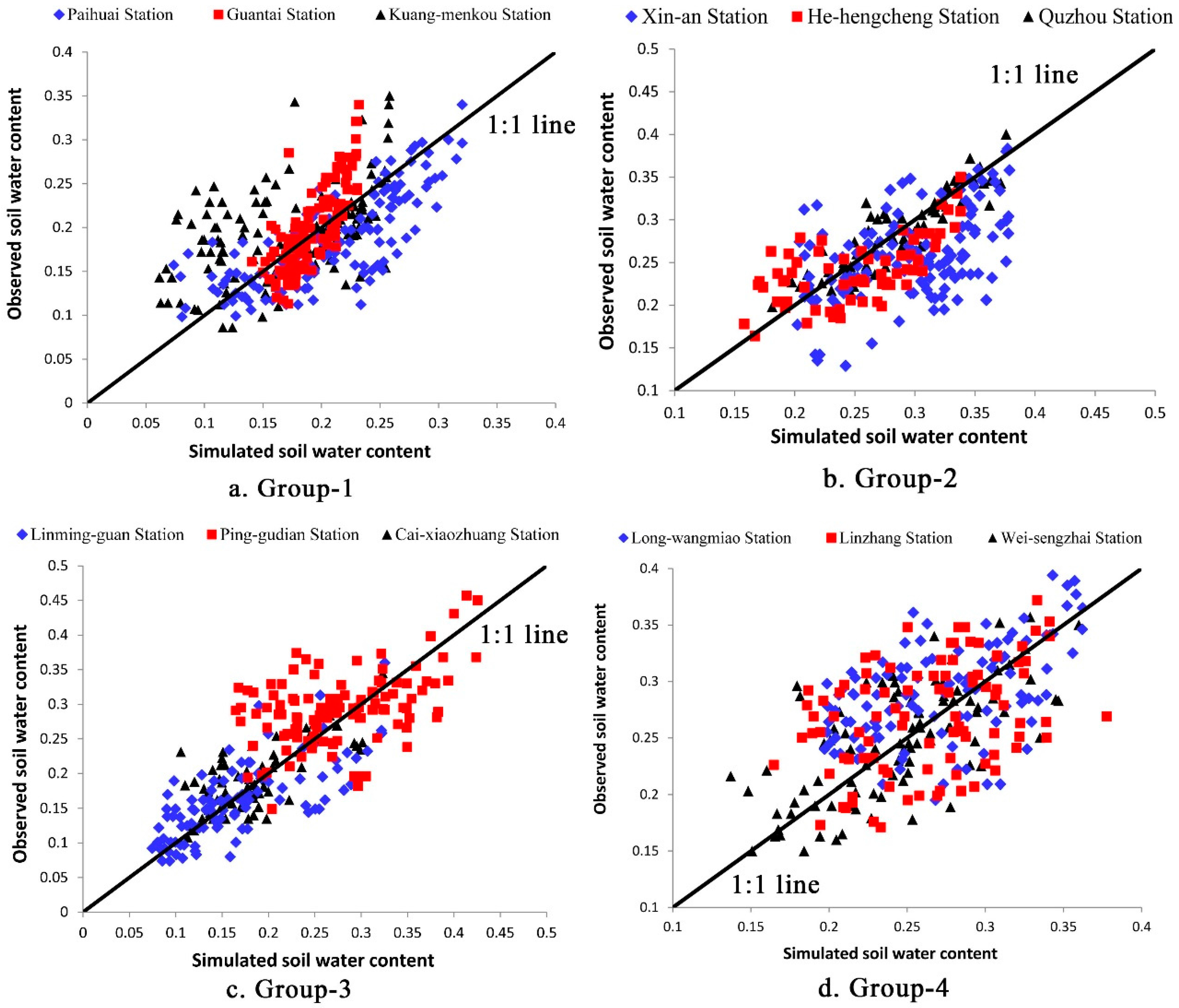
3.2. Model Validation
3.3. Soil Water Availability Quantitatively Evaluation
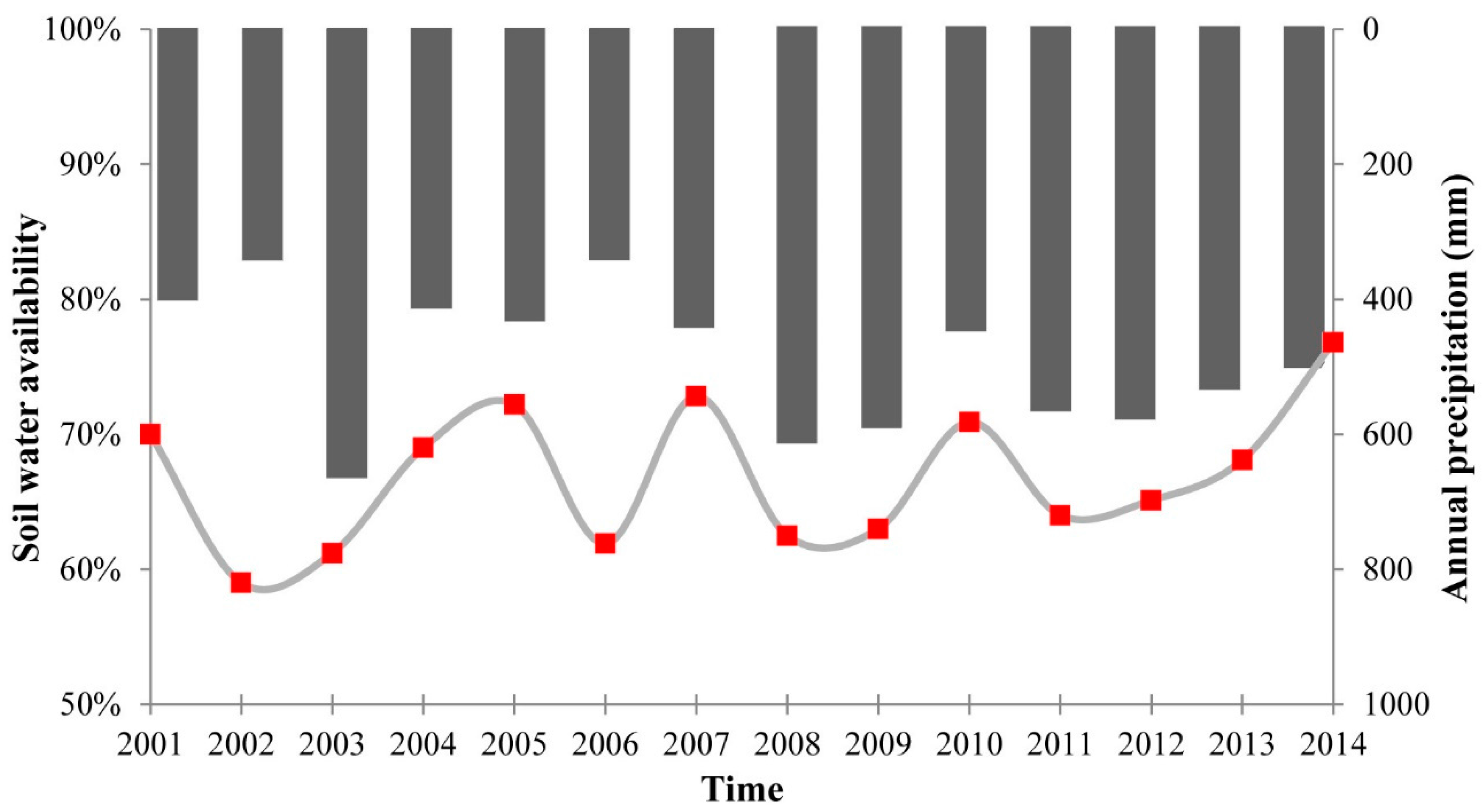
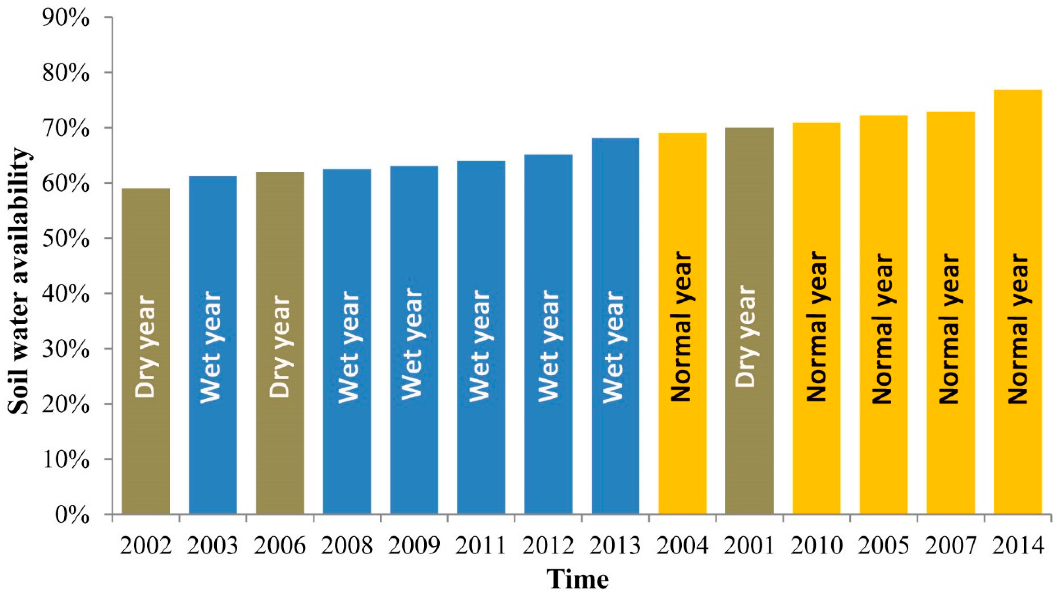
3.3.1. Temporal Perspective
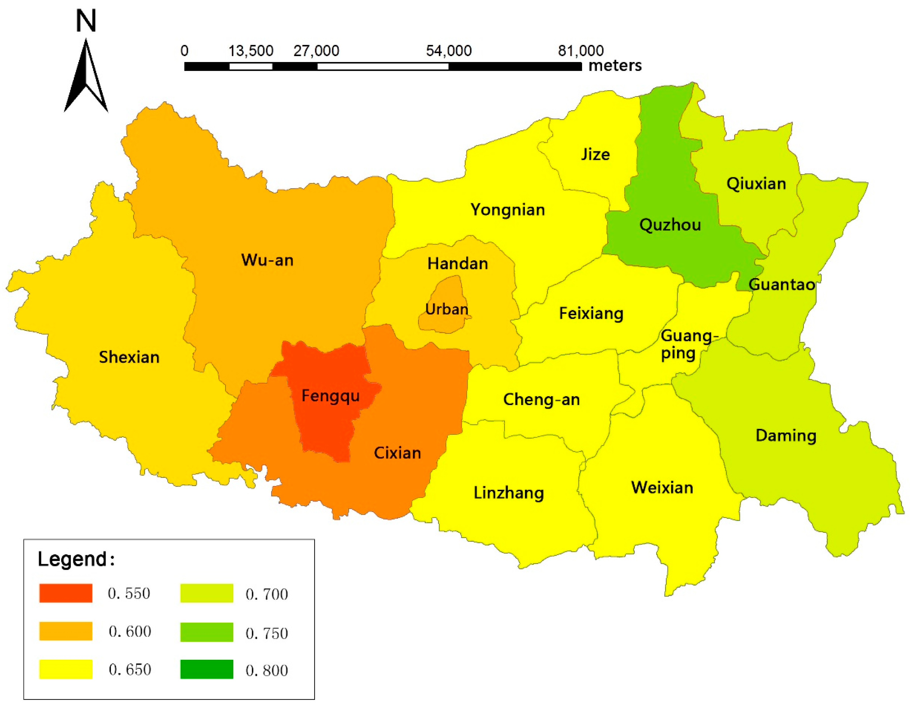
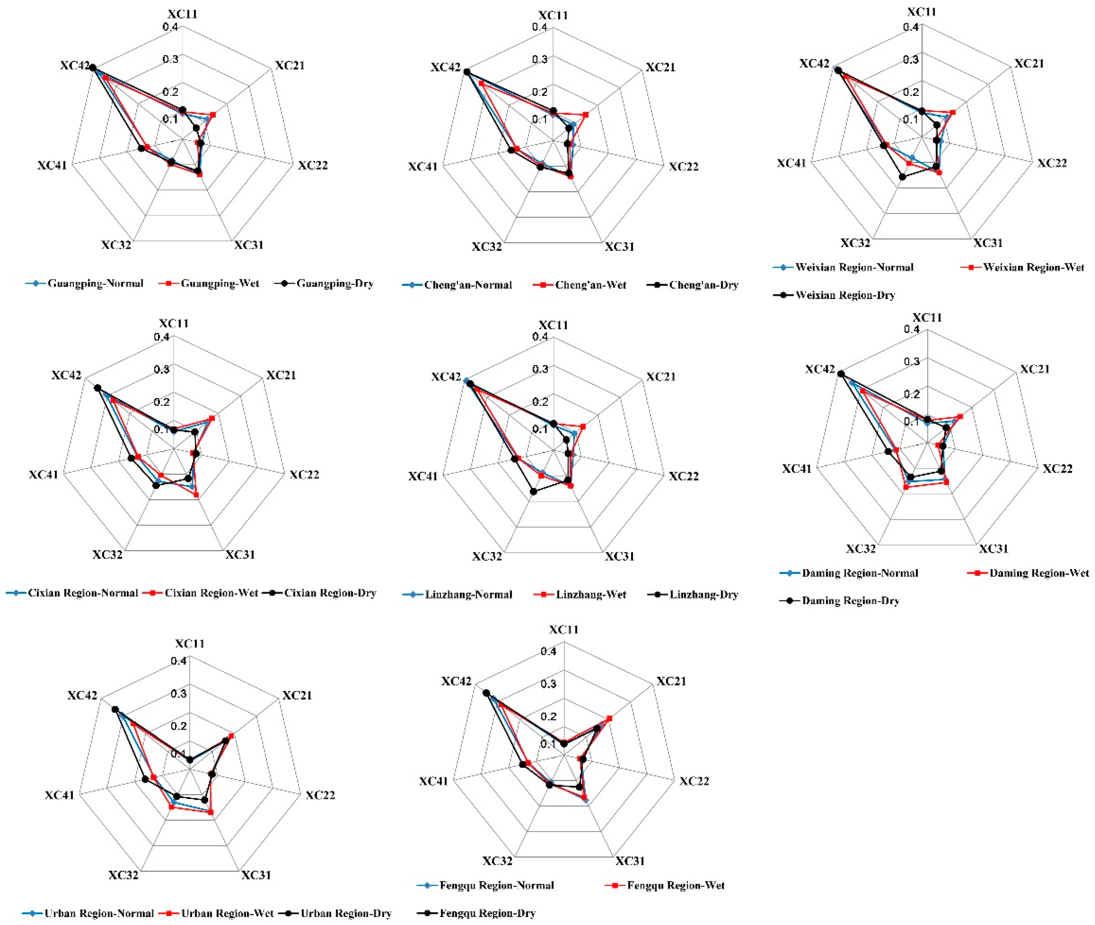
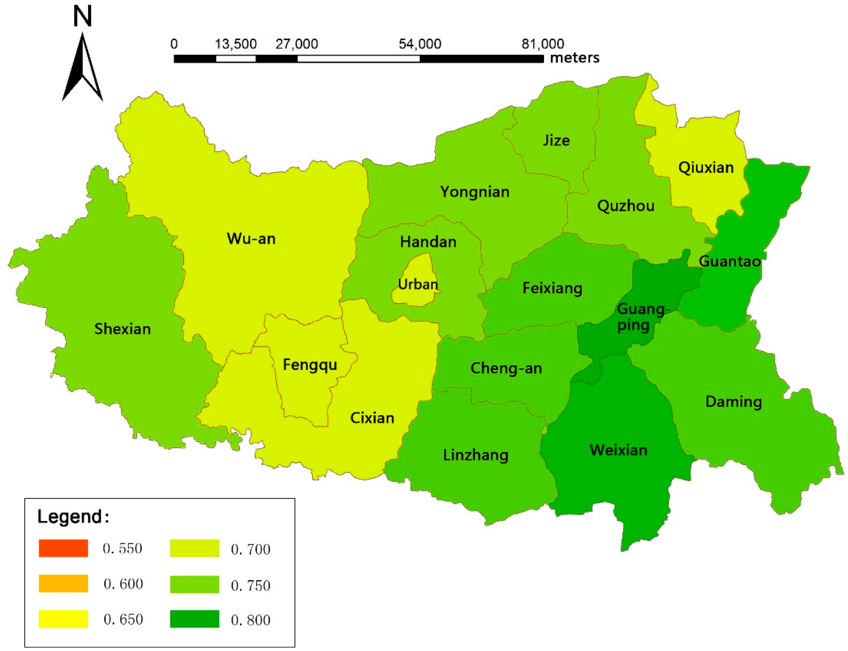
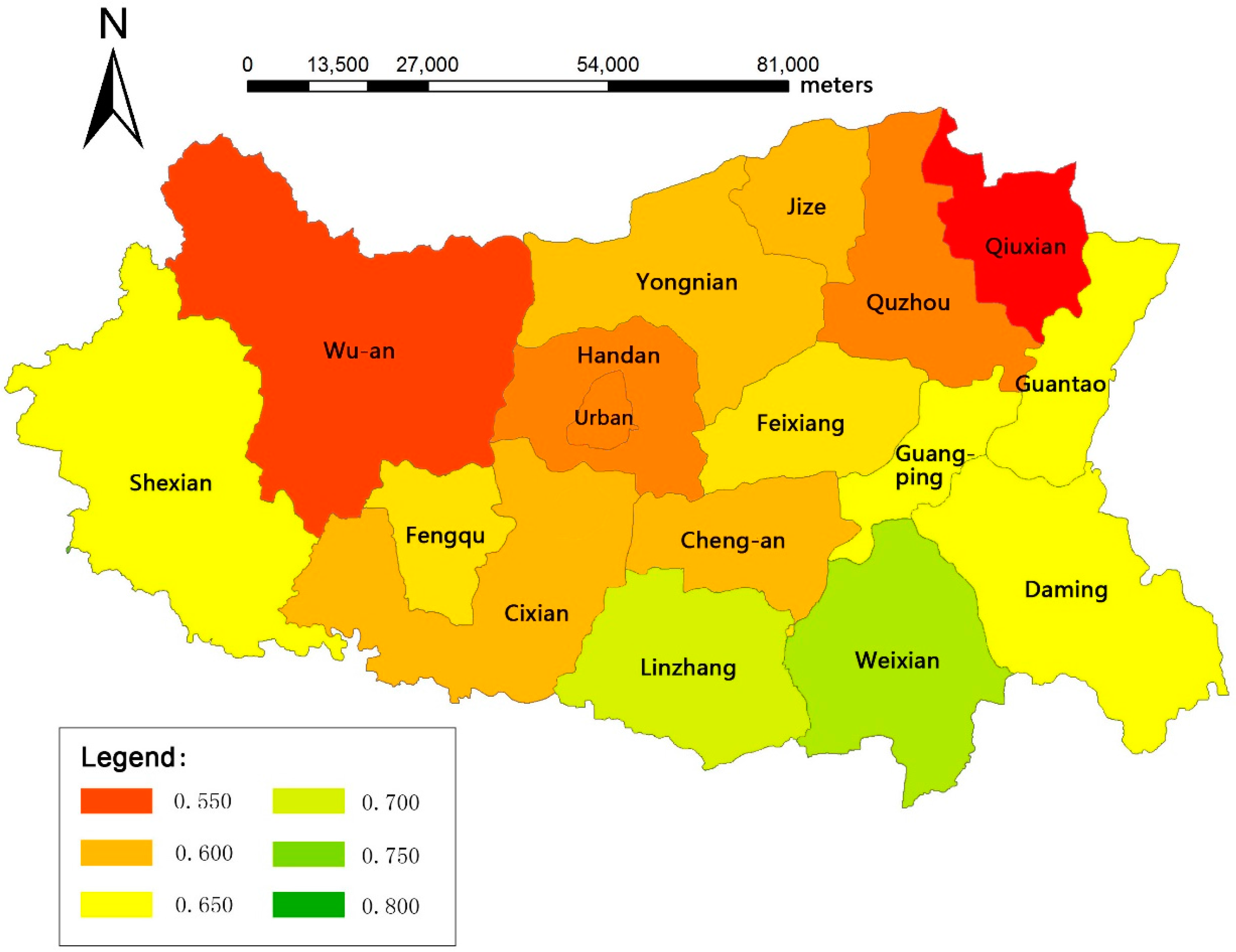
3.3.2. Spatial Perspective
4. Discussion
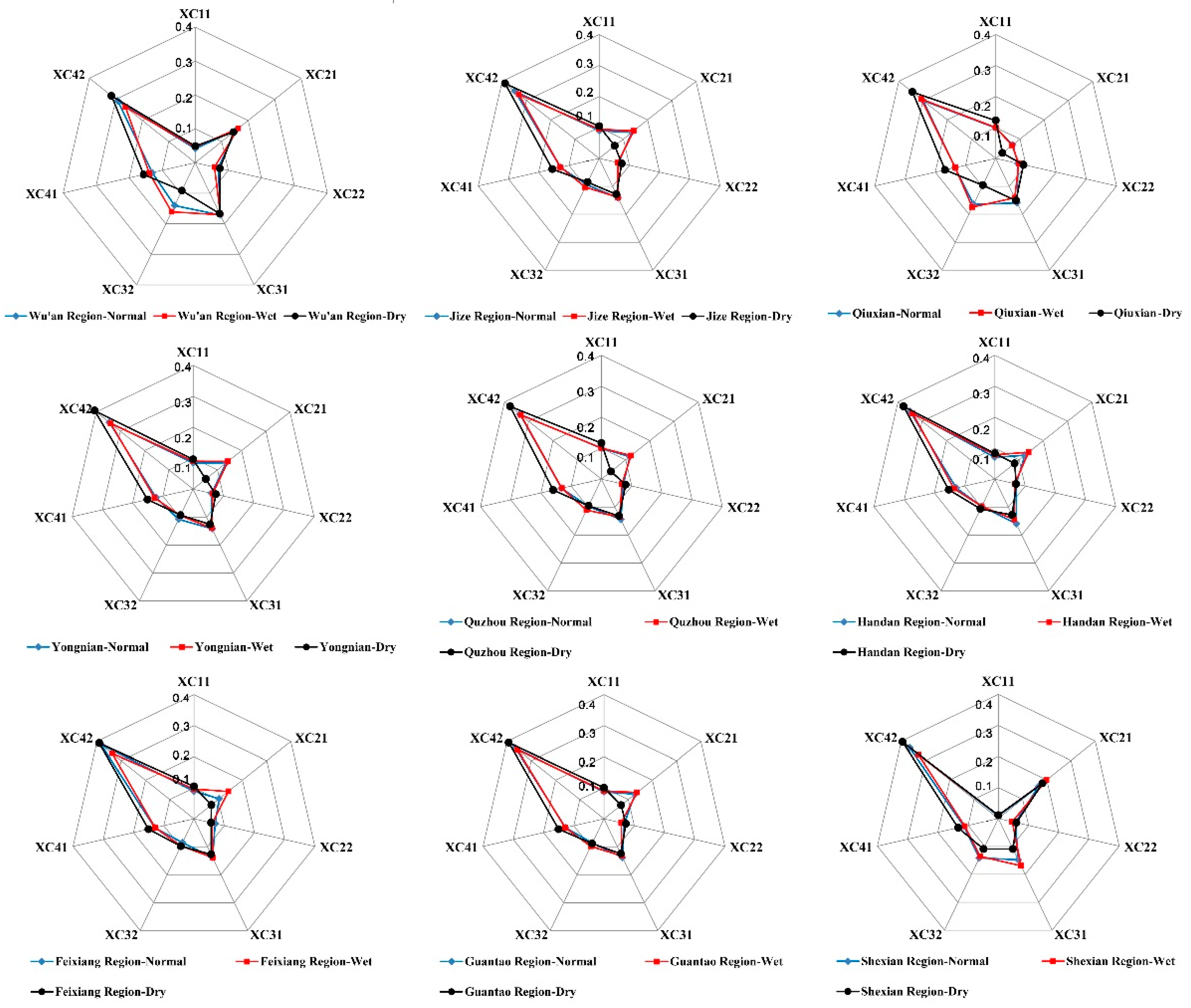
4.1. Analysis of the Main Factors Influencing the Soil Water Availability for Different Regions
4.2. Strategies to Improve Soil Water Availability
5. Conclusions
Acknowledgments
Author Contributions
Conflicts of Interest
References
- Xu, X.; Yang, D.; Yang, H.; Lei, H. Attribution analysis based on the Budyko hypothesis for detecting the dominant cause of runoff decline in Haihe basin. J. Hydrol. 2014, 510, 530–540. [Google Scholar] [CrossRef]
- Lema, M.A.; Majule, A.E. Impacts of climate change, variability and adaptation countermeasures on agriculture in semiarid areas of Tanzania: The case of Manyoni District in Singida Region, Tanzania. Afr. J. Environ. Sci. Technol. 2009, 3, 206–218. [Google Scholar]
- Robinson, D.A.; Campbell, C.S.; Hopmans, J.W.; Hornbuckle, B.K.; Jones, S.B.; Knight, R.; Ogden, F.; Selker, J.; Wendroth, O. Soil moisture measurements for ecological and hydrological watershed scale observatories: A review. Vadose Zone J. 2008, 7, 358–389. [Google Scholar] [CrossRef]
- Walker, J.P.; Houser, P.R.; Willgoose, G.R. Active microwave remote sensing for soil moisture measurement: A field evaluation using ERS-2. Hydrol. Process. 2004, 18, 1975–1997. [Google Scholar] [CrossRef]
- Deans, J.D.; Milne, R. An electrical recording soil moisture tensiometer. Plant Soil 1978, 50, 509–513. [Google Scholar] [CrossRef]
- Kodikara, J.; Rajeev, P.; Chan, D.; Gallage, C. Soil moisture monitoring at the field scale using neutron probe. Can. Geotech. J. 2014, 51, 332–345. [Google Scholar] [CrossRef] [Green Version]
- Dasberg, S.; Dalton, F.N. Time domain reflectometry field measurements of soil water content and electrical conductivity. Soil Sci. Soc. Am. J. 1985, 49, 293–297. [Google Scholar] [CrossRef]
- Dirksen, C.; Dasberg, S. Improved calibration of time domain reflectometry soil water content measurements. Soil Sci. Soc. Am. J. 1993, 57, 660–667. [Google Scholar] [CrossRef]
- Tanaka, D.L.; Aase, J.K. Fallow method influences on soil water and precipitation storage efficiency. Soil Till. Res. 1987, 9, 307–316. [Google Scholar] [CrossRef]
- Zegelin, S.J.; White, I.; Jenkins, D.R. Improved field probes for soil water content and electrical conductivity measurement using time domain reflectometry. Water Resour. Res. 1989, 25, 2367–2376. [Google Scholar] [CrossRef]
- Gao, X.; Wu, P.; Zhao, X.; Wang, J.; Shi, Y.; Zhang, B.; Tian, L.; Li, H. Estimation of spatial soil moisture averages in a large gully of the Loess Plateau of China through statistical and modeling solutions. J. Hydrol. 2013, 486, 466–478. [Google Scholar] [CrossRef]
- Wagner, W.; Lemoine, G.; Rott, H. A Method for Estimating Soil Moisture from ERS Scatterometer and Soil Data. Remote Sens. Environ. 1999, 70, 191–207. [Google Scholar] [CrossRef]
- Schmugge, T.J.; Kustas, W.P.; Ritchie, J.C.; Jackson, T.J.; Rango, A. Remote sensing in hydrology. Adv. Water Resour. 2002, 25, 1367–1385. [Google Scholar] [CrossRef]
- Vereecken, H.; Huisman, J.A.; Bogena, H.; Vanderborght, J.; Vrugt, J.A.; Hopmans, J.W. On the value of soil moisture measurements in vadose zone hydrology: A review. Water Resour. Res. 2008, 44, W00D06. [Google Scholar] [CrossRef]
- Ulaby, F.T.; Dubois, P.C.; Van Zyl, J. Radar mapping of surface soil moisture. J. Hydrol. 1996, 184, 57–84. [Google Scholar] [CrossRef]
- Fernández-Prieto, D.; van Oevelen, P.; Su, Z. Advances in Earth observation for water cycle science. Hydrol. Earth Syst. Sci. 2012, 16, 543–549. [Google Scholar] [CrossRef]
- Kong, X.; Dorling, S.R. Near-surface soil moisture retrieval from ASAR Wide Swath imagery using a Principal Component Analysis. Int. J. Remote Sens. 2008, 29, 2925–2942. [Google Scholar] [CrossRef]
- Ford, T.W.; Harris, E.; Quiring, S.M. Estimating root zone soil moisture using near-surface observations from SMOS. Hydrol. Earth Syst. Sci. 2014, 18, 139–154. [Google Scholar] [CrossRef]
- Martínez-Fernández, J.; González-Zamora, A.; Sánchez, N.; Gumuzzio, A.; Herrero-Jiménez, C.M. Satellite soil moisture for agricultural drought monitoring: Assessment of the SMOS derived Soil Water Deficit Index. Remote Sens. Environ. 2016, 177, 277–286. [Google Scholar] [CrossRef]
- Ni-Meister, W. Recent advances on soil moisture data assimilation. Phys. Geogr. 2008, 29, 19–37. [Google Scholar] [CrossRef]
- Montaldo, N.; Albertson, J.D. Multi-scale assimilation of surface soil moisture data for robust root zone moisture predictions. Adv. Water Resour. 2003, 26, 33–44. [Google Scholar] [CrossRef]
- Reichle, R.H.; Koster, R.D. Global assimilation of satellite surface soil moisture retrievals into the NASA Catchment land surface model. Geophys. Res. Lett. 2005, 32, 177–202. [Google Scholar]
- Kim, S. Time series modeling of soil moisture dynamics on a steep mountainous hillside. J. Hydrol. 2016, 536, 37–49. [Google Scholar] [CrossRef]
- Gao, X.; Lu, C.; Luan, Q.; Zhang, S.; Liu, J.; Han, D. Mapping farmland-soil moisture at a regional scale using a distributed hydrological model: Case study in the north china plain. J. Irrig. Drain. Eng. 2016, 142, 04016029. [Google Scholar] [CrossRef]
- Fu, B.; Yang, Z.; Wang, Y.; Zhang, P. A mathematical model of soil moisture spatial distribution on the hill slopes of the Loess Plateau. Sci. China Earth Sci. 2001, 44, 395–402. [Google Scholar] [CrossRef]
- Zhang, J.E.; Lu, C.Y.; Qin, D.Y.; Guo, Y.X.; Ge, H.F. Regional runoff study based on MODCYCLE distributed hydrology model. Trans. Chin. Soc. Agric. Eng. 2011, 27, 65–71. [Google Scholar]
- Arnold, J.G.; Allen, P.M.; Bernhardt, G. A comprehensive surface-ground water flow model. J. Hydrol. 1993, 142, 47–69. [Google Scholar] [CrossRef]
- Mapfumo, E.; Chanasyk, D.S.; Willms, W.D. Simulating daily soil water under foothills fescue grazing with the soil and water assessment tool model (Alberta, Canada). Hydrol. Process. 2004, 18, 2787–2800. [Google Scholar] [CrossRef]
- Li, M.X.; Ma, Z.G.; Du, J.W. Regional soil moisture simulation for Shaanxi Province using SWAT model validation and trend analysis. Sci. China Earth Sci. 2010, 53, 575–590. [Google Scholar] [CrossRef]
- Zhang, J.E.; Lu, C.Y.; Qin, D.Y.; Wang, R.D. MODCYCLE—An object oriented modularized hydrological model II. Application. Shuilixuebao. J. Hydraul. Eng. 2012, 43, 1287–1295. [Google Scholar]
- Liu, J.; Wei, C.; Xie, Q.; Zhang, W. Capacities of soil water reservoirs and their better regression models by combining “merged groups PCA” in Chongqing, China. Acta Ecol. Sin. 2014, 34, 53–65. [Google Scholar] [CrossRef]
- Gu, S.X.; Xiong, Y.L.; Xu, X.; Wei, C.F.; Liu, G.C. Research progress on soil reservoir and utilization rainfall resources. Southwest China J. Agric. Sci. 2003, 16, 29–32. [Google Scholar]
- Zhang, J.; Lu, C.; Qin, D.; Liu., M. Regional “four-water” transformation based on distributed hydrological model. Adv. Water Sci. 2011, 22, 595–604. [Google Scholar]
- Stanhill, G. Water use efficiency. Adv. Agron. 1986, 39, 53–85. [Google Scholar]
- Saaty, T.L. A scaling method for priorities in hierarchical structures. J. Math. Psychol. 1977, 15, 234–281. [Google Scholar] [CrossRef]
- Vaidya, O.S.; Kumar, S. Analytic hierarchy process: An overview of applications. Eur. J. Oper. Res. 2006, 169, 1–29. [Google Scholar] [CrossRef]
- Saaty, T.L. The modern science of multicriteria decision making and its practical applications: The AHP/ANP approach. Oper. Res. 2013, 61, 1101–1118. [Google Scholar] [CrossRef]
- Sara, J.; Stikkelman, R.M.; Herder, P.M. Assessing relative importance and mutual influence of barriers for CCS deployment of the ROAD project using AHP and DEMATEL methods. Int. J. Greenh. Gas Control 2015, 41, 336–357. [Google Scholar] [CrossRef]
- Wind, Y.; Saaty, T.L. Marketing applications of the analytic hierarchy process. Manag. Sci. 1980, 26, 641–658. [Google Scholar] [CrossRef]
- Saaty, T.L. Decision making-the analytic hierarchy and network processes (AHP/ANP). J. Syst. Sci. Syst. Eng. 2004, 13, 1–35. [Google Scholar] [CrossRef]
- The Ministry of Economy, Trade, and Industry (METI) of Japan; The United States National Aeronautics and Space Administration (NASA). ASTER Global Digital Elevation Model (GDEM). Available online: http://www.jspacesystems.or.jp/ersdac/GDEM/E/4.html (accessed on 12 October 2015).
- National Meteorological Information Centre of China. China Meteorological Data Network. Available online: http://data.cma.cn/data/detail/dataCode/A.0012.0001.html (accessed on 18 February 2016).


| Factor | First-Class Index | Second-Class Index | Description |
|---|---|---|---|
| Availability of soil water quantity | The soil water storage capacity (C1) | The valid capacity of soil reservoir (C11) | The valid water supply capacity (equivalent water depth) of the soil in the crop root zone, mm. |
| Operational characteristics of farmland soil reservoir (C2) | Average value of annual empty storage capacity of the soil reservoir (C21) | To characterise the average soil water shortage severity in the soil root zone within a year, mm. | |
| Average annual variation of empty storage capacity of the soil reservoir (C22) | To characterise the fluctuation of water shortage severity in the root zone within a year, dimensionless. | ||
| The spatial and temporal matching of soil water resource between supply and demand | Temporal and spatial matching degree (C3) | Temporal matching degree index (C31) | The temporal matching degree between soil water supply and crop water requirement, dimensionless. |
| Spatial matching degree index (C32) | The spatial matching degree between soil water supply and crop water requirement, dimensionless. | ||
| The efficiency of soil water transformation and plant uptake | Soil water transformation and crop absorption efficiency (C4) | Soil water conversion efficiency (C41) | To characterise the efficiency of water transforming from other types to soil water, dimensionless. |
| Crop absorption efficiency (C42) | To characterise the efficiency the soil water is absorbed by crops and plants, dimensionless. |
| Factors | ||||
|---|---|---|---|---|
| 1 | 0.25 | 0.5 | 0.125 | |
| 4 | 1 | 0.5 | 0.333 | |
| 2 | 2 | 1 | 0.5 | |
| 8 | 3 | 2 | 1 |
| Data Types | Detail | Source |
|---|---|---|
| Basic geographic information | 1. DEM (90 m × 90 m) | Land Processes Distributed Active Archive Center of USA [41]. |
| 2. Land use map (1:100,000) | The map was retrieved by remote sensing data, which are provided by Data Center for Resources and Environmental Sciences, Chinese Academy of Sciences (RESDC): http://www.resdc.cn | |
| 3. Soil property map (1:100,000) | China Soil Scientific Database: http://www.soil.csdb.cn/ | |
| 4. Digital river and reservoir (1:250,000) | The digital river and reservoir map was drawn based on the paper map using GIS tool | |
| 5. Groundwater aquifer data | The data were collected from Handan Water Conservancy Bureau | |
| Meteorological observed data | 1. Daily rainfall | China Meteorological Data Network [42]. |
| 2. Average daily temperature | ||
| 3. Average daily wind speed | ||
| 4. Daily sun radiation | ||
| 5. Average relative humidity | ||
| Agricultural management regimes | 1. Crop varieties | The data were collected from “Rural Statistical Yearbook of Hebei Province” |
| 2. Planting configuration | ||
| 3. Irrigation regimes | ||
| Hydrological data | 1. Runoff in 5 main rivers | The data were collected from Handan Water Conservancy Bureau |
| 2. Inflow and outflow in 12 reservoirs | ||
| 3. Soil moisture data measured in 12 monitoring stations | ||
| Others | 1. socio-economic water consumption data. | The data were derived from “Statistical Yearbook of Handan” |
| NO. | Parameter | Description | Optimal Value |
|---|---|---|---|
| 1 | MXSP | Maximum water depth stored in the surface of farmland, which is closely related to runoff generation | 100 mm |
| 2 | ESCO | Correction coefficient in calculating soil evaporation from the soil profile, which is an important factor affecting water volume evaporated in different soil layers | 0.70 |
| 3 | EPCO | Correction coefficient in calculating the plant evapotranspiration from the soil profile, which affects water volume absorbed by plant in different soil layers | 0.96 |
| 4 | FFCB | The ratio between initial soil moisture and field capacity of the soil profile | 0.6 |
| 5 | GWEC | Coefficient in calculating the water volume recharged from groundwater aquifer to soil profile | 0.89 |
| 6 | SLAG | Runoff lag coefficient | 3.2 |
| 7 | SOLK | The hydraulic conductivity of different soil layers | 2–150 mm/h |
| 8 | SOLA | Depth of available water in the soil profile | 100–600 mm |
| 9 | CANM | Maximum water depth intercepted by crop canopy | 6 mm |
| 10 | BIOE | The radiation-use efficiency of the plant | 15–40 (kg/ha)/(MJ/m2) |
| Group | ID | Station Name | County | Water Source | Latitude | Longitude |
|---|---|---|---|---|---|---|
| Group-1 | 1 | Paihuai Station | Wu’an | Rain-fed | 114.02 | 36.62 |
| 2 | Guantai Station | Cixian | Rain-fed | 114.08 | 36.33 | |
| 3 | Kuang-menkou Station | Shexian | Rain-fed | 113.78 | 36.45 | |
| Group-2 | 4 | Xin-an Station | Feixiang | Rain-fed | 114.68 | 36.55 |
| 5 | He-hengcheng Station | Cheng’an | Rain-fed | 114.57 | 36.48 | |
| 6 | Quzhou Station | Quzhou | Rain-fed | 114.97 | 36.78 | |
| Group-3 | 7 | Linming-guan Station | Yongnian | Rain-fed | 114.48 | 36.67 |
| 8 | Ping-gudian Station | Guangping | Rain-fed | 115.07 | 36.57 | |
| 9 | Cai-xiaozhuang Station | Weixian | Irrigation | 114.93 | 36.28 | |
| Group-4 | 10 | Long-wangmiao Station | Daming | Irrigation | 115.22 | 36.22 |
| 11 | Linzhang Station | Linzhang | Irrigation | 114.62 | 36.35 | |
| 12 | Wei-sengzhai Station | Guantao | Irrigation | 115.38 | 36.72 |
| ID | Station Name | Observed Average Value | Simulated Average Value | ER (%) | R |
|---|---|---|---|---|---|
| 1 | Paihuai Station | 0.173 | 0.189 | 8.83 | 0.87 |
| 2 | Guantai Station | 0.201 | 0.187 | 6.94 | 0.82 |
| 3 | Kuang-menkou Station | 0.155 | 0.152 | 1.79 | 0.95 |
| 4 | Xin-an Station | 0.275 | 0.301 | 9.33 | 0.76 |
| 5 | He-hengcheng Station | 0.241 | 0.253 | 4.75 | 0.72 |
| 6 | Quzhou Station | 0.241 | 0.253 | 4.75 | 0.75 |
| 7 | Linming-guan Station | 0.248 | 0.243 | 2.02 | 0.95 |
| 8 | Ping-gudian Station | 0.261 | 0.264 | 1.15 | 0.97 |
| 9 | Cai-xiaozhuang Station | 0.195 | 0.187 | 3.93 | 0.72 |
| 10 | Long-wangmiao Station | 0.313 | 0.289 | 7.45 | 0.6 |
| 11 | Linzhang Station | 0.257 | 0.26 | 1.47 | 0.52 |
| 12 | Wei-sengzhai Station | 0.248 | 0.255 | 2.82 | 0.77 |
| Normal Year (2010) | XC11 | XC21 | XC22 | XC31 | XC32 | XC41 | XC42 | U |
|---|---|---|---|---|---|---|---|---|
| Wu’an Region | 0.416 | 0.836 | 0.806 | 1.00 | 0.82 | 0.915 | 0.513 | 0.701 |
| Jize Region | 0.899 | 0.730 | 0.754 | 0.83 | 0.55 | 0.900 | 0.611 | 0.703 |
| Qiuxian Region | 0.983 | 0.377 | 0.864 | 0.93 | 0.96 | 0.943 | 0.525 | 0.701 |
| Yongnian Region | 0.848 | 0.736 | 0.710 | 0.83 | 0.63 | 0.859 | 0.606 | 0.701 |
| Quzhou Region | 0.981 | 0.617 | 0.836 | 0.83 | 0.56 | 0.910 | 0.579 | 0.688 |
| Handan Region | 0.723 | 0.680 | 0.839 | 0.95 | 0.58 | 0.913 | 0.625 | 0.714 |
| Feixiang Region | 0.914 | 0.572 | 0.840 | 0.83 | 0.51 | 0.931 | 0.689 | 0.718 |
| Guantao Region | 0.895 | 0.709 | 0.806 | 0.83 | 0.52 | 0.917 | 0.659 | 0.720 |
| Shexian Region | 0.100 | 0.976 | 0.723 | 0.94 | 0.90 | 0.872 | 0.698 | 0.764 |
| Guangping Region | 0.921 | 0.629 | 0.840 | 0.83 | 0.51 | 0.922 | 0.686 | 0.724 |
| Cheng’an Region | 0.919 | 0.493 | 0.844 | 0.83 | 0.53 | 0.933 | 0.685 | 0.710 |
| Weixian Region | 0.879 | 0.629 | 0.813 | 0.83 | 0.49 | 0.932 | 0.691 | 0.720 |
| Cixian Region | 0.573 | 0.785 | 0.800 | 0.83 | 0.71 | 0.877 | 0.511 | 0.667 |
| Linzhang Region | 0.893 | 0.517 | 0.842 | 0.83 | 0.53 | 0.922 | 0.704 | 0.717 |
| Daming Region | 0.771 | 0.741 | 0.734 | 0.94 | 1.00 | 0.921 | 0.668 | 0.786 |
| Urban Region | 0.281 | 0.889 | 0.871 | 0.95 | 0.75 | 0.891 | 0.529 | 0.692 |
| Fengqu Region | 0.355 | 0.896 | 0.702 | 1.00 | 0.61 | 0.869 | 0.541 | 0.680 |
| Average in the whole area | 0.727 | 0.672 | 0.798 | 0.87 | 0.66 | 0.910 | 0.623 | 0.712 |
| Wet Year (2012) | XC11 | XC21 | XC22 | XC31 | XC32 | XC41 | XC42 | U |
|---|---|---|---|---|---|---|---|---|
| Wu’an Region | 0.416 | 0.784 | 0.608 | 0.89 | 0.84 | 0.873 | 0.414 | 0.628 |
| Jize Region | 0.899 | 0.728 | 0.684 | 0.77 | 0.57 | 0.849 | 0.551 | 0.665 |
| Qiuxian Region | 0.983 | 0.358 | 0.874 | 0.81 | 1.00 | 0.921 | 0.529 | 0.689 |
| Yongnian Region | 0.848 | 0.729 | 0.711 | 0.77 | 0.52 | 0.839 | 0.560 | 0.659 |
| Quzhou Region | 0.981 | 0.641 | 0.774 | 0.77 | 0.63 | 0.894 | 0.568 | 0.683 |
| Handan Region | 0.723 | 0.686 | 0.703 | 0.77 | 0.52 | 0.865 | 0.542 | 0.640 |
| Feixiang Region | 0.914 | 0.727 | 0.671 | 0.77 | 0.54 | 0.857 | 0.562 | 0.666 |
| Guantao Region | 0.895 | 0.728 | 0.663 | 0.77 | 0.57 | 0.892 | 0.618 | 0.694 |
| Shexian Region | 0.100 | 0.975 | 0.491 | 0.9 | 0.72 | 0.708 | 0.526 | 0.639 |
| Guangping Region | 0.921 | 0.704 | 0.601 | 0.77 | 0.55 | 0.856 | 0.581 | 0.668 |
| Cheng’an Region | 0.919 | 0.737 | 0.652 | 0.77 | 0.54 | 0.866 | 0.531 | 0.655 |
| Weixian Region | 0.879 | 0.704 | 0.543 | 0.77 | 0.57 | 0.842 | 0.566 | 0.657 |
| Cixian Region | 0.573 | 0.757 | 0.66 | 0.87 | 0.5 | 0.741 | 0.394 | 0.574 |
| Linzhang Region | 0.893 | 0.682 | 0.673 | 0.77 | 0.55 | 0.845 | 0.572 | 0.663 |
| Daming Region | 0.771 | 0.778 | 0.435 | 0.89 | 1.00 | 0.770 | 0.501 | 0.685 |
| Urban Region | 0.281 | 0.882 | 0.765 | 0.87 | 0.76 | 0.807 | 0.392 | 0.613 |
| Fengqu Region | 0.355 | 0.881 | 0.534 | 0.77 | 0.53 | 0.724 | 0.396 | 0.558 |
| Average in the whole area | 0.727 | 0.716 | 0.64 | 0.81 | 0.65 | 0.838 | 0.525 | 0.649 |
| Dry Year (2006) | XC11 | XC21 | XC22 | XC31 | XC32 | XC41 | XC42 | U |
|---|---|---|---|---|---|---|---|---|
| Wu’an Region | 0.416 | 0.659 | 0.737 | 0.82 | 0.45 | 0.924 | 0.468 | 0.591 |
| Jize Region | 0.899 | 0.302 | 0.755 | 0.65 | 0.43 | 0.940 | 0.588 | 0.606 |
| Qiuxian Region | 0.983 | 0.121 | 0.861 | 0.71 | 0.45 | 0.945 | 0.484 | 0.564 |
| Yongnian Region | 0.848 | 0.248 | 0.776 | 0.65 | 0.48 | 0.933 | 0.629 | 0.619 |
| Quzhou Region | 0.981 | 0.178 | 0.791 | 0.65 | 0.47 | 0.942 | 0.556 | 0.590 |
| Handan Region | 0.723 | 0.381 | 0.718 | 0.65 | 0.54 | 0.929 | 0.573 | 0.608 |
| Feixiang Region | 0.914 | 0.339 | 0.581 | 0.65 | 0.50 | 0.922 | 0.599 | 0.613 |
| Guantao Region | 0.895 | 0.338 | 0.752 | 0.65 | 0.46 | 0.937 | 0.613 | 0.624 |
| Shexian Region | 0.100 | 0.923 | 0.658 | 0.6 | 0.60 | 0.875 | 0.650 | 0.658 |
| Guangping Region | 0.921 | 0.298 | 0.683 | 0.65 | 0.47 | 0.931 | 0.633 | 0.625 |
| Cheng’an Region | 0.919 | 0.330 | 0.518 | 0.65 | 0.53 | 0.928 | 0.593 | 0.610 |
| Weixian Region | 0.879 | 0.351 | 0.603 | 0.65 | 0.88 | 0.932 | 0.635 | 0.674 |
| Cixian Region | 0.573 | 0.440 | 0.808 | 0.59 | 0.73 | 0.931 | 0.520 | 0.605 |
| Linzhang Region | 0.893 | 0.298 | 0.587 | 0.65 | 0.90 | 0.935 | 0.626 | 0.666 |
| Daming Region | 0.771 | 0.427 | 0.612 | 0.61 | 0.74 | 0.927 | 0.639 | 0.657 |
| Urban Region | 0.281 | 0.722 | 0.785 | 0.59 | 0.52 | 0.942 | 0.492 | 0.585 |
| Fengqu Region | 0.355 | 0.712 | 0.713 | 0.65 | 0.61 | 0.931 | 0.545 | 0.622 |
| Average in the whole area | 0.727 | 0.370 | 0.694 | 0.66 | 0.60 | 0.931 | 0.585 | 0.619 |
| Region | |||||||
|---|---|---|---|---|---|---|---|
| Wu’an Region | 58.4% | 16.4% | 19.4% | 0.0% | 18.0% | 8.5% | 48.7% |
| Jize Region | 10.1% | 27.0% | 24.6% | 17.0% | 45.0% | 10.0% | 38.9% |
| Qiuxian Region | 1.7% | 62.3% | 13.6% | 7.0% | 4.0% | 5.7% | 47.5% |
| Yongnian Region | 15.2% | 26.4% | 29.0% | 17.0% | 37.0% | 14.1% | 39.4% |
| Quzhou Region | 1.9% | 38.3% | 16.4% | 17.0% | 44.0% | 9.0% | 42.1% |
| Handan Region | 27.7% | 32.0% | 16.1% | 5.0% | 42.0% | 8.7% | 37.5% |
| Feixiang Region | 8.6% | 42.8% | 16.0% | 17.0% | 49.0% | 6.9% | 31.1% |
| Guantao Region | 10.5% | 29.1% | 19.4% | 17.0% | 48.0% | 8.3% | 34.1% |
| Shexian Region | 90.0% | 2.4% | 27.7% | 6.0% | 10.0% | 12.8% | 30.2% |
| Guangping Region | 7.9% | 37.1% | 16.0% | 17.0% | 49.0% | 7.8% | 31.4% |
| Cheng’an Region | 8.1% | 50.7% | 15.6% | 17.0% | 47.0% | 6.7% | 31.5% |
| Weixian Region | 12.1% | 37.1% | 18.7% | 17.0% | 51.0% | 6.8% | 30.9% |
| Cixian Region | 42.7% | 21.5% | 20.0% | 17.0% | 29.0% | 12.3% | 48.9% |
| Linzhang Region | 10.7% | 48.3% | 15.8% | 17.0% | 47.0% | 7.8% | 29.6% |
| Daming Region | 22.9% | 25.9% | 26.6% | 6.0% | 0.0% | 7.9% | 33.2% |
| Handan Region | 71.9% | 11.1% | 12.9% | 5.0% | 25.0% | 10.9% | 47.1% |
| Fengqu Region | 64.5% | 10.4% | 29.8% | 0.0% | 39.0% | 13.1% | 45.9% |
© 2016 by the authors; licensee MDPI, Basel, Switzerland. This article is an open access article distributed under the terms and conditions of the Creative Commons Attribution (CC-BY) license (http://creativecommons.org/licenses/by/4.0/).
Share and Cite
Gao, X.; Wang, J.; Wu, P.; Zhao, Y.; Zhao, X.; He, F. Evaluation of Soil Water Availability (SWA) Based on Hydrological Modelling in Arid and Semi-Arid Areas: A Case Study in Handan City, China. Water 2016, 8, 360. https://doi.org/10.3390/w8080360
Gao X, Wang J, Wu P, Zhao Y, Zhao X, He F. Evaluation of Soil Water Availability (SWA) Based on Hydrological Modelling in Arid and Semi-Arid Areas: A Case Study in Handan City, China. Water. 2016; 8(8):360. https://doi.org/10.3390/w8080360
Chicago/Turabian StyleGao, Xuerui, Jianhua Wang, Pute Wu, Yong Zhao, Xining Zhao, and Fan He. 2016. "Evaluation of Soil Water Availability (SWA) Based on Hydrological Modelling in Arid and Semi-Arid Areas: A Case Study in Handan City, China" Water 8, no. 8: 360. https://doi.org/10.3390/w8080360
APA StyleGao, X., Wang, J., Wu, P., Zhao, Y., Zhao, X., & He, F. (2016). Evaluation of Soil Water Availability (SWA) Based on Hydrological Modelling in Arid and Semi-Arid Areas: A Case Study in Handan City, China. Water, 8(8), 360. https://doi.org/10.3390/w8080360